IAN DOYLE planning consultant - Fitzsimon's Wood
←
→
Page content transcription
If your browser does not render page correctly, please read the page content below
Statement of Consistency                                                                            Ian Doyle
                                                                                          Planning Consultant

                    STATEMENT OF CONSISTENCY

                                    An Bord Pleanala

                       L A M B S C R O S S , S A N DY F O R D, D U B L I N
                              M i x e d Us e Ap a r t m e n t D e v e l o p m e n t

                     Submitted on behalf of Blathas Property L imited
                                       Ap r i l 2 0 2 1

                                                                  IAN DOYLE
                                                                             planning consultant

                                                                                                           1
Strategic Housing Development Lambs Cross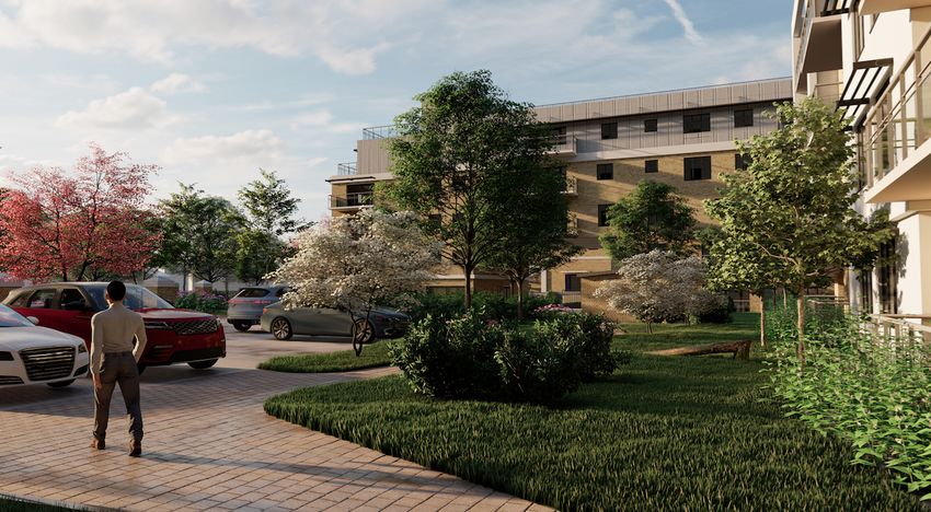
Statement of Consistency                                                                            Ian Doyle
                                                                                           Planning Consultant

 1.0      Introduction

 This Statement of Consistency has been prepared by Ian Doyle Planning Consultant on behalf Blathas
 Property limited with in consultation with the project design team consisting of BG Architecture, MHL &
 Associates Ltd Traffic Consultants, Gannon + Associates Landscape Architecture, Deborah Darcy
 Ecologist, C&W O'Brien 3D Consultant, EDC Consulting Engineers, Civil & Structural Engineers DMA Ltd.
 CLC Consulting Engineers (Shadow Analysis) and Scollard Doyle QS and Project Management.

 The proposed development site is located adjacent to Lambs Cross junction in Sandyford which is under
 the administrative jurisdiction of Dún Laoghaire-Rathdown County Council. The site is bounded to the
 east by Sandyford Road, to the south by Blackglen Road, and to the north & west by Fitzsimon’s Wood.
 The site consists of rocky overgrown scrublands with no ecological value. There is an existing cottage on
 the northern portion of the site which it is proposed to remove. Lambs Cross has a number of services
 including a shop, Veterinary clinic, hair & beauty salon, community centre and a national school while
 Sandyford Village, Stepaside Village & Dundrum Town are all within close proximity. Sandyford Business
 District, which makes up much of the suburb of Sandyford and encompasses Sandyford Industrial Estate,
 is located within 1.5 Km, of the site and is one of the biggest business parks in Ireland, consisting of over
 500 companies employing approximately 20,000 people. These include financial services and technology
 companies such as Google, Facebook, Microsoft and AIB.

Sandyford Business District

                  Site Location

 The proposed “Fitzsimons Wood” Strategic Housing Development consists of a mixed use development
 of four blocks of apartments (143 residential units in total catering for a maximum number of 494

                                                                                                            2
 Strategic Housing Development Lambs Cross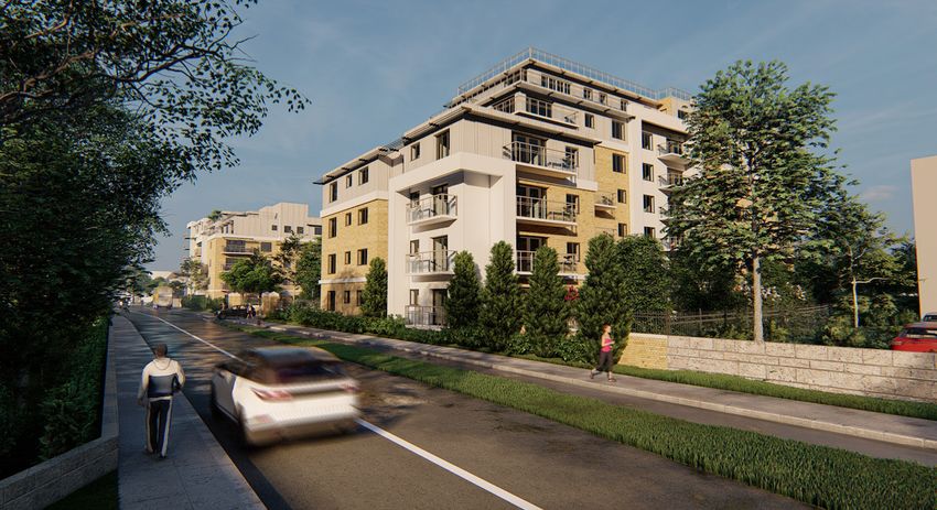
Statement of Consistency                                                                           Ian Doyle
                                                                                         Planning Consultant

occupants) with non -residential uses on the ground floor of block A (total site area 0.8ha). Non -
residential uses include Communal Room, Hot Desk Area, Commercial Unit, x2 Office units, Coffee Shop,
Gym, Community Room, x4 live work units and a Crèche. Vehicular access & egress will be taken from
Sandyford Road which will benefit from improved services as part of the Bus Connects program. (Bus
Connects is a national program of investment in the bus network of the Greater Dublin Area into the
near future). A bus stop will be provided along the eastern boundary of the site as part of the bus
connects program.

A formal pedestrian access route is provided from the bus stop through the residential/mixed use
element of the site to “Gorse Hill” to the rear of the site. Gorse Hill is an area of scrublands of 2.8ha to
the rear of the applicants landholding zoned for Open Space. A pedestrian link through Gorse Hill to
Fitzsimons Wood via a raised boardwalk forms part of the development in addition to extensive tree
planting to support and reinforce Fitzsimons Wood (pNHA). Gorse Hill is in the ownership of the council
and forms part of the subject application. A letter of consent from the council for the proposed works
accompanies the planning application.

Development proposals for Gorse Hill and the associated link to Fitzsimons Wood, were developed in
partnership with the Councils Parks Department and Biodiversity Officer and National Parks & Wildlife
Service. Development of this link represents a substantial planning gain for the wider community
including the youth education groups that currently use Fitzsimons Wood in an educational capacity.

The proposed for Gorse Hill are fully integrated into the subject application and accordingly have been
assessed appropriately by the accompanying documentation namely Landscaping proposals, Ecological
Assessment, Construction Management and Maintenance Management Plans. On completion of the
development Gorse Hill shall be taken in charge by the Council.

This document seeks to establish that the proposed development in is full compliance with all relevant
National, Regional and Local planning policy and in particular the policies and objectives of the Dún
Laoghaire-Rathdown County Development Plan and all relevant Government Guidance notes. This pre-
planning application request is being submitted under the Strategic Housing Development (SHD)
planning provisions.

1.1     Legislative Context

The Planning & Development (Strategic Housing Development) Regulations 2017 state that all SHD
applications must be accompanied by a Statement of Consistency demonstrating that the development
proposal is consistent with Local Policies (as identified by the relevant Local Development Plan) and
relevant Planning Guidance Documents issued by the Department of Housing, Planning & Local
Government. This Statement of Consistency clearly demonstrates that the proposed development fully
accords with national, regional and local planning policy in addition to the following Guidance
Documents:

                                                                                                           3
Strategic Housing Development Lambs Cross
Statement of Consistency                                                                        Ian Doyle
                                                                                      Planning Consultant

1.      Project Ireland 2040 - The National Planning Framework;

2.      Rebuilding Ireland: Action Plan for Housing and Homelessness (2016);

3.      Eastern & Midlands Regional Assembly Regional Spatial & Economic Strategy (2019-2031)

4.      Greater Dublin Area Transport Strategy 2016 – 2035

5.      Sustainable residential development in Urban Areas (May 2009)

6.      Urban Design Manual – A Best Practice Guide (2009);
7.      Sustainable Urban Housing: Design Standards for New Apartments- Guidelines for Planning
        Authorities;
8.       Urban Development and Building Heights – Guidelines for Planning Authorities
        (December2018);
9.      Design Manual for Urban Roads and Streets (2013);
10.     Guidelines for Planning Authorities on Childcare Facilities (2001).
11.     Part V of the Planning and Development Act 2000: Guidelines issued by the Minister for
        Housing, Planning, Community and Local Government under section 28 of the Planning and
        Development Act 2000 (2017)
12.     Appropriate Assessment of Plans and Projects in Ireland Guidance for Planning Authorities
        (2009)
12.     Dun Laoghaire-Rathdown County Development Plan 2016-2022

2.0     The Proposed Development

The proposed development will be described and advertised as follows:

The development will consist of “demolition of existing dwelling on site and permission for a mixed
use development consisting of 143 Residential Units, including 4 live work units (Block A =34, Block B =
27, Block C = 48, Block D = 34) Communal Room (36sq.m) Hot Desk Area (36sqm) Commercial Unit
(42sq.m) x2 Office units (Office 1, 48sq.m Office 2, 97sq.) Coffee Shop 42sq.m, Gym 115sq.m, Community
Room 36sq.m and a Crèche 200sq.m. Together with 166 Car Parking Spaces (9 surface spaces and 157
basement spaces inclusive of 5 disabled spaces and 5 car share), raised pedestrian board walk,
landscaping/tree planting and all associated works”.

                                                                                                       4
Strategic Housing Development Lambs Cross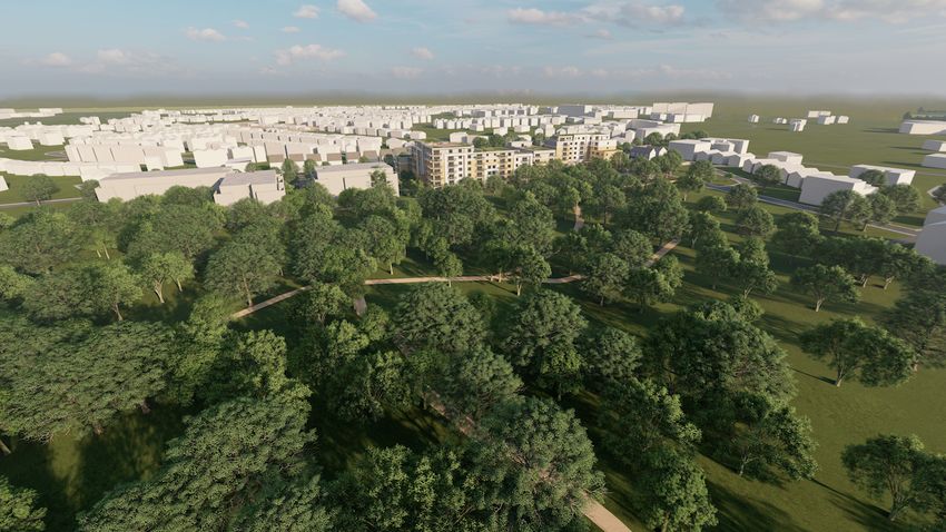
Statement of Consistency                                                                          Ian Doyle
                                                                                        Planning Consultant

2.1     Planning History

The following planning history relates to the subject site:

D03A/0699

Three storey building containing 2 no. retail units at ground floor – Withdrawn

D04A/0009

Two/three/four storey building over basement, comprising of 4 no. 1 bedroomed and 28 no. 2
bedroomed apartments, 6 no. retail units and restaurant - total gross floor area 5,722 msq. Ground floor
to consist of 2 no. 2 bedroomed apartments, with 5 no. stairwells to service apartments above, 6 no.
retail units-net trading area - 527 msq and restaurant - net trading area 120 msq, with ancillary holding
kitchen, disabled toilet, storage, entrance lobby and retail residential refuse storage. 14 no. car parking
spaces to rear of development, with vehicular access from the Sandyford Road. First floor to consist of
12 no. 2 bedroomed apartments. Restaurant net trading area - 78 msq with ancillary toilets, prep
kitchen and reception area. Second floor to consist of 3 no 1 bedroomed apartments and 12 no. 2
bedroomed apartments. Third floor to consist of 1 no. 1 bedroomed apartment and 1 no. 2 bedroomed
apartment, 5 no. stair cores to access plant areas within roof space. Basement to consist of kitchen to
serve restaurants above, dry goods, bottle, cold stores and staff accommodation, pedestrian access to
ground floor, 45 no. car parking spaces, and bike storage. Site to be landscaped to achieve 41% public
open space and 14 no. surface level car parking spaces

Granted by the council refused on appeal. November 2004

D06A/0988

2 storey, 4 bedroomed house, new boundary walls, entrance, entrance gates, pillars and all associated /
ancillary site works

Granted September 2006

2.2     Adjoining site

Permission for a residential development consisting of the demolition of the existing dwelling house and
sheds and the construction of 67 no. apartments in 3 no. three storey plus penthouse blocks (Blocks A, B
& C) containing in total 5 no. one bed units, 48 no. two bed units and 14 no. three bed units. The
development will also include a basement (under blocks B & C), on surface car parking, the construction
of a new site entrance from the public road and all associated site and landscaping works on a 1.09
hectare site

Granted on Appeal 27th of March 2019

                                                                                                          5
Strategic Housing Development Lambs Cross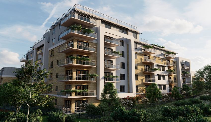
Statement of Consistency                                                                              Ian Doyle
                                                                                            Planning Consultant

3.0       National Planning Framework (Ireland 2040 – Our Plan)

The National Planning Framework (NPF), published in February 2018, sets out the strategic development
framework for Ireland from 2018 to 2040. The purpose of the National Planning Framework is to cater
for the predicted population increase of one million people, to aid in the creation and facilitation of
660,000 additional jobs and to provide 550,000 more homes by 2040.

The Framework focuses on:

      •   Sustainable Regional Development, with the five cities of Dublin, Cork, Limerick, Galway and
          Waterford accounting for 50% of future growth, while larger towns, villages and associated rural
          fabric accounting for the remaining 50%.
      •   Building more sustainable, accessible and balanced urban centres through compact growth and
          sustainable mobility policies
      •   A stronger economy supported by enterprise, innovation and skills, facilitated by enhanced
          regional access and high quality international connectivity
      •   A transition to a low Carbon and Climate Resilient Society through sustainable management of
          water, wastewater and environmental resources
      •   Better access to quality childcare, education and health services

While the overarching goal of the framework is “to enable all parts of Ireland, whether rural or urban, to
successfully accommodate growth and change, by facilitating a shift towards Ireland’s regions and cities
other than Dublin”, the framework does contain specific policies under the heading “Irelands Capital”
which includes the following:

      •   Supporting the future growth and success of Dublin as Ireland’s leading global city of scale, by
          better managing Dublin’s growth to ensure that more of it can be accommodated within and
          close to the city.
      •   Enabling significant population and jobs growth in the Dublin metropolitan area, together with
          better management of the trend towards overspill into surrounding counties.

This will be achieved through “Compact Growth” by:

      •   Targeting a greater proportion (40%) of future housing development to be within and close to
          the existing ‘footprint’ of built-up areas.
      •   Making better use of under-utilised land and buildings, including ‘infill’, ‘brownfield’ and publicly
          owned sites and vacant and under-occupied buildings, with higher housing and jobs densities,
          better serviced by existing facilities and public transport.

The Framework estimates that the population of Dublin City and suburbs will grow by 25% by 2040 of
which 40% will be within the established urban footprint on infill/brownfield development sites.

National Policy Objective 11 of the Framework states:

                                                                                                             6
Strategic Housing Development Lambs Cross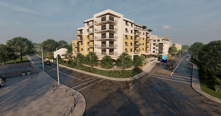
Statement of Consistency                                                                            Ian Doyle
                                                                                          Planning Consultant

“In meeting urban development requirements, there will be a presumption in favour of development that
can encourage more people and generate more jobs and activity within existing cities, towns and
villages, subject to development meeting appropriate planning standards and achieving targeted
growth”.

The Framework further states that “there are many areas in our cities, towns and villages that contain
lands and buildings not developed or used to their full potential”. The subject site is characterized as
such, infill/brownfield and within the existing urban footprint. The framework recognizes that:

“To enable brownfield development, planning policies and standards need to be flexible, focusing on
design led and performance-based outcomes, rather than specifying absolute requirements in all cases.
In particular, general restrictions on building height or universal standards for car parking or garden size
may not be applicable in all circumstances in urban areas and should be replaced by performance-based
criteria appropriate to general location”

A more dynamic performance-based approach appropriate to urban location type will also enable the
level of public transport service to improve as more development occurs and vice-versa. There should
also generally be no car parking requirement for new development in or near the centres of the five
cities, and a significantly reduced requirement in the inner suburbs of all five, e.g. city/town centre,
public transport hub, inner suburban, public transport corridor, outer suburban, town, village etc”.

Comment:

The subject site is clearly defined as being infill, brownfield and within the established urban footprint of
Dublin City. The site is consistent with the above definition of underutilised land zoned for development
and proximate to established social infrastructure. The propose development represents a dynamic and
appropriately considered design response which will provide a landmark building at Lambs Cross and
establish precedent for further sustainable, high quality high density development in the general area.

The site’s location on a quality bus corridor and within a short walking and cycling distance of a Luas
(1.2km) encourages increased densities that will contribute to the consolidation of Dublin city. The
proposed development is in full accordance with the requirements and recommendations of the
National Planning Framework.

4.0     Rebuilding Ireland: Action Plan for Housing and Homelessness (2016)

Rebuilding Ireland Action Plan for Housing and Homelessness was launched in 2016 with the primary
goal of ramping up housing supply across all tenures to help individuals and families meet their housing
needs.

                                                                                                            7
Strategic Housing Development Lambs Cross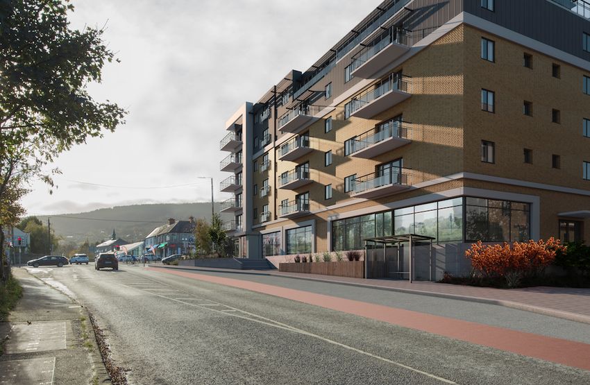
Statement of Consistency                                                                           Ian Doyle
                                                                                         Planning Consultant

The Action Plan sets “ambitious targets to double the annual level of residential construction to 25,000
homes and deliver 47,000 units of social housing in the period to 2021, while at the same time making
the best use of the existing housing stock and laying the foundations for a more vibrant and responsive
private rented sector”.

The core objectives of the plan relative to the proposed development include:

    •   Moderating rental and purchase price inflation, particularly in urban areas;
    •   Maturing the rental sector so that tenants see it as one that offers security, quality and choice of
        tenure in the right locations and providers see it as one they can invest in with certainty;
    •   Delivering housing in a way that meets current needs while contributing to wider objectives
        such as the need to support sustainable urban and rural development and communities and
        maximise the contribution of the built environment to addressing climate change.

The Action Plan identifies key high level actions for new housing provision across five key pillars as
follows:

    •   Pillar 1 – Address Homelessness
    •   Pillar 2 – Accelerate Social Housing
    •   Pillar 3 – Build More Homes
    •   Pillar 4 – Improve the Rental Sector.
    •   Pillar 5 – Utilise Existing Housing Ensure that existing housing stock is used to the maximum
        degree possible

                                                                                                           8
Strategic Housing Development Lambs Cross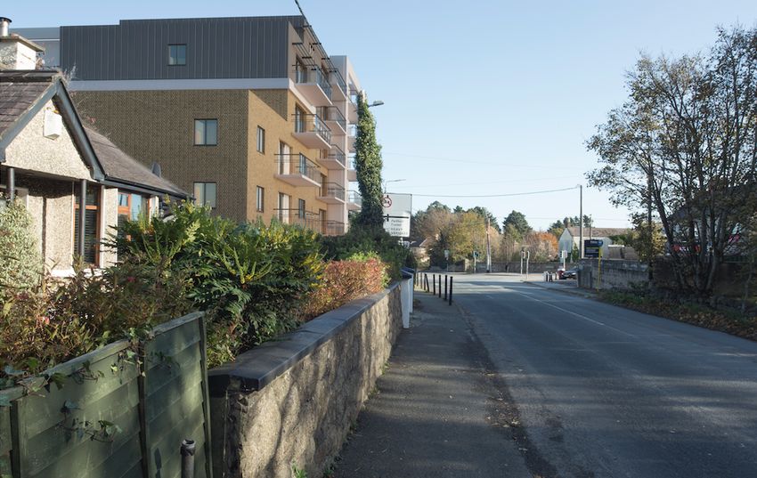
Statement of Consistency                                                                             Ian Doyle
                                                                                           Planning Consultant

Comment

The proposed development on zoned, serviced lands within the established urban footprint in close
proximity to public transport infrastructure will result in the provision of a total of 143 residential units
across a wide range of unit types which will facilitate a strong mix of household types catering for all
housing needs. With regards to the pillars listed above, the proposed development will directly address
the following:

Pillar 2- Accelerate Social Housing

The proposed development is in full accordance with the provision of Part V of the Planning and
Development Act 2000 (as amended). The requirements of Part V regarding provision of social housing
units have been discussed and agreed with the Housing Department of DLRCC, details of which have
been submitted with the subject SHD planning application.

Pillar 3 – Build More Homes

As previously stated, the proposed development will result in a total of 143 units across 3 unit types. For
a full schedule of units provided refer to Appendix 1 of this report.

Pillar 4 – Improve the Rental Sector

The proposed development will indirectly contribute to Pillar 1 (Address Homelessness) by contributing
to the increase in the overall extent of housing stock and through meeting Part V Social Housing
obligations. As this is a new housing scheme which does not utilize existing housing stock, pillar 5 is not
applicable.

5.0     Eastern & Midlands Regional Assembly Regional Spatial & Economic Strategy (2019-2031)

The primary objective of Eastern & Midlands Regional Assembly Regional Spatial & Economic Strategy
(RSES) is to support the implementation of Project Ireland 2040 linking planning and investment through
the National Planning Framework (NPF). The RSES is required under the Planning and Development Act
2000 (as amended) to address Employment, Retail, Housing, Transport, Water services, Energy and
communications, Waste management, Education, health, sports and community facilities, Environment
and heritage, Landscape, Sustainable development and climate change. The RSES for the Eastern and
Midlands Region includes Counties, Louth, Meath, Kildare, and Wicklow in addition to Dublin and
provides policies with regards to:

                                                                                                                9
Strategic Housing Development Lambs Cross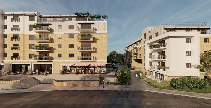
Statement of Consistency                                                                          Ian Doyle
                                                                                        Planning Consultant

    •   Spatial Strategy – to manage future growth and ensure the creation of healthy and attractive
        places to live and work
    •   Dublin Metropolitan Area Strategic Plan (MASP) – to ensure continued competitiveness of
        Dublin and a supply of strategic development for sustainable growth
    •   Economic Strategy – that builds on our strengths to create a strong economy and jobs, that
        ensures a good living standard and economic opportunity for all
    •   Climate Action Strategy – to accelerate action and ensure a clean and healthy environment,
        sustainable transport and green infrastructure.
    •   Investment Framework – to prioritise the delivery of infrastructure and enabling services by
        government and state agencies

The RSES states the following:

“The region is young and diverse, with 1 in 5 people under 14 years of age and more than 1 in 8 residents
who are non- Irish nationals. By 2031 there will be a significant increase in people over 65 years of age
and a key challenge will be to ensure positive health outcomes and a good quality of life for our older
people. There will also be an increase in the 15-24 year age cohort and a continued long term trend
towards smaller and one person households”.

The RSES identifies Dublin as the State’s only city of global scale, with access to national and
international markets through Dublin Airport and Port, with a varied enterprise base, vibrant arts and
culture and a young well-educated population. The RSES states that the concentration of multi-
nationals, ICT and services and large number of third level institutes and research centres make Dublin
an ideal innovation test bed but recognizes that capacity constraints in housing and infrastructure must
be addressed to ensure continued competitiveness as a national economic driver.

The RSES Settlement Strategy identifies the subject site as being located within the Dublin City
Metropolitan Area. The overall vision for the Dublin Metropolitan area is

“To build on our strengths to become a smart, climate resilient and global city region, expanding access
to social and economic opportunities and improved housing choice, travel options and quality of life for
people who live, work, study in or visit the Dublin metropolitan area”

The settlement strategy identifies Sandyford and Cheerywood for “continued development of high-
density business districts” in addition to further LUAS green line, public transport and roads upgrades.

The Strategy reiterates the NPF principle of compact and sustainable growth with a target of 30-40% of
new homes to be built on land within the metropolitan area.

                                                                                                           10
Strategic Housing Development Lambs Cross
Statement of Consistency Ian Doyle
Planning Consultant
Comment
The subject lands are located within the
metropolitan area of Dublin in Sandyford which is
identified by the RSES as an area for continued high
density development as a business district. It is
envisaged that the subject development which is
within short travelling distance to Sandyford
Business Park will complement this emerging
business district through providing modern
residential development within walking/cycling
distance. The Dublin Metropolitan Area Strategic
Plan included in the RSES envisages a total
population of 1.65 million for the metropolitan area
by 2031 which represents an increase of 250,000
people. The subject development and associated 143
units will contribute towards achieving this target.
6.0 Greater Dublin Area Transport Strategy 2016 – 2035
This Greater Dublin Area Transport Strategy (Strategy) provides a framework for the:
“ Planning and delivery of transport infrastructure and services in the Greater Dublin Area (GDA) over
the next two decades. It also provides a transport planning policy around which other agencies involved
in land use planning, environmental protection, and delivery of other infrastructure such as housing,
water and power, can align their investment priorities”
The Greater Dublin Area Transport Strategy divides Dublin into 6 Radial Transport Corridors. The subject
site located within Corridor F: Arklow – Wicklow – Greystones – Bray – Cherrywood – Dundrum – Dún
Laoghaire – to Dublin City Centre. With regard to Corridor F, the Strategy States:
During the preparation of the Strategy, the Authority prepared a report on the South East corridor. This
study primarily aimed to identify public transport options that could effectively meet the growth in
travel demand to year 2035, between the South East Study Area and Dublin City Centre. A number of
options to cater for transport growth were examined. This included the upgrading of the Green line to
Metro standard all the way to a point in Bray. Other options included focusing on the DART and a
combination of BRT and bus priority to service growth, including a BRT network linking to the upgraded
Metro at Bride’s Glen or Sandyford.
11
Strategic Housing Development Lambs CrossStatement of Consistency Ian Doyle
Planning Consultant
Comment
Plans are currently underway for a 5 million Euro project to upgrade the Sandyford road to that of a
Quality Bus Corridor. The works (which include bus priority measures & bus lanes, road widening,
junction improvements to Lambs Cross, provision of cycle lanes & footpaths, surface water sewer,
watermain, telecom ducting and public lighting provision) are scheduled to commence Q1 2021. The
works will take 18 months to complete and as such will be completed prior to that of the subject
application. The proposed development has been designed to incorporate these upgrades including the
location of a bus stop immediately adjacent to the subject site. The planed infrastructural and public
transport upgrades are integrated into the above mentioned strategy for Greater Dublin Area.
7.0 Sustainable Residential Development in Urban Areas Guidelines for Planning Authorities 2009
The Sustainable Residential Development in Urban Areas - Guidelines for Planning Authorities, 2009 and
its associated partner document The Urban Design Manual – A Best Practice Guide, 2009 set out the key
planning principles to guide the preparation and assessment of planning applications for residential
development in urban areas.
The guidelines promote higher densities in the context of three significant social, economic and
environmental considerations, namely:
• The trend towards smaller average household sizes,
• The need to encourage the provision of affordable housing, particularly in the
greater Dublin area, and
• The need to reduce CO2 emissions by reducing energy consumption and to support
a more efficient use of energy in the residential and transport sectors, in particular
higher residential densities in locations which are, or will be, served by public
transport
With regards to building height section 5.3 of the guidelines states the following:
“Particular sensitivity is required in relation to the design and location of apartment blocks which are
higher than existing adjacent residential development. As a general rule, where taller buildings are
acceptable in principle, building heights should generally taper down towards the boundaries of a site
within an established residential area”.
With regards to public transport corridors and residential density, section 5.8 of the guidelines state:
12
Strategic Housing Development Lambs CrossStatement of Consistency Ian Doyle
Planning Consultant
“Walking distances from public transport nodes (e.g., stations/halts/bus stops) should be used in
defining such corridors. It is recommended that increased densities should be promoted within 500
metres walking distance of a bus stop, or within 1km of a light rail stop or rail station.”
The subject site is consistent with the guidelines definition as “Inner suburban / infill”.
Comment
As required by the guidelines, the building heights of the proposed development are generally 6 storey
with step downs to 5 and 4 storey’s at sensitive locations and proximate to existing development to
avoid negative impacts. A step up to 7 storey’s at block C & D in the centre of the site is proposed to
facilitate high densities along a primary public transport route. The proposal consists of an appropriate
mix of one, two and three bed apartments in consideration of the trend towards smaller average
household sizes. The proposed development will contribute to the provision of affordable housing
through meeting all required Part V obligations.
In terms of existing public transport infrastructure, a Mobility Management Plan prepared by M.H.L. &
Associates Ltd. Consulting Engineers accompanies this pre-application consultation request and states
the following:
• Lambs Cross is served by the 44B bus route which runs from Glencullen to Dundrum Luas Station
and the 114 bus route which runs from Simon’s Ridge to Blackrock Station.
• Both Dundrum Town & Blackrock Station have numerous bus routes to neighbouring districts as
well as Dublin City Centre.
• A DART service is available at Blackrock Station while Dundrum has a Luas station.
• Glencairn is the closest Luas stop to the development and is located within 5 minutes’ cycle or
20 minutes’ walk. A park and ride facility is also available at Glencairn Luas Stop.
There is a bus stop located along the roadside boundary of the subject site and the proposed
development has been designed with this in mind. Particular attention has been given to encouraging
activity/connectivity at street level in the vicinity of the bus stop with the proposed pedestrian access to
Fitzsimons wood also converging at this point.
With regards to cycling connectivity the Mobility Plan notes:
“250m north of the development, a cycle lane/track runs the whole way into Dublin City Centre almost
unbroken via the R117& R825. This network also passes through Dundrum Town & Ranelagh. The
distance from Lambs Cross to O’Connell Street in the centre of Dublin City is approximately 11km (35min
cycle). Cycle lanes link Lamb’s Cross with Stepaside Village south along the R117 (5 min cycle) and with
Sandyford Business District north along the R117 and via Blackthorn Drive (5 min cycle). The south east
13
Strategic Housing Development Lambs CrossStatement of Consistency Ian Doyle
Planning Consultant
section of the Business District which includes Microsoft’s European Headquarters can be reached in less
than 10 minutes cycle via the R113. There are cycle lanes available along the R113 from the junction of
the R113/Kilgobbin Road which is approximately 600m east of Lamb’s Cross. The closest Luas Stop
(Glencairn) is only about a 5min cycle east along the R113. There are also bicycle racks available at the
Stop.”
In the context of the connectivity of the subject site via existing and proposed public transport increased
densities are considered appropriate and justifiable in this instance.
8.0 Sustainable Residential Development in Urban Areas Urban Design Manual
The Sustainable Residential Development in Urban Areas Urban Design Manual is a partner document to
the above mentioned Guidelines for Planning Authorities. The Urban Design Manual is:
“Based around 12 Criteria that have been drawn up to encapsulate the range of design considerations
for residential development. They are, in essence, a distillation of current policy and guidance and tried
and tested principles of good urban design”.
14
Strategic Housing Development Lambs CrossStatement of Consistency Ian Doyle
Planning Consultant
The subject development is assessed against the 12 identified criteria as follows:
8.1 Context
How does the development respond to its surroundings?
The subject site is located in a peripheral but transitional area within metropolitan Dublin. While the site
is located opposite a two storey shop/neighborhood centre and adjacent to a bungalow it is lacking in
any noteworthy context and as such there is a clear opportunity to establish a context/precedent for
future development in the immediate area. A Visual Impact Assessment has been carried out as
requested by An Bord Pleanala durung pre planning discussions and should be considered in tandem
with the Architectural Design Statement while assessing context.
The site occupies a strategic position in urban design terms with the potential to create a focal point at
Lambs Cross junction. While the general area can be described as low density/edge of urban
brownfield almost rural in nature, this is mostly due to Gorse Hill/Fitzsimons Wood to the rear of the
site. As previously stated the proposal incorporates upgrade works to Gorse Hill to link the development
site to Fitzsimons Wood for use by the public and school groups in accordance with the Council
Biodiversity and Development Plans to complement the proposed apartments. The design and layout of
the proposed raised walkway took place in partnership with the Councils Parks and Biodiversity Officers.
In addition, the proposed apartments will function as a hard edge to Fitzsimons wood in visual terms
bookending the Woods and clearly delineating the boundary between the natural and built
environments. The site boundary will consist of native beech wood planting to reinforce Fitzsimmons
Wood and extensive beech wood planting is also proposed for Gorse Hill.
As advised by the guidelines, the height of the proposed development is tapered down from 6 storey’s
to 5 storey’s to 3 storey’s along the western boundary of the site (as detailed by section A-A of the
accompanying drawings). The third floor of proposed apartment block A is set back 9.6m from the
neighboring dwelling at a height of 4m above the ridge height of the adjacent bungalow while the 5th
floor site 17m away at a height of 9m above the ridge line of the adjacent dwelling.
Balconies along this boundary are restricted to the 4th and 5th floors only where there is no potential for
overlooking of the neighbouring property. Proposed Windows along this elevation (secondary
bedrooms) are minimum and sufficiently set back to prevent undue overlooking or loss of amenity.
15
Strategic Housing Development Lambs CrossStatement of Consistency Ian Doyle
Planning Consultant
16
Strategic Housing Development Lambs CrossStatement of Consistency Ian Doyle
Planning Consultant
Above Landmark structure at Lambs Cross Junction tapered down in height to site boundaries
17
Strategic Housing Development Lambs CrossStatement of Consistency Ian Doyle
Planning Consultant
8.2 Connections
How well connected is the new neighbourhood?
As previously stated:
• Lambs Cross is served by the 44B bus route which runs from Glencullen to Dundrum Luas Station
and the 114 bus route which runs from Simon’s Ridge to Blackrock Station.
• Both Dundrum Town & Blackrock Station have numerous bus routes to neighbouring districts as
well as Dublin City Centre.
• A DART service is available at Blackrock Station while Dundrum has a Luas station.
• Glencairn is the closest Luas stop to the development and is located within 5 minutes’ cycle or
20 minutes’ walk. A park and ride facility is also available at Glencairn Luas Stop.
• A cycle lane/track runs the whole way into Dublin City Centre almost unbroken via the R117&
R825. This network also passes through Dundrum Town & Ranelagh
• In terms of permeability and connectivity the proposed raised woodland boardwalk connects
Fitzsimons wood to the subject site and forms the focus of pedestrian movement through the
subject site from the proposed bus stop.
• Bus, Luas & DART routes and timetables can be found in Appendix B of the Mobility
Management Plan which accompanies the subject planning application.
8.3 Inclusivity
How easily can people use and access the development?
As the proposed development occupies a corner site at a crossroads footpaths are provided along all
street edges. There are three pedestrian access points to the site and one vehicular access point. The
site is divided in two by a main pedestrian/cycle distributor route through the site from the bus stop to
Fitzsimmons Wood. This access point is graded and wheelchair friendly.
All residential units are designed to be fully accessible for people with disabilities and the scheme is fully
compliant with Part M of the Building Regulations. Four own-door, ground floor live/work units are also
proposed in addition to closely located disabled car parking space. High-quality, communal and private
amenity spaces are proposed in the form of private balconies and roof gardens (private and communal)
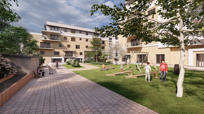
in addition to a children’s play area to the rear of Block A. Public open space is provided at strategic
locations throughout the development while a crèche to serve future residents is also proposed.
The proposed works to Gorse Hill which will provide a raised bedestrian boardwalk link to Fitzsimons
Wood represent significant community gain in the form of additional public open space/amenity
provision.
18
Strategic Housing Development Lambs CrossStatement of Consistency Ian Doyle
Planning Consultant
View of pedestrian access from Fitzsimons Wood
View of pedestrian access from Sandyford Road
19
Strategic Housing Development Lambs CrossStatement of Consistency Ian Doyle
Planning Consultant
8.4 Variety
How does the development promote a good mix of activities?
The proposed mix of unit size and type has been designed to cater for all sectors of the housing market.
As is consistent with best practice and the requirements of “The Sustainable Urban Housing: Design
Standards for New Apartments Guidelines for Planning Authorities” (published by the Department of
Housing, Planning and Local Government in March 2018) the proposed scheme includes a number of
Resident Support Facilities namely a gym, a crèche, a communal room, community room and resident’s
hot desk area. A commercial unit, two offices and a coffee shop are also proposed at ground floor level
of Block A all of which open onto a public plaza, which in urban design terms, will punctuate Lambs
Cross crossroads. Four live/work units are also proposed with shop front designed own door street
access work units with an internal link to the associated live units. In addition to contributing to the
general mix of uses required by the zoning provisions for the site, the live/work units are located at key
points along the pedestrian route through the site from the bus stop to Gorse Hill to provide for natural
surveillance.
8.5 Efficiency
How does the development make appropriate use of resources, including land?
There are two distinctive elements to the application site namely the development area which is 0.8ha
in size and Gorse Hill which is 2.8ha in size. Assuming the applicants land holding only, a density of 145
units per ha is proposed. Considering the total proposed development area (development site plus
Gorse Hill) of 3.6ha a density of 39.7 units per Ha is proposed.
The site is defined as suburban infill in the context of the Sustainable Residential Development in Urban
Areas Guidelines. High density is justified in this instance given the site’s proximity to public transport
and sustainable access (walking and cycling) to areas of employment. Private and public open space is
provided in excess of required standards. Parking provision is provided in excess of one space per unit
and includes car share facilities. Roof space is utilized for open space and increased biodiversity. The
proposed development represents the efficient use of land.
20
Strategic Housing Development Lambs CrossStatement of Consistency Ian Doyle
Planning Consultant
8.6 Distinctiveness
How do the proposals create a sense of place?
The proposed scheme will result in the creation of a landmark building at Lambs Cross. The notable lack
of existing surrounding development affords the opportunity to establish precedent for high quality high
density development in a suburban metropolitan area well served by public transport and proximate to
areas of employment concentration. Active Street frontages are provided along street edges in addition
to a focal point at street level which consists of the convergence of a pedestrian access street to
Fitzsimons Wood and a public transport node.
8.7 Layout
How does the proposal create people friendly streets and spaces?
The scheme design facilitates the car through a pedestrian dominant environment with minimal
potential for vehicular pedestrian conflict The scheme is DMURS compliant and a Traffic Impact
Assessment and road safety audit have been prepared and accompany the subject application.
8.8 Public Realm
How safe, secure and enjoyable are the public areas?
All public areas are sufficiently overlooked including pedestrian routes/open space, and all access points
to and from the site including the pedestrian access through the site to Fitzsimons Wood. A Children’s
play area together with formal active open space is located to the rear of Block A. This area offers the
most footfall in terms of pedestrian activity, is overlooked and removed from the vehicular access route
from the entrance of the site to the basement car park. There will be no potential for vehicular
pedestrian conflict. A proposed public plaza at the corner of Lambs Cross (Block A) will be served by a
coffee shop, with complementing commercial and office developments in addition to a gym, a hot desk
area and a crèche for residents.
21
Strategic Housing Development Lambs CrossStatement of Consistency Ian Doyle
Planning Consultant
Overlooking/natural surveillance of children’s play areato the rear of Block A
8.9 Adaptability
How will the buildings cope with change?
All apartments as proposed are adaptable and considered appropriate for cross-generational use.
8.10 Privacy and Amenity
How does the scheme provide a decent standard of amenity?
A strong variety of amenity space is provided in addition to proposals to increase connectivity to existing
surrounding amenity space. The overall area of the applicants landholding dedicated to active open
space is the equivalent to 17% of the site area. Further passive open space is provided at 8%. All
apartments have access to private open space in the form of balcony’s and communal roof gardens are
proposed for blocks B, C & D which are equivalent to 17% of the site area. The proposed works to Gorse
Hill by means of extensive tree planting and the provision of a raised pedestrian walkway to Fitzsomons
wood represents an amenity area of 2.8ha which the developer will provide as planning gain for the
wider community in partnership with the council.
The orientation of the apartment blocks are such that no undue loss of privacy will occur.
22
Strategic Housing Development Lambs CrossStatement of Consistency Ian Doyle
Planning Consultant
8.11 Parking
How will the parking be secure and attractive?
All parking requirements for the development will be facilitated within the site via provision of a
basement car park accessed under the proposed arch at block B. A total of 166 spaces are proposed (9
surface spaces and 157 basement spaces inclusive of 5 disabled spaces and 5 car share). 234 cycle
parking spaces and all associated works”.
The proposed 5 car share spaces (via a car share company such as "Go-Car" or “Green Mobility both of
whom have expressed an interest in operating facilities from the site”) will function in the same capacity
as 75 parking spaces. A single car share space is the equivalent of 15 standard parking spaces in terms of
development plan standards. According to the accompanying Mobility Management Plan the
Development Plan requires 219 parking spaces. The proposed 166 spaces taken together with the car
share allocation achieves a standard provision of 241.
A mobility management plan accompanies this planning application the aim of which is to reduce the
use of the car and to encourage more sustainable transport patters. Electric car charging points will be
provided in addition to 234 cycle parking spaces. Cycle spaces are located throughout the site with
particular attention to natural surveillance and the location of areas of higher pedestrian activity. The
development plan standard requires provision of 188 cycle spaces.
Secure parking areas overlooked
23
Strategic Housing Development Lambs CrossStatement of Consistency Ian Doyle
Planning Consultant
8.12 Detailed Design
How well thought through is the building and landscape design?
The design of the proposed development is the culmination of expertise associated with an
interdisciplinary team led by BG Architecture. The design has evolved over a number of Section 247
consultation meetings with the council and consideration of other influencing factors such as the sites
location proximate to Fitzsimons Wood, which is a proposed Natural Heritage Area and the proposed
improvements to Sandyford Road and associated upgrading to a quality bus corridor. The design of the
connecting raised boardwalk link from the development site to Fitzsimons Wood (Gorse Hill) has been
formulated in partnership with the Biodiversity and Parks Departments of the Council. A full
Architectural Design Statement accompanies the subject application.
Comprehensive landscaping proposed are included for the proposed development including a range of
facilities for children of different ages, parents and the elderly. A mix of open space types including,
private balconies, communal rooftop gardens, a large children’s play area and active open space area to
the rear of block B, transitional mature planting along boundaries, sedum roofs and incidental decretive
planters are proposed. Native boundary planting to the rear of the site considers the transition from the
site to Fitzsimons Wood via Gorse Hill. Extensive planting is proposed at Gorse Hill to reinforce and
extend the (p)NHA woodlands of Fitzsimons Wood. The following table details Open Space provision
within the applicants landholding only and does not include Gorse Hill.
Sq.m % of open space % of site area
Private open space – Balconies 1335 22% 16%
Communal Open space – Roof gardens 535 9% 6%
Children’s Play Area 372 6% 4%
Sedum roof 1776 29% 21%
Mature boundary planting 607 10% 7%
Incidental Open space 1464 24% 17%
Discussions with regards to the development of Gorse Hill between Fitzsimons Wood and the subject
site were ongoing with the council and National Parks and Wildlife through the design process and form
an integral part of the development proposal. The resultant design is one which facilitates the use of
Gorse Hill without negative impact on established habitat. The proposed floating walkway is minimal in
its impacts and respectful of biodiversity. The potential effects are fully discussed in the accompanying
Ecological Assessment and Construction Management Plan.
The applicant sough to develop Gorse Hill following the initial 247 pre- planning meetings with the
council. While not specifically requested to carry out the works or design the proposed improvements to
Gorse Hill, the importance of the interaction between the development site and Fitzsimons Wood as
24
Strategic Housing Development Lambs CrossStatement of Consistency Ian Doyle
Planning Consultant
expressed by the Council prompted the response. The need to enhance the overall development
proposal by directly addressing the transition between the scheme and Fitzsimons Wood by extending
the area of forest associated with the wood while providing permeability and access through the site to
Fitzsimons Wood and, to provide meaningful public open space in partnership with the council. A letter
of consent from the council to carry out the works to Gorse Hill as part of the subject proposals
accompanies this application. The red line boundary includes Gorse Hill and all upgrade works will be
carried out as part of the subject development.
The wood has significant ecological value as a native birch wood forest and as such balancing the
potential for recreational pressure while strengthening existing biodiversity has formed the basis for the
design. Detailed design proposal have been prepared by Gannon + Associates Landscape Architecture in
coordination with the project Ecologist Deborah Darcy and are included in the pre -application
documentation.
Fitzsimons Wood is utilized for educational use for schools, facilities and community groups run by the
children’s nature charity Owls who run a series of outdoor events and workshops throughout the year
aimed at families with young children who want to discover more about their natural heritage whilst
having fun outdoors. The aims of the events are to offer young children experiences that get them in
tune with their natural world, whilst learning and having fun at the same time.
The design therefore seeks to enhance and protect existing biodiversity while facilitating educational
use with minimal ecological impact. To this end a raised wooden walkway is proposed in addition to tree
planting to strengthen the natural birch wood forest of Fitzsimons Wood. The Ecological Appraisal of the
lands identifies a number of newt ponds which will remain undisturbed. A breakdown of the proposed
works to be undertaken by the applicant in partnership with the council is as follows:
Fitzsimons Wood Areas Approx Area
Existing Gorse Area Undisturbed 16,537sq.m
Existing Newt Ponds (2no.) Undisturbed 240sq.m
Proposed Pedestrian link (2.5m wide) 196sq.m
Proposed Seating area (2no) 50sq.m
Proposed extension to Birch Woodland 10,268sq.m
Proposed native screening trees 809sq.m
25
Strategic Housing Development Lambs CrossStatement of Consistency Ian Doyle
Planning Consultant
Proposed connectivity to Fitzsimons Wood
View of proposed development from existing Scrubland to the rear of the site
26
Strategic Housing Development Lambs CrossStatement of Consistency Ian Doyle
Planning Consultant
9.0 Sustainable Urban Housing: Design Standards for New Apartments- Guidelines for Planning
Authorities
The Sustainable Urban Housing: Design Standards for New Apartments- Guidelines for Planning
Authorities were first published in 2015 and subsequently updated in 2018. Initially established to
encourage a consistent National approach to apartment design standards, subsequent revisions seek to
incorporate policies established by the Housing Agency National Statement on Housing Demand and
Supply, the Government’s action programme on housing and homelessness Rebuilding Ireland and
Project Ireland 2040 and the National Planning Framework.
The guidelines reiterate the National Planning Framework (NPF) projected need for a minimum of
550,000 new homes by 2040, at least half of which are targeted for provision in Ireland’s five cities and
recognizes that apartments have a significant role to play in achieving this. Section 1.14 of the guidelines
states the following:
“Given the gap between Irish and European averages in numbers of households living in apartments and
the importance of addressing the challenges of meeting the housing needs of a growing population in
our key cities and towns and by building inwards and upwards rather than outwards, apartments need to
become more and more the norm for urban housing solutions”
The guidelines establish minimum standards and aspirations with regards to the following:
• General locational consideration
• Apartment mix within apartment schemes
• Internal space standards for different types of apartments
• Dual aspect ratios
• Floor to ceiling height
• Apartments to stair/lift core ratios
• Storage spaces
• Amenity spaces including balconies/patios
• Car parking; and
• Room dimensions for certain rooms
Section 2.2 of the guidelines note:
“In general terms, apartments are most appropriately located within urban areas. As with housing
generally, the scale and extent of apartment development should increase in relation to proximity to core
urban centres and other relevant factors. Existing public transport nodes or locations where high
frequency public transport can be provided, that are close to locations of employment and a range of
urban amenities including parks/waterfronts, shopping and other services, are also particularly suited to
apartments”.
27
Strategic Housing Development Lambs CrossStatement of Consistency Ian Doyle
Planning Consultant
Comment
The site is located close to a major employment node (Sandyford Business District), which employs in
the region of 20,000 people. The site is located on a Quality Bus Corridor with a bus stop located on the
roadside boundary. The 44B bus route runs from Glencullen to Dundrum Luas Station and the 114 bus
route runs from Simon’s Ridge to Blackrock Station. Both Dundrum Town & Blackrock Station have
numerous bus routes to neighbouring districts as well as Dublin city Centre. A DART service is also
available at Blackrock Station. Glencairn is the closest Luas stop to the development and is located
within 5 minutes’ cycle or 20 minutes’ walk. A park and ride facility is also available at Glencairn Luas
Stop.
In areas where access to high quality public transport such as this is achievable the guidelines note that
there is there is no upper limit regarding residential density. Assuming the applicants land holding only,
a density of 145 units per ha is proposed. Considering the total proposed development area
(development site plus Gorse Hill) of 2.23ha a density of 46.5 units per Ha is proposed. The density of
the scheme is in accordance with the above Guidelines.
The Specific Planning Policy Requirements of the guidelines are fully addressed by the design of the
proposed development and this is clearly identified by the Accommodation Schedule in accordance with
Section 6.0 of the guidelines which is included in Appendix 1. It is noted that 51 % of the apartments are
dual aspect and that 73% of the apartments are in exceed minimum requirements.
10.0 Urban Development and Building Heights – Guidelines for Planning Authorities (December
2018);
The Urban Development and Building Heights – Guidelines for Planning Authorities were published in
2018 and recognize the need to move away from policies which include generic height restrictions as
the can…..
“undermine wider national policy objectives to provide more compact forms of urban development as
outlined in the National Planning Framework” and “continue an unsustainable pattern of development
whereby many of our cities and towns continue to grow outwards rather than consolidating and
strengthening the existing built up area”.
The guidelines also recognize that blanket limitations can hinder innovation in urban design and
architecture and lead to poor planning outcomes.
“A comparison between the population of the central urban parts of Dublin (approx. 500,000 people)
with the similarly sized central urban parts of Paris (population circa 2.2 million) highlights the potential
that our capital city and other city and large urban areas have to accommodate the needs of a growing
28
Strategic Housing Development Lambs CrossStatement of Consistency Ian Doyle
Planning Consultant
economy and a growing population, without at the same time having to always or predominantly grow
outwards.”
Section 2.3 of the guidelines notes:
“While achieving higher density does not automatically and constantly imply taller buildings alone,
increased building height is a significant component in making optimal use of the capacity of sites in
urban locations where transport, employment, services or retail development can achieve a requisite
level of intensity for sustainability”.
Comment
As previously stated, the subject site is located close to multiple modes of public transport, which offer a
reasonable travel distance from areas of concentrated employment including Dublin City Centre. The
site has little by means of context in terms of surrounding existing development and scope exists to
establish a precedent for high density, high quality sustainable development. The sites location on a
cross road affords the opportunity to create a landmark building by stepping up the height to create a
visual focal point on the Sandyford road.
The proposed development is generally 6 storey’s in height with a step up to 7. All floors above the 4th
floor are set back and employ alternative finishing material. At street level the proposed develop will not
appear to be above 5 storey’s. The proposed development is taller than the “Wynnsfield” development
permitted adjacent but not excessively so. The proposed development will complement the existing
Wynnsfield development providing continuity in terms of the streetscape with a gradual rise to create a
focal point at Lambs Cross Junction. In light of the above the height of the proposed development is
appropriate in this instance. The accompanying Architectural Design Statement includes a
comprehensive assessment of the building heights of the scheme (Section 4 Building). Finally, there are
a number of building in close proximity to the subject lands of a similar height which establishes
precedent in this regards. These include development at Aiken’s Village (6 storey’s) and Belarmine (6
storey’s).
29
Strategic Housing Development Lambs CrossStatement of Consistency Ian Doyle
Planning Consultant
11.0 Design Manual for Urban Roads and Streets (2013)
The Design Manual for Urban Roads and Streets (DMURS) provides design guidance for streets and to
put positive street design at the heart of sustainable communities through well designed transport
networks that promote achievable alternatives to car journeys namely walking, cycling or public
transport.
The manual “recognises the importance of assigning higher priority to pedestrians and cyclists, without
unduly compromising vehicle movement, in order to create secure, connected places that work for all
members of the community”
MHL & Associates Ltd Traffic Consulting Engineers have prepared the following assessments in support
of the proposed development which are included as part of this pre application submission:
• Traffic Impact Assessment
• Mobility Management Plan
• Quality Audit Stage 1
• Road Safety Audit Stage 1-2
The above documents clearly demonstrate compliance with The Design Manual for Urban Roads and
Streets (DMURS)
30
Strategic Housing Development Lambs CrossYou can also read