Illegal Selective Logging and Forest Fires in the Northern Brazilian Amazon - MDPI

Page created by Rick Crawford
 
CONTINUE READING
Illegal Selective Logging and Forest Fires in the Northern Brazilian Amazon - MDPI
Article
Illegal Selective Logging and Forest Fires in the
Northern Brazilian Amazon
Tiago M. Condé 1,2, * , Niro Higuchi 2 and Adriano J. N. Lima 2
 1    State University of Roraima (UERR), Department of Forest Engineering, 69373-000 Rorainópolis, Brazil
 2    Forest Management Laboratory (LMF), National Institute of Amazonian Research (INPA),
      69060-001 Manaus, Brazil; niro@inpa.gov.br (N.H.); adrianolmf@gmail.com (A.J.N.L.)
 *    Correspondence: tiagonafloresta@gmail.com; Tel.: +55-92-98102-3784
                                                                                                     
 Received: 27 December 2018; Accepted: 11 January 2019; Published: 14 January 2019                   

 Abstract: Illegal selective logging and forest fires occur on a large scale in the northern Brazilian
 Amazon, contributing to an increase in tree mortality and a reduction in forest carbon stock. A total
 of 120 plots of 0.25 ha (30 ha) were installed in transitional ecosystems or ecotones (LOt) between
 the forested shade-loving campinarana (Ld) and dense-canopy rainforest, submontane (Ds), in the
 National Forest (Flona) of Anauá, southern Roraima. Measuring the diameters at breast height
 (DBH ≥ 10 cm) and the heights of 171 dead trees (fallen naturally, illegally exploited, and affected
 by forest fires), enabled the estimation of carbon content from the application of a biomass equation
 developed at Manaus, and the calculation of a correction factor, using the average height of the largest
 trees. From 2015–2017, we mapped the real extent of illegal selective logging and forest fires across
 the region with CLASlite and INPE/Queimadas. From measurements of 14,730 live and dead trees
 across 30 hectares (491 ± 15 trees·ha−1 ), the illegal selective logging and associated forest fires, and
 aggravation by severe El Niño droughts resulted in an 8.2% mortality of trees (40 ± 9 dead trees·ha−1 )
 and a 3.5% reduction in forest carbon stock (6 ± 3 Mg·ha−1 ) in the short-term. The surface area or
 influence of forest fires of very high density were estimated in the south-central region of Roraima
 (8374 km2 ) and the eastern region of the Flona Anauá (37 km2 ). Illegal selective logging and forest
 fires in forest areas totaled 357 km2 in the mosaic area, and 6 km2 within Flona Anaua. Illegal
 selective logging and forest fires in the years of severe El Niño droughts threatened the maintenance
 of environmental services provided by Amazonian forests.

 Keywords: carbon; selective logging; fire; forest inventory; El Niño; tree mortality; Amazon forest

1. Introduction
      Tropical forests account for more than half of the Earth’s biodiversity [1], and they are considered
to be important regulators of local and global climate through transpirational water flux, cloud
formation, atmospheric circulation, and carbon storage [2]. Observations at tower and plot-scales
(in situ), and satellite images have shown that tropical deforestation and forest degradation have
resulted in increased temperatures and drought conditions, at both local and global scales [3–5].
The radiation balance at a the local-scale is strongly affected by fires, suffering a net loss of up to 70%
of the photosynthetically active radiation at the surface, and directly influencing plant productivity [6].
The Amazonian hydroclimate is influenced by the textural roughness of the forest canopy [4],
where intense selective logging has resulted in the formation of large clearings and increased tree
mortality [7–9]. The remaining forest structure differs with regards to species composition and carbon
stock, depending on the intensity of selective logging and timber productivity [7–10].
      Illegal selective logging in tropical forests does not occur when environmental and social
sustainability are prioritized, but only when short-term economic returns are sought. In contrast, legal

Forests 2019, 10, 61; doi:10.3390/f10010061                                      www.mdpi.com/journal/forests
Illegal Selective Logging and Forest Fires in the Northern Brazilian Amazon - MDPI
Forests 2019, 10, 61                                                                                                                 2 of 22

     Forests logging
selective    2019, 10, x FOR
                          with PEER REVIEW
                                 sustainable       forest management or reduced-impact logging (RIL) focuses                   2 of 22 on

the multiple use of timber and non-timber resources that are provided by forests, thereby preserving
     legal selective logging with sustainable forest management or reduced-impact logging (RIL) focuses
environmental services [9,11,12]. The long-term viability of the timber trade in the Brazilian Amazon
     on the multiple use of timber and non-timber resources that are provided by forests, thereby
depends     on maintaining
     preserving       environmental an adequate       volume of
                                          services [9,11,12].    The legal   timber viability
                                                                         long-term       extraction, of whilst   maintaining
                                                                                                        the timber     trade in healthy
                                                                                                                                  the
forests
     Brazilian Amazon depends on maintaining an adequate volume of legal timber extraction,timber
         [13].    Man’s      greed   for   the   rapid  and    selective    harvesting         of high-value      tropical    whilst as a
commodity
     maintainingin the     globalforests
                       healthy      marketplace      has greed
                                            [13]. Man's   accelerated
                                                                  for thethe     lossand
                                                                             rapid       of Amazonian       habitatsofbyhigh-value
                                                                                             selective harvesting          deforestation
and tropical
     selectivetimberlogging as a[2,7,14],
                                  commodity  withincritical  consequences
                                                     the global   marketplacefor      hasflora   and fauna,
                                                                                            accelerated          andofcontributions
                                                                                                          the loss      Amazonian to
     habitats
severe  climate  by change.
                     deforestation and selective logging [2,7,14], with critical consequences for flora and fauna,
     and   contributions
      The indiscriminate       to severe
                                   use ofclimate
                                             fire bychange.
                                                      humans in areas of land-use conversion, from native forest to
           The    indiscriminate     use
extensive ranching (cattle) and various    of  fire byagricultural
                                                       humans in areas uses,ofhas land-use     conversion,
                                                                                      contributed            from native
                                                                                                      to an increase        forest toareas
                                                                                                                        of burned
     extensive ranching (cattle) and various agricultural uses, has contributed to an increase of burned
inside  and outside of the native forests of Roraima. The fuel of forest fires in Amazonia are residues that
     areas inside and outside of the native forests of Roraima. The fuel of forest fires in Amazonia are
are left by illegal selective logging, fragmentation, and burned pastures [15,16]. In the past few decades,
     residues that are left by illegal selective logging, fragmentation, and burned pastures [15,16]. In the past
mega forest fires have been observed in the Amazon [3,17], specifically in Roraima [18–20], with strong
     few decades, mega forest fires have been observed in the Amazon [3,17], specifically in Roraima [18–20],
interactions
     with strong between       the severity
                       interactions     between of El
                                                    theNiño   droughts,
                                                         severity            and the
                                                                     of El Niño           occurrence
                                                                                      droughts,     and ofthefires (drought-fire).
                                                                                                               occurrence    of fires
      There    is  little
     (drought-fire).       scientific  information      on  the  impacts       of  illegal   selective   logging    that are associated
with the There
             forestisfires,    on tree mortality
                        little scientific informationand      carbon
                                                          on the impacts  stocks     in the
                                                                              of illegal       northern
                                                                                           selective       Amazon
                                                                                                      logging   that areofassociated
                                                                                                                           Brazil. Fires
alterwith
      forestthecharacteristics,      species
                 forest fires, on tree           diversity,
                                          mortality          structure,
                                                       and carbon     stocksand     composition,
                                                                               in the                  and they
                                                                                         northern Amazon           resultFires
                                                                                                               of Brazil.  in the   strong
                                                                                                                                 alter
     forestofcharacteristics,
selection                          species diversity,
                fire-adapted species.          White-sand structure,
                                                              ecosystemsand composition,
                                                                                represent theand       they result
                                                                                                   transitions        in the strong
                                                                                                                  or ecotones    between
     selection of
campinaranas        and fire-adapted     species.inWhite-sand
                           dense rainforests                         ecosystems
                                                      southern Roraima,          withrepresent      the transitions
                                                                                         a high degree                  or ecotones
                                                                                                           of flora endemism       [21,22],
     between      campinaranas        and    dense   rainforests    in  southern
and they are currently under strong pressure from the timber industry [23–25].         Roraima,    with   a  high  degree    of flora
     endemism [21,22], and they are currently under strong pressure from the timber industry [23–25].
      The objective of this research was to quantify the impacts of illegal selective logging and forest
           The objective of this research was to quantify the impacts of illegal selective logging and forest
fires on tree mortality and carbon stock reduction in the National Forest (Flona) of Anauá in the
     fires on tree mortality and carbon stock reduction in the National Forest (Flona) of Anauá in the
southern Roraima. The hypothesis tested in this study was that there was a considerable increase in
     southern Roraima. The hypothesis tested in this study was that there was a considerable increase in
tree mortality
     tree mortality andand carbon   stock
                               carbon  stockreduction
                                               reductionwhen       illegalselective
                                                           when illegal      selectivelogging
                                                                                            logging   is associated
                                                                                                   is associated   withwith   forest
                                                                                                                         forest fires, fires,
particularly     in  years    of  severe   El  Niño   droughts     (2015–2017),         in the  northern
     particularly in years of severe El Niño droughts (2015–2017), in the northern Brazilian Amazon.         Brazilian   Amazon.

2. Materials andand
    2. Materials Methods
                    Methods

2.1. Study  AreaArea
     2.1. Study
    OurOur
         study  area
             study    was
                    area  thethe
                         was   National
                                 NationalForest
                                           Forest (Flona) ofAnauá,
                                                  (Flona) of Anauá,located
                                                                     located
                                                                           in in southern
                                                                               southern    Roraima,
                                                                                        Roraima,      in the
                                                                                                 in the
    northern
northern     Brazilian
         Brazilian     Amazon
                    Amazon     (Figure1).
                             (Figure   1).

           Figure 1. Study
               Figure       area:
                      1. Study    The
                               area: TheNational
                                         NationalForest
                                                  Forest (Flona) ofAnauá
                                                         (Flona) of Anauáininthe
                                                                               the northern
                                                                                 northern    Brazilian
                                                                                          Brazilian    Amazon.
                                                                                                    Amazon.
Illegal Selective Logging and Forest Fires in the Northern Brazilian Amazon - MDPI
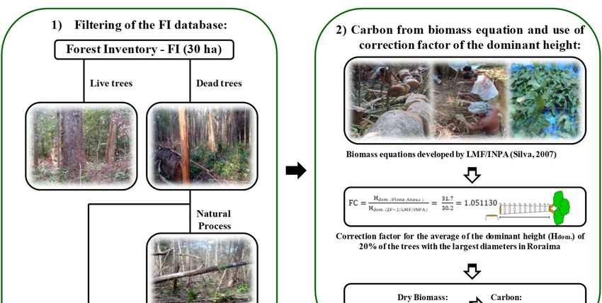
Forests 2019, 10, 61                                                                                                         3 of 22
Forests 2019, 10, x FOR PEER REVIEW                                                                                         3 of 22

     The
      The forest
            forest Anaua
                    Anaua was    was legally
                                         legally declared
                                                    declared aa national
                                                                    national forest
                                                                               forest inin 2005,
                                                                                             2005, and
                                                                                                     and itit covers
                                                                                                              covers anan area
                                                                                                                           area of
                                                                                                                                 of
approximately     2600   km   2 . It is an area protected by law [26] within the category of the sustainable use of
approximately 2600 km². It is an area protected by law [26] within the category of the sustainable use
natural
of naturalresources,   whichwhich
               resources,        allowsallowsfor the for
                                                      legalthe
                                                             exploitation   of timber by
                                                                 legal exploitation       of Sustainable
                                                                                               timber by Forest      Management
                                                                                                              Sustainable   Forest
Plans   (PMFS)    after  approval        of   the  Management        Plan.  In  2018,  this
Management Plans (PMFS) after approval of the Management Plan. In 2018, this Management Plan  Management         Plan had  not  yet
been  completed.     Consequently,           illegal selective    logging  and    associated     forest
had not yet been completed. Consequently, illegal selective logging and associated forest fires has     fires has  been  observed
more   intensely in
been observed         situ intensely
                   more     in the eastern        region,
                                            in situ  in thedue   to its proximity
                                                              eastern   region, due  to to
                                                                                        agrarian     reform settlement
                                                                                            its proximity     to agrarianprojects,
                                                                                                                           reform
private  rural  properties,      rural    roads,   and   a federal   highway     (BR-174).
settlement projects, private rural properties, rural roads, and a federal highway (BR-174).
     The
      The history
            history of
                     of changes
                         changes in    in land
                                           land use
                                                  use and
                                                       and land
                                                             land cover,
                                                                    cover, and
                                                                           and timber
                                                                                  timber exploitation
                                                                                           exploitation in  in southern
                                                                                                               southern Roraima
                                                                                                                          Roraima
(mosaic    area:  66,928    km   2 ; State of Roraima: 224,396.8 km2 ) was spatially evaluated between 2011
(mosaic area: 66,928 km²; State of Roraima: 224,396.8 km²) was spatially evaluated between 2011 and
and
20162016
      by theby the  Deforestation
                Deforestation             Authorizations
                                      Authorizations           (ADs
                                                            (ADs     ==  103)and
                                                                       103)   andSustainable
                                                                                     SustainableForest
                                                                                                     Forest Management
                                                                                                              Management Plans
                                                                                                                             Plans
(PMFSs
(PMFSs =   = 4)
             4) issued
                issued by by the
                               the environmental
                                      environmental agencies:
                                                            agencies: the
                                                                        the State
                                                                             State Foundation
                                                                                     Foundation for   for the
                                                                                                          the Environment
                                                                                                                Environment andand
Water   Resources    of  Roraima        (FEMARH)         and   the  Brazilian   Institute
Water Resources of Roraima (FEMARH) and the Brazilian Institute of Environment and Renewable of Environment       and Renewable
Natural
Natural Resources
           Resources(IBAMA)
                          (IBAMA)     [27].    Monitoring
                                           [27].   Monitoring of forest fires by
                                                                   of forest  firestheby
                                                                                       National     InstituteInstitute
                                                                                           the National        for Spacefor
                                                                                                                         Research
                                                                                                                             Space
(INPE)
Research from   January
            (INPE)   fromtoJanuary
                               March in     to 2016
                                                Marchdemonstrated       the penetration
                                                        in 2016 demonstrated                 of fire in Flona
                                                                                     the penetration      of fireAnauá  (Figure
                                                                                                                  in Flona  Anauá1,
see Supplementary        Materials:       Figure
(Figure 1, see Supplementary Materials: Figure S1). S1).

2.2.
2.2. Data
      Data Collection
            Collection
      A
      A forest
         forest inventory
                 inventory (FI)
                             (FI) was
                                  was carried
                                       carried out
                                                 out from
                                                     from 2014
                                                            2014 to
                                                                 to 2017
                                                                    2017 by
                                                                         by aa team
                                                                               team from
                                                                                     from the
                                                                                            the Forest
                                                                                                Forest Management
                                                                                                        Management
Laboratory
Laboratory of the National Institute of Amazonian Research (LMF/INPA) (Figure 2). A total
               of  the National   Institute  of Amazonian       Research  (LMF/INPA)      (Figure   2). A total of
                                                                                                                of 120
                                                                                                                    120
plots  of 0.25  ha  (30 ha total) were  installed.   We  measured   the diameter  at  breast  height
plots of 0.25 ha (30 ha total) were installed. We measured the diameter at breast height (DBH ≥ 10 cm)(DBH   ≥  10  cm)
of
of trees
    treesinintransitional
              transitionalecosystems,
                             ecosystems, ororecotones
                                                ecotones(LOt),  between
                                                           (LOt),        forested
                                                                   between        shade-loving
                                                                             forested              campinarana
                                                                                        shade-loving    campinarana(Ld)
and   dense-canopy      rainforest, submontane      (Ds), within  Flona Anauá,   and   classified
(Ld) and dense-canopy rainforest, submontane (Ds), within Flona Anauá, and classified them        them   according   to
the  Brazilian
according     to Institute of Geography
                  the Brazilian   Institute and   Statistics (IBGE)
                                             of Geography           [28]. The (IBGE)
                                                               and Statistics  ecotones[28].
                                                                                          referThe
                                                                                                to regions
                                                                                                    ecotonesof refer
                                                                                                               contact
                                                                                                                     to
between     two  different  ecosystems.
regions of contact between two different ecosystems.

                       (a)                                      (b)                                        (c)

                       (d)                                      (e)                                        (f)
      Figure 2. Forest inventory (FI) in Flona Anauá, northern Amazonia of Brazil: (a) Installation of plots
      Figure
      (0.25 ha)2.with
                  Forest   inventoryand
                        a compass      (FI)metric
                                            in Flona   Anauá,
                                                   tape;         northern Amazonia
                                                          (b) Measurement              of Brazil:of
                                                                              of the diameters     (a)trees
                                                                                                        Installation
                                                                                                            at breastofheight
                                                                                                                        plots
      (0.25 ha)
      (DBH   ≥ 10 with
                    cm);a (c)
                          compass    and of
                              Collection   metric   tape; (b) for
                                              tree branches   Measurement     of the diameters
                                                                  botanical identification;       of trees
                                                                                            (d) The    use ofat“peconha”
                                                                                                                breast height
                                                                                                                           for
      (DBH ≥collection;
      branch    10 cm); (c)(e)Collection of tree
                                 Measuring     the branches
                                                   diametersfor   botanical
                                                               (calipers:   identification;
                                                                           Haglöf)           (d) The
                                                                                   and lengths         use of "peconha"
                                                                                                  or heights               for
                                                                                                                (metric tape)
      branch
      of dead collection;    (e) Measuring
                trees (naturally               the diameters
                                   fallen, illegally  exploited,(calipers: Haglӧf)
                                                                  and affected  by and  lengths
                                                                                   forest fires); or
                                                                                                  (f) heights   (metric tape)
                                                                                                       Georeferencing    of FI
      of dead
      plots andtrees
                  trees(naturally
                         positions.fallen, illegally exploited, and affected by forest fires); (f) Georeferencing of
      FI plots and trees positions.

     The vegetation cover map from Brazilian Institute of Geography and Statistics - IBGE
(https://portaldemapas.ibge.gov.br/; scale of 1:250,000) was used in FI planning (Figure 3). The
Illegal Selective Logging and Forest Fires in the Northern Brazilian Amazon - MDPI
Forests 2019, 10, 61                                                                                                4 of 22

ForestsThe
        2019,vegetation
              10, x FOR PEERcover   map from Brazilian Institute of Geography and Statistics - IBGE (https:
                               REVIEW                                                                               4 of 22
//portaldemapas.ibge.gov.br/; scale of 1:250,000) was used in FI planning (Figure 3). The primary
primary    units
units of the         of the conglomerates
                conglomerates                 were randomly
                                    were randomly      installed installed
                                                                  within the within  the areas
                                                                               ecotone    ecotone   areas
                                                                                                (LOt),     (LOt),
                                                                                                        from       from a
                                                                                                               a mapped
mapped polygon
polygon     vector based vectoronbased
                                  Landsaton Landsat    8 (OLI) satellite
                                             8 (OLI) satellite   images. images.
                                                                            This areaThis  area covers
                                                                                        covers           approximately
                                                                                                 approximately      76,681
76,681
ha (767ha      2 ), occupying
          km(767      km²), occupying
                                 29% of the29%total
                                                of the  total
                                                     area      area of
                                                          of Flona      FlonaFour
                                                                     Anauá.     Anauá.   Four conglomerates
                                                                                     conglomerates                 with a
                                                                                                        with a standard
standard
“cross”      "cross"
          format         format containing
                     containing    20 plots were20 installed.
                                                    plots were    installed.
                                                               Three          Three conglomerates
                                                                      conglomerates      with differentwith
                                                                                                          formatsdifferent
                                                                                                                     were
formats
installed,were      installed, butthe
             but maintaining         maintaining    the plot's(tertiary
                                        plot’s dimensions       dimensions
                                                                        units(tertiary   unitsThe
                                                                                of 0.25 ha).    of 0.25
                                                                                                   use ofha). The
                                                                                                            0.25 hause   of
                                                                                                                     plots
0.25  ha  plots    has   been  recommended       for forest  inventories   in tropical  ecosystems,
has been recommended for forest inventories in tropical ecosystems, due to a greater accuracy in        due  to a greater
accuracy
representing in representing       the forest
                  the forest structure         structure
                                          [29–31].         [29–31].
                                                    An analysis       An analysis
                                                                  of variance  (ANOVA)of variance    (ANOVA)
                                                                                            for the density       fortrees
                                                                                                              of the   the
density
(trees     −1 )the
       ·haof     andtrees   (trees·ha
                       the forest     −1) and the forest−carbon
                                  carbon   stock (Mg·ha 1 ) established
                                                                    stock (Mg·ha    −1) established that there are no
                                                                            that there  are no requirements (p > 0.05)
requirements
for a stratified(p     > 0.05) for
                     sampling       a stratified
                                 design           sampling
                                          across the          design across
                                                      two ecosystems          the two
                                                                         (Forested      ecosystemscampinarana
                                                                                     shade-loving      (Forested shade-
                                                                                                                      (Ld)
loving   campinarana
and dense-canopy            (Ld) and submontane
                          rainforest,  dense-canopy     rainforest, submontane (Ds)).
                                                      (Ds)).

      Figure 3.
      Figure      Forest inventory
              3. Forest  inventory (FI)
                                   (FI) done
                                        done by
                                              by sampling
                                                 sampling inin conglomerates
                                                               conglomerates (standard
                                                                              (standard “cross”  format) of
                                                                                         "cross" format)    of Flona
                                                                                                               Flona
      Anauá    in the northern Brazilian  Amazon.    Vegetation  cover  map
      Anauá in the northern Brazilian Amazon. Vegetation cover map from IBGEfrom  IBGE  (https://portaldemapas.
      ibge.gov.br/) with transparency (70%)
      (https://portaldemapas.ibge.gov.br/)     withoftransparency
                                                      image by Landsat    8 (OLI)
                                                                   (70%) of imagefrom    the period
                                                                                    by Landsat  8 (OLI)01/10/2017.
                                                                                                           from the
      Legend:    Forested  areas with  large trees  [28]: Dense-canopy   rainforest, submontane     (Ds);
      period 01/10/2017. Legend: Forested areas with large trees [28]: Dense-canopy rainforest, submontane Forested
      shade-loving    campinarana   (Ld); Ecotones   (LOt), among  others. Non-forest  areas with  the
      (Ds); Forested shade-loving campinarana (Ld); Ecotones (LOt), among others. Non-forest areas with presence  of
      small  trees, shrubs, herbs  and  grasses [28]: Grassy–woody     shade-loving  campinarana     (Lg);
      the presence of small trees, shrubs, herbs and grasses [28]: Grassy–woody shade-loving campinarana   Shrubby
      shade-loving
      (Lg); Shrubbycampinarana
                       shade-loving(Lb);  Treed shade-loving
                                     campinarana    (Lb); Treedcampinarana
                                                                 shade-loving(La), among others.
                                                                              campinarana    (La), among others.

     In the timber measurement (TM) stage, we measured the diameters and heights of 171 dead trees
     In the timber measurement (TM) stage, we measured the diameters and heights of 171 dead trees
(naturally fallen, illegally exploited, and affected by forest fires) (Figure 4). The selection of trees was
based on the results from the forest inventory, observing the classical pattern of the negative exponential
based on the results from the forest inventory, observing the classical pattern of the negative
distribution of tree diameters in native forests in the Amazon [32–34]. Species identifications were
exponential distribution of tree diameters in native forests in the Amazon [32–34]. Species
confirmed by the Herbarium of INPA (see Supplementary Materials: Table S1). DBH and dominant
identifications were confirmed by the Herbarium of INPA (see Supplementary Materials: Table S1).
height data were used to estimate forest carbon stocks from biomass equations.
DBH and dominant height data were used to estimate forest carbon stocks from biomass equations.
Illegal Selective Logging and Forest Fires in the Northern Brazilian Amazon - MDPI
Forests
Forests   2019,
        2019, 10,10,
                  61x FOR PEER REVIEW                                                                                                                                                                                                                        5 5ofof2222

                                         350
                                                309                                                                                               50
                                                                                                  Forest Inventory - FI (30 ha)                                                                                                         Illegally exploited
                                         300
    Density of trees - FI (trees ha-1)

                                                                                                                                                                                                                                        Fallen naturally
                                                                                                                                                  40

                                                                                                                                           Density of dead trees - TM
                                         250                                                                                                                                                                                            Affected by forest
                                                                                                                                                                        32
                                                                                                                                                                                                                                        fires
                                                                                                                                                  30                              28
                                         200
                                                                                                                                                                          23

                                         150
                                                                                                                                                  20
                                                        107
                                                                                                                                                                                 13
                                         100                                                                                                                                              10
                                                                                                                                                  10                                                                  8
                                                                                                                                                                                                  7       7
                                                                                                                                                                                          5           5                         5         5      5
                                                                 39                                                                                                                           3                                                         33
                                          50                                                                                                                                          2                       2           2
                                                                         17                                                                                                  1                                    1                 1
                                                                                  8       4       3        1        1        1                             0
                                           0                                                                                                                            10 < 2020 < 3030 < 4040 < 5050 < 6060 < 7070 < 8080 < 90 90 < ≥ 100
                                               10 < 20 20 < 30 30 < 40 40 < 50 50 < 60 60 < 70 70 < 80 80 < 90 90 < 100    ≥ 100                                                              DBH classes (cm)                   100
                                                                           DBH classes (cm)

                                                                                        (a)                                                                                                                                   (b)
                          Figure 4. Densities of trees on Flona Anauá, southern Roraima: (a) Mean tree density per diameter
                          class per hectare
                            Figure          in theof
                                    4. Densities   forest
                                                     treesinventory
                                                            on Flona(FI); (b) Mean
                                                                     Anauá,         deadRoraima:
                                                                               southern   tree density
                                                                                                    (a) per
                                                                                                        Meandiameter  class inper
                                                                                                               tree density    thediameter
                                                                                                                                  timber
                          measurement    (TM) in
                            class per hectare   stage:
                                                   the Illegally exploited;
                                                       forest inventory     Fallen
                                                                          (FI); (b) naturally;
                                                                                    Mean dead  Affected  by forest
                                                                                                 tree density  perfires.
                                                                                                                    diameter class in the
                                         timber measurement (TM) stage: Illegally exploited; Fallen naturally; Affected by forest fires.
2.3. Carbon from the Biomass Equation and the Use of the Correction Factor of the Dominant Height
  2.3.The
       Carbon  from
          carbon      the Biomass
                    stored  in trees Equation   and the
                                     was estimated     in Use
                                                          threeofstages.
                                                                  the Correction
                                                                          Initially,Factor  of the
                                                                                      estimates   ofDominant
                                                                                                     the total fresh
  Height (the sum of the above-ground and below-ground biomasses) were estimated from equations
biomass
developed   by the
        3002The       LMF/INPA
                  carbon  stored infor  Central
                                     trees        Amazonia
                                           was estimated    in at Manaus,
                                                               three stages.AM,    for Ds,
                                                                              Initially,    methodofdescribed
                                                                                         estimates                 by
                                                                                                        the total fresh
Silva in 2007 [30].  The  correction   factor for the average   of the dominant     height   (H
  biomass (the sum of the above-ground and below-ground biomasses) were estimated from equationsdom. ) of 20%  of the
trees with theby
  developed     largest diameters [31]
                   the LMF/INPA           were developed
                                      for Central  Amazonia  according   to the
                                                                at Manaus,      equations
                                                                              AM,    for Ds,below:
                                                                                              method described by
  Silva in 2007 [30]. The correction H
                                     factor for the average of the dominant height (Hdom.) of 20% of the
                                       dom.(Flona Anauá)    33.2
  trees with the largest diameters                        =
                            FC = [31] were developed according    = to
                                                                    1.098023
                                                                       the equations below:        (1)
                                  Hdom.(ZF−2/LMF/INPA)      30.2
                                                                                                               .(                 á)   .
                                      FC =                             =        = 1.098023                                    (1)
where FC is the correction factor of the dominant   .(     /   /height
                                                                    )        .
                                                                         in transitional   ecosystems or ecotones (LOt)
between
  where FC theisforested   shade-loving
                  the correction   factor ofcampinarana
                                               the dominant    (Ld)   and in
                                                                  height   thetransitional
                                                                                  dense-canopy     rainforest,
                                                                                              ecosystems         submontane
                                                                                                             or ecotones    (LOt)
(Ds)  on  Flona   Anauá.    H
  between the forested shade-loving
                             dom.(Flona Anauá)    is   the dominant      height    average  of  20%   of the
                                               campinarana (Ld) and the dense-canopy rainforest, submontane   largest  trees in
TM   on on
  (Ds)   Flona
            FlonaAnauá;
                    Anauá.Hdom.(ZF-2/LMF/INPA)
                             Hdom.(Flona Anauá) is theis dominant
                                                         the dominant     height
                                                                      height        average
                                                                                average       of 20%
                                                                                         of 20%        of the
                                                                                                   of the      largest
                                                                                                           largest      trees
                                                                                                                    trees  in in
                                                                                                                              TM
ZF-2/Manaus,       AM.
  on Flona Anauá; Hdom.(ZF-2/LMF/INPA) is the dominant height average of 20% of the largest trees in ZF-
      In the second
  2/Manaus,     AM. stage, we estimated the dry biomass with the use of a correction factor based upon
the water   content
        In the  secondin stage,
                         the trees
                                 wedeveloped
                                     estimated the  by the
                                                         dryLMF/INPA.
                                                              biomass with     We  applied
                                                                                 the use of aa correction
                                                                                               factor of 0.582,
                                                                                                            factorthe  average
                                                                                                                    based   upon
ofthe
   thewater
       factors   developed    for Ds  [30]  and   Ld    [31]. Finally,  the carbon    present   in the
               content in the trees developed by the LMF/INPA. We applied a factor of 0.582, the averagetrees  was  estimated
onofthe
     thebasis   of the
          factors      specificfor
                   developed     carbon   contents
                                    Ds [30]   and Ldof[31].wood,   according
                                                               Finally,           to LMF/INPA.
                                                                          the carbon    present inWe the applied
                                                                                                          trees was a factor  of
                                                                                                                      estimated
0.480%,   an  average   of the  factors  developed       for  Ds [30]  and   Ld   [35].
  on the basis of the specific carbon contents of wood, according to LMF/INPA. We applied a factor of
  0.480%, an average of the factors developed for Ds [30] and Ld [35].
2.4. Tree Mortality and Carbon Stock
  2.4.Estimations
       Tree Mortality   and
                   of the    CarboninStock
                           increase     tree mortality and the decrease in forest carbon stock were made
in three stages. In the first, the forest inventory (FI) database was used to identify dead trees that
        Estimations of the increase in tree mortality and the decrease in forest carbon stock were made
died through natural processes (naturally fallen) and dead trees affected by human process (illegally
  in three stages. In the first, the forest inventory (FI) database was used to identify dead trees that died
exploited and affected by forest fires), excluding live trees (Figure 5). Subsequently, individual tree
  through natural processes (naturally fallen) and dead trees affected by human process (illegally
carbon values were estimated from a biomass equation developed at Manaus, AM (LMF/INPA),
  exploited and affected by forest fires), excluding live trees (Figure 5). Subsequently, individual tree
using a correction factor derived from the average of the dominant height of the trees in Roraima.
  carbon values were estimated from a biomass equation developed at Manaus, AM (LMF/INPA),
Finally, we estimated the impact of illegal selective logging and forest fires on the increase of tree
  using a correction factor derived from the average of the dominant height of the trees in Roraima.
mortality, and subsequent decreases in forest carbon stock in the Flona Anauá. Mean values and
  Finally, we estimated the impact of illegal selective logging and forest fires on the increase of tree
95% confidence intervals (CI95% ) were estimated per hectare and population [36] (see Supplementary
  mortality, and subsequent decreases in forest carbon stock in the Flona Anauá. Mean values and 95%
Materials: Equations S1; method described by Soares et al. in 2011, p. 163–174)). We assumed in this
  confidence intervals (CI95%) were estimated per hectare and population [36] (see Supplementary
study that the reduction of the forest carbon stock arising through natural processes would be slow,
  Materials: Equations S1; method described by Soares et al. in 2011, p. 163–174)). We assumed in this
  study that the reduction of the forest carbon stock arising through natural processes would be slow,
Illegal Selective Logging and Forest Fires in the Northern Brazilian Amazon - MDPI
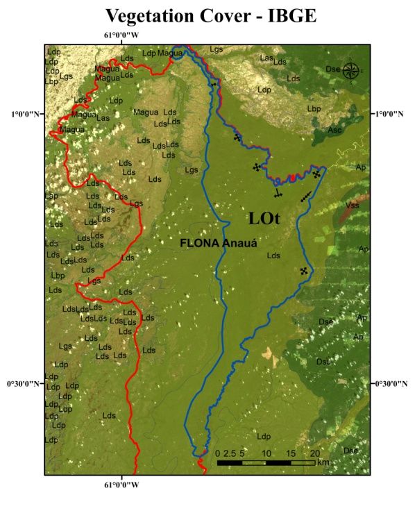
Forests 2019, 10, 61                                                                                                 6 of 22

Forests 2019, 10, x FOR PEER REVIEW                                                                                 6 of 22
changing the gas exchange of the forest ecosystem in the medium- and long-term. Dead trees that have
have naturally
naturally   fallenfallen   will keep
                    will keep   their their
                                      carboncarbon
                                               storedstored
                                                        for a for a long
                                                               long  time,time,  without
                                                                            without        considerable
                                                                                      considerable         losses
                                                                                                       losses fromfrom
                                                                                                                     the
the forest.   Trees   that have   naturally   fallen are  generally    not  removed    from    the  forest
forest. Trees that have naturally fallen are generally not removed from the forest by loggers, because     by  loggers,
because
they  has they   has low commercial
          low commercial       value, duevalue,   duedecomposition
                                            to their   to their decomposition      state. In trees
                                                                        state. In contrast,   contrast,  treesby
                                                                                                    affected   affected
                                                                                                                 illegal
by illegallogging
selective   selectiveresults
                        logging
                              in results in anloss
                                  an effective   effective  losscarbon
                                                     of forest   of forest  carbon
                                                                         stock       stock
                                                                                in the      in the short-term.
                                                                                        short-term.    These treesThese
                                                                                                                     are
trees are  immediately      extracted,  and  processed    at local  sawmills.   Forest  fires alter  the
immediately extracted, and processed at local sawmills. Forest fires alter the gas exchange of the forestgas  exchange
of the forest
ecosystem        ecosystem
              in the           in the
                      short term,      short term,
                                   reducing          reducing
                                               the forest  carbon thestock
                                                                       forest  carbon stock
                                                                            to different        to different
                                                                                          degrees,    accordingdegrees,
                                                                                                                 to fire
according    to fire
incidence [15–17].   incidence   [15–17].

      Figure 5.
      Figure 5. Flowchart
                Flowchart of  steps to
                          of steps  to obtain
                                       obtain estimates
                                              estimates of
                                                        of tree
                                                           tree mortality
                                                                mortality and
                                                                          and forest
                                                                              forest carbon
                                                                                     carbon stocks
                                                                                            stocks in
                                                                                                   in Flona
                                                                                                      Flona
      Anauá, northern
      Anauá,  northern Brazilian
                       Brazilian Amazon.
                                 Amazon.

2.5.
2.5. Mapping
     Mapping of of Illegal
                   Illegal Selective
                           SelectiveLogging
                                     Loggingand
                                             andForest
                                                 ForestFires
                                                        Fireswith
                                                              withClaslite
                                                                   Clasliteand
                                                                            andINPE/Queimadas,
                                                                                INPE/Queimadas,and
                                                                                                andRestrictions
due  to Forest Physiognomy
Restrictions due to Forest Physiognomy
      Using
      Using aa combination
                combination of   of CLASlite
                                    CLASlite [37][37] with
                                                       with INPE/Queimadas
                                                             INPE/Queimadas [38],   [38], with
                                                                                           with restriction
                                                                                                  restriction per
                                                                                                               per forest
                                                                                                                     forest
physiognomy,     we   mapped    the surface   area  or the influence   (total  area),  and  the
physiognomy, we mapped the surface area or the influence (total area), and the effective area ofeffective  area  of illegal
selective  logginglogging
illegal selective    associated   with forest
                              associated    withfires (Figures
                                                   forest        6–10). CLASlite
                                                          fires (Figures              integratesintegrates
                                                                             6–10). CLASlite       a series ofaprocesses
                                                                                                                 series of
that  take  raw  satellite imagery     and  that  produce    forest  cover   change
processes that take raw satellite imagery and that produce forest cover change images  images    [37]. These[37].
                                                                                                               processes
                                                                                                                     These
can  be summarized      thus:  (1) radiometric     calibration  and   atmospheric      correction   of
processes can be summarized thus: (1) radiometric calibration and atmospheric correction of satellite  satellite data;   (2)
cloud,  water,  and   shadow    masking;    (3) decomposition      of image    pixels   into fractional
data; (2) cloud, water, and shadow masking; (3) decomposition of image pixels into fractional surface     surface  covers;
and  (4–5)
covers;  andclassification  of the imagery
              (4–5) classification             into forest
                                     of the imagery     intocover,
                                                              forestdeforestation,     and forest
                                                                     cover, deforestation,      anddisturbance     (illegal
                                                                                                     forest disturbance
selective  logging logging
(illegal selective   in this study).
                              in this Two    scenes
                                         study).  Two(Mosaic)    of the remote
                                                        scenes (Mosaic)           sensor
                                                                             of the  remote Landsat
                                                                                               sensor8 Landsat
                                                                                                         (OLI; Path:    232;
                                                                                                                  8 (OLI;
Rows:   059–060;  area:  66,928  km  2 ; Period: 04 October 2015 to 10 January 2017) obtained from the USGS
Path: 232; Rows: 059–060; area: 66,928 km²; Period: 04 October 2015 to 10 January 2017) obtained from
website
the USGS  (https://earthexplorer.usgs.gov/)          were used
             website (https://earthexplorer.usgs.gov/)            byused
                                                               were   CLASlite    3.2 for mapping
                                                                             by CLASlite                the totalthe
                                                                                             3.2 for mapping       area   of
                                                                                                                       total
illegal selective  logging  in  southern    Roraima,   Brazil  (Figure
area of illegal selective logging in southern Roraima, Brazil (Figure 6).6).
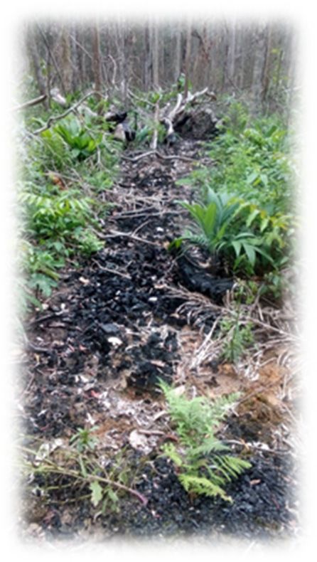
Illegal Selective Logging and Forest Fires in the Northern Brazilian Amazon - MDPI
Forests
Forests   2019,
        2019, 10,10,
                  61x FOR PEER REVIEW                                                                                   77ofof2222

                            (a)                                                             (b)

                             (c)                                                            (d)
      Figure 6. Flowchart of the steps with CLASlite for mapping illegal selective logging in southern
      Roraima,
        Figure 6.Brazil:  (a) Radiometric
                   Flowchart               calibration
                                 of the steps          and atmospheric
                                               with CLASlite            correction
                                                              for mapping    illegalofselective
                                                                                       the satellite  data in
                                                                                                 logging   (including
                                                                                                               southern
      cloud,  water,
        Roraima,      and shadow
                  Brazil:            masking);
                            (a) Radiometric     (b) Decomposition
                                            calibration            of image
                                                        and atmospheric      pixels into
                                                                         correction        fractional
                                                                                      of the  satellitesurface  covers
                                                                                                        data (including
      (photosynthetic    vegetation—PV;    non-photosynthetic  vegetation—NPV      and   bare  substrate—BARE);
        cloud, water, and shadow masking); (b) Decomposition of image pixels into fractional surface covers         (c)
      Forest  cover  classification; (d) Forest  change detection (deforestation  and   illegal selective
        (photosynthetic vegetation—PV; non-photosynthetic vegetation—NPV and bare substrate—BARE);         logging  or
      forest disturbance).
        (c) Forest cover classification; (d) Forest change detection (deforestation and illegal selective logging
       or forest disturbance).
      CLASlite mapped without discrimination the illegal selective logging as any type of intensity of
forest disturbance,
        CLASlite mapped differing  only discrimination
                              without    from deforestation     (clear cut).
                                                           the illegal         CLASlite
                                                                         selective    logginghasasitsany
                                                                                                      own    spectral
                                                                                                          type         library,of
                                                                                                                of intensity
soforest
    we created    one  restriction  by  forest  physiognomy,     derived    of  the  vegetation     cover
         disturbance, differing only from deforestation (clear cut). CLASlite has its own spectral library, map   from   IBGE
(Scale  1:250.000;  https://portaldemapas.ibge.gov.br/),           to perform     the   overlapping
  so we created one restriction by forest physiognomy, derived of the vegetation cover map from IBGE    of CLASlite    results
(Figure
  (Scale 7a).  Thus, https://portaldemapas.ibge.gov.br/),
          1:250.000;  we assume that in forest areas (large to      trees), illegal
                                                                       perform     the selective  logging
                                                                                         overlapping         was quantified
                                                                                                          of CLASlite    results
as(Figure
    being associated
            7a). Thus, we assume that in forest areas (large trees), illegal selective logging (Ds),
                         or not with   forest  fires [28]: Dense-canopy       rainforest,     submontane             forested
                                                                                                               was quantified
shade-loving     campinarana
  as being associated     or not(Ld),
                                  withtransitional
                                         forest fires ecosystems     or ecotones
                                                       [28]: Dense-canopy            (LOt), among
                                                                                 rainforest,            others (Figure
                                                                                               submontane                 7b,c).
                                                                                                                 (Ds), forested
Inshade-loving
   non-forested campinarana
                    areas, with the(Ld),
                                      presence    of small  trees, shrubs,   herbs,     and  grasses,   forest
                                           transitional ecosystems or ecotones (LOt), among others (Figure      disturbances
were   quantified
  7b,c).             as beingareas,
          In non-forested      probably
                                      withassociated
                                             the presencewith of
                                                               forest  fires,
                                                                   small       without
                                                                           trees,   shrubs,illegal   selective
                                                                                                herbs,          logging forest
                                                                                                         and grasses,      [28].
Non-forested
  disturbances areas     were represented
                   were quantified    as beingby     grassy–woody
                                                  probably    associatedshade-loving
                                                                           with forest campinarana
                                                                                            fires, without (Lg);
                                                                                                              illegalshrubby
                                                                                                                      selective
shade-loving      campinarana     (Lb);  treed   shade-loving    campinarana        (La),
  logging [28]. Non-forested areas were represented by grassy–woody shade-loving campinaranaamong     others   (Figure 7b,d).
                                                                                                                            (Lg);
Both  forestshade-loving
  shrubby     disturbancescampinarana
                              were confirmed (Lb);bytreed
                                                      validations    in field
                                                           shade-loving        (in situ) observations.
                                                                            campinarana         (La), among others (Figure
 7b,d). Both forest disturbances were confirmed by validations in field (in situ) observations.
Illegal Selective Logging and Forest Fires in the Northern Brazilian Amazon - MDPI
Forests 2019,
   Forests    10,10,
           2019, 61 x FOR PEER REVIEW                                                                                    8 of 22 22
                                                                                                                           8 of

                             (a)                                                             (b)

                             (c)                                                             (d)
      Figure 7. Restriction by forest physiognomy (forest area/non-forest area) derived from the vegetation
      cover map7.from
        Figure           IBGE to
                   Restriction   byperform   the overlapping
                                     forest physiognomy        of CLASlite
                                                          (forest           results:area)
                                                                   area/non-forest   (a) Cover  map
                                                                                          derived    from
                                                                                                  from  theIBGE; (b)
                                                                                                            vegetation
      Restriction
        cover map  byfrom
                       forestIBGE
                               phytophysiognomy     (forest areas/non-forest
                                   to perform the overlapping                 areas); (c)
                                                                  of CLASlite results: (a)Overlapping   of CLASlite
                                                                                           Cover map from     IBGE; (b)
      results in forest
        Restriction   byareas:
                          forest forest disturbances and
                                  phytophysiognomy         deforestation;
                                                       (forest            (d) Overlapping
                                                               areas/non-forest               of CLASlite results
                                                                                areas); (c) Overlapping           in
                                                                                                           of CLASlite
      non-forest
        results inareas:
                    forestforests
                            areas:disturbances   and deforestation.
                                    forest disturbances  and deforestation; (d) Overlapping of CLASlite results in
         non-forest areas: forests disturbances and deforestation.
       In this study, we considered all selective logging from illegal sources for three reasons (Figure 8):
(a) Within     the study,
          In this   Flona Anauá      area, anyall
                             we considered       selective logging
                                                   selective  logging  is from
                                                                          illegal,  because
                                                                                 illegal      this conservation
                                                                                         sources    for three reasonsunit (Figure
                                                                                                                           does
not   yet   have   an   approved     Management       Plan   [26];  (b)  Outside     the  Flona    Anauá
   8): (a) Within the Flona Anauá area, any selective logging is illegal, because this conservation unit   area   in  agrarian
reform
   does notsettlement
                yet haveprojects     and private
                            an approved             rural properties
                                            Management       Plan [26]; with     ADs, this
                                                                           (b) Outside    the environmental
                                                                                               Flona Anauá area  license    was
                                                                                                                      in agrarian
not   used   for  deforestation    (clear cut)  for cattle ranching     or   agriculture   implementation
   reform settlement projects and private rural properties with ADs, this environmental license was not        (as  registered
in used
    ADs),forbut    spatial patterns
                deforestation    (clearcharacteristic
                                         cut) for cattleof   the illegal
                                                          ranching           selective logging
                                                                       or agriculture              were still(as
                                                                                          implementation       observed;
                                                                                                                   registered (c)in
Outside
   ADs), butthe Flona
                 spatialAnauá     area
                           patterns     in PMFSs, observed
                                      characteristic            deforestation
                                                     of the illegal                 was associated
                                                                      selective logging     were stillwith  illegal (c)
                                                                                                        observed;     selective
                                                                                                                          Outside
logging     in  spatial   patterns   that did  not  characterize     either   legal  selective   logging
   the Flona Anauá area in PMFSs, observed deforestation was associated with illegal selective logging    or  RIL,    and  they
contained
   in spatial  associated
                 patterns deforestation.      The findingeither
                            that did not characterize      of these   illegal
                                                                   legal        activities
                                                                            selective      was confirmed
                                                                                       logging    or RIL, andbythey     (in situ)
                                                                                                                 fieldcontained
observations       of  a  complete    absence   of RIL  techniques      that   are  obligatory
   associated deforestation. The finding of these illegal activities was confirmed by field (in   when   sustainable      forest
                                                                                                                              situ)
management         is authorized     by  competent    environmental         agencies   in  Brazil.
   observations of a complete absence of RIL techniques that are obligatory when sustainable forest We  detected     extensive
forest   degradation,
   management              excluding the
                      is authorized        possibility of
                                        by competent        the selective extraction
                                                         environmental         agencies in of Brazil.
                                                                                              legal timber.  We performed
                                                                                                      We detected       extensive
anforest
     accuracy    assessment     of  the  mapping    by  CLASlite     per-control     samples    (CS
            degradation, excluding the possibility of the selective extraction of legal timber. We   = 400 total;  validation
                                                                                                                      performed
in an
    situ)  (Figureassessment
        accuracy     8d) by calculating      the errorby
                                   of the mapping       matrix,   andper-control
                                                           CLASlite      the generalsamples
                                                                                        hits of the(CSuser (Producer),
                                                                                                       = 400                and
                                                                                                              total; validation
Kappa     index
   in situ)       or Kappa
              (Figure    8d) bycoefficient
                                 calculating[39].
                                               the error matrix, and the general hits of the user (Producer), and
  Kappa index or Kappa coefficient [39].
Illegal Selective Logging and Forest Fires in the Northern Brazilian Amazon - MDPI
Forests
Forests    2019,
        2019, 10, 10,
                  61 x FOR PEER REVIEW                                                                                 9 of
                                                                                                                     9 of 22 22

                               (a)                                                       (b)

                               (c)                                                       (d)
     Figure   8. Analysis
         Figure            of of
                 8. Analysis  thethe
                                  spatial pattern
                                     spatial      of of
                                             pattern illegal selective
                                                        illegal         logging
                                                                selective       in in
                                                                          logging  thethe
                                                                                       northern  Brazilian
                                                                                          northern         Amazon:
                                                                                                   Brazilian Amazon:
     (a)(a)
          Within  the Flona  Anauá;   (b) Outside  the Flona  Anauá    area in deforestation  authorizations
             Within the Flona Anauá; (b) Outside the Flona Anauá area in deforestation authorizations        (ADs);
                                                                                                                (ADs);
     (c) (c)
          Outside
             Outsidethethe
                        Flona  Anauá
                           Flona  Anauá area in Sustainable
                                           area in SustainableForest  Management
                                                                 Forest   Management  Plans (PMFSs);
                                                                                         Plans        (d)(d)
                                                                                               (PMFSs);    Accuracy
                                                                                                             Accuracy
     assessment
         assessmentof the  mapping
                      of the mapping performed
                                        performedby by
                                                    CLASlite
                                                        CLASliteperper
                                                                    CS CS
                                                                        (Landsat  8/OLI;
                                                                           (Landsat       Period:
                                                                                     8/OLI;       1010
                                                                                             Period: January  2017).
                                                                                                        January 2017).

     WeWe identified
              identifiedthethe
                             locations
                                locations of of
                                             fires  onon
                                                fires   a monthly
                                                           a monthly basis
                                                                        basis(burning
                                                                                 (burningspots  = 76,018)
                                                                                            spots   = 76,018) bybyusing  thethe
                                                                                                                     using
program    INPE/Queimadas           [38]  for  the  State  of Roraima    (area:    224,300.8  km  2 ; period: Period: 04
   program INPE/Queimadas [38] for the State of Roraima (area: 224,300.8 km²; period: Period: 04
October
   October2015
             2015 to to
                      0404
                         January
                            January 2017;
                                      2017; and
                                              and satellites
                                                    satellitesAqua
                                                               Aquaand,and,Terra,
                                                                              Terra,GOES-13,
                                                                                      GOES-13,NOAA-15,
                                                                                                   NOAA-15NOAA-18,, NOAA-18,
NOAA-19,       NPP)     for   generating     the   annual    kernel   density     map   after
   NOAA-19, NPP) for generating the annual kernel density map after several tests (burning     several      tests  (burning
                                                                                                                       spots =
spots  = 68,296;   Period:   04 January    2016  to 04  January  2017;  cell  size: 0.02 (6.25 km   2 ); search radius: 0.1;
   68,296; Period: 04 January 2016 to 04 January 2017; cell size: 0.02 (6.25 km²); search radius: 0.1; mask:
mask:
   StateState  of Roraima;
         of Roraima;          satellites:
                          satellites:     Aqua,
                                      Aqua,        Terra,
                                               Terra,     GOES-13,
                                                       GOES-13,       NOAA-15,
                                                                   NOAA-15           NOAA-18,NOAA-19,
                                                                                  , NOAA-18,      NOAA-19,NPP),   NPP), and
                                                                                                                        and to
to determine
   determine thethe surface
                      surface area
                               area or
                                     or influence    (total area) of forests   fires (Figure
                                        influence (total area) of forests fires (Figure 9).   9).
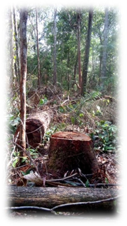
Illegal Selective Logging and Forest Fires in the Northern Brazilian Amazon - MDPI
Forests
Forests   2019,
        2019, 10,10,
                  61x FOR PEER REVIEW                                                                                    1010ofof2222

               (a)                          (b)                                 (c)                          (d)

               (e)                          (f)                                  (g)                         (h)

                (i)                         (j)                                  (k)                         (l)

               (m)                          (n)                                  (o)                         (p)
     Figure 9. Monthly estimates and annual density of forest fires in the State of Roraima: (a) October 2015;
     (b)Figure  9. Monthly
         November            estimates
                     2015; (c)  December and2015;
                                               annual   density of
                                                   (d) January      forest
                                                                 2016;     fires in the
                                                                       (e) February        State
                                                                                        2016;  (f)of  Roraima:
                                                                                                   March   2016;(a)
                                                                                                                 (g)October
                                                                                                                     April
       2015;
     2016; (h)(b) November
                May  2016; (i) 2015; (c) December
                               June 2016;            2015;(k)
                                           (j) July 2016;   (d)August
                                                                January2016;
                                                                          2016;(l)(e) February2016;
                                                                                   September      2016;(m)
                                                                                                        (f) March
                                                                                                            October 2016; (g)
                                                                                                                      2016;
     (n)April 2016; (h)
         November       May(o)
                     2016;    2016; (i) June2016;
                                December     2016;(p)
                                                    (j) Annual
                                                        July 2016; (k) August
                                                                 density,         2016; (l)
                                                                          2016/2017.        September
                                                                                         Burning     spots2016;
                                                                                                           were(m)  October
                                                                                                                 obtained
       2016;
     from  the(n)  November
                program         2016; (o) December
                         INPE/Queimadas                 2016; (p) Annual density, 2016/2017. Burning spots were
                                                (http://www.inpe.br/queimadas/portal).
       obtained from the program INPE/Queimadas (http://www.inpe.br/queimadas/portal).
Forests 2019, 10, 61                                                                                                     11 of 22
Forests 2019, 10, x FOR PEER REVIEW                                                                                     11 of 22

     The fire
           fireincidence
                 incidenceis aisreflection of the density
                                   a reflection   of the of  fires mapped
                                                           density  of firesby mapped
                                                                               INPE/Queimadas,     accumulated
                                                                                        by INPE/Queimadas,
in each region,
accumulated     incalculated
                   each region, by the   kernel density
                                    calculated           map (see
                                                by the kernel       Supplementary
                                                                 density             Materials: Equations
                                                                          map (see Supplementary            S2).
                                                                                                      Materials:
The  density
Equations   S2).ofThe
                    thedensity
                         burning     spots
                                 of the     was spots
                                        burning   classified  as: Absent,
                                                        was classified       Very low,
                                                                       as: Absent, VeryLow,    Moderate–Low,
                                                                                         low, Low,   Moderate–
Moderate–Medium,
Low, Moderate–Medium,    Moderate–High,
                                Moderate–High,High,High,
                                                     HighHigh
                                                            Intense, and and
                                                                 Intense,  VeryVery
                                                                                High, thereby
                                                                                     High,       combining
                                                                                            thereby         the
                                                                                                     combining
information    generated    by   CLASlite   with   INPE/Queimadas,       in order to map
the information generated by CLASlite with INPE/Queimadas, in order to map the surface     the  surface area or
influence (total area) and the effective area of illegal selective logging associated with forest fires in
southern Roraima (Figure 10).

      Figure 10.
      Figure  10. Mapping
                  Mapping thethe surface
                                  surface area
                                           area or
                                                or influence
                                                   influence (total
                                                               (total area)
                                                                      area) and
                                                                            and the   effective area
                                                                                the effective   area of
                                                                                                     of illegal
                                                                                                        illegal selective
                                                                                                                selective
      logging   with  forest  fires in  southern   Roraima,    thereby   combining     the  information    generated
      logging with forest fires in southern Roraima, thereby combining the information generated by CLASlite           by
      CLASlite   with  INPE/Queimadas:       (a) The  surface   area  or influence   (kernel   density—burning
      with INPE/Queimadas: (a) The surface area or influence (kernel density—burning spots; spatial                spots;
      spatial resolution
      resolution  of 2472 of
                          m);2472   m); (b) Effective
                                (b) Effective           area resolution
                                              area (spatial   (spatial resolution
                                                                          of 30 m); of
                                                                                    (c)30  m);
                                                                                         The    (c) The
                                                                                              surface   surface
                                                                                                      area        area or
                                                                                                            or influence,
      influence,
      and         and thearea
           the effective  effective
                               withinarea
                                       andwithin
                                            outsideand  outside
                                                     Flona  Anauá.Flona Anauá.

           associationofofillegal
     The association         illegal   selective
                                    selective       logging
                                                logging    withwith
                                                                 forestforest
                                                                         fires infires
                                                                                    thisinstudy
                                                                                            this was
                                                                                                  study    was undertaken
                                                                                                       undertaken              to
                                                                                                                      to account
account
for      for two important
    two important     facts foundfactsinfound    in the
                                          the field:   (1)field: (1) we observed
                                                            we observed       that after that  after selective
                                                                                            illegal  illegal selective
                                                                                                                logginglogging
                                                                                                                          inside
inside
and    and outside
     outside          Flona Anauá,
              Flona Anauá,      some areassomewereareas  were burned,
                                                       burned,    makingmaking          it difficult
                                                                             it difficult   to trace to  trace
                                                                                                      these    these activities,
                                                                                                             activities, leaving
leaving
the      the impression
    impression    that thesethat   these
                                forest      forest
                                         fires were fires
                                                       thewere
                                                             only the
                                                                   causeonlyof cause     of this
                                                                                this forest       forest disturbance;
                                                                                               disturbance;               (2) the
                                                                                                               (2) the practice
practice
of burningof after
             burning    after the conversion
                   the conversion                      of forest
                                        of forest (illegal         (illegal
                                                              selective        selective
                                                                           logging     andlogging       and deforestation)
                                                                                              deforestation)    to pasture and to
pasture andwas
agriculture    agriculture
                  observedwas       observed
                               in several    ruralinproperties
                                                      several rural
                                                                  aroundproperties      around
                                                                             Flona Anauá,          Flona Anauá,
                                                                                                generating    large generating
                                                                                                                     forest fires,
large forest
thereby       fires, confirmation
         providing    thereby providing          confirmation
                                       of the fires                of the
                                                      identified from         fires identified from
                                                                          INPE/Queimadas.                   INPE/Queimadas.
                                                                                                     According    to these rural
According this
producers,   to these   rural producers,
                  represents                     this represents
                                 the least onerous                    the least onerous
                                                          way of undertaking                     way of undertaking
                                                                                       cattle ranching     and agriculture cattle
                                                                                                                               in
ranching
the       and agriculture in the Amazon.
    Amazon.

3. Results

3.1. Forest Inventory (FI) and Timber Measurement (TM)
     A total of 14,730 trees with DBH ≥ 10 cm were measured in the 30 hectares of plots used for the
forest inventory (FI) surveys between 2014 and 2017 in Flona Anauá, southern Roraima. The mean
Forests 2019, 10, 61                                                                                                         12 of 22

tree density was 491 ± 15 trees ha-1 (CI95% ), and the mean diameter (DBH) was 21 ± 0.3 cm (CI95% ),
with a range of 10–180 cm (Table 1). From timber measurements (TM), the mean tree diameter (DBH)
was different and ranged from 10–126 cm (Table 1). The total height (H) ranged from 8 to 54 m.
The dominant height (Hdom. ), which is defined as the average of 20% of the largest trees, ranged from
26–54 m. The correction factor for Flona Anauá based on Hdom. was estimated at FC = 1.098023.

      Table 1. Mean tree density, diameter (DBH), total height (H), and dominant height (Hdom. ) in the forest
      inventory (FI), and timber measurement (TM) in the northern Brazilian Amazon.

                                                            Forest Inventory (FI)              Timber Measurement (TM)
            Forest Phytophysiognomy 1
                                                    Density   (trees·ha−1 )   DBH (cm)    DBH (cm)       H (m)        Hdom. (m)
     LOt 2 Forested shade-loving campinarana
                                                         491 ± 15              21 ± 0.3    37 ± 5        21 ± 1         33 ± 1
  (Ld)/Dense-canopy rainforest submontane (Ds)
      1Forest phytophysiognomy classified according to IBGE (2012); 2 Transitional ecosystems or ecotones; Mean values
      and 95% confidence intervals (CI95% ).

3.2. Tree Mortality and Forest Carbon Stock
     The forest of Flona Anauá had an average tree density of 491 ± 15 trees ha−1 (CI95% ),
corresponding to a mean forest carbon stock of 157 ± 5 Mg·ha−1 , and a total C stock (LOt: 76,681 ha)
of 12.1 ± 0.4 Tg (CI95% ). Illegal selective logging and forest fires resulted in a 48% tree mortality by
human process (illegally exploited and affected by forest fires; ranging from 0 to 248 dead trees·ha−1 )
and a 3.5% reduction in carbon stock (6 ± 3 Mg·ha−1 ) (Table 2). Tree mortality arising from natural
process (naturally fallen; ranging from 0 to 124 dead trees·ha−1 ) resulted in a 53% of tree mortality
(Table 2).

      Table 2. Impacts of illegal selective logging and forest fires in tree mortality and forest carbon stock in
      the northern Brazilian Amazon.

                                                 Tree Mortality                                  Forest Carbon Stock
     Description         Density (Dead        Total Dead Trees           Percentage of    Carbon Losses           Percentage of
                          Trees·ha−1 )          in FI (30 ha)             the FI (%)       (Mg ha−1 )              the FI (%)
  Natural Process 1           21 ± 3                  638                     4.3               -                       -
  Human Process 2             19 ± 9                  575                     3.9              6±3                     3.5
          Total               40 ± 9                 1213                     8.2              6±3                     3.5
      1 Dead trees arising from natural processes (naturally fallen), where the reduction of the carbon stock will be slow,
      was not quantified in the present study; 2 dead trees arising from human processes (illegally exploited and affected
      by forest fires), where the reduction of the carbon stock was fast, changing rates of gas exchange of the forest
      ecosystem in the short-term, proportional to the intensity of illegal selective logging and fire incidence. Mean values
      and 95% confidence intervals (CI95% ).

3.3. Illegal Selective Logging and Forest Fires in the Southern Roraima
     Illegal selective logging and forest fires in forest areas were detected in 357 km2 (0.5%) of the
mosaic area and 6 km2 (0.2%) within of Flona Anauá during the period 10/04/2015 to 01/10/2017
(Figures 7c and 8a–c; Table 3). This value was equivalent to 0.8% of the surveyed area (LOt). Forest
disturbances caused by forest fires in non-forest areas totaled 34 km2 (0.1%) in the mosaic area, and 0.2
km2 (0.01%) within of Flona Anauá. Deforestation in forest areas was estimated at 796 km2 (1.2%) in
the mosaic area, and 8 km2 (0.3%) within Flona Anauá. In non-forested areas, these values were much
lower. Regions closer to roads (rural and BR-174), agrarian reform settlement projects (PA/INCRA),
and private rural properties, where farmers and loggers with Authorizations of Deforestation (ADs)
are located, were the most affected.
were much lower. Regions closer to roads (rural and BR-174), agrarian reform settlement projects
(PA/INCRA), and private rural properties, where farmers and loggers with Authorizations of
Deforestation (ADs) are located, were the most affected.

                               Table 3. Areas affected by illegal selective logging and forest fires, forest disturbances (in non-forest
Forests 2019, 10, 61                                                                                                                   13 of 22
                               areas), and deforestation in the northern Brazilian Amazon.

                                                                                                     Forest Areas (km²)                                                               Non-Forest Areas (km²)
                                Table 3. Areas affected by illegal selective logging and forest fires, forest disturbances (in non-forest
                                      Description                       Flona      Mosaic    Roraima ²       Flona     Mosaic     Roraima ²
                                areas), and deforestation in the northern
                                                               LOt ¹       Brazilian Amazon.
                                                                                             Anauá                   Area                                     (%)                 Anauá             Area                  (%)
                                                                                                         Forest Areas             (km2 )                                                     Non-Forest Areas (km2 )
  Illegal selective   logging and forest
                 Description
                                                                                  2.8               6 Flona          357Mosaic                               0.16
                                                                                                                                                              Roraima 2
                                                                                                                                                                                    -Flona               -
                                                                                                                                                                                                         Mosaic             -
                                                                                                                                                                                                                         Roraima 2
                     fires                                                         LOt 1
                                                                                                         Anauá                             Area                      (%)            Anauá                 Area              (%)
  Forest disturbances by forest fires                                             -                  -                 -                                       -                   0.2                34                  0.01
  Illegal selective logging and forest fires
               Deforestation                                                      8 2.8             8      6         796 357                                 0.350.16              0.1 -             152 -                0.07-
     Forest disturbances by forest fires                                             -                     -              -                                        -                   0.2               34                 0.01
                     Total                                                       10.8               14               1153                                    0.51                  0.3               186                  0.08
                                         Deforestation                                  8                  8                                        796              0.35             0.1                 152               0.07
                               1Transitional
                                          Total ecosystems or ecotones
                                                                   10.8   (LOt 14
                                                                                = Ld/Ds); 1153
                                                                                            2 Percentage of affected areas in the State of
                                                                                                        0.51          0.3           186        0.08
                               Roraima.
                                  1 Transitional ecosystems or ecotones (LOt = Ld/Ds); 2 Percentage of affected areas in the State of Roraima.

3.4. Fire Incidence in Roraima (2016 to 2017) and Flona Anauá
 3.4. Fire Incidence in Roraima (2016 to 2017) and Flona Anauá
      The surface area, or influence of forest fires of very high density (8,397 km²) were detected in the
south-central   region
       The surface       of or
                     area,  Roraima    during
                               influence        2016fires
                                           of forest  and 2017    (Figure
                                                            of very          11a). The(8,397
                                                                       high density     eastern  2 ) wereofdetected
                                                                                             kmregion       Flona Anauá
                                                                                                                    in the
experienced
 south-centrala region
                  very high    densityduring
                         of Roraima      of forest fires
                                                2016   and(37  km²)
                                                            2017       (Figure
                                                                   (Figure      11b),
                                                                             11a).  Thewhile  theregion
                                                                                         eastern   south-central
                                                                                                          of Flonaregion
                                                                                                                   Anauá
was   the most aaffected
 experienced               by fires
                   very high         in Roraima
                               density    of forest(2016   andkm
                                                    fires (37       2 ) (Figure
                                                                2017)    (Figure11b),
                                                                                  12). The
                                                                                       whileeffective  area of the region
                                                                                               the south-central   forest
fires
 was was    in 772affected
       the most     km² (1.2%)   of the
                            by fires     mosaic area,
                                      in Roraima    (2016and
                                                           and 8 km²
                                                                 2017)(0.3%)    within
                                                                          (Figure        Flona
                                                                                   12). The     Anauá.area of the forest
                                                                                             effective
 fires was in 772 km2 (1.2%) of the mosaic area, and 8 km2 (0.3%) within Flona Anauá.
                               60000                                                                                                                250
                                                                                             Estate of Roraima                                                                                                         FLONA Anauá
                                         49,472
                                                                                                                                                            201
                               50000
                                                                                                                       Surface or influence (Km²)
  Surface or influence (Km²)

                                                                                                                                                    200

                               40000
                                                                                                                                                    150

                               30000

                                                                                                                                                    100
                               20000                                                                                                                                        68
                                                       12,156                                                                                                                         47
                                                                                                           8,397                                     50                                             34                          37
                               10000                              6,655
                                                                               4,040                                                                                                                              15
                                                                                            2,677

                                    0                                                                                                                 0
                                        Very low        Low     Moderate -   Moderate -     High         Very High                                        Very low          Low    Moderate -    Moderate -     High       Very High
                                                                 Medium        High                                                                                                 Medium         High

                                                  Density of forest fires - Period 2016 to 2017                                                                      Density of forest fires - Period 2016 to 2017

                                                                      (a)                                                                                                                  (b)
                  Figure
               Forests       10,Surface
                       2019,11.         area REVIEW
                                 x FOR PEER  or influence of forest fires in Roraima (2016 to 2017): (a) State of Roraima; (b)14 of 22
                               Figure 11. Surface area or influence of forest fires in Roraima (2016 to 2017): (a) State of Roraima; (b)
                                Flona Anauá.
                               Flona Anauá.

                                    Figure 12. Surface area or influence of forest fires in Roraima (2016 to 2017) in the eastern region of
                                   Figure 12. Surface area or influence of forest fires in Roraima (2016 to 2017) in the eastern region of the
                                                                               the Flona Anauá.
                                   Flona Anauá.

               3.5. Accuracy Assessment of Mapping Performed by CLASlite
                   The overall accuracy (86%) and Kappa coefficient (82%) of the mapping performed by CLASlite
               were high (Table 4). The accuracy from the producer, which is the probability that the classifier
               (CLASLite algorithm) has labeled an image pixel as C1 (deforestation), when the ground truth
Forests 2019, 10, 61                                                                                                       14 of 22

3.5. Accuracy Assessment of Mapping Performed by CLASlite
     The overall accuracy (86%) and Kappa coefficient (82%) of the mapping performed by CLASlite
were high (Table 4). The accuracy from the producer, which is the probability that the classifier
(CLASLite algorithm) has labeled an image pixel as C1 (deforestation), when the ground truth identified
that deforestation had occurred at that site, was higher than C2 (illegal selective logging), but both
were considered accurate in mapping. Omission errors representing pixels that belonged to the ground
truth class (in situ), but which the classification technique by CLASlite had failed to classify into the
appropriate class, were higher for C2 (illegal selective logging) and C4 (non-forested areas).

      Table 4. Accuracy assessment of the mapping performed by CLASlite in the affected areas for illegal
      selective logging, deforestation, and forest fires in the northern Brazilian Amazon.

                                        Validation 2 (Ground Truth - In Situ)               Errors (%)            Accuracy (%)
                 Class 1
                                   C1          C2        C3        C4      Total   Commission      Omission     Producer User
                            C1     89           8        0         14       111        20                11       89            80
      CLASlite

                            C2      0          75        0          1        76         1                25       75            99
                            C3      5          12        98        2        117        16                 2       98            84
                            C4      6           5         2        83        96        14                17       83            86
                           Total   100        100       100       100       400
 Overall Accuracy = 86%
 Kappa Index = 82%
      1    C1 = Deforestation; C2 = Illegal selective logging; C3 = Forest areas; C4 = Non-forested areas; 2 Control samples.

4. Discussion
      The increased occurrence and severity of climate change has been intensified by human activities,
contributing to changes in the Earth’s surface temperature, changes in the water levels of rivers and
oceans, increased greenhouse gases emissions, and a high mortality of fauna and flora [40]. Generally,
a decrease in the variability of species’ composition and alterations of forest structure have been
observed in tropical ecosystems subjected to fires [41,42]. A study with the MODIS sensor revealed
a 59% increase in the occurrence of forest fires in the Brazilian Amazon (2000–2007), in areas where
deforestation rates were being reduced, with severe implications for programs designed to reduce
emissions from deforestation and forest degradation (REDD) [43].
      The increase in forest fires in the Amazon in recent decades is strongly related to the drought–fire
interaction, due to the high flammability of dry vegetation in the El Niño years, associated with
the indiscriminate use of fire by humans. The increase in selective logging in Amazonia [7], to the
detriment of the fall in deforestation rates (2004 to 2012) [3,44], has led to sawmills receiving an
alternative constant supply of unauthorized timber [23–25,45]. This has been possible, because it is
virtually invisible to low spatial resolution sensors (MODIS, Landsat, etc.) [7,13], and because this
illegal activity can be concealed in a criminal manner with the use of multiple indiscriminate fires,
resulting in large forest fires aimed at hindering the environmental monitoring of the origins of these
fires. Another factor that contributes to increased illegal selective logging is the large migration of
loggers and sawmills from the Brazilian states of Mato Grosso, Pará, and Rondônia, to Roraima.
Roraima has been reported as a “new gold woodland”, due to its large extent of forests, the low cost of
the land, and the low environmental control of deforestation and selective logging.
You can also read