Impacts of PNITI on Key Regional Projects - February 2021 - Palmerston North ...
←
→
Page content transcription
If your browser does not render page correctly, please read the page content below
Impacts of PNITI on Key
 Regional Projects
  February 2021

freshinfo.co.nz
Contents
1    Executive summary .................................................................................................................................................................................................................... 1
     1.1       Introduction .....................................................................................................................................................................................................................1
     1.2       Summary of Ring Road impacts by project ......................................................................................................................................................................3
     1.3       Report structure ............................................................................................................................................................................................................11
2    Regional Freight Ring Road ...................................................................................................................................................................................................... 12
     2.1       What does the Ring Road project involve? ....................................................................................................................................................................12
     2.2       What are the expected impacts of the Ring Road project? ...........................................................................................................................................14
3    PNCC Spatial Plan ..................................................................................................................................................................................................................... 22
     3.1       Catalyst projects ............................................................................................................................................................................................................22
     3.2       Central NZ Distribution Precinct ....................................................................................................................................................................................24
4    North East Industrial Zone Growth .......................................................................................................................................................................................... 25
     4.1       What does the NEIZ growth project involve? ................................................................................................................................................................25
     4.2       What are the expected impacts of the NEIZ growth project? .......................................................................................................................................25
     4.3       How are the impacts of the NEIZ growth project likely to change as a result of the Ring Road? .................................................................................26
5    KiwiRail Regional Freight Hub .................................................................................................................................................................................................. 29
     5.1       What does the KiwiRail RFH project involve? ................................................................................................................................................................29
     5.2       What are the expected impacts of the KiwiRail RFH project? .......................................................................................................................................30
     5.3       How are the impacts of the KiwiRail RFH project likely to change as a result of the Ring Road? .................................................................................33
6    Palmerston North Airport development .................................................................................................................................................................................. 37
     6.1       What do the Airport development projects involve? ....................................................................................................................................................37
     6.2       What are the expected impacts of the Airport development projects?........................................................................................................................38
     6.3       How are the impacts of the Airport development project likely to change as a result of the Ring Road? ...................................................................39
7    Longburn Industrial Area Growth ............................................................................................................................................................................................ 41
     7.1       What does the Longburn growth project involve? ........................................................................................................................................................41

freshinfo.co.nz
7.2       What are the expected impacts of the Longburn growth project? ...............................................................................................................................41
       7.3       How are the impacts of the Longburn growth project likely to change as a result of the Ring Road? .........................................................................42
8      Linton Military Camp regeneration .......................................................................................................................................................................................... 44
       8.1       What does the Linton regeneration involve? ................................................................................................................................................................44
       8.2       What are the expected impacts of the Linton regeneration projects? .........................................................................................................................45
       8.3       How are the impacts of the Linton Regeneration Project expected to change as a result of the Ring Road? ..............................................................45
9      FoodHQ transformation project .............................................................................................................................................................................................. 47
       9.1       What does the FoodHQ transformation project involve? .............................................................................................................................................47
       9.2       What are the expected impacts of the FoodHQ transformation project? ....................................................................................................................49
       9.3       How are the impacts of the FoodHQ Transformation project likely to change as a result of the Ring Road? ..............................................................52
10     Major Residential Growth Projects .......................................................................................................................................................................................... 55
       10.1      What do the residential growth projects involve? ........................................................................................................................................................55
       10.2      What are the expected impacts of the residential growth projects? ............................................................................................................................56
       10.3      How are the impacts of the residential growth projects expected to change as a result of the Ring Road? ................................................................57
11     Streets for People .................................................................................................................................................................................................................... 60
       11.1      What does Streets for People involve? .........................................................................................................................................................................60
       11.2      What are the expected impacts of Streets for People? .................................................................................................................................................61
       11.3      How are the impacts of Streets for People expected to change as a result of the Ring Road? ....................................................................................62
12     Urban Cycle Network Masterplan ............................................................................................................................................................................................ 64
       12.1      What does the Urban Cycle Network Masterplan involve? ..........................................................................................................................................64
       12.2      What are the expected impacts of the Urban Cycle Network Masterplan? ..................................................................................................................65
       12.3      How are the impacts of the Urban Cycle Network Masterplan expected to change as a result of the Ring Road? .....................................................65
Appendix 1: Detailed PNITI elements ............................................................................................................................................................................................... 67
Appendix 2: NOR PNITI Outcomes ................................................................................................................................................................................................... 69

freshinfo.co.nz
1          Executive summary
1.1        Introduction
Waka Kotahi/NZTA is developing a business case for a package of roading interventions collectively known as the Palmerston North Integrated Transport
improvement (PNITI) project. The centrepiece of PNITI is the Regional Freight Ring Road (Ring Road), which will run around the outskirts of Palmerston North,
connecting key industrial areas such as the North East Industrial Zone, the planned KiwiRail Freight Hub, Feilding and state highways to the north, and
Longburn and Linton Military Camp to the south.

The Ring Road is a critical component of Palmerston North City Council’s (PNCC) plan for growing economic prosperity and liveability in the city. By
redirecting freight vehicles around rather than through Palmerston North’s City Centre and inner-city suburbs, the Ring Road will increase transport
efficiencies, improve safety, and lift amenity values in urban areas.

The Ring Road will deliver benefits to Palmerston North both as a result of its impacts on the “business as usual” activities of households and businesses and
by enabling or enhancing major growth projects in and around the city. PNCC has commissioned Fresh Info to examine the second category of impacts.
Specifically, Fresh Info has been asked to identify, and potentially quantify, the impacts that the Ring Road is expected to have in relation to the following
major projects:

 Major projects
 •    Central NZ Distribution Hub, encompassing:
      -   North East Industrial Zone growth
      -   KiwiRail Freight Hub
      -   Airport development
 •    Longburn industrial growth
 •    Linton Army Camp
 •    Food HQ transformation
 •    Residential growth in major greenfield sites:
      -    Kakatangiata
      -    Aokautere
      -    Whakarongo
 •    Streets for People (Central City Streetscape Masterplan)
 •    Urban cycle network masterplan

NZTA’s draft PNITI Network Options Report (NOR) identifies many of these projects as factors that strengthen the case for the Ring Road, however there is
limited understanding or articulation of how the value of these projects will be affected by the Ring Road and the materiality of the Ring Road’s impacts in

freshinfo.co.nz                                                                                                                                                  1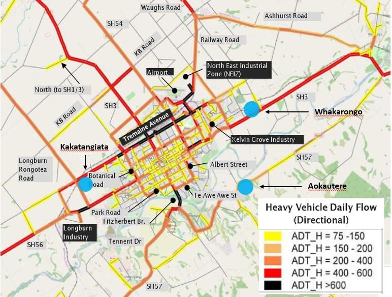
relation to them. This project seeks to fill these gaps, with the aim of ensuring that the impacts of the Ring Road and the value it will deliver regionally and
nationally are understood by decision makers.

This report provides a qualitative review of the major projects and the ways in which their outcomes are likely to be affected by the Ring Road. It adopts a
largely narrative-based approach that describes the expected impacts of each project with and without the Ring Road and provides an evaluation framework
that could be used to guide the design of a quantification process for each project.

A subsequent quantification phase could be added to estimate the value of the relevant costs and benefits of each project with and without the Ring Road,
using quantification processes that respond to the findings in this report.

Figure 1 below indicates the location of each of the major projects relative to the proposed Ring Road route. The size of the circles indicates the relative
impact of the Ring Road on each project; a larger circle reflects an expectation that the Ring Road would have a bigger effect on the value of the project
relative to a smaller circle. This is an approximate assessment only, based on the qualitative work presented in this report.

Figure 1 Ring Road route and major projects

A summary of each of the projects and the ways in which they would be impacted by the Ring Road is provided in section 1.2 below. More detailed project
overviews and evaluation frameworks are provided in the body of the report.

freshinfo.co.nz                                                                                                                                                    2
1.2       Summary of Ring Road impacts by project

1.2.1     North East Industrial Zone (NEIZ) growth
The NEIZ project involves the rezoning and development of approximately 230ha of land in the north east of the city to house large-format transport,
warehousing and logistics operations. By providing a large amount of suitable land adjacent to key existing and planned future transport connections, the
NEIZ is expected to stimulate investment by freight & distribution businesses in the region, leading to growth in the sector and associated increases in
economic activity and employment.

The Ring Road is expected to pass within 1-2 kms of the NEIZ and will provide resilient, fit-for purpose roading connections for vehicles traveling between the
NEIZ and other industrial nodes in the region. This will increase the safety and efficiency of freight movements to and from the NEIZ and reduce heavy vehicle
volumes on existing urban arterials, helping to relieve congestion and mitigating any negative traffic effects of the NEIZ’s growth. Resulting benefits will
include higher productivity for businesses based at NEIZ, which may result in further increases in investment, and improved safety and amenity for residents
living near traffic dampened arterials.

Figure 2 Main impacts of Ring Road on value of NEIZ growth project to the region

1.2.2     KiwiRail Regional Freight Hub (RFH)
KiwiRail plans to build a new, state-of-the-art, rail freight facility in the north east of the city to replace its current rail yard which is located on a growth-
constrained site in the existing urban area. The RFH site is strategically located adjacent to the NEIZ and the future planned Ring Road route, bringing the City
closer to realising its vision of a major multi-modal freight precinct in the NEIZ area. The new KiwiRail facility will be able to process significantly larger
volumes of freight than the existing railyard and will provide improved facilities for transferring freight between rail and road.

Expected outcomes of the RFH project include increased efficiency in rail freight handling, decreased reliance on the national roading network for moving
freight and an enhanced reputation for Palmerston North as a significant freight & distribution centre. Associated benefits will include productivity gains for
firms using the RFH, increased investment by freight & distribution business in the region, and reduced roading costs and CO2 emissions resulting from the
modal shift in national freight movements from road to rail. On the negative side, the RFH has the potential to exacerbate congestion on urban arterials and
will take up around 37% of the land in the NEIZ, reducing the amount of large format industrial land available for other uses.

freshinfo.co.nz                                                                                                                                                   3
Current plans have the Ring Road alignment passing within approximately 500 metres of the proposed northern entrance to the RFH and approximately 2 km
from the proposed southern entrance. The Ring Road will enable businesses to move freight safely and efficiently to and from the RFH without the need to
travel through the city centre. This will reduce congestion on urban arterials and strengthen many of the benefits delivered by the RFH, e.g. increased
productivity and investment in the freight & distribution sector, reduced roading costs and CO 2 emissions associated with the modal shift of road freight to
rail, and improved safety and amenity values in urban areas.

Figure 3 impacts of Ring Road on value of KiwiRail Regional Fright Hub (RFH) project to the region

1.2.3     Airport development
Palmerston North Airport Limited (PNAL) plans to upgrade the airport passenger terminal and develop approximately 30 ha of its non-aeronautical land for
sale or lease to other businesses. The latter includes an opportunity to develop a significant freight & logistics operation on a 5 ha parcel of land north of the
runway that borders the NEIZ.

PNAL’s development projects will increase the stock of business land available in Palmerston North, including sites that will be highly attractive to freight &
distribution businesses given their location adjacent to the airport, thus helping to boost investment in the city. The terminal upgrade will enable more air
passengers to travel through the airport, potentially resulting in higher levels of visitation, economic activity, and social connectivity.

By diverting a significant proportion of the region’s freight traffic onto the Ring Road, the PNITI project will help to relieve congestion on key airport access
routes, speeding up journey times for people using the upgraded passenger terminal or traveling to the new airport business zones. This will increase the
productivity of businesses based at the airport and reduce travel costs and CO2 emissions associated with trips to the airport. This may, in turn, stimulate
additional passenger demand, driving further increases in visitation, economic activity, and social connectivity.

freshinfo.co.nz                                                                                                                                                      4
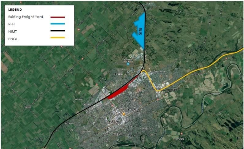
Figure 4 Main impacts of Ring Road on value of Airport development projects to the region

1.2.4     Longburn Industrial Area growth
The Council has rezoned around 85 ha of land in the Longburn area for wet industry (e.g. dairy) and general industrial uses, including freight and distribution
activities. This includes the 33 ha Braeburn Industrial Area (rezoned in 2016) which is an extension of Fonterra’s existing operations at Longburn and aims to
support Fonterra’s ongoing operational and growth needs. The proximity of Longburn to SH56, the North Island Main Trunk (NIMT) rail line and the future
Ring Road makes it a suitable area for industrial growth. By significantly increasing the stock of high-quality industrial land in the region, the Longburn growth
project is expected to stimulate investment in dairy, freight & distribution, and other sectors of the regional economy, with associated increases in economic
activity and employment.

The development opportunity at Longburn is expected to be significantly enhanced once the Ring Road comes online, providing safer and more efficient
connections with the NEIZ, KiwiRail RFH and state highways to the north and east. As a result, the Ring Road would be expected to increase the productivity
of businesses at Longburn, driving additional investment into this location, and ease congestion on key urban arterials as Longburn freight traffic migrates
away from the city centre and onto the Ring Road.

Figure 5 Main impacts of Ring Road on value of Longburn Industrial Area growth project to the region

freshinfo.co.nz                                                                                                                                                  5
1.2.5      Linton Military Camp regeneration
As part of the Government's $2.1 billion investment in defence infrastructure, Linton is scheduled for a $200m+ programme of upgrades over the next 10
years. The regeneration projects will deliver more integrated camp infrastructure, increasing the efficiency of key functions. They will also improve the
quality of the camp environment for staff, which will lift wellbeing and the ability to recruit and retain high-quality personnel, with potential positive impacts
on inward migration for the region.

The Ring Road is expected to have significant benefits for Linton Camp. The preferred PNITI programme includes a new Manawatu River crossing between
Longburn and Linton. This new connection will provide Linton traffic with a faster, safer route to the city using SH56 instead of the often-congested Tennent
Drive. It will also enable Linton military vehicle convoys to access SH1 and northern NZDF bases more directly via the Ring Road rather than their current
circuitous route via Ashhurst (or through the city), saving up to 10 mins in travel time per journey.1 The significant time and cost savings enabled by the Ring
Road will further lift the productivity of the Camp and help to reduce CO2 emissions. In adddition, shorter commutes for staff living north of the River will
generate further improvements in wellbeing and recruitment potential, reinforcing those delivered by the regeneration projects.

Figure 6 Main impacts of Ring Road on value of Linton Military Camp regeneration project to the region

1.2.6      FoodHQ transformation project
FoodHQ is a partnership between New Zealand’s largest public and private sector organisations working in New Zealand’s food science and innovation
sector.2 FoodHQ is currently seeking co-funding for a programme of work designed to enhance the effectiveness of research, development, and deployment
(RD&D) in New Zealand’s Food & Beverage (F&B) sector. A key part of the programme will be transformation of the existing F&B Science Park in Fitzherbert
into an internationally recognised F&B science and innovation ‘super campus’ that hosts top researchers and provides specialist facilities and advice to
businesses. The project involves the development of new fit-for-purpose facilities, and upgrades to the campus that will make it easier to move around.

1 According to traffic modelling provided in NOR.
2 FoodHQ partners include AgResearch, Fonterra, Massey University, Plant & Food Research, Cawthron, ESR, the New Zealand Food Safety Science and Research Centre, B.linc
(formally Lincoln Hub), The Riddet Institute and The Factory, along with local authorities in Palmerston North and Manawatū, and the Central Economic Development Agency.

freshinfo.co.nz                                                                                                                                                             6
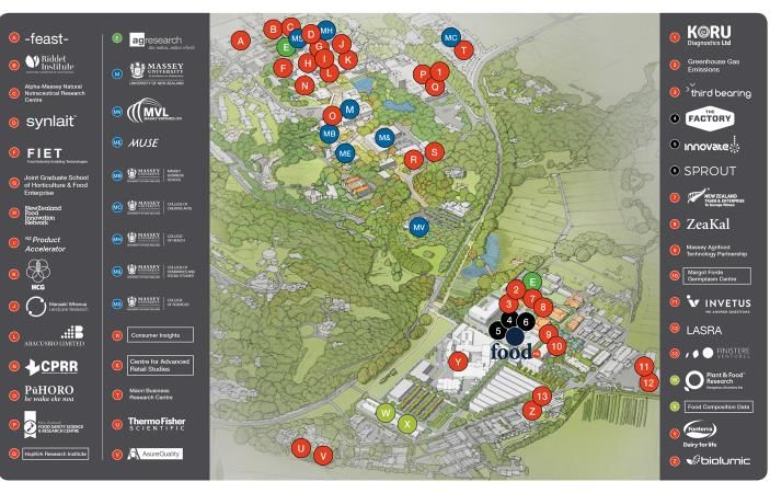
The FoodHQ transformation project is expected to lift the efficiency and effectiveness of RD&D in the New Zealand F&B sector by lifting the standard of
specialist facilities and expertise available to firms. This will lead to the development of more high-value products, more successful start-ups and higher levels
of productivity and growth in the F&B sector.

FoodHQ’s plan envisages an integrated, well-connected campus that facilitates collaboration and attracts high-quality talent. The existing Science Park is
bisected by Tennent Drive, which is a four-lane arterial with heavy traffic volumes, high vehicle speeds, limited facilities for walkers and cyclists and little
space for parking. In its current state, Tennent Drive effectively severs the campus into two distinct “islands”, creating suboptimal conditions for
collaboration.

The Ring Road will have a significant traffic dampening effect on Tennent Drive by diverting a portion of the north-south traffic currently using it to the new
downstream bridge. Traffic modelling in the NOR indicates that traffic volumes on Tennent Drive are expected to fall by around 40% as a result of the Ring
Road programme including speed reductions, or by around 25% without speed reductions. This is expected to help reduce the level of severance created by
Tennent Drive, enabling higher levels of collaboration among Science Park participants. It is also expected to ease congestion levels on Tennent Drive,
reducing the time it takes to travel between the Science Park and the city. Both outcomes will have positive impacts on park efficiencies, staff wellbeing and
recruitment potential.

Overall, the changes brought about by the Ring Road are expected to materially improve the effectiveness of the Science Park, enhancing its impacts on F&B
sector productivity and growth.

Figure 7 Main impacts of Ring Road on value of FoodHQ transformation project to the region

freshinfo.co.nz                                                                                                                                                    7
1.2.7      Major Residential growth projects
The City’s three biggest greenfield housing projects, Kakatangiata, Aokautere and Whakarongo, are together expected to meet around 50% of Palmerston
North’s new housing requirements over the next 10 years, providing approximately 5,000, 1,200 and 600 new homes respectively.3 This significant increase in
residential land stocks is expected to help curb recent growth in house prices and lift the supply of affordable housing in the city. All three housing areas have
existing state highways running through them. Pioneer Highway/SH3 runs through a portion of Kakatangiata, Napier Rd/SH3 runs through Whakarongo, and
Aokautere Drive/SH57 runs through Aokautere.

The Ring Road is expected to have the following impacts on the three housing areas:

•    it will divert significant numbers of heavy vehicles away from the three state highways, reducing noise, air pollution, etc. in the three neighbourhoods
     and making it easier and safer for residents to cross the road (reducing severance) – HCV reductions are expected to be more significant on Pioneer
     Highway/SH3 and Napier Rd/SH3 than on Aokautere Drive/SH57;4
•    it will allow Pioneer Highway/SH3 and Napier Rd/SH3 to be declassified as state highways and redeveloped as high-quality urban corridors with lower
     speed limits, better urban frontage, more access roads, etc.;
•    it will reduce congestion on the key arterials that connect the developments with the City Centre (including Pioneer Highway/SH3 and Napier Rd/SH3 in
     relation to Kakatangiata and Whakarongo, and Tennent Drive in relation to Aokautere);
•    it will provide better roading connections between Kakatangiata and key employment areas and state highways to the north and south (via the Ring
     Road itself); and
•    it will increase heavy traffic volumes on Longburn Rongotea Road, which borders Kakatangiata to its west (the impacts of which are expected to be able
     to be reduced via the use of set-backs, etc.).

Overall, the changes brought about by the Ring Road are expected to result in significant benefits for the three housing areas, including enhanced amenity
values, reduced severance and better safety outcomes. They will also increase opportunities for walking and cycling in these communities and make it easier
for residents to move around the city. The impacts of the Ring Road on Kakatangiata and Whakarongo are expected to be more significant than the impacts
on Aokautere.

3
  PNCC and developers are also working on a number of smaller residential growth projects, e.g. Ashhurst (400 new dwellings), Flygers Line (200 new dwellings) and Napier
Road (50 new dwellings), as well as assorted other infill, brownfield and medium density developments.
4
  According to traffic modelling provided in NOR.

freshinfo.co.nz                                                                                                                                                             8
Figure 8 Main impacts of Ring Road on value of major residential growth projects to the region 1.2.8 Streets for People Streets for People (the renamed Central City Streetscape Masterplan Project) is a key component of PNCC’s urban development strategy. It aims to attract more people to the City Centre by transforming it into a vibrant, pedestrian-friendly commercial and entertainment hub. Initiatives include lowering vehicle speed limits, reducing the number of carparks and carriageway widths, and providing improved ‘human scale’ and walkability conditions, e.g. reduced crossing widths, wider footpaths, more seating, accessible art, etc. Streets for People is guided by several Council strategies, including the Urban Design Strategy, the City Centre Framework and the Street Design Manual. The changes planned as part of Streets for People will reinforce the City Centre as a destination, making it a more appealing place for people to live, work and play. This will have multiple important benefits including lifting amenity values, enhancing safety and city perception, increasing the amount of time and money spent in the city by visitors, and stimulating investment by businesses. While we would expect to see these types of benefits occur with or without the Ring Road, they will be significantly weakened if the Ring Road is not built. The City Centre currently experiences large volumes of freight trucks using its streets to travel from one side of the city to the other. This creates noise, severance and safety issues that discourage people from spending time there. The desired City Centre transformation depends critically on reducing this traffic. If the project is completed without the Ring Road in place, it will fall short of the desired reduction in traffic volumes and have the unintended effect of pushing much of the traffic that is currently using inner City Centre streets out to the next ring of commercial and residential streets, creating issues for road- users in these areas. By providing an efficient alternative roading network, the Ring Road will significantly reduce the volumes of heavy vehicle and commuting through-traffic on City Centre streets while minimising any spillover impacts on surrounding areas. This will allow the Council to implement the full suite of Streets for People changes with maximum support from motorists and City Centre businesses, enabling the creation of a truly people-centric town centre. freshinfo.co.nz 9
All the benefits of Streets for People will be magnified by the traffic dampening effects of the Ring Road and the impact this will have on the City Centre
environment. The result will be bigger improvements in amenity values, safety and city pride with associated stronger gains in visitation and investment.

Figure 9 Main impacts of Ring Road on value of Streets for People to the region

1.2.9     Urban Cycle Network Masterplan
PNCC’s Cycle Action Plan sets out the aspiration for Palmerston North to be the best place to ride a bike in New Zealand. The Urban Cycle Network
Masterplan is a key element in moving the city towards this aspiration. Its initiatives include expanding the network of cycle lanes, reducing traffic speeds,
supporting school and workplace travel planning, and educating residents about sharing roads and paths safely. By making the city more conducive to cycling,
the Masterplan will have multiple important benefits including improved liveability and wellbeing for residents, reduced carbon emissions and better safety
outcomes.

Some of the potential cycle corridors being investigated by PNCC are currently used by significant volumes of freight trucks travelling from one side of the city
to the other to access key industrial areas. This creates safety issues, unwanted noise/vibrations/air pollution and competition for carriageway space, none of
which are supportive of growth in cycling.

The Ring Road will help to overcome these problems by diverting heavy vehicle traffic away from the city’s urban areas, opening up space for cycle lanes and
making the city a more attractive place for cyclists. This will enhance all the benefits of the Masterplan, accelerating cycling uptake and generating bigger
gains in amenity values and wellbeing, and bigger reductions in vehicle operating costs and CO2 emissions.

freshinfo.co.nz                                                                                                                                               10
Figure 10 Main impacts of Ring Road on value of Urban Cycle Network Masterplan to the region

1.3        Report structure
The main body of this report begins (in section 2) by reviewing the preferred programme for the Ring Road and the evaluation of its expected outcomes and
impacts provided in the NOR. Section 3 describes PNCC’s Spatial Plan, which underpins many of the projects covered in this report. Then sections 4-12
examine each of the major projects identified above, adopting the following interrogation structure in relation to each project:

•     What does the project involve?
•     What are the expected economic, social and environmental impacts of the project?
•     How are the impacts of the project expected to change as a result of the Ring Road?

freshinfo.co.nz                                                                                                                                         11
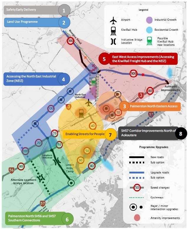
2             Regional Freight Ring Road
The Regional Freight Ring Road (Ring Road) is an integral part of NZTA’s Palmerston North Integrated Transport Improvement (PNITI) project which is a
package of interventions designed to:

•       support the freight and distribution potential of the region by providing more effective (safer and more efficient) connections between the region’s key
        industrial areas (e.g. NEIZ, Longburn and Kelvin Grove) and between these and state highways;5
•       reduce congestion and improve amenity values in urban areas, by redirecting freight and general traffic around rather than through the city;
•       assist in building the region’s resilience by creating connectivity and network diversity;
•       support existing activity and economic development opportunities at significant regional organisations, e.g. the airport, Food HQ and Linton Military
        Camp; and
•       improve the safety, efficiency and effectiveness of the transport network for Palmerston North residents.

2.1           What does the Ring Road project involve?
The preferred programme for the Ring Road identified in the NOR (Programme # 6 of the long-listed options) comprises the following connections:

•       Kairanga to Bunnythorpe
•       Bunnythorpe Bypass
•       Ashhurst to Bunnythorpe
•       No 1 Line/Rongotea Road to Longburn
•       Downstream Manawatu River crossing

5   SH3 to the northwest (Taranaki), SH1 to the north (Auckland) and to the south (Wellington), and SH2 to the east (Hawke’s Bay).

freshinfo.co.nz                                                                                                                                                12
The preferred programme is shown in Figure 126 and Figure 117 below. NZTA proposes dividing the programme up into eight stages, as shown in Figure 11.
Figure 12 Recommended Programme Figure 11 Recommended Programme Packages
Details of the key elements in each stage are provided in Table 15-1 in the NOR8, a copy of which is provided in Appendix 1.9
6 Figure 14-1, NOR p. 96.
7 Figure 14-2, NOR p. 102.
8 NOR p. 113.
9 Note that the following “do-minimum” improvements are also included in the preferred programme:
- Continued maintenance and operations
- Committed projects such as a staged rollout of Palmerston North City cycle improvements
- Ashhurst improvements
- Manawatu Gorge tie-in (est. 2024-25 opening)
freshinfo.co.nz 132.2 What are the expected impacts of the Ring Road project?
2.2.1 Modelled impacts on traffic flows
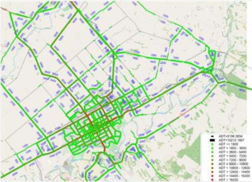
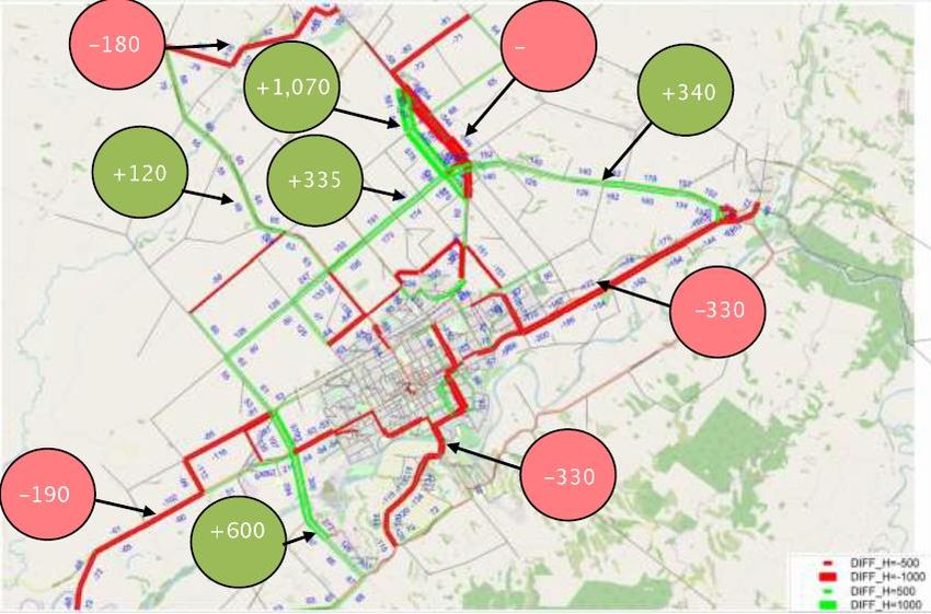
Figure 13 and Figure 14 below (from the NOR) show the results of NZTA traffic impact modelling in relation to the preferred programme for the Ring Road
(Programme 6), including corridor and intersection upgrades, new links and speed changes. Figure 13 shows the modelled impacts of the programme on daily
traffic flows for all vehicle types. Figure 14 shows the modelled impacts on daily heavy vehicle (HCV) flows. The modelled changes shown in Figure 13 and
Figure 14 represent the impacts of the programme with planned speed reductions. The next figure (Figure 15) shows modelled impacts on daily vehicle flows
(all vehicle types) without planned speed reductions. Figure 16 shows modelled base traffic flows, i.e. without the Ring Road programme, for comparison.
Fresh Info did not review the data behind the maps but was able to make some high-level observations based on a visual review of the maps. The
observations should be verified in relation to the modelling data before any reliance is placed on them.
Observations relevant to the major projects within the scope of this report are provided below.10
• Tennent Drive: The Ring Road is expected to cause significant reductions in traffic volumes on Tennent Drive (which runs through the FoodHQ Science
Park) and Fitzherbert Bridge (which links Tennent Drive with the City Centre). The modelling maps indicate:
- ~40% (3,800 vehicles) reduction in all traffic flows on Tennent Drive with speed reductions / ~25% (2,400 vehicles) reduction without speed
reductions.
- ~25% (3,900 vehicles) reduction on Fitzherbert Bridge with and without speed reductions.
- 330 fewer heavy vehicles per day on Tennent Drive and Fitzherbert Bridge (with speed reductions, although the maps suggest that the level of HCV
reduction would be similar without speed reductions).
• Napier Road/SH3: Significant impacts are also expected on this road, which runs through the Whakarongo residential growth area:
- ~30% (2,600 vehicles) reduction in traffic flows (all vehicle types) on Napier road with speed restrictions.
- slightly smaller though still significant reductions all traffic flows (all vehicle types) without speed restrictions.
- 330 fewer heavy vehicles per day on Napier Road.
• Pioneer Highway/SH3:
- Significant reductions in heavy vehicle volumes are expected on this road, which borders the Kakatangiata residential growth area to its south.
- Little change is expected in total traffic flows (all vehicle types), however.
• City Centre/other urban streets:
- With speed reductions:
- Ongoing low-cost low-risk improvements
- Improvements to connections to the new walking and cycling bridge near Massey
10 The data displayed with the maps allows estimation of differences in absolute vehicle numbers in some cases, percentage reductions in others, and no numeric estimates in
others.
freshinfo.co.nz 14▪ Significant reduction in traffic flows on Fitzherbert St leading to the City Centre.
▪ Significant reductions in traffic flows (including heavy vehicles) on Te Awe St, Albert St, Park Rd and Botanical Rd.
▪ Smaller reductions on other streets in the City Centre and wider urban area.
- Without speed reductions:
▪ Significant reduction in traffic flows on Fitzherbert St leading to the City Centre.
▪ Smaller but significant reductions on Te Awe St, Victoria Ave, Park Rd and Botanical Rd.
▪ Smaller reductions on other streets in the City Centre and wider urban area.
• Airport access routes:
- With speed reductions: significant reductions on Rangitikei St/SH3 north and Milson Line.
- Without speed reductions: significant reductions on Rangitikei St/SH3 North, Tremaine Ave between SH3 and Milson Line and North St (access road
for Tremaine Ave).
• Tremaine Ave:
- With speed reductions: The Ring Road programme is not expected to make a material difference to traffic volumes on Tremaine Ave with the
modelled speed reductions, although the NOR notes “the routes to access Tremaine Avenue may change as a result of improvements or speed
changes.” The NOR attributes the limited flow differences on Tremaine Ave itself to the fact that this road will still be a key origin and destination
for trips in its own right.
- Without speed reductions, significant reductions on Tremaine Ave between SH3 and Milson Line and on North St.
freshinfo.co.nz 15Travel times NZTA’s Table 14-1 which lists the expected outcomes of the preferred programme in 2031 (Appendix 2 to the report), estimates that the programme will have the following impacts on travel times (as relevant to the major projects): • Linton: “Journey time savings of up to 10 minutes for trips between Linton/SH57 and northern destinations” (e.g. SH1 north); • NEIZ: “Access improvements out of the NEIZ of 1-3 minutes to most key destinations.” Figure 13 Modelled difference in daily traffic flows v 2031 base (all vehicle types) with speed reductions (Programme 6):11 11 Figure 13-5, NOR p. 78. freshinfo.co.nz 16
Figure 14 Modelled difference in daily heavy vehicle traffic flows v 2031 base with speed reductions (Programme 6):12

12   Figure 13-6, NOR p. 78.

freshinfo.co.nz                                                                                                         17
Figure 15 Modelled difference in daily traffic flows (all vehicle   Figure 16 Base 2031 Average Daily Traffic1 (RHS)
types) v 2031 without speed reductions (Programme 6B)1

2.2.2     Economic, social & environmental impacts
Building on the work undertaken by NZTA and its consultants, Table 1 below identifies and briefly explains the main expected outcomes of the Ring Road
project and the resulting economic, social and environmental impacts. The changes brought about by the Ring Road (“outcomes” listed in Table 1) will impact
on the “business as usual” activities of households and businesses as well as on other major growth projects in and around the city. Likewise, the benefits
described in the Table 1 will occur both as a result of the Ring Road’s impacts on “business as usual” activities and as a result of its impacts on other major
projects. The latter category of impacts (relating to major projects) is the subject of sections 4 to 12 of this report.

freshinfo.co.nz                                                                                                                                             18
Table 1 Expected outcomes and impacts of Ring Road

 Ring Road outcomes                                         Economic impacts                                           Social & environmental impacts

 Improved connectivity and access options for users of      Reduced travel times and vehicle operating costs           Improved connectivity and reduced travel times for
 the Ring Road                                              (VOCs) for freight carriers, commuters and other users     commuters and non-work traffic, including in areas
                                                            of the Ring Road                                           PNCC intends to develop for housing
                                                            Higher productivity for businesses resulting from faster   Lower CO2 emissions resulting from reduced travel
                                                            trips and lower costs                                      times
                                                            Increased investment by new and existing businesses
                                                            as Palmerston North becomes a more attractive place
                                                            to do business

 Reduced traffic volumes on existing urban arterials as     Reduced travel times and VOCs for users of                 Enhanced liveability and amenity for people living and
 freight carriers and through traffic migrate to the Ring   decongested arterials                                      working on or near traffic-dampened arterials,
 Road                                                                                                                  including:
                                                            Higher productivity for businesses resulting from faster
                                                            trips and lower costs                                      -    improved actual and perceived safety
                                                                                                                       -    improved noise, vibrations, air quality
                                                            Increased investment by new and existing businesses
                                                            as Palmerston North becomes a more attractive place        Reduced severance between residents and
                                                            to do business                                             services/amenities (e.g. school, parks, etc.)
                                                            Higher land values for residential properties located on   Increased opportunities for walking and cycling,
                                                            or near arterials                                          resulting in improved health and wellbeing

 Reduced traffic volumes in the City centre as freight      Reduced travel times/VOCs and higher productivity for      Enhanced liveability and amenity for people spending
 carriers and through traffic migrate to Ring Road          businesses traveling via City Centre roads                 time in the City Centre, including:
                                                            Increased visitation to Palmerston North, resulting in     -    improved actual and perceived safety
                                                            increased spending and value added at City centre          -    improved noise, vibrations, air quality
                                                            businesses as well as spillover benefits to businesses     -    more vibrant, pedestrian-friendly environment
                                                            located outside the City Centre
                                                                                                                       Increased opportunities for walking and cycling,
                                                            Increased investment by new and existing businesses        resulting in improved health and wellbeing
                                                            as Palmerston North’s City Centre becomes a more
                                                            attractive place to do business
                                                            Higher land values in the City Centre, reflecting its
                                                            increased amenity values and income-generating
                                                            potential

 Safer roads for all users                                  Reduced economic costs of accidents involving cars and     Reduced personal costs of accidents
                                                            pedestrians
                                                                                                                       Enhanced liveability and amenity from improved actual
                                                                                                                       and perceived safety

freshinfo.co.nz                                                                                                                                                             19
Greater resilience delivered by at least one additional Avoided costs of lost connectivity associated with Reliable connections with work, school, family/friends
bridge crossing as well as greater connectivity and natural hazards and weather events and other social amenities
network diversity
Increased investment by new and existing businesses Stable supply of goods & services for households
as Palmerston North becomes a more attractive place
to do business
Enhanced reputation of Palmerston North as significant Increased investment by new and existing businesses More job opportunities in the freight & distribution
freight & distribution centre sector
2.2.3 NOR Economic Evaluation
Table 14-1 in the NOR13 (Appendix 2 to this paper) describes the expected outcomes from the Ring Road programme from NZTA’s perspective. Table 14-1
captures all the outcomes listed in Table 1 above except greater resilience, which is acknowledged elsewhere in the NOR.14 It also identifies many of the city’s
major growth projects as drivers for investment in the Ring Road.
The NOR provides the results of a programme level economic evaluation conducted by NZTA for the three shortlisted programme options (including the
preferred programme).15 The economic evaluation was undertaken using simplified procedures typical of the relatively early stage of programme
development reflected in the NOR. NZTA is expected to undertake a more comprehensive economic evaluation/CBA during the Detailed Business Case stage
of the project.
The economic evaluation in the NOR quantifies three types of economic benefits:
• Improved safety
• Reduced travel time and vehicle operating costs
• Wider economic benefits (which the NOR summarises as “agglomeration benefits relating broadly to improving travel times which brings firms closer
together, making them more productive”)16
NZTA bases its WEB’s analysis on previous work conducted by EY in the context of the SH3 Manawatu Gorge replacement project. 17
The results of the economic evaluation provided in the NOR are summarised in the table below.
13 NOR pp. 99-100.
14 See p.94 NOR: “As outlined in Section 6.4.2, Fitzherbert Bridge is a key lifeline for the region with high consequences of failure. However, the bridge has been identified as
relatively resilient to hazards, with the ability to withstand a one-in-500-year flood and one-in-1700-year earthquake. As services are now also carried along the He Ara Kotahi
Bridge and coupled with the low probability of failure, a high level assessment of route security benefits due to natural hazards are in the order of less than $5-$10M over a 40
year period. This is expected to be less than 5-10% of total programme benefits.”
15 NOR pp. 93-97.
16 This statement and others on the draft NOR suggest that agglomeration benefits are the only type of WEB included in the economic evaluation.
17 The NOR cites to “Manawatu Gorge Alternatives: Assessment of the Wider Economic Benefits of the shortlisted options”, EY, 2018.
freshinfo.co.nz 20Table 2 NOR Economic Evaluation Summary18
Preferred programme
The NOR also includes a sensitivity analysis that estimates the cost/benefit impacts of project timing, differences in population growth projections, inclusion
of speed reductions, and alternative discount rate/analysis period parameters.
The economic evaluation provided in the NOR excludes some of the benefit-types listed in Table 1 above, e.g. greater resilience, enhanced liveability and
social amenity, increased investment by new and existing businesses, increased visitation and higher land values. The NOR states that “resilience, walking and
cycling, and benefits relating to amenity improvements should be considered as part of the subsequent business case phases.” The NOR does not examine
the impacts that the Ring Road will have on the region’s planned major projects in any depth, nor does it attempt to quantify these.
The following sections build on NZTA’s work by providing an overview of each of the major projects listed in the executive summary and describing the ways
in which the Ring Road is expected to impact on them and the value they will deliver for the region.
18 Table 13-6, NOR p. 96.
freshinfo.co.nz 213 PNCC Spatial Plan
3.1 Catalyst projects
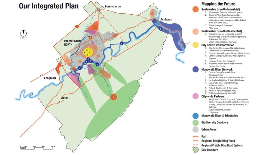
As part of its long-term planning, PNCC has identified a series of major projects that will help achieve the Council’s vision and goals for Palmerston North.19
These catalyst projects are captured in PNCC’s Spatial Plan, which provides important context for this report. The projects are grouped into three main focus
areas or “city shaping moves” as outlined below.
Enabling Sustainable Growth involves the provision of land and infrastructure required to enable sustainable industrial and residential growth. This includes:
• wastewater treatment plant upgrade
• regional freight ring road, rail, airport (multi-modal) infrastructure to enable industrial growth in Longburn and around the airport (North east industrial
zone)
• infrastructure for residential growth at Whakarongo (including Council’s own development), City West, Aokautere, Ashhurst and urban intensification
• water storage and drainage
Transforming the city centre involves the creation of a more vibrant city centre that will make the city more liveable for residents and attract more business
investment and visitors. This includes:
• city centre streetscape redesign plan and projects
• Te Manawa 2025 redevelopment
• Library of the Future
• Central Energy Trust Arena masterplan and projects
• heritage protection package
• initiatives with City Business Partners
Developing recreation activities along the Manawatū River is aimed at delivering lifestyle benefits for residents and increasing the city’s attractiveness as a
place to live and visit. This includes:
• Central Energy Trust Wildbase Recovery Centre
• Victoria Esplanade masterplan and projects
• He Ara Kotahi bridge and shared pathway
• Manawatū River shared pathway (Ashhurst to city)
19
https://www.pncc.govt.nz/council-city/what-were-doing/catalyst-projects/.
freshinfo.co.nz 22• Manawatū Gorge (Te Apiti) biodiversity and recreation • Ahimate (Waitoetoe) Park and To Motu-o-Poutoa (Anzac Park) As well as the above projects, the Spatial Plan also identifies major local organisations whose activities and growth plans are key to the long-term ambitions of the city. These “City-wide Partners” include Rangitāne, Massey University, Food HQ, New Zealand Defence, MidCentral DHB and Palmerston North Airport. PNCC’s integrated Spatial Plan is illustrated in Figure 17 below. Figure 17 PNCC Integrated Spatial Plan20 20 PNCC 10-year Plan 2018-2028, p. 27. freshinfo.co.nz 23
Relevant to the “Sustainable Growth (Industrial)” focus area, section 3.2 below outlines PNCC’s vision for the development of a nationally significant
distribution precinct in Palmerston North.
3.2 Central NZ Distribution Precinct
Palmerston North’s freight and logistics sector is a significant and growing segment of the City’s economy. The sector employed 5,500 people in 2019 (10% of
all jobs in the City) and is home to several major distribution centres including Toyota, Ezibuy, Foodstuffs and Countdown. The City is well-placed to provide
transport and logistics services given its central location in the middle of the lower North Island, strategically located between three key ports (Taranaki,
Wellington and Hawke’s Bay) and close to major highway and rail connections.
The City aspires to significantly strengthen its freight and logistics capabilities and become a major participant in the national freight network. To help achieve
this goal, PNCC plans to develop a multi-modal (rail, road and air) freight distribution precinct in the north east of the city (the Central New Zealand (CNZ)
Distribution Precinct).
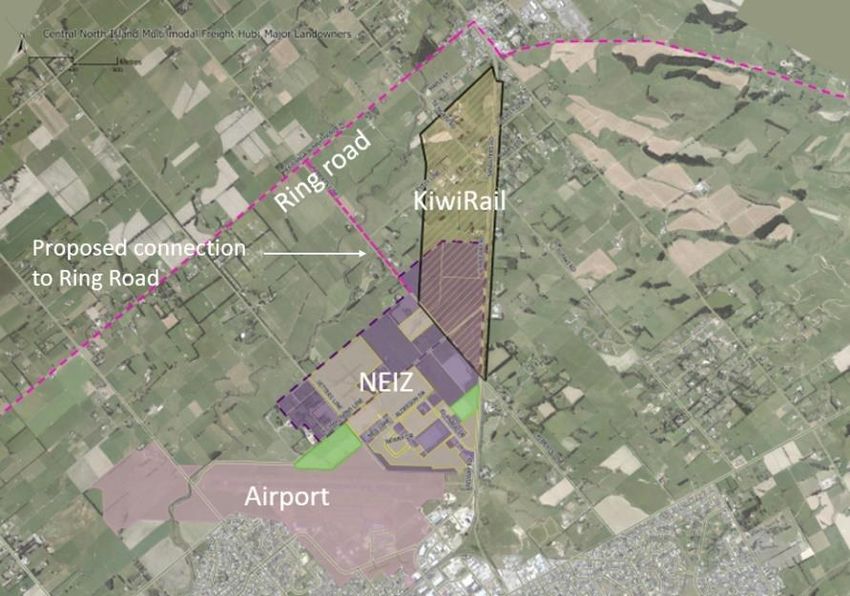
Figure 18 Map of CNZ Distribution Precinct (approximate boundaries)
The CNZ Distribution Precinct will encompass the North east Industrial Zone
(NEIZ), Palmerston North airport and the planned KiwiRail freight hub, with
connections into the planned Regional Freight Ring Road. This will be the only
location in New Zealand with rail, road and air connectivity in adjacent
developments. The precinct is intended to service regional and national freight
movements and act as an engine for growth in the local economy.
Efficient connections between freight precinct participants and their suppliers and
markets will be critical to the precinct’s success. Sections 4 to 6 below outline the
impacts that the three sub-projects within the precinct (the NEIZ, KiwiRail Freight
hub and airport development) are expected to have on the region and examine
the importance of the Ring Road to the value of each project.
freshinfo.co.nz 244 North East Industrial Zone Growth
PNCC and local landowners are in the process of converting an approximately 230 ha area of land in the north east of the city from rural to industrial uses,
with the vision of it becoming a major distribution and warehousing centre for central New Zealand.
4.1 What does the NEIZ growth project involve?
Approximately 230 ha of rural land in the north east of the city near Bunnythorpe has been rezoned to house large-format transport, warehousing and
logistics operations (the North East Industrial Zone (NEIZ)). This land is well-suited to such activities because it is flat, not in a flood plain, free from
surrounding residential and commercial activities that could constrain its operations and growth, and adjacent to the main trunk railway line (and the planned
KiwiRail Freight Hub) and the airport. The NEIZ has been zoned in stages, with the first 95 ha rezoned in 2004, an additional 12 ha rezoned in 2010 and a
further 126 ha (the NEIZ Extension) rezoned in 2017.
Approximately 36 ha of the NEIZ has been developed to date21, with a further 55ha secured with the intention to develop. Current major occupants include
Foodstuffs and Ezibuy.
4.2 What are the expected impacts of the NEIZ growth project?
The NEIZ is an important economic development opportunity for the region. By providing a large amount of land suitable for large format warehousing and
distribution activities adjacent to key transport connections, the NEIZ is expected to stimulate investment by freight & distribution businesses in the region,
leading to growth in the sector and associated increases in economic activity and employment. The economic development opportunity is expected to be
significantly enhanced once the KiwiRail Freight Hub and Ring Road come online, providing more efficient connections between the NEIZ and rail and road
networks.
Table 3 below summarises the expected economic, social and environmental impacts of the NEIZ project.
Table 3 Expected outcomes and impacts of NEIZ
NEIZ outcomes Economic Impacts Social & environmental impacts
More land options available for large footprint freight & Reduced pricing pressure on industrial land as a result of More job opportunities in the freight & distribution
distribution businesses more zoned land being available sector
Increased investment by new and existing freight & Population growth if people migrate to Palmerston
distribution businesses, with spillover effects for North to take up job opportunities
supporting businesses
21 Ref. KiwiRail NOR Integrated Transport Assessment p. 43.
freshinfo.co.nz 25Potential for pressure on house prices if demand for
housing grows as a result of increased net migration
Existing large footprint freight & distribution businesses Central city land released for other higher value uses Enhanced liveability and amenity value for people living
relocate from central city to NEIZ (e.g. commercial, residential, mixed use) and working in the central city, as a result of reduced
noise, vibrations, odours, etc.
Higher central city land values as noise, vibrations,
odours, etc. generated by freight & distribution Longer commutes for NEIZ staff whose place of work
businesses migrate to NEIZ becomes further from home, with associated increases in
CO2 emissions (shorter commutes for others)
Longer journeys for some freight suppliers/customers
who are further from distribution centres, with Increased CO2 emissions resulting from increased travel
associated increases in travel time and VOCs times for commuters and freight carriers who are further
from distribution centres
Enhanced reputation of Palmerston North as significant Increased investment by new and existing freight & More job opportunities in the freight & distribution
freight & distribution hub distribution businesses, with spillover effects for sector
supporting businesses
Population growth if people migrate to Palmerston
North to take up job opportunities
Potential for pressure on house prices if demand for
housing grows as a result of increased net migration
Potential for increased heavy traffic volumes on urban Increased travel times and VOCs for users of urban Reduced liveability and amenity for people living and
arterials resulting from increased activity at NEIZ and arterials, if higher traffic volumes cause (or worsen) working on or near arterials as noise, air pollution,
shifts in traffic flows congestion vibrations, etc. increase along with traffic volumes
Less convenient connections to employment, schools,
and other destinations residents wish to access
Reduced actual and perceived safety for road users
Reduced opportunities for walking and cycling resulting
in poorer health and wellbeing
4.3 How are the impacts of the NEIZ growth project likely to change as a result of the Ring Road?
According to current plans, the Ring Road will be located within 1-2 kms of the NEIZ. The Ring Road will provide efficient, fit-for purpose roading connections
for vehicles traveling to and from the NEIZ. As a result, we would expect to see significant volumes of freight traffic migrate away from existing arterials and
onto the Ring Road. This will increase safety and efficiency for freight vehicles and help to relieve congestion on existing urban arterials, allowing traffic to
move more freely within the central city and lifting amenity values for residents and visitors.
freshinfo.co.nz 26You can also read