In-flight breakup involving Cessna 210, VH-HWY - ATSB Transport Safety Report Aviation Occurrence Investigation
←
→
Page content transcription
If your browser does not render page correctly, please read the page content below
In-flight breakup involving
      Insert document      title
      Cessna 210, VH-HWY

      22 km east
      Location    of Darwin Airport, Northern Territory | 23 October 2017
               | Date

                      ATSB Transport Safety Report
Investigation
                      [Insert Mode]
                      Aviation Occurrence
                                      Occurrence
                                            Investigation
                                                 Investigation
                      XX-YYYY-####
                      AO-2017-102
                      Final – 9 April 2019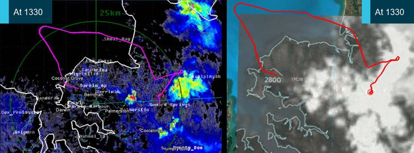
Cover photo:       Air Frontier

Released in accordance with section 25 of the Transport Safety Investigation Act 2003

Publishing information

Published by:        Australian Transport Safety Bureau
Postal address:      PO Box 967, Civic Square ACT 2608
Office:              62 Northbourne Avenue Canberra, Australian Capital Territory 2601
Telephone:           1800 020 616, from overseas +61 2 6257 4150 (24 hours)
                     Accident and incident notification: 1800 011 034 (24 hours)
Email:               atsbinfo@atsb.gov.au
Internet:            www.atsb.gov.au

© Commonwealth of Australia 2019

Ownership of intellectual property rights in this publication
Unless otherwise noted, copyright (and any other intellectual property rights, if any) in this publication is owned by
the Commonwealth of Australia.

Creative Commons licence
With the exception of the Coat of Arms, ATSB logo, and photos and graphics in which a third party holds copyright,
this publication is licensed under a Creative Commons Attribution 3.0 Australia licence.

Creative Commons Attribution 3.0 Australia Licence is a standard form license agreement that allows you to
copy, distribute, transmit and adapt this publication provided that you attribute the work.

The ATSB’s preference is that you attribute this publication (and any material sourced from it) using the
following wording: Source: Australian Transport Safety Bureau

Copyright in material obtained from other agencies, private individuals or organisations, belongs to those
agencies, individuals or organisations. Where you want to use their material you will need to contact them
directly.

Addendum
    Page             Change                                                                           Date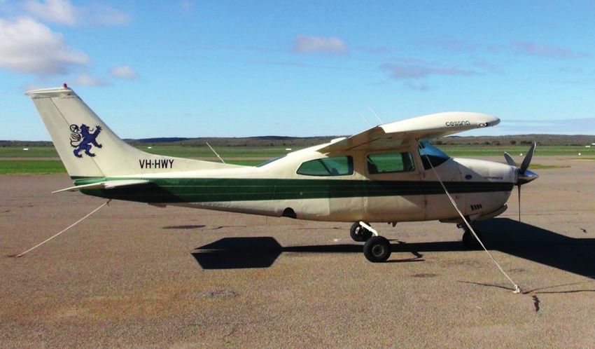
Safety summary
What happened
                                                       VH-HWY in Darwin
On 23 October 2017, a charter flight operated by
Air Frontier using a Cessna C210L aircraft,
registered VH-HWY (HWY), was tasked to transport
a coffin with a deceased person from Darwin Airport
to Elcho Island, Northern Territory. There were two
pilots on board – the supervising pilot in command
in the right seat and the pilot in command under
supervision on the left. After departing Darwin at
1307 CST, the left seat pilot requested air traffic
control (ATC) for a 5 NM diversion left or right of
track to avoid adverse weather. The aircraft was       Source: Air Frontier
cleared to divert right of track, and to climb to
9,500 ft. After 4 minutes, ATC asked whether further
track diversions were required; first 10 NM, then 20 NM, which were accepted.
At 1332, the aircraft entered an uncontrolled descent before it collided with terrain. The pilots were
fatally injured and the aircraft destroyed.

What the ATSB found
Shortly after VH-HWY diverted to avoid adverse weather, the aircraft entered an area of strong
convective activity and rapidly developing precipitating cells, which resulted in it experiencing
severe turbulence and possibly reduced visibility for the pilots. While flying in these conditions, a
combination of airspeed, turbulence and control inputs probably led to excessive loading on the
aircraft’s wings, which separated from the fuselage in-flight before it collided with terrain.
The ATSB found that the pilots had no experience flying in the ‘build-up’ to the wet season in the
Darwin area. Although pairing a supervisory pilot with a pilot new to the company was likely to
reduce risk in other instances, in this case it did not adequately address the weather-related risks
because neither pilot had experience flying in the region during the wet season.

Safety message
Recognising and avoiding tropical weather conditions that present significant hazards to flight can
be particularly challenging for pilots without operational experience in the tropics. Knowing how to
reduce the risk, including the appropriate distance to keep away from thunderstorms and cumulus
clouds predominantly comes through exposure to those conditions. In many cases, deviations of
10 NM to avoid phenomena like towering cumulus clouds may not be sufficient.
Pilots are encouraged to use all available resources to avoid adverse weather, including forecasts
and requesting ATC assistance. Awareness of the weather avoidance actions of other pilots in the
area can also be useful. There is considerable value in ongoing education and guidance for pilots
in recognising and responding to deteriorating weather conditions during flight. This can include
additional (cue-based) training, guidance specific to the risks in the region, education initiatives
from industry bodies, and learning from the knowledge and experience of peers.
Smaller operators employing pilots with limited exposure to local conditions, such as in the tropics,
can better manage related risks by pairing new pilots with ones experienced in those conditions.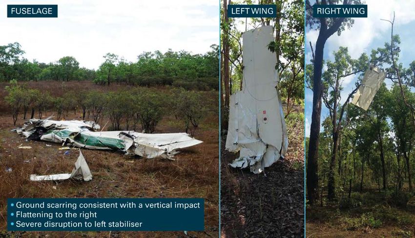
Contents
  The occurrence ........................................................................................................................1
  Context ......................................................................................................................................4
       Pilot information                                                                                                                        4
       Medical and pathological information                                                                                                     4
       Aircraft information                                                                                                                     5
       Operational information                                                                                                                  7
       Meteorological information                                                                                                               7
       Air traffic control                                                                                                                    10
       Accident site information and wreckage examination                                                                                     11
       Survivability                                                                                                                          14
       Recorded information                                                                                                                   14
       Company information                                                                                                                    15
       Human performance considerations                                                                                                       18
       Related occurrences                                                                                                                    21
  Safety analysis ...................................................................................................................... 23
        Encountering adverse weather and turbulence                                                                                      23
        Wing separation from fuselage in-flight                                                                                          23
        Crew pairing in the wet season                                                                                                   24
        Disclosure of medical history                                                                                                    24
  Findings ................................................................................................................................. 26
        Contributing factors                                                                                                                 26
        Other factors that increased risk                                                                                                    26
  General details ...................................................................................................................... 27
       Occurrence details                                                                                                                27
       Right seat pilot details – Supervisory pilot                                                                                      27
       Left seat pilot details – Pilot in command under supervision                                                                      27
       Aircraft details                                                                                                                  27
  Sources and submissions .................................................................................................. 28
       Sources of information                                                                                                28
       References                                                                                                            28
       Submissions                                                                                                           29
  Australian Transport Safety Bureau .................................................................................. 30
        Purpose of safety investigations                                                                                30
        Developing safety action                                                                                        30
        Terminology used in this report                                                                                 31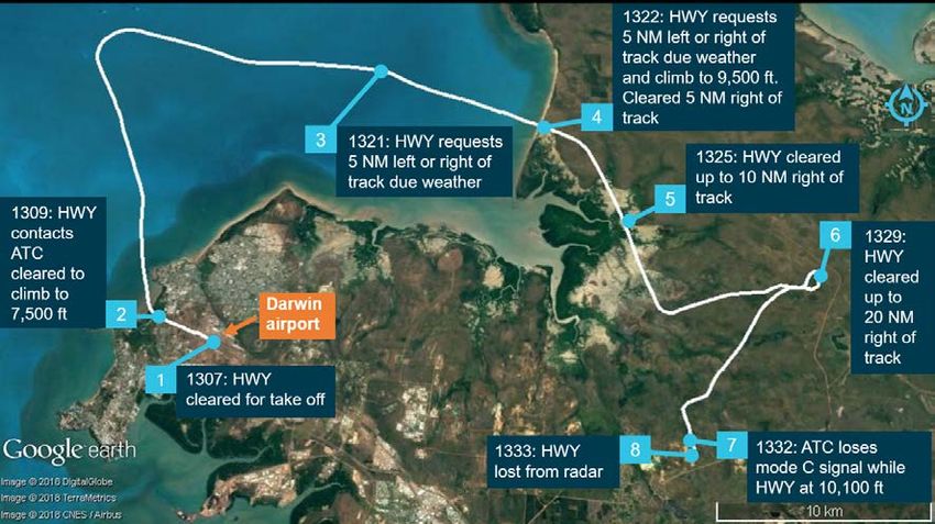
ATSB – AO-2017-102
The occurrence
On 23 October 2017, a charter flight operated by Air Frontier using a Cessna C210L aircraft,
registered VH-HWY (HWY), was tasked to transport a coffin with a deceased person from Darwin
Airport to Elcho Island, Northern Territory. There were two pilots on board: the pilot in command
under supervision (ICUS) 1 in the left seat (the ‘left seat pilot’), and the supervisory pilot in the right
seat (the ‘right seat pilot’), the nominated pilot in command (PIC). The flight was operating under
visual flight rules (VFR), 2 and the pilots submitted a flight plan that documented a planned cruising
altitude of 7,500 ft to Elcho Island. They also checked the weather and NOTAMs, 3 and completed
their flight planning at about 1045 Central Standard Time. 4
At about 1100, a funeral services staff member arrived at Air Frontier’s hangars at the airport with
the coffin. The two pilots, the company’s training manager and funeral services staff loaded the
coffin into the aircraft’s cabin and secured it. At about 1115, HWY taxied out to the engine run-up
bay. During the engine run-up procedure, the pilots identified a drop in the magnetos. They
returned to the hangars where the chief engineer identified a fouled spark plug. He resolved the
issue by running the engine at a high RPM for a short period.
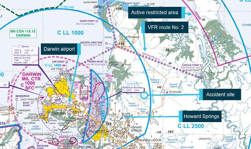
Shortly after, HWY again taxied out for departure. The pilots requested the VFR route 2 to Elcho
Island (Figure 1). At 1304, the left seat pilot called ‘ready’ to air traffic control (ATC) 5, and was
cleared for take-off on runway 29 at 1307.
Figure 1: Darwin Airport and pertinent features on the visual terminal chart
Source: Airservices, annotated by ATSB
1 In command under supervision: according to CASA, ‘a person flies an aircraft as pilot acting in command under
supervision if, during flight time in the aircraft, the person performs the duties and functions of the pilot in command
while under the supervision of the pilot in command approved for the purpose by the operator of the aircraft’.
2 Visual flight rules (VFR): a set of regulations that permit a pilot to operate an aircraft only in weather conditions
generally clear enough to allow the pilot to see where the aircraft is going.
3 A Notice to Airmen (NOTAM): alerts pilots of potential hazards along a flight route or a location that could affect the
safety of flight.
4 Central Standard Time (CST): Coordinated Universal Time (UTC) + 9.5 hours.
5 The Australian Defence Force provides the air traffic control services associated with Darwin Airport.
›1‹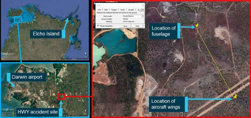
ATSB – AO-2017-102

As the aircraft climbed through 700 ft, the left seat pilot contacted ATC and was cleared to climb to
7,500 ft and turn onto a heading of 320° (items 1 and 2 in Figure 2). About 5 minutes later, the
controller cleared the aircraft to turn right onto a heading of 100° (item 3 in Figure 2).
At 1322, as the aircraft tracked east and climbed through 6,100 ft, the pilot requested diverting
5 NM left or right of track due to weather (item 4 in Figure 2), and to climb to 9,500 ft. Air traffic
control advised that diverting left of track was unavailable due to the active restricted airspace
nearby (Figure 1), and cleared a diversion up to 5 NM right of track, and a climb to 9,500 ft. At
1325, the controller asked the pilot to advise if further clearance was required. The pilot
responded, ‘affirm, request up to 10 miles right of track’.
Soon after, the aircraft turned north-east and continued to climb for 4 minutes to about 10,000 ft.
At 1329, the controller recalled observing that the aircraft abruptly turned to the south-west. The
controller asked the pilot if they required alternate tracking (item 8 on Figure 2). The pilot replied
‘affirm’ and the controller cleared the aircraft to deviate up to 20 NM right of track. The aircraft
continued to track south-west.
Figure 2: Aircraft track with pertinent broadcasts between HWY and ATC

Source: RAAF radar data overlaid on Google Earth, annotated by ATSB

Between 1329 and 1331, ATC radar recorded the aircraft descending and climbing between 9,600
and 10,100 ft (see Recorded data section). At 1332:20, its altitude information (radar mode ‘C’)
showed the aircraft descending before it disappeared from the radar display (item 8 in Figure 2).
The controllers quickly assessed its disappearance as abnormal.
About 10 seconds later, ATC audio recorded three short transmissions, possibly from separate
‘push-to-talk’ activations from the aircraft’s radio. At 1332:45, the controllers recalled that the
aircraft’s altitude (mode C) briefly reappeared (local radar data indicates the aircraft was at
approximately 5,000 ft). The controllers reported that the aircraft disappeared from the radar
screen 15 seconds later. Over the next 10 minutes, they unsuccessfully attempted to call the pilot.
They then declared a ‘distress phase’ 6 and requested an aircraft in the area to assist with looking
for the missing aircraft.
Witnesses near Howard Springs (Figure 1) reported sighting the aircraft (HWY) descending
rapidly in a relatively flat attitude, possibly rotating, with a portion of each wing missing. One of the

6   Distress phase: A situation wherein there is reasonable certainty that an aircraft and its occupants are threatened by
    grave and imminent danger or require immediate assistance

                                                           ›2‹
ATSB – AO-2017-102

witnesses that saw the aircraft impact terrain called emergency services, and then attended the
scene.
Emergency services started arriving within 10 minutes of the impact. The main fuselage was
located less than 1 NM from the aircraft’s last recorded radar position. Both of its wings were
found about 700 m south-east of the fuselage.
The pilots were fatally injured in the accident and the aircraft was destroyed.

                                               ›3‹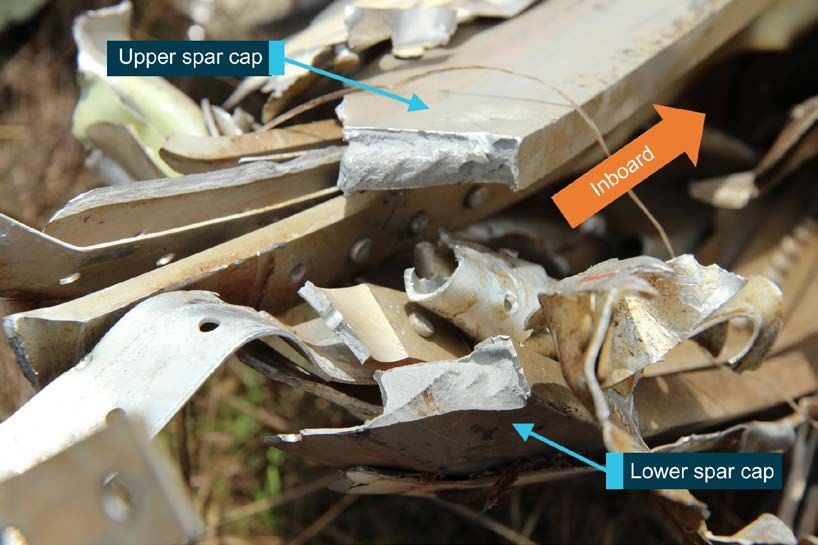
ATSB – AO-2017-102

Context
Pilot information
Right seat pilot
The right seat pilot was the pilot in command of the aircraft and supervising the left seat pilot. He
held a commercial pilot licence (aeroplane) issued in March 2016 and a class 1 medical certificate
valid until December 2017. At the time of the accident, he had a total of 705.9 hours of
aeronautical experience, including about 400 hours in C210 aircraft. He was appropriately
endorsed to operate VH-HWY as pilot in command, and held an instrument rating for multi-engine
aircraft. In the 7 months prior to the accident, he had not logged any instrument flight time.
After starting with Air Frontier in April 2017, the pilot had completed 415.8 hours of flying. He was
based at Maningrida, NT from June 2017 onwards before being transferred to Elcho Island.
On the morning of 23 October before the accident flight, the pilot completed a proficiency check
with the training manager to act as a supervisory pilot in single engine aircraft. The 0.9-hour check
flight in the circuit at Darwin Airport included proficiency in aircraft handling, handover/takeover
procedures and a discussion of aspects such as the potential for parallax error when viewing
aircraft instruments, handling high workloads, supervisory pilot responsibilities and wet season
operations. The pilot’s training record indicated covering VFR procedures, including cloud
separation, maintaining visual meteorological conditions (VMC), cockpit procedures, and
airmanship.

Left seat pilot
The left seat pilot was the pilot in command under supervision (ICUS). He held a commercial pilot
licence (aeroplane) issued in September 2012 and a class 1 medical certificate valid until May
2018 (with a restriction for distance vision correction). At the time of the accident, the pilot had a
total of 381.4 hours of aeronautical experience, including 12.7 hours in the C210 aircraft. He was
appropriately endorsed to operate VH-HWY as pilot in command, and held an instrument rating for
multi-engine aircraft obtained in 2012. The left seat pilot underwent an instrument proficiency
check in May 2017. He had a total of 34.4 instrument hours in flight and 35 hours in a simulator.
The pilot’s first flight in a C210 aircraft was on 15 September 2017. He then logged a total of
5.4 hours dual time.
After moving to Darwin in early October 2017, the pilot conducted a number of observation flights.
He started flying as pilot ICUS on October 14 and completed three flights with a total of 7.3 hours.
He had not signed Air Frontier’s operations manual or completed what they called a Professional
Pilot Development Course agreement in accordance with its procedures for pilots ICUS.

Fatigue
The ATSB obtained available evidence to assess the likelihood of the pilots experiencing fatigue.
This included factors that affect the ability to maintain adequate alertness, rostering, other aspects
that affect sleep opportunity and sleep obtained. There was insufficient evidence to ascertain
whether either pilot was likely experiencing a level of fatigue known to affect performance.

Medical and pathological information
A prescription medication belonging to the left seat pilot was found in the wreckage. The pilot’s
toxicology report confirmed the presence of this medication. The medication was not recorded in
the pilot’s medical file with Civil Aviation Safety Authority (CASA).

                                               ›4‹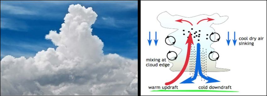
ATSB – AO-2017-102

The ATSB followed up available information sources, including the pilot’s DAME, but could not
definitively determine why the medication was not recorded in the pilot’s medical files. Civil
Aviation Safety Regulations (1998) Part 67 describe the requirements for aviation medicals. One
of the criteria for a class 1 medical certificate prohibits the use of ‘any over-the-counter or
prescribed medication or drug… that causes the person to experience any side effects likely to
affect the person to an extent that is safety-relevant’.
Further, medical certificate applicants are required to answer ‘every question asked by the
examiner that the examiner considers necessary to help…CASA decide whether the applicant
meets the relevant medical standard’. They are obliged to notify CASA of changes in medical
conditions that impair their ability to ‘do an act authorised by the license’.
The following extracts from CASA-developed brochures are particularly relevant to pilot medicals.
      DAMEs and pilots together should foster a culture where it is likely that pilots will feel comfortable
      disclosing medical problems, even if they may impact on their ability to maintain an aviation medical.
      Your DAME…will expect you to answer both written and verbal questions, honestly and fully...

Under the clinical practice guidelines for designated aviation medical examiners (DAMEs), certain
risk assessment protocols allowed them to take into account the pilot’s need for medication use.
That assessment involved reviewing past and current symptoms of certain conditions, an
applicant’s compliance with medications and treatments, and any relevant side-effects.
A CASA brochure states ‘only 0.29% of all initial and renewal medical certificates were refused by
CASA during 2016-2017’. In the case of prescription medication, once it is declared the safety-
relevance of the condition as well as medication can be considered.

Aircraft information
General overview
The Cessna Aircraft Company 210L is a six-seat, high cantilever wing, single-engine aircraft
equipped with retractable tricycle landing gear and was designed for general utility purposes.
The accident aircraft, HWY, was manufactured in the United States (US) in 1974. It was first
registered in Australia in 1988, with a total time in service of 1,456.1 hours. The aircraft was to
operate in the charter category and maintained under a CASA-authorised system of maintenance.
The aircraft was powered by a Teledyne Continental IO-550P engine. The wing construction
consisted of a forward spar, main spar, conventional formed sheet-metal ribs and aluminium skin.
The inboard section of each wing, forward of the main spar, was sealed to form an integral fuel
tank. The fuel system is essentially gravity-flow from the tank outlets to the selector valve, with
pump augmentation from the valve to the engine.
The US Federal Aviation Administration’s (FAA) Airworthiness Directive (AD) 2012-10-04 Wing
main spar lower cap inspection applied to HWY. This AD required an inspection of the left and
right wing lower main spar caps for cracks. An inspection of HWY conducted in accordance with
the AD in June 2012 identified no defects. The aircraft did not fly between November 2014 and
March 2016 (with a total time in service of 5,847 hours) and during this time, the wing main spar
carry-through was replaced with a serviceable item due to corrosion. Since March 2017, HWY
was operated and maintained by Air Frontier under an approved system of maintenance.
A review of the aircraft maintenance records did not identify any evidence of accident-related
damage to the aircraft, including its wings. In addition, there was no evidence of overdue
scheduled maintenance, including ADs.
On 26 September 2017, following a periodic inspection of the aircraft, a new maintenance release
was issued (current at the time of the accident). A scheduled, 50-hourly inspection was conducted
on the morning of the accident (6,499.2 airframe hours). There were no reported concerns with

                                                  ›5‹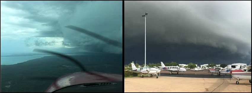
ATSB – AO-2017-102

aircraft serviceability when it departed Darwin Airport before the accident flight nor did the pilots
report any aircraft-related issues to ATC during the flight.

Aircraft load factors
The four forces acting on an aircraft in flight are lift, weight, thrust and drag. The ratio of lift to
weight is the load factor (n). In straight and level flight, lift and weight are the same, so n=1 and
the pilot experiences a force of 1 g. Lift can be calculated using the following equation.
           L = CL ½ ρ V2 S
           {that is, lift (L) is equal to the coefficient of lift (CL) x half the density (ρ) x velocity squared
           x the wing surface area (S)}.
For a given wing design, lift is proportional to the angle of the wing relative to airflow (angle of
attack) and proportional to the square of wing velocity (airspeed). The pilot increases or decreases
lift either by changing the angle of attack or the airspeed. As the aircraft’s wings produce lift, its
structural limit is the strength of the wings. Structural limits are based on the load factor, which is
affected by any one or combination of the following:
• full or abrupt control movement above VA
• banking or turning – for example, a 60-degree turn is 2 g 7
• windshear, turbulence or gusts – severe turbulence is defined as variations in vertical
  acceleration greater than 1 g
• disorientation, unusual attitude and/or recovery can result in exceeding load factor limits
• spiral dive and/or recovery.
Before an aircraft is certified, its structures must meet structural design standards. Section 2 of the
Pilot Operating Handbook for HWY specified load limits with the flaps up as +3.8 g and -1.52 g,
and flaps down as +2.0 g. The handbook stated that the ‘design load factors are 150 per cent of
the above, and in all cases the structure meets or exceeds design loads’. Thus, the ultimate load
for the aircraft was 5.7 g, and US Federal Aviation Regulation 23 (which governed its design)
stipulated that the structure must be able to support ultimate loads without failure for at least 3
seconds. 8
The operating flight strength presented in a V-n diagram (Figure 3) shows the flight envelope. The
manoeuvring speed (VA) for HWY was 118 kt (at maximum take-off weight) 9, maximum structural
cruise speed (VNO) was 165 kt and never exceed speed (VNE) was 196 kt. An aircraft must be
operated within the envelope 10 to prevent structural damage, or stall. 11
An envelope exists for gust loads to outline the aircraft’s limitations to withstand a 30 ft per second
gust load. Moderate turbulence, for example, is defined as 20-35 ft per second gusts and severe
is 36-49 ft per second.
Exceeding the flight load limit below VA results in a stall, whereas exceeding the flight load limit at
a speed above VA has the potential to damage the aircraft’s structure.

7    G load: the nominal value for acceleration. In flight, g load represent the combined effects of flight manoeuvring loads
     and turbulence and can have a positive or negative value.
8    Ultimate load: the limit load multiplied by prescribed factors of safety. The aircraft structure must be able to support the
     ultimate load without failure for at least three seconds.
9    Note that the manoeuvring speed decreases with aircraft weight.
10   Flight envelope: the range of combinations of speed, altitude, angle of attack etc., within which a flying object is
     aerodynamically stable.
11   Aerodynamic stall: occurs when airflow separates from the wing’s upper surface and becomes turbulent. A stall occurs
     at high angles of attack, typically 16˚ to 18˚, and results in reduced lift.

                                                             ›6‹
ATSB – AO-2017-102
Figure 3: Representation of operating flight strength (V-n) diagram
Source: ATSB
Operational information
Planned flight path
The flight plan documented a planned altitude of 7,500 ft and a magnetic track of 082° direct to
Elcho Island. The recorded fuel upload was 336 litres, with a planned fuel burn of 55 litres over the
estimated flight time of 1 hour 52 minutes. The planned departure time was 1130.
On departure, the pilot of HWY amended the plan to track via the published VFR route 2.
Airservices Australia En Route Supplement Australia – Flight plan requirements, stated ‘VFR
aircraft departing and arriving [Darwin] DN…are required to plan via a published DN VFR Route,’
VFR route 2 was the published route in the direction of Elcho Island.
Weight and balance
The aircraft was loaded within its weight and centre of gravity limitations for the flight. The
recorded weight of the coffin was 95 kg. The estimated aircraft weight at take-off was 1,624 kg,
and at its last position was 1,603 kg. There was no evidence to indicate any weight and balance
issues, including a possible load shift in flight.
Meteorological information
Weather in the ‘build-up’ to the wet season
Weather conditions in Darwin and surrounding areas are typical of the Australian tropics, and in
the wet season (October to April), the prevailing conditions are more hazardous to flying. Among
the Bureau of Meteorology’s (BoM) weather advice pamphlets for pilots, Flying the Tropics (2012)
›7‹ATSB – AO-2017-102
is particularly relevant. It describes the wet season as ‘a time of unstable atmospheric conditions
due to high humidity and temperatures’. The build-up to the monsoonal part of the wet season
(October and November) is typified by a ‘gradual increase of the convective cloud and humidity’.
Thunderstorms and towering cumulus cells
According to BoM, weather conditions in Darwin during the build-up can include thunderstorms
with clouds up to 45,000 ft that usually develop in the afternoons, and cells that develop rapidly.
As a thunderstorm is growing, updrafts in the range of 15 to 30kts are common with potentially
higher speeds. The BoM Flying the Tropics guide (2012) includes the following about
thunderstorms in the area.
The peak frequency of thunderstorms is in the vicinity of Darwin with over eighty thunder-days per
year…Thunderstorms in the transition periods tend to be more isolated than during the wet season.
These frequently have high bases, flying below which may result in strong downdrafts being
encountered…These updrafts can exist alongside downdrafts of similar strength…resulting in
potential for severe turbulence and loss of aircraft control if flying into such conditions.
With regard to speed of development, BoM indicated that a cell could develop from ‘not much’ to a
towering cumulus with a cloud top of 15,000 ft within 15-20 minutes. In the Howard Springs area
(near the accident site), cells develop at least once a fortnight in the wet season.
Towering cumulus clouds are more prevalent in the wet season (Figure 4, left). They differ from
cumulonimbus clouds (CBs) in that they are not accompanied by lightning and thunder. However,
they have powerful updrafts, downdrafts and lateral air movements (Figure 4, right).
Figure 4: A towering cumulus (left) and the typical cycle of up- and down-drafts (right)
Source: namesofclouds.com and kiwi.atmos.colostate.edu
Risks of turbulence
The risks to flying posed during build-up conditions, and thunderstorms lie in the turbulence
produced. The BoM’s Hazardous Weather Phenomena: Turbulence guide (2014) describes
convective turbulence and its potential impact on flight safety. Although the guide references
cumulonimbus clouds, the following information about turbulence is equally relevant to towering
cumulus clouds.
Convective turbulence in association with cloud is initiated by surface heating and/or low-level
convergence…The convection is enhanced by the release of latent heat during the process of
condensation and subsequent warming and destabilisation of the cloud environs. All cumulonimbus
clouds should be considered to be turbulent. Hence within an aviation weather forecast the mention of
cumulonimbus flags severe turbulence…The most likely turbulent areas in cumulonimbus clouds are:
- the updraft/downdraft boundaries within the cloud
- the leading edge of the gust front
- above the cloud tops
- in any funnel clouds extending from the cloud base...
›8‹ATSB – AO-2017-102
- in the upper parts of the updraft within the cloud
Updrafts are generally stronger than downdrafts, and tend to be strongest in the middle and upper
parts of the cumulonimbus.
In conditions such as towering cumulus clouds or thunderstorms, the speed of vertical updrafts
has the potential to cause severe turbulence, which BoM defined as ‘large abrupt changes in
attitude and/or altitude’ with a ‘momentary loss of control’.
Forecast weather
The area forecast for Darwin valid at the time of the accident flight, included winds of 10 kt from
the south-east at 3,000 ft above mean sea level (AMSL) and from the south at 10,000 ft AMSL.
Isolated cumulonimbus and towering cumulus clouds were forecast, with tops at 45,000 and
25,000 ft AMSL, respectively. The forecast included broken 12 stratus clouds in thunderstorms and
showers of rain and scattered cumulus/stratocumulus. Thunderstorms with rain and visibility
reducing to 1 km, and showers with visibility reducing to 2 km were forecast, along with smoke
and ‘dust devils’ over land.
The aerodrome forecast (TAF) for Darwin issued at 0843 and valid from 0930 to 1530 included
south-easterly wind at 5 kt, visibility greater than 10 km and few cloud at 3,000 ft. The temperature
at 1230 was forecast to be 31°C and the QNH 13 1009 hPa.
Weather encountered by the aircraft
On the day of the accident, the environment was typical of the start of the Northern Territory wet
season known as the ‘build-up’ period.
A thunderstorm to the north of Darwin, combined with the north-west sea breeze, triggered a
convective cell to rapidly develop between 1300 and 1330, about 19 km to the north-east, that is,
between Howard Springs and Koolpinyah (Figure 1). The top of the cell was 6,000 to 7,000 ft at
1300, 9,000 ft at 1320, 13,000 to 14,000 ft at 1330, and about 14,000 ft at 1340. The developing
cumulus clouds likely produced strong updrafts or downdrafts.
Figure 5 shows the aircraft’s track superimposed on weather radar (showing precipitation) and the
satellite images (showing cloud). These images indicate the aircraft tracking in close proximity to a
precipitating cell and a rapidly developing towering cumulus cloud.
At about the same time (from 1300 to 1330), ATC data shows that other aircraft to the east of
Darwin Airport deviated around the weather. An inbound aircraft from the east that deviated south
to avoid a large cell reported it having a cloud top of 14,000 ft. Shortly after, another aircraft
reported a large, black cell in the area.
Witnesses saw a large cumulus cell form over the Howard Springs area before the accident, and
described it as a regular occurrence in the build-up season. Some recalled the cloud went ‘very
black’ at the time of the accident.
The pilots of a number of aircraft arriving into Darwin at about 1300 recalled that the adverse
weather in the region was ‘growing’. One pilot reported that the cell over Howard Springs had an
anvil shape that was flattening out. This pilot also indicated that he may have had reservations
flying at 9,500 ft, and would have requested a deviation of at least 20 NM south of their planned
track. Another pilot inbound to Darwin on an IFR flight undertook a deviation around the storm.
12 Cloud cover: in aviation, cloud cover is reported using words that denote the extent of the cover – ‘few’ indicates that up
to a quarter of the sky is covered, ‘scattered’ indicates that cloud is covering between a quarter and a half of the sky,
‘broken’ indicates that more than half to almost all the sky is covered, and ‘overcast’ indicates that all the sky is
covered.
13 QNH: the altimeter barometric pressure subscale setting used to indicate the height above mean seal level.
›9‹ATSB – AO-2017-102
Figure 5: Aircraft track superimposed on weather radar (left) and satellite image (right)
Source: Bureau of Meteorology, annotated by ATSB
Air traffic control
The Royal Australian Air Force (RAAF) provides air traffic control (ATC) services for Darwin. The
ATSB interviewed a number of controllers on duty at the time of the occurrence. Audio recordings
and other relevant information were also obtained.
Pilot requests for weather deviations
Audio data confirms that one of the pilots requested ‘five miles left and right of track due weather’
and ATC cleared HWY to ‘deviate up to five miles right of track only due Restricted airspace’. The
Restricted airspace was active due to a military exercise but none of the aircraft involved in it were
airborne at the time. Therefore, had the pilot of HWY indicated a need to deviate left of track only
(by using the phraseology ‘require’), ATC indicated that it would have facilitated this request.
However, it could not be determined how the pilots perceived the weather to their left. Further,
weather radar (Figure 5) also indicated significant cloud and precipitation to the left. The approach
controller reported that a deviation right of track allowed HWY to deviate as far south as required,
and at their cleared altitude of 9,500 ft, it would remain above incoming traffic. Additionally, the
controller said that if the pilots wanted to return to Darwin, they would be able to track them via
Lee Point without conflict with other aircraft.
All the RAAF controllers interviewed indicated that if HWY had requested a deviation left of track,
this would have been granted. Some Darwin-based pilots said it was not well-known pilots could
‘require’ a specific deviation. During visits to the ATC facility that were sometimes arranged for
new pilots in the region, the controllers encouraged pilots to be assertive with any requirements,
especially as the pilots always have better visibility of the weather and the track deviations they
need than ATC.
Weather avoidance responsibilities
The Airservices Australia Aeronautical Information Publication (AIP) Australia describes the
respective responsibilities of pilots, meteorologist and air traffic services (ATS) to avoid hazardous
weather as follows.
Pilots, meteorologists and ATS cooperate to ensure accurate information is promulgated to assist
pilots in the avoidance of hazardous weather…and phenomena associated with thunderstorms.
The pilot must advise ATS promptly of any hazardous weather encountered, or observed either
visually or by radar…Hazardous weather includes, in particular, thunderstorms, severe turbulence,
hail, icing, line squalls, and volcanic ash cloud…Pilots are responsible for the safety of their own
aircraft using advices and clearances passed by ATS and information obtained from their own visual
or airborne radar observations.
› 10 ‹ATSB – AO-2017-102
In this case, there were no specific pilot reports provided by those in- or out-bound from Darwin.
Limitations of weather radar
The AIP states that ATS is responsible for the following.
…distributing reports of hazardous meteorological conditions to pilots as a part of the Flight
Information Service. ATS also makes visual and limited radar weather observations for the information
of meteorologists and pilots, and is responsible for relaying pilot weather reports to the BoM. At some
locations, ATS may supplement weather advice with weather radar data.
The RAAF controller had only the BoM weather radar (set to 128 km range) displayed on a
console screen. In addition to any difficulties monitoring these screens, an accurate understanding
of the weather using the radar image is limited as only precipitation is displayed (not cloud) and
also due to time delays.
A Federal Aviation Administration (2005) guide for weather planning and decision making, advises
pilots to keep abreast of changing weather conditions by noting if other GA aircraft in the area are
requesting diversions, and asking ATC for information. The guide also indicates that ATC’s ability
to provide this information has the following limitations.
When you ask ATC for weather information, though, you need to be aware that radar – the controller’s
primary tool – has limitations, and that operational considerations (e.g., use of settings that reduce the
magnitude of precipitation returns) will affect what the controller can see on radar.
Radar “sees” only those entities that reflect energy. These include precipitation, the density of which is
indicated by the strength of the return. Radar does not detect or “see” turbulence, but its existence
may sometimes be implied by the intensity of a precipitation return: the stronger the return, the more
likely the presence of turbulence.
In this case, several other aircraft to the east of Darwin requested track diversions due to weather.
Accident site information and wreckage examination
Wreckage location
The fuselage was located in scrub near Howard Springs, about 22 km east of Darwin Airport and
about 700 m north of Gunn Point Road. The wings were located about 24 m apart from each
other, and about 740 m south-southeast of the fuselage, consistent with an in-flight breakup
(Figure 6). There was no evidence of fire. Various aircraft components were located between the
fuselage and an area about 70 m beyond the wings, over 810 m in total.
On-site examination
On-site examination of the severely impact-damaged fuselage (Figure 7), engine and propeller
identified no pre-existing faults or anomalies that could have contributed to the accident.
Examination of the wreckage indicated that the aircraft impacted terrain from a vertical descent,
right side slightly down, in an almost level attitude.
A number of aircraft components were retained for further examination and testing. The propeller
did not exhibit any evidence of rotation at impact, consistent with fuel exhaustion resulting from the
integral wing-fuel tanks rupturing with the separation of the wings.
The evidence indicated that both pilots were secured in their seats prior to impact.
Notwithstanding the severe disruption to the airframe, examination identified that both pilot seats
were about mid-travel with one locator pin on each seat still engaged in the seat rails.
› 11 ‹ATSB – AO-2017-102
Figure 6: The accident site and location of fuselage and wings
Source: Google Earth, modified by ATSB
Figure 7: The fuselage, left and right wings
Source: Northern Territory Police and ATSB, modified by ATSB
Examination of the aircraft wings
Both wings had separated between 0.5 and 1.5 m outboard from the wing-to-fuselage attachment.
Morphology of all fractures within the wing spars indicated that they failed due to overstress, and
exhibited bending deformation consistent with forces acting upwards and rearwards on the wings.
Examination of the wings showed no evidence of pre-existing defects.
› 12 ‹ATSB – AO-2017-102
Figure 8: Fractured main spar caps from the right wing
Source: ATSB
The lower spar cap shows significant local deformation in an upwards and rearwards direction.
The upper main spar caps had fractured at two points along their length. The left upper spar cap
failed at the location shown in Figure 8. Further inboard, the same spar cap had sheared from the
webbing that secured it to the rest of the wing spar. The deformation observed was consistent with
buckling due to compressive loads, as the wings were bent upwards with forces in excess of the
ultimate positive flight load (Figure 9). In short, the left upper main spar cap deformed enough to
damage the wing skin, consistent with buckling due to compressive loads.
Figure 9: The left upper main spar cap deformation due to compressive loads
Source: ATSB
› 13 ‹ATSB – AO-2017-102
Survivability
Survival in an aircraft accident depends on various aspects, including impact forces imparted on
the occupants being within human tolerance, occupant/seat restraints and liveable space inside
the aircraft. The impact forces alone in this accident meant that it was not survivable.
Recorded information
Track data
The aircraft was not equipped with a flight data recorder or cockpit voice recorder, nor was it
required to be. The aircraft’s GPS unit did not record any data. All recorded data to determine the
aircraft’s track is based on ATC radar data (local and system) and OzRunways data. Analysis of
this data indicated the following.
• There were no apparent aircraft handling problems, up to the recorded point at 1332:28.
• Between 1332:20 and 1332:28, there was a loss in height of 300 ft, and from this point, the
speed of the vertical descent increased rapidly.
• The aircraft impacted the ground approximately 30-40 s after it was at about 10,000 ft.
• After the aircraft was below 8,000 ft, its average vertical speed exceeded 10,000 ft/min, with
periods above 15,000 ft/min and up to 32,000 ft/min.
• There were no on-board recording devices to accurately determine the aircraft’s actual
airspeed. While the forecast winds can be used to estimate airspeed, the actual airspeed
cannot be accurately determined given the likelihood of wind shear and turbulence in the air
mass.
Manoeuvring speed
The aircraft’s manufacturer specified a manoeuvring speed of 118 kt at its maximum take-off
weight. The aircraft’s weight at the time of the breakup was about 1,603 kg, which equates to a
manoeuvring speed of 114 kt (calibrated airspeed), as shown in Figure 10.
At airspeeds above the manoeuvring speed, full or abrupt control inputs or turbulence may
produce wing loading that can damage the aircraft’s structure. At airspeeds above about 145 kt,
this loading can result in failure of the aircraft structure.
The following graph depicts the calibrated airspeed with wind corrections based on the forecast,
noting that actual wind conditions were unavailable, and may be significantly different due to the
proximity to a rapidly developing cell.
› 14 ‹ATSB – AO-2017-102
Figure 10: VH-HWY recorded altitude and groundspeed for the last 10 minutes of flight
Source: RAAF radar data and OzRunways data analysed by ATSB
Company information
Supervisory pilot role
Air Frontier’s new pilots often had limited exposure to the weather conditions of the tropics, and
some had relatively low overall flying experience. In order to prepare them for the work and
assess their suitability, Air Frontier had developed a line operational training process. In a March
2014 Notice to Aircrew (NOTAC), the chief pilot had outlined the pilot ICUS training, and the role
of company appointed supervisory pilots as follows.
ICUS Operations [are when] potential pilot recruits (Trainee Pilots) may gain experience on Company
aircraft and operations as Pilot In-Command-Under Supervision (ICUS) whilst under the supervision
of an experienced Company-approved ICUS Supervisory pilot...
ICUS supervisory pilots are company-approved pilots for supervising Trainee Pilots while they are
undergoing line operational training and suitability assessment…A supervisory pilot is not necessarily
a qualified flight instructor and is expected only to provide training in regards to company procedures
and routes.
Newly recruited pilots completed ground training first and at least one check flight with the chief
pilot before conducting flights with supervisory pilots. Supervisory pilots were responsible for
ensuring the ‘trainee’ followed regulatory requirements and the company’s standard operating
procedures at all phases of flight. If the aircraft was approaching an ‘unsafe state’ during flight,
supervisory pilots were to issue verbal instructions to the trainee but, if required, take over
immediately. The supervisory pilot was considered the pilot in command at all times.
Supervisory pilots were selected by the chief pilot and managing director, after reviewing the
pilots’ logbooks, proficiency check results, and their ‘standing’ in the company. The operator’s
NOTAC outlined minimum requirements for supervisory pilots, and for single engine operations if
the pilot had under 1,000 hours (as was the case with the accident flight), to have worked for the
company for 6 months, have at least 400 hours as PIC and 50 hours on type. The operator had
proactively implemented these minimum (non-mandatory) requirements for supervisory pilot
experience and training to improve their capabilities. They then undertook a training and checking
flight with the chief pilot or delegate, including a training and proficiency assessment in a take-off,
landing and go-around from the right seat, recovery from unusual attitudes in VMC and
(simulated) IMC.
› 15 ‹ATSB – AO-2017-102
Wet season guidance to pilots
Air Frontier provided pilots with policies and guidance relating to conditions experienced in the wet
season, and the operations manual included the following.
…thunderstorms, line squalls and other conditions denoting areas of violent turbulence and/or hail
must be regarded as extremely dangerous and be positively avoided. Avoid flying within 10 km
horizontally of a fully developed cumulonimbus cloud and also directly below the base of the cloud
wherever possible.
Vertical air movement capable of producing extremely severe turbulence is often present near the
edge of the cloud’s base, or in clear air below the overhang of the top. An early decision to divert
around a thunderstorm will need a relatively small heading change and result in minimal distances
added to the flight.
About a week before the occurrence, Air Frontier distributed its Wet Season Guide, developed
internally to assist pilots understand weather conditions to which they would be regularly exposed.
The company aimed to ensure that its many new pilots were prepared to handle various
‘challenging scenarios’.
In its informal style, the Guide included the following topics.
• The importance of planning: encouraged pilots to source forecasts and actual weather
conditions from a range of sources including BoM (including their Rain Radar app) and
OzRunways.
• Fuel management: advised pilots they should ensure that holding and alternate requirements
are met, and take into account additional fuel required to handle conditions indicated by
TEMPOs 14 in the forecast.
• Flying conditions during the wet season: advised pilots to ‘accept either low cloud or low
visibility but not both’, and advising that if a cloud base is high, it is preferable to track lower
through showers, although with cautions about the risks of lower visibility conditions. It stated
that it is better to fly on the upwind side around a storm, and tracking over water if possible.
See Figure 11 for an example of the images included in the guide.
• The role of ATC: stated that ATC is there to help pilots, and to not be afraid of requesting left or
right of track (by 3, 5, or 10 NM) and specific heights to avoid weather. It mentioned that an
area around ‘Jacko’s Junction’ to the east of Darwin was known to have adverse weather.
• Commercial considerations: ‘The decision to fly or not fly can at times be very tough and you
have to use every resource available to you to help you make that decision.’
The training manager also mentioned that pilots received ‘extensive verbal training’ about the
different weather conditions in NT.
A number of Air Frontier’s staff and pilots, and other operators in the region provided comment on
the inherent challenges of the wet season. They knew thunderstorms could form rapidly, were not
always easily detectable on weather radar (dependant on precipitation). They also acknowledged
that pilots had to experience the conditions to get better at managing them and making ‘good
judgements early’ was important.
14 TEMPO: a temporary deterioration in the forecast weather conditions, during which significant variation in prevailing
conditions are expected to last for periods of between 30 and 60 minutes.
› 16 ‹ATSB – AO-2017-102
Figure 11: Large storm cell images illustrated in Air Frontier’s Wet Weather Guide
Source: Operator, with permission
An Air Frontier pilot identified ‘command decision making in high stress environments’ including
operating in Arnhem Land among the skills and knowledge that pilots had to develop after joining
the company. Other company pilots indicated having an iPad with the OzRunways application
installed to see weather radar during flight. They also identified reports from other pilots in the
area or from ATC to manage weather conditions.
Comments about managing weather conditions from pilots working for other operators in the
region included the following.
• One pilot believed a Howard Springs cell was predictable during the wet season as it was an
almost-daily occurrence, and recommended avoiding such cells by 20-40 NM.
• One pilot noted the importance of carrying additional fuel in the wet season, as diverting to
avoid a thunderstorm by 10 NM often was not enough. He had also encountered strong up-
and down-drafts in these conditions.
• Some pilots indicated that it was unlikely an aircraft such as a C210 could out-climb fast-
developing cells that occur in the wet season, and ‘staying low’ was much more preferable.
• A few pilots noted that the practice of ‘Territory VFR’ was prevalent amongst pilots in the Top
End (a reference to VFR pilots briefly climbing through cloud for less turbulent conditions).
After this accident, Air Frontier’s chief pilot spoke with the pilots about the dangers of flying in the
wet season. He encouraged them to inform ATC of their requirements, including the option to fly
into Restricted airspace.
Next of kin notification
As part of the investigation, the ATSB was informed of a delay in being able to notify one of the
pilot’s family. About 15 minutes after the aircraft’s disappearance from ATC radar, controllers
informed Air Frontier’s chief pilot (the emergency point of contact). He called the police, which
confirmed it was attending the accident site. The chief pilot next reported the accident to CASA
and ATSB. He was then able to provide the police with the next of kin details for one pilot, but
found that Air Frontier did not have the same details on file for the other pilot.
Consequently, there was a delay of several hours in informing that pilot’s family while the police
worked to obtain information from alternate sources (previous employment history). On-site, ATSB
investigators later found the pilot’s completed next of kin details form, which had not been
provided to the company.
› 17 ‹ATSB – AO-2017-102
Regulatory oversight
The ATSB reviewed CASA’s surveillance activities and reports for Air Frontier from about 7 years
leading up to this occurrence. These included some relevant findings and observations, mostly
pertaining to operational document control, incomplete documentation on roles such as the
supervisory pilots, and concerns about chief pilots not fulfilling all aspects of their role (mostly due
to workload).
The CASA post-occurrence surveillance report (provided to the operator in November 2017) had
13 findings, and themes including the following.
• Deficiencies in the record keeping for files associated with the new pilot, including flight and
duty time information, licenses and qualifications.
• Absence of evidence around the left seat pilot having acknowledged he had read the
operations manual, or key NOTACs such as the March 2014 on ICUS and supervisory pilots.
• Not having completed some updates to the operations manual to ensure procedures for cargo
loading, ICUS flying, training programs and supervisory pilots were included.
• Perceived deficiencies in the selection and management of supervisory pilots
The report’s summary stated that, based on the findings, there were perceived ‘deficiencies in the
appropriateness of the operator’s organisation and the soundness of its management structure’. In
its response to this report, Air Frontier raised some questions about the accuracy of observations
relating to supervisory pilots but agreed to take all the remedial actions required.
Human performance considerations
The ATSB considered key human factors topics relating to this accident to explore possible
influences on the pilots’ in-flight weather-related decision making and physiological effects
associated with the adverse weather conditions.
Decision making
Naturalistic decision making
It is important to consider pilot decisions it in the context in which the sequence of events
occurred. Orasanu (2000) outlines the concept of naturalistic decision making:
Naturalistic decision-making focuses on understanding how people with domain expertise use their
knowledge to make decisions, typically in safety-critical environments (Cannon-Bowers et al., 1996;
Zsambok & Klein, 1997).
The basis for recognising situations that requires decisions is knowledge (Orasanu, 2000). This
includes ‘determining what information is relevant to the decision, and deciding on an appropriate
course of action…in order to manage risk, threats must be perceived and accurately assessed.’
Orasanu asks, ‘how can flight crews be trained and supported to make the best decisions
possible, especially under challenging high-risk conditions?’
Weather-related decision making
The ATSB (2005) report, General Aviation Pilot Behaviours in the Face of Adverse Weather,
states that ‘weather-related general aviation accidents remain one of the most significant causes
for concern in aviation safety’ which requires pilots to continuously evolve their decision making.
Pilots in general aviation often operate in an ‘uncertain and risky operational domain where they
are confronted with a range of meteorological phenomena about which a series of in-flight
decisions need to be made’ (Hunter, Martinussen and Wiggins, 2003). This information often
comes from a range of sources ‘including meteorological briefings, inflight weather reports, visual
information from the cockpit, and on-site reports.’
› 18 ‹ATSB – AO-2017-102
Wiggens and O’Hare (1995) define weather-related decision making as ‘those skills necessary to
recognize and avoid meteorological phenomena that present a hazard to the flight.’ It is a skill
which is developed ‘gradually through practical experience [but] in developing this type of
experience, relatively inexperienced pilots may be exposed to hazardous situations with which
they are ill-equipped to cope’.
One of the reasons why pilots may decide to continue a flight into adverse weather is that ‘they
make errors when assessing the situation. That is, pilots are seen to engage in VFR flight into
[instrument meteorological conditions] because they do not accurately assess the hazard
(Wiegmann and Goh, 2000). Risk perception can be influenced by personal experience and ability
(Sanders and McCormick, 1993).
The Federal Aviation Administration produced a guide in 2005 called General Aviation Pilot’s
Guide to Pre-Flight Weather Planning, Weather Self-Briefings, and Weather Decision Making.
They suggest that it is the abundance of weather information that may make it difficult for pilots to
focus on key information and ‘correctly evaluate the risk resulting from a given set of
circumstances’.
Weather-related cue-based training and guidance
It may be possible to provide pilots with greater knowledge of adverse weather conditions (and
how the handle them) through training. Wiggins and O’Hare (2003) discussed the benefits of
cue-based training to help pilots ‘recognise and respond to deteriorating weather conditions during
flight.’ Training ‘improved…pilots’ initial response times to deviate around the thunderstorm’ (Ball,
2008).
In recent times, pilots will often use information ascertained from apps on their tablets / iPads,
including graphical weather displays based on radar information. However, Ball (2008) outlined
that ‘previous research suggested that giving pilots the ability to see accurately the weather they
are flying in and around may tempt some pilots to try to fly through small breaks in the convective
activity’. Some pilots would attempt to navigate through or very close to the hazardous weather,
and there are others that used the graphical information to plan and maintain a safe distance
(20 NM or greater) from a storm.
Air Frontier’s chief pilot acknowledged that the wet season can be a very challenging time to fly.
He said pilots should ‘never out-climb the weather’ and aim to be at least 10 NM away from the
weather. The training manager said that during flights with their pilots, he tested them on their
knowledge of weather conditions, and expected they brief on the weather conditions en route.
The CASA-conducted seminars in Darwin address risks of flying in the wet season. The seminars
include briefings from BoM staff, and are designed for junior pilots, or those new to the region.
Effect of experience and familiarity
Blickensderfer and others (2018) assessed that ‘the manner in which expert pilots respond to
hazardous weather scenarios differs from that of less experienced pilot.’ The NTSB (2005)
furthered this by outlining that:
Errors in decision-making, such as plan continuation errors or incorrect assessments of weather-
related risk, may be made by pilots who are unfamiliar with the climate of the local area, who lack total
and/or recent experience identifying marginal weather conditions, or who lack experience accessing
or reading weather reports.
Air Frontier’s training manager commented that many pilots start work with Air Frontier without
having previously encountered the weather conditions in Darwin. Other pilots recalled their own
encounters with the weather soon after they arrived in Darwin, where they were sometimes
unsure of the best action to take when adverse weather was encountered.
› 19 ‹You can also read