INDONESIA'S FOREST MORATORIUM: IMPACTS AND NEXT STEPS
←
→
Page content transcription
If your browser does not render page correctly, please read the page content below
Working Paper

INDONESIA’S FOREST MORATORIUM:
IMPACTS AND NEXT STEPS
KEMEN AUSTIN, ARIANA ALISJAHBANA, TARYONO DARUSMAN, RACHMAT BOEDIONO, BAMBANG EKO
BUDIANTO, CHRISTIAN PURBA, GIORGIO BUDI INDRARTO, ERICA POHNAN, ANDIKA PUTRADITAMA, FRED STOLLE

EXECUTIVE SUMMARY
Indonesia has taken a significant step toward improving
                                                                 CONTENTS
management of forest resources through its moratorium            Executive Summary............................................................1
on new licenses to convert primary natural forests and           Introduction........................................................................2
peat lands. By extending the initial moratorium for two          Study Objectives.................................................................2
more years until 2015, Indonesia has reaffirmed its com-            1. Evaluation of Knowledge, Monitoring,
mitment to sustainable development. The new morato-
                                                                       and Enforcement of the Moratorium............................4
rium creates a much-needed window of opportunity to
undertake critical forest governance reforms. If imple-             2. Review of the Governance Reforms Outlined
mented, these reforms could lead to long-term improve-                 by the Moratorium.......................................................7
ments in the way land-use decisions are made in the              Appendix 1. List of district level interview questions .......12
country for the benefit of global climate stability and the
Indonesian people.

In this paper, WRI presents research on challenges to the        Disclaimer: Working Papers contain preliminary
implementation of the moratorium at the local level, and         research, analysis, findings, and recommendations. They
the state of ongoing governance reforms. The intended            are circulated to stimulate timely discussion and critical
audiences are national and subnational government poli-          feedback and to influence ongoing debate on emerging
cymakers involved in the design and implementation of            issues. Most working papers are eventually published in
                                                                 another form and their content may be revised.
the moratorium and associated governance reforms.

Our key findings are:                                            Suggested Citation: Austin, Kemen, Ariana
                                                                 Alisjahbana, Taryono Darusman, Rachmat Boediono,

▪▪   Most local officials interviewed know little about
     the moratorium. The effectiveness of the mora-
                                                                 Bambang Eko Budianto, Christian Purba, Giorgio Budi
                                                                 Indrarto, Erica Pohnan, Andika Putraditama, Fred Stolle.
     torium is hampered by poor understanding of what            2014. “Indonesia’s Forest Moratorium: Impacts and Next
     lands the moratorium protects and what activities           Steps.” Washington, DC: World Resources Institute.
     are prohibited in these areas. For example, five out of     Available at www.wri.org.
     eight interviewed officials from district forest agencies
     knew the types of land protected from new conversion
     permits by the moratorium, while only three out of
     eight knew the areas protected by the official morato-
     rium map within their district boundaries.

                                                                                                                  WORKING PAPER | January 2014 | 1
▪▪ The national government has provided limited
technical guidance to local government agen-
INTRODUCTION
cies. This includes technical guidance for imple- In 2009, Indonesia’s President Susilo Bambang Yudhoyono
menting, monitoring, and enforcing the moratorium. announced a commitment to reduce the country’s green-
Because administrative and regulatory authority is house gas emissions by more than 26 percent by 2020, or
decentralized to the district level, the moratorium by 41 percent with international assistance, compared to
will only be effective if it is clearly understood, imple- business as usual.1 The nation aims to achieve 87 percent
mented, monitored, and enforced at the local level. of this goal by reducing emissions from deforestation and
peat land conversion.2 At the same time, Indonesia aims to
▪▪ Governance reforms have progressed slowly.
The Indonesian government has made headway to-
increase agricultural production of 15 major crops, includ-
ing doubling palm oil production by 2020 from 2009
ward improving key permitting processes, accelerating levels.3 These goals are achievable only if Indonesia imple-
spatial planning, and strengthening data coordination, ments major and comprehensive policy reforms.
transparency, and access. While these reforms may
have progressed in the absence of the moratorium, To help ensure that agricultural growth does not come at
the extension of the moratorium provided additional the expense of climate goals, in May 2011 Indonesia put
momentum to advance key changes. into effect a two-year moratorium on new concessions to
convert primary natural forests and peat lands to oil palm
The paper also identifies opportunities for progress with and timber plantations and selective logging areas.4 In
the recently extended moratorium. Priorities include: May 2013 this moratorium was extended for two years.
strengthening the permit review process; accelerating and This extension will allow time for the national govern-
revising the designation of state forest areas; recognizing ment—with participation from local government, indus-
community land claims; and evaluating potential green- try, and civil society—to improve processes for land-use
house gas emissions of new permits. planning and permitting, to strengthen data collection and
information systems, and to build institutions necessary to
An important achievement of the moratorium is the achieve Indonesia’s low-emission development goals.5
creation of a much-needed window of opportunity to
develop critical forest governance reforms. In May 2013,
the moratorium was extended for an additional two STUDY OBJECTIVES
years. This extension will facilitate continued reductions
In this working paper, WRI and partners present new
in deforestation and greenhouse gas emissions and
research evaluating the impacts of the first two years of
will afford Indonesia an opportunity to continue to
the moratorium. This work builds on previous research
strengthen forest governance. However, obstacles to
described in Box 1. The goal of this research was two-fold:
achieve widespread reforms are formidable and progress
will require sustained leadership and careful alignment
1. To assess the level of understanding, monitoring, and
of incentives. Long-term positive impacts will depend on
enforcement of the moratorium among government
whether Indonesia capitalizes on the opportunities for
officials at the local level.
reform that the moratorium provides.
2. To measure progress of the forest management and
governance reforms facilitated by the moratorium.
The analysis and findings are described in the
following sections.
2 |Indonesia’s Forest Moratorium: Impacts and Next Steps
Box 1 | Previous WRI Research
In 2011, WRI and partners analyzed the July
2011 version of the Indicative Moratorium Figure A | Area Inside Indonesia’s Moratorium
Map (IMM) published by the Ministry of
Forestry to delineate land off-limits to new 120 Primary Forest
permits. The IMM has since been updated; the
Secondary Forest
most recent publicly available map was pub- 100
lished in May 2013. Our previous research Peat Lands
described the construction, composition, and 80 Other
coverage of the July 2011 IMM. The objective
of the analysis was to: 60
▪▪Quantify the area of primary forests,
secondary forests, and peat lands included
40
and excluded from the IMM,
▪▪ Estimate the carbon stocks included and
excluded from the IMM,
20
▪▪ Quantify the potential extent and impact of
forest loss and peat land development due
0
Inside
Moratorium
Outside
Moratorium
to exemptions for existing concessions
within the IMM,
▪▪ Assess the added protection afforded by
the moratorium by taking into account po-
tential redundancy with existing protection However the moratorium’s effectiveness in Despite these challenges long-term posi-
mechanisms, and contributing to Indonesia’s climate goal is tive impacts could be achieved if significant
▪▪ Use satellite imagery and near real-time
deforestation detection to observe forest
limited because of (1) the exempted conces-
sions containing 3.5 million hectares of
governance reforms are accomplished during
the remaining moratorium. These reforms
loss within the IMM boundaries. carbon-rich primary and peat forests, (2) include improving data quality, transparency,
the limited additional benefit of the morato- and coordination; revising spatial plans;
This previous analysis demonstrated that the rium (only 26 percent of the IMM provides improving processes for issuing permits; and
moratorium would need to be strengthened to additional legal protection beyond what is strengthening enforcement mechanisms. One
contribute significantly to Indonesia’s greenhouse provided by existing Indonesian laws and of the objectives of the current study is to
gas emissions reduction goal of 26 percent by regulations), (3) the exclusion of secondary assess progress toward these reforms.
2020. There are 28.4 million hectares of primary forests, and (4) ongoing deforestation within
forests and 14.9 million hectares of peat lands moratorium boundaries.
within the boundaries of the IMM (Figure A).
WORKING PAPER | January 2014 | 31 | EVALUATION OF UNDERSTANDING, in eight districts in two provinces: Kapuas, Pulang Pisau,
Katingan, and East Kotawaringin in Central Kalimantan and
MONITORING, AND ENFORCEMENT Pelalawan, Bengkalis, Siak, and Rokan Hilir in Riau province.
OF THE MORATORIUM
In each target district, a project team led by Puter Founda-
We next asked the question: How effectively has the
tion Indonesia conducted interviews with representatives
moratorium been implemented and what were
of five local government work units responsible for land
the primary challenges to implementation? The
or forest management: the Regional Development Planning
Ministry of Forestry published the Indicative Moratorium
Agency, the Forest Service, the Environment Agency, the
Map (IMM) to delineate land off-limits to new permits in
Agricultural Service, and the Integrated Licensing and
2011 and updated it in 2012. Under the decentralization of
Investment Board. The roles and responsibilities of each
Indonesia’s government, some aspects of administrative and
of these agencies are summarized in Table 1. All five
regulatory authority were transferred to local district govern-
agencies serve as technical advisors to the District Head in
ments, including the authority to issue certain forest conver-
the permitting process. They do not by themselves issue
sion permits outside Ministry of Forestry-controlled “forest
permits. A total of 45 people were interviewed.
area”6 land and recommend permits for Ministry of Forestry
approval within forest area.7 As a result, the moratorium will
The interview questions were designed to ascertain the key
be more effective in reducing harmful deforestation if it is
challenges that districts face in implementing, monitor-
clearly understood, implemented, monitored, and enforced
ing, and enforcing the moratorium. The full set of inter-
at the local level. While this analysis focuses on local govern-
view questions are listed in Appendix 1. Questions were
ment officials, we acknowledge that stakeholders including
grouped under three themes:
local companies, NGOs, and the media also play a role in
ensuring the effective implementation of the moratorium.
1. Awareness and understanding of the moratorium:
whether the agency officials understand what forest
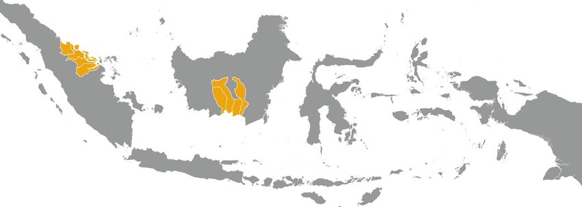
We selected eight districts for in-depth interviews with local
types are protected, what activities are allowed within
government officials. Districts were selected to represent
the IMM boundaries, and whether the IMM is avail-
ranges in moratorium coverage and historic deforestation
able in usable form at the local level.
rates, and based on ease of access.8 Interviews were conducted
Figure 1 | Districts Where Interviews Were Conducted
RIAU CENTRAL KALIMANTAN
Pelalawan; Bengkalis; Kapuas; Pulang Pisau; Katingan;
Siak; Rokan Hilir East Kotawaringin
Source: World Resources Institute.
4 |Indonesia’s Forest Moratorium: Impacts and Next Steps
2. Monitoring implementation of the moratorium: Awareness and understanding of the moratorium
identifying the agencies responsible for monitoring, and
assessing the process of monitoring; solicits open-ended Overall the local Forest Service (Dinas Kehutanan)
responses from these agencies regarding the challenges respondents from all eight districts demonstrated the
of implementing and monitoring the moratorium. clearest understanding of the moratorium, as shown in
Table 2. The Regional Development Planning Agencies
(BAPPEDA) and the Environmental Agencies (Badan
3. Enforcement of the moratorium: whether permits have
Lingkungan Hidup) also demonstrated awareness of
been denied since issuance of the moratorium, whether
the moratorium and understanding of the areas it pro-
there is knowledge of violations of the moratorium, and
tects and the types of activities it prevents. However, the
what recourse is available if violations are detected.
Agricultural Service (Dinas Pertanian) and the Integrated
Licensing and Investment Board (Kantor Perijinan Ter-
padu dan Badan Penanaman Modal Daerah) had very
limited knowledge of the moratorium, perhaps in part
because their national ministry counterparts were not
Table 1 | Agencies Interviewed and their Key included in the moratorium’s Presidential instruction.
Responsibilities under the Moratorium
Respondents from the Agricultural Service and the Inte-
grated Licensing and Investment Board demonstrated
RESPONSIBILITIES RELATED TO THE
AGENCY
IMPLEMENTATION OF THE MORATORIUM little working knowledge of the types of forests the mora-
torium protects or what activities it prohibits. This lack of
Regional Development ▪▪Overseeing and planning for regional knowledge is concerning given the role these agencies play
Planning Agency— development, including developing in critical activities related to the moratorium. For exam-
BAPPEDA low-emission spatial plans
ple, the Agricultural Service is tasked with mapping peat
▪▪ Allocating forest and nonforest land,
lands, and the Integrated Licensing and Investment Board
or reassigning these categories
is tasked with managing permit information. Because the
Forest Service— ▪▪Providing technical advice to licensing Agricultural Service and the Integrated Licensing and
Dinas Kehutanan requests in Forest Areas (Kawasan Hutan) Investment Board representatives gave limited answers,
and moratorium areas the detailed findings focus on responses from the For-
▪▪ Monitoring private sector activities in est Service, the Environmental Agency, and the Regional
Forest Areas (Kawasan Hutan)
Development Planning Agency.
Environment Agency— ▪▪Monitoring private sector activities on peat
Badan Lingkungan lands, including conducting environmental Respondents from the Forest Service, the key agency for
Hidup (BLH) impact assessments implementing the moratorium, in five out of eight districts
▪▪ Providing technical recommendations on permit knew the types of land the moratorium protects from new
applications, including consulting the IMM to conversion permits. However, only three districts out of
determine if the permit violates the moratorium
eight knew the specific locations of those areas within their
jurisdictions, and only one district had conducted field work
Agricultural Service— ▪▪Planning for agriculture areas, including to check the accuracy of the IMM. Other Forest Service
Dinas Pertanian consulting the IMM to determine if the
permit violates the moratorium respondents were aware of the website where the IMM
▪▪ Mapping peat land could be downloaded but had not yet done so.
Licensing and ▪▪Managing information on the location All respondents were generally aware of the moratorium,
Investment Board— and history of permits
Kantor Perijinan Terpadu but many did not learn about the proclamation in time to
dan Badan Penanaman properly implement the policy. Fourteen of 24 agencies
Modal Daerah learned of the initiative in 2011 when the president signed
the moratorium, while four Forest Service, four Envi-
ronmental Agency, and two Regional Planning Agency
respondents did not learn of the moratorium until 2012
during the second moratorium map revision.
WORKING PAPER | January 2014 | 5Table 2 | Awareness of Moratorium among Agencies in Eight Districts
DISTRICT PLANNING DISTRICT ENVIRONMENTAL AGRICULTURAL LICENSING AND
DISTRICT FOREST SERVICE
AGENCY AGENCY SERVICE INVESTMENT BOARD
Pelalawan
Siak
Bengkalis
Rokan Hilir
Kotawaringin Timur
Katingan
Kapuas
Pulang Pisau
emonstrated overall solid understanding.
D emonstrated moderate understanding.
D emonstrated limited understanding.
D
Clearly answered 5-6 questions. Clearly answered 3-4 questions. Clearly answered 1-2 questions.
Note: A scoring system was developed to compare knowledge of the moratorium among agencies and districts. The system took into account whether the respondents (1) were aware of the
moratorium, (2) knew the type of lands protected by the moratorium (3) had used the IMM to delineate areas protected by the moratorium in their district, (4) knew the activities permitted
by the moratorium, (5) knew what constituted a violation of the moratorium and (6) knew who was responsible for monitoring the moratorium.
In the absence of an effective awareness-raising campaign Enforcement of the moratorium
from the central government, it was up to the agencies’ own
initiative to learn about the moratorium. Six Forest Service The roles of the Forest Service, Environmental Agency,
and two Environmental Agency respondents learned about and Regional Planning Agency are generally to make tech-
the moratorium from the Ministry of Forestry website,9 nical recommendations regarding whether or not a land-
while four Forest Service, four Environmental Agency, and use permit application meets criteria for approval. Most
five Regional Planning Agency respondents learned from local government officials interviewed responded that
provincial department offices. All respondents stated that there had been no new permit applications, or that their
there was no formal outreach in their districts to dissemi- agency had not yet been asked to review new requests.
nate information on the moratorium. Forest Service respondents in four districts stated that
their agency was evaluating permit requests, primarily via
field checks, for peat lands. Forest Service respondents in
Monitoring implementation of the moratorium only two districts indicated that permits had been rejected
All local government respondents stated that they believed in their districts because of the moratorium.
there were no stipulated monitoring activities for which they
were responsible. Two respondents added that monitor- Respondents from three districts acknowledged forest loss
ing could not be conducted because no funding had been within the boundaries of the IMM, and stated that it was
allocated for monitoring activities. Four Forest Service, two caused by local people establishing farms and businesses.
Environmental Agency, and four Regional Planning Agency Respondents from two districts stated that violations were
respondents did not know who was responsible for conduct- observed, but that they were within legal permits issued
ing monitoring activities on the moratorium areas. The lack before the moratorium that may not have been incorpo-
of mandate, resources, and guidance for monitoring effec- rated into the IMM. Only one district acknowledged that a
tively prevents local agencies from enforcing the moratorium. violation occurred on land managed by a company, though
responses to this question could have been biased.10
In all eight districts at least one key agency had very limited
understanding of the moratorium and therefore presumably
was unable to contribute effectively to its implementation.
6 |Indonesia’s Forest Moratorium: Impacts and Next Steps
General recommendations from local 2 | REVIEW OF PROGRESS TOWARD THE
government agencies GOVERNANCE REFORMS OUTLINED BY
These findings demonstrate that district-level governments THE MORATORIUM
suffer from a lack of information about the moratorium,
which results in limitations on monitoring and enforcement. WRI and partners next asked: What are the statuses of
These challenges include limited access to up-to-date infor- the forest governance reforms proposed during the
mation, lack of implementation guidance, and the absence moratorium? Providing time to enable the implementa-
of a monitoring and enforcement mechanism to incentivize tion of forest governance reforms was a stated goal of the
compliance. Although the presidential instruction establish- moratorium. Reforms are needed to ensure long-term
ing the moratorium directs the Minister of the Interior to improvement in forest and land use management, reduce
provide guidance and oversight for local implementation of deforestation, and prevent greenhouse gas emissions.
the moratorium, a consistent mechanism to do so has not yet
been developed. As a result, the effectiveness of the morato- The presidential instruction establishing the moratorium
rium as estimated in Section 1 may be limited. explicitly mandated relevant government agencies to
improve forest governance14 through specific measures
At the district level, interview respondents indicated that coordinated by the Indonesian REDD+ Task Force under
the moratorium was a central government initiative with the Presidential Delivery Unit for Development Monitoring
little to no consultation with local government agencies.11 and Oversight (UKP4).15 These measures include instruc-
As a result, there was limited support at the district level tions to agencies for improving the process of issuing
for implementation, monitoring, or enforcement of the permits for conversion of forests, accelerating the spatial
moratorium. Recommendations from respondents for plan revision process, and strengthening spatial data
improving the effectiveness of the moratorium include: coordination and harmonization. The REDD+ Task Force
has also begun several initiatives to achieve these reform
goals, some of which were not explicitly mentioned in the
1. Improve vertical coordination between local
presidential instruction but are required to achieve overall
government agencies and national government
goals. WRI and partner organization Forest Watch Indone-
by disseminating information at the district level.
sia reviewed six key activities being coordinated by UKP4:16
2. Support incorporation of the IMM into the formal
1. Developing a centralized database for all geospatial
spatial planning process. This process determines
information in Indonesia (OneMap)
all zoning and land classification in the country and
is carried out at the national, provincial, and district
levels.12 This coordination is a critical step to achieve 2. Improving permit coordination and transparency
local compliance with the moratorium goals.
3. Strengthening the permit review process
3. The Ministry of Forestry should involve local district
agencies in creating and updating the IMM and pro- 4. Revising regulations on permits in forest areas
vide funding to carry out field work to ensure that the
IMM reflects the situation on the ground. The mora- 5. Accelerating the process of forest area gazettement
torium map is revised every six months with public
input through a website.13 However, local govern- 6. Including community maps in the formal spatial
ment respondents stated that there was little effort to planning process.
involve district governments in the moratorium map
development or revision process. We assessed progress on these governance reforms via
interviews with national and provincial government
4. The Ministry of Forestry or the REDD+ Task Force officials, and national nongovernmental organization
should develop and disseminate clear technical guid- representatives. Key activities were identified for each
ance, including roles and responsibilities of national, reform, and the progress of each activity was assessed.
provincial, and local government agencies, for moni- The progress in each activity over the past two years, and
toring and enforcing the moratorium. the work yet to be completed, is summarized and pre-
sented in more detail in Table 3.
WORKING PAPER | January 2014 | 7Table 3 | Summary of Geographic Scope and Progress of Ongoing Governance Reforms
REFORM GEOGRAPHIC SCOPE OF NEW INITIATIVE ASSESSMENT OF PROGRESS AS OF MAY, 2013
Developing a centralized database for all National initiative ▪▪Modest progress overall
geospatial information in Indonesia (OneMap) ▪▪National legal framework established
▪▪National implementing regulation issued
▪▪Substantial progress in Central Kalimantan
Improving permit coordination and Pilot in Central Kalimantan ▪▪Substantial progress in Central Kalimantan
transparency ▪▪Limited progress nationally
▪▪No national legal framework established
▪▪No national implementing regulations issued
Strengthening the permit review process Pilot in three districts in Central ▪▪Limited progress overall
Kalimantan ▪▪Substantial progress in pilot districts in Central Kalimantan
▪▪No national legal framework established
▪▪No national implementing regulation issued
Revising regulations on permits in forest areas National initiative ▪▪Modest progress overall
▪▪National implementing regulations issued
Accelerating the process of forest area Pilot in one district in Central Kalimantan ▪▪Modest progress overall
gazettement and national cooperation agreement ▪▪National legal framework established
▪▪National implementing regulations issued
▪▪Progress in pilot district in Central Kalimantan
Including community maps in the formal National initiative ▪▪Limited progress overall
spatial planning process ▪▪No national legal framework established
▪▪No national implementing regulations issued
▪▪Constitutional court ruling opens possibility of a national
legal framework
Source: The assessment of progress is a qualitative assessment based on the findings from the WRI study.
1. Developing a central database for all geospatial Status: The “One Map” Initiative aims to address this
information in Indonesia: The Indonesian govern- lack of clarity and consistency. “OneMap” is working
ment lacks an official central database of geospatial to bring together spatial data issued by 13 govern-
information, including base maps for land cover and ment agencies.19 This initiative is strengthened by Law
land allocation, on which to base land-use decisions. 4/2011, giving the Geospatial Information Agency
Each ministry has its own maps, which often do not the mandate to work with UKP4 and take the lead in
agree and frequently overlap, fueling potential conflict developing a single reference map20 for all spatial deci-
among agencies making land-use decisions such as sionmaking in the country. The agency is producing
issuing permits or designating protected areas.17 The detailed base maps on a 1:50,000 scale for the whole
discrepancies occur both between national ministries, country and integrating these with data from the 13
and among local, provincial, and national agencies. It participating agencies. The output of this work was
is common practice for the Ministry of Forestry, the expected by mid-2014. At an unspecified later date,
Ministry of Development Planning, the provincial gov- the Geospatial Information Agency must also build a
ernment, and the district head to all use different maps publicly accessible web-based portal to make all the
for the same geographic area.18 Improved data coor- maps and data available to the public.
dination, transparency, and access are fundamental
requirements for land-use decisionmaking and permit Obstacles: Before the law on geospatial information
granting aligned with climate and development goals. was signed in 2011, Indonesia had no mandate for
8 |Indonesia’s Forest Moratorium: Impacts and Next Steps
sharing geospatial data among government agencies.21 impact illegal permits. Additionally, in July 2013, the
While the new law represents a significant step for- Indonesian Parliament passed a new law “Preventing
ward, challenges to the development of a centralized and Eradicating Forest Destruction,” which further
spatial database include weak coordination among clarifies the definitions of forest violations in state
government agencies (both vertical and horizontal), forest areas, establishes a new agency to conduct
and no plan or mandate to incorporate subnational investigations of violations, and provides for a new
and district-level maps into the OneMap. ad hoc judge to tackle forest-related crimes.
2. Improving permit coordination and transparency: Obstacles: The lack of a specific mandate has been the
National agencies and local government offices often main challenge limiting comprehensive review of per-
do not share information on permits for logging, min- mits for compliance with Indonesian regulations. Other
ing, palm oil development, and other forest uses, or obstacles include a lack of technical guidance and data,
even spatial information more broadly. As a result, for example maps of peat land extent, as well as limited
multiple forest users may operate in the same area, legal recourse available if violations are identified.
creating confusion and conflict.
4. Revising regulations on permits in forest
Status: Indonesia’s REDD+ Task Force is capitalizing on areas: The permitting process in the forest area
the moratorium to develop an online database of all forest (kawasan hutan) suffers from several bureaucratic
licenses as part of the OneMap Initiative. The task force is challenges, including complex application processes,
focusing on Central Kalimantan, where a beta website is lack of transparency, and lengthy approval timelines.
being tested at the time of writing with an unknown target
date of completion. Status: During the moratorium the Ministry of For-
estry simplified the process for obtaining permits in
Obstacles: The challenges of coordination and trans- certain high-priority areas. Some of these steps have
parency are similar to those of developing a central- been positive, for example, the Ministry of Forestry
ized spatial database in general. These challenges reduced the number of steps necessary for ecosystem
include weak coordination laterally among govern- restoration permits within forest areas, an important
ment agencies, weak coordination between national type of permit for REDD+ projects.22 Other reforms
agencies and their subnational counterparts, and over- may have led to increased conversion of forest land
lapping mandates for granting permits. Overlapping and could be counterproductive to the country’s green-
mandates present a particular challenge since there house gas emissions reduction goals. For example, the
are several legal ways to acquire permits and multiple Ministry of Forestry added “areas needed for national
agencies may issue permits at the same time without food security” as a valid exception allowing permits
coordinating with each other. in protected forests,23 and the application process for
timber permits in Ministry of Forestry-defined natural
3. Strengthening the Permit Review Process: forests (hutan alam) was simplified. These new devel-
Government agencies, such as the District Heads or the opments suggest that harmonization of the goals of the
Ministry of Environment, do not regularly and consis- moratorium and REDD+ with other forest and land
tently review the compliance of permits with Indone- use regulations has not yet been a priority.
sian regulations. The neglected laws include regulations
limiting conversion of peat lands and the requirements Obstacles: Significant changes to regulations on per-
needed to obtain licenses within forest areas. mits in forest areas are limited by pressures and inter-
ests from various stakeholders in the policymaking
Status: The REDD+ Task Force is piloting a new process. As a result the revisions thus far have been a
review process in the districts of South Barito, Kapuas, mix of environmentally progressive rules and regula-
and East Kotawaringin in Central Kalimantan. A law tions, and revisions that are unlikely to reform key
firm has been contracted to assess the legality of exist- sectors with strong vested interests. Another key chal-
ing permits in these districts, and a memorandum of lenge is the lack of transparency, which contributes to
understanding has been signed with district officials. rent-seeking behavior in the permitting process.
However, it is unclear if or how this assessment will
WORKING PAPER | January 2014 | 95. Accelerating the process of forest area ing community input into account, the national govern-
gazettement, delaying spatial plans: Indonesia, ment is missing the opportunity to incorporate detailed,
like many nations, designates “official” forest land as up-to-date information about the state of natural
a “forest area” (kawasan hutan). The designation of resources that could be provided by local communities.
“forest area” provides the foundation for deciding what This information can be vital to ensuring that spatial
types of forest use can occur and where. It is a critical plans on paper match reality on the ground.
first step for improving land-use planning and forest
management. A 2011 Constitutional Court Decision Status: During the moratorium, the REDD+ Task
fundamentally changed the process for establishing for- Force invited civil society through both electronic com-
est areas, stating that all forest area must be “gazetted,” munications (email and website) and workshops to sub-
or officially mapped; beyond being designated by the mit community maps and land-use plans,30 a primary
Ministry of Forestry.24 However, as of February 2012, means for adat communities to articulate their legal
only 11 percent of Indonesia’s 130.7 million hectares of claims. Thus far, 265 community maps covering 2.4
forest area had been gazetted.25 The extent and alloca- million hectares have been submitted, yet it is unclear
tion of Indonesia’s forest area continues to be the major whether or how this information has been used.
point of contention that stalls the development of more
specific provincial and district-level spatial plans. As of In addition, a May 2013 Constitutional Court ruling
May 2013, only 45 percent of provinces and 60 percent declared unconstitutional the articles in the 1999
of the districts had finalized their spatial plans.26 Forestry Law that categorized customary land areas
as part of Ministry of Forestry-controlled forest area.31
Status: The moratorium allows the REDD+ Task Force, This landmark legal ruling mandates the government
in collaboration with the Ministry of Forestry and local to ensure formal recognition of community-made maps
governments, to pilot measures to overcome conflicts and and plans. In June 2013, the Indonesian president pub-
accelerate gazettement of forest areas. The task force has licly voiced his commitment to recognizing Indonesia’s
begun work in South Barito district, Central Kalimantan. traditional communities.32
Methods to speed up the gazettement process, such as
conducting a multistakeholder meeting to discuss boundar- Obstacles: Historically, there has been little incentive
ies of forest areas, and developing an agency to guide the for the national government to recognize the rights of
process,27 are being tested. Twelve agencies in the Indone- local communities over their traditional lands. This
sian government signed an agreement in March 2013 to situation is slowly changing, but the legal mechanism
accelerate the forest gazettement process.28 and implementing regulations to incorporate com-
munity maps into the formal spatial planning process
Obstacles: The gazettement of the forest area has remains unclear.
been delayed principally by disagreement between
national and subnational entities regarding jurisdic-
tion of land use decisionmaking. Since decentraliza-
RECOMMENDATIONS AND NEXT STEPS
tion, which made subnational control possible, began The findings of this research demonstrate that the mora-
in the early 2000s, the national Ministry of Forestry torium was a key strategic step in the right direction for
has been reluctant to cede power over land-use deci- Indonesia to improve land-use management and reduce
sions to local entities while local governments are greenhouse gas emissions from deforestation and peat
similarly reluctant to cede control of land-use deci- land conversion.
sions to the national level.
Fundamental governance reforms are key to achieving
6. Including community maps in the formal spatial deeper emissions reductions to set the country on a low-
planning process: Lands occupied by local, traditional emissions development trajectory. One of the ultimate
communities, known as adat areas, have historically goals of the moratorium is to establish robust governance
gone unrecognized in Indonesia’s formal spatial plan- systems so that when the moratorium is lifted, forest
ning system.29 Ignoring adat communities’ land rights management and land use will not revert to business as
spurs poverty, hinders economic development, and usual. Our analysis provides insights on some priority next
deters environmental stewardship. Further, by not tak- steps during the next two years to best take advantage of
10 |Indonesia’s Forest Moratorium: Impacts and Next Steps
the window of opportunity provided by the moratorium to to obtain a forest license— is being coordinated by
achieve this goal. These recommendations include: UKP4. Such a review process will be facilitated by
the ongoing steps to improve data availability under
1. Improve awareness of the moratorium at the OneMap. This step should be followed by a stronger
local level. The current moratorium is limited by lack mechanism to revise or cancel permits found to be in
of awareness and technical guidance for implementa- noncompliance with the law.
tion, monitoring, and enforcement at the local level.
Ensuring a basic level of understanding at the district 5. Designate forest areas. A slow gazettement of
level will be a critical next step for boosting the morato- official “forest areas” has stalled the development of
rium’s application. This awareness can be accomplished district and provincial land use plans, which provide
if the central government conducts broad outreach and the foundation for land-use planning in the country.
disseminates technical guidance to the district level. New mechanisms to overcome the conflicts slowing
The Ministry of Interior, tasked by the presidential forest area gazettement are in the pilot phase. Lessons
instruction with providing guidance and oversight learned from this pilot phase should be compiled by
for local implementation of the moratorium, should the Ministry of Forestry, scaled up, and applied to the
improve outreach targeted at local forest services, rest of the country.
planning agencies, and environment agencies. Target-
ing in-depth outreach efforts specifically at districts 6. Formalize community plans. Creating a mecha-
with historically high deforestation may be an efficient nism for formal acceptance of community maps will
approach because the majority of observed violations of invite a new flow of detailed information that can
the moratorium occur within just a few districts.33 improve spatial planning for local communities and
the nation. During the moratorium, the REDD+ Task
2. Increase local government participation. Accord- Force invited the submission of community maps and
ing to local government agencies, a key improvement land-use plans. This is a step in the right direction for
needed during the moratorium is more widespread recognition of Indonesia’s customary communities.
involvement of local agencies in updating the mora- However, government ministries must provide further
torium map, and incorporating it into formal and clarity on the legal mechanism and implementing
long-lasting spatial plans. Participation of local regulations for incorporating community maps into
governments, including local forest services, plan- the formal spatial planning process.
ning agencies, and environment agencies, should be
a priority for the Ministry of Forestry as it updates 7. Evaluate greenhouse gas emissions dur-
the map. Improving participation will be critical to ing permitting. The new online permit database,
ensuring alignment of the maps with the situation on coordinated by the Geospatial Information Agency,
the ground, and will ensure sufficient buy-in from key OneMap, should incorporate data on forest cover, peat
local actors to achieve effective implementation. land extent, and carbon stocks to enable accounting
for greenhouse gas emissions risks. Such a system
3. Continue permit coordination and transparency. can also support efforts to shift agricultural expan-
The Geospatial Information Agency’s work to develop sion from forested land to non-forested “degraded
an online, publicly accessible database of all provincial land,”34 a key component of low-emissions agricultural
forest licenses–also commonly called OneMap–should development. Importantly, outreach to local govern-
be expanded to Indonesia’s remaining 33 provinces. ment agencies that are partly responsible for permit
Mandates to increase transparency and harmonize application and review will be a key component of this
permit data between national, provincial, and district type of permitting reform.
governments should be systematically expanded to the
rest of the country. 8. Monitor impacts of governance reforms. A prin-
cipal goal of the moratorium should be to strengthen
4. Strengthen the permit review process. The devel- governance so that when the moratorium is lifted,
opment of a new review process to evaluate permit forest management and land use will not revert to
compliance with Indonesian regulations—such as the business as usual. Whether or not the moratorium
limits on converting peat lands and the steps required succeeds in setting the country on a low-emissions
WORKING PAPER | January 2014 | 11development trajectory will depend on the effective- APPENDIX 1. LIST OF DISTRICT
ness of current reforms. We propose that the new
REDD+ Agency continue the work of the REDD+ Task INTERVIEW QUESTIONS
Force in identifying indicators of progress toward, and Puter Foundation Indonesia used the interview questions below in interviews
the impacts of, these governance reforms. Addition- with various government officials in the agencies described in Table 1 in
ally, the agency can put in place systems to monitor March 2013. This interview concentrated on eight districts in two provinces
(Central Kalimantan and Riau). WRI compiled the findings into insights and
these indicators over time, and report their findings recommendations for this report.
so the government can learn from its experiences and
engage in results-based policymaking. Awareness
1. Did you know there is a moratorium on new licenses in peat land and
Curbing deforestation, reducing emissions, and improving primary forests? Where and when did you first hear about this news?
quality of life for millions of Indonesian citizens hinges on 2. Do you know which areas in your district are included in the
sound forest governance. Extending the moratorium for moratorium map? How do you know where these areas are?
two more years does not guarantee more emissions reduc- Has there been any information dissemination process of the
tions or better forest management, but it is a critical start- presidential instruction?
ing point. Indonesia can now implement much-needed 3. Do you know what activities are permissible within the moratorium
land-use reforms by seizing the rare opportunity provided area? How do you know? Was this information included in an
by the moratorium. information dissemination process?
Monitoring
1. Which department or agency is responsible for monitoring the imple-
mentation of the moratorium? How do they conduct monitoring?
2. Did your agency ever do field work related to monitoring the morato-
rium? Was this conducted in cooperation with the federal government?
3. In general, what are the constraints faced when implementing a mora-
torium on new licenses?
Enforcement
1. Did you ever reject a permit because of the moratorium? What was
the reason for the refusal?
2. Are you aware of any violation of the moratorium within the district?
What type of permit did the entity responsible for the violation hold?
3. What are the criteria for a violation of the moratorium? Who (which
agency/agencies) developed this criteria? Who approved the criteria?
4. In case of violation of the moratorium, to whom (which agency/agen-
cies) is the violation reported? Who is responsible for reporting the
violation? What is the process after reporting?
5. Have there ever been reports of violations by NGOs or other
institutions? In these cases what action was taken?
6. Were there any objections or complaints from companies regarding
the moratorium?
12 |Indonesia’s Forest Moratorium: Impacts and Next Steps
ENDNOTES
1. Fogarty 2009. Geophysics Agency maps; and Aerospace Agency maps.
2. DNPI 2010. 20. Base maps in the 1:50,000 scale to be produced by BIG include information
3. Maulia 2010. on land cover; rivers, coasts, and other water bodies; altitude; significant land
4. Presidential Instruction 10/2011, available at http://www.kemendagri. marks and buildings; road, rail, and other transportation infrastructure; and
go.id/media/documents/2011/09/19/i/n/inpres_no.10-2011.pdf administrative boundaries with consistent names for all attributes. Source:
5. Gingold et al. 2012. BIG website, accessible at http://www.bakosurtanal.go.id/peta-rupabumi/.
6. All land, water, and natural resources in Indonesia are designated as 21. The Indonesian Law on Geospatial Information (UU 4/2011)
either within the forest area (kawasan hutan) or non-forest area (area regulates how different Indonesian government agencies share and
penggunaan lain). Forest areas fall under the jurisdiction of the national use spatial data for policymaking purposes. Available at http://www.
Ministry of Forestry; non-forest areas fall under the jurisdiction of the bakosurtanal.go.id/assets/download/UU_IG/UU%20NO%204%20
local district government under local autonomy policy. THN%202011%20TENTANG%20INFORMASI%20GEOSPASIAL.pdf
7. Barr et al. 2006. 22. The Minister of Forestry Regulation 26/2012 revises Minister of
8. Chosen districts have between 15% and 65% of their total area covered Forestry Regulation 50/2010. It reduced two steps that are required to
under the moratorium. apply for an ecosystem restoration concession.
9. Ministry of Forestry’s website www.dephut.go.id. 23. This exception includes a requirement to empower communities and
10. This violation was reported by the local government to the UKP4 task restore ecosystem services when a special permit’s lease expires.
force for law enforcement, but the details are not publically available. 24. According to Law 41/1999 on forestry, the gazettement of forest areas
11. According to Indonesian law on subnational governments (Law 32/2004), or pengukuhan kawasan hutan must progress through four steps: (1)
the local government (district/municipality or kabupaten/kota) is independent forest area designation, (2) forest area boundary demarcation, (3) forest
from the central government and the district head is directly elected by the area mapping, and (4) forest area stipulation. The constitutional court
district’s constituents. Provincial governments have the mandate to report to decision further strengthened this regulation.
the president, but the districts do not. It is unclear how much cooperation be- 25. Wells et al. 2012.
tween the different layers of government is required by the law and enforced. 26. Database Status Perda RTRW Provinsi/Kabupaten/Kota. Direktorat
For more information see Law 32/2004, available at http://www.kpu.go.id/ Jenderal Penataan Ruang, Kementerian Pekerjaan Umum. Available at
dmdocuments/UU_32_2004_Pemerintahan%20Daerah.pdf http://www.penataanruang.net/informasi.asp#fragment-11
12. For more information on the Indonesian spatial planning process, refer 27. The governor of Central Kalimantan officially requested the Ministry of
to Law 26/2007, available at http://www.bkkbn.go.id/jdih/Peraturan%20 Forestry to establish this agency. As of March 2013, his request was
PerundangUndangan%20Pusat/UU%20No.26-2007%20penataan%20 being reviewed by the Ministry for State Reform.
ruang.pdf 28. Geospatial Information Agency (Badan Informasi Geospasial: BIG)
13. Public input for the moratorium map was posted on the REDD+ Task website, http://www.bakosurtanal.go.id/berita-surta/show/penan
Force’s website, available at www.satgasreddplus.org. datanganan-nota-kesepakatan-tentang-reformasi-tata-kelola-sektor-
14. The mandates were laid out in a Presidential Instruction kehutanan.
document, available at http://www.kemendagri.go.id/media/ 29. This system is referred to as the Rencana Tata Ruang Wilayah (RTRW).
documents/2011/09/19/i/n/inpres_no.10-2011.pdf 30. Documentation can be accessed through the REDD+ Task Force’s
15. The Indonesian REDD+ Task Force is an Indonesian government body estab- press release, available at http://www.satgasreddplus.org/down-
lished through Presidential Regulation 19/2010 with the task to coordinate load/20121113_PERS_RELEASE_Indigenous_Map_integrated_in_
all REDD+ related activities in the country. More information is available at One_Map_ENG.pdf
http://www.satgasreddplus.org/en/. In September 2013, the President signed 31. Constitutional Court Decision 35/2013, see Jakarta Globe article
a decree establishing a managing agency for REDD+ that has the mandate by Pasandaran (2013) available at http://www.thejakartaglobe.com/
to, among many things, develop a national REDD+ strategy and policies; de- news/constitutional-court-annuls-government-ownership-of-
velop REDD+ safeguards; manage REDD+ funding and benefits distribution; customary-forests/
coordinate GHG measurement and monitoring, reporting, and verification; 32. The Indonesian President was quoted as saying, “I am personally committed
and build the capacity of other ministries and agencies to implement REDD+ to initiating a process that registers and recognizes the collective ownership
activities. More information is available at http://www.thejakartapost.com/ of adat territories in Indonesia. This is a critical first step in the implementa-
news/2013/09/08/government-officially-forms-redd-agency.html. tion process of the Constitutional Court’s decision.” Cabinet Secretariat, Re-
16. This is not an exhaustive list of the activities being carried out to ad- public of Indonesia website, “President SBY and CEO Polman Urge Business
vance REDD+ readiness and forest governance reform in the country. Sector and Civil Society to Achieve Sustainable Growth at TFA 2020,” June
17. One documented example can be seen in UKP4’s comparison of the 27, 2013, available online at http://www.setkab.go.id/international-9290-.html
Ministry of Forestry and Ministry of Environment’s land cover map for 33. Unpublished research by WRI shows that 75 percent of large-scale defor-
the island of Papua. estation events occurred within just 20 districts during the moratorium.
18. World Resources Institute. “Comparison of Ministry of Forestry 2010, 34. Gingold et al. 2012.
Ministry of Forestry 2013, and Provincial 2013 Maps.” Unpublished.
19. OneMap will include information from: national land registry maps;
Department of Interior maps; infrastructure and transport data; com-
munication and IT maps; Ministry of Public Works maps; Ministry of
Culture and Tourism maps; Statistics Agency maps; Ministry of Energy
and Mineral Resources maps; Ministry of Forestry maps; Ministry of
Agriculture maps; Ministry of Marine Affairs maps; Meteorology and
WORKING PAPER | January 2014 | 13REFERENCES
Austin, K., F. Stolle, S. Sheppard. 2012. “Indonesia’s Moratorium on New Forest Con- Murdiyarso, D., S. Dewi, D. Lawrence, and F. Seymour. 2012. “Indonesia’s
cessions.” Working Paper. World Resources Institute, Washington, D.C. Accessible Forest Moratorium: A Stepping Stone to Better Forest Governance?” Center
at: http://www.wri.org/publication/indonesias-moratorium-new-forest-concessions for International Forestry Research (CIFOR), Bogor, Indonesia. Accessible at:
http://www.cifor.org/publications/pdf_files/WPapers/WP-76Murdiyarso.pdf
Barr, C., I. A. P. Resosudarmo, A. Dermawan, J. McCarthy, M. Moeliono,
B. Setiono (eds.) 2006. Decentralization of Forest Administration in Indonesia: Pasandaran, C. 2013. “Constitutional Court Annuls Government Ownership
Implications for Forest Sustainability, Economic Development and Community of Customary Forests.” The Jakarta Globe. May 17, 2013. Accessible at:
Livelihoods. Bogor, Indonesia: Center for International Forestry Research http://www.thejakartaglobe.com/news/constitutional-court-annuls-govern-
(CIFOR). Accessible at http://www.cifor.org/publications/pdf_files/Books/ ment-ownership-of-customary-forests/
BBarr0601.pdf
REDD+ Task Force, Republic of Indonesia. 2012. “Indigenous Map Integrated
BIG (Badan Informasi Geospasial Geospatial Information Agency), Republic into OneMap.” Press Release, November 14, 2012. Accessible at http://www.
of Indonesia. 2013. “Penandatanganan Nota Kesepahaman Bersama Tentang satgasreddplus.org/download/20121113_PERS_RELEASE_Indigenous_
Reformasi Tata Kelola Sektor Kehutanan.” BIG News Portal. Undated. Map_integrated_in_One_Map_ENG.pdf
Accessible at http://www.bakosurtanal.go.id/berita-surta/show/
penandatanganan-nota-kesepakatan-tentang-reformasi-tata-kelola- Republic of Indonesia. 2011. “Instruksi Presiden nomor 10 tahun 2011.”
sektor-kehutanan Presidential Instruction number 10/2011. Accessible at
http://www.kemendagri.go.id/media/documents/2011/09/19/i/n/inpres_
DNPI (Dewan Nasional Perubahan Iklim). 2010. Indonesia’s Greenhouse Gas no.10-2011.pdf
Abatement Cost Curve. Indonesian National Climate Change Council, Jakarta,
Indonesia. Accessible at: http://www.dnpi.go.id/ report/DNPI-Media-Kit/reports/ Republic of Indonesia. 2011. “Undang-Undang nomor 4 tahun 2011 tentang
indonesia-ghg_abatement_ cost_curve/Indonesia_ghg_cost_curve_english.pdf Informasi Geospasial.” Law number 4/2011 on Geospatial Information.
Accessible at http://www.bakosurtanal.go.id/assets/download/UU_IG/UU%20
Fogarty, D. “Indonesia CO2 Pledge to Help Climate Talks.” Reuters.com NO%204%20THN%202011%20TENTANG%20INFORMASI%20GEOSPASIAL.pdf
September 29, 2009. Web.
Republic of Indonesia. 2007. “Undang-Undang nomor 26 tahun 2007 tentang
Gingold, B., A. Rosenbarger, Y.I. K. D. Muliastra, F. Stolle, I. M. Sudana, M. Penataan Ruang.” Law number 26/2007 on Spatial Planning. Accessible at
D. M. Manessa, A. Murdimanto, S.B. Tiangga, C. C. Madusari, and P. Douard. http://www.bkkbn.go.id/jdih/Peraturan%20PerundangUndangan%20Pusat/
2012. “How to Identify Degraded Land for Sustainable Palm Oil in Indonesia.” UU%20No.26-2007%20penataan%20ruang.pdf
Working Paper. World Resources Institute and Sekala, Washington, D.C.
Accessible at http://wri.org/publication/identifying-degraded-land- Republic of Indonesia. 2004. “Undang-Undang nomor 32 tahun 2004 tentang
sustainable-palm-oil-indonesia. Pemerintahan Daerah.” Law number 32/2004 on Subnational Government.
Accessible at http://www.kpu.go.id/dmdocuments/UU_32_2004_Pemerintahan
“Government Officially Forms REDD Agency.” The Jakarta Post. September %20Daerah.pdf
8, 2013. Accessible at http://www.thejakartapost.com/news/2013/09/08/
government-officially-forms-redd-agency.html Republic of Indonesia. 1999. “Undang-Undang nomor 41 tahun 1999 tentang
Kehutanan.” Law number 41/1999 on Forestry. Accessible at: http://prokum.
Maulia, E. 2010. “Indonesia Pledges to ‘Feed the World.’” The Jakarta esdm.go.id/uu/1999/uu-41-1999.pdf
Post. January 30, 2010. Accessible at: http://www.thejakartapost.com/
news/2010/01/30/indonesia-pledges-feed-world039.html Thamrin, Syamsidar. 2011. “Indonesia’s National Mitigation Actions:
Paving the way towards NAMAs.” Discussion document. Accessible at:
Ministry of Forestry, Republic of Indonesia. 2012. “Peraturan Menteri Kehutanan http://www.oecd.org/env/cc/48304156.pdf.
nomor 26 tahun 2012 Perubahan Atas Peraturan Menteri Kehutanan Nomor P.50/
Menhut-II/2010 Tentang Tata Cara Pemberian dan Perluasan Areal Kerja Izin Usaha Wells, P., N. Franklin, P. Gunarso, G. Paoli, T. Mafira, D.R. Kusumo, B.
Pemanfaatan Hasil Hutan Kayu (IUPHHK) Dalam Hutan Alam, IUPHHK Restorasi Clanchy. 2012. “Indonesian Constitutional Court Ruling Number 45/PUU-
Ekosistem, Atau IUPHHK Hutan Tanaman Industri Pada Hutan Provinsi.” Minister IX/2011 in Relation to Forest Lands: Implications for Forests, Development
of Forestry Regulation number 26/2012, revising Minister of Forestry Regula- and REDD+”. Daemeter Consulting Policy Brief. Bogor, Indonesia. Accessible
tion number 50/2010 on the Granting and Expansion of timber permits in natural at: http://www.daemeter.org/wp-content/files/Policy_Brief_Constitutional_
forests, ecosystem restoration permits, and timber permits in industrial forests. Court_Decision_No_45_PUUIX_2011.pdf.
Ministry of Public Works, Republic of Indonesia. “Database Status Perda
RTRW Provinsi/Kabupaten/Kota.” Direktorat Jenderal Penataan Ruang,
Kementerian Pekerjaan Umum. Accessible at http://www.penataanruang.net/
informasi.asp#fragment-11.
14 |You can also read