Integrating dairy and hill country farming with forestry for profitable and sustainable land use Case Study 5: Ngāti Awa Farms Ltd - Report ...
←
→
Page content transcription
If your browser does not render page correctly, please read the page content below

Integrating dairy and hill
      country farming with
forestry for profitable and
      sustainable land use

            Case Study 5:
     Ngāti Awa Farms Ltd

                 Report prepared by
          Perrin Ag Consultants Ltd
                    4 February 2020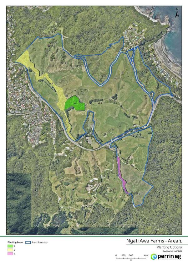
Prepared by Perrin Ag Consultants Ltd
Registered Farm Management Consultants
1330 Eruera Street, PO Box 596
Rotorua 3010
New Zealand

Phone: +64 7 349 1212
Email: consult@perrinag.net.nz
www.perrinag.net.nz

This Report makes certain information and material available to you as a service.

The content of this Report is based on the information provided to Perrin Ag and other information currently
available to Perrin Ag, and is only intended for use by the parties named in it.

Unless expressly stated otherwise in this Report, Perrin Ag will have no liability whatever to any person in respect
of any loss or damages arising from the information contained in this Report, or in respect of any actions taken in
reliance on such information (which actions are taken at your sole risk). You acknowledge that Perrin Ag does not
proffer an opinion with respect to the nature, potential value, financial viability or suitability of any farming activity,
transaction or strategy referred to or connected with this Report.

Due care has been taken by Perrin Ag in the preparation of this Report. Notwithstanding, Perrin Ag does not
provide any warranty as to the accuracy, reliability or suitability for any purpose of the information and advice
contained in the Report, whether to you or to any other person.

To the fullest extent permitted by law Perrin Ag will not be responsible for any errors or misstatements in this
Report, or be liable - whether in contract, tort (including negligence) or otherwise - for any loss or damage you may
incur as the result of any such errors or misstatements (including direct, indirect, consequential or special loss, or
any loss of profits).
Document Quality Assurance

                                  Daniel Payton
Prepared by:                      BComAg (FM), NZIPIM
                                  Senior Consultant

                                  Carla Muller

Reviewed by:                      BApplEcon, MEnvMgmt (Hons),
                                  MNZIPIM, ASNM
                                  Senior Consultant
                                  Lee Matheson
                                  BApplSc (Hons), NZIPIM (Reg.),
Approved for release by:
                                  ASNM
                                  Managing Director

Status:                           FINAL

Bibliographic reference for citation:

Payton D. Case Study 5: Ngāti Awa Farms Ltd, Integrating dairy and hill country farming with forestry
for profitable and sustainable land use. Report prepared by Perrin Ag Consultants Ltd for Te Uru
Rākau. February 2021. 58 pages.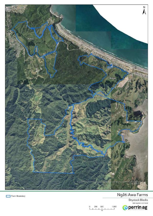
Executive Summary
This report explores the process involved with making forestry planting decisions that are aligned
with a landowner's objectives. Three scenarios were analysed showing:
i. The implications for a landowner deciding to replant existing Pinus radiata rotations with an
alternative species.
ii. Replanting decisions for underutilised non forest land and their relevance to funding or grant
programmes and the Emissions Trading Scheme (ETS).
iii. How riparian planting for landscape enhancement and sustainability can be planned to meet
eligibility criteria similar to the recent One Billion Trees programme and the Emissions Trading
Scheme.
Te Rūnanga o Ngāti Awa, through their farming company Ngāti Awa Farms Ltd, own an 1,117
hectare drystock hill country sheep and beef breeding and finishing unit surrounding the
Whakatāne Township in the Eastern Bay of Plenty. They are also majority shareholders in a
partnership with other hapū trusts in a 204 hectare dairy unit near Te Teko on the Rangitāiki plains
and a 340 hectare dairy unit near Rotomā.
Ngāti Awa have stands of Pinus radiata on their drystock property that they have identified for
replanting in alternative species. Some sites are unsuitable for pine and they do not see pine
forestry as a core business for their farms as they already have significant pine forestry investments
elsewhere.
Ngāti Awa actively seek to reduce the environmental footprint of their farming operations and farm
in a sustainable manner. Options for retiring land that enhances their properties from an
environmental, financial, aesthetic and cultural viewpoint are actively considered.
The visions, goals and values of Ngāti Awa Farms Ltd encompass that of the traditional Māori values
of mana, mauri, whakapapa and tapu. They are central to Ngāti Awa's relationship with the natural
environment and are also interconnected with the iwi’s other social and cultural values. These
values form the decision making framework for business strategy and policy decisions.
The criteria for identifying and selecting potential planting sites referenced the strategy and values
of Ngāti Awa. A total of 11 individual sites were identified across the three properties. Species
selection was based on the mantra of "right tree, right place" with more weighting placed on
species that could resonate with Ngāti Awa values and provide landscape enhancement, cultural
value and ongoing employment for hapū through silviculture or alternative income streams.
The species chosen were totara (Podocarpus totara) and coast redwood (Sequoia sempervirens) for
timber production. Mānuka (Leptospermum scoparium) and kawakawa (Piper exelsum) were chosen
as cover crops to colonise the bare land prior to planting timber species. Mānuka was also chosen
as a single species on one site for mānuka oil production.
Three scenarios were chosen from the site and species options to examine, at a high level, the
process and implications for replanting current forest areas in alternative species (scenario 1),
identifying and planting riparian areas (scenario 3) and planting options for underutilised land
(scenario 2).
Pōhutukawa (Metrosideros excels) and kahikatea (Dacrycarpus dacrydioides) were chosen as
alternatives to the above mentioned timber species; their main attributes being aesthetics and
cultural value. Modern cultivars of poplar (Populus genus) were selected for erosion control and a
mixture of native species for riparian planting or landscape enhancement.
Page 4 of 58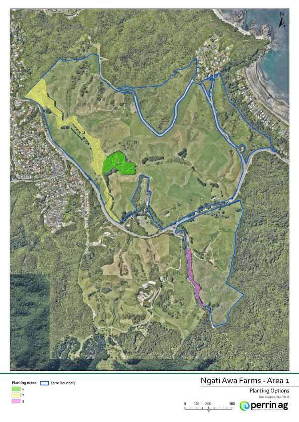
Scenario 1 highlighted that the decision to replant Pinus radiata with alternative species has
implications surrounding carbon liability and future carbon earning potential depending on the
forest’s age, species and definition within the ETS framework. A clear advantage was identified for
native forests using the Field Measurement Approach (FMA) method for measuring carbon stock
compared to the MPI default lookup tables. The potential premium of carbon credits from native
forests were discussed as was the alternative income streams from honey and the medicinal value
of mānuka and kawakawa cover crops.
The outcome of scenario 2 was that despite meeting most of the criteria the same as the One
Billion Trees programme and ETS criteria, mānuka planting for oil production was not eligible for
inclusion in the ETS as the mānuka would be managed in a way, through the harvesting of foliage,
that would limit forest height and canopy cover. There was potential to replace the barberry
hedgerows on the Ngakauroa Dairy unit with mānuka; harvesting the foliage would allow the centre
pivot irrigator to pass over and the mānuka trees would provide stock shelter and an aesthetic
value.
Scenario 3 examined potential riparian planting sites. Two examples from the Ngāti Awa drystock
property were used to show that riparian planting for landscape enhancement and sustainability, if
planned correctly, can meet the objectives of funding programmes and the ETS.
This case study has shown that the decision to replant pine forest with alternative species can be
complex with implications around carbon liability and future carbon earning potential depending
on how the pine forest is defined within the ETS, the subsequent forest species rotation and the
methodology used to measure carbon stock. Due to this complexity landowners are advised to seek
the relevant professional advice when making replanting decisions.
This is equally important when undertaking a financial analysis on planting options, it was
considered beyond the scope of this report yet due to the expense of planting trees and long term
nature of the investment, the need for a robust plan and financial analysis cannot be emphasised
enough.
Replanting pine with natives or coast redwood is an intergenerational investment due to the long
rotation length (80 - 120 years for natives, 50 years or greater for redwood heartwood production).
An investment analysis must account for other inherent benefits (including cultural, biodiversity and
landscape enhancement benefits) when comparing the investment against shorter Pinus radiata
term rotations.
Page 5 of 58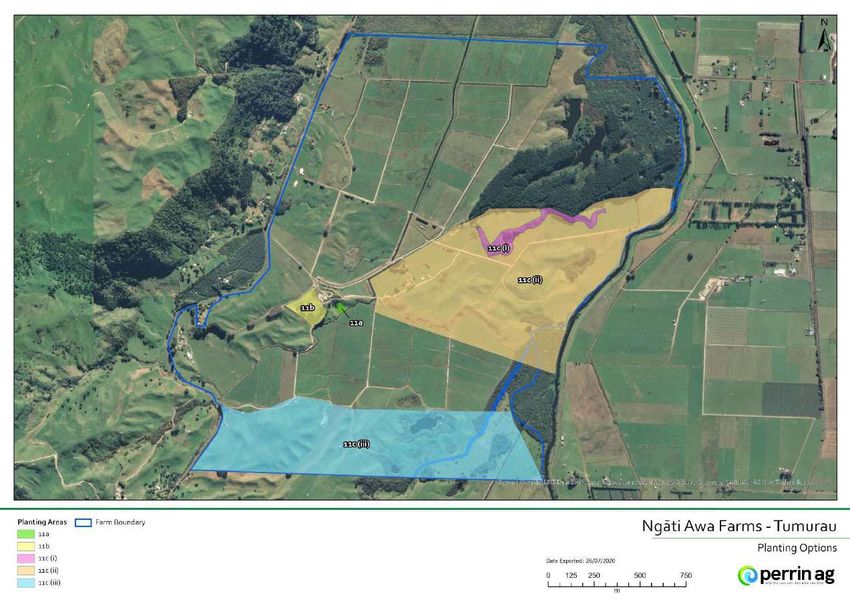
CONTENTS
DOCUMENT QUALITY ASSURANCE ....................................................................................................................... 3
EXECUTIVE SUMMARY ............................................................................................................................................ 4
INTRODUCTION ....................................................................................................................................................... 8
METHODOLOGY ...................................................................................................................................................... 9
         Process ........................................................................................................................................................... 9
SECTION 1: FARM AND BUSINESS DESCRIPTION .............................................................................................. 10
         Introduction ................................................................................................................................................ 10
         Business strategy........................................................................................................................................ 11
                 Vision and goals .................................................................................................................................. 11
         Farm description ........................................................................................................................................ 14
                 Ngāti Awa Drystock Farm .................................................................................................................. 14
                 Ngakauroa dairy ................................................................................................................................. 15
                 Tumurau dairy .................................................................................................................................... 15
                 Current Plantings ............................................................................................................................... 17
                 Site Selection Criteria ......................................................................................................................... 18
                 Replanting existing woodlots with alternative species ................................................................. 18
                 Environmentally sensitive areas....................................................................................................... 19
                 Underutilised land .............................................................................................................................. 19
                 Overview of sites ................................................................................................................................ 20
SECTION 2: FORESTRY OPTIONS ......................................................................................................................... 24
         Species Selection ........................................................................................................................................ 24
                 The species selected .......................................................................................................................... 24
                 Totara .................................................................................................................................................. 24

                 Coast Redwood .................................................................................................................................. 24

                 Pōhutukawa and Kahikatea .............................................................................................................. 25

                 Mānuka and Kawakawa .................................................................................................................... 25

                 Poplar .................................................................................................................................................. 25

SECTION 3: SCENARIO ANALYSIS ........................................................................................................................ 26
         An overview of forestry in the Emissions Trading Scheme (ETS) ......................................................... 27
         Scenario 1: Replanting radiata pine stands with native or exotic species .......................................... 30
                 Eligibility for funding with the same criteria as 1BT ...................................................................... 30
                 Pre 1990 forest ................................................................................................................................... 30
                 Post 1989 ETS registered forests ..................................................................................................... 31
                 Implications for NZU allocation and liabilities, mandatory emissions return periods ............. 33

                                                                                                                                                        Page 6 of 58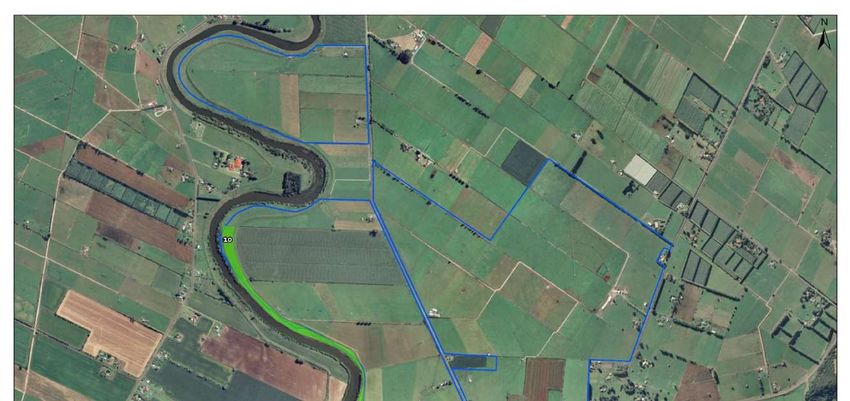
Post 1989 forests registered in ETS Example 2: Effect of species on tradeable carbon. ......... 34
                 MPI default Carbon Look-Up Tables versus Field Measurement Approach .............................. 36
                 Post 1989 forest not registered in the ETS ..................................................................................... 37
                 Entering second rotation forest in the ETS ..................................................................................... 37
                 Carbon stock change vs. carbon average accounting ................................................................... 39
         Scenario 2: Planting mānuka for oil production .................................................................................... 40
                 Planting ................................................................................................................................................ 41
                 Harvesting ........................................................................................................................................... 41
                 Markets ................................................................................................................................................ 42
                 Eligibility for funding with same criteris as 1BT ............................................................................. 42
         Scenario 3: Riparian planting for same as 1BT funding, and ETS eligibility........................................ 43
                 Drystock property .............................................................................................................................. 43
                 Ngakauroa and Tumurau dairy units .............................................................................................. 43
                 Eligibility criteria for direct grants the same as 1BT scheme ....................................................... 45
                 Eligibility for the Emissions Trading scheme .................................................................................. 46
                 Funding categories ............................................................................................................................. 46
                 Payment of funding grants ............................................................................................................... 46

                 Milestone 1 ......................................................................................................................................... 46

                 Milestone 2 ......................................................................................................................................... 46

                 Milestone 3 ......................................................................................................................................... 46

SECTION 4: DISCUSSION AND CONCLUSION .................................................................................................... 47
REFERENCES ........................................................................................................................................................... 50
APPENDICES ........................................................................................................................................................... 52
         Appendix 1: Areas identified for planting ............................................................................................... 52
         Appendix 2: Ancillary note to Ngāti Awa farm stock policy .................................................................. 58

                                                                                                                                                       Page 7 of 58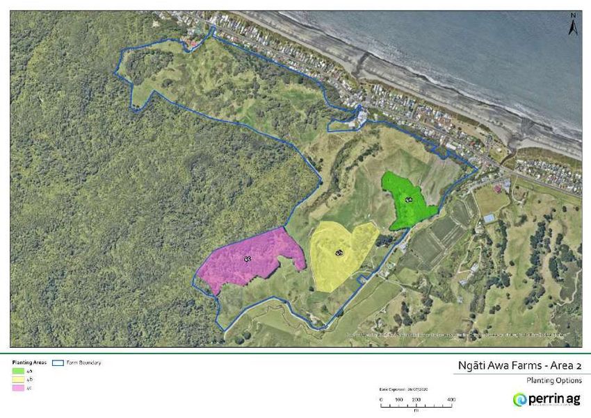
Introduction

The Integrated Farm Forestry Systems project is a multi-agency funded research and extension project,
led by Te Uru Rākau and co-funded by DairyNZ, the Waikato, Bay of Plenty and Horizons Regional
Councils, Living Water (DOC-Fonterra Partnership), Farmlands Co-operative and the Forest Growers
Levy Trust.

The project is being delivered by Perrin Ag and PF Olsen researchers in collaboration with farmer (dairy
and sheep & beef cattle) and industry groups. The project aims to address key issues associated with
increasing adoption of forestry within farm business and provide land owners, iwi and rural
professionals with the information they need to help land owners make well-informed forestry
enterprise decisions and increase their confidence in implementing forestry as a land-use option.

One of four key phases of the project is completing a diverse range of farm case studies (including iwi-
owned) to illustrate the impact of integration of various forestry options into existing pastoral farming
systems. This follows on from a series of farmer interviews that were completed in 2019 to gain an in-
depth insight into farm forestry practices, views and knowledge, and enablers and barriers to
integrating forestry into pastoral farming businesses (Dooley et al. 2020).

For this component, a range of complementary, integrated farming and forestry enterprises have been
evaluated with six Waikato/Bay of Plenty cases and four Rangitikei individual cases. Case studies cover
a variety of primary land uses (e.g. dairy, sheep & beef cattle, deer). Forestry options include Pinus
radiata, Douglas fir, mānuka and apiculture, PFSI (permanent forest sink initiative) forests for carbon
and biodiversity, short rotation exotic species (including high stocking rate special purpose radiata pine
for wood fibre supply) poplar space planting, and totara for timber. Case studies have been selected on
their potential to demonstrate enhanced business and environmental performance and to ensure
questions and knowledge gaps identified in Phase 1 of the project are explored. Once completed, the
case studies will be publicly available on-line and the findings disseminated amongst farmers and rural
professionals through a series of workshop and field days.

This case study, Ngāti Awa Farms Ltd, comprises a sheep and beef farm and two dairy units in the
Eastern Bay of Plenty region. It explores the potential of forestry to offset environmental externalities,
improve financial resilience and enhance productivity as well as meet Ngāti Awa’s financial, cultural and
social goals and visions.

                                                                                             Page 8 of 58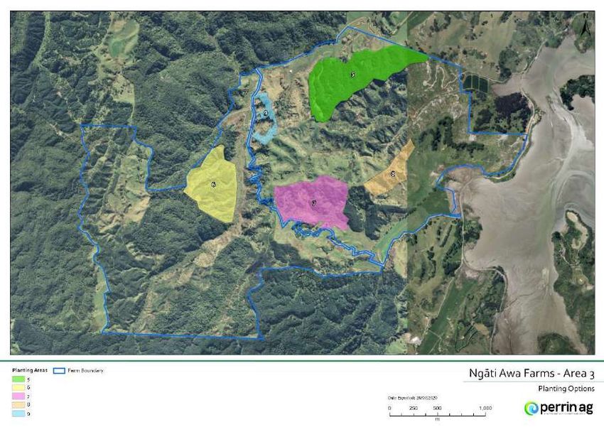
Methodology

For this phase of the project, a long list of case studies were identified through the researcher’s
professional networks and local project steering groups. The final case studies were confirmed after
evaluating the specific opportunities and challenges for each property against the key questions and
knowledge gaps identified in Phase 1, as well as ensuring appropriate regional and sector diversity.
Ngāti Awa Farms Ltd are one of the six Waikato/Bay of Plenty case studies analysed.

PROCESS
A property inspection was conducted at Ngāti Awa Farms Ltd on 18 June 2020, in which the landowners’
interest and preferences for integrating forestry into their existing business was explored, the
suitability of potential sites evaluated and information about the exiting farm and forestry activities was
captured. A standardised data capture method adapted from the DairyNZ Whole Farm Assessment
(Dairy NZ, 2016) process was used to ensure consistency in this process between case studies.

As part of this process the farm property was mapped and analysed in ARC GIS software. This was
done in order to identify the geo-physical differences of areas of the property identified for
afforestation. This is needed to both ascertain the impact on aggregated pasture production of
changing land use and identify forest growth potential.

Appropriate afforestation scenarios for integration to the existing land activities were developed in
association with Ngāti Awa Farms Ltd Species selection was guided by the overarching values of Te
Rūnanga o Ngāti Awa with more weighting placed on options that connected with these values. This
ensured that scenarios aligned with Ngāti Awa’s objectives and were of interest to them.

A financial investment analysis was considered beyond the scope of this case study with scenario’s
instead focussed on high level analysis in regard to the process and outcomes of the decision making
involved with afforestation. Potential implications in regard to ETS legislation and were also discussed
including testing some scenarios for the eligibility of ETS and funding schemes.

                                                                                              Page 9 of 58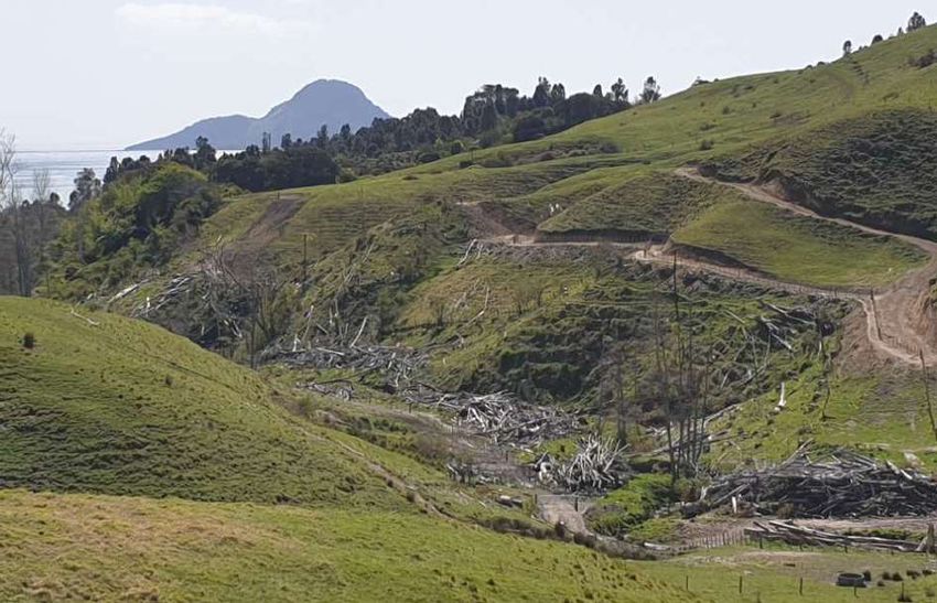
Section 1: Farm and business description

INTRODUCTION
Ngāti Awa is a tribe comprised of 22 hapū or sub tribes that trace their ancestry back to an eponymous
ancestor Awanuiārangi II, great grandson of Toroa the chief of the Mataatua waka that arrived at
Kakahoroa (original name for Whakatāne) from Hawaiki.

                                                    The Ngāti Awa rohe or territory extends from
                                                    Motiti Island and Maketu in the west to and
                                                    then inland following the Pongakawa stream to
                                                    Lake Rotoehu, the Rotoehu forest in the south
                                                    before following the Rangitāiki River to
                                                    Matahina, across the Whakatāne river
                                                    catchment and Tāneatua and then finally
                                                    following the Nukuhou River out to the Ohiwa
                                                    harbour.

Figure 1: Ngāti Awa Rohe (source Te Puni Kōkiri)

Following a 2005 settlement with the Crown to recognise historical breaches of the Treaty of Waitangi,
Te Rūnanga o Ngāti Awa was established as a post settlement governance entity to receive and
administer the settlement redress for and on behalf of Ngāti Awa.

Ngāti Awa Farms Ltd is the landholding company for Ngāti Awa Group Holdings Ltd, the asset owning
arm which manages the commercial and economic activities of Te Rūnanga o Ngāti Awa.

Ngāti Awa Farms Ltd own a 1,117 hectare drystock property that surrounds the Whakatāne Township
and are majority shareholders in a partnership with other hapū trusts in two dairy farms, Ngakauroa, a
204 hectare effective property on the Rangitāiki plain near Te Teko and Tumurau, a 340 hectare effective
property on Braemar Road, 2km north of Rotomā. Apart from farmland Ngāti Awa Group Holdings Ltd
also has financial interests in managed funds investment, forestry, commercial property, fisheries,
fishery quota and a tourism venture. These three farms are shown in Figure 2, Figure 3 and Figure 4 and
in order to distinguish them for the purposes of the case study they will be referred to as “Ngāti Awa
Drystock”, “Ngakauroa Dairy” and “Tumurau Dairy”.

                                                                                          Page 10 of 58
BUSINESS STRATEGY
The visions, goals and values of Ngāti Awa Farms Ltd encompass the overarching values of Te Rūnanga
o Ngāti Awa. The traditional Māori values of mana, mauri, whakapapa and tapu are central to Ngāti
Awa’s relationship with the natural environment; they are also interconnected with the following social
and cultural values:
Mauri ora (independence, resources and sustainability)
Toi ora (health and wellbeing)
Tūrangawaewae (culture and identity)
Tū Pakari (leadership and hapū unity)
These values form the decision making framework for business strategy, policy, vision and goals for
Ngāti Awa Farms Ltd In the context of Ngāti Awa Farms Ltd, apart from the economic benefits, the
farms are also a gateway for bringing people to the land and giving a sense of ownership and belonging
or tūrangawaewae.
VISION AND GOALS
Have successful and sustainable businesses that are not only economic but follow the values of
Ngāti Awa
Establish initiatives that create employment for Ngāti Awa people
High levels of health and education
Environmental stewardship providing Kaitiakitanga
Share innovative ideas with other iwi
Page 11 of 58Figure 2: Ngāti Awa drystock aerial map with property boundary (bold blue line)
Page 12 of 58Figure 3: Ngakauroa dairy unit aerial map with property boundary (bold blue line)
Figure 4: Tumurau dairy unit aerial map with property boundary (bold blue line)
Page 13 of 58FARM DESCRIPTION
Ngāti Awa Farms Ltd comprises of a drystock unit at Whakatāne, “Ngakauroa” a 600 cow dairy farm
near Te Teko and “Tumurau” a 900 cow dairy farm near Rotomā.
NGĀTI AWA DRYSTOCK FARM
A 1,117 hectare hill country breeding and finishing property surrounding the township of Whakatāne
and Ōhope beach settlement. The farm consists of 770 hectares effective pasture and is split into three
blocks separated by native bush or town boundary. A stock underpass and interconnecting laneways
through reserve land allow for the blocks to be managed as a single unit. The property winters 1,500
Romney ewes and replacements with the majority of the lambs finished on summer crop.
Approximately 235 Angus cows plus replacements are carried with all progeny retained as well as extra
young cattle purchased to total 540 trade cattle wintered.
Figure 5: Ngāti Awa drystock property (area 1 on farm map, figure 1) overlooking Kohi point and Ōhope
beach settlement in background
The topography includes numerous gully heads and stream catchments and, as a consequence,
topography ranges from steep faces, easy and rolling hill to small areas of flat valley floors.
The majority (84%) of the land is north facing, nearly half of the property is classified by Overseer slope
category as steep (>26°), 23% easy hill (16-25°) and the balance evenly split between flat (0-7°) to rolling
(8-15°) country.
The soils on the valley floors, which form the productive flat land on the property, can be categorised as
weathered fluvial recent soils (e.g. Galtymore_5a.2). These loam soils are characterised as being weakly
developed with generally good drainage unless waterlogged when pugging can become an issue.
Page 14 of 58Traditionally the property is summer dry and experiences a wet winter and spring. This is managed by
a flexible stock policy and managing wetter areas by grazing smaller stock classes (e.g. sheep and
young cattle).
The soils on the easy to rolling country are mainly pumice soils (Orang_2a.2) formed from Taupō and
Kaharoa ash, and are the most common soils on the property. The topsoil is typically sandy allowing
good rooting depth, drainage, has good water holding capacity, but has a moderate risk of erosion if
disturbed.
The steep areas contain steepland soils associated with allophanic pumice as well as tephric recent
soils which consist of volcanic material overlying sandstone rock (Ngātiawa_3a.1). This rock often lies
less than one metre below the weakly structured soil profile and impedes the rooting depth of plants
and trees. The loamy topsoil has good drainage and water holding capacity until the soil profile reaches
the impermeable rock. Once the soil becomes waterlogged there is a moderate risk of erosion.
Three streams flow through the property and out into the Whakatāne township and Ohiwa and Ōhope
harbours. These sensitive areas and any wetlands have been riparian fenced with further tributaries
identified for future fencing. Poplars have been planted on erodible land and there are existing pine
woodlots on small steep areas that are ready for harvest. Regenerating native bush has been fenced off
and an erodible gully head has been planted in mānuka.
Ngāti Awa Drystock is surrounded by the towns of Whakatāne and Ōhope, and parts of the farm are
opened up to community groups for events as well as year-round access provided to a network of
walking and cycling tracks. This public exposure reinforces the requirement for the property to do the
right thing environmentally, not only by Te Rūnanga o Ngāti Awa’s standards but also from the
perception of the general public.
NGAKAUROA DAIRY
A 204 hectare (202 hectares effective) spring calving dairy unit peak milking 670 cows. The farm is
stocked at 3 cows/ha and operates as a DairyNZ system 3, young stock are grazed off farm and
approximately 340 cows are grazed off over winter. Supplements include 16T of Palm kernel expeller
and 10 hectares of maize grown on farm as well as purchased hay and grass silage to fill autumn and
spring feed deficits. Production for the 2019-20 season was 230,412 kg MS (344 kg MS/cow or 1,141 kg
MS/ha).
The property is situated on the Rangitāiki plain and is flat in contour. Nearly all the effective area is
used as dairy platform with the exception of 1.5 km of stop bank along the Rangitāiki River used for
rough grazing. The majority of the property is a Perch Gley pumice soil (Awakeri_1a.1) characterised by
poor drainage, in part due to the flat contour. Fenced open drains transect the farm to provide
drainage.
Mean annual rainfall (Edgecumbe) is 1,527 mm. The property is also part irrigated, sourced from the
Rangitāiki river, from November to late March with a 68 hectare centre pivot and 25 hectares of lateral
irrigation.
TUMURAU DAIRY
A 340 hectare (315 hectares effective) spring calving, system 2, dairy farm peak milking 850 cows. The
farm is stocked at 2.7 cows/ha with all young stock grazed off and approximately 300 cows off the
platform over winter.
The contour is approximately 50% flat and 50% rolling pumice hillocks. In contrast to the well-drained
pumice hillocks (Taupō_37a.1) the flat land is poorly drained peatland over pumice parent material
(Pongokawa_2a.1). The flat land is a former wetland that was drained in the early 20th century, it
Page 15 of 58contains approximately 27.5 km of fenced drains and canals with 79 stock crossings. The drains and
canals either flow directly into the Tarawera River on the eastern boundary or into the Tumurau
wetland on the northern boundary. There are also numerous freshwater springs throughout the
property that are all fenced and make up 20.6 hectares of riparian area. The farm has 5 pivots on the
flats and some K line irrigation on the pumice hillocks; in total irrigation covers approximately 285
hectares.
Figure 6: Tumurau dairy unit
Figure 7: Tumurau dairy unit
Page 16 of 58CURRENT PLANTINGS
Current plantings mostly consist of radiata pine woodlots on Ngāti Awa drystock, ranging from smaller
areas of 3.5–10 hectares on steeper faces and rock features unsuitable for grazing to larger 30–45
hectare plantings on areas that traditionally had a lot of scrub reversion. All but one area of pine is first
rotation planting, either recently harvested or due for harvest in the next two years. The area of second
rotation forestry is planted in six year old pines, however, poor establishment has led to many open
areas that will require replanting.
Figure 8: Maraetotara Road pine plantation (area 4b) currently being harvested
Traditionally poplars have been planted along riparian areas and on erosion prone slopes, however
these trees are estimated to be 35 - 40 years old and are becoming a nuisance and a hazard falling
onto roads and fences. Recently a stand of poplars have been felled along the Wairere Stream
catchment with the area being progressively fenced off and identified for riparian planting.
An area of 27 hectares featuring an erodible gully head and patches of regenerating bush has been
planted in mānuka for honey production. Livestock were excluded from this six year old stand during
establishment, it is now at a height where rough grazing can be provided for livestock without
damaging plants.
The dairy units do not have as many plantings with most of the land utilised for productive grazing. On
Ngakauroa there are established plantings around the houses and cowshed for aesthetics. The
northern boundary of the farm contains a poplar shelterbelt and there are some barberry hedges
which were traditionally planted for aesthetics and stock exclusion. Existing plantings have been limited
to an extent by the centre pivot and lateral irrigation that cover a large area of the milking platform.
Page 17 of 58On Tumurau there are also established plantings around infrastructure such as the cowshed, staff
accommodation and some laneways. All of the natural springs and many of the drains have been
fenced off and planted in native species. These riparian plantings help reduce nutrient and sediment
runoff but also enhance the aesthetic value of the property. Tumurau also has centre pivot and lateral
K line irrigation covering much of the dairy platform limiting additional plantings. There are also 220
kVA pylon transmission lines running over part of the property which would limit the height and
proximity of tree plantations.
Figure 9: Existing riparian plantings, Tumurau dairy unit
SITE SELECTION CRITERIA
Te Rūnanga o Ngāti Awa hold the perspective that the primary function of the land under Ngāti Awa
Farms Ltd is farming and therefore, any areas retired from grazing must maintain or enhance
productivity and new and existing plantations must be able to fit around current farming operations.
The site selection criteria can be grouped into three broad categories:
i. Replanting existing woodlots with alternative species
ii. Environmentally sensitive areas
iii. Land that is identified as currently underutilised and may have more value in being planted in trees
REPLANTING EXISTING WOODLOTS WITH ALTERNATIVE SPECIES
On the drystock property smaller pine woodlots were planted in the 1980’s and 1990’s on largely
ungrazeable areas that contained steep terrain, rocky outcrops, or blocks with tracts of regenerating
bush. Some of these areas contain archaeological sites which would restrict replanting as growth and
future harvest events may cause damage.
Ngāti Awa Group Holdings has a forestry arm Ngāti Awa Forestry Ltd which has significant interest in
8,400 hectares of pine plantations. Therefore, the iwi does not see pine plantation on its farmland as a
core interest and would rather look to plant alternative species. Consideration is given to species that
not only have a timber value but may also provide an alternative income stream (e.g. carbon, floral
honey), create biodiversity and/or have cultural significance.
Poplars, traditionally grown on the drystock farm for erosion control or in riparian areas, have now
grown too large for their purpose, posing a hazard with trees and branches falling on roads and
infrastructure. Ngāti Awa has identified theses areas of poplars for removal and replanting with an
alternative species or modern variety of poplar that is fit for purpose.
Page 18 of 58ENVIRONMENTALLY SENSITIVE AREAS
Ngāti Awa seeks to reduce the environmental footprint of their farming operations and farm in a
sustainable manner. Options of retiring land that enhances their properties from an environmental,
financial, aesthetic and cultural viewpoint are actively considered.
Ngāti Awa drystock contains the catchment of three important streams that flow into the Whakatāne,
Ōhope and the Ohiwa harbour. These streams (Wairere, Maraetotara, Wainuitewhara) are being
progressively fenced off from livestock and riparian planted.
Some erosion prone areas have been retired and planted in mānuka and there is further scope for
more plantings provided it doesn’t negatively impact on farming operations.
On the dairy units the risk of sediment and microbial pathogen runoff from farm races into adjacent
drains is an issue – as highlighted in recent farm environment plans commissioned for each property.
This is exacerbated by some stock races having insufficient setbacks from drains. There is an
opportunity to reduce runoff with the right plantings between the races and drains, acting as a filter.
UNDERUTILISED LAND
Any land that is underutilised in its current form of livestock farming would be considered for planting.
On Ngāti Awa drystock this may include steeper terrain that cannot be grazed effectively or areas
where there is already significant scrub reversion and the costs from ongoing weed control outweigh
the benefits of keeping that land in pasture. On the dairy property this may include steeper, drier areas
of the property that contribute little to annual pasture production (Tumurau) or in the case of
Ngakauroa a long narrow area of stop bank currently used for occasional grazing of drystock.
Page 19 of 58OVERVIEW OF SITES
The sites selected for new plantings for this report include woodlots near harvest or recently harvested
areas with regenerating native vegetation. The exception being the existing stand of plantation mānuka
which was further utilised as a cover crop for native regeneration.
Table 1 in the appendices gives an overview of the chosen sites including details such as area, slope,
aspect, previous cover, planting suggestions and subsequent eligibility for funding grants and ETS.
Figure 10: Ngāti Awa drystock farm showing selected planting areas 1-3
Page 20 of 58The local climate is characterised as temperate due to the proximity to the coast. Average long-term
annual rainfall for Whakatāne and Edgecumbe is 1,189 and 1,376 mm, respectively. Mean annual
average temperature is 14 degrees, with Whakatāne experiencing some of the highest sunshine hours
nationally. Frosts are site specific to sheltered areas generally inland and winds are predominately of a
Northwest – Southwest flow.
Overall, the sites are climatically suited to growing a wide range of species options with the main
physical limitations being topographic (slope and aspect). The moderate risk of high rainfall events
could pose an erosion risk to seedlings planted on sites with disturbed topsoil (e.g. cutover pine).
Figure 11: Ngāti Awa drystock farm showing selected planting sites 4a – 4c
Depending on the slope and aspect there will be microclimates which favour a particular species option
over another. One example are the natural amphitheatre areas on Maraetotara Road recently
harvested for pines (areas 4a, 4b, shown in Figure 11.) This area due to being sheltered and southerly
facing, is often 3 degrees cooler than Ōhope beach which is only 600 m away.
The aspect of the sites is mainly to the south with the exception of the two larger pine blocks which are
to the north and east. Topography of the sites consists of mainly steep faces, however, some areas can
be categorised as gully heads while the riverbank area on the Ngakauroa Dairy unit is a gentle, westerly
facing slope (area 10, Figure 13). Tumurau Dairy unit has some rolling to steep north facing banks and
sidling’s identified as possible replanting areas (areas 11a, b and c, Figure 14).
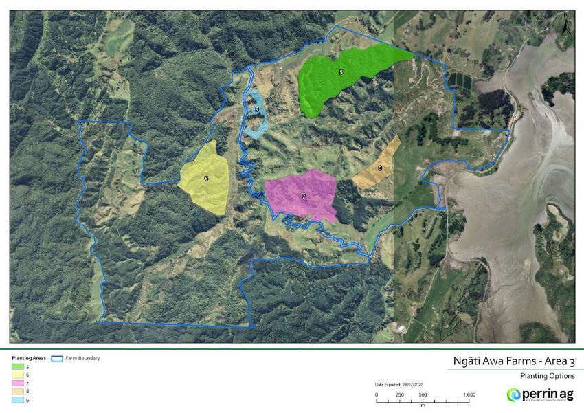
Page 21 of 58Figure 12: Ngāti Awa drystock farm showing selected planting sites 5-9
Page 22 of 58Figure 13: Ngakauroa dairy planting site 10
Figure 14: Tumurau dairy planting sites 11a -11c
Page 23 of 58Section 2: Forestry options
SPECIES SELECTION
Species options were selected based on the concept “right tree, right place, right purpose” and Ngāti
Awa’s desire to identify suitable alternative options, rather than Pinus radiata, for planting new and
existing areas. Decisions on species selection are guided by the overarching values of Te Rūnanga o
Ngāti Awa – meaning more weighting is placed on species options that interconnect with these values
as well as the economic returns, social, cultural and environmental co-benefits. Examples of how a
particular species may provide benefits that resonate with Te Rūnanga o Ngāti Awa include:
Providing ongoing employment for hapū, e.g. silviculture and pest control
Timber can be used for carving or species may have traditional medicinal properties (i.e. rongoā)
Enhancing the landscape
Specific cultural or spiritual significance to Ngāti Awa
THE SPECIES SELECTED
Tree species selected for timber were totara (Podocarpus totara) and coast redwood (Sequoia
sempervirens). Radiata pine (Pinus radiata) was not selected as an option, however, was discussed in
terms of a comparison species for scenario analysis. Mānuka (Leptospermum scoparium) and kawakawa
(Piper exelsum) were chosen as cover crops to colonise the bare land prior to planting timber species.
Pōhutukawa (Metrosideros excels) and kahikatea (Dacrycarpus dacrydioides) were chosen as alternative
timber species. Modern cultivars of poplar (Populus genus) were selected for erosion control and a
mixture of native species for riparian planting or landscape enhancement.
TOTARA
Totara was selected as it is a native prevalent in the area, able to grow in a wide range of sites, suitable
for timber production and carbon sequestration. Traditionally, totara was prized by Māori as its length,
durability and ability to be easily worked made it valued for carvings (whakairo), instrument making,
canoes and waka building amongst other uses. European settlers used totara timber for a wide variety
of uses including bridges, fence posts, wharf piles and buildings, the heartwood was recognised for its
durability in outdoor applications whilst the timber’s natural resistance to borer made it popular for
structural use in buildings.
Currently totara timber is sourced as ‘old wood’ from recycled timber for use in decorative interior
joinery, or as ‘farm totara’ from regenerating totara or plantations on private land on a small
commercial scale. The Northland Totara Industry Pilot Project (TIPP) is a two year collaborative
programme that began in 2019 and is funded by Tanes Tree Trust, Scion, Northland Inc., Te Taitokerau
Maori Forestry Inc. and Te Uru Rākau. It has started sustainably milling farm totara in larger
commercial quantities and supplying the timber to the Auckland regional market in order to assess and
test the entire supply chain with the aim of developing a domestic totara timber industry. A report by
Satchell (2016) highlighted there are clear markets for higher grade heartwood and potential markets
for sapwood in structural applications which would open up once the known qualities of totara were
officially tested against the durability and structural requirements of the New Zealand Building Code.
COAST REDWOOD
Coast redwood has an ability to grow in a range of sites and its timber production and carbon
sequestration potential is greater than that of native species. There is a strong traditional demand for
redwood timber in California where the species originates from. As a result of dwindling timber supply
in their homeland some American foresters, such as the New Zealand Redwood Company, have sought
Page 24 of 58to establish forests in New Zealand. A potential export market exists for good quality heartwood where
redwood is used for a decorative timber due to its dark colour and natural durability for outdoor
decking and cladding.
PŌHUTUKAWA AND KAHIKATEA
Pōhutukawa (Metrosideros excels) and kahikatea (Dacrycarpus dacrydioides) were chosen as further
options but timber production is a secondary attribute with their main purpose being biodiversity and
landscape enhancement. Pōhutukawa is already prevalent in the costal landscape, and grows well in
rocky escarpments. Kahikatea was chosen for its ability to grow in riparian areas and at the base of
gullies for erosion control.
MĀNUKA AND KAWAKAWA
A ‘pioneer’ or cover crop such as mānuka or kawakawa was chosen to be planted with the native timber
species. These would colonise bare land, complement any regenerating native regrowth and provide
shelter as the timber species grew. Another advantage is the cover crops allow for more rapid carbon
sequestration until the slower growing timber species become established. In that time there is
opportunity to create income from mānuka honey as well as utilising kawakawa commercially for its
medicinal properties.
Ngāti Awa has a pure mānuka stand with hives placed on it by a third party. Annual mānuka honey
yields can range from 20 – 40 kg honey/ha with a range of profit share contracts available to land
owners. Income from mānuka honey would complement carbon revenue from the mānuka cover crop
until seedling tree species eventually become established and form the forest canopy after 15 – 20
years.
Mānuka was also chosen as a single species plantation along the stop bank area of Ngakauroa Dairy
unit. The gentle sloping, long narrow area would be ideal for mechanically harvesting mānuka foliage
for oil production.
POPLAR
Modern poplar cultivars were chosen to replace the ageing poplar stand, smaller modern varieties such
as “Kawa”, “Toa” and “Tasman” have the following benefits:
More upright growth characteristics and smaller crown compared to older varieties.
Smaller mature height of 20-25 metres and improved disease tolerance.
Able to be planted in a sleeve with little impact on area taken out of production.
At 40 stems/ha there is potential to reach 30% canopy at 12 years for carbon income (Eyles, 2010).
However, shading effect will reduce pasture production by 25% (Wall, 2006).
Potential timber value providing form pruning and thinning of trees is carried out.
Certain areas would suit landscape enhancement planting, where aesthetic or cultural values would
outweigh economic returns from timber production.
The dairy units where tree height may become a problem – i.e. shading and irrigation.
Mixture of species for aesthetics, trees that enable a five metre canopy height (for ETS eligibility),
flowering trees to attract bird life/honey potential and endemic species.
E.g. kōwhai, cabbage trees, pōhutukawa, flaxes, lemonwood, lancewood etc.
Alternatively, species could be planted specifically for rongoā purposes or mahinga kai.
Page 25 of 58Section 3: Scenario analysis
There were 11 potential planting sites identified across the three farms and as a result it was
considered beyond the scope of this report to examine each individual site in detail.
Instead, a selection of sites were chosen that were able to be grouped together into three different
scenarios. These scenarios explored replanting radiata pine stands in alternative species, planting
underutilised land in mānuka for oil production and identifying and planting riparian areas to be 1BT
and ETS eligible.
The purpose of these scenarios is to examine in more detail:
Eligibility for grants – the process, amount, timing, what is required.
Carbon sequestration potential depending on forest species, forest area and methodology used to
measure carbon stock.
Possible liabilities that may arise from the forestry option in relation to ETS legislation.
Another factor when choosing the scenario options was the probability of other farmers also facing the
same or similar scenarios on their own property, this would give the report relevance to the wider
farming sector.
Page 26 of 58AN OVERVIEW OF FORESTRY IN THE EMISSIONS TRADING SCHEME (ETS)
The Emissions trading scheme is a way for New Zealand to meet its international obligations
surrounding climate change. Essentially it puts a price on greenhouse gases to provide an incentive for
emitters to reduce emissions and for landowners to establish and manage forests in such a way that
more carbon storage is created.
The unit of trade within the ETS is known as a ‘New Zealand Unit’ or NZU, one unit represents one tonne
of carbon dioxide. The Crown issues NZU’s for increases in carbon stock for eligible forests that
participate in the ETS, these may be held, bought or sold within NZ.
NZU’s are held in the New Zealand Emission Unit Register (NZEUR), ETS participants must have a holding
account in the NZEUR for unit transfers.
Forest owners can participate in the ETS in two ways – either by voluntarily registering their post 1989
forests in the ETS or becoming mandatory participants if they are owners of non-exempt pre 1990 forest
that becomes deforested.
Definition of forest land
Forest land is defined as an area at least a hectare in size, with at least 30% of that hectare covered in
forest species, capable of reaching at least 5 metres in height at maturity in the location they are
growing. The forest species must also be capable of achieving a canopy closure of at least 30% at
maturity and have an average width of at least 30 metres. “Forest species” is defined as a tree capable of
reaching 5 metres in height but excludes trees grown primarily for fruit and nut production.
Pre 1990 forest
Pre 1990 forest land:
Was forest land on 31 December 1989,
Remained as forest land on 31 December 2007,
And contained predominately exotic forest species on 31 December 2007
Land that was indigenous forest land (e.g. native bush) on 31 December 1989 and remained so on 31
December 2007 is not pre 1990 forest.
In recognition of the impact of ETS regulations on land use flexibility, owners of pre 1990 forest land
were given up to November 2011 the option to apply one off allocation of 60 NZU’s per hectare.
Pre 1990 forest owners can harvest and replant their land without any liability – that is they are not
obliged to pay or surrender NZU’s if their carbon stock decreases (e.g. due to harvesting) regardless of
whether they received the one off allocation of NZU’s or not.
They are liable however, (with some exceptions) if the land is converted to another land use other than
forestry, or replanting or regeneration has not occurred within specified timeframes – by definition
where “deforestation” occurs. In this situation the landowner is liable to surrender sufficient NZU’s to the
Crown based on the pre 1990 deforestation lookup tables.
The post-harvest area to be replanted (classified as “temporarily unstocked” forest land) must meet the
following replanting and regeneration criteria in order not to be deemed “deforested”
Four years after clearing must be replanted with 500 stems per hectare of forest species or 100
stems per hectare of willows or poplars consistent with managing soil erosion.
Alternatively regenerated with at least 500 stems per hectare of exotic or native forest species in
such a manner that 10 years after clearing the hectare is likely to be forest land.
Page 27 of 58 10 years after clearing the hectare must be predominately exotic forest species growing and
have a crown cover of 30% from trees that have reached 5 metres in height. Or be
predominately indigenous forest species growing and the hectare is forest land.
20 years after clearing the hectare must be predominately indigenous forest species with a tree
crown cover of at least 30% from trees that have reached 5 metres height.
Post 1989 forest
Was not forest land on 31 December 1989
Was forest land on 31 December 1989, but was deforested between 1 January 1990 and 31
December 2007, or
Was pre-1990 forest land that was deforested on or after 1 January 2008, and any ETS liability.
Participants must file an emissions return once in every mandatory emissions return period (MERP) to
account for changes in their forest's carbon stock. A voluntary return can be made once a year in order
to claim NZU’s as a result of an increase in a forests carbon stock.
However, participants must also repay units if a forests carbon stock decreases (e.g. fire, windthrow) and
even if the decrease in only temporary (e.g. harvesting).
Participants are also required to notify the government if some or all of the registered post-1989 forest
land is transferred to another person or entity (e.g. forest is sold).
If the land is withdrawn from the ETS then the total number of units received for the forest since ETS
registration must be surrendered (regardless of who received the units).
*Note: Carbon averaging accounting is a new method of measuring carbon stock of forests participating in the
ETS, it was introduced as part of amendments to the Climate Change Response Act and will become mandatory
for all new forests by 2023. This new method is discussed with more detail on pages 29 and 38.
MPI Default Carbon tables and Field Measurement Approach for calculating forest carbon storage
Under current ETS rules, participants are required to use one of two methods to measure forest carbon
stocks depending on the size of their forest. A forest is defined as a Carbon Accounting Area (CAA) from
which carbon stocks are measured and can be made up of either a single land parcel or multiple land
parcels greater than one hectare in size.
For forests less than 100 hectares in size participants are required to use default MPI carbon look-up
tables to calculate carbon stocks.
Forests greater than 100 hectares or greater in size are required to use participant specific carbon tables
generated from the “Field Measurement Approach” (FMA). The FMA is a site specific measurement based
method for determining forest carbon stock change based on collecting data from individual sample
plots within a participant’s forest. The forest inventory and growth modelling techniques used are
recognised professionally within the NZ forestry sector.
MPI determines the number of sub plots required to collect information based on the forest size, for
example 30 sample plots for 100 hectares and 200 sample plots for 10,000 hectares or more.
Page 28 of 58Current accounting method for measuring carbon change and proposed carbon average
accounting method
The current carbon stock change accounting approach requires ETS participants to account for any loss
of carbon in their forests, even if that loss is temporary. This means surrendering NZU’s earned during
forest growth at harvest and being liable for any carbon loss associated with adverse events (e.g. fire,
windthrow).
Carbon averaging accounting is a new method of measuring carbon stock of forests participating in the
ETS, it was introduced as part of amendments to the Climate Change Response Act and will become
mandatory for all new forests by 2023.
Currently new forests joining the ETS have the option of either scheme, forests registered between 1
January 2019 and 31 December 2022 have the option of transitioning to average accounting.
With carbon averaging ETS participants with first rotation post 1989 forests will be able to earn NZU’s up
to a forests “average” age. This average age is based on the long term carbon storage of a forest over
several rotations of growth and harvest at an assumed commercial harvest age typical to their forest
type e.g. (28 years for Pinus radiata). They will not be liable to repay credits for the temporary carbon
loss through harvesting or adverse events such as fire or windthrow.
For a comprehensive overview of forestry in the ETS visit the Te Uru Rākau website:
https://www.mpi.govt.nz/growing-and-harvesting/forestry/forestry-in-the-emissions-trading-scheme/
Page 29 of 58SCENARIO 1: REPLANTING RADIATA PINE STANDS WITH NATIVE OR EXOTIC SPECIES
The following scenario uses the option of replanting pine forests in native totara using a cover crop of
mānuka or kawakawa, or replanting in coast redwood with no cover crop.
Various radiata pine stands on Ngāti Awa Drystock were identified as sites for replanting and used to
examine the following:
Eligibility for funding for replanting pine forests in native species
ETS liability associated with replanting forests depending on whether they were classified as a “pre
1990 forest” or “post 1989 forest” and the potential to earn carbon from the subsequent forest
rotation.
A comparison of using the current MPI default carbon look-up tables and FMA method for
measuring carbon accumulation in native and exotic softwood forests.
Registering a post 1989 forest in the ETS for its second or subsequent rotation.
A comparison of the current “stock change” accounting method for measuring carbon and the soon
to be introduced “carbon average accounting” method available for new ETS participants.
ELIGIBILITY FOR FUNDING WITH THE SAME CRITERIA AS 1BT
As discussed in the site selection criteria, Ngāti Awa drystock contains many areas of first rotation pine
that either have been harvested or are ready to harvest. These areas have been identified to replant in
an alternative species.
In order to be eligible for the same criteria as 1BT funding, land must not be ‘forest land’ at the time of
application nor must it have been forest land for 5 years prior. As the sites in this scenario have been,
or are currently planted in, first rotation pine they come under the definition of ‘forest land’ and are not
eligible under the same criteria as 1BT funding.
There are two sites however, that may be an exception to the general ruling around 1BT funding; these
are the 16.1 hectare Maraetotara Road natural amphitheatre areas (4a and 4b), comprising of two
recently harvested pine stands covering archaeological sites.
MPI does state that under “exceptional circumstances” they will consider funding native and reversion
projects on land that does not meet the previously mentioned criteria (Te Uru Rākau, MPI website
2020). Under this notion it may be beneficial for Ngāti Awa to investigate whether replanting around
archaeological sites previously in pine with more suitable native species would qualify as ‘exceptional
circumstances’.
PRE 1990 FOREST
Ngāti Awa have two stands of pre 1990 pine forest that have been selected for replanting.
Pre 1990 forests have no ETS liability for harvesting and replanting providing the forest is replanted
within a pre-specified timeframe or sufficient regeneration of forest species occurs (see notes in “an
overview of forestry in the ETS” section).
If replanting or regeneration does not happen then “deforestation“ is considered to have occurred.
There is an allowance of up to two hectares of pre 1990 forest deforestation in a five year period,
beyond which NZU’s would have to be surrendered to the Crown to match the loss of area to
deforestation.
The first stand is a 3.4 hectare area (Figure 10, area 1) harvested two years ago and is now regenerating
in native species. This area could be left to regenerate if the vegetation is deemed “forest land” in 10
years and by 20 years have tree crown cover of 30% and a height of at least 5 metres.
Page 30 of 58You can also read