International Cartographic Conference - 15th-20th July 2019 Program - ICC 2019 Tokyo
←
→
Page content transcription
If your browser does not render page correctly, please read the page content below

29th

International
Cartographic
Conference
15th-20th July 2019
                      JHOD

         Program
Table of Contents

                                                                      ©JHOD

                Local Organizing Committee…………………………………… 2
                Sponsor List…………………………………………………………… 3
                Conference Themes……………………………………………… 4
                Keynote Presentations…………………………………………… 5
                Venue…………………………………………………………………… 7
                Floor Plan……………………………………………………………… 8
                ICC2019 Joint Activities……………………………………… 11
                International Cartographic Exhibition…………………… 12
                Barbara Petchenik Children’s World Map
                Drawing Competition…………………………………………… 12
                International Technical-Commercial Exhibition……… 13
                Technical Tour…………………………………………………… 14
                Social Program…………………………………………………… 15
                Post Congress Tour…………………………………………… 16
                Program at a Glance…………………………………………… 17
                Scientific Program at a Glance……………………………… 18
                Program……………………………………………………………… 20
                Commission Business Meeting…………………………… 59
International Cartographic Conference

Local Organizing Committee
President
Takashi Morita (Hosei University)

Secretary general
Yoshiki Wakabayashi (Tokyo Metropolitan University)

Vice-secretary general
Masatoshi Arikawa (Akita University)

Chair of the Treasury Committee
Yohta Kumaki (Senshu University)

Vice-Chair of the Treasury Committee
Yasuhiro Ochiai (Nihon University)

Chair of the Program Scheduling
Jun Sato (Geospatial Information Authority of Japan)

Vice-Chair of the Program Scheduling
Hideyuki Fujita (The University of Electro-Communications)

Chair of the Public Relations Committee
Kaori Ito (Tokyo University of Science)

Chair of theVenue & Exhibitions
Atsushi Suzuki (Rissho University)

Chair of the Events & Excursions
Hiroshi Ota (Keio Futsubu School)

Chair of the Commission Meeting
Mamoru Koarai (Ibaraki University)

Member
Yasushi Asami (The University of Tokyo)		                    Toru Ishikawa (The University of Tokyo)
Teruko Usui (Nara University)			                             Atsuyuki Okabe (Aoyama Gakuin University)
Kohei Okamoto (Nagoya University)			                         Takashi Oguchi (The University of Tokyo)
Ryosuke Shibasaki (The University of Tokyo)		                Shigeko Haruyama (Mie University)
Yukio Himiyama (Hokkaido University of Education)            Yuji Murayama (Tsukuba University)
Keiji Yano (Ritsumeikan University)

Steering committee members and collaborators
Hiroyuki Endo (Next Publishing Inc.)			                      Yoichi Eto (Ministry of Land, Infrastructure, Transport and Tourism)
Taichi Furuhashi (Aoyama Gakuin University)		                Seia Hisai (Japan Map Center)
Toyoaki Kawai (Shinagawa Joshi Gakuin)		                     Taketo Kobayashi (Chiba Prefectural Chiba Senior High School)
Masami Komiya (Teikoku-Shoin Co., Ltd.)		                    Hiroshi Masaharu (Toyo University)
Madoka Nakajima (Kokusai Kogyo Co. Ltd.)		                   Takayuki Nakano (Geospatial Information Authority of Japan)
Yuichiro Nishimura (Nara Women's University)		               Takuya Nojiri (Geospatial Information Authority of Japan)
Morishige Ota (Kokusai Kogyo Co. Ltd.)		                     Tadamitsu Saito (Japan Cartographers Association)
Toshikazu Seto (The University of Tokyo)		                   Nonoko Tsukada (Tokyo Map Research Inc.)
Masaharu Tsuzawa (Association of Precise Survey and Applied Technology)
Taro Ubukawa (Geospatial Information Authority of Japan)     Hidetoshi Ueda (Japan Hydrographic Association)
Hiroshi Une (Japan Cartographers Association)		              Katsuhiko Urabe (Nihon University)

                                                              2
International Cartographic Conference

Sponsor List                                    (in alphabetival order)

                                                         GLOBAL

                                                     HEMISPHERE

                                                    CONTINENTAL

                      INTERNATIONAL TECHNICAL-COMMERCIAL EXHIBITION
● AERO     ASAHI CORPORATION                                       ● Laboratory    for Cartographic Literacy
● ASAHI    ETIC CO., LTD.                                          ● Ministory   of Internal Affairs and Communication
● Center   for Spatial Information Science,                        ● ORBITAL      NET INC.
  the University of Tokyo & Tokyo Digital Archives Project         ● Pacific   Spatial Solutions, Inc. / Avenza Systems Inc.
● CHINA     MAP CULTURAL AND CREATIVE INDUSTRY                     ● PASCO      CORPORATION
  ALLIANCE                                                         ● Remote     Sensing Technology Center of Japan
● EAST    VIEW GEOSPATIAL                                          ● SuperMap      Japan CO., Ltd.
● Esri                                                             ● TEIKOKU      - SHOIN
● Esri   Japan Corporation                                         ● The   Korean Cartographic Association
● Hokkaido-Chizu      Co., Ltd.                                    ● TOKYO      GEOGRAPHICAL SOCIETY
● KIMOTO     CO., LTD.

                             ADVERTISEMENT IN CONFERENCE PRODUCTS
● Georepublic    Japan                                             ● Nippon    Sogo Systems, Inc.
● MIERUNE      Inc.                                                ● Taylor   & Francis Asia Pacific

                                                   SUPPORTED BY
● The    Association of Japanese Geographers                       ● Japan     Cartographers Association
● GIS    Association of Japan                                      ● Japan     Coast Guard
● Geospatial   Information Authority of Japan                      ● Japan     Organization of Geographical Sciences
● The    Human Geographical Society of Japan                       ● Tokyo    Geographical Society
● Japan    Aerospace Exploration Agency                            ● Tokyo    Metropolitan Government

                                                               3
International Cartographic Conference

Conference Themes
                                                                         Venne
                                                                             Miraikan
                                                                             Plaza Heisei
                                                                             Integrated/Cancelled

T01    Art and Cartography
T02    Atlases
T03    Cartographic Heritage into the Digital
T04    Cartography and Children
T05    Cartography in Early Warning and Crisis Management
T06    Cognitive Issues in Geographic Information Visualization
T07    Education and Training
T08    Generalisation and Multiple Representation
T09    Geospatial Analysis and Modeling
T10    GI for Sustainability
T11    History of Cartography
T12    Location Based Services
T13    Map Design
T14    Map Production and Geoinformation Management
T15    Map Projections
T16    Maps and Graphics for Blind and Partially Sighted People
T17    Maps and the Internet
T18    Mountain Cartography
T19    Open Source Geospatial Technologies
T20    Planetary Cartography
T21    SDI and Standards
T22    Sensor-driven Mapping
T23    Topographic Mapping
T24    Toponymy
T25    Ubiquitous Mapping, Spatial DB and IoT-Based Systems
T26    Use, User and Usability Issues
T27    Visual Analytics
T28    Marine Cartography
T29    Digital Humanities and GIS
T30    GIS, Remote Sensing and Cartographic Theory, Methodology and Applications
T31    Visualization and Analysis of Geographical Process
T32    Mapping Cities
T33    Design and visual variables: Rethinking Jacques Bertin
T34    Geo for All: Open source GIS education
T35    Crowdsourced Geospatial Information
T36    Transition to Modern and Contemporary Mappings
T37    Maps for SDGs
T38    Mapping the Environment
T39    Theoretical Cartography
T40    AI, Robotics, Autonomous Cars and Mapping
T41    Maps and Games
T42    Big Data and Data Science
T43    Others
Asia   Asia GIS

                                               4
International Cartographic Conference

Keynote Presentations
                             Venkatesh Raghavan
                             Professor of Geoinformatics, Osaka City University, Japan
                             ■ TUE 16 JUL

                             ■ 13:30-14:30

                             ■ International Conference Hall, Plaza Heisei

BIOGRAPHY
Prof. Venkatesh Raghavan is an alumnus of the Department of Geology, Pune University and obtained his Doctor of Science in Geological Remote Sensing from Osaka
City University Japan in 1994. He is presently based in Japan as Professor of Geoinformatics at the Graduate School of Engineering, Osaka City University. His research
interest includes geospatial Web Services, sensor network, Geo-Crowd Sourcing and remote sensing for change detection. Prof. Venkatesh Raghavan was one of the
founders of the Free and Open Source Software for Geoinformatics (FOSS4G) global initiative in 2004. He has been involved in OSGeo Foundation (www.osgeo.org) since
its inception in 2006. He was on the first OSGeo Board and was re-elected to again in 2015 and served as the President of the Foundation during 2016-2017. He is on the
Advisory Board of the Geo4All initiative (www.geo4all.org). He plays active role in promoting FOSS4G in Asia.
Prof. Raghavan is currently Co-Editor-in-Chief of Spatial Information Research and is on the Editorial Board of International Journal of Geoinformatics and Applied
Geomatics journals. He is the founder of ZOO WPS Platform Project which offers a comprehensive framework for deploying Geospatial-Software as a Service (Geo-SaaS).
He is a team leader and member in several Geoinformatics projects and has vast experience in conducting national and international training programs and development
of learning materials for RS/GIS using FOSS4G. He is actively involved in promoting Free and Open Source Software Solutions for Geoinformatics (FOSS4G) worldwide
including organizing global, regional and national FOSS4G events.
He was awarded the Mining & Material Processing Institute of Japan Young Scientist Award in 1995. He has taken up visiting professor assignments at prestigious
universities such as the Asian Institute of Technology, Bangkok and China University of Mining and Technology, Beijing. Prof. Venkatesh Raghavan was recipient of the
2012 Sol Katz Award for his contribution to the Open Geospatial Community and remains to be only Asian to receive this honour till date.

Beyond the Jargon: FOSS4G, OSGeo, Geo4All and ME4E
Geo-enabled Information and Communication Technology (Geo-ICT) is the mainstay of several international and national initiatives. Geo-ICT research contributes to the
development of various location-aware services using Global Positioning Systems (GPS), the Internet of Things (IoT), Sensor Networks (weather, environment, water/air
pollution etc), and Remote Sensing (satellites, UAV’s). Applied Geoinformatics, using tools such as Geographic Information System (GIS) and Remote Sensing, supports an
increasingly wide range of disciplines that include the arts, humanities, social/natural sciences and engineering.
 Open Source Software, Open Hardware, Open Data and Open Standards constitute the four vital pillars supporting the implementation and deployment of interoperable
and scalable Geo-ICT solutions for a variety of applications areas. A robust and customizable platform to facilitate Geospatial-Software as a Service (Geo-SaaS) forms
the backbone of several citizen centric initiatives. Prudent and effective use of geospatial technologies requires the fostering of a highly skilled workforce for developing,
maintaining Geo-ICT solutions for societal needsThe FOSS4G (Free and Open Source Solutions for Geoinformatics) initiative that began in 2004, has gained widespread
acceptance the world over the 15 years. Since 2006, the Open Source Geospatial Foundation (OSGeo) has been spearheading the collaborative development of open
source geospatial software and promote its widespread use. Active OSGeo Chapters have also been established worldwide to cater to specific local needs. As a part
of the educational outreach and skill development, the OSGeo Foundation along with partner organizations such as the International Cartographic Association and the
International Society for Photogrammetry and Remote Sensing has also established the Geo4All international network of universities and research institutions offering high-
level training and sharing of knowledge and experiences to build a strong and vibrant geospatial workforce.
Further, in recent years, a wealth of geospatial Open Data has become available through international and national agencies but also through participatory data production
initiatives such as the Open Street Map. Due to the proliferation of GPS-enabled devices, Crowd Sourcing and Volunteered Geographic Information has also facilitated
easy gathering and value addition of open geospatial data. The past decade has also seen the maturity of international standards for geospatial data exchanges and
interoperability though the initiatives of the Open Geospatial Consortium (OGC) and ISO.
This talk aims at demystifying the acronyms FOSS4G, OSGeo and Geo4all through temporal focus on the past, present and future. The speaker plans to narrate some
anecdotes and personal experiences as experiential traveller the FOSS4G world. A gist of some new initiatives being undertaken and priorities for coming years will be
outlined. Lastly, opportunities for joint industry-academia-government initiatives for collaborative innovation in mapping and cartography will be discussed. Some examples
of leveraging the Free & Open geospatial ecosystem for deploying a participatory mapping framework to bring about positive social change will also be presented.

                             Steve Coast
                             Vice president, TomTom
                             ■ WED 17 JUL

                             ■ 13:30-14:30

                             ■ International Conference Hall, Plaza Heisei

BIOGRAPHY
Coast interned at Wolfram Research before studying computing science at University College London (UCL).
In July 2004, he founded the OpenStreetMap project (OSM).
Coast set up Z.X.V. Ltd. with Nick Black, Tom Carden and Ben Gimpert as a technology consultancy in 2005. In 2008 this became CloudMade after investment by
Nikolaj Nyholm and Sunstone Capital (company's website claims it was established in 2007). He resigned from CloudMade in October 2010, although he remained a
shareholder.[citation needed]
On 23 November 2010, Coast announced that he had accepted a position as Principal Architect at Microsoft's Bing Mobile.
On 3 September 2013, Coast wrote on his blog that he had started to work for TeleNav, taking care of OSM development for the company's Scout navigator.
In March 2014, Coast became an advisor to Auth0, an identity-as-a-service provider.
In November 2015, Coast published ""The Book of OSM"". The book contains 15 interviews conducted by Coast with various users who had participated in the project
since its beginning.
In January 2016, he stepped down from full-time work at TeleNav and started his work as a board advisor in Navmii. In March 2016 he started working as Chief
Evangelist for what3words. In May 2016 he became an advisor in MapJam. In fall 2017, he joined DigitalGlobe. In spring 2019 he joined TomTom as a vice president
in the Maps department.

The Past, Present, and Future of OpenStreetMap
Steve will be presenting on the past, present and future of OpenStreetMap – discussing how to edit, licensing, community and more. Steve will also discuss his book,
“The Book of OSM”, containing interviews with 15 early adopters of OSM to capture the early growth and feeling of the project.

                                                                                      5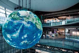
International Cartographic Conference

Keynote Presentations
Ayako Kagawa
Geographic Information Officer, Chief Cartographic Unit, Geospatial Information Section,
Office of Information and Communications Technology, United Nations
■ THU 18 JUL

■ 13:30-14:30

■ International Conference Hall, Plaza Heisei

BIOGRAPHY
The United Nations Geospatial Information Section is an office responsible in providing strategic and tactical geospatial information management services to the
United Nations Secretariat. The Section provides wide range of services including maps and guidance for UN official publications and customised geospatial
services for the Secretariat; serves as the Secretariat function of the United Nations Committee of Experts on Global Geospatial Information Management (UN-GGIM);
provides technical support on international boundary issues including administrative boundaries; and provides programme management support to United Nations
field missions who have geospatial support components. The Section provides technology driven solutions to enable Secretariat colleagues who are entrusted by the
international community to resolve challenging global mandates and missions.
Ayako Kagawa is a Chartered Geographer, serving the United Nations since 2003 in various capacity including thematic mapping for the United Nations Office
on Drugs and Crime (UNODC), topographic mapping for the peacekeepers in the United Nations Disengagement Observation Force (UNDOF) and currently with
the United Nations Geospatial Information Section. She provides policy guidance and operational support in the areas of cartography, geospatial information
management, international boundaries and geographical names. Prior to the United Nations, Ayako has worked with Japan Map Center as a Planning Officer in
Japan and as a research assistant and a lecturer in ITC (Faculty of Geo-Information Science and Earth Observation, University of Twente) in The Netherlands.

The Role of Cartographers in a Sustainable Development World
The 2030 Agenda for Sustainable Development or also known as the Sustainable Development Goals (SDGs) is the new global paradigm and blueprint to achieve
a better and more sustainable future for all. To collectively achieve the SDGs, the global community agreed on 17 Goals as a baseline framework to measure and
monitor its growth. How to measure and monitor development progress by countries has been a long-standing debate since the era of Millennium Development
Goals (MDGs) in the 2000s but with the establishment of Inter-Agency and Expert Group on SDG Indicators (IAEG-SDGs), the SDGs have a clearer framework on
how to monitor progress and the global community are grappling on how to effectively collect, analyse, visualise and report their successes.
Within the United Nations, there is an attempt in providing principles and tools on how best to report the SDGs at country and local level as its success lies in the
ownership and accountability at all levels. The Secretary-General of the United Nations has been anxious on how the use of technologies can accelerate the SDGs
and to facilitate the alignments with the values enshrined in the United Nations Charter, the Universal Declaration of Human Rights, and the norms and standards of
International Laws.
In this paradigm, what should be the role of cartographers and geospatial information management experts to ensure how maps and geospatial information can
be effectively used by the global community at all levels to communicate their challenges and successes from planning to implementing, monitoring, analysing,
visualising and reporting on sustainable development? This presentation argues the importance of listening the challenges, asking questions to the policy makers,
sharing best practices and building a consensus on the issues surrounding the SDGs before demonstrating the diverse cartographic skills available to communicate
the intended message better. Hence, the importance of context has never changed and provides the cartographic and geospatial information management
community an opportunity to demonstrate the potential and a vision of maps for sustainable for all through better communication.
*The views expressed are those of the author(s) and do not necessarily reflect those of the United Nations.

                            Eric Gundersen
                            Mapbox CEO
                            ■ FRI 19 JUL

                            ■ 13:30-14:30

                            ■ International Conference Hall, Plaza Heisei

BIOGRAPHY
As CEO of Mapbox, Eric Gundersen oversees product, business, and marketing.
Eric started Mapbox to create tools that make location data powerful and available to everyone. Previously, Eric co-founded Development Seed, a consultancy that
developed open source tools for international development agencies and nonprofits to map the world.
He holds a master’s degree in International Development, and a dual bachelor’s degree in Economics and International Relations from American University.

Building a living map of the world updated from billions of sensors
Mapbox maps learn from every application they're embedded in. Over 640 million people use Mapbox every month. Every day these devices generate 14 billion
anonymous sensor readings that are used to deliver precise traffic data and instantly ship over 100,000 daily changes to maps on any connected device. Using AI
and machine learning, this information delivers precise, predictive drive times and finds the best routes for drivers.
Eric Gundersen, CEO and Founder of Mapbox, will speak about the future of mapping, from its roots with OpenStreetMap to sharing new plans on launching in Japan
with SoftBank this summer. Gundersen will also do a live demo of this new AR Vision, turning cameras into co-pilots using AI-powered semantic segmentation, object
detection, and classification to identify the variables that define a driver’s journey. This live data with distributed sensors can detect construction, recognize street
signs and speed limits, and identify potential hazards to enable augmented reality navigation and automated driving.

                                                                                   6
International Cartographic Conference

Venue

                                        7
International Cartographic Conference

Floor Plan
                                                                                                           Escalator
                                                                                                           Elevator
                                                                                                           WC

Plaza Heisei

1F
                                                          Registration
                                                         [Entrance Hall]

                         Entrance

                                                 Display and Sales
                                                [Side Entrance Hall]

                                                                                    Technical-Commercial Exhibition
                                                                                              [Media Hall]

3F

                                                                                                      Coffee

                                                                                Technical-Commercial Exhibition
                       ■ Keynote  Presentations                                           [Main Foyer]
                       ■ Opening/Closing Ceremony

                       [International Conference Hall]

                       ■ Keynote  Presentations
4F                     ■ Opening/Closing  Ceremony
                       [International Conference Hall]

                                                                                              Technical Session
                                                                                            [Conference Room 4+5]
                                                                           Coffee

                                            Technical Session          Technical Session        Technical Session
                                           [Conference Room 1]       [Conference Room 2]      [Conference Room 3]

                                                         8
International Cartographic Conference
Floor Plan
Escalator
Elevator
WC
Miraikan - National Museum of Emerging Science and Innovation
1F
Opening Reception
[Symbol Zone] WC
Entrance
7F Technical Session
[Saturn]
Technical Session
Poster Session [Venus]
[Jupiter]
Coffee
Technical Session
[Mars]
WC
Coffee
Technical Session
[Innovation Hall]
Technical Session Technical Session Technical Session
[Uranus] [Miraikan Hall] [Mercury]
9International Cartographic Conference
Floor Plan
Escalator
Elevator
WC
TELECOM CENTER BUILDING
1F
Entrance
Telecom Center Station
(Direct from the 2nd floor)
Floor Maps
Maps on Panels
Barbara
Petchenik
Children's
Map Exhibition
Charts on Panels
20F International Cartographic Exhibition-Digital
Products/Services Exhibition
Globes & Atlases Exhibition
[Room 1]
・Atlases
・Digital Products
・Digital Services
・Educational Cartographic Products
・Other Cartographic Products
10International Cartographic Conference
Floor Plan
TOKYO METROPOLITAN INDUSTROAL TECHNOLOGY RESEARCH INSTITUTE
*Registration desk will be on the 1st floor
M2F
Entrance Hall
Annual Conference of the
Japan Cartographers Association 2019
[Tokyo Innovation Hub]
ICC2019 Joint Activities
Annual Conference of the Japan Cartographers Association 2019
16th Jul. 10:00 - 18:00
Presentations (oral, poster sessions), Workshop on “MIURA-ORI”, Japanese Cartographic Exhibition
17th Jul. 10:00 - 13:30
Special Session on “Technical Terms for Digital Mapping”, Presidential Address, Japanese Cartographic Exhibition
# ICC2019 participants are allowed to join the meeting (All presentations are held in Japanese)
Special Exhibition “Japanese Maps: Past, present and future”
Supported by the Future Map Consortium
18th and 19th Jul. 10:00 - 17:00
A variety of Japanese maps and tools for mapping, including a navigation system with the quasi-zenith satellite, an
application for browsing old maps with smartphone, and aerial views of Tokyo.
# Everyone can freely visit and enjoy the exhibition.
11International Cartographic Conference
International Cartographic Exhibition
The official opening of the International Cartographic Exhibition will take
place in Telecom Center Building on Tuesday the 16th July at 9:00.
During the cartographic exhibition countries from all over the world will exhibit
most recent cartographic products in digital or paper format. Maps and
cartographic products are submitted in 7 different categories:
● Maps on panels
● Charts on panels
● Atlases
● Digital Products
● Digital Services
● Educational Cartographic Products
● Other Cartographic Products
Barbara Petchenik Children’s
World Map Drawing Competition
The competition was created by the International Cartographic Association in
1993 as a memorial for Barbara Petchenik, a past Vice president of the ICA
and cartographer who had a lifelong interest in maps for children. The aim of
the contest is to promote the creative representation of the world in graphic
form by children.
188 drawings by national winners from 33 countries are exhibited in Telecom
Center Building from 16th to 19th July.
12International Cartographic Conference
International Technical-Commercial
Exhibition
Local Organizing Committee of ICC2019 holds the Technical Exhibition
sponsored by the following exhibitors in Tokyo International Exchange Center
(Plaza Heisei) from 16th to 19th July.
*In alphabetical order
1 AERO ASAHI CORPORATION
2 ASAHI ETIC CO., LTD.
3 Center for Spatial Information Science, the University of Tokyo & UTokyo Digital Archives Project
4 CHINA MAP CULTURAL AND CREATIVE INDUSTRY ALLIANCE
5 EAST VIEW GEOSPATIAL
6 Esri
7 Esri Japan Corporation
8 Hokkaido-Chizu Co., Ltd.
9 ICC2021 – Florence, ITALY
10 Japan Map Center
11 KIMOTO CO., LTD.
12 Laboratory for Cartographic Literacy
13 Mapping Technology Association
14 Ministry of Internal Affairs and Communication
15 ORBITAL NET INC.
16 Pacific Spatial Solutions, Inc. / Avenza Systems Inc.
17 PASCO CORPORATION
18 Remote Sensing Technology Center of Japan
19 SuperMap Japan CO., Ltd.
20 TEIKOKU - SHOIN
21 NGII with KCA
22 TOKYO GEOGRAPHICAL SOCIETY
4
11 8
1 20 19 6 7
10 14 2 9
15 17 16 5 21 13
22 12 18 3
13International Cartographic Conference
Technical Tour
T-Course A
GSI (Geospatial Information Authority of Japan) and JAXA (The
Japan Aerospace Exploration Agency)
19 th of July, 9 am - 6 pm
T-Course B
19 t h Centur y Early Mode rn Maps by Japane se map make r
Nagakubo Sekisui at Koga-city: The National Diet Library and
Koga Historical Museum
17th of July, 8 am - 6 pm
T-Course C
Marine Cartography Site at Tokyo Bay, supported by JHOD
(The Hydrographic and Oceanographic Department,
Japan Coast Guard)
16th or 18th of July, 1 pm - 4 pm
T-Course D
The Hydrographic and Oceanographic Museum of JHOD
(The Hydrographic and Oceanographic Museum,
Japan Coast Guard)
16th or 18th of July, 2 pm - 3 pm
T-Course E
National Diet Library (NDL)
17th of July, 2 pm - 4 pm
T-Course F
Roppongi Hills Mori Tower and Diorama Model of
Downtown Tokyo
16th of July, 2 pm - 5 pm
T-Course G
Tokyo “Suribachi“ Topography Tour and
“Cartographic Night” at Shibuya town
17th of July
T-Course H
Tokyo Landscape “The Canal and Rivers create the Tokyo”,
discovery cruise by ship that special experience of
Japanese Megalopolis History (Edo to Tokyo)
Departure at 3 pm and dissolution at 7 pm on 16th July
T-Course I
High-School in Tokyo and
Cartographic Education Class
19 th of July, 1 pm - 4 pm
14International Cartographic Conference
Social Program
Opening Ceremony
Date:Monday, 15 July 6pm-8:40pm
Venue: Plaza Heisei International Conference Hall
Opening Reception
Date: Tuesday, 16 July 6:30pm
Venue: National Museum of Emerging Science and Innovation (Miraikan), “Symbol Zone”
Enjoy the Opening Reception right under the “The Geo-Cosmos”, the symbol exhibit of Miraikan.
This symbol produces a rendition of our Earth shining brightly in space with a super high precision exceeding 10 million
pixels. It is the world's first "Globe-like display" using organic LED panels.
Gala Dinner
Date: Friday, 19 July 7pm-9pm
Venue: Happo-en
URL: http://happo-en.com/banquet/
Enjoy the Gala Dinner which will take place in Happo-en restaurant.
Happo-en is grounded in all aspects of Japanese culture - traditional gardens,
architecture, culinary techniques, art, music and many others - introducing the world of
Japanese beauty and culture.
Young Cartographers Social Gathering
Date: Wednesday, 17 July 6:30pm
Venue: National Museum of Emerging Science and Innovation(Miraikan)
* The details will be announced on the ICC2019 Website.
Orienteering
Date: Friday, 19 July 7am-9am
Event center: Open space under the big bridge of KIBA Park
Japanese Culture and Sightseeing Tour
CS- Tour A
Japanese Culture and Sightseeing Tour
(Supported by Tokyo Metropolitan Government)
afternoon 16th, 18th of July
CS- Tour B
Mt. Fuji and Mt. Hakone,
Scienic and Geoscience Volcanos tour
15th of July 8 am - 7 pm
CS- Tour C
Heartful Japan ”Town of Chichibu” and visit
20 th of July, 9 am - 9 pm
15International Cartographic Conference
Post Congress Tour
PC-Tour A
Hiroshima Peace GIS and “Setouchi Inland Sea” Tour,
plus Kyoto “Gion Festival”
5 nights and 6 days
20 th to 25th of July, 2019
PC-Tour B
18th Century, old Okinawa “Ryukyu” dynasty's map explore,
plus Kyoto “Gion Festival”
4 nights and 5 days
21th to 25th of July, 2019
PC-Tour C
Old Capitals, “Nara” and “Kyoto” Map Explore tour,
plus Kyoto “Gion Festival”
2 nights and 3days
22nd to 24th of July,
PC-Tour D
Heartful Country, Town of Takahagi and 19th Century
Modern Japanese map maker “Nagakubo Sekisui's Home town”
1 nights and 2 days
21th to 22nd of July, 2019
16International Cartographic Conference
Program at a Glance
MON 15 JUL TUE 16 JUL WED 17 JUL THU 18 JUL FRI 19 JUL SAT 20 JUL
Commission & Technical Technical Technical Technical General
Workshops Sessions Sessions Sessions Sessions Assembly (2)
Scientific Scientific Scientific Scientific
AM Posters Posters Posters Posters
Exhibition Exhibition Exhibition Exhibition
General Closing
Assembly (1) Keynote (1) Keynote (2) Keynote (3) Keynote (4) Ceremony
Commission & Technical Technical Technical Technical
Workshops Sessions Sessions Sessions Sessions
PM
Scientific Scientific Scientific Scientific
Posters Posters Posters Posters
Exhibition Exhibition Exhibition Exhibition
Opening Opening Young
Evening Ceremony Reception Cartographers Gala Dinner
Social Gathering
Miraikan - National Museum of Emerging Science and Innovation
Plaza Heisei
Telecom Center Building
Tokyo Metropolitan Industroal Technology Research Institute
17International Cartographic Conference
Scientific Program at a Glance
MON 15 JUL TUE 16 JUL WED 17 JUL
8:30-10:20 Session Poster Session Poster
(Miraikan) Session Session
9:20-10:20
T01-1 Saturn P-1 T01-5 Saturn P-2
(Plaza Heisei) T02-1 Innovation Hall Jupiter T02-5 Innovation Hall Jupiter
T12-1 Uranus T07-1 Venus
T25-1 Mars T09-3 Miraikan Hall
Asia-1 Conference room 4+5 T13-1 Uranus
T36-1 Conference room 1 T18-1 Mars
T19-1 Mercury
Asia-5 Conference room 4+5
T26-1 Conference room 2
T42-1 Conference room 3
10:20-10:50 Coffee Break
10:50-12:10 Session Session
T01-2 Saturn T02-6 Innovation Hall
T02-2 Innovation Hall T07-2 Venus
T04-1 Mars T09-4 Miraikan Hall
T05-1 Venus T13-2 Uranus
T12-2 Uranus T18-2 Mars
T24-1 Mercury T30-1 Saturn
Asia-2 Conference room 4+5 T31-1 Mercury
T06-1 Conference room 2 Asia-6 Conference room 4+5
T32b-1 Conference room 3 T26-2 Conference room 2
T36-2 Conference room 1 T34/35-3 Conference room 1
T42-2 Conference room 3
12:10-13:30 Lunch
13:00-17:00
13:30-14:30 Keynote 1 Keynote 2
General
Assembly 14:30-14:50 Break
14:50-16:10 Miraikan Hall Session Session
T01-3 Saturn T07-3 Venus
T02-3 Innovation Hall T09-5 Miraikan Hall
T04-2 Mars T13-3 Uranus
T05-2 Venus T23-1 Mars
T09-1 Miraikan Hall T30-2 Saturn
T12-3 Uranus T31-2 Mercury
T24-2 Mercury T39-1 Innovation Hall
Asia-3 Conference room 4+5 Asia-7 Conference room 4+5
T06-2 Conference room 2 T06-4 Conference room 2
T32b-2 Conference room 3 T34/35-4 Conference room 1
T34/35-1 Conference room 1 T42-3 Conference room 3
16:10-16:40 Coffee Break
16:40-18:00 Session Session
T01-4 Saturn T07-4 Venus
T02-4 Innovation Hall T09-6 Miraikan Hall
T04-3 Mars T13-4 Uranus
T05-3 Venus T23-2 Mars
T09-2 Miraikan Hall T30-3 Saturn
T12-4 Uranus T31-3 Mercury
T24-3 Mercury T39-2 Innovation Hall
Asia-4 Conference room 4+5 T06-5 Conference room 2
T06-3 Conference room 2 T34/35-5 Conference room 1
T32b-3 Conference room 3 T42-4 Conference room 3
T34/35-2 Conference room 1
18:00-
18:00-20:00
Opening
Ceremony
18:30-21:00
International
Conference Opening Reception
Hall Symbol Zone
18International Cartographic Conference
Miraikan
Plaza Heisei
THU 18 JUL FRI 19JUL SAT 20 JUL
8:30-10:20 Session Poster Session Poster
(Miraikan) Session Session
9:20-10:20
T03-1 Mars P-3 T08-1 Uranus P-4
(Plaza Heisei) Jupiter Jupiter
T07-5 Venus T09-11 Miraikan Hall 9:00-12:00
T09-7 Miraikan Hall T10-1 Mars General
Assembly
T13-5 Uranus T11-3 Saturn International
T21-1 Saturn T38-1 Conference room 4+5 Conference
Hall
T31-4 Mercury T40-1 Conference room 1
T17-1 Conference room 1 T43-1 Conference room 3
T29-1 Conference room 4+5
10:20-10:50 Coffee Break
10:50-12:10 SS1 SS2
Session Session
T03-2 Mars T08-2 Uranus
T07-6 Venus T09-12 Miraikan Hall
T09-8 Miraikan Hall T11-4 Saturn
T13-6 Uranus T30-7 Innovation Hall
T21-2 Saturn T27-1 Conference room 2
T30-4 Innovation Hall T38-2 Conference room 4+5
T31-5 Mercury T40-2 Conference room 1
T17-2 Conference room 1 T43-2 Conference room 3
T26-3 Conference room 2
T33-1 Conference room 3
12:10-13:30 Lunch
13:00-15:30
13:30-14:30 Keynote 3 Keynote 4
Closing
14:30-14:50 Break Ceremony
14:50-16:10 Session Session International
Conference
T03-3 Mars T08-3 Uranus Hall
T09-9 Miraikan Hall T09-13 Miraikan Hall
T11-1 Saturn T11-5 Saturn
T16-1 Mercury T14-1 Mercury
T28-1 Venus T15-1 Mars
T30-5 Innovation Hall T30-8 Innovation Hall
T41-1 Uranus T32a-1 Venus
T17-3 Conference room 1 T27-2 Conference room 2
T26-4 Conference room 2 T37-1 Conference room 1
T29-2 Conference room 4+5 T38-3 Conference room 4+5
T33-2 Conference room 3 T43-3 Conference room 3
16:10-16:40 Coffee Break
16:40-18:00 Session Session
T03-4 Mars T08-4 Uranus
T09-10 Miraikan Hall T11-6 Saturn
T11-2 Saturn T14-2 Mercury
T16-2 Mercury T15-2 Mars
T30-6 Innovation Hall T30-9 Innovation Hall
T41-2 Uranus T32a-2 Venus
T17-4 Conference room 1 T27-3 Conference room 2
T26-5 Conference room 2 T37-2 Conference room 1
T29-3 Conference room 4+5 T43-4 Conference room 3
T33-3 Conference room 3
19:00-22:00
Gala Dinner
Happo-en
19International Cartographic Conference
Miraikan
Tuesday, July 16 Plaza Heisei
*name…presenter
8:30-10:20 T01-1 Art, History & Design… ………………………………………………… Saturn (Miraikan)
Chair: Sharon Hayashi (York University)
T01-1-1 Procedural Knowledge of Graphic Design for Analysing Graphic Elements in Historical …… Urban
Maps
Chenyang Xie
T01-1-2 Who were cartographers of manuscript topographic maps in the Enlightenment?
Beata Medyńska-Gulij
T01-1-3 3D art cartography in Belarus: The historical development and achievements in the modern
period
Anna German
T01-1-4 City maps: Dreams, Art, Cartography, Planning
Cosimo Palagiano
8:30-10:20 T02-1 Atlases - Theory and Principles……………………………… Innovation Hall (Miraikan)
Chair: Francis Harvey (Leibniz-Institute for Regional Geography)
T02-1-1 National atlases - an atlas type reconsidered
Eric H Losang
T02-1-2 Atlases and Systems Theory within Systematic Cartography
Vit Vozenilek
T02-1-3 3D Carto-Graphics – Principles, Methods and Examples for Interactive Atlases
René Sieber, Remo Eichenberger, Lorenz Hurni
8:30-10:20 T12-1 Location Based Services I… ………………………………………… Uranus (Miraikan)
Chair: Haosheng Huang (University of Zurich)
T12-1-1 Incorporating directional signs into indoor navigation systems
Wangshu Wang, Haosheng Huang, Hao Lyu, Georg Gartner
T12-1-2 The development of a cognitive indoor route planning algorithm: which aspects to include?
Nina Vanhaeren, Kristien Ooms, Philippe De Maeyer
T12-1-3 Linking perception to decision point complexity for adaptive indoor wayfinding support
Laure De Cock, Kristien Ooms, Nico Van De Weghe, Philippe De Maeyer
T12-1-4 Positioning Locality Based on Cognitive Directions and Context in Indoor Landmark Reference
System
Yankun Wang, Weixi Wang, Xiaoming Li, Shengjun Tang, You Li
8:30-10:20 T25-1 Ubiquitous Mapping………………………………………………………… Mars (Miraikan)
Chair: Masatoshi Arikawa (Akita University)
T25-1-1 Intergenerational differences in the use of maps: results from an online survey
Yoshiki Wakabayashi
T25-1-2 Visual-Inertial Odometer-Based Global High Precision Indoor Human Navigation in a University
Library
Akinori Takahashi, Shinpei Ito, Masatoshi Arikawa, Ruochen Si
T25-1-3 Virtual Circular Geofences for Points and Regions of Interests with Spatial Context
Masatoshi Arikawa, Hoshito Tokita, Ruochen Si, Ren Sato, Ryodai Tayama, Akinori Takahashi
9:20-10:20 Asia-1 Opening Remarks and First Asia GIS Keynote… … Conference Room 4+5 (Plaza Heisei)
Chair: Yohta Kumaki (Senshu University)
Asia-1-1 Brief opening remarks
Anond Snidvongs (GISTDA)
Asia-1-2 30 Years Development of Geographic Information Systems
Deren Li (Wuhan University)
9:20-10:20 T36-1 The transition to contemporary mappings… …… Conference Room 1 (Plaza Heisei)
Chair: Kam Wing Fung (The University of Hong Kong)
T36-1-1 The gradual reinforcement of Japanese mapping in pre-colonial Taiwan and Korea
Shigeru Kobayashi
T36-1-2 Development and Publication of Volcanic Base Map Data
Gen Nagano, Hironobu Tsuchihashi, Katsuhiro Okamoto, Yoshinori Numata
T36-1-3 Mapping time-distance
Feng Qi, Seth Docherty
20International Cartographic Conference
Miraikan
Tuesday, July 16 Plaza Heisei
*name…presenter
10:50-12:10 Asia-2 Mapping and GIS in Asia I… …………………… Conference Room 4+5 (Plaza Heisei)
Chair: Jianya GONG (Wuhan University)
Asia-2-1 Assessing airport ground access by public transit in Chinese city-regions
Xingjian Liu
Asia-2-2 Mapping Geo-spatial Dimensions of Water in Jammu and Kashmir to Pursue Wider Peace
Seema Mehra, Premendra Kumar Parihar
Asia-2-3 Classifying and Mapping Street-Blocks Based on Multi-Source Spatio-Temporal Data
Jiansi Yang, Shuai Liu, Mingsheng Liao, Yandong Wang
Asia-2-4 Delineation of Chinese county-scale urban function patterns with the real-time Tencent user
density
Yao Yao, Jianfeng Zhou, Qingfeng Guan, Yaqian Zhai
10:50-12:10 T01-2 Journey as Method… …………………………………………………… Saturn (Miraikan)
Chair: Cristina M. Iosifescu Enescu (ETH Zurich, Switzerland)
T01-2-1 "A journey as a flow": A personal spatio-temporal projection of the world.
Aleksandra Stanczak, Antoni Moore
T01-2-2 Drawing North America by Hand
Anton Thomas
T01-2-3 Maps of Literary Trails in Thessaloniki
Alexandra Koussoulakou, Yiannis Mitzias, Konstantinos Ntovas, Symeon Simeonidis,
Michail Bakoyannis
T01-2-4 Borderknots – cartographying experiences of crossing borders
Katrin Gattinger
10:50-12:10 T02-2 Atlases – Processes and Tools……………………………… Innovation Hall (Miraikan)
Chair: Eric Losang (Leibniz-Institute for Regional Geography)
T02-2-1 The automation of processes of atlas mapping
Sergey Anatolyevich Krylov, Gleb Igorevich Zagrebin, Anton Viktorovich Dvornikov,
Dmitriy Sergeyevich Loginov, Ivan Evgenyevich Fokin
T02-2-2 Graphical modeling with the chorematic method. A case study on Saudi Arabia.
Mohsen Dhieb
T02-2-3 Extending Exploration and Navigation Capabilities of the Atlas of Switzerland
Michael Schmuki, René Sieber, Lorenz Hurni
T02-2-4 Maps under the global condition: a new tool to study the evolution of cartographic language
Pierre Cherrier, Sebastian Lentz, Jana Moser, Laura Pflug
10:50-12:10 T04-1 Cartography and Children 1… ………………………………………… Mars (Miraikan)
Chair: CARLA CRISTINA SENA (UNESP)
T04-1-1 Teaching basic map concepts in three countries: Azerbaijan, Hungary and United Arab Emirates
José Jesús Reyes Nunez, Naeema Al Hosani, Nargiz Safaraliyeva
T04-1-2 Spatial Thinking in Children’s Education: The relationship between Geography and Cartography
Paula Strina Juliasz, Sonia Vanzella Castellar
T04-1-3 Initiative aiming to introduce children to maps in Kenya
Catherine Mugure Njore, Bartholomew Kuria Thiong'O, Charles Mwangi Kimari
T04-1-4 School Atlas with Augmented Reality
Nikola Petrov Yonov
10:50-12:10 T05-1 Cartography in Early Warning and Crisis Management 1……… Venus (Miraikan)
Chair: Jiping Liu (Chinese Academy of Surveying and Mapping)
T05-1-1 Using GIS and cartography as part of the whole-of-society approach to determine coercion into
marine wildlife poaching and piracy.
Peter Schmitz, Duarte Gonçalves
T05-1-2 Role of geospatial information for disaster risk management as exemplified in recent large
earthquakes in Japan
Hiroshi Une, Takayuki Nakano
T05-1-3 Evaluating earthquake-related ground failure mapping by combined traditional and modern
methods
Takayuki Nakano, Hiroshi Une, Kazuki Yoshida, Satoshi Fujiwara, Tomokazu Kobayashi
21International Cartographic Conference
Miraikan
Tuesday, July 16 Plaza Heisei
*name…presenter
T05-1-4 The Integrated Disaster Reduction Intelligent Service System and its Application
Jiping Liu, Yong Wang, Mengmeng Liu, Shenghua Xu, Tao Jiang, Yang Gu
10:50-12:10 T06-1 Cartography in the Mind… ………………………… Conference Room 2 (Plaza Heisei)
Chair: Sara Irina Fabrikant (University of Zürich)
T06-1-1 Representations of Place in the Human Brain
Amy Lobben, Megan Mcnally Lawrence, P. William Limpisathian
T06-1-2 Using fMRI to Explore the Influence of Road Network Patterns on Geospatial Cognition
Bing Liu, Weihua Dong, Lin Zhu, Huiping Liu, Liqiu Meng
T06-1-3 Using Spatial Image Schemata in the characterization of spatial relations
Maria Engracinda Dos Santos Ferreira, Luciene Stamato Delazari
T06-1-4 Our global-scale cognitive map: is it influenced by our place of residence or education?
Lieselot Lapon, Kristien Ooms, Philippe De Maeyer
10:50-12:10 T12-2 Location Based Services II… ………………………………………… Uranus (Miraikan)
Chair: Georg Gartner (TU Wien)
T12-2-1 Location Based Services: Research Trends and Open Challenges
Haosheng Huang, Georg Gartner, Jukka Krisp, Martin Raubal, Nico Van De Weghe
T12-2-2 Trajectory-based POI recommendations for mobile maps
Shane Loeffler
T12-2-3 Collecting reliable training data to extract tourism strolling behaviour from smartphone GPS logs
during walking
Hisatoshi Ai, Hideki Kaji
T12-2-4 Classifying complex road features in the context of car driver education
Jukka M. Krisp, Andreas Keler
10:50-12:10 T24-1 General approaches……………………………………………………… Mercury (Miraikan)
Chair: Peter Jordan (Austrian Academy of Sciences)
T24-1-1 Cartographers and geographers as toponym users, creators, and promoters. A linguistic
perspective on cartographic and textual dissemination of geographical names
Wojciech Włoskowicz
T24-1-2 On the SCJ report "Challenges for the national standardisation of geographical names in Japan"
Kohei Watanabe, Kohei Okamoto, Akihiko Takagi, Takashi Morita, Shigeko Haruyama,
Yoshiyasu Ida, Yumiko Takizawa, Hiroshi Tanabe, Takashi Todokoro, Yoshiki Wakabayashi
T24-1-3 From Spatial to Platial Information Systems: For a Better Representation of the Sense of Place
Yaïves Ferland, Mir Abolfazl Mostafavi
10:50-12:10 T32b-1 Urbanization and urban shrinkage… ………… Conference Room 3 (Plaza Heisei)
Chair: Tomoko Kubo (University of Tsukuba)
T32b-1-1 Urban cartography in the morphogenetic analysis of urban spaces: the case of the Boavista axis
in the city of Porto
Mário Gonçalves Fernandes, Rui Passos Mealha
T32b-1-2 Housing challenges in shrinking and aging Japanese cities
Tomoko Kubo
T32b-1-3 Housing issue in shrinking Russian cities: mapping the reality
TElena Batunova, Maria Gunko
10:50-12:10 T36-2 The transition to modern mappings… ………… Conference Room 1 (Plaza Heisei)
Chair: Shigeru Kobayashi (Osaka University)
T36-2-1 Aerial Surveys and Geographic Information in Modern China
Hajime Yamamoto
T36-2-2 Mapping Reality and Virtuality: Paintings, Maps and Hydrographical Surveying about British and
American Settlements of the Shanghai Bund, 1845-1860
Kam Wing Fung
T36-2-3 Landscape-style Maps in Traditional Chinese Local Government
Akihiro Osawa
T36-2-4 The changing use-cases of medium and large-scale geological maps in Hungary
Gáspár Albert
22International Cartographic Conference
Miraikan
Tuesday, July 16 Plaza Heisei
*name…presenter
13:30-14:30 Keynote Presentation 1……………………………… International Conference Hall (Plaza Heisei)
Venkatesh Raghavan
14:50-16:10 Asia-3 Mapping and GIS in Asia II……………………… Conference Room 4+5 (Plaza Heisei)
Chair: Anthony Yeh (The University of Hong Kong)
Asia-3-1 Design of 2D Pedestrian Navigation Interface for 3D Pedestrian Navigation
A.G.O. Yeh, Run Shi, Teng Zhong
Asia-3-2 STORY OF CREATING GENDER ATLAS OF INDIA: Some Insights of a Principal Investigator
Seema Mehra
Asia-3-3 Research on Public Space Vitality Evaluation Method Based on Time-Space Trajectory Behavior
Pattern Recognition
Xia Zhang, Senqi Wang
Asia-3-4 The Influence Analysis and Layered Extraction of Cognitive Landmarks
Hong Fan, Jiani Ouyang
14:50-16:10 T01-3 Mapping the Ephemeral………………………………………………… Saturn (Miraikan)
Chair: Nick Lally (University of Kentucky)
T01-3-1 Cartographic Tools for Mapping Dreams
Cristina M. Iosifescu Enescu, Lorenz Hurni
T01-3-2 Sounding out Place and Cultural Memory in Tempelhofer: Human Scale
Elina Lex
T01-3-3 Points Further North: An Acoustemological Cartography of Non-Place
Michael Klaus Trommer, Graham Wakefield
T01-3-4 Mapping Perception of Place through Emotion, Memory, Senses, and the Imaginary
Joanna Gardener, William Cartwright, Lesley Duxbury, Amy Griffin
14:50-16:10 T02-3 National atlases…………………………………………………… Innovation Hall (Miraikan)
Chair: Qingwen Qi (National Atlases Editorial Office of China)
T02-3-1 The new National Atlas of Hungary – volume Natural Environment
Károly Kocsis, Zsombor Nemerkényi, László Zentai, Gábor Gercsák
T02-3-2 A new work of the National Atlas of Spain called Spain on Maps. A Geographic Synopsis has
been published
Noelia Pérez, Andrés Arístegui, Pilar Sánchez-Ortiz, Alfredo Del Campo
T02-3-3 Topic Selection and Structure in the National Atlas of Switzerland
Raphael Vomsattel, René Sieber, Lorenz Hurni
T02-3-4 Сreation of the National Atlas of the Arctic
Andrey Tatarenkov
14:50-16:10 T04-2 Cartography and Children 2… ………………………………………… Mars (Miraikan)
Chair: Yaïves Ferland (Université Laval)
T04-2-1 Cartographical Knowledge and the training of Geography teachers
Carla Cristina Reinaldo Gimenes De Sena, Barbara Gomes Flaire Jordão,
Sonia Maria Vanzella Castella
T04-2-2 Liber chronicarum, Carta marina and other mappae mundi
Beata Fijołek-Soska
T04-2-3 Geography education by the combination use of GIS and AR
Koji Ohnishi, Hiroaki Akimoto, Yoshihiro Ugawa, Satoru Itoh
14:50-16:10 T05-2 Cartography in Early Warning and Crisis Management 2……… Venus (Miraikan)
Chair: Anne RUAS (IFSTTAR)
T05-2-1 Hazard-based images comparison methods for damage assessment in emergency mapping
Jean-François Girres
T05-2-2 Mapping Violent Presence of Armed Actors in Colombia
Javier Osorio, Mohamed Mohamed, Viveca Pavon, Susan Brewer-Osorio
T05-2-3 The Swiss joint information platform for natural hazards
Philipp Angehrn, Sabina Steiner, Christophe Lienert
T05-2-4 Spatial Data modelling to study and improve waste management after hurricanes. The case of
French West Indies
Anne Ruas, Serge Lhomme
23International Cartographic Conference
Miraikan
Tuesday, July 16 Plaza Heisei
*name…presenter
T06-2 Wayfinding with landmarks:
14:50-16:10
from the world to the map…………………………… Conference Room 2 (Plaza Heisei)
Chair: Petr Kubíček (Masaryk University)
T06-2-1 The Influence of Spatial Familiarity on Landmark Salience Sensibility Based on Eye Tracking
Litao Zhu, Milan Konečný, Jie Shen, Zdeněk Stachoň, Hana Švedová
T06-2-2 Experiment on People's Selection of Route Landmarks from Different Types of Geospatial
Pictures
Pyry Kettunen
T06-2-3 Influence of Viewing Field on Zoom Levels in Pedestrian Orientation Task Using Smartphones
Bonan Wei, Jochen Schiewe
T06-2-4 Task-Oriented Display of Landmark Pictograms in Maps
Julian Keil, Dennis Edler, Lars Kuchinke, Frank Dickmann
14:50-16:10 T09-1 GAM Research Agenda… ……………………………………… Miraikan Hall (Miraikan)
Chair: X.Angela Yao (University of Georgia)
T09-1-1 New Paradigm in Mapping: A Critique on Cartography and GIS
Bin Jiang
T09-1-2 Is there a paradigm shift for GIS data representation and analysis?
Xiaobai Angela Yao
T09-1-3 Methods for the Geographic Representation of Interpersonal Relationships and Social Life
Clio Andris, Dipto Sarkar
14:50-16:10 T12-3 Location Based Services III…………………………………………… Uranus (Miraikan)
Chair: Jukka Krisp (University of Augsburg)
T12-3-1 The influence of user characteristics on spatial perception differences in 3D visual environments
Lina Huang, Yanfang Liu, Shen Ying
T12-3-2 Using Cartograms for Visualizing extended Floating Car Data (xFCD)
Christian Röger, Jukka M. Krisp
T12-3-3 Positioning Error in Mobile Phone Tracking Data with Consideration of Geographic Environment
Factors
Xiaoqing Song, Yi Long, Ling Zhang
T12-3-4 Solution for indoor positioning using WIFI networks
Carolina Aguilar Aravena, Luciene Stamato Delazari
14:50-16:10 T24-2 Place names and identity……………………………………………… Mercury (Miraikan)
Chair: Sungjae Choo (Kyung Hee University Seoul)
T24-2-1 Toponyms’ contribution to identity: The case study of Rabat (Morocco)
Malak Alasli
T24-2-2 Memory and local Identity: the Persistence of Colonial-Era Street Names in Hong kong after 1997
Wenchuan Huang
T24-2-3 Mapping the core and periphery applied to a choronym (the case of Székely Land)
Zsombor Bartos-Elekes
T24-2-4 Unveil the ‘lost toponyms’ in the northern part of the Menoreh Mountains, Java, Indonesia
Albina Apriadsa, Habib Sidiq Anggoro, Ari Cahyono, Rossaydiana Apriadna
14:50-16:10 T32b-2 Behavior and landscape of cities… …………… Conference Room 3 (Plaza Heisei)
Chair: Jun Yamashita (Kyushu University)
T32b-2-1 Spatial Analysis of Tourist Spots in Central Tokyo Using Online Geotagged Photographs from
Flickr
Bochra Bettaieb, Yoshiki Wakabayashiong
T32b-2-2 Mapping foreign residents in Japan’s major cities
Yoshitaka Ishikawa
T32b-2-3 Spatial-Temporal Landscape Analysis of Kallang-Seletar Transect, Singapore
Tao Wang
24International Cartographic Conference
Miraikan
Tuesday, July 16 Plaza Heisei
*name…presenter
T34/35-1 The frontier of crowdsourced geospatial
14:50-16:10
information…………………………………………… Conference Room 1 (Plaza Heisei)
Chair: Yuichiro Nishimura and Toshikazu Seto (Nara Women's University and University of Tokyo)
T34/35-1-1 Mobile Tools for Community Scientists
Maria Antonia Brovelli, Candan Eylul Kilsedar, Francesco Frassinelli
T34/35-1-2 Potential of crowdsourced data for integrating landmarks and routes for rescue in mountain
areas
Marie-Dominique Van Damme, Ana-Maria Olteanu-Raimond, Yann Méneroux
16:40-18:00 Asia-4 Asia GIS Business Meeting… ………………… Conference Room 4+5 (Plaza Heisei)
Chair: Anond Snidvongs (GISTDA, Thailand)
16:40-18:00 T01-4 Alternative Urban Cartographies…………………………………… Saturn (Miraikan)
Chair: Joanna R Gardener (Swinburne University of Technology and RMIT University)
T01-4-1 “Buoyant Cartographies”: Strata-Mapping the Detroit River Border
Taien Ng-Chan
T01-4-2 Mapping Heterotopia: Port B's Excavation of Asia in Tokyo
Sharon Hayashi
T01-4-3 Mapping as a visual arts practice: social geographies of contemporary Beirut
Lee Frederix
16:40-18:00 T02-4 Historical Atlases………………………………………………… Innovation Hall (Miraikan)
Chair: Thomas Schulz (Swiss Federal Statistical Office)
T02-4-1 Historic Atlases of Polish Towns - status at the end of 2018
Zenon Kozieł, Radosław Golba, Agnieszka Pilarska, Roman Czaja
T02-4-2 Unknown Unknowns in Map Preparation for Historical Atlases
Pavel Seemann, Tomas Janata
T02-4-3 Creating a Digital Atlas of French Public Architecture (1795 – 1840)
Lena Krause
16:40-18:00 T04-3 Cartography and Children 3… ………………………………………… Mars (Miraikan)
Chair: José Jesús Reyes Nunez (Eotvos Lorand University)
T04-3-1 The importance of History of Cartography in the Geography teaching
Carla Cristina Sena
T04-3-2 Geoliteracy, Cartology, and a Mobile Serious Game
Yaïves Ferland, Margot Kaszap
16:40-18:00 T05-3 Cartography in Early Warning and Crisis Management 3… Venus (Miraikan)
Chair: Apostolos Papakonstantinou (Aegean University)
T05-3-1 Visualization of fire brigade interventions based on statistical data
Łukasz Wielebski
T05-3-2 Online Hazard Maps, Risk Communication, Acceptance and Usage Continuance Intention Model:
A Selected Review of Literature
Kartika Puspita Sari, Hidehiko Kanegae
T05-3-3 Cartographies of Genocide
Alberto Giordano
T05-3-4 Mapping refugee litters in the eastern coast of Lesvos using UAS, an emerging marine litter
problem.
Apostolos Papakonstantinou, Konstantinos Topouzelis, Michaela Doukari, Olympos Andreadis
16:40-18:00 T06-3 Maps, mountains and routing……………………… Conference Room 2 (Plaza Heisei)
Chair: Pyry Kettunen (Finnish Geospatial Research Institute (FGI), National Land Survey of Finland)
T06-3-1 Deconstructing the relief inversion effect: Contributors of the problem and its solutions
Arzu Coltekin, Gianna Hartung, Martina Meyer
T06-3-2 Improving the search for victims in mountain with geovisualization and competing hypotheses
management
Matthieu Viry, Marlène Villanova-Oliver, Jacques Gautier, Matthew Sreeves, Paule-Annick Davoine
T06-3-3 Evaluation of Map Signs for Evacuation Purposes
Zdeněk Stachoň, Petr Kubicek, Hana Svedova, Jie Shen, Xinqian Wu, Milan Konecny
25You can also read