INTERNATIONAL GCSE Geography (9-1) - SPECIFICATION Pearson Edexcel International GCSE in Geography (4GE1) - Pearson qualifications
←
→
Page content transcription
If your browser does not render page correctly, please read the page content below

INTERNATIONAL
GCSE
Geography (9-1)
SPECIFICATION
Pearson Edexcel International GCSE in Geography (4GE1)

For first teaching September 2017
First examination June 2019
Issue 3

Edexcel, BTEC and LCCI qualifications
Edexcel, BTEC and LCCI qualifications are awarded by Pearson, the UK’s largest awarding
body offering academic and vocational qualifications that are globally recognised and
benchmarked. For further information, please visit our qualifications website at
qualifications.pearson.com. Alternatively, you can get in touch with us using the details on
our contact us page at qualifications.pearson.com/contactus

About Pearson
Pearson is the world's leading learning company, with 35,000 employees in more than
70 countries working to help people of all ages to make measurable progress in their lives
through learning. We put the learner at the centre of everything we do, because wherever
learning flourishes, so do people. Find out more about how we can help you and your
learners at qualifications.pearson.com

This specification is Issue 3. We will inform centres of any changes to this issue. The latest
issue can be found on our website qualifications.pearson.com

Acknowledgements
This specification has been produced by Pearson on the basis of consultation with teachers,
examiners, consultants and other interested parties. Pearson would like to thank all those
who contributed their time and expertise to the specification’s development.

References to third party material made in this specification are made in good faith. Pearson
does not endorse, approve or accept responsibility for the content of materials, which may
be subject to change, or any opinions expressed therein. (Material may include textbooks,
journals, magazines and other publications and websites.)

All information in this specification is correct at time of going to publication.

ISBN 978 1 446 95836 0
All the material in this publication is copyright
© Pearson Education Limited 2018
Contents

1   About this specification                                         1
        Specification updates                                         1
        Using this specification                                      1
        Qualification aims and objectives                             2
    Why choose Edexcel qualifications?                                3
    Why choose the Pearson Edexcel International GCSE in
    Geography?                                                        4
    Supporting you in planning and implementing this qualification    5
    Qualification at a glance                                         6
    Paper overview                                                    6

2   Geography content                                                9
    Course structure                                                 10
    The content in detail                                            10
    Paper 1: Physical geography                                      11
    Paper 2: Human geography                                         19

3   Assessment information                                           34
    Assessment requirements                                          34
    Sample assessment materials                                      34
    Assessment objectives and weightings                             35
    Relationship of assessment objectives to papers                  35

4   Administration and general information                           36
        Entries                                                      36
        Access arrangements, reasonable adjustments, special
        consideration and malpractice                                36
        Language of assessment                                       36
        Access arrangements                                          37
        Reasonable adjustments                                       37
        Special consideration                                        37
        Further information                                          37
        Malpractice                                                  38
        Candidate malpractice                                        38
        Staff/centre malpractice                                     38
        Awarding and reporting                                       38
        Student recruitment and progression                          39
Prior learning and other requirements 39
Progression 39
Appendices 41
Appendix 1: Codes 43
Appendix 2: Definitions 45
Appendix 3: Command word taxonomy 47
Appendix 4: Geographical skills 49
Appendix 5: Practical geographical enquiry process 53
Appendix 6: Fieldwork requirements 55
Appendix 7: Health and safety in the field 57
Appendix 8: Pearson World Class Qualification design principles 59
Appendix 9: Transferable skills 61
Appendix 10: Glossary 63Summary of Pearson Edexcel International GCSE in
Geography (4GE1) specification Issue 3 changes
Summary of changes made between previous issue and this current Page
issue number
Guidance on the assessment of fieldwork skills has been added 15, 26
Information on the unfamiliar fieldwork context questions and assessment 16, 27
objectives has been added
The tables ‘Contexts for fieldwork’ for Papers 1 and 2, including the river 17-18,
environments enquiry section, information on the suggested methods of
28-30
primary and secondary data collection and guidance on the assessment of
the unfamiliar fieldwork context questions, have been updated
The title of Appendix 3 has been amended 47
Information on secondary data sources has been added 55
Appendices 8 and 9: the names and titles have been amended 60, 61
If you need further information on these changes or what they mean, contact us via
our website at: qualifications.pearson.com/en/support/contact-us.html1 About this specification The Pearson Edexcel International GCSE in Geography is part of a suite of International GCSE qualifications offered by Pearson. This qualification is not accredited or regulated by any UK regulatory body. This specification includes the following key features. Structure: the Pearson Edexcel International GCSE in Geography is a linear qualification. All examinations must be taken at the end of the course of study. Content: relevant for an international audience, engaging, updated. Assessment: encourages practical enquiry skills that underpin knowledge and understanding of geography. Approach: independent learning, critical thinking skills, real life examples. Specification updates This specification is Issue 3 and is valid for the Edexcel International GCSE examination from June 2019. If there are any significant changes to the specification Pearson will inform centres to let them know. Changes will also be posted on our website. For more information please visit qualifications.pearson.com Using this specification This specification has been designed to give guidance to teachers and to encourage effective delivery of the qualification. The following information will help you get the most out of the content and guidance. Compulsory content: as a minimum, all the detailed content must be taught. The word ‘including’ in the content specifies the detail of what must be covered. Examples: throughout the content, we have included examples of what could be covered or what might support teaching and learning. It is important to note that examples are for illustrative purposes only and centres can use other examples. We have included examples that are easily understood and recognised by international centres. Assessments: use a range of material and are not limited to the examples given. Teachers should deliver the qualification using a good range of examples to support the assessment of the content. Depth and breadth of content: teachers should use the full range of content and all the assessment objectives given in Section 2: Geography content. Pearson Edexcel International GCSE in Geography – Specification – 1 Issue 3 – March 2018 © Pearson Education Limited 2018
Qualification aims and objectives
The aims and objectives of this qualification are to enable students to:
• apply and build on the fundamental building blocks of geographical knowledge
• actively engage in the process of geographical enquiry to develop as effective and
independent learners, and as critical and reflective thinkers with enquiring minds
• develop their knowledge and understanding of geographical concepts and appreciate the
relevance of these concepts to our changing world
• develop a framework of spatial awareness in which to appreciate the importance of the
location of places and environments at a range of scales
• appreciate that people have different views of, and attitudes to, the world, its
environments and its issues
• acquire, develop and apply practical geographical enquiry skills
• undertake geographical investigations that include both primary and secondary
data collection, presentation and analysis, drawing conclusions, and evaluating the whole
geographical investigation
• develop and apply their learning to the real world through fieldwork
• develop their awareness of global issues and recognise the challenges of moving towards
a sustainable future.
2 Pearson Edexcel International GCSE in Geography – Specification
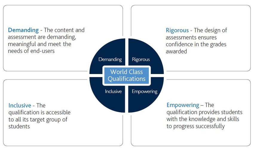
Issue 3 – March 2018 © Pearson Education Limited 2018Why choose Edexcel qualifications? Pearson – the world’s largest education company Edexcel academic qualifications are from Pearson, the UK’s largest awarding organisation. With over 3.4 million students studying our academic and vocational qualifications worldwide, we offer internationally recognised qualifications to schools, colleges and employers globally. Pearson is recognised as the world’s largest education company, allowing us to drive innovation and provide comprehensive support for Edexcel students to acquire the knowledge and skills they need for progression in study, work and life. A heritage you can trust The background to Pearson becoming the UK’s largest awarding organisation began in 1836, when a royal charter gave the University of London its first powers to conduct exams and confer degrees on its students. With over 150 years of international education experience, Edexcel qualifications have firm academic foundations, built on the traditions and rigour associated with Britain’s educational system. Results you can trust Pearson’s leading online marking technology has been shown to produce exceptionally reliable results, demonstrating that at every stage, Edexcel qualifications maintain the highest standards. Developed to Pearson’s world-class qualifications standards Pearson’s world-class standards mean that all Edexcel qualifications are developed to be rigorous, demanding, inclusive and empowering. We work collaboratively with a panel of educational thought leaders and assessment experts, to ensure that Edexcel qualifications are globally relevant, represent world-class best practice and maintain a consistent standard. For more information on the World Class Qualification process and principles please go to Appendix 8 or visit our website: uk.pearson.com/world-class-qualifications Pearson Edexcel International GCSE in Geography – Specification – 3 Issue 3 – March 2018 © Pearson Education Limited 2018
Why choose the Pearson Edexcel International
GCSE in Geography?
We have listened to feedback from all parts of the international subject community. Based
on that feedback, we have made changes that will engage students and give them
opportunities to gain skills that will support progression to further study of geography, and
to enhance their educational or employment prospects. This qualification enables students to
explore the world, the challenges it faces and their own place in it, and to help prepare them
to succeed in their chosen pathway. The content and assessment approach for this
qualification has been designed to meet students’ needs in the following ways.
Two-paper assessment – a new, two-paper model allows students to focus on physical
and human geography. The qualification will test knowledge and understanding, as well as
analytical, evaluation and fieldwork skills in both papers.
Concepts and content – the content in both Paper 1: Physical geography and Paper 2:
Human geography is engaging and accessible for all students. The material is appropriate
and relevant for progression, building understanding and awareness of a range of
geographical concepts and skills, including fieldwork.
Localised content: teachers can localise the fieldwork and content covered to suit the
needs and interests of a range of international learners in different regions.
Clear and straightforward question papers – our question papers are clear and
accessible for students of all ability ranges. A range of question styles will be used.
Our mark schemes are straightforward so that the assessment requirements are clear.
Broad and deep development of skills – the design of the revised International GCSE
aims to extend students’ knowledge by broadening and deepening skills. For example,
students will:
• develop and apply a holistic range of knowledge and understanding of geographical
  concepts and skills, including fieldwork
• present and analyse data, draw conclusions and evaluate information from different
  sources
• develop awareness of global issues and challenges and that, in moving towards a
  sustainable future, people have different views and attitudes to the environment.
Progression to A Level – International GCSEs enable successful progression to Level 3
qualifications (such as the International A Level in Geography) and beyond, in geography
and other subjects. Through our world-class qualification development process, we have
consulted international geography teaching experts to validate this qualification and endorse
its content, skills development and assessment structure.

4                                        Pearson Edexcel International GCSE in Geography – Specification
                                                Issue 3 – March 2018 © Pearson Education Limited 2018
Supporting you in planning and implementing this qualification Planning • Our Getting Started Guide gives you an overview of the Pearson Edexcel International GCSE in Geography to help you understand the changes to content and assessment, and to help you understand what these changes mean for you and your students. • We will provide you with a course planner and schemes of work. • Our mapping documents highlight key differences between the new and legacy qualifications. Teaching and learning • Our skills maps will highlight opportunities for students to develop skills that are assessed, as well as skills that are not directly assessed. • Print and digital learning and teaching resources promote ‘any time, any place’ learning to improve student motivation and encourage new ways of working. Preparing for exams We will provide a range of resources to help you prepare your students for the assessments, including: • specimen papers to support formative assessments and mock exams • examiner commentaries following each examination series. ResultsPlus ResultsPlus provides the most detailed analysis available of your students’ exam performance. It can help you identify the topics and skills where further learning would benefit your students. examWizard A free online resource designed to support students and teachers with exam preparation and assessment. Training events In addition to online training, we host a series of training events each year for teachers to deepen their understanding of our qualifications. Get help and support Our Subject Advisor service ensures that you receive help and guidance from us. You can sign up to receive updates at qualifications.pearson.com/en/subjects/geography or email 'sign me up' to teachinggeography@pearson.com Pearson Edexcel International GCSE in Geography – Specification – 5 Issue 3 – March 2018 © Pearson Education Limited 2018
Qualification at a glance

Paper overview
    Paper 1: Physical geography                                              *Paper code 4GE1/01
    • Externally assessed                                                    40% of the total
                                                                             International GCSE
    • Availability: June
    • First assessment: June 2019
    • 70 marks
    Content summary
    • River environments
    • Coastal environments
    • Hazardous environments
    including fieldwork from one of these topics
    Assessment
    Examination of 1 hour and 10 minutes, consisting of two sections. The questions are a
    mixture of multiple-choice, short-answer, data-response and open-ended questions.
    Section A
    Candidates choose two out of three questions on: river environments, coastal
    environments, hazardous environments.
    Section B
    Candidates choose one out of three fieldwork-related questions on: river environments,
    coastal environments, hazardous environments.

6                                           Pearson Edexcel International GCSE in Geography – Specification
                                                   Issue 3 – March 2018 © Pearson Education Limited 2018
Paper 2: Human geography *Paper code 4GE1/02
• Externally assessed 60% of the total
International GCSE
• Availability: June
• First assessment: June 2019
• 105 marks
Content summary
• Economic activity and energy
• Rural environments
• Urban environments
including fieldwork from one of these topics
• Global issues (Fragile environments and climate change, Globalisation and migration,
Development and human welfare)
Assessment
Examination of 1 hour and 45 minutes, consisting of three sections. The questions are a
mixture of multiple-choice, short-answer, data-response and open-ended questions.
Section A
Candidates choose two out of three questions on: economic activity and energy, rural
environments, urban environments.
Section B
Candidates choose one out of three fieldwork-related questions on: economic activity and
energy, rural environments, urban environments.
Section C
Candidates choose one out of three questions on: fragile environments and climate change,
globalisation and migration, development and human welfare.
* See Appendix 1 for a description of this code and all the other codes relevant to this
qualification.
Pearson Edexcel International GCSE in Geography – Specification – 7
Issue 3 – March 2018 © Pearson Education Limited 20188 Pearson Edexcel International GCSE in Geography – Specification
Issue 3 – March 2018 © Pearson Education Limited 20182 Geography content
Paper 1: Physical geography 11
Paper 2: Human geography 19
Pearson Edexcel International GCSE in Geography – Specification – 9
Issue 3 – March 2018 © Pearson Education Limited 2018Course structure
• The Pearson Edexcel International GCSE in Geography comprises two examinations.
• The Pearson Edexcel International GCSE in Geography is a linear qualification.
All examinations must be taken in the terminal series at the end of the course of study.
The content in detail
The specification content for each topic is divided into the following sections.
Key ideas
Each topic is divided into a number of key ideas that give a focus to the content.
Detailed content
Each key idea is broken down into detailed content that specifies what must be studied.
Examination questions will be based on this content.
Case studies and located examples
All students must study four in-depth case studies.
• In Paper 1, Section A: a case study of a developed country* and a developing country* or
an emerging country*.
• Paper 2, Section A: a case study of a developed country* and a developing country* or
an emerging country*.
In addition to four in-depth case studies, throughout the course it is a requirement to draw
on located examples from developing, emerging and developed countries. Any located
examples must be set within the broader contextual knowledge of the country.
In order to make it clear where a located example should be developed, a symbol has
been used.
Programmes of study could identify located examples within the countries selected for the
four in-depth case studies.
Geographical skills
Throughout their course of study, students are required to develop a range of geographical
skills, including quantitative skills. These skills may be assessed across any of the examined
papers. The full list of geographical skills is given on page 49.
Some geographical skills may only be assessed in specific topics. Examples of how these
skills could be used in particular topics are signposted in the detailed content and listed in
the ‘Integrated skills’ sections after each topic.
Abbreviations used
GDP – gross domestic product
GIS – geographic information system
IGO – intergovernmental organisation
NGO – non-governmental organisation
TNC – transnational corporation
* See Appendix 2 for definition of a developed, developing and emerging country.
10 Pearson Edexcel International GCSE in Geography – Specification
Issue 3 – March 2018 © Pearson Education Limited 2018Paper 1: Physical geography
Externally assessed
1.1 Description
This paper brings together physical geography and people-environment processes and
interactions. The paper is divided into two sections.
Section A – students choose two out of three topics from: river environments, coastal
environments, hazardous environments.
• Topic 1: River environments – features of the global hydrological cycle (including drainage
basins), the physical processes that give rise to distinct river landforms and detailed case
studies of river management in a developed and a developing or emerging country.
• Topic 2: Coastal environments – the processes that give rise to characteristic coastal
landforms, threats facing coastal ecosystems and detailed case studies of coastal
management in a developed and a developing or emerging country.
• Topic 3: Hazardous environments – the characteristics and distribution of different types
of natural hazard, the measurement and impacts of hazards and detailed case studies of
the management of an earthquake in a developed and a developing or emerging country.
Section B – students are required to undertake a geographical investigation involving
fieldwork and research, in one natural environment. In this paper, students choose one out
of three fieldwork-related questions from: river environments, coastal environments,
hazardous environments.
1.2 Assessment information
Examination length: 1 hour and 10 minutes.
Examination paper is in two sections.
Section A (50 marks).
Candidates choose two out of three questions on: river
environments, coastal environments, hazardous environments.
Section B (20 marks).
Candidates choose one out of three fieldwork-related questions
on: river environments, coastal environments, hazardous
environments.
Total for paper: 70 marks.
Pearson Edexcel International GCSE in Geography – Specification – 11
Issue 3 – March 2018 © Pearson Education Limited 20181.3 Subject content – Section A
Topic 1: River environments
What students need to learn
Key ideas Detailed content
1.1 The world’s water a) The hydrological cycle: characteristics, stores and transfers.
supply is contained in
b) Features of a drainage basin: source, watershed, channel
a closed system –
network, mouth.
the hydrological cycle
c) Factors affecting river regimes: precipitation, including storm
hydrographs, temperature, vegetation, land use, water
abstraction, dams. (1)
1.2 Physical processes a) Fluvial processes involved in river valley and river channel
give rise to formation: erosion (vertical and lateral), weathering and mass
characteristic river movement, transportation and deposition, and factors affecting
landforms these processes (climate, slope, geology, altitude and aspect).
b) How channel shape (width, depth), valley profile (long and
cross profiles), gradient, velocity, discharge, and sediment size
and shape change along the course of a named river . (2)
c) How river landscapes change over the course of a river, with
distinctive upland and lowland landforms, including the
formation of valleys, interlocking spurs, waterfalls, meanders,
oxbow lakes, flood plains and levees. (3)
Case studies of river management in a developed country and a developing country or an
emerging country.
1.3 River environments a) Uses of water, including agriculture, industry, human hygiene
are of great and leisure, and the rising demand for and supply of water:
importance to people areas of water shortage and water surplus.
and need to be
b) Reasons for variations in water quality, including pollution
sustainably managed
(sewage, industrial waste, agriculture) and the storage and
supply of clean water (dams and reservoirs, pipelines,
treatment works). (4)
c) Causes of river flooding, including rainfall intensity, seasonal
variations in discharge due to monsoons or snowmelt, relief,
urbanisation, and the prediction and prevention of flooding. (5)
Integrated skills
(1) Draw and interpret storm hydrographs using rainfall and discharge data.
(2) Use geology maps (paper or online) to link river long profiles to geology.
(3) Use GIS to map river systems.
(4) Use different maps (paper or online) to investigate the impact of human intervention.
(5) Use weather and climate data.
12 Pearson Edexcel International GCSE in Geography – Specification
Issue 3 – March 2018 © Pearson Education Limited 2018Topic 2: Coastal environments
What students need to learn
Key ideas Detailed content
2.1 Physical processes a) Physical processes at work on the coast: marine processes
and human (wave action, erosion, deposition and transportation, including
intervention give rise longshore drift), weathering (mechanical, chemical and
to characteristic biological) and mass movement (sliding and slumping).
coastal landforms
b) Influence of geology, vegetation, people and sea-level changes
on coastal environments. (1)
c) Role of erosional and depositional processes in the
development of landforms: headlands and bays, cliffs, wave-
cut platforms, caves, arches, stacks and stumps, beaches,
spits and bars. (2)
2.2 Distinctive a) Distributions and features of the world’s coastal ecosystems
ecosystems develop (coral reefs, mangroves, sand dunes and salt marshes). (3)
along particular
b) Abiotic and biotic characteristics of one named coastal
stretches of coastline
ecosystem . (4)
c) How small- and large-scale coastal ecosystems are threatened
by people and their activities (industrialisation, agricultural
practices, tourism and deforestation).
Case studies of coastal management in a developed country and a developing country or an
emerging country.
2.3 Coastal environments a) Conflicts between different users of the coast, with different
are of great views on coastal management (conservation or development).
importance to people
b) Causes of coastal flooding (storm surges, tsunamis, climate
and need to be
change) and the prediction and prevention of flooding
sustainably managed
(forecasting, building design, planning and education).
c) There are different coastal management strategies, including
soft engineering (beach replenishment, cliff regrading,
ecosystem rehabilitation and revegetation, managed retreat),
hard engineering (groynes, revetments, sea walls, gabions,
riprap) and shoreline management plans. (5)
Integrated skills
(1) Use maps (paper or online) to link coastal form to geology.
(2) Use GIS to map coastal systems.
(3) Use world maps to show the distribution of coastal ecosystems.
(4) Use and interpret nutrient cycle diagrams and food web diagrams.
(5) Use maps (paper or online) to indicate shoreline management plans.
Pearson Edexcel International GCSE in Geography – Specification – 13
Issue 3 – March 2018 © Pearson Education Limited 2018Topic 3: Hazardous environments
What students need to learn
Key ideas Detailed content
3.1 Some places are a) Characteristics, distribution and measurement of different
more hazardous than types of natural hazards including tropical cyclones,
others earthquakes and volcanoes. (1)
b) Causes of tropical cyclone hazards, including ocean
temperature, atmospheric pressure, wind shear and Coriolis
force.
c) Causes of volcanic and earthquake hazards, including the role
of plate boundaries and hotspots. (2)
3.2 Hazards have an a) Reasons why people continue to live in areas at risk from
impact on people and hazard events.
the environment
b) Some countries are more vulnerable (physically, socially and
economically) than others to the impacts of natural hazards.
c) The shorter-term and longer-term impacts of one earthquake
one volcano and one tropical cyclone hazard (3).
Case studies of hazard management for an earthquake in a developed country and a developing
country or an emerging country.
3.3 Earthquakes present a) Preparation for earthquakes (warning and evacuation, building
a hazard to many design, remote sensing and GIS). (4)
people and need to
b) Short-term responses and relief (emergency aid, shelter and
be managed carefully
supplies).
c) Longer-term planning (risk assessment, hazard mapping and
rebuilding programmes). (5)
Integrated skills
(1) Use world maps to show the distribution of different hazards.
(2) Use a range of different maps to show links between tectonic boundary and hazard type.
(3) Use social media sources, satellite images and socio-economic data to assess varying
impacts.
(4) Use GIS to investigate preparation for earthquake hazards.
(5) Use online data sources to research the range of shorter and longer-term responses for a
particular earthquake event.
14 Pearson Edexcel International GCSE in Geography – Specification
Issue 3 – March 2018 © Pearson Education Limited 20181.4 Assessment of fieldwork skills – Section B Fieldwork is assessed in Section B of Paper 1. Students are required to complete one geographical enquiry involving fieldwork relating to one topic in Paper 1. Paper 1: Physical geography • River environments. • Coastal environments. • Hazardous environments. Centres must ensure that: • Primary data collection includes quantitative and qualitative techniques. • Secondary data collection includes the use of at least two different secondary data sources for your chosen environment. Practical skills As part of – and in addition to – undertaking the geographical enquiry, students should acquire and be able to apply the following skills: • graphical skills – compiling graphs and flow lines, using proportional symbols, annotating maps, diagrams and photographs • map skills (including use of digital maps) – using grid references, understanding scales, recognising symbols, identifying landforms and human features of the landscape • photo-interpretation skills – reading vertical and oblique aerial photographs and satellite images, including GIS • sketching skills – communicating ideas through simple sketch maps and field sketches • spatial awareness – identifying the relative locations and relationships between features. Cognitive enquiry skills Students should acquire and be able to apply the following skills: • analysis of findings – reviewing and interpreting quantitative and qualitative information using appropriate media • use of statistical skills – simple descriptive statistics, such as lines of best fit, means, medians, modes, etc. • conflict resolution skills – identifying the views of interested people (stakeholders), recognising that stakeholders may have strongly different attitudes and feelings towards a particular issue • evaluation of findings – appraisal and review of data and information to see if they are accurate and suitable for the purpose, or misleading and unreliable. Pearson Edexcel International GCSE in Geography – Specification – 15 Issue 3 – March 2018 © Pearson Education Limited 2018
Fieldwork questions will include questions set in a familiar and unfamiliar fieldwork context.
Questions set in a familiar fieldwork context will require students to interpret, analyse,
evaluate and make judgements about their own fieldwork (AO3). They will also require
students to communicate their findings (AO4).
Questions set in an unfamiliar fieldwork context will be set in in the fieldwork environment
you have studied and will relate to the fieldwork investigation you have done (as set out in
column 4 in the table below), they will however use unfamiliar fieldwork data and students
will need to show that they can apply their fieldwork understanding and skills to interpret
and analyse this data.

16                                        Pearson Edexcel International GCSE in Geography – Specification
                                                 Issue 3 – March 2018 © Pearson Education Limited 2018
Contexts for fieldwork
Paper 1: Physical geography
Section B Geographical Suggested methods of What students need to
topic enquiry primary and secondary learn for unfamiliar
data collection for primary and
familiar fieldwork secondary fieldwork
contexts contexts in Paper 1
River Investigation of river Primary Primary
environments processes and form
through primary and
Quantitative Quantitative
secondary fieldwork
evidence e.g. (1) channel • River channel
measurements - velocity, characteristics: width,
width, depth and gradient depth and velocity
(2) measurements of • River gradient
sediment - size and shape
Qualitative
Qualitative
• Annotated field
e.g. (1) annotated field sketches
sketches of the river
channel and its features,
Secondary
(2) photographs to show
how the channel changes • GIS topographic map
downstream
Secondary
(1) A GIS topographic
map, e.g. from ArcGIS
Online or Google Earth,
(2) local secondary data
on river flows or regimes
Coastal Investigation of Primary Primary
environments coastal processes
and form through
Quantitative Quantitative
primary and
secondary fieldwork e.g. (1) sediment size and • Sediment: size and
evidence shape measurements, shape
beach profile survey, (2) • Beach profile
measurement of erosional
features - a cliff or
intertidal zone Qualitative
• Annotated field
sketches
Qualitative
e.g. (1) annotated field
sketches of particular Secondary
coastal features, (2) • Local geology map
photographs to show how
there are variations along
a stretch of the coast.
Pearson Edexcel International GCSE in Geography – Specification – 17
Issue 3 – March 2018 © Pearson Education Limited 2018Section B Geographical Suggested methods of primary What students
topic enquiry and secondary data collection need to learn
for familiar fieldwork contexts for unfamiliar
primary and
secondary
fieldwork
contexts in
Paper 1
Secondary
(1) A local geology map (paper or
digital), (2) local secondary data
on coastal change, e.g. historic
maps.
Hazardous Investigation of Primary Primary
environments physical processes
involved in an
Quantitative Quantitative
extreme weather
event through the e.g. (1) recording of a weather • Weather
recording of diary and local risk and hazard diary: wind,
primary and maps, (2) structured questionnaire rain,
secondary fieldwork about hazard perception temperature,
evidence and air
pressure
Qualitative
• Local risk and
e.g. (1) annotated field sketches hazard
to show evidence of an extreme mapping
weather event, (2) photographs /
video taken before, during and
Qualitative
after the extreme weather event
• Annotated
field sketches
Secondary
(1) An online feed from a local Secondary:
weather station, e.g
Wunderground, (2) local • Local live
feed of an
secondary data on weather events,
extreme
e.g. newspapers, online accounts.
weather
event.
18 Pearson Edexcel International GCSE in Geography – Specification
Issue 3 – March 2018 © Pearson Education Limited 2018Paper 2: Human geography
Externally assessed
2.1 Description
This paper brings together human geography and people-environment processes and
interactions. The paper is divided into three sections.
Section A – students choose two out of three topics from: economic activity and energy,
rural environments and urban environments.
• Topic 4: Economic activity and energy – variations in economic activity over time and
spatially, the relationship between population and resources and detailed case studies of
energy resource management in a developed and a developing or emerging country.
• Topic 5: Rural environments – distribution, characteristics and human activities taking
place in rural environments, the changes in contrasting rural environments and detailed
case studies of rural environments in a developed and a developing or emerging country.
• Topic 6: Urban environments – trends, characteristics and problems associated with
urban environments, the challenges facing contrasting urban environments and detailed
case studies of urban environments in a developed and a developing or emerging
country.
Section B – students are required to undertake a geographical investigation, involving
fieldwork and research, in one human environment. In this paper, students choose one out
of three fieldwork-related questions from: economic activity and energy, rural environments
and urban environments.
Section C – students are required to apply their knowledge and understanding of human and
physical geography to investigate broader global issues. Students choose one out of three
questions from: fragile environments and climate change, globalisation and migration, and
development and human welfare.
• Topic 7: Fragile environments and climate change – distribution, characteristics and
threats facing the world’s fragile environments, the impacts of different processes,
including climate change, on fragile environments, and different approaches to managing
fragile environments in a more sustainable way.
• Topic 8: Globalisation and migration – the characteristics and growth in globalisation,
including the role of global institutions and transnational corporations, and the impacts of
increased globalisation, including migration and tourism and different approaches to
managing migration and tourism in a more sustainable way.
• Topic 9: Development and human welfare – definitions and ways of measuring
development and human welfare, patterns of global development and the consequences
of variations in development, and different strategies to address uneven levels of
development and human welfare.
Pearson Edexcel International GCSE in Geography – Specification – 19
Issue 3 – March 2018 © Pearson Education Limited 20182.2 Assessment information
Examination length: 1 hour and 45 minutes.
Examination paper is in three sections.
Section A (50 marks).
Candidates choose two out of three questions on: economic
activity and energy, rural environments, and urban environments.
Section B (20 marks).
Candidates choose one out of three fieldwork-related questions
on: economic activity and energy, rural environments, and urban
environments.
Section C (35 marks).
Candidates choose one out of three questions on: fragile
environments and climate change, globalisation and migration,
and development and human welfare.
Total for paper: 105 marks.
20 Pearson Edexcel International GCSE in Geography – Specification
Issue 3 – March 2018 © Pearson Education Limited 20182.3 Subject content – Section A
Topic 4: Economic activity and energy
What students need to learn
Key ideas Detailed content
4.1 The relative a) Classification of employment by economic sector (primary,
importance of secondary, tertiary and quaternary) and the reasons for the
different economic differences in the employment structures in countries at
sectors and the different levels of development (Clark Fisher Model). (1)
location of economic
b) Factors affecting the location of economic activity in each
activity varies
economic sector and how these factors can change over time.
spatially, and
changes over time c) Reasons for the changes in the numbers of people employed in
each economic sector, including the availability of raw
materials, globalisation, mechanisation, demographic changes
and government policies.
4.2 The growth and a) Positive and negative impacts of economic sector shifts in a
decline of different named developed and a named developing or emerging
economic sectors has country . (2)
resulted in a range of
b) Informal employment: causes (economic development, rural-
impacts and possible
urban migration) and characteristics (advantages and
resource issues
disadvantages) in a named megacity . (3)
c) Different theories (Malthus and Boserup) are used to explain
the relationship between population and resources. (4)
Case studies of energy resource management in a developed country and a developing country
or an emerging country.
4.3 Countries a) Energy demand and production varies globally and is affected
increasingly by a range of factors: population growth, increased wealth and
experience an energy technological advances.
gap and therefore
b) Non-renewable, e.g. coal, oil, natural gas, uranium and shale
seek energy security
gas/oil, and renewable sources of energy, e.g. solar, wind,
by developing a
hydroelectric power (HEP), geothermal, biomass, have
balanced energy mix
advantages and disadvantages for people and the
and sustainable
environment.
energy use
c) Energy can be managed in a sustainable way through
education, efficiency and conservation (within industry,
transport and the home). (5)
Pearson Edexcel International GCSE in Geography – Specification – 21
Issue 3 – March 2018 © Pearson Education Limited 2018Integrated skills
(1) Draw and interpret triangular graphs to show the proportion of people employed in the
primary, secondary and tertiary/quaternary sector.
(2) Use numerical economic data to profile the chosen country.
(3) Interpret photographs and newspaper articles.
(4) Use and interpret line graphs showing changes in population and resources over time.
(5) Calculate carbon and ecological footprints.
22 Pearson Edexcel International GCSE in Geography – Specification
Issue 3 – March 2018 © Pearson Education Limited 2018Topic 5: Rural environments
What students need to learn
Key ideas Detailed content
5.1 Rural environments a) Distributions and characteristics of the world’s biomes
are natural (tropical, temperate and boreal forests, tropical and temperate
ecosystems that are grasslands, deserts and tundra). (1)
exploited by human
b) Examples of goods and services provided for people by natural
activities
ecosystems (timber, tourism, food, energy, water resources,
health services, natural protection, and climate regulation).
c) How humans use, modify and change ecosystems and rural
environments to obtain food through farming systems
(arable/pastoral, commercial/subsistence,
intensive/extensive). (2)
5.2 Rural environments a) Characteristics of a rural environment: landscape, climate,
have contrasting settlement, population, land use, employment, accessibility,
physical, social and management (development or conservation).
economic
b) Factors leading to rural changes in a named developed country
characteristics and
: rural isolation, decline in farm employment, tourist
are experiencing
pressures, suburbanisation, counter-urbanisation, and the
significant changes
negative multiplier effect.
c) Factors leading to rural changes in a named developing
country or emerging country : population growth,
changing farm economy and landholdings, natural hazards,
and rural-urban migration. (3)
Case studies of rural environments in a developed country and in a developing country or an
emerging country.
5.3 Rural environments a) The diversification of farming to generate new income streams:
need to adapt to be GM crops, specialist crops and food, organic farming,
socially, economically recreation and leisure. (4)
and environmentally
b) The range of possible strategies aimed at making rural living
sustainable
more sustainable and improving the quality of life (soil and air
quality, water supplies, crop yields, health, employment and
housing) for the chosen rural environment. (5)
c) Role of different groups of people (national and local
government, IGOs, NGOs and local communities) in managing
the social, economic and environmental challenges within the
chosen rural environment.
Pearson Edexcel International GCSE in Geography – Specification – 23
Issue 3 – March 2018 © Pearson Education Limited 2018Integrated skills
(1) Use world maps to show the location of biomes.
(2) Use flow diagrams to represent the effects of different human activities on ecosystems and
rural environments.
(3) Use and interpret population pyramids.
(4) Use photographs, marketing and social media to investigate diversification.
(5) Use socio-economic data to provide evidence that the quality of life has improved.
24 Pearson Edexcel International GCSE in Geography – Specification
Issue 3 – March 2018 © Pearson Education Limited 2018Topic 6: Urban environments
What students need to learn
Key ideas Detailed content
6.1 A growing a) Contrasting trends in urbanisation over the last 50 years in
percentage of the different parts of the world, including the processes of
world’s population suburbanisation and counter-urbanisation. (1)
lives in urban areas
b) Factors affecting the rate of urbanisation and the emergence of
megacities.
c) Problems associated with rapid urbanisation: congestion,
transport, employment, crime and environmental issues. (2)
6.2 Cities face a range of a) Factors affecting urban land use patterns: locational needs,
social and accessibility, land values. (3)
environmental
b) Urban challenges in a named developed country : food,
challenges resulting
energy, transport and waste disposal demands, concentrated
from rapid growth
resource consumption, segregation. (4)
and resource
demands c) Urban challenges in a named developing country or
emerging country : squatter settlements, informal economy,
urban pollution, and low quality of life.
Case studies of urban environments in a developed country and a developing country or an
emerging country.
6.3 Different strategies a) Development of the rural-urban fringe: housing estates, retail,
can be used to business and science parks, industrial estates, and the
manage social, greenfield versus brownfield debate.
economic and
b) The range of possible strategies aimed at making urban living
environmental
more sustainable and improving the quality of life (waste
challenges in a
disposal, transport, education, health, employment and
sustainable manner
housing) for the chosen urban environment. (5)
c) Role of different groups of people (planners, politicians,
property developers and industrialists) in managing the social,
economic and environmental challenges in the chosen urban
area.
Integrated skills
(1) Use world maps to show the trends in urbanisation over the last 50 years.
(2) Interpret photographs and different maps (paper or online) to investigate the impacts of
rapid urbanisation.
(3) Use satellite images to identify different land uses in the chosen urban environment.
(4) Use and interpret socio-economic data.
(5) Use quantitative and qualitative information to judge the scale in variations in
environmental quality.
Pearson Edexcel International GCSE in Geography – Specification – 25
Issue 3 – March 2018 © Pearson Education Limited 20182.4 Assessment of fieldwork skills – Section B
Fieldwork is assessed in Section B of Paper 2. Students are required to complete one
geographical enquiry involving fieldwork relating to one topic in Paper 2.
Paper 2: Human geography
• Economic activity and energy.
• Rural environments.
• Urban environments.
Centres must ensure that:
• Primary data collection includes quantitative and qualitative techniques.
• Secondary data collection includes the use of at least two different secondary data
sources for your chosen environment.
Practical skills
As part of – and in addition to – undertaking the geographical enquiry, students should
acquire and be able to apply the following skills:
• graphical skills – compiling graphs and flow lines, using proportional symbols,
annotating maps, diagrams and photographs
• map skills (including use of digital maps) – using grid references, understanding scales,
recognising symbols, identifying landforms and human features of the landscape
• photo-interpretation skills – reading vertical and oblique aerial photographs and
satellite images, including GIS
• sketching skills – communicating ideas through simple sketch maps and field sketches
• spatial awareness – identifying the relative locations and relationships between
features.
Cognitive enquiry skills
Students should acquire and be able to apply the following skills:
• analysis of findings – reviewing and interpreting quantitative and qualitative
information using appropriate media
• use of statistical skills – simple descriptive statistics, such as lines of best fit, means,
medians, modes, etc.
• conflict resolution skills – identifying the views of interested people (stakeholders),
recognising that stakeholders may have strongly different attitudes and feelings towards
a particular issue
• evaluation of findings – appraisal and review of data and information to see if these are
accurate and suitable for the purpose, or misleading and unreliable.
26 Pearson Edexcel International GCSE in Geography – Specification
Issue 3 – March 2018 © Pearson Education Limited 2018Fieldwork questions will include questions set in a familiar and unfamiliar fieldwork context. Questions set in a familiar fieldwork context will require students to interpret, analyse, evaluate and make judgements about their own fieldwork (AO3). They will also require students to communicate their findings (AO4). Questions set in an unfamiliar fieldwork context will be set in in the fieldwork environment you have studied and will relate to the fieldwork investigation you have done (as set out in column 4 in the table below), they will however use unfamiliar fieldwork data and students will need to show that they can apply their fieldwork understanding and skills to interpret and analyse this data (AO3) and communicate their findings (AO4). Pearson Edexcel International GCSE in Geography – Specification – 27 Issue 3 – March 2018 © Pearson Education Limited 2018
Contexts for fieldwork
                                 Paper 2: Human geography

     Section B    Geographical       Suggested methods of                 What students need to
       topic        enquiry          primary data collection                know for Paper 2

Economic         Investigating     Primary                               Primary
activity and     changing energy
energy           use through
                                   Quantitative                          Quantitative
                 primary and
                 secondary         e.g. (1) environmental quality        • Small scale
                 evidence          survey, and a structured                 environmental quality
                                   questionnaire, (2) visual               survey (EQS)
                                   assessment of landscape               • Structured
                                                                           questionnaire including
                                                                           closed questions
                                   Qualitative
                                   e.g. (1) annotated
                                                                         Qualitative
                                   photographs showing
                                   evidence of changing energy           • Annotated photographs
                                   use, (2) interviews with
                                   different stakeholders
                                                                         Secondary
                                                                         • Local report on energy
                                   Secondary                               use
                                   (1) A local report (paper or
                                   digital) into people’s / or the
                                   region's energy use, (2) local
                                   secondary data on landscape
                                   change from an energy
                                   development, e.g. historic
                                   maps and images.

28                                      Pearson Edexcel International GCSE in Geography – Specification
                                               Issue 3 – March 2018 © Pearson Education Limited 2018
Section B Geographical enquiry Suggested methods What students need to
topic of primary data know for Paper 2
collection
Rural Investigating the Primary Primary
environments changing use of rural
environments through
Quantitative Qualitative
primary and secondary
evidence e.g. (1) environmental • Small scale
quality survey, and a environmental quality
structured survey (EQS)
questionnaire, (2) • Structured
landscape or building questionnaire including
assessment survey closed questions
Qualitative Quantitative
e.g. (1) annotated • Annotated photographs
photographs showing
evidence of changing
Secondary
rural environments,
(2) interviews with • Report on change in a
different stakeholders local rural community
Secondary
(1) A local report
(paper or digital) into
an aspect of change in
a rural area and
community, (2) local
secondary data on
landscape change from
development, e.g.
historic maps and
images.
Pearson Edexcel International GCSE in Geography – Specification – 29
Issue 3 – March 2018 © Pearson Education Limited 2018Section B Geographical enquiry Suggested methods What students need to
topic of primary data know for Paper 2
collection
Urban Investigating the Primary Primary
environments changing use of
central/inner urban
Quantitative Quantitative
environments through
primary and secondary e.g. (1) environmental • Small scale
evidence quality survey, and a environmental quality
structured survey (EQS)
questionnaire, (2) • Structured
urban land use survey questionnaire including
closed questions
Qualitative
Quantitative
e.g. (1) annotated
photographs showing • Annotated photographs
evidence of changing
rural environments,
Secondary:
(2) interviews with
different stakeholders • Report on change in a
local urban community
Secondary
(1) A local report
(paper or digital) into
an aspect of change in
an urban area and
community, (2) local
secondary data on
urban change from
development, e.g.
historic maps and
images.
30 Pearson Edexcel International GCSE in Geography – Specification
Issue 3 – March 2018 © Pearson Education Limited 20182.5 Subject content – Section C (Global issues)
Topic 7: Fragile environments and climate change
What students need to learn
Key ideas Detailed content
7.1 Fragile environments a) Distributions and characteristics of the world’s fragile
are under threat environments. (1)
from desertification,
b) Causes of desertification (drought, population pressure, fuel
deforestation and
supply, overgrazing, migration) and deforestation (commercial
global climate change
timber extraction, agriculture, mining, transport; settlement
and HEP (hydroelectric power).
(2) and (3)
c) Causes of natural climate change (Milankovitch cycles, solar
variation and volcanism) and how human activities (industry,
transport, energy, and farming) can cause the enhanced
greenhouse effect. (4)
7.2 There are various a) Social, economic and environmental impacts of desertification
impacts of (reduced agricultural output, malnutrition, famine, migration).
desertification,
b) Social, economic and environmental impacts of deforestation
deforestation and
(loss of biodiversity, contribution to climate change, economic
climate change on
development and increased soil erosion).
fragile environments
c) Negative effects that climate change is having on fragile
environments and people (rising sea levels, more hazards,
ecosystem changes, reduced employment opportunities,
changing settlement patterns, health and wellbeing challenges,
including food supply). (5)
7.3 The responses to a) How technology can resolve water-resource shortages in fragile
desertification, environments under threat from desertification.
deforestation and
b) Different approaches to the sustainable use and management
climate change vary
of a rainforest in a named region to limit the extent of
depending on a
deforestation.
country’s level of
development c) Different responses to global warming and climate change from
individuals, organisations and governments in a named
developed and a named emerging or developing country .
Integrated skills
(1) Use world maps to show the location of fragile environments.
(2) Use and interpret line graphs showing past and predicted global population growth, and
population in relation to likely resources.
(3) Use maps (paper and online) to identify the pattern of deforestation.
(4) Use and interpret graphs and maps to show human causes of climate change.
(5) Use and interpret line graphs/bar charts showing climate change and sea level change.
Pearson Edexcel International GCSE in Geography – Specification – 31
Issue 3 – March 2018 © Pearson Education Limited 2018Topic 8: Globalisation and migration
What students need to learn
Key ideas Detailed content
8.1 Globalisation is a) Rise of the global economy (growth of production and
creating a more commodity chains) and the factors encouraging it (trade,
connected world, foreign investment, aid, labour, modern transport and
with increased information technologies). (1)
movements of goods
b) Role of global institutions, including the World Trade
(trade) and people
Organization (WTO), the International Monetary Fund
(migration and
(IMF) and TNCs in creating a more globalised economy.
tourism) worldwide
c) Push and pull factors (social, economic and political) that
have influenced rates of different types of migration over
the last 50 years, including medical, sport, tourism and
economic. (2)
8.2 The impacts of a) Impacts of globalisation on different groups of people,
globalisation vary on including the benefits and costs to countries hosting
a global scale TNCs. (3)
b) Impacts of migration (voluntary, forced, national,
international, and rural-urban) on different groups of
people. (4)
c) Positive and negative impacts of the growth of global
tourism, including mass tourism, on the environment,
economy and people of destination areas. (5)
8.3 The responses to a) How geopolitical relationships between countries are
increased migration important in managing trade, migration and tourism.
and tourism vary
b) Different approaches to the management of long-term
depending on a
migration in a named country .
country’s level of
development c) Different approaches to make tourism more sustainable
from individuals, organisations and governments in a
named developed and a named emerging or
developing country .
Integrated skills
(1) Use and interpret line graphs/bar charts showing changes in the global economy over
the past 50 years.
(2) Use maps (paper and online) to identify patterns of migration.
(3) Interpret photographs and newspaper articles.
(4) Use and interpret graphs to show rates of population movement over the past 50
years.
(5) Use and interpret socio-economic data.
32 Pearson Edexcel International GCSE in Geography – Specification
Issue 3 – March 2018 © Pearson Education Limited 2018You can also read