International Ocean Discovery Program Expedition 371 Preliminary Report - Tasman Frontier Subduction Initiation and Paleogene Climate
←
→
Page content transcription
If your browser does not render page correctly, please read the page content below
International Ocean Discovery Program
      Expedition 371 Preliminary Report
         Tasman Frontier Subduction Initiation and
                   Paleogene Climate

                        27 July–26 September 2017

Rupert Sutherland, Gerald R. Dickens, Peter Blum, and the Expedition 371 Scientists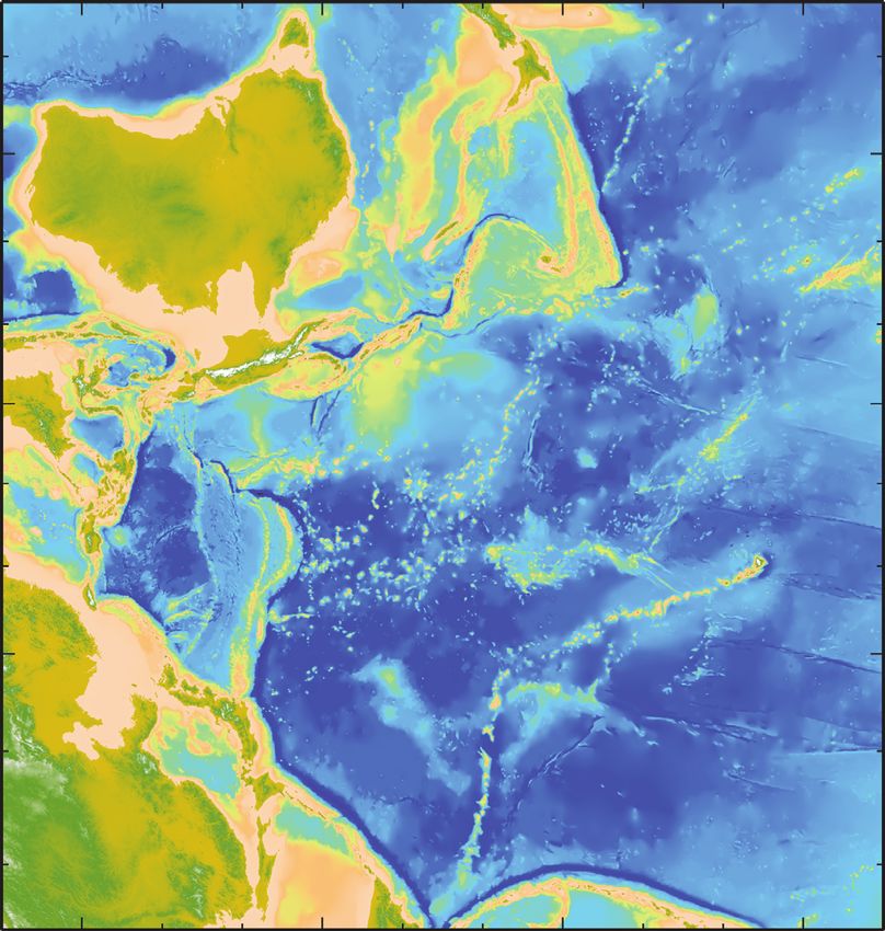
Publisher’s notes
  Core samples and the wider set of data from the science program covered in this report are under
moratorium and accessible only to Science Party members until 2 February 2019.
   This publication was prepared by the JOIDES Resolution Science Operator (JRSO) at Texas A&M
University (TAMU) as an account of work performed under the International Ocean Discovery
Program (IODP). Funding for IODP is provided by the following international partners:
    National Science Foundation (NSF), United States
    Ministry of Education, Culture, Sports, Science and Technology (MEXT), Japan
    European Consortium for Ocean Research Drilling (ECORD)
    Ministry of Science and Technology (MOST), People’s Republic of China
    Korea Institute of Geoscience and Mineral Resources (KIGAM)
    Australia-New Zealand IODP Consortium (ANZIC)
    Ministry of Earth Sciences (MoES), India
    Coordination for Improvement of Higher Education Personnel (CAPES), Brazil
   Portions of this work may have been published in whole or in part in other IODP documents or
publications.

Disclaimer
   Any opinions, findings, and conclusions or recommendations expressed in this publication are
those of the author(s) and do not necessarily reflect the views of the participating agencies, TAMU, or
Texas A&M Research Foundation.

Copyright
    Except where otherwise noted, this work is licensed under the Creative Commons
Attribution 4.0 International (CC BY 4.0) license (https://creativecommons.org/
licenses/by/4.0/). Unrestricted use, distribution, and reproduction are permitted,
provided the original author and source are credited.

Citation
Sutherland, R., Dickens, G.R., Blum, P., and the Expedition 371 Scientists, 2018. Expedition 371 Preliminary Report:
    Tasman Frontier Subduction Initiation and Paleogene Climate. International Ocean Discovery Program.
    https://doi.org/10.14379/iodp.pr.371.2018

ISSN
World Wide Web: 2372-9562

                                                   January 2018
R. Sutherland et al.                                                                                   Expedition 371 Preliminary Report

Expedition 371 participants
Expedition 371 scientists
Rupert Sutherland                                                  Margot J. Cramwinckel
Co-Chief Scientist                                                 Organic Geochemist/Palynologist
   Department of Geography, Environment, Earth Sciences               Department of Earth Sciences
   Victoria University of Wellington                                  Utrecht University
   New Zealand                                                        The Netherlands
   rupert.sutherland@vuw.ac.nz                                        m.j.cramwinckel@uu.nl
Gerald R. Dickens                                                  Edoardo Dallanave
Co-Chief Scientist                                                 Paleomagnetist
   Department of Earth, Environmental and Planetary Sciences          Department of Earth and Environmental Sciences, Geophysics
   Rice University                                                       Section
   USA                                                                Ludwig-Maximilians-Universität München
   jerry@rice.edu                                                     Germany
                                                                      dallanave@geophysik.uni-muenchen.de
Peter Blum
Expedition Project Manager/Staff Scientist                         Michelle K. Drake
   International Ocean Discovery Program                           Sedimentologist
   Texas A&M University                                               Ocean Sciences Department
   USA                                                                University of California, Santa Cruz
   blum@iodp.tamu.edu                                                 USA
                                                                      mkdrake@ucsc.edu
Claudia Agnini
Paleontologist (nannofossils)                                      Samuel J.G. Etienne
   Dipartimento di Geoscienze                                      Sedimentologist
   Università degli Studi di Padova                                   Department of Industry, Mines and Energy of New Caledonia
   Italy                                                              Geological Survey of New Caledonia
   claudia.agnini@unipd.it                                            New Caledonia
                                                                      samuel.etienne@gouv.nc
Laia Alegret
Paleontologist (foraminifers)                                      Martino Giorgioni
   Departamento de Ciencias de la Tierra (Paleontología)           Sedimentologist
   Universidad de Zaragoza                                            Instituto de Geociência
   Spain                                                              Universidade de Brasília
   laia@unizar.es                                                     Brazil
                                                                      gmartino@unb.br
Joyeeta Bhattacharya
Sedimentologist                                                    Michael Gurnis
   Department of Earth, Environmental and Planetary Sciences       Physical Properties Specialist
   Rice University                                                    Seismological Laboratory
   USA                                                                California Institute of Technology
   jb79@rice.edu                                                      USA
                                                                      gurnis@gps.caltech.edu
Aurelien Bordenave
Sedimentologist                                                    Dustin T. Harper
   Geological Survey of New Caledonia                              Stratigraphic Correlator
   New Caledonia                                                      Department of Earth and Planetary Sciences
   aurelien.bordenave@gouv.nc                                         University of California, Santa Cruz
                                                                      USA
Liao Chang
                                                                      dtharper@ucsc.edu
Paleomagnetist
   School of Earth and Space Sciences                              Huai-Hsuan May Huang
   Peking University                                               Paleontologist (ostracods)
   China                                                              Atmosphere and Ocean Research Institute
   liao.chang@pku.edu.cn                                              The University of Tokyo
                                                                      Japan
Julien Collot
                                                                      huanghuaihsuan@gmail.com
Physical Properties Specialist
    Geological Survey of New Caledonia
    New Caledonia
    julien.collot@gouv.nc

                                                               3
R. Sutherland et al.                                                                              Expedition 371 Preliminary Report

Allison L. Keller                                             Stephen F. Pekar
Sedimentologist                                               Sedimentologist
    Department of Earth Sciences                                 School of Earth and Environmental Sciences
    University of California, Riverside                          Queens College (CUNY)
    USA                                                          USA
    akell002@ucr.edu                                             stephen.pekar@qc.cuny.edu
Adriane R. Lam                                                Donald E. Penman
Paleontologist (foraminifers)                                 Sedimentologist
   Department of Geosciences                                     Department of Geology and Geophysics
   University of Massachusetts                                   Yale University
   USA                                                           USA
   arlam@geo.umass.edu                                           donald.penman@yale.edu
He Li                                                         Saneatsu Saito
Inorganic Geochemist                                          Physical Properties Specialist
   Institute of Oceanology, Chinese Academy of Sciences          Research and Development Center for Ocean Drilling Science
   China                                                         Japan Agency for Marine-Earth Science and Technology
   lihe@qdio.ac.cn                                               Japan
                                                                 saito@jamstec.go.jp
Hiroki Matsui
Paleontologist (foraminifers)                                 Wanda R. Stratford
   Department of Earth Science                                Physical Properties Specialist
   Tohoku University                                             Marine Geosciences
   Japan                                                         GNS Science
   hmatsui531@gmail.com                                          New Zealand
                                                                 w.stratford@gns.cri.nz
Cherry Newsam
Paleontologist (nannofossils)                                 Thomas Westerhold
   Department of Earth Sciences                               Stratigraphic Correlator
   University College London                                     Center for Marine Environmental Sciences (MARUM)
   United Kingdom                                                University of Bremen
   cherry.newsam.11@ucl.ac.uk                                    Germany
                                                                 twesterhold@marum.de
Yu-Hyeon Park
Organic Geochemist                                            Xiaoli Zhou
   Department of Oceanography                                 Inorganic Geochemist
   Pusan National University                                     Institute of Marine and Coastal Sciences
   Republic of Korea                                             Rutgers, The State University of New Jersey
   parky@pusan.ac.kr                                             USA
                                                                 xiaoli.zhou@rutgers.edu
Kristina M. Pascher
Paleontologist (radiolarians)
   GNS Science
   New Zealand
   kristina.pascher@gmail.com

Observers
Gayane Asatryan                                               Hugh E.G. Morgans
Observer/Paleontologist (radiolarians)                        Observer/Paleontologist (foraminifers)
   School of Earth and Environmental Sciences                   Paleontology and Environmental Change Section
   University of Queensland                                     GNS Science
   Australia                                                    New Zealand
   g.asatryan@uq.edu.au                                         h.morgans@gns.cri.nz

Education and outreach
Debra E. Beamish                                              Adam J. Kurtz
Education/Outreach Officer                                    Education/Outreach Officer
   Australia                                                     USA
   beamish5@tpg.com.au                                           adamkurtz47@gmail.com

                                                          4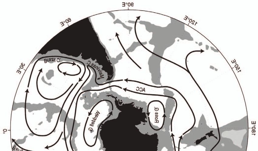
R. Sutherland et al.                                                                     Expedition 371 Preliminary Report

Operational and technical staff
Siem Offshore AS officials
Steve Bradley                                        Mark Robinson
Master of the Drilling Vessel                        Offshore Installation Manager
Jake Robinson
Master of the Drilling Vessel

JRSO shipboard personnel and technical representatives
Timothy Blaisdell                                    Randy Gjesvold
Applications Developer                               Marine Instrumentation Specialist
Susan Boehm                                          Michael Hodge
Thin Section Laboratory                              Marine Computer Specialist
Inva Braha                                           Minh Huynh
Marine Laboratory Specialist (temporary)             Marine Computer Specialist
Lisa Brandt                                          Nicolette Lawler
Chemistry Laboratory                                 X-Ray Laboratory
Chad Broyles                                         Daniel Marone
Curatorial Specialist                                Marine Laboratory Specialist (temporary)
Lisa Crowder                                         Aaron Mechler
Assistant Laboratory Officer                         Chemistry Laboratory
Douglas Cummings                                     Mike Meiring
Publications Specialist                              Electronics Specialist
Aaron de Loach                                       Stephen Midgley
Core Laboratory                                      Operations Superintendent
Keith Dupuis                                         William Mills
Underway Geophysics Laboratory                       Laboratory Officer
Sheryl Frazier                                       Beth Novak
Physical Properties Laboratory                       Paleomagnetism Laboratory
Timothy Fulton                                       Garrick Van Rensburg
Imaging Specialist                                   Marine Instrumentation Specialist
Luke Furfey                                          Rui Wang
Marine Laboratory Specialist (temporary)             Applications Developer
Clayton Furman
Logging Engineer (Schlumberger)

                                                 5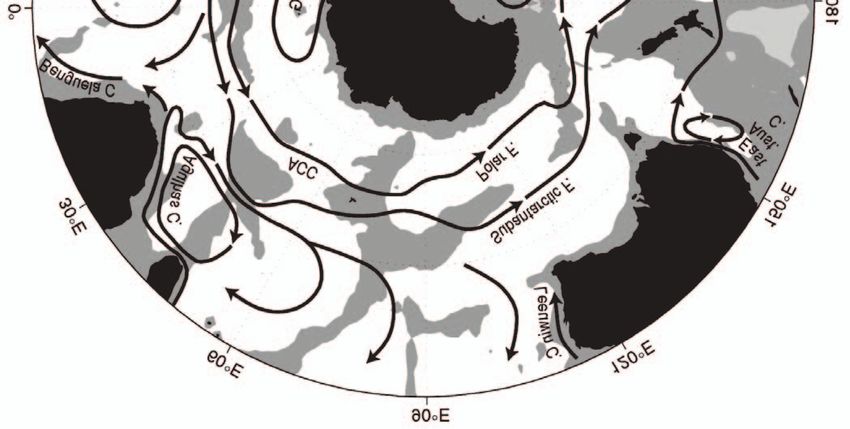
R. Sutherland et al. Expedition 371 Preliminary Report
Abstract Eocene tectonic change occurred at a turning point in Cenozoic
climate. Long-term global warming through the Paleocene–Eocene
International Ocean Discovery Program (IODP) Expedition 371 transition culminated in the Early Eocene Climate Optimum
drilled six sites in the Tasman Sea of the southwest Pacific between (EECO; ~53–49 Ma), which was followed by overall cooling
27 July and 26 September 2017. The primary goal was to understand through the remainder of the Cenozoic (Figure F5) (Zachos et al.,
Tonga-Kermadec subduction initiation through recovery of Paleo- 2008). A secondary scientific goal of Expedition 371 was to address
gene sediment records. Secondary goals involved understanding re- the question of why Earth’s climate might move between multimil-
gional oceanography and climate since the Paleogene. Six sites were lion-year greenhouse and icehouse climate states. Under very high
drilled, recovering 2506 m of cored sediment and volcanic rock in pCO2 conditions or high climate sensitivity, global climate models
36.4 days of on-site drilling during a total expedition length of 58 (Huber and Caballero, 2011; Lunt et al., 2012) can reasonably simu-
days. Wireline logs were collected at two sites. Shipboard observa- late early Eocene warming in many regions (Douglas et al., 2014;
tions made using cores and logs represent a substantial gain in fun- Tripati et al., 2003) but not the extreme warmth previously reported
damental knowledge about northern Zealandia, because only Deep in the southwest Pacific and Southern Ocean (Bijl et al., 2009; Hollis
Sea Drilling Project Sites 206, 207, and 208 had penetrated beneath et al., 2009, 2012; Pross et al., 2012).
upper Eocene strata within the region. The Eocene–Oligocene transition and Neogene paleoceano-
The cored intervals at five sites (U1506–U1510) sampled graphy have been subjects of numerous scientific drilling expedi-
nannofossil and foraminiferal ooze or chalk that contained volcanic tions, including Deep Sea Drilling Project (DSDP) Legs 21, 29, and
or volcaniclastic intervals with variable clay content. Paleocene and 90 in the Tasman Sea (Figure F2), which were highly influential in
Cretaceous sections range from more clay rich to predominantly the development of ideas that connected regional oceanography
claystone. At the final site (U1511), a sequence of abyssal clay and with thermal isolation and glaciation of Antarctica and hence global
diatomite was recovered with only minor amounts of carbonate. climate change (Burns and Andrews, 1973; Kennett, 1977; Kennett
The ages of strata at the base of each site were middle Eocene to et al., 1975; Kennett and von der Borch, 1986). Ocean Drilling Pro-
Late Cretaceous, and our new results provide the first firm basis for gram (ODP) Legs 181 and 189 further investigated the Eocene–Oli-
defining formal lithostratigraphic units that can be mapped across a gocene opening of the southern Tasman Sea gateway (Carter et al.,
substantial part of northern Zealandia and related to onshore re- 2004; Exon et al., 2004b). However, the significance of unconformi-
gions of New Caledonia and New Zealand. ties in the Tasman Sea has not, so far, included consideration of re-
The material and data recovered during Expedition 371 enable gional vertical tectonics or local faulting (Sutherland et al., 2010,
primary scientific goals to be accomplished. All six sites provided 2017). Records from the Tasman Sea may also offer insights into un-
new stratigraphic and paleogeographic information that can be put derstanding Neogene paleoceanography across the Pacific and phe-
into context through regional seismic-stratigraphic interpretation nomena such as the late Miocene–early Pliocene biogenic bloom
and hence provide strong constraints on geodynamic models of (Farrell et al., 1995; Grant and Dickens, 2002).
subduction zone initiation. Our new observations can be directly
related to the timing of plate deformation, the magnitude and tim-
ing of vertical motions, and the timing and type of volcanism. Sec-
Scientific background
ondary paleoclimate objectives were not all completed as planned, Subduction initiation and global plate tectonics
but significant new records of southwest Pacific climate were ob- Subduction initiation and changes in plate motion are linked be-
tained. cause the largest driving and resisting tectonic forces occur within
subduction zones (Becker and O’Connell, 2001; Buffett, 2006; Lith-
Introduction gow-Bertelloni and Richards, 1998; Stadler et al., 2010). There are
two end-member classes of subduction initiation models: induced
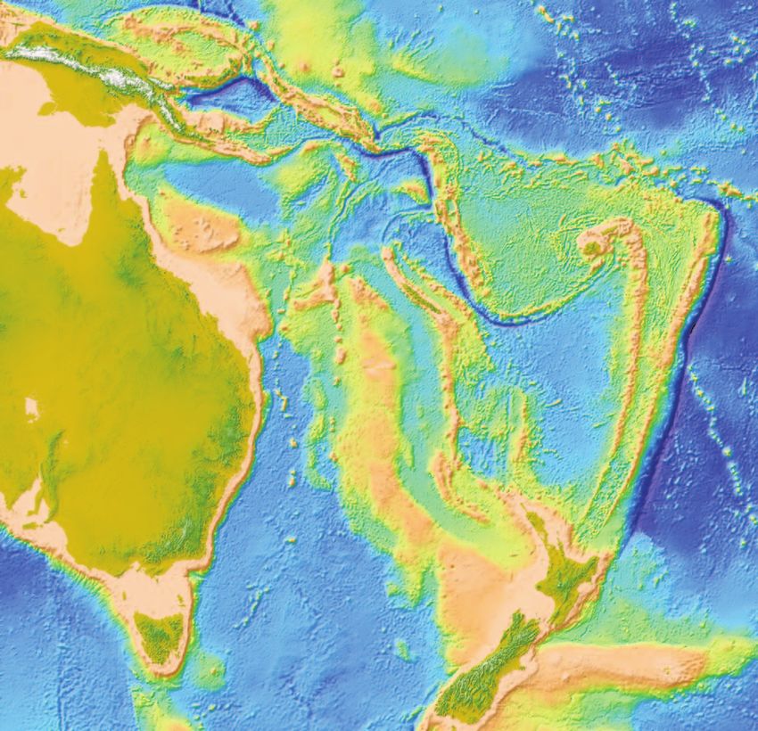
The Tasman Frontier represents an extensive and under-ex- or spontaneous (Stern, 2004) (Figure F6). In the spontaneous
plored area of the ocean between Australia, New Zealand, and New model, oceanic lithosphere ages, cools, increases in density and
Caledonia (Figure F1). The primary goal of Integrated Ocean Drill- gravitational instability, and sinks into the mantle under its own
ing Program (IODP) Expedition 371 was to understand Tonga-Ker- weight (Stern and Bloomer, 1992; Turcotte et al., 1977). In the in-
madec subduction initiation through recovery of Paleogene duced model, externally applied compressive stress and conver-
sediment records at six new sites across the Tasman Frontier (Fig- gence is necessary to overcome lithospheric strength before
ures F1, F2, F3, F4). convective instability can grow and subduction initiation occurs
Subduction systems are primary drivers of plate motions, man- (McKenzie, 1977; Toth and Gurnis, 1998).
tle dynamics, and global geochemical cycles, but little is known Half of all presently active subduction zones on Earth initiated
about how subduction starts. What are the initial conditions? How during the Cenozoic (Gurnis et al., 2004), so it is possible to assem-
do forces and kinematics evolve? What are the short-term conse- ble observations to address the question of how and why these mar-
quences and surface signatures: uplift, subsidence, deepwater sedi- gins evolved into self-sustaining subduction zones. Recent drilling
mentary basins, convergence, extension, and volcanism? The early results from Expedition 351 shed new light on this question, and
Eocene onset of subduction in the western Pacific was accompanied new models suggest juxtaposition of a transcurrent fault and relict
by a profound global reorganization of tectonic plates, with known arc could have led to Izu-Bonin-Mariana subduction initiation just
plate motions before and after the change (Billen and Gurnis, 2005; before 50 Ma (Leng and Gurnis, 2015). Subduction initiation at a
Sharp and Clague, 2006; Steinberger et al., 2004; Whittaker et al., passive continental margin has received considerable attention
2007). The Izu-Bonin-Mariana (e.g., IODP Expeditions 350, 351, through the concept of a Wilson cycle (a class of the spontaneous
and 352) and Tonga-Kermadec systems contain complementary in- model), but there are no known Cenozoic examples of passive mar-
formation about subduction initiation (Figure F1), but the south- gins evolving into subduction zones (Stern, 2004). Spontaneous and
west Pacific has had little relevant drilling. induced models predict different states of stress and vertical mo-
6
R. Sutherland et al.                                                                                                      Expedition 371 Preliminary Report

tions during their early stages, and the aim to distinguish these un-             through early Eocene, the hyperthermal events of the early Eocene,
derpinned our drilling strategy.                                                  the EECO, and subsequent cooling can be found in sedimentary
     The largest change in global plate motions since 83 Ma (the only             successions of eastern New Zealand (Dallanave et al., 2015; Han-
period with precisely known plate kinematics) is manifest as the                  cock et al., 2003; Hollis, 2006; Hollis et al., 2005; Nicolo et al., 2010,
Emperor-Hawaii seamount chain bend (Figure F1). Geochronology                     2007; Slotnick et al., 2012).
shows that the Emperor-Hawaii bend started at ~50 Ma and may                          Why did Earth’s climate generally cool since about 49 Ma? Most
have occurred over ~8 My (Sharp and Clague, 2006). The onset of                   hypotheses have invoked changes in the amount of volcanism or
Pacific plate motion change corresponds to the timing of Pa-                      weathering, which would affect carbon addition to or carbon re-
cific/Farallon plate boundary rearrangement (Caress et al., 1988)                 moval from the ocean and atmosphere (Brinkhuis et al., 2006; Kent
and termination of spreading in the Tasman Sea (Gaina et al., 1998),              and Muttoni, 2008). It has been suggested that Eocene tectonic
followed by a change in direction and rapid increase in rate of Aus-              change drove long-term Cenozoic climate change (Lee et al., 2013;
tralia-Antarctic spreading with consequent northward acceleration                 Reagan et al., 2013). Prior to the early Eocene, most volcanic arcs
of Australia (Müller et al., 2000; Seton et al., 2012; Whittaker et al.,          were continental, where rising magma can react with carbonate-
2007) and initiation of Australia-Pacific spreading south of New                  rich crust and generate voluminous CO2. Initiation of widespread
Zealand (Keller, 2003; Sutherland, 1995; Wood et al., 1996). Eocene               island-arc subduction systems around the Pacific during the early
emplacement of ophiolites and deformed flysch may record the on-                  Eocene created a network of submarine plate boundaries that may
set of convergence in New Caledonia (Aitchison et al., 1995). Re-                 have first increased and later decreased CO2 fluxes to the atmo-
configuration of plate boundaries in Antarctica (Cande et al., 2000),             sphere.
the Indian Ocean (Cande et al., 2010), and Asia (Aitchison et al.,
2007) confirms the global extent of tectonic change.                                            Post-Eocene climate evolution
     The westward swerve in Pacific plate motion occurred at about                    Initial reports for Legs 21 and 29 (Burns and Andrews, 1973;
the same time as subduction zones initiated throughout the western                Kennett et al., 1975) laid foundations for understanding the inter-
Pacific (Gurnis et al., 2004; Hall et al., 2003; Steinberger et al., 2004).       play between tectonic and oceanographic events in the region, in-
It is the only global-scale subduction initiation event for which plate           cluding opening of the Tasman Sea and separation of Australia and
motions are known before and after, and there is a clear linkage be-              New Zealand from Antarctica (Andrews et al., 1975; Andrews and
tween subduction initiation and plate motion change. Reconstruct-                 Ovenshine, 1975; Edwards, 1973, 1975; Kennett et al., 1975; Kennett
ing what happened in the western Pacific is of fundamental                        and Shackleton, 1976). Stable isotope records from Leg 29 (DSDP
significance for understanding subduction initiation and hence the                Sites 277 and 279) reveal a general cooling trend over the Cenozoic,
physics of plate tectonics and mantle flow.                                       with evidence for a pronounced cooling step across the Eocene–
                                                                                  Oligocene transition. A series of landmark publications from these
                  Eocene greenhouse climate                                       legs proposed that ocean circulation was a primary driver of re-
    Paleogene sediment records have provided new insights into                    gional and global climate through the early Cenozoic, and the role
Earth’s climate history and underpin predictions of future green-                 of circumpolar gateways in the evolution of Antarctic ice sheets and
house climate (Lunt et al., 2014). Available data indicate that pCO2              global climate was first hypothesized (Kennett, 1977; Kennett and
exceeded 1000 parts per million by volume (ppmv) in the early Eo-                 Shackleton, 1976; Nelson and Cooke, 2001).
cene (Beerling and Royer, 2011), when global temperatures were                        Leg 189 focused on the ocean gateway hypothesis and generated
~10°C warmer than present day and the poles were largely free of                  a wealth of data and debate (Exon et al., 2004a; Kennett and Exon,
ice (Zachos et al., 2008; Pagani et al., 2011; Pearson et al., 2009). Cli-        2004). Some continue to argue that opening of the Tasmanian gate-
mate model simulations, using either very high greenhouse gas ra-                 way and subsequent development of the Antarctic Circumpolar
diative forcing or very high climate sensitivity, yield mean annual               Current (ACC) played a crucial role in southwest Pacific oceanogra-
temperatures consistent with most data for the early Eocene (Huber                phy and climate (Kennett and Exon, 2004), whereas others link late
and Caballero, 2011; Lunt et al., 2012). However, at several sites in             Paleogene cooling and ice sheet growth to a tectonically driven de-
the southwest Pacific, both on and off shore (e.g., from Leg 189),                cline in atmospheric CO2 (DeConto and Pollard, 2003; Huber et al.,
multiple proxies yield sea-surface temperatures (SSTs) 5° to 10°C                 2004).
warmer than predicted by model simulations (Hollis et al., 2012;                      Expedition 371 collected high-quality cores and data from the
Pross et al., 2012). Such SST estimates imply very low meridional                 key Tasman Frontier region, where ACC-driven abyssal bottom cur-
temperature gradients in the early Eocene, which has long posed a                 rents and the shallow wind-driven East Australian Current (EAC)
climate puzzle (Barron, 1987).                                                    operate (Figure F7). Eastern flow of the EAC from Australia toward
    Ocean circulation might account for low SST gradients in the                  New Zealand leads to an east–west zone of surface water diver-
southwest Pacific during the early Eocene. One possibility is that                gence. Drilling within the broader Indo-Pacific area has docu-
modeled SST predictions are too low because the region was influ-                 mented a phenomenon coined the late Miocene–early Pliocene
enced by a warm southward-flowing current system (Hollis et al.,                  “biogenic bloom” (Farrell et al., 1995; Dickens and Owen, 1999). Be-
2012) unaccounted for in climate models. Ocean currents predicted                 tween about 9 and 4 Ma, the accumulation of biogenic components
by model simulations also could be substantially wrong if paleo-                  (e.g., carbonate, biosilica, and barite) increases significantly at many
bathymetry is not depicted accurately (e.g., if parts of the Tasman               sites beneath regions of modern surface water divergence (e.g.,
Frontier were much shallower than today during the early Eocene).                 along the Equator of the eastern Pacific [van Andel et al., 1975; Far-
There are indications that large vertical movements in the Tasman                 rell et al., 1995], the far North Pacific [Rea et al., 1995], and the
Frontier occurred during the early Eocene (Baur et al., 2014; Suther-             Oman margin [Brummer and Van Eijden, 1992]). At DSDP Site 590,
land et al., 2010).                                                               which lies beneath the Tasman Front (southern boundary of the
    The early Paleogene stratigraphic record of New Zealand has                   easterly flowing EAC), carbonate accumulation rates doubled be-
been examined in detail. The warming trend of the late Paleocene                  tween the late Miocene and early Pliocene, consistent with the bio-

                                                                              7
R. Sutherland et al. Expedition 371 Preliminary Report
genic bloom phenomenon (Grant and Dickens, 2002). The vergence to widespread rifting and extension. Igneous activity was
coincidence of elevated export production at numerous locations widespread and of variable type and chemistry during the Creta-
suggests far-field oceanographic teleconnections during the Neo- ceous. Calc-alkaline and adakitic (high Sr/Y) activity with a sub-
gene, such as via an acceleration of Indo-Pacific upwelling and nu- duction-related signature is characteristic of the early phase (130–
trient delivery to the photic zone. 110 Ma) in New Zealand and New Caledonia, whereas an intraplate
rift setting characterizes later activity after ~105–100 Ma and is also
Geological setting recorded on the Lord Howe Rise (Bryan et al., 1997; Cluzel et al.,
The seafloor beneath the Tasman Frontier in the southwest Pa- 2010; Higgins et al., 2011; Mortimer et al., 1999; Tulloch et al.,
cific is complex with a series of bathymetric highs and lows (Figures 2009). Late Cretaceous rift basins contain coastal sandstone facies
F1, F2). The bathymetric highs, and the islands of New Zealand and overlain by transgressive marine sandstones and mudstones in New
New Caledonia, and perhaps the New Caledonia Trough, represent Zealand, eastern Australia, and New Caledonia and are likely pres-
the northern part of a continent referred to as Zealandia (Mortimer ent in the Tasman Frontier region (Collot et al., 2009; Herzer et al.,
et al., 2017). Unlike other continents, most of Zealandia lies under- 1999; King and Thrasher, 1996; Uruski and Wood, 1991; Uruski,
water because the continental crust is relatively thin. East of north- 2008). The end of widespread rifting in New Zealand, New Caledo-
ern Zealandia lies a lengthy subduction system, the Kermadec and nia, and Australia and the subsequent transition to passive margin
Tonga Trenches. conditions were contemporaneous with the onset of seafloor
The Tonga-Kermadec system has been studied much less than spreading in the Tasman Sea at ~80 Ma, but local fault activity is
the Izu-Bonin-Mariana system but is complementary and has the known to have continued to ~60 Ma in Taranaki and northern
following advantages for investigation by drilling: (1) the Tonga- South Island, New Zealand (King and Thrasher, 1996; Laird, 1993).
Kermadec system formed adjacent to thin continental crust that Late Cretaceous to early Cenozoic seafloor spreading in the Tas-
early back-arc spreading isolated from later complication by faulting man Basin is inferred from magnetic anomalies (Hayes and Ringis,
or volcanism; (2) persistent submarine conditions and moderate 1973; Weissel and Hayes, 1977). The earliest seafloor spreading may
water depths led to preservation of fossil-rich bathyal sediment re- predate Chron C33r (84–80 Ma) east of Tasmania (Royer and Rol-
cords in many places; (3) seismic reflection data demonstrate the let, 1997), but marginal seafloor along much of the western edge of
existence of Eocene tectonic signals of change, including compres- the Lord Howe Rise probably formed during Chron C33r (Gaina et
sion, uplift-subsidence, and volcanism; and (4) Australia-Pacific al., 1998; Sutherland, 1999). Seafloor spreading ceased in the central
plate-motion boundary conditions are precisely known (Cande and Tasman Sea during Chron C24 (53–52 Ma) or very shortly after-
Stock, 2004; Sutherland, 1995). ward (Gaina et al., 1998).
The tectonic history of the Tasman Frontier can be simplified Deformation, exhumation, and emplacement of ultramafic,
into 4 phases with approximate ages: mafic, and sedimentary allochthons occurred in New Caledonia
during the middle and late Eocene (Aitchison et al., 1995; Cluzel et
• >350–100 Ma: subduction along the eastern Gondwana margin. al., 2001). The peak of high-pressure metamorphism in northern
• 100–80 Ma: continental rifting in the Tasman Sea region. New Caledonia was at 44 Ma, and exhumation was largely complete
• 80–50 Ma: oceanic rifting, passive margins, and opening of the by 34 Ma (Baldwin et al., 2007). Seismic-stratigraphic evidence
Tasman Sea. shows that the New Caledonia Trough either formed or was sub-
• 50–0 Ma: Tonga-Kermadec subduction. stantially modified during this event, though Cretaceous sedimen-
Continental “basement” beneath bathymetric rises in the region tary basins beneath the trough escaped Cenozoic convergent
is inferred to be similar to rocks found in New Zealand, New Cale- deformation in most places (Collot et al., 2008; Sutherland et al.,
donia, and eastern Australia; this inference is supported by limited 2010). Regional deformation and emplacement of allochthons in
dredge samples and drilling (DSDP Site 207), seismic velocities, and northern New Zealand occurred later than in New Caledonia or the
gravity and magnetic anomalies (Collot et al., 2012; Klingelhoefer et Norfolk Ridge system, with the onset of tectonic activity during the
al., 2007; Mortimer, 2004a, 2004b; Mortimer et al., 2008; Suther- late Oligocene and early Miocene (~30–20 Ma) (Bache et al., 2012;
land, 1999; Tulloch et al., 1991; Wood and Woodward, 2002). The Herzer, 1995; Herzer et al., 1997; Rait et al., 1991; Stagpoole and
Lord Howe Rise and Challenger Plateau (Figure F3, F4) are proba- Nicol, 2008).
bly composed of quartzose metasedimentary rocks and granitoids Australia-Pacific plate motion is precisely known for the period
of Paleozoic age that represent the eastern edge of Gondwana (Mor- since Chron C20 (43 Ma) because the plate boundary south of New
timer et al., 2017). High-amplitude magnetic anomalies and a single Zealand was extensional and a plate circuit through Antarctica can
dredge sample from the West Norfolk Ridge suggest that the south- be followed to provide additional constraints (Cande and Stock,
ern New Caledonia Trough is underlain by a fossil arc of late Paleo- 2004; Keller, 2003; Sutherland, 1995). Eocene convergence rates var-
zoic and Mesozoic age that formed along the active margin of ied fromR. Sutherland et al. Expedition 371 Preliminary Report
A variety of tectonic models have been proposed to explain how in the crust or mantle in the past may be recorded by characteristic
various Eocene–Miocene arcs and back arcs subsequently formed volcanic products. We aimed to sample records with these signals.
between the Tonga-Kermadec Trench and Norfolk Ridge (Cluzel et The timing and style of faulting and folding can be determined
al., 2006; Crawford et al., 2003; Herzer et al., 2009; Mortimer et al., from stratigraphic relationships tied to seismic reflection data. In
2007; Schellart et al., 2006). General agreement exists that the mod- general, three units constrain the timing of a tectonic event: faulted
ern Tonga-Kermadec system evolved from a boundary lying near strata are older than the event, unfaulted strata are younger than the
the Norfolk Ridge and New Caledonia in the middle Eocene. How- event, and syntectonic growth strata record progressive faulting
ever, ideas about the exact geometry of that boundary or the nature during the event. Growth strata are typically identified from thick-
of Cretaceous to middle Eocene plate boundaries northeast of Nor- ness changes within a sedimentary unit that drapes faulted units,
folk Ridge (Whattam et al., 2008) vary because the region has either and seismic reflectors within the syntectonic unit may exhibit fan-
been subducted or deformed and intruded and it is sparsely sam- ning geometries close to faults.
pled. The only practical way of measuring elevation of the crust
The oldest Cenozoic volcanic rocks from the southwest Pacific through time is against a sea level reference frame. Flat unconformi-
with clear subduction affinities were dredged from the Tonga-Ker- ties with regional consistency on seismic reflection (and in some
madec fore arc and have ages in the range of 52–48 Ma (Meffre et cases bathymetric) data are interpreted as surfaces produced by sea
al., 2012). In New Caledonia, dikes with subduction affinities cut level–modulated erosional processes. Samples dredged from >1500
ophiolitic rocks and are interpreted to be approximately synchro- m water depth from the Reinga Basin during the TAN1312 expedi-
nous with felsic dikes that are dated at ~53 Ma (Cluzel et al., 2006). tion confirm the occurrence of Paleogene bioclastic limestone with
This represents the earliest evidence for subduction and predates shallow-marine fossils and hence affirm the hypothesis that large
the peak of high-pressure metamorphism at 44 Ma (Baldwin et al., (>1 km) vertical motions were associated with subduction initiation
2007) and nappe emplacement in New Caledonia (Aitchison et al., (Browne et al., 2016). We aimed to recover shallow-water (2 km during the Paleogene, even
Tasman Sea during the late Cenozoic? though it was only subjected to minor convergent deformation
(Sutherland et al., 2010). Sites U1507 and U1509 were chosen to
constrain the magnitude and timing of subsidence in relation to
Drilling strategy other events. In addition, the New Caledonia Trough contains a re-
Our drill sites were chosen foremost to test geodynamic model cord of detrital products derived from ridges on either side and so
predictions. Periods of time in the past that had high horizontal records the timing of deformation and emergence of those ridges
stress may be recorded as faulted or folded strata. Anomalous verti- (Etienne et al., in press; Bache et al., 2014).
cal stress in the past caused by traction or buoyancy would have The distal ridge, Lord Howe Rise, shows signs of minor Eocene
been balanced by surface uplift or subsidence and might be re- convergent deformation, volcanism, and significant erosion sur-
corded as changes in paleodepths. Thermal or chemical anomalies faces (Sutherland et al., 2010). Sites U1506 and U1510 were chosen
9R. Sutherland et al. Expedition 371 Preliminary Report
to determine the timing and magnitude of vertical motions and 1948 h, the drill floor was cleared for operations, beginning Hole
hence constrain the history of dynamic topography (upper mantle U1506A.
flow), lithospheric buoyancy, and/or tractions related to shear The rotary core barrel (RCB) bottom-hole assembly (BHA) was
zones. Different geodynamic model classes make very different pre- assembled and deployed, and Hole U1506A was spudded at 0600 h
dictions of vertical motion. on 4 August. Coring proceeded to Core 29R where the expected
The distal basin, the Tasman Abyssal Plain, shows signs of local hard formation was encountered at ~265 m. We recovered cores in
convergent deformation (Sutherland et al., 2017). The force trans- half intervals (4.5–5.0 m length) below this depth to minimize risk
mitted through the tectonic plate must have been large enough to of core loss due to jams in the bit or inner barrel.
stop seafloor spreading and cause failure of the lithosphere. Site Coring stopped after Core 36R, which arrived on the rig floor at
U1511 was chosen to determine the timing of this change in stress 1345 h on 5 August. Total recovery for the 306.1 m cored in Hole
state and how it relates to other tectonic events. The timing and U1506A was 192.38 m (63%). This included an average core recov-
magnitude of force transmitted through a plate is a powerful dis- ery of 61% from Cores 1R through 28R and 79% from Cores 29R
criminator: an induced subduction model predicts a larger and ear- through 36R, which were recovered in half intervals (4.5–5.0 m).
lier compressive force than a spontaneous subduction model Hole U1506A operations ended at 1935 h and the total time spent
(Gurnis et al., 2004). on Hole U1506A (and Site U1506) was 47.75 h or 2.0 days. At 2000
The Australia-Pacific convergence rate during the time of inter- h we departed for Site U1507.
est was much faster near New Caledonia than near New Zealand
(Figure F8). Geodynamic models predict that stresses within an ini- Principal results
tiating subduction system evolve in response to the total conver- All depth references in meters in this section refer to the core
gence experienced (Gurnis et al., 2004), so models predict along- depth below seafloor, method A (CSF-A) depth scale.
strike changes in timing that can be tested using biostratigraphy. Site U1506 consists of ~265 m of Pleistocene–middle Eocene
The absolute timing of observables can also be compared to known nannofossil ooze and chalk (lithostratigraphic Unit I) overlying ~40
plate motions. This ability to track total convergence precisely m of volcanic rocks (lithostratigraphic Unit II; Figures F10, F11).
through space and time is unique to the Tonga-Kermadec system Sediments of Unit I are further divided into three subunits.
because most subduction systems have imprecisely known kine- Subunit Ia (0–258.2 m) consists of relatively homogeneous
matic histories, as the rock record has been subducted. Pleistocene to upper Miocene white nannofossil ooze and chalk
with foraminifers, with carbonate content ranging from 88% to 95%.
Faint decimeter-scale white and grayish white color banding and
Site summaries rare blebs of pyrite (generally framboidal under the scanning elec-
Site U1506 (northern Lord Howe Rise) tron microscope [SEM]) occur in this subunit. The ooze–chalk
Background and objectives transition occurs across an interval including Cores 371-U1506A-
Site U1506 (proposed Site LHRN-3A) is located on the northern 24R through 26R (~260 m). Fine structures and texture, including
Lord Howe Rise, ~290 km south of DSDP Sites 208 and 588 and bioturbation with slightly darker Zoophycos, Planolites, Skolithos,
where geophysical surveys image a regional unconformity (Suther- and Chondrites burrows, are better preserved and visible in the
land et al., 2016). At Sites 208 and 588, the unconformity corre- chalk than in the ooze.
sponds to a break between foraminiferal and nannofossil chalk of Subunit Ib (258.2–264.3 m) is a ~6 m thick interval of pale yel-
early Oligocene age and siliceous microfossil–bearing chalk, radio- low to white upper Oligocene nannofossil chalk with foraminifers.
larite, and diatomite of middle Eocene age. The primary scientific The Subunit Ia/Ib boundary is marked by a color change from white
objective at Site U1506 was to test the hypothesis that the northern gray to pale yellow and a slight increase in magnetic susceptibility
Lord Howe Rise transiently uplifted to near sea level during the (MS). It also represents a ~10 My hiatus separating the late Oligo-
Paleogene and has since subsided by ~1500 m. The drilling target, cene from the late Miocene. Additionally, Subunit Ib is moderately
identified from seismic reflection data, is a buried flat-topped fea- bioturbated with common Zoophycos and Planolites trace fossils.
ture with ~100 m of relief above the regional unconformity surface. Subunit Ic (264.3–264.6 m) is a 34 cm thick interval of middle
The feature has a positive polarity seismic reflection at its top but Eocene glauconitic nannofossil chalk with foraminifers. The Sub-
also internal reflections. We hypothesized that it could be a coral unit Ib/Ic boundary, defined by the appearance of glauconite and a
reef or wave-cut surface formed during the Eocene. Rotary drilling coincident color change to light greenish gray, represents a ~20 My
was chosen because consideration of the seismic reflection ampli- hiatus between the middle Eocene and late Oligocene. Subunit Ic is
tude and seismic refraction velocity (3.2–3.8 km/s) suggested the intensely bioturbated, with burrows filled with pale yellow Oligo-
material might be too hard for advanced piston corer (APC) or ex- cene nannofossil chalk from the overlying Subunit Ib.
tended core barrel (XCB) coring. Lithostratigraphic Unit II (264.6–305.3 m) represents the up-
permost ~41 m of a volcanic rock sequence. It consists of micro-
Operations crystalline to fine-grained basalt with facies alternating in ~10 m
couplets of (1) dark reddish brown microcrystalline, highly vesicu-
Hole U1506A: 28°39.7180′S, 161°44.4240′E; water depth = 1495 lar, and amygdaloidal basalt with common veins and (2) dark gray
m fine-grained massive aphyric basalt with rare carbonate veins. Thin
All depth references in meters in this section refer to the drilling sections and X-ray diffraction (XRD) measurements show the basalt
depth below seafloor (DSF) depth scale. is dominated by Ca-plagioclase and clinopyroxene alongside vari-
Site U1506 was the first site occupied during Expedition 371. ous alteration minerals such as Fe-Ti oxides and chlorite. The car-
After an 1167 nmi transit from Townsville, Australia, the ship ar- bonate veins and vesicle fills display a variety of composition and
rived at Site U1506 at 1912 h on 3 August 2017 (UTC + 10 h). At texture, including large (>1 cm grain size) fibrous calcite crystals
and fine-grained bioclastic packstone.
10R. Sutherland et al. Expedition 371 Preliminary Report
Nannofossil and planktonic foraminifer biostratigraphy assign a tent with expected values for calcareous ooze and chalk. Vane shear
Pleistocene to late Oligocene age to lithostratigraphic Subunits Ia strength increases from ~18 kPa near the seafloor to ~40 kPa at 190
and Ib. Higher resolution sampling allowed identification of a con- m. Compressive strength from penetrometer measurements shows
densed interval between Samples 371-U1506A-28R-3, 75 cm, and very low strength in the top ~72 m of Unit I then increases and be-
28R-4, 75 cm (257.25–258.75 m), that represents ~10 My. Subunit Ic comes variable (~60 to ~100 kPa) to 186 m.
is of middle Eocene age. A sample of a burrow fill within Subunit Ic The most significant change in physical properties spans the
(29R-2, 70 cm; 264.36 m) is late Oligocene in age, indicating erosion lithostratigraphic Unit I/II boundary. This sediment/rock contact at
or nondeposition of middle Eocene to upper Oligocene sediment. 265 m corresponds to major increases in bulk density (up to 2.8
Microfossil assemblages consist of well-preserved calcareous g/cm3) and P-wave velocity (4400–6500 m/s). This impedance con-
nannofossils, planktonic and benthic foraminifers, and ostracods, trast can be correlated with the major reflection seen in the multi-
indicating a depositional depth well above the lysocline. The middle channel seismic (MCS) profiles used in the site surveys (2.29 s two-
Eocene benthic foraminifers are characteristic of an upper bathyal way traveltime [TWT]). MS (0–1500 IU), NGR (~3–9 counts/s),
environment, about 500–1000 m shallower than the late Oligocene bulk density, and color reflectance show much higher amplitude
and younger intervals. The ostracod assemblages indicate a deep- variations in Unit II than in Unit I. Porosity drops to 9%–20% within
water setting throughout Subunits Ia and Ib (representing late Oli- Unit II.
gocene and younger age) but an upper bathyal setting for Subunit Ic A total of 15 interstitial water (IW) samples were collected from
(middle Eocene). Cores 371-U1506A-4R through 28R (26–261 m; lithostratigraphic
Rare, heavily recrystallized reworked radiolarians were found in Unit I). Sulfate concentration decreases from ~29 mM at the “mud-
some core catcher samples from this site. No other siliceous micro- line” to ~20 mM at depth. The ammonium profile somewhat mir-
fossils were found in samples examined from this site. rors that of sulfate, increasing from 0 to 150 μM. This suggests
A palynological reconnaissance study carried out on five sam- sulfate reduction of particulate organic carbon in the sediments.
ples from Hole U1506A, including one sample from the middle Eo- The product of this reaction, H2S, once reacting with Fe, also ex-
cene glauconite-rich layer in Section 371-U1506A-29R-2, yielded plains the abundant iron sulfide mineral horizons observed in the
no palynomorphs. cores. From the top to the bottom of the sedimentary section, Ca
Paleomagnetic measurements from ooze samples, representing increases from 10.6 to 18.3 mM and Mg decreases from 52.9 to 36.2
most of lithostratigraphic Subunit Ia, yielded unstable paleo- mM. This could reflect reactions between pore water and basement
magnetic directions, largely due to reworking of sediments (biotur- rock. Si and Mn increase from 160 to 200 mM and from 0.4 to 3
bation) and drilling disturbance associated with the RCB coring mM, respectively, at the transition from ooze to chalk.
system. Integration with discrete sample-derived directions does Headspace gas samples were collected from each core. Hydro-
not allow reliable correlation with the geomagnetic polarity time- carbon gas concentrations in all samples were below detection lim-
scale (GPTS). However, stable paleomagnetic directions with sev- its.
eral polarity reversals were obtained in the chalk interval (below Carbonate (CaCO3) content is high (>88 wt%) throughout Unit
~245 m), and clarity was improved by alternating field (AF) demag- I, showing an increasing trend with depth in the uppermost 70 m,
netization at 20 mT. Principal component analysis of paleomagnetic with highest values (~95 wt%) between 85 and 143 m and between
directions after stepwise AF demagnetization of discrete samples 200 and 228 m. Total organic carbon (TOC) percentages are low,
reveals a stable remanent magnetization component above 10–20 with values ranging between 0.2 and 0.4 wt% in the top ~210 m and
mT, confirming observations from superconducting rock magneto- between 0.6 and 1.0 wt% from 219 to 247 m. Trace amounts of ni-
meter measurements. trogen are present in the uppermost two samples (0.65 and 14.32
Lithostratigraphic Unit II yields a stable paleomagnetic signal m). No samples were taken for bulk sediment geochemistry from
after removing the overprint with AF demagnetization at 20 mT. A Subunit Ic or Unit II.
normal polarity was obtained from most volcanic rock samples.
Some intervals not affected by AF demagnetization showed a re- Site U1507 (northern New Caledonia Trough)
versed polarity after 20 mT demagnetization. Further analyses (e.g., Background and objectives
thermal demagnetization) are required to investigate the paleo- Site U1507 (proposed Site NCTN-8A) is located in the New
magnetic signal of the volcanic materials. Caledonia Trough, ~460 km south of New Caledonia, ~620 km
Gamma ray attenuation (GRA) bulk density, MS, color, and nat- north of DSDP Site 206, and ~530 km east of Sites 208 and 588.
ural gamma radiation (NGR) exhibit small amplitude variations in Trending northwest–southeast and north–south, the New Caledo-
lithostratigraphic Unit I and significantly greater amplitude varia- nia Trough delineates a ~1700 km long bathymetric low on north-
tions in Unit II. ern Zealandia (Figure F2). The northern and central parts of the
In Unit I, GRA varies between 1.6 and 1.8 g/cm3, and porosity feature have not been drilled previously. On the basis of evidence
decreases from ~63% to 52% from the seafloor to the base of Unit I, from Site 206 and the Taranaki Basin, it has been inferred that the
typical of calcareous ooze and chalk. P-wave velocity increases New Caledonia Trough formed during Cretaceous rifting and sub-
gradually with depth from ~1600 to ~2000 m/s. Intermittently sequent subsidence. However, recent analysis of high-quality seis-
higher P-wave velocity values of ~2200 m/s occur in Cores 371- mic reflection data has led to an alternate hypothesis: the present
U1506A-26R and 27R, reflecting the diagenetic transition of ooze to physiography was created mainly during Eocene subduction zone
chalk. MS is low throughout the sedimentary section, with a few lo- initiation. Site U1507 was chosen to determine the timing of defor-
cal MS spikes up to 100 instrument units (IU). NGR is also generally mation and uplift of Norfolk Ridge, to constrain the age of trough
low (1–4 counts/s) but increases to ~25 counts/s in glauconitic Sub- formation and sedimentary fill, and to obtain a record of regional
unit Ic. volcanism (Sutherland et al., 2016). The intent was to core Site
Thermal conductivity shows a gradual and increasing trend with U1507 using the APC/XCB system to sample a downlapping se-
depth from 1.1 to 1.4 W/(m·K) over the uppermost ~250 m, consis- quence (at ~500–700 meters below seafloor [mbsf ]) that was in-
11R. Sutherland et al. Expedition 371 Preliminary Report
ferred to represent an influx of sediment from the Norfolk Ridge first occurrence of a thick-bedded tuffaceous conglomerate. Volca-
and hence date emergence of the ridge. niclastic lithologies display a range of sedimentary facies that point
to deposition from various gravity flow processes from debris flows
Operations to turbidity currents. Thin sections and XRD measurements on the
Hole U1507A (26°29.3158′S, 166°31.7039′E; water depth = 3568 volcaniclastics reveal that clast lithologies consist of variable per-
m) centages of basaltic minerals, such as pyroxene, plagioclase, and ol-
Hole U1507B (26°29.3158′S, 166°31.7155′E; water depth = 3568 ivine phenocrysts, as well as volcanic glass shards, vesicular pumice,
m) and large benthic foraminifers.
Lithostratigraphic Unit II (685.5–855.7 m) consists of homoge-
All depth references in meters in this section refer to the DSF neous, light greenish gray bioturbated clayey nannofossil chalk with
depth scale, unless noted otherwise. common Zoophycos, Nereites, and Spirophyton burrows and rare
Hole U1507A was cored with the APC and XCB systems. The foraminiferal limestone beds. The lithology is consistent with hemi-
first was used to retrieve Cores 1H through 26H with an average re- pelagic-dominated sedimentation. Very rare foraminiferal lime-
covery of 106%. Temperature measurements were taken at the bot- stone beds, with few volcanic grains, are still encountered in this
tom of Cores 4H, 7H, 10H, 13H, 16H, and 19H. Deployment of subunit. At 826–836 m, the lithology changes to a greenish gray
orientation and temperature tools was discontinued after Core 20H, nannofossil claystone, possibly reflecting increased carbonate dis-
and APC coring was discontinued after Core 26H. Coring contin- solution.
ued with the XCB system, retrieving Cores 27X through 46X with Nannofossils and foraminifers are present throughout Holes
an average recovery of 55%. Total recovery for Hole U1507A was U1507A and U1507B, providing a robust stratigraphy (Figure F11):
352.7 m (83%), and the total time spent on Hole U1507A was 3.6 Pliocene–Pleistocene (6.2–177.8 m), Miocene (187.0–432.6 m), late
days. Oligocene (449.9–520.0 m), early Oligocene (523.1–639.1 m), and
Hole U1507B was first drilled without coring from 0 to 376 m late to middle Eocene (642.3–855.7 m). The Oligocene/Miocene
and then cored (Cores 2R through 53R) with a recovery of 371.5 m boundary can be approximated using the top of Sphenolithus del-
(76%). The total time spent on Hole U1507B was 8.1 days. phix (~442.5 m). The Eocene/Oligocene boundary can be approxi-
After dropping the coring bit at the bottom of the hole and re- mated using the top of planktonic foraminifer Globigerina
placing the hole with heavy mud, three logging passes were made euapertura, the benthic foraminifer Nuttallides truempyi, the base
with a modified triple combo tool string between 75.2 and 864 m acme of calcareous nannofossil Clausicoccus subdistichus, and the
wireline log depth below seafloor (WSF): a downhole log, a 125 m top of rosette discoasters.
uplog for calibration, and a main log up the entire hole. The modi- The occurrence of Orbulinoides beckmanni in samples from
fied triple combo logging tool string included MS, electrical resis- 835.5 to 836.1 m constrains these depths to planktonic foraminiferal
tivity, sonic, bulk density, and NGR tools. Zone E12 (40.03–40.43 Ma), which effectively marks the Middle Eo-
cene Climatic Optimum (MECO). For calcareous nannofossils, the
Principal results base of Dictyococcites bisectus at ~836.1 m and the top of Spheno-
All depth references in meters in this section refer to the CSF-A lithus obtusus at ~825.6 m indicate the post-MECO interval was re-
depth scale. covered in this interval. However, Core 371-U1507B-51R (835.7–
The sedimentary sequence at Site U1507 consists of ~685 m of 836.1 m) only recovered 38 cm (4%), so most of the MECO was
biogenic ooze and chalk interbedded with calcareous and volcani- washed away or lost during coring.
clastic turbidites (lithostratigraphic Unit I), overlying ~170 m of Radiolarians have a patchy record. Well-preserved Neogene
more homogeneous clayey nannofossil chalk (lithostratigraphic radiolarians are found in samples from 6.2 to 54.1 m. The interval
Unit II; Figures F10, F11). Sediments of Unit I are further divided from 63.4 to 380.6 m is barren of radiolarians. The interval from
into three subunits, based on changes in lithology and sedimento- 380.6 to 523.2 m contains varying amounts of radiolarians, ranging
logical features, as identified by macroscopic and microscopic from trace to common, with some samples barren of radiolarians.
(smear slide, thin section, and SEM) core description. Low-latitude index species are absent or rare.
Subunit Ia (0–401.2 m) mostly consists of white nannofossil Benthic foraminifers indicate paleodepths that gradually range
ooze and chalk. This dominant lithology is accompanied by light from abyssal in the most recent part of the sequence to lower
greenish gray nannofossil-rich clay with volcanic ash, white gray bathyal in the Oligocene and Eocene. In some intervals (e.g., ~205.6
normally graded foraminiferal ooze or limestone beds, and a re- m), their assemblages contain a mixture of deepwater and relatively
stricted ~2 m thick interval of very dark greenish gray volcanic shallow-water taxa with different preservation states. A paly-
breccia and tuffaceous sandstone. Soft-sediment deformation is nological reconnaissance study, carried out on 10 core catcher sam-
widespread but particularly common in the lowermost part of the ples throughout the sedimentary sequence, showed that deposits at
subunit. Site U1507 are effectively barren of palynomorphs. Ostracods were
Subunit Ib (401.2–542.9 m) is primarily composed of greenish rare to common between 6.2 and 279.7 m in Hole U1507A and ab-
gray clayey nannofossil chalk with volcanic ash showing significant sent in Hole U1507B, except for one sample.
soft-sediment deformation, interbedded with dark gray clayey tuffa- Paleomagnetic measurements on section halves from Holes
ceous sandstone and greenish gray clayey foraminiferal limestone U1507A and U1507B show variable quality for different lithostrati-
with volcanic clasts. This subunit differs from Subunit Ia by an over- graphic units. In Hole U1507A, the natural remanent magnetization
all increase in clay and volcanic content. (NRM) intensity is in the range of 10−2 A/m and increases from 234
Subunit Ic (542.9–685.5 m) consists of dark greenish gray m downhole by about one order of magnitude. NRM inclination is
coarse- to fine-grained tuffaceous conglomerate, sandstone, and mostly positive, likely the effect of a present-day geomagnetic over-
tuff, alternating with light greenish gray clayey nannofossil chalk print. After AF demagnetization cleaning at 20 mT, the interval
with volcanic ash. The boundary with Subunit Ib is defined by the from 0 to 54.1 m is characterized by dominantly normal polarity
12R. Sutherland et al. Expedition 371 Preliminary Report
with some intervals of reversed polarity. Between 53.7 and 215.6 m, NGR is low, except for positive excursions of ~20–40 counts/s be-
some swings between positive and negative inclination are ob- tween 400 and 520 m and between 520 and 680 m.
served, without a clear bimodal clustering, and from 216 m down- Changes in color reflectance occur at the base of Subunit Ia,
hole inclinations are less stable. This may reflect some combination where all parameters decrease, reflecting the darker and greener
of drilling-related deformation, depositional processes, and weak clay-rich sediments. A slight increase in lightness (L*) is observed at
magnetization. The average inclination for Hole U1507A is around the top of Unit II.
−20°, and no reliable shipboard magnetostratigraphy can be ob- Headspace gas samples were routinely collected from each core
tained for this hole. from Holes U1507A and U1507B. Hydrocarbon gas concentrations
High-quality paleomagnetic data were obtained on sediments in all samples were below detection limits.
from Hole U1507B, with a well-defined series of normal and re- A total of 56 IW samples were collected from Cores 371-
versed polarity intervals in lithostratigraphic Unit I. Inclination val- U1507A-1H through 45X (51 samples) and 371-U1507B-6R
ues for Unit I after 20 mT AF demagnetization have two clear peaks through 14R (5 samples). The results show a distinctive difference
clustered around −40° and 45°. The overall high-quality paleo- between above and below 250 m, corresponding to the change from
magnetic data from Hole U1507B can be attributed to the high APC to XCB or rotary coring. The IW constituent profiles are
NRM intensity and good recovery of lithified sediment cores. Inte- smooth in the upper 250 m and become scattered below 250 m. De-
gration with biostratigraphic results shows that the interval be- spite this issue, Mg, K, and SO42− generally decrease, whereas Ca in-
tween 433.3 and 682.9 m contains most polarity chrons from Chron creases downhole. Dissolved Sr increases smoothly in the upper 160
C6Br in the early Miocene through Chron C16n in the late Eocene. m and then remains approximately constant with depth. The nega-
Sediments from lithostratigraphic Unit II generally show scat- tive correlation between dissolved Ca and Mg concentrations sug-
tered inclination values without recognizable bimodal distribution. gests reactions between volcanic material and pore water in the
Two inclination changes at 759.3 and 834.0 m are tentatively cor- sediment column. The downhole decrease in SO42− suggests sulfate
related with the bases of Chrons C17n and C18n, respectively. reduction of particulate organic carbon, which also explains the rise
Anisotropy of magnetic susceptibility (AMS) was measured on in dissolved NH4+ with depth.
123 discrete samples from Site U1507, which were collected in the Samples for solid sediment analysis were taken at a sampling
most undisturbed intervals and often on top of turbidite layers. The resolution of at least one sample per core from Holes U1507A and
soft and magnetically weak sediments from Hole U1507A did not U1507B. Carbonate contents are very high (>90 wt%) throughout
yield well-defined orientations of the AMS tensor. Cube samples Subunit Ia. Decreasing carbonate contents (30–70 wt%) toward the
from lithified sediment, however, show a clear oblate magnetic fab- middle of Subunit Ib and Ic correlate well with changes in other
ric, where the minimum axis of the AMS ellipsoid is statistically ori- properties, such as decreasing reflectance L*, increasing MS, and
ented perpendicular to the bedding. increasing NGR. Interbedded darker colored layers are represented
Cores recovered from Holes U1507A and U1507B were ana- by lower total carbon and carbonate contents (~20 wt%). Carbonate
lyzed with the full suite of physical property measurements. Down- contents within Unit II are high, varying between 50 and 80 wt%.
hole temperature measurements were made in Hole U1507A, and TOC contents are low (averaging 0.4 wt%) throughout the sediment
wireline logging was completed using a modified triple combo tool column and do not differ significantly between units.
string in Hole U1507B. Linear sedimentation rates (LSRs) and mass accumulation rates
Bulk density increases with depth from the seafloor (1.5 g/cm3) were calculated for Site U1507 using paleomagnetic and calcareous
to the bottom of the hole (2.4 g/cm3) with local decreases to ~1.6 nannofossil datums (Figure F11). The record recovered at Site
g/cm3 observed between ~420 and ~500 m. Moisture and density– U1507 is remarkably continuous despite numerous turbidite depos-
derived porosity values correspondingly decrease from ~70% in its and seismic reflectors, and it includes the entirety of the Oligo-
nannofossil ooze at the top of Hole U1507A to ~25% at the base of cene. LSRs in the mid to late Eocene vary between ~30 and 60
Hole U1507B in nannofossil chalk. Grain density is ~2.71 g/cm3 to m/My but decrease near the Eocene–Oligocene transition to ~15–
~300 m and then varies between 2.7 and 2.8 g/cm3 to ~700 m, ex- 20 m/My. An extended duration of low LSRs (~12 m/My) character-
cept for the interval ~420–500 m, where grain density conspicu- izes the Oligocene to middle Miocene, except for two short time in-
ously drops to 2.6–2.7 g/cm3. In lithostratigraphic Unit II, grain tervals of enhanced LSRs (30–29 Ma and 25–23 Ma). After 9.5 Ma,
density decreases again to ~2.5–2.7 g/cm3. LSRs stepwise increase to 40 m/My at 7.4 Ma and remain at these
P-wave velocity measured on cores gradually increases down- high values until 4.0 Ma. This pulse in sedimentation, which is char-
hole in Subunit Ia, with a more rapid increase around 290 m corre- acterized by constant high carbonate contents, may correspond to
sponding to the diagenesis of ooze to chalk. From ~400 to 520 m, P- the late Miocene to early Pliocene biogenic bloom as documented at
wave velocities increase from 2000 to 2500 m/s, and stay at similar other sites. The uppermost 4 My at Site U1507 are represented by a
values to the base of the hole. P-wave velocity from wireline logging relatively condensed section with LSRsYou can also read