ISKANDARnet: COOPERATIVE GPS CORS IN MALAYSIA
←
→
Page content transcription
If your browser does not render page correctly, please read the page content below
ISKANDARnet: COOPERATIVE GPS CORS IN MALAYSIA
               Shariff, N. S. M.1, Musa, T. A.1, Yip K. M.2, Abdul Hadi, S.2
                      1
                          UTM-GNSS & Geodynamics Research Group,
                           Faculty of Geoinformation & Real Estate,
                            Universiti Teknologi Malaysia (UTM),
                                      81310 Skudai, Johor
                                         MALAYSIA
                            Tel: +607-5530830 Fax: +607-5566163
                                  Email: tajulariffin@utm.my
                               2
                             Enviro Lands Services Sdn. Bhd.
                  No. 25-3, Jalan Prima 7, Metro Prima Business Centre,
                              52100 Kepong, Kuala Lumpur
                                      MALAYSIA
                        Tel: +603-62525188 Fax: +603-62588151
                             Email: envirolands@gmail.com

                                           Abstract

The demand from diverse applications for high availability, reliability and flexible
dissemination of GPS data has lead many organizations to establish CORS. There is a need to
have a collaboration basis in establishing CORS for ensuring benefits can be delivered in terms
of expertise, cost benefits and productivity. Thus, a CORS network namely ISKANDARnet is
established by UTM in collaboration with many organizations primarily to enhance the
educational activities while supporting positioning applications. There are several applications
have been reviewed which represent the significance of ISKANDARnet CORS infrastructure.
Thus, the current status of the ISKANDARnet registered users has also been addressed.
Collaboration work has been continued with industry player to establish another cooperative
CORS namely ELS1, as an extension to the existing ISKANDARnet infrastructure.
Subsequently, the ELS1 CORS establishment include the multipath checking and data streaming
has been conducted. This cooperative CORS establishment work has exposed for knowledge
and data sharing, which benefits communities in general.

1. Introduction

The enormous growth of Continuously Operating Reference Station (CORS) in local or regional
area today has generally realised that this infrastructure requisitely provides reliable Global
Positioning System (GPS) data to support range of geomatic applications. Historically, the
evolution of CORS is mainly to provide high precision geodetic network as replacement to the
traditional reference marks where the area are difficult to access (Snay and Soler 2008). Over
time, the CORS continues to support modern technique in real-time engineering survey and
navigation, meteorological study, atmospheric modelling and geo-hazard research.

The most favourable application of CORS infrastructure is that by having redundancy and real-
time GPS data. However, not all such infrastructure until recently have a real-time data transfer
or management capability. In fact, it can be enhanced by establishing a network of CORS,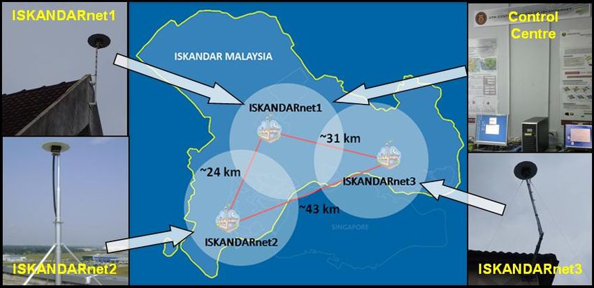
provide real-time data streaming through the Internet and gather data in a control centre for
monitoring and management purpose. Consequently, this requires additional investment in
providing hardware, software and communication links. In addition, it may also need a technical
support and expertise especially to handle such sophisticated real-time system.

Therefore, it is essential to deploy cooperative GPS CORS that may involve various government
agencies, academic institutions, and private sectors. Rizos (2007) has discussed about some
models for the establishment of CORS infrastructure which include various organizations. This
paper generally describe the evolution of cooperative GPS CORS known as ISKANDAR
Malaysia CORS network (ISKANDARnet) that successfully installed by UTM-GNSS and
Geodynamics Research Group, from Universiti Teknologi Malaysia in collaboration with
government sector such as Ministry of Science, Technology and Innovation (MOSTI), Kolej
Komuniti Pasir Gudang (KKPG) and industrial sector such as Port of Tanjung Pelepas (PTP).
Moreover, focus of this paper is addressed to the recent establishment of GPS CORS (i.e. ELS1).
In order to provide high level of GPS data quality, multipath checking has been essentially
conducted. Subsequently, data stream will be illustrated which is intimately related to the
existing ISKANDARnet. The further work of this collaborative CORS then will be discussed. It
is expected that collaboration by various agencies would complement each other and
significantly reducing cost of establishing and operating a CORS service.

2. Overview of ISKANDARnet

The ISKANDARnet has initially established as a research platform and support positioning
activities in the metro-area of Iskandar Malaysia which is the most developed region of
Southern Peninsular Malaysia. The ISKANDARnet comprises of three CORS, namely
ISKANDARnet1 (ISK1), ISKANDARnet2 (ISK2) and ISKANDARnet3 (ISK3), which are
located at UTM, PTP and KKPG, respectively. All CORS stations have been deployed within
inter-station distance about 24 km and up to 43 km to cover the Iskandar metro-area adequately.
Besides that, there is a control centre of ISKANDARnet in UTM, responsible to manage and
monitor the operation of all CORS. Figure 1 shows the overview of ISKANDARnet CORS and
area.

                      Figure 1: Overview of ISKANDARnet CORS and Area.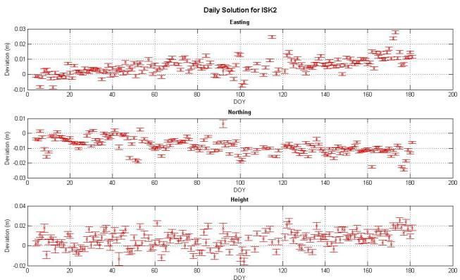
Basically, the key success of ISKANDARnet establishment is highly contributed by the
collaboration of UTM-GNSS and Geodynamics Research Group with various agencies. The
GPS instruments of ISKANDARnet are mainly supported by Faculty of Geoinformation and
Real Estate, UTM by utilizing the existing dual-frequency Trimble 4700 receivers and Trimble
Micro-centred L1/L2 with ground plane (TRM33429.20+GP) antennas. Meanwhile, the rest of
ISKANDARnet establishment and research resource was funded by the MOSTI through a two-
year e-Science project. In addition, the PTP and KKPG have given collaboration in terms of
providing suitable and secure location for CORS. The location is essential to have reliable
source for electrical power and communication link such as internet connection that enables
continuous operation. Besides that, criterion of site accessibility and security must be considered
in order to perform maintenance and protect the equipment against disruption.

2.1 ISKANDARnet CORS Applications

Since the ISKANDARnet CORS has been established, the infrastructure is now routinely being
used to support many applications includes various researches such as below:

2.1.1 N-RTK

The Network-based Real-time kinematic (N-RTK) has been implemented as a research basis
which has collaboration with the UNSW. It ensures that valuable discussion and knowledge
sharing between both the academic institutions (i.e. UTM and UNSW) effectively accomplishes
the primary plan of ISKANDARnet in provision of providing N-RTK service. Test on the
ISKANDARnet N-RTK within coverage area had been conducted in order to verify its
positioning results performance by comparing to existing available national N-RTK system
called Malaysia Real-time Kinematic GNSS Network (i.e. MyRTKnet). Figure 2 show the
position errors for both the N-RTK services; ISKANDARnet (denoted as red) and MyRTKnet
(denoted as cyan) as compared to the known coordinates at PT1, PT2, PT4 and PT7. The
discrepancies in position errors of both N-RTK services in the Northing (dNorth), Easting
(dEast) and Ellipsoidal Height (dUp) components are close to each other and fairly consistent at
the zero or known coordinate‟s value. Furthermore, the average coordinates from both N-RTK
services can also be compared, as the result shown in Figure 3. Overall, both services differ only
in centimetre-level with maximum of 1.7 cm, 1.8 cm and 2.2 cm for the dNorth, dEast and dUp
component, respectively. Hence, the ISKANDARnet positioning results is reasonably
compatible with the MyRTKnet. Further explanation about ISKANDARnet N-RTK can be
found in Shariff (2011).
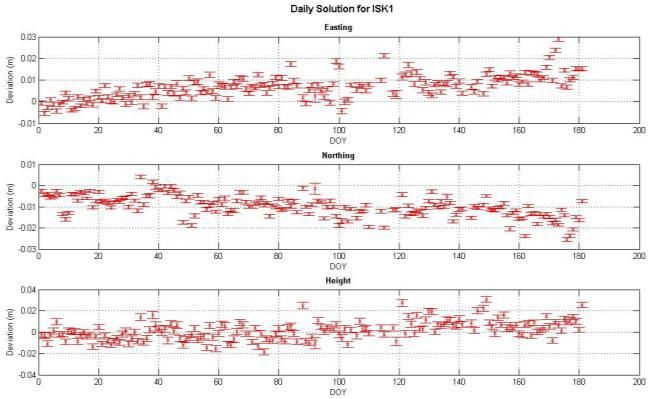
Figure 2: Position errors epoch-by-epoch in dNorth, dEast and dUp components of the ISKANDARnet
(red) and MyRTKnet (cyan) at PT1, PT2, PT4 and PT7.
Figure 3: Position Average for N-RTK of ISKANDARnet Compared with MyRTKnet.
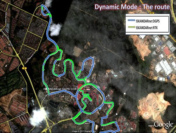
2.1.2 DGPS
The ISKANDARnet CORS is also being used for Differential GPS (DGPS) application. The
ISKANDARnet DGPS has been developed to support real-time operational in most available
condition up to sub-metre level of accuracy. ISKANDARnet DGPS has been investigated by
Wan Aris (2011) in dynamic of the user mode. Figure 4 (a) shows the DGPS integrated
GPS/MSK beacon and Unistrong E650 Real-Time Kinematic (RTK) antennas were mounted on
the car. Figure 4 (b) shows the road path that being used for the experiment. It was found that,
the residuals trajectory between DGPS and RTK only differ by less than 2 m. Moreover, it
reveals that the ISKANDARnet DGPS can perform better in the mode of autonomous „mobile‟
mapping of the road trajectory even though in heavy obstruction which caused the RTK system
frequently loss-locked.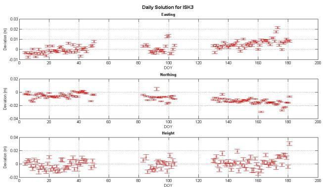
Figure 4: (a) The position of DGPS and RTK antennas on the car, & (b) the route map of UTM, Skudai
  Campus: the blue line on the map shows the car trajectory by using DGPS and the green line by using
                             RTK ISKANDARnet services during the testing.

2.1.3 Ionospheric Study

The investigation on the behaviour ionospheric residuals has been carried out by using CORS
network of ISKANDARnet GPS data. This is the extension of N-RTK study, which equatorial
ionospheric residuals reveals noticeable correlation with geomagnetic storm outburst (Leong et.
al, 2011). Figure 5 shows the geometry-free (L4) residuals on L1 under the Kp-index value of 5
(Kp = 5). The Kp-index value of 5 indicated relatively severe disturbance in the Earth's
magnetic field. It was found that residuals (denotes as red dotes) has the highest values up to 18
cm for lowest elevation satellite (PRN24). The residuals were seen to be affected by the severity
of the geomagnetic storm especially as the elevation satellite getting lower.

 Figure 5: The geometry-free (L4) residuals on L1 under Kp = 5 on August 25th, 2010 for PRN24 from
                              0300-0600 UTC (270000-280800 seconds).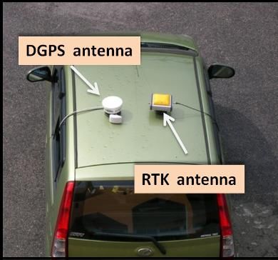
2.1.4 Deformation Study

There is an on-going research on Continuous Displacement Detection System (CDDS) aided by
Real-time IGS stations and ISKANDARnet CORS to support of geo-hazards research platform
in Malaysia. Real-time GPS data from these sites are continuously streamed to CDDS centre
and automatically processed by the Bernese processing engine to detect any displacement. The
CDDS is initially developed by using three ISKANDARnet CORS stations as the object stations.
Preliminary result in the post-processing mode has found that all stations of ISKANDARnet
satisfied a threshold of 15 mm and 25 mm in horizontal and vertical components, respectively
(Yong et. al, 2010). Figure 6 show the daily solution of ISK1, ISK2 and ISK3 stations.
Furthermore, two epoch deformation analysis has been conducted for the ISKANDARnet
CORS (Lim et. al, 2010).

                     Figure 6: Daily Solution of ISK1, ISK2 and ISK3 stations.

2.1.5 GPS Meteorology Study

The ISKANDARnet CORS also has potential to support the GPS meteorology study. The GPS
is a versatile and cost effective tool for the remote sensing of atmospheric water vapour (Musa
et al. 2011). Recently, the ISK1 station has been additionally equipped with weather station that
will dramatically enhances the capability to produce near real-time Integrated Water Vapour
(IWV) and other troposphere products by using data streaming of CORS. It is expected that
online GPS meteorology data processing centre would be able to be developed by participation
and collaboration various interested agencies.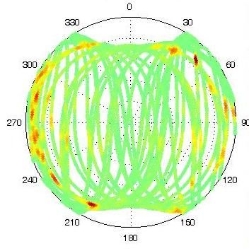
2.2 Current Status of ISKANDARnet Users

The ISKANDARnet currently offers several types of services:
  · GPS RINEX raw data download
  · Single-base Real-Time Kinematic (RTK)
  · Differential GPS (DGPS)
  · Network-RTK based on Virtual Reference Station (VRS)
  · Post-process VRS

All the offered services are presently free of charge and user can register through the
ISKANDARnet website (http://www.geoinfo.utm.my/ISKANDARnet/services.html). The post-
processing service users may download Receiver INdependent EXchange (RINEX) data in daily
and hourly interval. The single-based RTK and DGPS roving users may receive real-time
corrections data transferred from ISKANDARnet server via radio-link and wireless internet. For
N-RTK service, the VRS concept has been implemented in the ISKANDARnet to significantly
enhance precise positioning activities within the coverage area. These VRS data can also be
downloaded by post-processing users as a reference for baseline computation.

Figure 7 shows the types of registered users for ISKANDARnet services that categorized as
students, researcher and industry or private company. It can be realized that majority of the
users are from students category with 92%. It is most probably due to their large community in
UTM and used for academic purposes during their studies. Moreover, the registered user from
researcher group is 6%. However, this group rapidly use ISKANDARnet system because of
continuous or long duration of research. Meanwhile there is 2% of user from industry.

                 Figure 7: Types of Registered Users for ISKANDARnet Services.

Figure 8 shows the cumulative of registered users for ISKANDARnet services from March
2010 until June 2011. The number of registered user has drastically increased on August 2010
prominently due to the increment of student intakes. Generally, the ISKANDARnet registered
user has gradually increased up to 150 users in recent.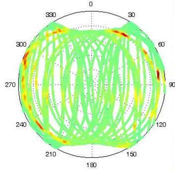
Figure 8: Cumulative Number of Registered Users for ISKANDARnet Services.

3. Establishment of Additional Cooperative CORS

The cooperative CORS namely ELS1 was recently established as extension from the existing
ISKANDARnet CORS. Due to the ELS1 is located at Kepong, Kuala Lumpur, which is about
300 km far from ISKANDARnet area, the ELS1 is only appropriate providing services as a
single reference (i.e. the single-based RTK and post-processing), rather than the N-RTK service.
The N-RTK techniques achieve efficiently in cm-accuracy positioning with inter-reference
receiver spacing of 50-100 km (Rizos and Han 2003). However, the inter-receiver distance even
more limited in Equatorial region due to severe ionospheric activities.

3.1 Multipath Check

In order to establish a CORS, the initial step is conducting multipath check to study the
suitability of the station location. This can be done by two types of analysis which are; (1)
computing the so-called Root Mean Square of multipath on L1 (RMS mp1) and on L2 (RMS
mp2) and (2) polar plot. The “Translation, Editing, and Quality Check” (TEQC) program was
used to derive the RMS mp1 and RMS mp2 values.

Table 1 indicates the RMS mp1 and mp2 values for ten days on 2011, Day of Year (DoY) 170
until 179. It is shows that the RMS mp1 values for ELS1 range from 0.28 m to 0.33 m and the
average is 0.29 m over the ten days. Meanwhile, for RMS mp2, the values are range from 0.30
m to 0.37 m and the average is 0.32 m. These mp1 and mp2 magnitudes are noticeably fairly
acceptable.
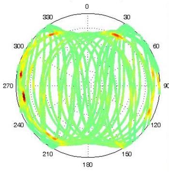
Table 1: Multipath effects on L1 (mp1) and L2 (mp2) at ELS1 CORS.

       Day of Year                      RMS mp1(m)                      RMS mp2(m)
          170                              0.29                            0.33
          171                              0.26                            0.31
          172                              0.26                            0.31
          173                              0.30                            0.33
          174                              0.33                            0.37
          175                              0.30                            0.33
          176                              0.28                            0.31
          177                              0.28                            0.32
          178                              0.27                            0.30
          179                              0.28                            0.32
        Average                            0.29                            0.32

The polar plots of ELS1 have been created by taking 24 hours observation data recorded on
DoY 170, 171, 172 and 173 as shown in Figure 9, 10, 11 and 12 respectively.

     Figure 9: Polar plot of DoY 170                    Figure 10: Polar plot of DoY 171

     Figure 11: Polar plot of DoY 172                      Figure 12: Polar plot of DoY 173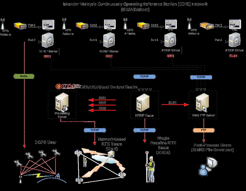
The polar plots significantly aid for interpretation of the multipath effects at the site. Based on
these figures, the azimuth angle (0° to 360°) corresponds to the satellite azimuth, and the black
dashed circle indicates the satellite elevation angle (0° to 90°) from horizontal. The coloured
lines show the path of each satellite during the observation period. The red lines indicate the
expected high multipath effects, where in all azimuth range at elevation angles of about below
than 15° is prone to be affected by multipath. From the site inspection, it was found that the
ELS1 station is surrounded by commercial buildings. Thus, it is suggested that ELS1 CORS to
set the satellite elevation of angle as 15° to maintain the GPS/GNSS data quality. The repetition
of the multipath effects at the same location (in terms of azimuth and elevation angles) can also
be noticed in all four days. It might be caused of the repetition satellite at almost the same path
as stated by Souza and Monico (2004) that multipath errors are similar after a sidereal day.

3.2 The Establishment and Data Transferring of ELS1 CORS

After considering the multipath effects are in the range of acceptable, the installation of
GPS/GNSS Hi-Target VNet6 (AeroAntenna 1675) antenna and setting up the ELS1 CORS was
continued. Figure 13 illustrates (a) the antenna installation work and (b) the current of ELS1
CORS. The antenna is mounted on fixed poles on the rooftops of four-storey building and
cables are tidily carried down and then routed into the building.

In terms of data transferring, the appropriate software and Networked Transport of RTCM via
Internet Protocol (NTRIP) is then applied to enable real-time and continuous data streaming
through Transmission Control Protocol/Internet Protocol (TCP/IP). Thus, the ELS1 CORS is
also equipped with the internet connection. The GPS/GNSS data will be continuously sent to the
control centre which is handled by the NTRIP Caster. The BKG NTRIP Client (BNC) program
then will retrieve the GPS/GNSS from the NTRIP Caster to decode and convert real-time data
into the RINEX file which is stored at the File Transfer Protocol (FTP) ISKANDARnet server.
The FTP server is useful for post-processing user to download the RINEX file. As a backup, the
raw GPS/GNSS data is also recorded at the ELS1 server. Furthermore, the ELS1 provides
single-based RTK service that accessible via internet by specifies the correct IP address as well
as user‟s account name and password in the rover receiver. Overall of data streaming of the
cooperative CORS in ISKANDARnet system can be illustrated in Figure 14.

                              (a)                                   (b)
      Figure 13: Overview of (a) the antenna installation work and (b) the current of ELS1 CORS.
Figure 14: Overall of data streaming of the cooperative CORS in ISKANDARnet system. 4. Concluding Remarks and Future Works This paper has showed that strong collaboration between academic institution and industry, lead to successful of ELS1 CORS establishment. This recent establishment is the expanding of the existing CORS network (i.e. ISKANDARnet) infrastructure that being maintained by UTM. Review on the current status of ISKANDARnet reveal that its services are utilized by various communities and the number of user is significantly increasing. The N-RTK results also show that the ISKANDARnet N-RTK has well performance which is in centimetre-level accuracy. This result also summarizes that N-RTK positioning in ISKANDARnet is compatible with the commercial MyRTKnet system. A comprehensive establishment of ELS1 CORS has been conducted that include the multipath checking to the data streaming. It is realized that the establishment of CORS need the ingenuity of GPS technology integrate with IT to enable the realisation of CORS. In addition, the cost of CORS establishment can be leveraged by the cooperative manner. In order to evolve and upgrade the cooperative CORS in future, a few further works need to be undertaken. A primary concern is that implementing the integrity monitoring to detect malfunction or any outages from the CORS, thus control centre will notify to users. Furthermore, the integrity monitoring for N-RTK can also be done by identifying the network corrections quality in terms of atmospheric residuals. For the case of ELS1 CORS, further test on the single- based RTK will be carried out in order to evaluate the single-based RTK service. In general,
enhancement works in future will bring additional benefits not only for the collaborative
organizations, but also for services subscribers.

Acknowledgements

The authors would like to express their gratitude to Universiti Teknologi Malaysia (UTM) in
supporting throughout this study and to the Department of Survey and Mapping Malaysia
(DSMM) for providing MyRTKnet GPS data. Thankful also addressed to all collaborators in
this study, which are the University of New South Wales (UNSW), Ministry of Science,
Technology and Innovation (MOSTI), Kolej Komuniti Pasir Gudang (KKPG) and Port of
Tanjung Pelepas (PTP).

References

Leong, S. K., Musa, T. A., Omar, K., and Abdullah, K. A., 2010. Ionospheric Residual
       Analysis for Network-RTK in Low-Latitude Area: Towards Solar Cycle 24. Journal of
       Aeronautics, Astronautics and Aviation, Series A, 42, No. 4, 253-258. ISSN 1990-7710.

Lim, M. C., Setan, H. and Othman, R., 2010. GPS Deformation Monitoring and Analysis for
       Local CORS Network: ISKANDARnet. Geoinformation Science Journal, 10, No. 2, 1-
       14.

Rizos, C. and Satirapod, C., 2011. Contribution of GNSS CORS Infrastructure to the Mission of
        Modern Geodesy and Status of GNSS CORS in Thailand. Engineering Journal, 15 (1).

Musa T.A., Amir S., Othman R., Ses S., Omar K., Abdullah K., Lim S., Rizos C. 2011. GPS
       Meteorology in a Low-Latitude Region: Remote Sensing of Atmospheric Water Vapor
       over the Malaysian Peninsula. Journal of Atmospheric and Solar-Terrestrial Physics
       (under reviewed).

Rizos, C., 2007. Alternatives to current GPS-RTK services and some implications for CORS
        infrastructure and operations. GPS Solutions, 11, 151-158.

Shariff, N. S. M., 2011. Development of Network-Based Real-time Kinematic Positioning
         System for Iskandar Malaysia. Master of Science. Universiti Teknologi Malaysia.

Snay, R. A. and Soler, T., 2008. Continuously Operating Reference Station (CORS): History,
       Applications, and Future Enhancements. Journal of Surveying Engineering, DOI:
       10.1061/(ASCE)0733-9453(2008)134:4(95).

Souza, E. M. and Monico, J. F. G., 2004. Wavelet Shrinkage: High Frequency Multipath
        Reduction from GPS Relative Positioning. GPS Solutions, 8, 152-159.

Wan Aris, W. A., 2011. Development of ISKANDARnet DGPS for ISKANDAR Malaysia.
      Master of Science. Universiti Teknologi Malaysia.

Yong, C. Z., Musa, T. A., Othman, R. Omar, K. and Daud, M. E., 2010. The Development of
       Continuous Displacement Detection System in ISKANDAR Malaysia. Journal of
       Aeronautics, Astronautics and Aviation, Series A, 42, No. 4, 241-246. ISSN 1990-7710.
You can also read