Atlas Journal of the Dublin University Geographical Society Volume 17 2019
←
→
Page content transcription
If your browser does not render page correctly, please read the page content below
Atlas

                          Journal of the
         Dublin University Geographical
                               Society

                            Volume 17
                                  2019

              www.facebook.com/DUGeogSoc
  www.tcd.ie/Geography/undergraduate/society.php

 The opinions expressed in this journal are not necessarily those held by the
editing committee. The material published in this journal was reprinted with
  the kind permission of the authors. It remains the property of the original
                               authors © 2019.
Atlas
Volume 17
2019
Correspondence should be addressed to:
DU Geographical Society,
Box 65,
Regent House,
Trinity College Dublin,
Dublin 2,
Ireland
Or
geogsoc@csc.tcd.ieEditorial Committee:
Editor:
Lizzy Gageby Bell
Sub-Editors:
Andrew Duggan Murphy
Ellen Treacy
Cover Design:
Laura Nash
DU Geographical Society Committee 2018/2019:
Honorary President: Dr Cian O’Callaghan
Chairperson: Molly McGrath
Secretary: Megan O’Byrne
Treasurer: Mark McMahon
Public Relations Officer: Laura Nash
Librarian: Lizzy Gageby Bell
1st Year Rep: Edward Meehan
2nd Year Rep: Emily Cantwell-Kelly
3rd Year Rep: Ellen Treacy
4th Year Rep: Eoghan Connolly
Postgraduate Rep: Niall Deegan
Committee Member: Andrew Duggan MurphyContents
Acknowledgements
Lizzy Gageby Bell 5
President’s Foreword
Cian O’Callaghan 7
Chairperson’s Greeting
Molly McGrath 9
A Critical Account of the Representation of Ireland in the
Geography of Strabo and Ptolemy
Maria Cordero 11
Evidence for the First Human Colonisation of the America’s:
A Review
Conor O’Neill 20
Embodiment of Gender Identities in Urban Cycling
A Case Study of Female Students in Trinity College Dublin
Laura Rankin 32
Assessing the Application of Earth Analogs in the Study of
Martian Geomorphology
Keela Conlan 44
Carbon Trading:
A Necessary Solution or a Dangerous Distraction?
Eleanor Scott 52
To What Extent are Smart City Initiatives Sustainable?
Megan O’Byrne 62
A Selection of Photos from the Year 72
4Acknowledgements
The academic journal Atlas was established by the DU Geographical
Society in 1967. Produced intermittently over the years, it has gone
from strength to strength since its 2015 revival. As an homage to the
journal’s roots, Atlas #17’s fantastic retro cover, designed by Laura
Nash, takes its inspiration from a box of old issues discovered in the
Museum Building. Although the journal is no longer sponsored by
Guinness or Shell, other things have remained constant, such as the
brilliance of the TCD Geography students and staff, and the
importance and relevance of the discipline of Geography.
I would like to express my heartfelt thanks to the following
people for their involvement in the production of this year’s journal:
To begin, to all those who submitted their work to Atlas. We received
a huge volume of submissions, and choosing between them was a
difficult task, a testament to the high quality of the work under review.
Next, to my invaluable Editorial Committee: Andrew Duggan
Murphy, a previous editor himself; Ellen Treacy, and Laura Nash.
Sincere thanks also to Cian O’Callaghan and Molly McGrath for
writing the President’s Foreword and Chairperson’s Greeting. I would
like to thank the TCD Association and Trust for their financial
assistance in covering printing costs in full, without which Atlas would
not be possible. Thanks must also go to our wonderful treasurer Mark
McMahon for liaising with the Trust. I would like to express the
gratitude of the society to the Alumni of Trinity College Dublin who
donated to this generous fund.
Finally, on behalf of the Society I would like to extend our
deep gratitude to Gillian Marron, librarian of the Freeman. In
appreciation of all her work over the years we would like to dedicate
Atlas #17 to Gillian.
5It has been a pleasure and a privilege to edit Atlas #17, and I
am extremely proud of the result. It has been a joy to be a part of the
DU Geographical Society throughout my time in TCD, and I would
encourage anyone and everyone to become a member; to quote from
the Atlas of 1972, “It’s worth joining”.
Lizzy Gageby Bell
Head Editor
Atlas #17
6President’s Foreword
2019 is the Year of Geography. This initiative is headed by the
Geographical Society of Ireland, and aims to shine a light on the
diverse work that geographers do and the sophistication of the modern
discipline. While the title is more self-appointed than externally
anointed, it seeks to raise at least two urgent concerns. It aims firstly
to challenge the recent decision by the Irish Government to remove
Geography as a core subject from the Junior Certificate programme,
and secondly seeks to demonstrate the centrality of Geography to
understanding and solving contemporary challenges such as climate
change, global inequality, and increasingly contentious issues like
migration and belonging.
As part of the initiative, geographers working in various fields
took to Twitter using the #IAmAGeographer hashtag to tweet what the
discipline has taught them or how they use Geography in their work.
While the academic responses amply demonstrated how crucial
Geography is in grappling today’s societal challenges, the non-
academic tweets confirmed what those of us who teach the subject
always knew but found hard to adequately articulate: Geography
graduates are everywhere, hidden in plain sight in an amazing array of
jobs and, moreover, they are applying their Geographical skills to excel
in them. Unlike some other vocational courses, Geography does not
prepare us for a particular profession, but helps us to understand our
world. This is something that the members of the DU Geographical
Society know very well. Under the brilliant Chair Molly McGrath – and
supported by a stalwart Committee – the Society has once again
surpassed itself with a stellar set of year-long activities. Geo-Week
focused on Geography and the Sustainable Development Goals, the
International Trip to Sofia included a visit to the Irish Ministry, and the
Flat Earth Ball took a swipe at the virulent trends of ‘Post-truth’ politics
propelling populist leaders to power. In each and every one of their
7endeavours the Society took an approach that was critically-minded,
socially engaged, and entertainment focused; not an easy balance but
one that is effortlessly navigated in the Society’s activities. In this
regard, the Society and its members are the best ambassadors for
Geography that we, as staff, could possibly hope for.
This year was less turbulent – though no less momentous! –
than the last. There were no big cabinet reshuffles. Despite the
turbulence of ongoing TEP reshuffling, Molly and the rest of the crew
kept an even keel on the Society ship. I remain always impressed by
the organisation and dedication of the Committee. Thank you to Molly,
Megan, Mark, Laura, Lizzy, Niall, Eoghan, Ellen, Emily, Edward and
Andrew for making my (however small) job as Honorary President an
extremely pleasurably one. This year I did manage to gather a staff,
postdoc and postgrad team for the table quiz, following my very poor
showing in 2017, so I’ll call that a personal win.
As a document and milestone for the Society’s ethos and
activities, Atlas reflects the serious scholarly and critical engagement
with Geographical thought that underpins everything the Society does.
In the spirit of the Year of Geography, the selected articles in the 2019
edition grapple with gender identity, colonialism, carbon trading, and
Martian geomorphology among other topics. Geography, the ultimate
synthesis discipline, is the only one that could hold these topics
together. Special thanks and recognition to Lizzy Gageby Bell, who
edited this year’s edition, for aptly demonstrating this in her editorial
choices. In a world characterised by growing uncertainty and division,
Geography is more important than ever to understand the root causes
and respond in effective ways. Some of the answers are in here, this the
17th volume of Atlas. What are you waiting for?
Cian O'Callaghan
Honorary President
8Chairperson’s Greeting
Welcome to the Dublin University Geographical Society’s annual
publication of Atlas! I am extremely grateful to the editorial committee:
Lizzy Gageby Bell, Andrew Duggan Murphy, Ellen Treacy and Laura
Nash, for overseeing the society’s long-established publication for this
year. I would like to thank all those who took the time to submit their
essays and I want to congratulate all the authors whose work has been
included in this year’s edition of Atlas. I would like to extend my
appreciation and gratitude to the Alumni office, without whom Atlas
would not be possible.
It has been my true honour and pleasure to have been elected
as the Chairperson of the Dublin University Geographical Society for
its 59th year. The main focus I had for the society this year was
inclusion and communication among the committee, and particularly
within the geography department. I wanted to encourage engagement
so that everyone had the opportunity to attend our events, trips, meet
new people and make lifelong friendships, which I believe is a core
aspect of the society. I am truly grateful to have met so many people
and have been able to attend such fantastic events thanks to the society
over the last four years.
I have enjoyed every aspect the role of chairperson entailed.
Organising and overseeing events, such as our unforgettable
international trip to Sofia, Bulgaria. Our biggest and most successful
Christmas pub-quiz, with the room exceeding capacity! The beloved
Bingeo. Our first mystery tour and the society’s largest national trip, as
forty-two members got to experience the wild shores of Bundoran,
Donegal. Finally, the annual society ball, this year named [flat] Earth
Ball, was a massive success and a thoroughly enjoyable night.
The society had a truly successful and ground-breaking year
and that is thanks to this year’s hard-working committee. Our year reps:
Ed, Emily, Ellen, Eoghan and Niall. Our OCM: Andrew.
9Our librarian, Lizzy. The extremely talented Laura, our PRO.
Particularly, the secretary Megan and the treasurer Mark who helped
me endlessly. Thank you all for being so generous with your time in
order to ensure the continued success of the society in its 59th year. It
has been a privilege to have been chair this year and getting to work
with you all.
Our honorary president this year was Dr Cian O’Callaghan. I
am indebted to him for the time he so generously gave to help the
committee and promote the society to his classes, which has been
invaluable to the society this year and has contributed to its success.
I hope you enjoy the latest edition of Atlas. My hope is that you
all had an enjoyable and memorable year with GeogSoc. I look forward
to seeing the future of GeogSoc and the continued successes of this
wonderful society!
Ní neart go cur le chéile!
Molly_McGrath
Chairperson
Dublin University Geographical Society
2018/2019
10A Critical Account of the Representation of Ireland in the
Geography of Strabo and Ptolemy
Maria Cordero
Introduction
Little is known about Irish history before the fifth century AD. Two
of our best surviving sources of information regarding our past are the
classical geographers Strabo and Ptolemy. While their work may not
be entirely accurate, it still holds a great deal of value for modern day
readers. As will be discussed below, their work sheds light not only on
our country’s history but also the history of ancient Rome and the
history of the study of geography itself.
Ptolemy
Maps tell us so much more than how to get from A to B, or
where C is in relation to D. They can be tools of power and
snapshots of history, and reveal the fears and prejudices of
their age – Jerry Brotton (2010)
Claudius Ptolemy was an ancient Roman who was thought to have
lived c. 100 AD. He was a “Renaissance man” of sorts, as was
common at the time, dealing with all manners of mathematics,
astronomy, astrology and of course geography. He wrote three major
works in his lifetime: the Almagest (an astronomical work), the
Geography, and the Tetrabiblos. In the context of Ireland, his
Geography, in which he was attempting to give a description of the
known Greco-Roman world, is the most crucial.
Ptolemy’s work is heralded for its remarkable accuracy in
determining latitude and longitude, which he accomplished by
measuring the longest hours of daylight and length of astronomical
events respectively. He also incorporated many data from secondary
sources such as merchants and military figures, and it is well
established that much of this work is built upon that of Marinus of
Tyre. A more critical attitude to Ptolemy’s work, such as that of
Tierney (1976:264) would attest to the fact that his work is more of a
cartographic effort than a geographical one, as it leaves out much of
the qualitative, ethnographic information that Marinus of Tyre is
11thought to have provided.
Neither Ptolemy nor Marinus themselves ever travelled to
Ireland, which serves to explain many of the inaccuracies in their
work. Even Philemon, who Marinus is thought to have been largely
influenced by, likely never travelled to the island (Toner, 2000:73).
Tierney (1976:257) attests that most river and tribal names recorded
by Ptolemy come from Philemon. It is therefore not surprising that
much of their writings may be less than accurate. O’Rahilly (1946:41)
suggested that Ptolemy may have gotten some of his information from
Pytheas of Massalia, however this theory was largely disproven by
Tierney (1976:265) amongst others.
As a result, much of the data in his work, particularly the
names of places and rivers (covering 15 rivers, 6 promontories, 10
cities and 16 tribes) were received from merchants who had travelled
to Ireland. This source of information had two major issues: travellers
were likely not familiar with the country in its entirety (which may
explain why Ptolemy gives a more accurate description of Ireland’s
East Coast than its West) and they for the most part spoke no Irish.
Mac an Bhaird (1991-93: 1-2) writes strongly that almost no foreign
scribes had any success in reproducing Irish names correctly.
Much ink has been spilled by scholars attempting to match
Ptolemy’s named cities to their contemporary equivalents. Many of
these attempts to find matches use the etymology of the names and
their possible similarities to Irish place-names. It was pointed out by
Orpen (1894:116) however that using this “resemblance of sound”
between Ptolemy’s names and the modern Irish language is not
reliable. Anyone with a knowledge of the country's history will know
that the language of Irish, as well as the names of our cities, have
changed dramatically in the intervening centuries. Toner (2000:78)
applies the same critique to work on tribal names, as almost all tribes
would have disappeared or become irrelevant before the next works
were written on Ireland.
Raftery (1994:206) attributes the fact that many of the place
names have been apparently “British-ised” to the fact that British
merchants likely just miscommunicated names heard from natives.
Further mistakes were very likely introduced as the work itself was
then copied into Greek and later into Latin around the fifteenth
12century. Another noted issue with using merchants as a source is that
many locations which Ptolemy recorded as towns were likely just
places of assembly (MacNeill 1919:138), which is believed to be the
case for Ptolemy’s city ‘Manapia’, located in South Leinster. Despite
its flaws, Ptolemy’s map does provide some confirmation around the
prehistoric division of Ireland into five parts, which was noted in pre-
Patrician works (Darcey and Flynn 2008:61).
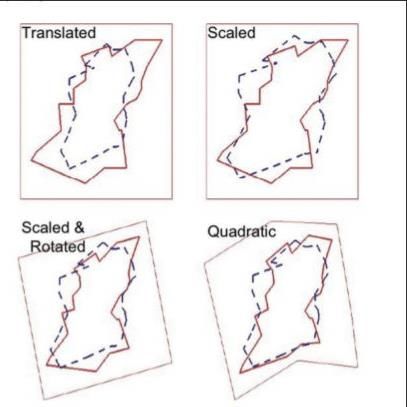
Figure 1: One example of a
mathematical approach to
interpreting Ptolemy:
Mintz’s four mathematical
translations attempting to
shift Ptolemy’s map towards
its most accurate modern
equivalent.
(Mintz, 2009:7)
Ptolemy’s work didn’t merely consist of lists of place names
however, and much of the commentary on his work is surrounding his
measurements and cartography. Scholars writing about Ptolemy’s
Ireland are quick to point out that he has placed Ireland about 5° too
far North (Thomson 1948:21). Academics such as Darcey and Flynn
(2008:49-69) have reviewed his work mathematically, calculating the
error in his figures and performing transformations on his imperfect
“map” (out of interest, Darcey and Flynn estimate his longitudinal
error to be about 15° and 1⁄3° error in latitude). The criticism of this
line of research is that (thanks to modern science) we are now well
informed on the dimensions of Ireland. Toner (2000:74) went as far as
to say that speculation around Ptolemy’s Geography “does not help to
refine our knowledge of Ireland or Ptolemy”. What, then, is the
relevance behind studying his work at all?
Ptolemy’s efforts to describe Ireland first of all tell us that
Ireland was somewhat relevant to the Ancient Greeks and Romans.
13Although we have some record of Ireland having traded with Ancient
Rome, Ptolemy’s work gives us details of such trade (even if he did so
unknowingly). For example, his work outlines that it takes 20 days to
travel from the East to the West of the island, indicating that at least
some merchants travelled the inner island and as well as the coasts
(Freeman 2001:67).
In a broader sense, we use his work to more generally critique
the idea of maps as ideal, objective sources. Ptolemy’s methods of data
collection and measurement may seem inaccurate at best to a modern
geographer, but they can shed light on just how geography was done
at the time. Just as a future historian may look at a modern map and
see a reflection of our political climate (for example the central
placement of Europe on most maps), so too can we look at Ptolemy’s
map and learn about the capabilities, opinions
and_motives_of_ancient_Rome.
Strabo
The myth that ethnographers are people without personal
identity, historical location and personality, and would all
produce the same findings in the same setting, is the mistake
of naïve realism. –Brewer (2000:99)
Strabo predates Ptolemy by about 100 years, and was alive during the
transition from the Roman Republic to the Roman Empire. While he
did famously travel much of the known world (the oikumene), he was
similar to Ptolemy in that he never visited Ireland personally. As a
result, his writings on the country are also flawed. As noted by
Pothecary (2015) in relation to his work in Roman Asia, his work was
largely written in his later life and even in regards to the places he did
visit he likely forgot many details by the time he recorded his travels.
His work differs in that it is a largely ethnographic description rather
than a quantitative one, and therefore is also susceptible to much
criticism.
It is a general criticism of Strabo’s work that he seems to view
the world through a very binary lens; seeing people as either civilised
or uncivilised, or as Roman or un-Roman (Van der Vliet, 2003:257).
This dichotomization leads him to often skew his findings to fit this
preconceived worldview. A related dimension to take into account
14when viewing his work is that Strabo wrote with a clear audience in
mind; the Roman army. It was strictly a strategic work, like much of
the geography after him, designed to assist in the colonisation of the
world by imperial powers.
It is not surprising then that he did not write extensively on
Ireland (Ierne) as he says himself of the region that “for governmental
purposes there would be no advantage in knowing such countries and
their inhabitants... They can neither injure nor benefit us in any way
because of their isolation.” (Strabo, 1923:447). Perhaps many
Irishmen would have been content with Strabo having not written
about Ireland at all, as what he does write is less than flattering.
Strabo’s description of the Irish people portrays – in only a
short passage – accounts of both cannibalism and incest (Strabo,
1923:259). This was not the first description of its kind, with Diodorus
Siculus (V, 32) also writing about the cannibalism and savagery of
Irish people. It is likely therefore that Strabo was either influenced by
this work directly or that this was a common idea of Ireland at the time.
It is worth noting that during the period in which Strabo’s Geography
was written (c. 7 BC), Ireland was almost certainly trading with Rome,
as artifacts such as those found in the ‘Broighter Hoard’ found in
Northern Ireland date back to around this period (Laing, 2005). We
can therefore say with some confidence that Strabo’s depiction of the
Irish people as complete savages is not entirely accurate.
Figure 2: Broighter
Gold Boat, Dublin,
October 2010.
Commonly dated to
approximately the same
time as Strabo’s
Geography was written
(Wikimedia Commons)
Strabo does add a
disclaimer to his
comments that he was “saying this only with the understanding that
(he has) no trustworthy witnesses for it” (Strabo, 1923:259). Strabo
15makes a similar assertion at the preface of the Geography to the effect
that minor errors in the book should be ignored in respect to the
breadth of the subjects that he has covered. In this sense, we can
imagine that Strabo did not see Ireland as a place of very much
relevance, and was therefore not hugely concerned with an accurate
portrayal. Tierney (1976:260) suggests that this disclaimer was
influenced by, if not taken from, the previous writer Pytheas, who
made a point of distinguishing between his first-hand knowledge and
“hearsay”.
Figure 3: Depiction of Irish
‘atrocities’ during the Rebellion of
1641 by Wenceslaus Hollar,
showing a similar rhetoric to that
of Strabo towards Ireland
(Wikimedia Commons)
It is entirely possible however that Strabo’s less-than-
flattering description of Ireland was more than just an oversight, and
was in fact part of a wider belief system he held regarding the
“civilised” world. One glaring mistake of Strabo’s was placing Ireland
some 800 km above Britain, despite the fact that he was familiar with
Caesar's previous work which contradicts this (Freeman 2001:39). In
doing this, many believe Strabo was bolstering an argument that the
island Ierne was the edge of the civilised world; an argument that is
further strengthened by the image of the Irish people as almost
complete animals. This is not unprecedented for Strabo, for example
he condemns the “barbarian” people of Caucasus for taking new wives
after having had children with previous ones, despite this being a
practise in his Rome (Van der Vliet, 2003:268).
There is also a distinct “deterministic” tone to Strabo’s writing
about the Irish, claiming that it “is such a wretched place to live in on
account of the cold” (Strabo, 1923:271). This fits into the worldview
of civilisation going through a sort of outward evolution, with warm
16Rome at the centre and the farthest stretches of the known world
playing host to the most barbaric of people (Van der Vliet, 2013:259).
This viewpoint was certainly not unique to the classical world
however, and perpetuated right through to the twentieth century if not
to the present day. One such example is the work of Ellsworth
Huntington in 1915 that attempted to assert the racial superiority of
Europe and North America over other continents due to their more
favourable climates. It is of course unclear whether this rhetoric stems
directly from the work of Strabo, but there is a clear comparison to be
drawn between his work and that of later imperialists.
Strabo’s work is thought to have directly affected that of much
of Renaissance Italy in a more tangible sense. Haywood (1996:467-
486) contests that the rediscovery of Strabo’s work in the Renaissance
period may have contributed to the general distaste for Ireland at that
time (it had been viewed relatively positively up to that point in the
late medieval period). Strabo’s Rome-centric view of the world may
have resonated with Renaissance Italian geographers, who found it
similarly convenient to portray Ireland as an uncivilised country
serving “the purpose of shielding Europe
from_the_Beyond”_(Haywood_1996:_479).
Conclusion
Studying what ancient writers have documented about something we
know ourselves with great familiarity can seem a thankless task; what
is the value in trying to determine where Ptolemy’s Irish rivers were
located if we can consult any modern map to know any precise
coordinates? The search for meaning in these works goes beyond the
literal features that they were describing and delves more into what
they saw as the function of their “Geographies”.
The fact that Ptolemy recorded in remarkable detail the
topography and location of Ireland shows that it was a place of
relevance to him and gives us a clear record of merchants having
travelled to our shores. Strabo’s depiction of Ireland as a barbaric land
that was just about regarded as habitable gives us a wealth of
knowledge about how the Romans at the time viewed themselves and
the rest of the world. Both works draw the attention of the modern
geographer attempting to quantify exactly what the study “geography”
17is, and what purpose it serves. Overall, their combined work on Ireland
may in fact serve as a mirror, and shed more light on them and their
world than it does on ours.
Bibliography:
Brewer, J. (2000). Ethnography. McGraw-Hill Education (UK)
Darcy, R. and Flynn, W. (2008). Ptolemy's map of Ireland: a
modern decoding. Irish Geography, 41(1), pp.49-69.
Brotton, J. (2010). ‘Why a Map is a Window on to History’ (online).
BBC News Magazine.
Diodorus Siculus. (1933). Library of History, Volume I: Books 1-2.34.
Translated by C. H. Oldfather. Loeb Classical Library 279.
Cambridge, MA: Harvard University Press.
Freeman, P. (2001). Ireland and the classical world. Austin: University
of Texas Press.
Haywood, E. (1996). ‘Is Ireland worth bothering about? Classical
perceptions of Ireland revisited in Renaissance Italy’.
International Journal of the Classical Tradition, 2(4), pp.467-
486.
Laing, L. (2005). ‘The Roman Origins of Celtic Christian Art.’
Archaeological Journal, 162(1), pp.146-176.
Pothecary, S. (2016). ‘A Road Trip with Strabo’. Mnemosyne, 69(2),
pp.202-225.
Tierney, J. (1976). ‘The Greek Geographic Tradition and Ptolemy's
Evidence for Irish Geography.’ Proceedings of the Royal Irish
Academy: Archaeology, Culture, History, Literature, 76,
pp.257-265.
Toner, G. (2000). ‘Identifying Ptolemy's Irish places and tribes.’ In:
D. PARSONS AND P. SIMS-WILLIAMS, ed., Ptolemy:
towards a linguistic atlas of the earliest Celtic place-names of
Europe. Aberystwyth: CMCS Publications, pp.73-82.
Van Der Vliet, E. (2003). ‘The Romans and Us: Strabo’s Geography
and the Construction of Ethnicity.’ Mnemosyne, 56(3),
pp.257-272.
Huntington, E. (1915). Civilisation and Climate. Yale University
Press.
18Leonard Jones, H. (1923, 2006 Reprint). Strabo, Geography. pp, 258-
261
Mac An Bhaird, A. (1991,1993). ‘Ptolemy revisited’, Bulletin of the
Ulter Place-Name Society. pp. 1-20
Macneill, E. (1919). Phases of Irish history. Dublin: M.H. Gill & Son
Mintz, D. (2009). The hunt for the lost cities of Ptolemy. Taylor and
Francis group
O’Rahilly, T.F. (1946). Early Irish history and mythology. Dublin:
Dublin Institute of Advanced Studies
Orpen, G. H. (1894). ‘Ptolemy’s Map of Ireland.’ Journal of the Royal
Society of Antiquaries of Ireland, Fifth series, pp. 115-128
Raftery, B. (1994). Pagan Celtic Ireland: the Enigma of the Irish Iron
Age. London.
Thomson, J.O. (1948). History of Ancient Geography. Cambridge:
Cambridge University Press
19Evidence for the First Human Colonisation of the
Americas: A Review
Conor O’Neill
Introduction
The early Human colonisation of the Americas is an extremely vibrant
and contested area of palaeoanthropology. While there is general
agreement that the first people entered the Americas via a land bridge
between Siberia and Alaska known as Beringia, the question of when
that occurred and what routes were taken from there is highly
contested.
The classical theory of early human colonisation of the
Americas for much of the last century centred on the Clovis people.
An ice-free corridor between the Laurentide and Cordilleran ice sheets
in Canada provided the route for small groups of humans using stone
tools to travel southward into the modern-day United States. This was
thought to have occurred around 11,000 cal yr BP (Waters and
Stafford Jr, 2007). These first humans developed the distinctive Clovis
tools which have been found and dated securely at a number of sites,
mostly in North America and some in Central America (Waters and
Stafford Jr, 2007).
However, more recent improvements in radiometric dating,
environmental reconstructions, and genomic data mean that the
‘Clovis First’ paradigm has been increasingly questioned, to the point
where it is now almost entirely abandoned in favour of earlier
colonisation dates (Erlandson, 2013; Halligan et al, 2016). This essay
will examine the new theories which have emerged, especially the
coastal migration versus inland corridor theory, and the most up-to-
date genetic evidence for the timing of the first humans in the
Americas. It will also examine whether humans populated the
Americas in one wave, or in multiple migrations.
20Clovis First
Sites containing Clovis artefacts, typically distinctive stone tools, are
widespread around the contiguous United States. The first appearance
of Clovis sites across America has been dated to around 11,000 cal yr
BP (Waters and Stafford Jr, 2007). Generally accepted during the 20th
Century as the first humans in America, there have since been further
site discoveries in North and South America which are earlier than the
radiocarbon Clovis dates. An example is the Page-Ladson site in
Florida (Halligan et al, 2016). Page-Ladson is a submerged river site
containing late Quaternary sediments; within these sediments are
wood samples, stone flakes, and biface tools (Halligan et al, 2016). As
the wood and tools were contained in the same secure stratigraphy, a
radiocarbon date on the wood samples could be used to date the stone
tools. Dates from the biface tool and other artefacts give a range of
about 14,550 to 14,200 cal yr BP (Halligan et al, 2016), much earlier
than the Clovis dates put forward by Waters and Stafford Jr (2007).
Possibly the most well-known pre-Clovis site is Monte Verde in Chile.
This site contains definite artefacts, such as flakes, projectile points,
and bifacial pebble tools (Dillehay et al, 2015) which have been dated
to about 18,500 to 14,500 cal yr BP, and is widely accepted as
evidence of early human occupation which pre-dates Clovis
technology (Goebel et al, 2008).
As these examples show, Clovis humans were not the first
colonisers of the Americas. The findings above show that humans
were in America earlier than was thought during much of the 20 th
century. This brought into question the ice-free corridor that was
thought to have provided the route south.
While the opening of the ice-free corridor in Western Canada
occurred around 15-14,000 cal yr BP, this does not mean that the route
represented a viable migration option for humans at that time.
21Pedersen et al (2016) analysed lithological and biological change in
sediment cores from Glacial Lake Peace, a proglacial lake which
existed in the corridor during glacial retreat. By examining pollen
grains and environmental DNA in the sediments, they were able to
reconstruct the environment of the ice-free corridor as it first opened
up. They found that the corridor opened on its northern and southern
ends initially, with a central section the last to clear. Vegetation had
spread by about 12,600 cal yr BP, with animals of various sizes
moving in about 100 hundred years after that (Pedersen et al, 2016). It
was only from this point (about 12,500 cal yr BP) that the corridor
represented a viable option for humans to travel through.
This means that the humans occupying sites such as Page-
Ladson and Monte Verde cannot have travelled through the interior
route. Furthermore, the corridor was also not viable before the
appearance of Clovis. It has thus been suggested that a Pacific coast
route may have been used instead by early humans entering America.
Coastal versus interior
With the discovery of pre-Clovis human occupation sites, questions of
both when the first humans entered America and by what route have
intensified. The possibility of a coastal route has become more
mainstream recently (e.g. Llamas et al, 2016; Erlandson, 2013).
While the ice-free corridor theory was the main route put
forward for human migration southwards for much of the 20th century
(Waters and Stafford, 2007), its viability as a route has been
questioned recently. Already mentioned above is the fact that human
sites which pre-date the opening of the ice-free corridor have been
found south of the ice sheets (Pedersen et al, 2016). Beyond that, the
harsh conditions within the corridor have been described as unsuited
to supporting a human migration. Dixon (2013) notes that for a long
time the corridor was biotically impoverished, with large proglacial
22lakes and boggy terrain acting as barriers to any colonizing species. It
has also been suggested that, for a number of environmental reasons,
it was more favourable for southern species to move north through the
corridor, rather than northern species to move south (Dixon, 2013).
Not all recent literature on the ice-free corridor has been
negative. Potter et al (2017) suggested that the analyses by Pedersen
et al (2016) and others were premature in their criticism of the
corridor. For instance, they say that wood recovered from the base of
lake sediments in Boone Lake, near Glacial Lake Peace, dated to about
13,555 cal yr BP is evidence of forestation in the corridor at least 1000
years earlier than Pedersen et al (2016) proposed. They also claimed
that populations which had been living in Beringia for an extended
period would be quite adapted to harsh conditions in the ice-free
corridor, and suggest that it was viable by 14-13,000 cal yr BP.
However, the finding of wood in the lake is not entirely convincing as
it does not prove that the route was viable. It is a very long corridor,
and humans travelling through it would need a plentiful supply of food
and fresh water to survive the journey.
Erlandson (2013) proposed that a coastal route south from
Alaska may have been used, due to certain advantages provided by
such a route. Part of the basis for this is that it represents a relatively
linear route with no major geographic obstacles. As it is mostly at sea
level, it doesn’t require the crossing of mountain ranges, which
provide both a time and climatic barrier. It also gives access to
productive coastal habitats, which offer abundant marine species as
food (Erlandson et al, 2015). These coastal habitats were also possibly
similar to Beringian habitats, meaning they required less adaptation
than an inland route along the ice-free corridor (Erlandson et al, 2015).
The Northwestern coast of America was likely de-glaciated in
many parts by about 16,000 cal BP (Dixon, 2013), providing a route
for humans to move along the coast. One major issue with the coastal
route theory is the lack of sites containing human evidence dated prior
23to about 13,000 to 12,500 years ago (Dixon, 2013). While sites on the
coastal regions of the Americas have been dated to around the same
time as Clovis sites (Erlandson et al, 2008), the lack of fossil and lithic
evidence clearly predating them means that determining which route
was taken is difficult. The southern coast of Beringia is one area that
has a particular lack of archaeological sites dating from this time
(Potter et al, 2017); if the coastal route was used, one would expect to
find human sites from this time along it. Instead, the oldest human
occupation sites are in the interior, such as the Bluefish Caves dating
to 24 thousand years ago (ka) (Bourgeon et al, 2017). One point made
by a number of authors is that sea level has risen considerably, by
about 100-120m (Dixon, 2013), since the time of deglaciation. This
has potentially inundated sites containing evidence of the earliest
human presence on the American Pacific coast (Dixon, 2013;
Erlandson, 2013). However, Erlandson (2013) points out that the
Pacific coast of America generally has quite a steep continental shelf,
meaning the effects of sea level rise have likely not been as sharp as
on the Atlantic coast. This seems quite a sweeping statement, so it
should be treated with caution. Nevertheless, the lack of human fossil
and lithic evidence on the Pacific coast is problematic.
Fossil and lithic evidence alone will probably not be sufficient
to determine which route the first humans took when moving into the
Americas. Fortunately, advances in genetic reconstructions which are
discussed below have led to better understanding.
Genetic evidence
Genetic evidence can be used to further the understanding of two key
areas; the timing of the arrival of humans into the Americas, and
whether America was populated by a single wave or multiple waves
in succession. An examination of mitochondrial DNA (mtDNA) and
Y chromosomes has shown that, in modern Native Americans, there
24are five mtDNA founding haplogroups and two Y chromosome
haplogroups (O’Rourke and Raff, 2010). All of these haplogroups are
also found in native populations of Siberia, whereas only one (X) is
found in Europe or central Asia (Goebel et al, 2008). Work on ancient
Native American DNA gives the same results (Goebel et al, 2008);
combining the ancient and modern DNA shows that the first humans
into America originated from Siberia, an assertion that is also made by
Llamas et al (2016). The separation from Siberian humans most likely
occurred during the Last Glacial Maximum (LGM). An estimated date
range for when this divergence occurred was worked out by examining
gene flow to be between 24.9 and 18.4 ka (Llamas et al, 2016). Llamas
et al (2016) were able to calculate this by sequencing the
mitochondrial genome from 92 pre-Columbian skeletons which
ranged in age from 8.6 to 0.5 ka.
The estimate from Llamas et al (2016) for the separation of
Siberian and Native American ancestral populations (24.9 to 18.4 ka)
is concurrent with the LGM. As the LGM saw massive expansion of
ice sheets along the coast and interior of Canada, the population
present there at that time were likely trapped and used Beringia as a
refugium (Llamas et al, 2016). Again, genetics were used to support
this; while the lineage shows very little diversity for thousands of years
(while the population was constrained geographically and thus small
in size), it shows a sudden increase in diversification starting around
16 ka (Llamas et al, 2016). This coincided with an increase in effective
female population, and Llamas et al (2016) state that the population
increased by a factor of 60 between 16 and 13 ka. Hence, they suggest
16 ka is the likely time of first entry southwards into the Americas
following the isolation period in Beringia. The findings on the
population bottleneck and Beringian standstill period, preceding
expansion around 16 ka, were also put forward by Skoglund and Reich
(2016).
The Beringian standstill hypothesis, which above has been put
25forward by genomic evidence, has also been advanced by
archaeological evidence. The Bluefish Caves, in the Yukon in Canada
and very close to the Alaska border, contain numerous mammal bones
which have been accurately radiocarbon dated (Bourgeon et al, 2017)
and calibrated to as early as 24,000 cal yr BP. Cut marks on the bones
have been associated with humans and the Bluefish Caves are
currently thought to have been used as a short-term hunting site. This
find is currently the oldest archaeological site in North America
(Bourgeon et al, 2017). The combination of this archaeological
evidence with the genomic evidence above lends significant support
to human presence in Beringia and the Beringian standstill period.
This timing supports the coastal entry route theory mentioned
above. The population explosion began around 16 ka (Llamas et al,
2016), predating the viability of the ice-free corridor, whether the
dates from Pedersen et al (2016) or from Potter et al (2017) are taken
to be accurate. It seems plausible that an expansion into newly opened
territory, with abundant marine and terrestrial life, and space to
expand, would have resulted in this population explosion. This lines
up well with the deglaciation of much of the coastal route by 16 ka
(Dixon, 2013).
One other point of contention is whether the Americas were
populated by a single wave of migration, or by multiple groups. Reich
et al (2012) examined data from Native American and Siberian
genotypes, sampled from DNA collected over several decades. Their
findings showed that the vast majority of Native American populations
(pre-1492) across the Americas derive ancestry from a single ancestral
population, which they estimate crossed through Beringia at least 15
ka. They also found that two separate gene flows from Asia into North
America were present, indicating later migrations which gave rise to
Eskimo-Aleut and Chipewyan populations in the Arctic and northern
Canada (Reich et al, 2012). These gene flows are not present in Central
and South American populations; these groups fit in with a single
26founding population (Skoglund and Reich, 2016). An examination of
autosomal DNA identified an allele present in Native American
genomic structure that is extremely rare in potential Asian sources;
this was used as further evidence for a single founding population
(Skoglund and Reich, 2016). A maximum upward limit on this
migration was around 23 ka, with this single population then
diversifying around 13 ka when population expanded again
(Raghavan_et_al,_2015).
Another possibility?
All human remains found in the Americas to date are of anatomically
modern Homo sapiens. A possible exception is a discovery in
California known as the Cerutti Mastodon site (Holen et al, 2017).
Holen et al (2017) presented evidence consisting of apparent stone
tools and fragmentary remains of a mastodon, but no human skeletal
remains. They interpreted marks on the bones and tools as evidence of
the presence of a species of Homo. As the site was dated via
radiometric dating to about 130,000 ya, this would have meant that it
was an earlier species of Homo, rather than Homo sapiens (Holen et
al, 2017). This has been questioned critically by other researchers.
Ferraro et al (2018) noted the absence of any debitage, the distinctive
debris and leftovers of lithic tool production that are common at other
hominin sites. They also claimed that the marks on the mastodon
bones were not indicative of hominins (Ferraro et al, 2018). Haynes
(p. 197, 2017) noted serious problems with the lack of “deliberately
shaped lithic tools and cultural features”, with the only objects present
the previously mentioned mastodon bones and broken cobbles.
Despite replies to these by the original authors (Holen et al, 2018a;
Holen et al, 2018b), the evidence for human presence at the Cerutti
Mastodon site is suspect. The assertion by Haynes (2017) that the
cobbles at the site do not represent clear evidence of lithic tools,
combined with the lack of characteristic debitage, are important. The
27extremely early date is over 100,000 years before any other evidence
of humans in the Americas. As this would radically change the subject,
robust data is required to make a conclusion. The evidence presented
by Holen et al (2017), while interesting, is not enough to prove the
presence of Homo in the Americas at 130 ka; further research is
needed. Critically, human skeletal remains would drastically change
the situation; when lithic evidence is combined with primary human
skeletal remains, more robust_conclusions_can_be_drawn.
Conclusion
The early human occupation of the Americas is clearly a very active
research area. With the discovery of pre-Clovis sites like Page-Ladson
in Florida and Monte Verde in Chile, the topic has experienced an
upheaval recently. From the evidence presented here, it appears that
the first Americans entered the land bridge known as Beringia around
24.9 to 18 ka, where they were then isolated from Asian populations.
It appears that this population were then isolated in Beringia for an
extended period of around 2000 years, known as the Beringian
standstill. This has been suggested mostly by genomic evidence which
points to a population bottleneck and low genomic diversity. However,
the Bluefish Caves finding, when combined with the genomic
evidence, means that the evidence for human presence at that time is
quite robust.
Genomic diversification ramps up around 16 ka, and is
associated with a rapid expansion in population. As this occurs around
the same time as deglaciation on the Pacific Northwest, and the ice-
free corridor in the interior remains unviable at least for another few
thousand years, it appears that the population in Beringia began to
expand southwards around 16 ka via the coast. While Potter et al
(2017) claim that the widespread acceptance of the coastal route is
premature, it seems from genomic and paleogeographic evidence to be
28the most likely route. Where it falls down slightly is in physical
evidence of human presence. Erlandson (2013) makes the strong point
that archaeological evidence needs to be combined with genomic data
in order to make any strong arguments in this area. Until this happens,
the coastal versus interior debate will continue.
Finally, genomic investigations point strongly towards a
single population leading to the settlement of the Americas, followed
some time later by small migrations into the Arctic and northern
Canada. The arguments for the first settlement of the Americas are
strongest when multiple forms of evidence are effectively combined;
effective use of archaeological sites, genomic data, and
paleogeographic reconstructions lead to the most robust and credible
explanations.
Bibliography:
Dillehay, T.D., Ocampo, C., Saavedra, J., Sawakuchi, A.O., Vega,
R.M., Pino, M., Dix, G. (2015) ‘New Archaeological
Evidence for an Early Human Presence at Monte Verde,
Chile’, PLoS ONE, vol. 10 (11) e0141923
Dixon, E.J. (2013) ‘Late Pleistocene colonization of North America
from Northeast Asia: New insights from large-scale
paleogeographic reconstructions’, Quaternary International,
vol. 285 pp. 57-67
Erlandson, J.M. (2013) ‘After Clovis-First Collapsed: Reimagining
the Peopling of the Americas’. In: Graf, K.E., Ketron, C.V.
and Waters, M.R. (eds.) Paleoamerican Odyssey, College
Station: Center for the Study of the First Americans, Texas
A&M University
Erlandson, J.M., Braje, T.J., Gill, K.M. and Graham, M.H. (2015)
‘Ecology of the Kelp Highway: Did Marine Resources
Facilitate Human Dispersal From Northeast Asia to the
29Americas?’, Journal of Island & Coastal Archaeology, vol. 10
(3) pp. 392-411
Erlandson, J.M., Moss, M.L. and Des Lauriers, M. (2008) ‘Life on the
edge: early maritime cultures of the Pacific Coast of North
America’, Quaternary Science Reviews, vol. 27 pp. 2232-
2245
Ferraro, J.V., Binetti, K.M., Wiest, L.A., Esker, D., Baker, L.E. and
Forman, S.L. (2018) ‘Contesting early archaeology in
California’, Nature, vol. 554 E1-E2
Goebel, T., Waters, M.R. and O’Rourke, D.H. (2008) ‘The Late
Pleistocene Dispersal of Modern Humans in the Americas’,
Science, vol. 319 pp. 1497-1502
Halligan, J.J., Waters, M.R., Perrotti, A., Owens, I.J., Feinberg, J.M.,
Bourne, M.D., . . .Dunbar, J.S. (2016) ‘Pre-Clovis occupation
14,550 years ago at the Page-Ladson site, Florida, and the
peopling of the Americas’, Science Advances, vol. 2 (5)
Haynes, G. (2017) ‘The Cerutti Mastodon’ PaleoAmerica, vol. 3 (3)
pp. 196-199
Holen, S.R., Deméré. T.A., Fisher, D.C., Fullagar, R., Paces, J.B.,
Jefferson, G.T., . . . Holen, K.A. (2018a) ‘Broken Bones and
Hammerstones at the Cerutti Mastodon Site: A Reply to
Haynes’, PaleoAmerica , vol. 4 (1) pp. 8-11
Holen, S.R., Deméré. T.A., Fisher, D.C., Fullagar, R., Paces, J.B.,
Jefferson, G.T., . . . Holen, K.A. (2017) ‘A 130,000-year-old
archaeological site in southern California, USA’, Nature, vol.
544 pp. 479-483
Holen, S.R., Deméré. T.A., Fisher, D.C., Fullagar, R., Paces, J.B.,
Jefferson, G.T., . . . Holen, K.A. (2018b) ‘Holen et al. reply’,
Nature, vol. 554 E3
Llamas, B., Fehren-Schmitz, L., Valverde, G., Soubrier, J., Mallick,
S., Rohland, N., . . . Haak, W. (2016) ‘Ancient mitochondrial
DNA provides high-resolution time scale of the peopling of
30the Americas’, Science Advances, vol. 2 (4)
O’Rourke, D.H. and Raff, J.A. (2010) ‘The Human Genetic History of
the Americas: The Final Frontier’, Current Biology, vol. 20
R202-R207
Pedersen, M.W., Ruter, A., Schweger, C., Friebe, H., Staff, R.A.,
Kjeldsen, K.K., . . . Willerslev, E. (2016) ‘Postglacial viability
and colonization in North America’s ice-free corridor’,
Nature, vol. 537 pp. 45-49
Potter, B.A., Reuther, J.D., Holliday, V.T., Holmes, C.E., Miller, D.S.
and Schmuck, N. (2017) ‘Early colonization of Beringia and
Northern North America: Chronology, routes, and adaptive
strategies’, Quaternary International , vol. 444 pp. 36-55
Raghavan, M., Steinrücken, M., Harris, K., Schiffels, S., Rasmussen,
S., DeGiorgio, M., . . . Willerslev, E. (2015) ‘Genomic
evidence for the Pleistocene and recent population history of
Native Americans’, Science, vol. 349 (6250) aab 3884
Reich, D., Patterson, N., Campbell, D., Tandon, A., Mazieres, S., Ray,
N., . . . Ruiz-Linares, A. (2012) ‘Reconstructing Native
American population history’, Nature, vol. 488 pp. 370-374
Skoglund, P. and Reich, D. (2016) ‘A genomic view of the peopling
of the Americas’, Current Opinion in Genetics and
Development, vol. 41 pp. 27-35
Waters, M.R. and Stafford Jr, T.W. (2007) ‘Redefining the Age of
Clovis: Implications for the Peopling of the Americas’,
Science, vol. 315 pp. 1122-1126
31Embodiment of Gender Identities in Urban Cycling
Participation. A Case Study of Female Students in Trinity
College Dublin
Laura Rankin
Introduction
Gender differences in urban transport patterns have been identified as
a manifestation of uneven spatial power relations that shape real
(infrastructure, policy) and imagined (cultural, social) urban
landscapes (Cresswell & Uteng 2008). The tendency for cities to
accommodate certain demographic groups (heteronormative, male,
able-bodied, white) while alienating and impeding others (women,
children, disabled, ethnic minorities) has been attributed widely to a
patriarchal “embedded urban design that facilitates the male urban
experience” (Peake 1993, p. 416). This can be seen in gender gaps in
urban cycling participation in low-cycling countries (with relatively
low cycling mode share including America, Australia, Canada, New
Zealand, The UK, and Ireland). In Ireland, females made up only 37%
of all commuter cyclists 2016. Furthermore, the number of female
students (of age 19 and over) cycling to college was under half the
number of males of the same age (CSO.ie 2018).
These gender gaps have been identified and discussed widely
(Aldred, Woodcock & Goodman 2016; Xie & Spinney 2018). These
studies often employ qualitative mode choice studies that highlight the
role of women’s fear, timidity, and aversion to risk without further
examination of the underlying social and cultural factors that
perpetuate unfavourable cycling environments and identities. While
these analyses do explain to a certain extent the reasons behind
gendered participation in cycling in urban areas with relatively poor
infrastructural, social, and cultural support for cycling, they fail to
account for individual’s choice to cycle in response to the place-
32specific symbolic meaning of transport choices, culturally ingrained
gender stereotyping and norms, and the construction of gendered
identities in urban spaces (Steinbach et al 2011; Horton 2007). It is
these factors that will be investigated here.
The aim of this research is to investigate the social and cultural
meanings attached to cycling identities and to what extent this affects
female students’ experiences and perceptions of not/cycling in Dublin
city. This paper uses qualitative focus group based research to
investigate the embodied experiences and perceptions of female
students, both cyclists and non-cyclists between the ages of 20-25 in
Trinity College Dublin. In order to comply with journal criteria, the
following has been modified to an essay-style format and thus,
regrettably, the methodology and majority of results have been
omitted. The following discussion and analysis will be based on some
of the key themes that were identified during the focus group
interviews, and will draw upon respondents own comments, thoughts,
and feelings. Respondents have been anonymised and renamed
‘cyclist’ or ‘non-cyclist’ with a corresponding letter for differentiation.
For_example;_cyclist_A,_non-cyclist_A.
Literature Review
The relationship between body and city has become one of increased
prominence in feminist urban studies (Longhurst 1995; Grotz 1999;
De Craene 2016). Consequently, feminist geographers have turned to
more subjective, affective, and emotional geographies that allow for
more nuanced analyses of embodied differences and have, as a result,
become increasingly concerned with the socio-cultural construction,
meaning, and symbolism of gendered identities (Sharp 2009;
McDowell 1997) in the urban context.
The concept of embodiment in feminist and cultural
geographies “initially emerged in opposition to dominant discourses
33of an abstract universalized subject who was implicitly male, white,
able-bodied, and heterosexual” (Massey 2001, cited in Mott & Roberts
2013, p. 235). By examining how differentiated embodied subjects are
conceived by themselves and others in their spatial contexts, the
complex interplay between individuals, wider social relations and
cultural norms, as well as the conceptual and actual spaces they create
become apparent (Grosz 1999; Longhurst 1995). Furthermore,
embodiment has provided an alternative to dualisms; (mind/body,
sex/gender, essentialism/constructionism), that have tended to confine
traditional understandings of gendered phenomena (Massey 1991),
and challenges masculinist rationality “which assumes a knower who
believes he can separate himself from his body, emotions, values,
[and] past experiences” (Longhurst 1995, p. 98). Embodiment has,
therefore, contributed profoundly the post-structuralist and feminist
discussions on gendered bodies in their socio-spatial contexts and has
facilitated a move to place more empirical value on individual
experience, emotions, and subjectivities (Johnson 2008).
Judith Butler’s influential (1993) work on the ‘performativity’
of gender identities, recognises that characteristics of masculinity and
femininity are not biologically fixed, but are fluid and open to change
through self-reflexive practice and are, thus, subject to change over
time and space in accordance with social and cultural norms (1993,
cited in Johnson 2008, p. 563). Elizabeth Grosz (1999) describes
bodies as socio-cultural entities that are socially, psychically, and
representationally produced and argues that “[T]he city is one of the
crucial factors in the social production of (sexed) corporeality: the
built environment provides the context and coordinates for
contemporary forms of body” (1999, p.382). Moreover, how the
“subject’s exterior is psychically constructed; and conversely, how the
processes of social inscription on the body’s surface construct[s] a
psychical interior” (1999, p. 381). Importantly, this highlights the
power of the built environment to simultaneously create, confine, and
34perpetuate certain gendered identities through its interactions with the
body. Understanding gender identities as embodied performances has
therefore destabilised conventional understandings of gender and has
given rise to new perspectives on gender relations and inequalities that
have “been transformed by questions about identities, subjectivities
and performances” (Bondi & Rose 2003, p. 23).
As Bondi & Rose (2003) note, issues of women’s fear have
dominated emotional and affective geographies (Sharp 2009) of urban
spaces. This tendency has been bolstered by normative expectations
around women’s supposed timidity and irrationality, and the
assumption that women are inherently more fearful than men (Bondi
& Rose 2003). This view has been problematised and challenged for
its victimisation of women and its misrecognition of gender identities
in mainstream accounts of urban life. Therefore, efforts have been
made to shift the focus away from fear towards a promotion of
women’s ‘spatial confidence’ (Koskela 1997 cited in Bondi & Rose,
2003 p.234), whilst at the same time recognising the role of masculine
identities and performance as fundamentally important.
Van Bekkum, Williams & Morris (2011) note that
infrastructural preferences, perceptions of safety, and inherent gender
differences in risk aversion (Useche et al 2018) have been
disproportionately discussed as barriers to female cycling. However,
there is a small but growing literature in this field. Law (1999)
suggests that in order to understand the meanings of mobility, gender
should be treated as a cultural category rather than just a demographic
variable. Steinbach et al (2011) draw upon Bourdieu (1978, 1990) to
demonstrate the cultural and social expectations linked to the
‘non/cycling habitus’ in London. Mackintosh & Norcliffe (2007)
discuss how Victorian gentleman’s cycling clubs encouraged an
explicitly masculine cycling ethos in the public sphere while women
used and interpreted (Ward 1896; Willard 1895) the bicycle as tool of
domestication that “did not have to be an unruly and masculine
35You can also read