Kaikohe Wastewater Treatment Plant - Land Disposal Options Assessment - December 2020 - Far North District Council
←
→
Page content transcription
If your browser does not render page correctly, please read the page content below
Sensitivity: General

Kaikohe Wastewater
Treatment Plant
Land Disposal Options Assessment

 December 2020

                                   1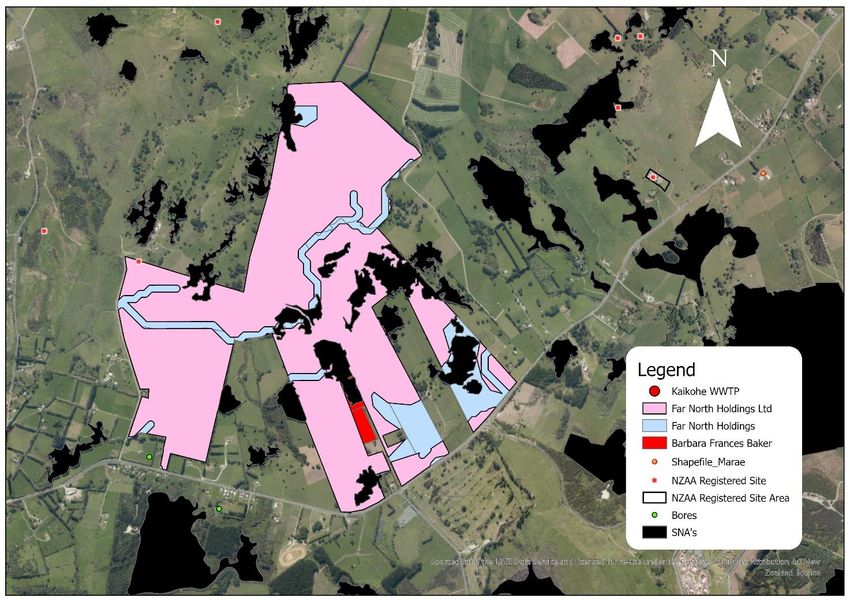
Sensitivity: General

REPORT INFORMATION AND QUALITY CONTROL

Prepared by
                          Ben Bowden
                          Graduate 3 Waters Planner
                          Far North District Council

External Peer             Garrett Hall
Review by                 Technical Director – Environments
                          Beca Ltd

Approved by
                          Ruben Wylie
                          Principal Planner Infrastructure
                          Far North District Council

                                                              2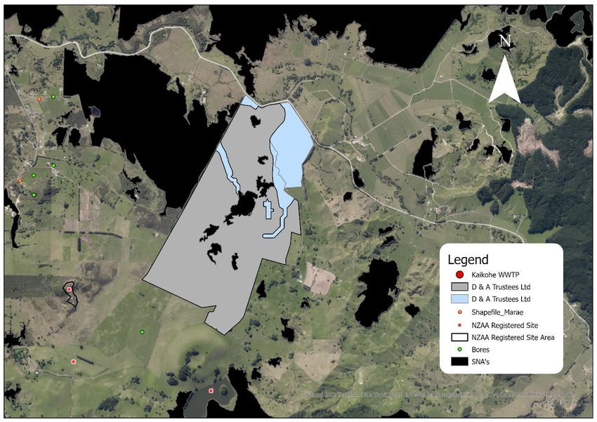
Sensitivity: General

Contents

Executive Summary .......................................................................................................................................... 4

1.     Introduction ................................................................................................................................................ 4

2.     Methodology .............................................................................................................................................. 4

3.     Land Disposal Methods ........................................................................................................................... 6

4.     Flow Summary: .......................................................................................................................................... 7

5.     Soil Drainage Class................................................................................................................................... 8

6.     Groundwater considerations .................................................................................................................. 9

7.     Hydraulic Loading Rate Design Basis ................................................................................................. 11

8.     Land Disposal Design Basis ................................................................................................................. 12

9.     First-class Exclusion Process .............................................................................................................. 12

10.        Long List Development ...................................................................................................................... 16

11.        Multi-Criteria Analysis ........................................................................................................................ 18

12.        Closing Remarks ................................................................................................................................. 20

13.        References ........................................................................................................................................... 21

                                                                                                                                                                    3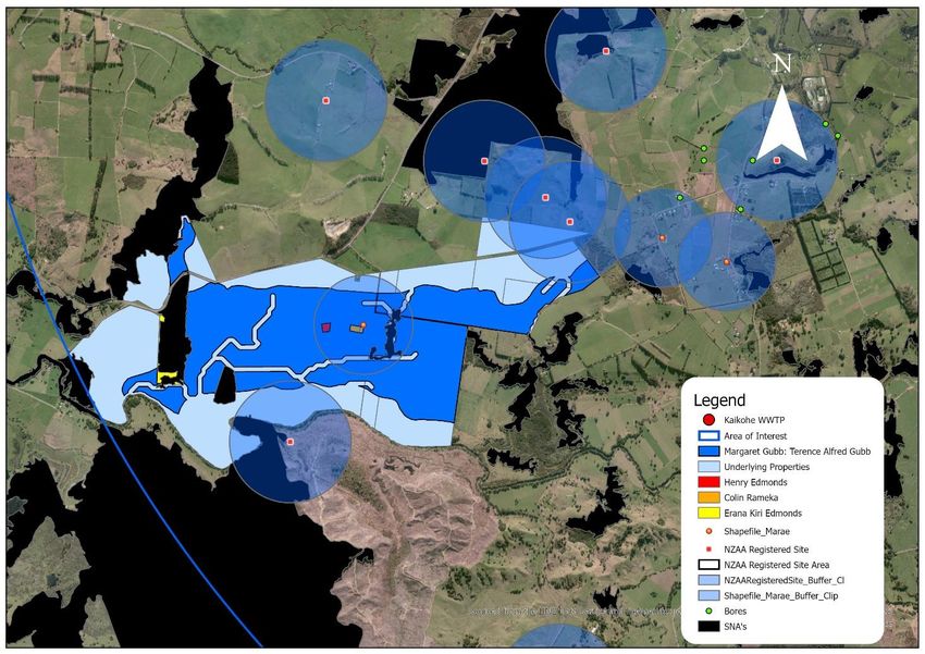
Sensitivity: General

Executive Summary

This report provides the results of an assessment to identify potential sites for land disposal of treated
wastewater from the Kaikohe wastewater treatment plant (Kaikohe WWTP). The work has been
completed by utilising geographic information systems (GIS) to identify potentially suitable sites along
with a multi-criteria analysis to shortlist potentially suitable sites for future detailed assessment.

This report assumes an average annual flow of 1938 m3/day in 2025 which is the estimated year of
installation. An average hydraulic loading rate of 1.32 - 4.3 mm/day was determined based on the
drainage classes present in Kaikohe and the indicative permeability rate associated with the clay loam
soils. Based on these assumptions, a minimum total area of 56 hectares of land is required for 100%
disposal which includes a 25% buffer to account for future growth and a storage pond.

GIS mapping using data sets from FNDC, Northland Regional Council (NRC) and other online sources were
used. Based on these data sets, it can be confirmed that there are numerous feasible options for land
disposal within 10 km of the wastewater treatment plant site. A high-level economic analysis was
undertaken by Beca to accompany the disposal assessment in order to determine the approximate costs
of land disposal. That work concluded that the costs of land disposal would be approximately $17.1M
(with a cost accuracy of -35%/+50% and excluding any required treatment process upgrade). Should the
costs be considered viable then the options found in this analysis will be considered further through on-
site testing, discussions with the current owner/s and concept design work.

1. Introduction

The Kaikohe WWTP discharges treated wastewater into the Wairoro Stream. FNDC is currently in the
process of renewing the resource consent authorising the discharge, which expires in November 2021.
Policy D.4.3 of the Proposed Regional Plan for Northland (Appeals Version – August 2019) sets out that an
application for resource consent to discharge municipal wastewater to water will generally not be granted
unless, among other things, a discharge to land has been considered and found not to be economically or
practicably viable.

The purpose of this report is to provide an initial desktop feasibility assessment and cost estimate of land
disposal of wastewater from the Kaikohe WWTP to enable a determination of land disposal practicability
and feasibility in accordance with Policy D.4.3.

2. Methodology

In order to establish the feasibility of land disposal areas, GIS software was used to initially screen site
suitability by excluding land areas that failed critical criteria. This first-class exclusion zone was initially
developed for the area of interest (AOI) based on the following criteria:

    •    20m proximity from all lakes and rivers.
    •    20m proximity from all land not designated rural production or minerals.

                                                                                                              4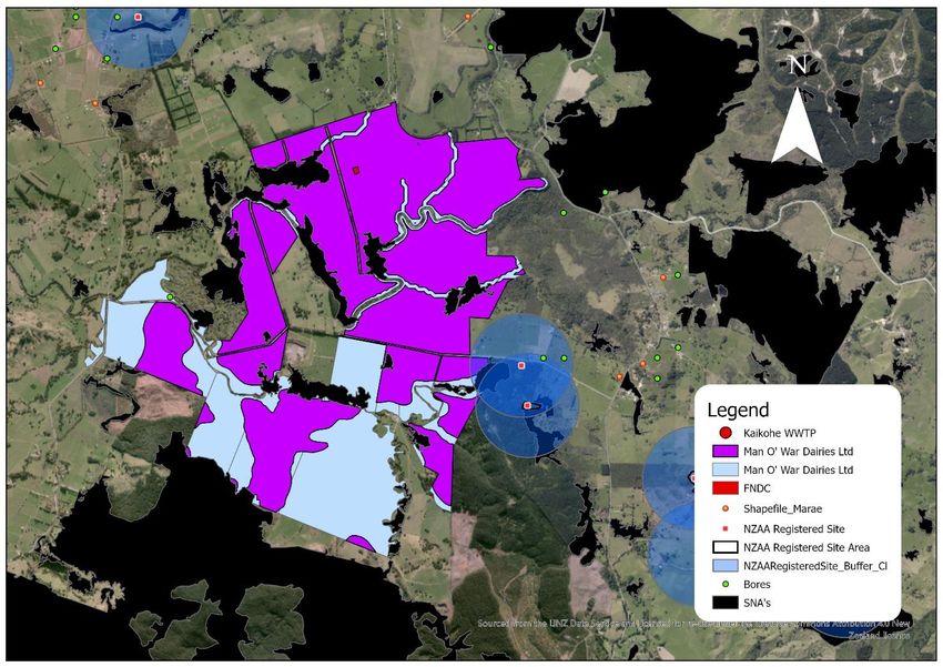
Sensitivity: General

    •    Total area for land designated as minerals.
    •    Total area for flood susceptible land.
    •    Slope > 12°.
    •    Soil drainage classes 0 – 1.

These criteria were developed based on established best practice, considering previous similar studies in
the Far North [note reference] and engineering advice provided by Beca as part of a pre-draft review
process.

A long list of sites was then created by ranking each site using the criteria and weighting shown in Table 1
below.

                                            Table 1 Long List Criteria

                                              Criteria               Weighting
                              Highest Average Drainage Class          33.3%
                              Highest Average Hydraulic Loading Rate  33.3%
                              Lowest Average Slope                    22.2%
                              Highest Regularity Score                11.1%

Lastly, the long list underwent a multi-criteria analysis (MCA) process in which qualitative measures are
assessed as shown in Table 2 below. This process allows for the remaining sites to be ranked based on
their suitability for land disposal so that the highest ranked can be taken forward for further analysis.

                                              Table 2 MCA Criteria

                                              Criteria                                   Weighting
        Long List Rank                                                                     35%
        Potential effects on Maori cultural sites (impacts on cultural values and sites)   35%
        Distance to WWTP                                                                   20%
        Existing Land Use (Land Cover, Statutory Considerations, SNA’s)                    10%

The analysis was achieved using the datasets found in Table 3 in order to conduct the exclusion zones and
criteria analysis referenced above.

                       Table 3 Spatial Data Sets used to Identify Land Disposal Constraints

                  GIS Dataset                                                Source
 District Plan Zones                                 Far North District Council
 Slope                                               LENZ2
 MfE river flows                                     LINZ1
 Northland Flood Susceptible Land                    Northland Regional Council
 Marae                                               Te Puni Kokiri Maps
 NZAA Registered Sites                               Far North District Council
 SNA’s                                               Far North District Council

                                                                                                          5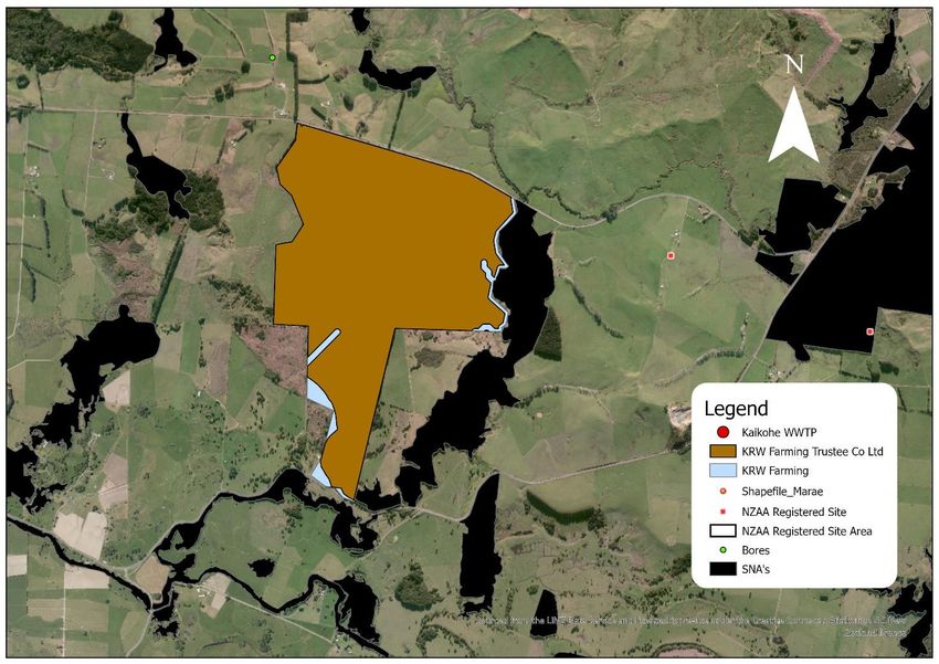
Sensitivity: General

 Bore sites                                          Northland Regional Council
 Parcel Search (Property Ownership Type)             Far North District Council
 NZLRI SOIL                                          LRIS Portal3
 LCDB v5.0                                           LRIS Portal
    1    LINZ topo1:50,000 map data
    2    Slope data layer used in the creation of Land Environments of New Zealand (LENZ) classification
    3    Identified as the same layer used in NRC Soil Map Viewer

3. Land Disposal Methods

The work of Tonkin + Taylor (2019) in Ahipara suggests that the methods for land disposal from
wastewater treatment plants are limited due to volume, soil quality, and level of treatment prior to
disposal.

Four potential land disposal methods have been identified for consideration:

    •    Soil Aquifer Treatment (SAT)
    •    Soil Moisture Discharge Methods (SM)
    •    Slow Rate Irrigation (SR)
    •    Combined Land and Water Discharge (CLWD)

According to the USEPA Process Design Manual for Land Treatment of Municipal Wastewater Effluents,
(2006) soil aquifer treatment allows for higher loading rates than the other options which would
significantly reduce the area required. However, this method requires sandy soils which are free draining
and have a fine level of pre-disposal filtration in order to operate effectively. The area surrounding the
Kaikohe WWTP contains clay loam soils in the form of young and mature volcanic basalt which are not
free draining. This can be seen in Section 5 of this report which shows the drainage classes within the AOI.
Treated wastewater exiting the Kaikohe WWTP also contains algae and other solids which can lead to
clogging of the disposal system and result in runoff. This means that SAT will not be considered further as
it is an unviable method for the Kaikohe WWTP.

Soil moisture discharge (otherwise known as soil moisture deficit) methods are designed to minimize
losses to groundwater following the disposal to land. In order to achieve this however, a greater land area
is required which was deemed too high from a practicality standpoint due to the large amount of flow
being received by the Kaikohe WWTP.

Slow rate irrigation is a method where treated wastewater is applied at a low loading rate over an
extensive area of land as determined by USEPA (2006). Application rates typically vary between 3 and 5
mm/d according to Tonkin + Taylor (2019). The effluent applied will soak into the upper soil layers where
some is lost to evapotranspiration. When the storage capacity of moisture in the soil is exceeded, the
effluent will percolate and be lost via soakage (otherwise known as soil moisture non-deficit irrigation
methods). Application methods for SR are spray irrigation (fixed sprinkler or k-line system), and pressure
compensating drip irrigation, either laid on the surface or buried within the topsoil layer (100 to 150 mm
depth).

                                                                                                           6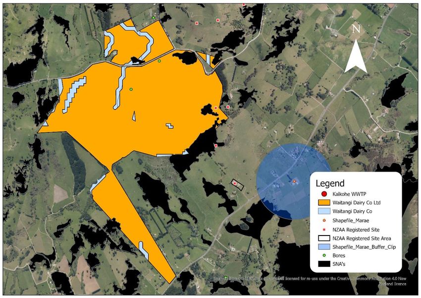
Sensitivity: General

Unfortunately, treated wastewater from the Kaikohe WWTP is not suitable for the pressure compensating
drip irrigation system due to the small diameter emitters. The wastewater effluent being discharged
contains algae that will quickly clog the emitters and compromise the operation. This was the reason the
system was not further considered for the Ahipara WWTP land disposal options assessment (Tonkin +
Taylor, 2019).

SR systems need to be developed to avoid run-off from the disposal area with all effluent being disposed
of via soakage or evapotranspiration. Therefore, irrigation will need to cease during times of high soil
moisture content when chances of runoff are high. Detailed investigations would be required to
determine when irrigation should cease for each site as effluent produced at such a time would need to
be stored in a storage pond or discharged to an alternative receiving environment. Comparison sites
indicate a requirement of 3 – 6 months’ worth of storage capacity is required if 100% discharge to land is
pursued. Whangamata which uses a precipitation index irrigation scheme requires a 3-month storage
pond, whilst a land disposal system in Mangawhai requires 6 months of storage.

SR is most suitable on land slopes up to 10° however, can exist on slopes up to 20° if the soil is suitable in
terms of drainage class. The drainage class within the area of interest is enough to allow slopes greater
than 10° to be considered, however the additional runoff risk requires further investigation. For the
purpose of this analysis sites with less than 12° have been considered as in accordance with the land
disposal report for Kohukohu by Daniel, J. (2020). This report identified that slopes above 12° risks greater
runoff development and erosion issues.

Most contaminants within treated wastewater are removed in the first few meters of soil, with finer soils
resulting in a greater removal rate. Some nitrogen may be removed through nitrification on the surface
of the soil, however, once it has entered the soil it will travel with the water. This can lead to potential
downstream effects due to nitrogen loading and should be considered when finding an appropriate site
for land disposal.

Therefore, for these reasons slow rate irrigation is the method used for this desktop analysis.

Using SR in a combined land and water discharge should also be considered where the land disposal would
be treated as a side stream to the current set-up. This would allow for surface water discharge when the
land discharge site is unable to accept treated wastewater due to soil moisture conditions. It is also noted
that at least 20% of the flow is required to go through the ponds in order to keep them ‘alive’. Therefore,
it would be ideal for the wastewater to flow through the current system before either being discharged
to land or surface water depending on soil moisture conditions.

4. Flow Summary

Flow data for the period between April 2017 and April 2020 has been collated for analysis. Table 4 below
identifies the average, median, 90th percentile, max, and average dry weather flows for 2020 (current
year), 2025 (estimated first year of operation should the option be taken forward), and 2055 (final year
of maximum consent duration).

                                                                                                            7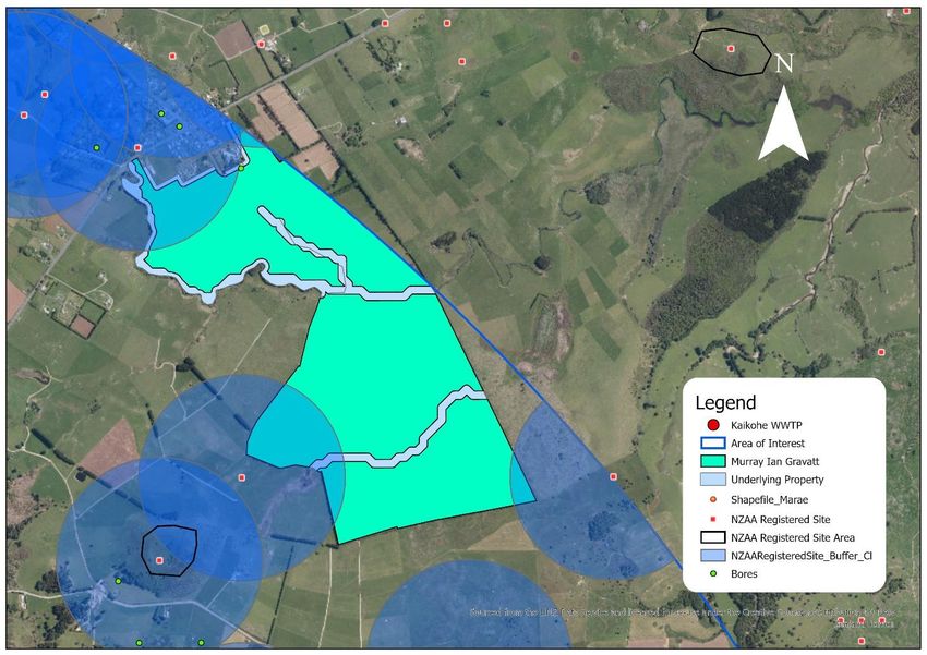
Sensitivity: General

                           Table 4 Kaikohe Wastewater Flows (APR 2017 – APR 2020)

                  Parameter                            2020                2025             2055
 Average Flow (m /day) 3
                                                       1,862               1,938            3,037
 Median Flow (m3/day)                                  1,611               1,677            2,627
 90 Percentile Flow (m /day)
    th                 3
                                                       2,983               3,105            4,865
 Maximum Flow (m3/day)                                 9,235               9,611           15,062
 Average Dry Weather Flow (m3/day)                     1,369               1,425            2,234
This flow information was taken from Harrison Grierson (2020) whom have been tasked with identifying
treatment upgrade options at the Kaikohe WWTP.

For their analysis of the flows Harrison Grierson used the inflow to Kaikohe WWTP rather than the outflow.
This was done due to the outflow measurements currently being calculated using a V-notch weir which is
less reliable than the inflow meter. The existing pond will offer storage however, there is likely to be times
in summer when evaporation causes the outflow to be less than the inflow. This means that there is some
uncertainty in sizing a land disposal system based solely on inflow data. Once an appropriate flow meter
is installed on the outlet, it is recommended that the discharge flow rate be verified so that there is greater
certainty for sizing.

5. Soil Drainage Class

Drainage classification is of fundamental importance to land disposal at a high level. It allows for an
indicative soil permeability to be determined based on the preliminary soil permeability as per the
guidelines of NZS1547 (2012).

In order to compare the potential sites with the underlying soil, a drainage class assessment was
undertaken using the following method:

    -    NZLRI Soil (2010) layer imported from LRIS portal. This layer forms the basis for the Northland
         Regional Councils (NRC) soil viewer.
    -    Using the soil factsheets supplied by NRC, the types of soils found in the AOI were assigned with
         a drainage class between 0 (No drainage) – 5 (Very well drained). Some of these soils had a range
         of drainage classes that were averaged out so that a single value could be attributed to them. (e.g.
         Omu Clay Loam (OM) has a drainage class between 2 – 4 so would become a 3).
    -    The assigned drainage classes were then applied to the imported layer which exists as polygons
         on the map. These polygons often had 2 – 3 soils attributed to them and so an average drainage
         class was used with it being rounded to the nearest whole number.

The output from the above assessment is set out in Figure 1 below.

                                                                                                             8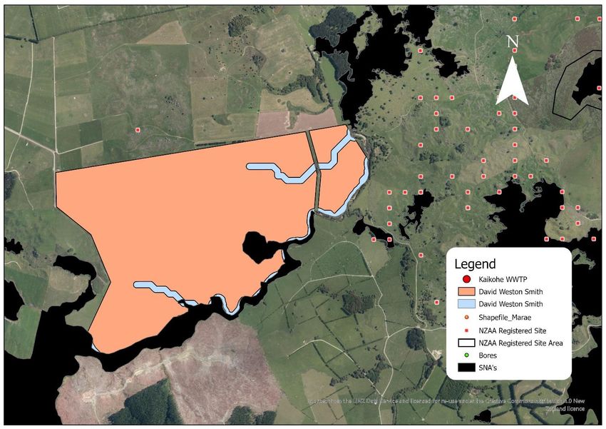
Sensitivity: General

                                      Figure 1 Soil Drainage Classes

For the purposes of this analysis a high-level approach was used to give an indicative drainage class that
could be associated with the underlying soil as a comparison tool for potential sites. On-site testing to
confirm the drainage of the soil would need to be carried out in the event any options are taken forward
for further consideration.

6. Groundwater considerations

The study area contains the Kaikohe aquifer which is defined as comprising the Kaikohe volcanic center
located at Monument Hill, the lava flows that are sourced from this center, and the underlying older
basaltic lava flows with no definable center. The aquifer is bounded by the Mangamutu and Wairoro
Streams to the north and east, Matarua Road to the west and Punakitere River to the south as shown in
Figure 2. The total area of the aquifer is 27 km2 according to Jones (2007).

Using information contained in NRC (2012) the following is assumed about the Kaikohe aquifer:

    •    Basalt overlying cretaceous siltstone
    •    Aquifer type: semi-confined
    •    Recharge estimate: 5 – 49%
    •    Saturated thickness: 50 m
    •    Transmissivity: 50 – 175 m2/day

The semi-confined status could mean additional considerations for the implementation of land disposal
which have not been included in this report. Should an option be taken forward the effects of land disposal
on groundwater will need to be considered.

                                                                                                         9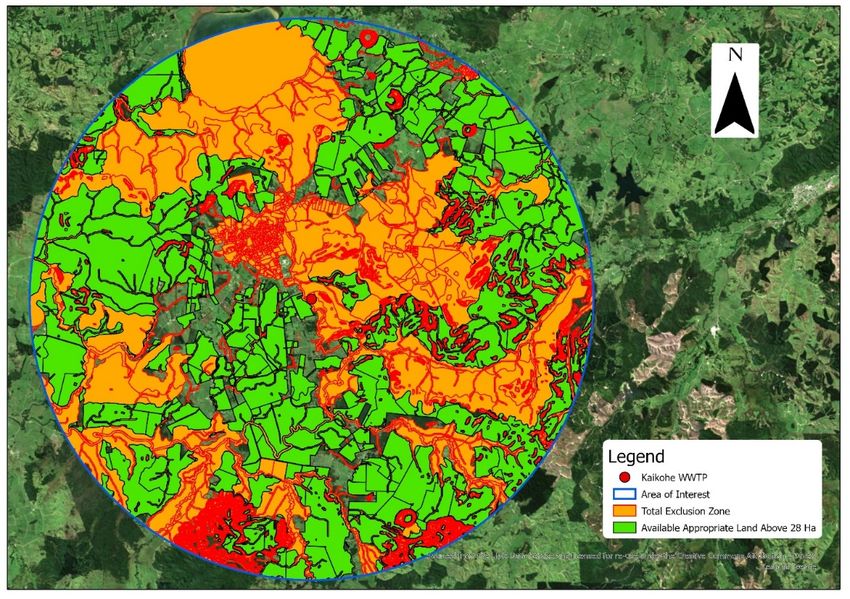
Sensitivity: General

                       Figure 2 Kaikohe Aquifer

                                                  10
Sensitivity: General
7. Hydraulic Loading Rate Design Basis
Following the method used by Jacobs (2020) the hydraulic loading rate has been determined based on an
estimated percolation rate, average annual rainfall, and the average annual evapotranspiration for
Kaikohe. Annual rainfall and evapotranspiration data used is NIWA Cliflo data from the Kaikohe Aws
weather station (#1134).
The preliminary design for soil permeability is determined using NZS1547 (2012) which provides a broad
estimate of between 60 – 120 mm/day for massive clay loam land disposal systems. This range was used
to differentiate the drainage classes being considered (2 – 5) as in Table 5 below.
Table 5 Soil Permeability
Drainage Class Preliminary Soil Permeability (mm/day)
2 60
3 80
4 100
5 120
An example of this method can be found in Table 6 below which finds a hydraulic loading rate of 4.3 mm/d
for areas with a drainage class of 5. Therefore, this result is the best possible case for the area of interest
and is within the range of 3 – 5 mm/d suggested by Tonkin + Taylor (2019) for land disposal for the Ahipara
WWTP. Ahipara holds soils with similar drainage levels to those found in Kaikohe which gives confidence
in the hydraulic loading rate reported here.
The hydraulic loading rate found for drainage class 2 however, is 1.32 mm/day which is outside the range
considered by Tonkin + Taylor (2019). Due to the imperfectly draining nature of the class this was
considered appropriate.
Table 6 Hydraulic Loading Rate Example
Parameter Units Value Comment
Soil Type - Clay Loam NRC Managing NZ Soils Fact
Sheet Viewer
Soil Permeability mm/day 120 Category 4, Table 5.2
(Preliminary Design) NZS1547 (2012)
Design Safety Factor % 5 USEPA (2006)
Design Annual mm/day 6 Soil Permeability x Design
Percolation Rate Safety Factor
Annual Rainfall mm/year 1538 NIWA (Average from past 5
years)
Annual mm/year 926 NIWA (Average from past 5
Evapotranspiration years)
Hydraulic Loading Rate mm/day 4.32 Percolation – Rainfall +
Evapotranspiration
11Sensitivity: General
8. Land Disposal Design Basis
Using the values reported for the average daily flow and the hydraulic loading rate, total land disposal
area requirements can be calculated. These land areas requirements are reported in Table 7 for drainage
class 2 and 5 to show the range considered for sizing the land disposal system. The total land requirement
includes a 25% buffer to account for a storage pond, and potential growth of irrigated area. A comparison
has also been included in Table 7 below to show the difference between 2025 and 2055 requirements
based on assumed wastewater flows in 2055.
The 25% buffer is added in addition to the exclusion zones applied as detailed in section 9 of this report.
Table 7 Total Area Required for Land Disposal
Parameter Units Drainage Class 2 Drainage Class 5
Average Daily Flow (2025) m3/day 1938 1938
Average Daily Flow (2055) m3/day 3037 3037
Hydraulic Loading Rate mm/day 1.32 4.32
Irrigated Area (2025) Ha 146.4 44.8
Irrigated Area (2055) Ha 229.5 70.2
Irrigation Application Method Spray Spray
25% Buffer Area (2025) Ha 36.6 (0.25 * (Irrigated 11.2 (0.25 * (Irrigated
Area)) Area))
25% Buffer Area (2055) Ha 57.4 (0.25 * (Irrigated 17.6 (0.25 * (Irrigated
Area)) Area))
Total Land Area Required (2025) Ha 183 56
Total Land Area Required (2055) Ha 287 88
9. First-class Exclusion Process
A first-class exclusion zone has been initially developed in Arc GIS Pro for the area of interest based on the
following criteria:
- 20 m proximity from all lakes and rivers.
- 20 m proximity from all land not designated rural production or minerals.
- Total area for land designated as minerals.
- Total area for flood susceptible land.
- Slope > 12°.
- Soil drainage classes 0 – 1.
Based on these criteria, a desktop GIS analysis was conducted by first creating a 10 km buffer boundary
around the Kaikohe WWTP. FNDC District Plan zones were included in order to determine the zoning
associated with the Area of Interest (AOI). This can be seen in Figure 3 below where the majority of the
AOI is classified as Rural Production and therefore considered as potential land for disposal.
12Sensitivity: General
Figure 3 Land Designation
Using this zoning data, all non-Rural Production land was excluded from consideration and a 20m buffer
was created between rural production zoned land and all other zoned laned. The exception to this rule
was the minerals zone as it was deemed that this zoning does require the same degree of separation due
to the anticipated land use not being sensitive to the land disposal activity.
River lines were then produced using data from LINZ TOPO50 NZ River Centerlines and given a buffer of
20 m as per the exclusion criteria. The output is depicted in Figure 4 below. Rivers/streams are widespread
over the AOI and act as a considerable constraint compared to the other exclusion criteria.
The flood plains were also considered a total exclusion zone and have been included in Figure 4. Because
no flood modeling has been completed within the surrounding catchment, the Northland Regional Council
Flood Susceptible Land data was used to demarcate 100-year floodplains. It has been used as an exclusion
zone due to the potential damage/contamination that could be caused in the event of a flood.
13Sensitivity: General
Figure 4 River, Lake, and Flood lands Exclusion Zone
Slopes greater than 12° have been added as an exclusion zone due to the propensity for runoff to be
produced from these slopes. Data from LENZ was used first to project the slope data based on a 25m
digital elevation model fitted to 20m digital contour data as seen in Figure 5 below. Following this, the
areas above 12° were added to the exclusion zone.
Figure 5 Slope Exclusion Zone
14Sensitivity: General
As can be seen in section 5 of this report, the soil drainage map allows for classes 0 – 1 to be excluded
from further consideration. Based on all the first-class exclusions a total exclusion zone could then be
formed as per Figure 6 below.
Figure 6 Total Exclusion Zone
Using the total exclusion zone layer, the available land is shown in Figure 7 below.
Figure 7 Available Land
15Sensitivity: General
However, there is land in the AOI which is not considered part of the available land or exclusion zone. This
is due to a data cleaning process outlined below:
- Available land data initially cleaned of any land area below 1 Ha.
- Additional cleaning of remaining data with parcel intents labelled ROAD, HYDRO, etc. which hold
unusable land for disposal.
- Parcel properties are merged based on ownership and proximity. This is done so that total land
available from a single owner/ownership group can be used providing that the parcel properties
are close together.
- Any land remaining with less than 28 Ha is excluded due to being less than half of the lowest
disposal area requirement calculated.
This process has provided an extended list of options which can be further considered for their potential
as land disposal sites. In this case there were 100 remaining sites of interest. The number of sites is further
refined into a long list using the qualitative method detailed in section 10 of this report.
10. Long List Development
The long list was created using the criteria shown in Table 8 below. This initial method of ranking the
potential sites was purely quantitative in nature.
Table 8 Long List Criteria
Criteria
Total Available Area
Average Hydraulic Loading Rate
Average Slope
Regularity Score
The long list criteria were determined as follows:
• The resulting 100 sites found in the first-class exclusion process were joined with the underlying
soil drainage data using the union tool in Arc GIS Pro. This allowed for the drainage classes of each
option to be analyzed.
• Multiple different soil drainage class polygons underlined each option and therefore a percentage
was developed to show how much of each option contained each drainage class. In order to
achieve this analysis, the available land area information was extracted from Arc GIS Pro and
transferred to Excel. Here, the total area of each option was first found by summing the areas for
all associated drainage class polygons. This allows for the area of each drainage class to be given
a percentage value for the area they make up of an option in relation to its total area.
• In order to come up with a numerical field that can be ranked, the percentage values of each
drainage class are multiplied by its associated hydraulic loading rate (as calculated in section 6 of
this report). This gives each option an indicative hydraulic loading rate which can then be used to
score the drainage level of each option.
16Sensitivity: General
• The average slope of each option was calculated in Excel using the AVERAGE function for all soil
polygons found within an option. This gives an indicative value for the slopes on-site for each
option and allows for them to be scored against each other to find the options with the lowest
average slope.
• Lastly, the regularity is calculated by using the ratio AREA:Perimeter2. This means that cuts within
the available areas produced from exclusion criteria result in a lower regularity as they raise the
perimeter of the polygons in Arc GIS Pro.
Using the output from the above analysis, scores can be set up for each of the long list criteria based on
where an option sits for a certain criterion in relation to the other options. Percentiles were then used to
create 5 possible scores for each criterion based on the results found for all 100 options. An example of
this is shown in Table 9 below which details how options are scored for their total available area.
Table 9 Total Available Area Scoring
Percentile Score
Below 20% 1
Below 40%, Above 20% 2
Below 60%, Above 40% 3
Below 80%, Above 60% 4
Above 80% 5
The scoring for each of the criterion were then used to develop the long list using the weightings shown
in Table 10 below. Total available area and hydraulic loading rates were considered the most important
factors for considering land disposal and therefore got a higher weighting. As slopes above 12° were
excluded earlier this was deemed a less important criterion though it is noted that the lower the slope on-
site, the better it is for land disposal and therefore included. Lastly, the regularity has the lowest weighting
as it is only being used so that the most irregular sites are not considered. The building constraints
exhibited in those options would make implementation difficult.
Table 10 Long List Weighting
Criteria Weighting
Highest Total Available
33.3%
Area
Highest Average
33.3%
Hydraulic Loading Rate
Lowest Average Slope 22.2%
Highest Regularity
11.1%
Score
The weightings for each of the criteria were then multiplied by the associated score for each option to
develop an overall ranking for each site. Based on this ranking, the top 11 sites were taken forward for
further analysis using a multi-criteria analysis (MCA) which considered qualitative information. These 11
sites are included in Appendix B alongside the information used for the MCA. It is important to note that
this does not rule out the remaining 89 options from consideration. Should the options taken forward
17Sensitivity: General
prove unviable then additional sites from the available land list can be taken forward based on their
ranking to be considered further.
11. Multi-Criteria Analysis
Finally, a multi-criteria analysis (MCA) has been carried out to further rank the long list options. The MCA
considers four additional criteria as shown in Table 11 below. The initial weighting of the criteria is as
below, however, numerous different weighting scenarios were considered in a sensitivity analysis.
On top of the criteria listed in Table 11, bore locations and property ownership type (Public, Private,
Maori) were found for each site. It was deemed that any bores onsite could be closed off before
implementation of land disposal and therefore not considered in the MCA. Ownership type was excluded
from the MCA and was instead set for later consideration should any sites be taken forward. However, in
this case all 11 sites are on private freehold land.
Table 11 MCA Criteria
Criteria Weighting
Long List Rank 35%
Potential effects on Maori cultural sites (impacts on cultural values and sites) 35%
Distance to WWTP 20%
Existing Land Use (Land Cover, Statutory Considerations, SNA’s) 10%
The initial long list ranking for each of the options was first recognized as a factor which needed to be
considered due to its importance in site selection.
Impacts that the options could have on cultural sites and values was deemed an important consideration.
This was achieved by locating all Marae and NZAA sites within a range of 500 m of each site and evaluated
the level of its cultural significance. An example of this is that one of the options held a Marae at its center
and would therefore show significant risk from a cultural perspective and would score low. However, this
is an initial evaluation only, and a separate evaluation will have to be done for any sites taken beyond the
scope of this report. The additional evaluation will need to incorporate an engagement process with local
iwi.
Distance to the wastewater treatment plant has been included to allow for cost differences in reticulation,
as cost has not been included as a criterion in the MCA. This is due to an economic analysis being
conducted by Beca which uses assumptions based on the results found for this report as can be seen in
Appendix A.
Lastly, the existing land use has been determined by using the land cover database (LCDB), and locations
of Significant Natural Areas (SNA) in the area of interest. As with the drainage class, the land cover
database is joined with the available land using a union in GIS and a percentage calculated for how much
of the option is covered by certain types of land (e.g. High Production Exotic Grassland). SNA’s are found
in FNDC’s geodatabase and if they cross one of the long-listed options, their impact on the usage of the
site is determined and scored appropriately.
18Sensitivity: General
The results of this analysis can be seen below in Figures 8 – 9. Figure 8 shows the results of the chosen
weighting from Table 11, where Figure 9 shows the variance exhibited by the sensitivity analysis in which
differing weightings were compared.
5.00
4.50
4.00
3.50
3.00
2.50
2.00
1.50
1.00
0.50
0.00
Option Option Option Option Option Option Option Option Option Option Option
1 2 3 4 5 6 7 8 9 10 11
Land Use Distance to WWTP Proximity to Cultural Sites Long-List Ranking
Figure 8 MCA Results
Figure 8 shows that for the chosen weighting, option 4 which is currently owned by Far North Holdings
presents the best case for land disposal. Far North Holdings land has been planned for use as a water
storage site and industrial park which may inhibit the purchasing of the land for land disposal purposes.
Following this, options 2, 5, and 10 are the next highest scoring. These sites are owned by D & A Trustees,
KRW Farming, and Waitangi Dairy Co. respectively. These options are all viable and should be considered
further in the event the Far North Holdings land proves to not be an option.
The next set of options include 3, 6, and 8 which are owned by David Weston Smith, Man O’ War Dairies,
and Murray Ian Gravatt respectively. This set, although assessed as being weaker options for land disposal
are still up for consideration should the options ranked above them not be possible.
The last set are options 1, 7, 9, and 11 which are owned by Clyde Rex Faithful, Margaret Gubb, Smith
Brothers, and Wi Te Pariha Whiu respectively. All these options scored a zero in their impact on cultural
sites and therefore carry a greater risk for their purchase. A score of zero was only given if a cultural site
of significance was found inside of the available land option. These options should only be considered
after assessing the alternative options ranked higher and finding them unsuitable.
19Sensitivity: General
5.00
All at 25%
85% Cultural
4.50
50% Cultural, 30% Long-List
30% Cultural, 50% Long-List
4.00 Original
3.50
3.00
2.50
2.00
1.50
1.00
0.50
0.00
Option 1 Option 2 Option 3 Option 4 Option 5 Option 6 Option 7 Option 8 Option 9 Option 10 Option 11
Figure 8 MCA Sensitivity Analysis
As the cultural impact and the ranking from the long list were deemed the most important, the sensitivity
analysis predominantly revolved around those two criteria. The sensitivity analysis shows a general trend
that supports the results found in the initial weighting which gives confidence in the decision.
Should none of the sites prove viable however, the MCA will be reconducted using the next set of available
land options identified in the initial ranking. This process can be completed for as many of the available
land options as required until either a site has been selected or there are no available options left.
12. Closing Remarks
The associated economic analysis has been prepared by Beca and is attached as appendix A. This analysis
has been achieved at a high level using a general case scenario with a range of -35% to +50% in its
estimations. The results estimated a total cost of $17.1M for land disposal and up to $49.7M in
combination with the current options being considered in Harrison Grierson’s option report.
This analysis will be a determining factor for the potential development of a land disposal system at the
Kaikohe WWTP. If the cost is too high for consideration, then the process of investigating the different
options will stop here. However, if it is decided that the option is viable then negotiations will begin with
the site owners. On-site testing will also be carried out to confirm the desktop analysis and investigate
any unforeseen issues with the sites. This will include an assessment of potential environmental effects
20Sensitivity: General
of the proposed treated wastewater discharge regime. Costs will also need to be revised and updated
based upon the results of further technical and environmental investigations.
13. References
• Land Information New Zealand. (2020, 17 Feb). NZ River Centrelines (Topo, 1:50k). Retrieved
from https://data.linz.govt.nz/layer/50327-nz-river-centrelines-topo-150k/
• Daniel, J. (2020, 17 Feb). Appendix B – Land Disposal Site Selection Analysis Report. Jacobs New
Zealand Limited.
• Slaney, A., Daniel, J., & MacDonald, B. (2020, 9 March). Kohukohu WWTP issues and options.
Jacobs New Zealand Limited.
• Ross, H., Bryce, T., & Cussins, T. (2019, 31 October). Ahipara WWTP preliminary land disposal
options review. Tonkin & Taylor Ltd.
• USEPA. (2006). Process Design Manual Land Treatment of Municipal Wastewater Effluents.
Retrieved from
https://cfpub.epa.gov/si/si_public_record_report.cfm?Lab=NRMRL&dirEntryId=159124
• Bore Logs. (2020, 28 July). Northland Regional Council. Retrieved from https://data-
nrcgis.opendata.arcgis.com/datasets/bore-logs
• Northland Regional Council. Northland Soils Factsheet Viewer. (2020). Retrieved from
https://nrcgis.maps.arcgis.com/apps/webappviewer/index.html?id=fd6bac88893049e1beae97c
3467408a9.
• NZS1547. (2012). Australian/New Zealand standard: onsite domestic wastewater management.
• Evaporation. (2020). Cliflo, NIWA. Retrieved from
https://cliflo.niwa.co.nz/pls/niwp/wgenf.genform1_proc.
• Rainfall. (2020) Cliflo, NIWA. Retrieved from
https://cliflo.niwa.co.nz/pls/niwp/wgenf.genform1_proc.
• LENZ – Slope. (2011). LRIS Portal. Retrieved from https://lris.scinfo.org.nz/layer/48081-lenz-slope/.
• LRIS – LCDB. (2019). LRIS Portal. Retrieved from https://lris.scinfo.org.nz/layer/104400-lcdb-v50-
land-cover-database-version-50-mainland-new-zealand/.
• LRIS – NZLRI Soil. (2010). LRIS Portal. Retrieved from https://lris.scinfo.org.nz/layer/48066-nzlri-soil/.
• Jones, D. (2007, 2 Feb). Preliminary Hydrogeological Investigations – Four Northland Aquifers.
SKM.
• Northland Regional Council. Groundwater. (2012). Retrieved from
https://www.nrc.govt.nz/resource-library-archive/environmental-monitoring-archive2/state-of-
the-environment-report-archive/2011/state-of-the-environment-monitoring/our-
freshwater/groundwater/.
21Sensitivity: General
22Level 2 Waitomo House,
6 Garden Place, Hamilton,
3240, New Zealand
T: +64 7 838 3828 // F: +64 7 838 3808
E: info@beca.com // www.beca.com
Far North District Council 30 October 2020
PO Box 752
Kaikohe 0440
New Zealand
Attention: Mandy Wilson
Dear Mandy
Kaikohe WWTP Cost Estimate
As per our peer review proposal dated 27 August 2020, a cost estimate has been prepared for a high-level
economic analysis of the expected land discharge costs for the Kaikohe Wastewater Treatment Plant
(WWTP).
The cost estimate has been prepared based on the assumed key elements in the schematic in Figure 1,
and include allowances for preliminary and general contractor costs, and fees and investigations, to give a
whole-project cost estimate. This cost estimate is indicative only based off a series of high-level
assumptions. No specific land sites have been identified and further concept design and costing work will
be required to generate a cost estimate for specific sites and associated site-specific constraints.
The costs for options for the WWTP upgrade have been provided by others, and have not been included in
this estimate.
Storage Spray irrigation area 50 ha
WWTP
167,580 m3 With buffers 100 ha
Pump 5 km Rising Booster
station main station
Figure 1 Schematic of high-level land discharge design used for cost estimation
Table 1 Cost estimate for land discharge scheme
Item Cost (NZD)
$3.9M
Conveyance to irrigation site
$4.7M
Irrigation scheme and storage
$2.3M
Fees and investigations
$4.1M
General
Beca // 30 October 2020 //
3257576-729882073-39 // Page 1Item Cost (NZD)
$2.0M
Land Purchase
$17.1M
Total Estimated Cost (-35% to +50%) excluding GST
Estimation Notes and Assumptions
◼ This estimate is an order of magnitude cost with an expected accuracy range of between -35% to
+50%
◼ 50 ha land area for irrigation is assumed to be required (based on indicative work undertaken by
FNDC) plus 100% for storage, buffers and non-irrigable areas or the site and harvest stand down
periods. This buffer area may be reduced following the identification of a specific site.
◼ Spray irrigation proposed – nozzle size allows for larger particulates, for example algae from ponds
◼ Three months storage of 167,580 m3 is assumed (supplied by FNDC, appears to be based on 2020
average flow)
◼ Geotechnical investigations included for rising main and irrigation site
◼ Irrigation site is assumed to require 5 km of pipeline from the WWTP to the irrigation site
◼ Pump and rising main sizing has been based on schemes for WWTPs of a similar size
Exclusions
◼ Legal fees
◼ Consents
◼ Ground improvement works
◼ Goods and Services Tax
◼ Contingency
Limitations
It should be noted that the cost estimates provided as part of the Services are not a statement of absolute
cost, rather they will have an accuracy range commensurate with various factors such as the extent of
relevant information provided, the certainty of data and the level of detail available at the time of
preparation.
The high level cost estimates presented in this letter are typically developed based on extrapolation of
recent similar project pricing, historical quotes for some equipment items, industry unit rates and Beca’s
general experience. The estimates are based on incomplete design and other information and are not
warranted or guaranteed by Beca. The accuracy of these estimates is not expected to be better than
approximately -35% to +50% for the scope of work described in this report. Further design should be
undertaken if a more reliable estimate is required.
Beca // 30 October 2020 //
3257576-729882073-39 // Page 2Total Scheme Cost
A review of the short-listed options provided by Harrison Grierson in their Options Report (draft, October
2020) found that options 3, 4A and 4B are the most likely to meet consent conditions for discharge to
stream when the storage pond for the irrigation is fully utilised, and irrigation is not possible. The times
when a discharge to stream is potentially required is when pond-based systems are at their lowest
performance levels, generally being in the wet and cold months when treatment processes produce the
lowest quality treated effluent of the year, and ammonia (currently the failing determinand) is most at risk.
This is based on experience with pond treatment systems in other regions using the technologies in options
1 and 2 which are not meeting compliance with their resource consents.
Potential total costs for a WWTP upgrade and land discharge scheme are presented in Table 2 below.
Table 2 Total scheme capital cost using Harrison Grierson WWTP option costs#
Option HG WWTP Option cost Total scheme cost*
$6.5M-$8.9M $17.6M-$34.6M
3. IDAL
$15.0M-$20.6M $26.1M-$46.3M
4A. side stream BNR
$17.5M-$24.0M $28.6M-$49.7M
4B. BNR
#Note: Beca accepts no responsibility for the costs provided by others
*Total scheme costs have been calculated to include the high/low range for the land discharge costs
References
Kaikohe WWTP Options Assessment, Harrison Grierson, Draft October 2020
FNDC Kaikohe WW Peer Review 01.10.20.pdf
Yours sincerely
Nicola Marvin
Senior Environmental Scientist
on behalf of
Beca Limited
Phone Number:
Email: nicola.marvin@beca.com
Beca // 30 October 2020 //
3257576-729882073-39 // Page 3Kaikohe Land Disposal Options Assessment – Appendix B
12/11/2020
APPENDIX B – SHORTLISTED OPTIONS
The following options have been identified as the most feasible for land disposal of wastewater in the Kaikohe
area of interest. Table 1 below is a list of all types of land uses identified and their associating abbreviations:
Table 1. Land Use Abbreviations
Land Use Abbreviation
High Producing Exotic Grassland HPEG
Lake or Pond LP
Indigenous Forest IF
Manuka and/or Kanuka MK
Exotic Forest EF
Mixed Exotic Shrubland MES
Broadleaved Indigenous Hardwoods BLIH
Gorse and/or Broom GB
Forest - Harvested HF
Orchard, Vineyard or Other Perennial Crop OV
Urban Parkland/Open Space UP
Built-up Area (settlement) BAOption 1 – Clyde Rex Faithful
Cultural Sites: Burial Area Onsite – South. Pa to the West of the site.
Bores: On-site, Active - Stock.
Distance to WWTP: 9.24 km (11th)
Landowner Type: Private – FSIM, DCDB.
Land Use: 92% HPEG, 7.9% IF, 0.01% LP.
SNA’s: Bullman Road Broadleaved Remnants Onsite.
Total Available Average Hydraulic Average Slope (°) Regularity Overall Score
Area Loading Rate (Area/Perimeter2) (Overall Ranking)
47.43 Ha (2/5) 3.32 mm/day (5/5) 1.14 (5/5) 0.02 (5/5) 36 (4th)Option 2 – D&A Trustees
Cultural Sites: None within 500 m
Bores: None
Distance to WWTP: 6.5 km (5th)
Land Ownership: Private, FSIM.
Land Use: 84.9% HPEG, 7.7% EF, 6.6% IF, 0.9% MK.
SNA’s: Tauanui Volcanic Broadleaved Remnant Onsite. Swamp forest to the NW. Forest N.
Total Available Average Hydraulic Average Slope (°) Regularity Overall Score
Area Loading Rate (Area/Perimeter2) (Overall Ranking)
182 Ha (5/5) 2.91 mm/day (4/5) 6.33 (3/5) 0.018 (4/5) 37 (3rd)Option 3 – David Weston Smith
Cultural Sites: Stone Structures
Bores: None
Distance to WWTP: 7.9 km (7th)
Land Ownership: Private, DCDB.
Land Use: 59.7% HPEG, 35.1% MES, 3.75% MK, 0.9% BLIH, 0.6% IF.
SNA’s: Titihuatahi Forest and Shrubland.
Total Available Average Hydraulic Average Slope (°) Regularity Overall Score
Area Loading Rate (Area/Perimeter2) (Overall Ranking)
155 Ha (4/5) 2.93 mm/day (4/5) 2.44 (5/5) 0.016 (4/5) 38 (2nd)Option 4 – Far North Holdings
Cultural Sites: Onsite - Gum Digging Holes.
Bores: Off-site, Active – Irrigation.
Distance to WWTP: 3.6 km (1st =)
Land Ownership: Private, DCDB, FSIM.
Land Use: 85.3% HPEG, 9.8% IF, 3.5% HF, 0.6% GB, 0.5% BLIH.
SNA’s: Kopenui Stream Remnants. Young’s Kahikatea Remnant.
Total Available Average Hydraulic Average Slope (°) Regularity Overall Score
Area Loading Rate (Area/Perimeter2) (Overall Ranking)
205 Ha (5/5) 3.32 mm/day (5/5) 5.61 (4/5) 0.004 (2/5) 40 (1st)Option 5 – KRW Farming
Cultural Sites: None within 500 m
Bores: None
Distance to WWTP: 8.2 km (8th)
Land Ownership: Private, DCDB, FSIM.
Land Use: 97.9% HPEG, 1.2% GB, 0.9% EF.
SNA’s: Mangatoa/Punakitere Riverine.
Total Available Average Hydraulic Average Slope (°) Regularity Overall Score
Area Loading Rate (Area/Perimeter2) (Overall Ranking)
186 Ha (5/5) 2.2 mm/day (2/5) 4 (5/5) 0.028 (5/5) 36 (4th)Option 6 – Man O’ War Dairies Ltd.
Cultural Sites: Pa–south east.
Bores: Off-site, active monitoring
Distance to WWTP: 3.6 km (1st =)
Land Ownership: Private, FSIM, DCDB.
Land Use: 82.8% HPEG, 7.9% IF, 5.5% EF, 3.4% GB, 0.3% BLIH, 0.1% OV, 0.01% MES.
SNA’s: Huehue & Maungakawakawa Forest.
Total Available Average Hydraulic Average Slope (°) Regularity Overall Score
Area Loading Rate (Area/Perimeter2) (Overall Ranking)
600 Ha (5/5) 3.05 mm/day (4/5) 5.57 (4/5) 0.002 (1/5) 36 (4th)Option 7 – Margeret Gubb
Cultural Sites: Marae – Onsite.
Bores: Off-site, Active – Stock.
Distance to WWTP: 5.96 km (4th)
Land Ownership: Private, DCDB. Orange = Maori. Yellow = Maori.
Land Use: 94.6% HPEG, 2.6% IF, 1.5% MK, 1.0% UP, 0.4% BLIH, 0.04% GB.
SNA’s: Kaipeha Swamp. Mangatoa/Punakitere Riverine N.
Total Available Average Hydraulic Average Slope (°) Regularity Overall Score
Area Loading Rate (Area/Perimeter2) (Overall Ranking)
219 Ha (5/5) 3.11 mm/day (4/5) 4.62 (4/5) 0.004 (1/5) 36 (4th)Option 8 – Murray Ian Gravatt
Cultural Sites: Ridge Pa – West. Hill Pa – East. Hotel – North.
Bores: On-Site, Active – Domestic. North – Commercial water supply.
Distance to WWTP: 8.8 km (10th)
Land Ownership: Private, DCDB.
Land Use: 91.5% HPEG, 7.7% EF, 0.8% MES, 0.02% BA.
SNA’s: None.
Total Available Average Hydraulic Average Slope (°) Regularity Overall Score
Area Loading Rate (Area/Perimeter2) (Overall Ranking)
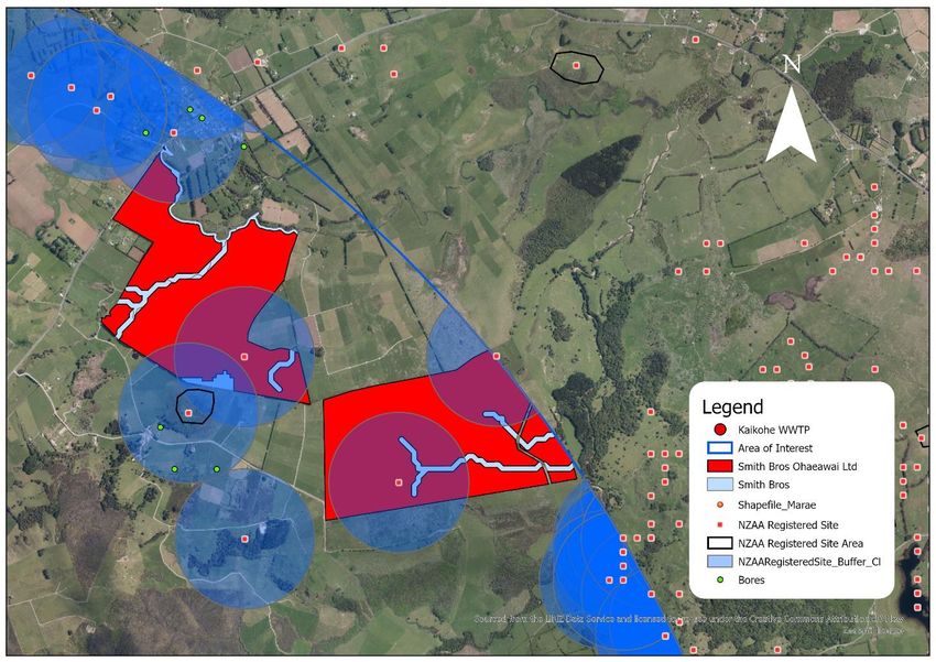
153 Ha (4/5) 2.96 mm/day (4/5) 3.24 (5/5) 0.01 (3/5) 37 (3rd)Option 9 – Smith Brothers
Cultural Sites: Pa – Onsite. Pa – south. Hill Pa – northeast.
Bores: Offsite – Domestic, monitoring.
Distance to WWTP: 8.25 km (9th)
Land Ownership: Private, DCDB.
Land Use: 98.7% HPEG, 0.7% EF. 0.5% IF, 0.1% MES.
SNA’s: None.
Total Available Average Hydraulic Average Slope (°) Regularity Overall Score
Area Loading Rate (Area/Perimeter2) (Overall Ranking)
257 Ha (5/5) 2.82 mm/day (4/5) 5.18 (4/5) 0.006 (2/5) 37 (3rd)Option 10 – Waitangi Dairy Co.
Cultural Sites: Gunfighter Pa – South. Tarahi Pa – Northeast. Cemetery – North. Pit/Terrace
Onsite.
Bores: 2 Onsite, Active – Stock. North, Active – Domestic/Irrig.
Distance to WWTP: 4.9 km (3rd)
Land Ownership: Private, DCDB, FSIM.
Land Use: 93.9% HPEG, 4.7% IF, 1.3% EF, 0.1% LP, 0.01% HF.
SNA’s: Ngawha Bush. Remuera Settlement Road Remnants NW.
Total Available Average Hydraulic Average Slope (°) Regularity Overall Score
Area Loading Rate (Area/Perimeter2) (Overall Ranking)
205 Ha (5/5) 3.32 mm/day (5/5) 6.64 (3/5) 0.007 (2/5) 38 (2nd)Option 11 – Wi Te Pariha Whiu
Cultural Sites: Onsite – Hill Pa. South – Kopaki Pa.
Bores: Offsite, Active.
Distance to WWTP: 7.25 km (6th)
Land Ownership: Private, DCDB.
Land Use: 83.6% HPEG, 9.9% GB, 6.5% IF.
SNA’s: Huehue and Maungakawakawa Forest.
Total Available Average Hydraulic Average Slope (°) Regularity Overall Score
Area Loading Rate (Area/Perimeter2) (Overall Ranking)
69 Ha (3/5) 3.32 mm/day (5/5) 5.88 (4/5) 0.02 (4/5) 36 (4th)You can also read