Kawartha Heights Neighbourhood Action Plan: Toward an active, greener future - In association with: GreenUP
←
→
Page content transcription
If your browser does not render page correctly, please read the page content below
In association with:

Kawartha Heights Neighbourhood Action Plan:
Toward an active, greener future
Front matter

© 2019 Peterborough GreenUP Association. All rights reserved.

Author
Hayley Goodchild, SUN Program Coordinator, GreenUP

Editorial Team
Heather Ray, Water Programs Manager, GreenUP
Jenn McCallum, SUN Program Coordinator, GreenUP
Brittany Harding, Water Education and Outreach Coordinator, GreenUP
Brianna Salmon, Executive Director, GreenUP
Adriana Gomez, Senior Program Manager, Toronto and Region Conservation
Authority’s Sustainable Neighbourhood Action Program

Sustainable Urban Neighbourhoods Advisory Committee
Melanie Kawalec, City of Peterborough
Ian Boland, City of Peterborough
Phil Jacobs, City of Peterborough
Rob Anderson, City of Peterborough
Christie Gilbertson, City of Peterborough
Jill Bishop, Nourish Project
Donald Fraser, East City-Curtis Creek representative
Meredith Carter, Otonabee Region Conservation Authority
Jennifer Clinesmith, Otonabee Region Conservation Authority
Paul Finigan, Otonabee Region Conservation Authority
Carlotta James, Peterborough Pollinators
Janet Dawson, Peterborough Public Health
Monique Beneteau, Peterborough Public Health
Trish O’Connor, Fleming College
Terri Keough, Peterborough Utilities Group
Andrea Connell, Transition Town Peterborough
Shelley Strain, Trent University and Kawartha Heights representative
Beth Stanley, Canadian Canoe Museum
Adriana Gomez, Toronto and Region Conservation Authority

GreenUP extends special thanks to those who provided additional support,
including Nicole Schleifer, Charmalee Sandanayake, Andrew Nichols, Leighanne
Howard, Rachel Barrington, Dawn Pond, and Alex Larkin.

SUN’s partner organizations include GreenUP, Toronto and Region Conservation
Authority, the City of Peterborough, Nourish, and Otonabee Conservation.

Funding for this project has been generously provided by the Ontario Trillium
Foundation.

                                        ii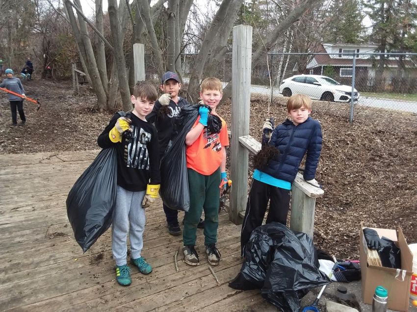
We respectfully acknowledge that GreenUP is located on Treaty 20 Michi Saagiig
territory and in the traditional territory of the Michi Saagiig and Chippewa Nations,
collectively known as the Williams Treaties First Nations, which include: Curve
Lake, Hiawatha, Alderville, Scugog Island, Rama, Beausoleil, and Georgina
Island First Nations.

GreenUP respectfully acknowledges that the Williams Treaties First Nations are
the stewards and caretakers of these lands and waters in perpetuity, and that
they continue to maintain this responsibility to ensure their health and integrity for
generations to come.

                                          iii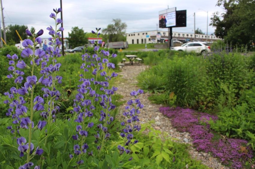
How to use this document

The Kawartha Heights Neighbourhood Action Plan is a collaborative ten-year
vision and guide for achieving greater sustainability and resilience to the impacts
of climate change.

This accessible document is intended for municipal staff, partners,
neighbourhood residents, schools, businesses, and community and faith groups
who wish to review a detailed version of the Plan. A summary version of the
Action Plan is available on the SUN website.

Unless otherwise indicated, all maps in this report were generated by the author
using QGIS 3 and use a NAD83 UTM 17N projection. Aerial imagery and data
layers courtesy of the City of Peterborough unless stated otherwise. Consult
References for a complete list of shapefiles used.

                                         iv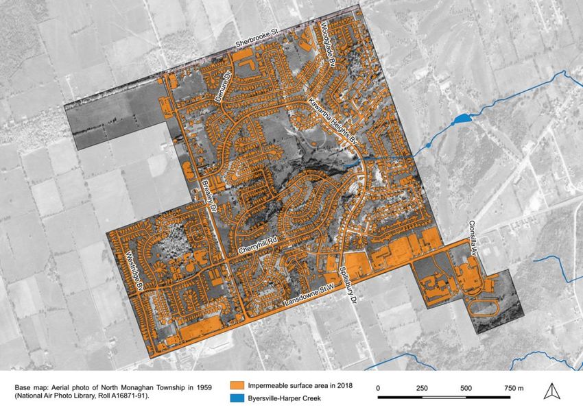
Table of Contents
Front matter ............................................................................................................ ii

How to use this document ................................................................................... iv

Executive summary ............................................................................................ viii

What is SUN?.......................................................................................................... 1

   Introduction ................................................................................................................... 1

   Governance structure .................................................................................................. 1

   Program background and neighbourhood selection ............................................... 2

   Engagement process ................................................................................................... 3

      Phase 1 (2017–2018) ................................................................................................. 3

      Phase 2 (2019) ........................................................................................................... 4

Neighbourhood overview...................................................................................... 6

   Introduction ................................................................................................................... 6

   Summary of neighbourhood baseline conditions .................................................... 7

      Soil, topography, and water ........................................................................................ 7

      Urban forest, habitat, and wildlife ............................................................................... 9

      Demographics and community values ....................................................................... 9

      Built environment ...................................................................................................... 11

      Transportation ........................................................................................................... 12

      Parks and other community services ....................................................................... 12

Sustainability themes & long-term outcomes .................................................. 14

   Water ............................................................................................................................ 14

   Habitat and urban forest ............................................................................................ 14

   Healthy, active transportation and recreation ......................................................... 14

   Community building ................................................................................................... 15

                                                                  v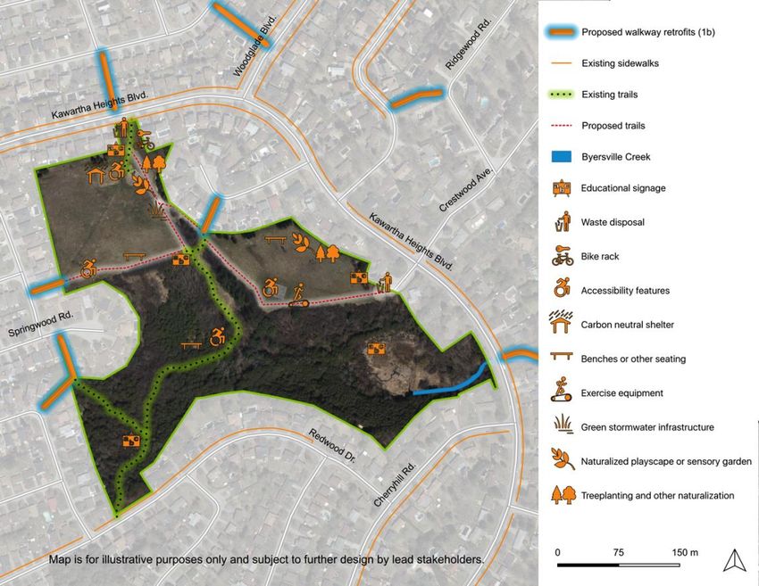
Energy and climate ..................................................................................................... 15

   Local food (secondary theme) .................................................................................. 15

A vision for Kawartha Heights ........................................................................... 16

   Toward an active, greener future – introduction .................................................... 16

   Vision components ..................................................................................................... 16

Focus area 1: Transform grey into green ......................................................... 18

   Vision............................................................................................................................ 18

   How do we get there?................................................................................................. 18

   Sustainability themes addressed ............................................................................. 24

Focus area 2: Build local capacity..................................................................... 25

   Vision............................................................................................................................ 25

   How do we get there?................................................................................................. 25

   Spotlight: Kawartha Heights Public School outdoor classroom and community
   space ............................................................................................................................ 27

   Sustainability themes addressed ............................................................................. 27

Focus area 3: Enhance local parks ................................................................... 28

   Vision............................................................................................................................ 28

   How do we get there?................................................................................................. 28

   Sustainability themes addressed ............................................................................. 30

Focus area 4: Travel sustainably ....................................................................... 32

   Vision............................................................................................................................ 32

   How do we get there?................................................................................................. 32

   Sustainability themes addressed ............................................................................. 35

Successes to date ................................................................................................ 36

   Summary ...................................................................................................................... 36

   Spotlight: Pollinator garden at APEX Cardiology ................................................... 36

                                                                  vi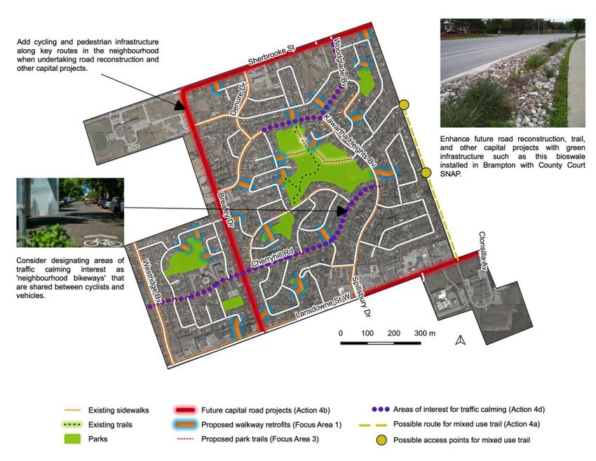
Next steps ............................................................................................................. 38

   Implementation ........................................................................................................... 38

   Reporting ..................................................................................................................... 38

References ............................................................................................................ 39

Appendices ........................................................................................................... 42

   Appendix A: Summary of engagement results for Kawartha Heights ................. 42

      Phase 1 engagement process .................................................................................. 42

      Engagement results by sustainability theme ............................................................ 45

      Phase 2 (2019) ......................................................................................................... 48

   Appendix B: Guidelines and criteria for selecting recommendations for the SUN
   Action Plans ................................................................................................................ 50

   Appendix C: Determining long-term outcomes ...................................................... 51

      Water ......................................................................................................................... 51

      Habitat and urban forest ........................................................................................... 52

      Healthy, active transportation ................................................................................... 54

      Community building .................................................................................................. 55

      Energy and climate ................................................................................................... 55

      Local food security (secondary theme) .................................................................... 56

   Appendix D: Summary of SUN Quick-Starts ........................................................... 57

                                                                 vii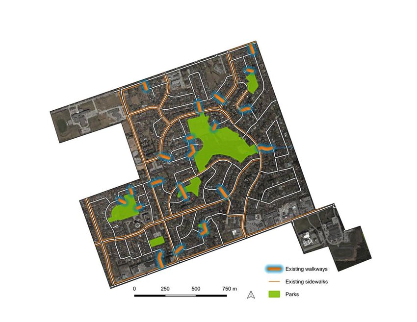
Executive summary

Toward an active, greener future

Kawartha Heights is a large, suburban neighbourhood at the westernmost edge
of the city of Peterborough. Residents appreciate its spacious feel, nearby
schools, and quiet atmosphere. Yet, like many urban communities today, the
neighbourhood is characterized by declining biodiversity, underused green
space, and car dependency. As climate change intensifies, it is more important
than ever that we reverse these trends and adapt to a warmer and less
predictable environment.

In 2017, Kawartha Heights was chosen as one of two pilot neighbourhoods for
the GreenUP Sustainable Urban Neighbourhoods program (SUN), a three-year
initiative that offers an innovative way of making the places we live, work, play,
and learn more sustainable and resilient to climate change.

The SUN approach builds widespread support for neighbourhood action by
bringing together residents, the municipality, and partners such as Otonabee
Conservation, Nourish, and others, to create an Action Plan tailored to each
community. Since 2017, our partners and hundreds of Kawartha Heights
residents and community members have identified local needs and shared their
ideas for neighbourhood projects and programs.

The Plan represents a collective vision of what the neighbourhood can become
by 2030 if actions are implemented swiftly and collaboratively, and provides a
roadmap for how to get there. Actions are grouped into four focus areas:

1. Transform grey into green enhances residential, institutional, and
   commercial properties through retrofits designed to increase biodiversity and
   urban forest canopy, improve stormwater management, support local food
   production, and reduce our collective carbon footprint.

2. Build local capacity increases the ability of residents and community groups
   to undertake action at home and in their neighbourhood through education,
   incentives, and more.

3. Enhance local parks maximizes the neighbourhood’s ample green space for
   multiple benefits, including more sustainable stormwater management,
   increased biodiversity and urban forest canopy, and greater opportunities for
   healthy recreation and community building.

4. Travel sustainably improves pedestrian and cycling infrastructure and
   connectivity, encourages residents to choose active transportation options,
   and maximizes proposed capital projects for additional outcomes like
   sustainable stormwater management.

                                        viii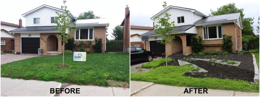
Each recommended action aligns with SUN’s core principles and supports the
long-term outcomes for two or more of the sustainability themes in Kawartha
Heights: water; habitat and urban forest; healthy and active transportation and
recreation; community building; energy and climate; and local food security. The
themes and outcomes align as much as possible with local, regional, federal, and
international plans, policies, and goals.

With the planning phases of the project complete, SUN and its partners will be
developing an implementation framework that identifies lead stakeholders,
supporting partners, and next steps for each action. To get involved, visit the
SUN website.

                                        ix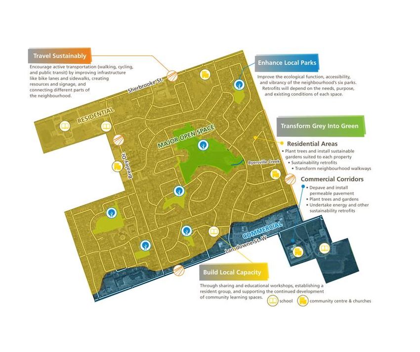
What is SUN?

Introduction
The Sustainable Urban Neighbourhoods program is a three-year initiative funded
by the Ontario Trillium Foundation and led by GreenUP. It offers an innovative
and collaborative way to transform the places we live, work, play, and learn,
making them more sustainable and resilient to the impacts of climate change.
SUN brings together local residents, municipal staff, community groups, and
other key partners to identify ideas and opportunities for change.

In addition to planning, SUN undertakes ‘Quick-start’ demonstration projects that
inspire residents, community groups, and partners to take action by showcasing
possibilities for change. Quick-starts are also opportunities for SUN to engage
with the wider community and build capacity amongst residents to support the
implementation of the Action Plan.

There are two kinds of Quick-starts: high intensity and low intensity actions. The
five kinds of high intensity planting options include urban tree planting, pollinator
gardens, rain gardens, food gardens, and native species plantings. Low-intensity
retrofit actions include removing invasive species, and providing rain barrels,
composters, bat houses, and birdhouses.

Sustainable Urban Neighbourhoods (SUN) is modelled after Toronto and Region
Conservation Authority’s Sustainable Neighbourhood Action Program (SNAP).
SNAP is a collaborative, neighbourhood-based solution for advancing
sustainable urban renewal and climate action in older urban areas. For more
information, visit TRCA’s SNAP website.

Governance structure
SUN’s work is supported and directed by the SUN advisory committee, which
consists of representatives from the following groups and institutions:

•   GreenUP
•   City of Peterborough
•   Otonabee Conservation
•   Toronto and Region Conservation Authority (TRCA)
•   Nourish Project
•   Peterborough Utilities Group (PUG)
•   Peterborough Public Health (PPH)
•   Peterborough Pollinators
•   Transition Town Peterborough
•   Fleming College
•   Trent University
•   The Canadian Canoe Museum

                                          1
• Kawartha Heights resident representative
• East City-Curtis Creek resident representative
The advisory committee has met six times to review program progress and
advise on community engagement strategies, Quick-start and educational
events, and the proposed content and format of the Neighbourhood Action Plan.
In addition to the advisory committee, the following local groups and
organizations have supported and participated in SUN Kawartha Heights:
• Local residents
• Schools (Holy Cross Secondary School, Crestwood Secondary School,
James Strath Public School, and Kawartha Heights Public School)
• Churches and faith groups (Westdale United Church and Calvary Church)
• APEX Cardiology
• Applewood Retirement Residence
• Mapleridge Recreation Centre
Program background and neighbourhood selection
SUN is modelled after the Toronto and Region Conservation Authority’s
Sustainable Neighbourhood Action Program (SNAP). SNAP is a collaborative,
neighbourhood-based solution for advancing sustainable urban renewal and
climate action in older urban areas. In 2017, GreenUP received a three-year
Grow Grant from the Ontario Trillium Foundation to bring the SNAP approach to
Peterborough, a mid-sized municipality outside the Greater Toronto and Hamilton
Area.
In 2017, GreenUP consulted with the City of Peterborough, Sustainable
Peterborough, Otonabee Conservation, the County of Peterborough, and Nourish
to identify priority areas for each partner. Next, GreenUP developed a
neighbourhood selection process adapted from the SNAP model, shortlisted five
neighbourhoods, and selected the final two pilot neighbourhoods. The criteria
used to select pilot neighbourhoods included:
• A minimum area of 1.5km2
• Known vulnerabilities to future climate change impacts (e.g. flood risk)
• Mixed land uses (residential, commercial, institutional, etc.)
• Existing participation in other community projects or initiatives
• Distinctive characteristics from other shortlisted neighbourhoods (e.g.
differences in demographics, density, rates of home ownership, etc.)
• Alignment with local and regional plans and priorities
• Potential to address multiple partner priorities within the neighbourhood
• Sufficient community readiness
2Kawartha Heights and East City–Curtis Creek were selected from a shortlist of
five potential neighbourhoods within the City limits, which also included
Bonaccord, Talwood, and the Downtown area. A separate report outlining the
neighbourhood selection process is available upon request.
Engagement process
The Neighbourhood Action Plan is based on input from local residents and other
community members, and aligned with the plans and priorities of partners such
as the City of Peterborough, Otonabee Conservation, and others. Overall,
GreenUP staff have recorded 1037 engagement interactions with people who
live, work, play, and learn in Kawartha Heights neighbourhood, and held twenty-
two meetings with partner representatives. There have been two phases of
engagement toward the Action Plan.
Phase 1 (2017–2018)
From late 2017 to late 2018, SUN program staff undertook extensive partner and
resident engagement to expand knowledge on local baseline conditions and
learn about opportunities and priorities in each neighbourhood. Partners were
engaged through five joint advisory committee meetings, a partner questionnaire
completed by seven partner representatives, and a series of one-on-one
meetings and phone calls between SUN program staff and partner
representatives.
An important component of the SUN model is identifying alignments between
municipal capital projects and planning opportunities and the needs and interests
of the local community. In Kawartha Heights, the following municipal and/or joint
stakeholder projects and initiatives have been identified as opportunities to
pursue long-term sustainability objectives identified in this Action Plan.
Capital projects
• Brealey Drive reconstruction: Pending budget approval, this future project
will continue the reconstruction of Brealey Drive between Lansdowne Street
West and Sherbrooke Street. It will install and improve cycling and pedestrian
infrastructure, and install additional stormwater management infrastructure in
the form of curbs and gutters.
• Lansdowne Street West improvements: This future project will improve
traffic capacity between Clonsilla Avenue and Spillsbury Drive, and construct
a centre turning lane.
• Holy Cross Field Rehabilitation Project (2019): This project is a
collaborative effort between the City of Peterborough and the Peterborough
Victoria Northumberland and Clarington Catholic District School Board to
upgrade the existing natural sports fields to an artificial turf at Holy Cross
Secondary School for community and school board use.
3• Sherbrooke Street reconstruction and widening: This future project will
install and improve pedestrian and cycling infrastructure and stormwater
management infrastructure from Glenforest Boulevard to the western city
limit.
Planning and policy projects
• Municipal Parks and Open Space Review (2018–2019): The key objectives
of this review are to establish planning and design guidelines for parks,
evaluate existing parks and identify those requiring improvement, and identify
and address gaps in access to neighbourhood parkland (City of
Peterborough, 2019).
• Our Watershed, Our Blueprint (2019–2021): The key objective of this
municipal project is to provide a framework to assist the City in the protection
and management of water resources.
• City of Peterborough Official Plan (2020): In 2011, the City of Peterborough
began preparing a new Official Plan to direct municipal growth and operations
until 2041. At the time of writing, the draft Official Plan was made available to
the public for review.
• Transition 2050 (2019–2021): In 2019, TRCA received funding from the
Federation of Canadian Municipalities to work with nine municipalities,
including Peterborough, as they develop residential- and/or business-focused
climate action plans at the neighbourhood level. The lessons learned from
this collaborative initiative will help to refine, mainstream, and scale TRCA’s
neighbourhood model as a means of implementing climate action plans and
achieving other municipal and regional objectives. There may be
opportunities to connect this initiative with the work already underway in the
SUN neighbourhoods.
GreenUP staff engaged the neighbourhood in five main ways during Phase 1: (1)
one-on-one meetings; (2) online surveys; (3) Quick-start garden installation
events; (4) outreach and educational events organized through the SUN program
(such as ‘planning potlucks’ and ‘kitchen table conversations’); and (5) tabling at
events organized by others in the community.
Notes from these engagement opportunities were coded using tags such as
‘flooding,’ ‘biodiversity,’ or ‘pedestrian safety’. These codes were then used to
determine the top sustainability themes or priorities for each neighbourhood,
which are outlined in Sustainability Themes and Long-Term Outcomes.
Phase 2 (2019)
In 2019, SUN shifted from general engagement about sustainability priorities,
needs, and opportunities in Kawartha Heights to soliciting specific action and
program suggestions for the Action Plan.
4SUN organized two Action Plan Gatherings in early 2019 to solicit input from
residents and partners. The first of these took place on January 23 2019 at the
McDonnel Street Activity Centre. This event brought together 45 participants who
represented partners and residents from both SUN neighbourhoods. Nine
attendees were residents and/or community representatives from Kawartha
Heights. Ideas for the Action Plans were generated through a series of
interactive, small-group activities designed by Christie Nash, a local consultant
with expertise in conducting community engagement and event facilitation.
A second follow-up Gathering was held in the neighbourhood on March 22 2019.
Twenty-two residents and community members attended. This event combined a
free dinner, child-friendly entertainment, and drop-in style Action Planning
activities. The goal was to build on the ideas identified during Phase 1 of
engagement and at the Action Plan Gathering in January. GreenUP staff invited
residents to provide feedback on proposed ideas, and to suggest additional ones.
Data was captured using modified versions of the activities developed for the first
Gathering.
A full report on data collected at these two Gatherings is available upon request.
Once a list of potential actions and program ideas was established, GreenUP
staff grouped them into focus areas using an inductive approach, and compared
these with categories recommended by the consultant in her final report. Next,
each action was assessed according to SUN advisory committee criteria to
determine whether it should be included in the Action Plan. Ideas that met the
greatest number of criteria were included. In some cases, actions were merged
and/or modified to better suit local conditions and opportunities, reflect best
practices and scientific knowledge, or better align with partner priorities in the
neighbourhood. See Appendix B: Guidelines and Criteria for Selecting
Recommendations for the SUN Action Plans for further details.
Since June 2019, GreenUP staff have been soliciting resident and partner
feedback on the first draft of the Neighbourhood Action Plan. For an extended
summary of the engagement results, see Appendix A: Engagement Summary for
Kawartha Heights.
5Neighbourhood overview
Figure 1. Location and boundaries of Kawartha Heights. Image by GreenUP.
Introduction
Kawartha Heights is a large suburban neighbourhood at the westernmost edge of
the city. It is bounded by Sherbrooke Street in the north, Kawartha Golf and
Country Club in the east, Lansdowne Street West in the south (including Holy
Cross Secondary School and Calvary Church), and Westridge Boulevard and
Brealey Drive in the west (including James Strath Public School and Crestwood
Secondary School).
6The area was once a diverse landscape of forests and wetlands that were
shaped and cared for by the Michi Saagiig Nishnaabeg. In the nineteenth
century, European settlers took the land and cleared it for agriculture, especially
dairy and fruit production. The neighbourhood was established after the area was
annexed by the City of Peterborough in 1963. Seventy-five per cent of the homes
were constructed between 1961 and 1990 (Government of Canada, 2016).
Today, the neighbourhood boasts six parks. The largest of these, spanning an
impressive eleven hectares, is Kawartha Heights Park, which residents describe
as a ‘neighbourhood gem.’ Most of the neighbourhood falls within the Byersville-
Harper Creek watershed, which is home to one of the city’s last remaining
provincially-significant wetlands. Because of the neighbourhood’s size, position,
and topography, it has an important role to play in maintaining the ecological
well-being of the watershed, reducing flooding in neighbourhoods downstream,
and expanding the urban forest.
Summary of neighbourhood baseline conditions
Soil, topography, and water
The 248-hectare neighbourhood of Kawartha Heights is located at one of the
highest points in the City. It has a peak elevation of approximately 270–280m
above sea level in the north end, falling to approximately 200m above sea level
near Lansdowne Street West.
The predominant soil types found around the Byersville-Harper Creek watershed
are Otonabee loam and Bondhead sandy loam, both of which are fast draining
soil types that minimize run-off and support the growth of a wide variety of plant
and tree species (Gillespie and Acton, 1981, cited in XCG Consultants, 2009).
Nearly the entire neighbourhood falls within the Byersville-Harper Creek
watershed, a 1,200 hectare area that encompasses a provincially significant
wetland in Harper Park.1 The majority of Byersville Creek lies beyond the
Kawartha Heights neighbourhood, except for a section of the west branch that
originates in present day Kawartha Heights Park, and flows eastward underneath
residential streets before continuing above ground through the Kawartha Golf
and Country Club property.
1The only exceptions are part of the property of James Strath Public School and the entirety of
Crestwood Secondary School, in the western section of the neighbourhood.
7Figure 2. Map showing aerial imagery of Kawartha Heights in 1959 with 2018
impermeable surface area overlay.
Due to extensive suburban and commercial development, approximately 44% of
the total surface area in Kawartha Heights is now impermeable (Figure 2), while
imperviousness for the entire Byersville-Harper Creek watershed is estimated at
37.5% (XCG, 2009). Both values exceed the recommended maximum of 10%
imperviousness in urbanized watersheds; stream quality is typically “severely
impaired” once an urban watershed exceeds 30% (Environment Canada, 2013,
p. 53).
Impermeable surfaces do not absorb rainwater, which becomes run-off that must
be managed through the municipal stormwater system. Too much run-off
disrupts the natural water balance, reduces water quality, and can cause
localized urban flooding. The City of Peterborough’s Stormwater Quality Master
Plan Project Report found that Byersville Creek experiences higher than
recommended levels of aluminium, copper, iron, lead, zinc, total phosphorous, E.
coli, and total suspended solids during wet weather events, which suggests that
urban stormwater run-off is having a negative impact on water quality (XCG
Consultants, 2014). During the 2004 flood, the culvert inlet in Kawartha Heights
Park backed up, which redirected run-off onto Kawartha Heights Boulevard and
caused flood damage on nearby private properties.
8Urban forest, habitat, and wildlife
Urban forest canopy in Kawartha Heights neighbourhood is estimated at 28%
based on 2015 aerial analysis, which is less than the estimated citywide
coverage of 29% in 2011. Canopy cover levels differ by land use type. Canopy
cover in local parks and other open spaces is estimated at 68%, and 24% in
residential and commercial areas (Sandanayake, 2019). Kawartha Heights Park
contains some unique heritage trees, including a large red oak near the
Byersville Creek culvert (Loucks, 2013).
The municipality recommends that no single genus represent more than 20% of
the urban forest canopy (City of Peterborough, 2011). Maples make up 57% of
the existing City-owned trees in the neighbourhood, with the ash genus being the
next most common at 9.55%. Although this data does not include privately
owned trees, it is safe to assume that biodiversity in the Kawartha Heights urban
forest can be improved, which will make it more resilient to the impacts of climate
change and destructive pests and diseases. Many City-owned ash trees are
already threatened by the emerald ash borer; of the 191 local ash trees
inventoried by the municipality in 2019, 58% (n=110) are being treated for ash
borer, 3% (n=6) are being monitored for size, structure, and health, and 39%
(n=75) are slated for removal and replacement with non-ash species (City of
Peterborough, 2019c).
Data on wildlife and vegetation within the neighbourhood is limited. However,
Gray Owl Environmental Inc. undertook wildlife surveys and vegetation
community mapping in 2007 in connection with the Flood Reduction Master Plan
for Byersville-Harper Creek (XCG Consultants, 2009). In Kawartha Heights Park
they observed three dragonfly species, eight butterfly species (including
monarchs, a species of special concern in Ontario), three frog species, eight
mammals, and thirty-five bird species. One of the bird species observed was the
eastern wood peewee, which was not considered a species at risk at the time but
was listed as a species of special concern in 2014 (MNRF, 2018). The XCG
study also found a total of 171 species of vegetation, 107 of which (63%) were
native species (Gray Owl Environmental Inc., cited in XCG Consultants, 2009).
Seventeen of the species recorded have high potential invasiveness. Overall, the
plant community in Kawartha Heights Park had a mean coefficient of
conservatism of 3.2, and a Floristic Quality Index (FQI) value of 32 (Gray Owl
Environmental Inc., cited in XCG Consultants, 2009). The report explains: “the
flora indicates an area that is moderately disturbed, but generally of much higher
quality than most urban parks” (Gray Owl Environmental Inc., cited in XCB
Consultants, 2009).
Demographics and community values
In 2016, there were 5434 people living in Kawartha Heights. The age distribution
is similar to the City of Peterborough, with a slightly higher proportion of seniors
living in Kawartha Heights (see Table 1).
9Table 1. Percentage of residents in Kawartha Heights by age group, compared
to City of Peterborough.
Neighbourhood 0 to 14 15 to 65 Total
years 64 years %
old years and
old over
Kawartha 14 61 25 100
Heights
City of 15 63 22 100
Peterborough
Source: Government of Canada, 2016.
Kawartha Heights is a relatively high-income area, with 65% of households
earning $60,000 or more, compared to just 49% of households in the city as a
whole (see Table 2). Seventy-nine per cent of households in Kawartha Heights
owned their homes in 2016. The remaining 21% rented (Government of Canada,
2016). People who rent likely include predominantly post-secondary students
given the proximity of the neighbourhood to Fleming College.
According to Manifold Data Mining Inc. (2019), a data analysis firm that provides
neighbourhood data, nearly one-fifth of the families living in Kawartha Heights
are characterized as ‘Nest Builders,’ white-collar families with an interest in home
and garden renovations. Another 20% of families work in the skilled trades and
have interests in natural health, renovations, hunting, and fishing. These two
types of households may take an interest in home and garden retrofit projects
proposed by SUN.
Table 2. Percentage of households in Kawartha Heights by income bracket,
compared to city of Peterborough.
10Neighbourhood Under 20k– 40k– 60– 80– 100k Total
20k 39k 59k 79k 99k and %
over
Kawartha 4 14 16 18 13 34 99
Heights
City of 12 21 18 14 11 24 100
Peterborough
Source: Government of Canada, 2016. Note: percentages may not equal 100
due to rounding.
Built environment
Land use in Kawartha Heights consists of residential areas (88.6%), commercial
areas (6.8%), and major open space and protected natural areas (4.6%).
The majority of residences in the neighbourhood are detached, single-family
dwellings, 75% of which were constructed between 1961 and 1990 (Government
of Canada, 2016). There are also low-rise residences in the form of apartment
buildings, condominiums, and retirement residences. See Table 3 for a
breakdown of dwellings by type.
Table 3. Percentage of dwellings by type
Single Semi- Row Apartment Apartment Apartment
detached detached house in a flat or in building in a
duplex more than building
five less than
storeys five
storeys
73% 5% 4% 6% 2% 11%
Source: Government of Canada, 2016.
Many residences in the neighbourhood reflect the typical aesthetic of a maturing
suburban neighbourhood, with multi-car garages, large lawns, and well-kept
ornamental landscaping. The average lot size in Kawartha Heights is 721m2.
While researching the neighbourhood during the summer and fall of 2017,
11GreenUP staff noted the presence of several landscaping company vehicles
within the neighbourhood. Due to the neighbourhood’s topography, low canopy
cover in residential areas, and quick-draining soil, many residents have difficulty
maintaining their lawns and gardens during summer droughts, and as a result,
increase outdoor potable water use.
Transportation
Kawartha Heights is a car-dependent neighbourhood. Only 7% of people aged
15 years and over with a usual place of work use active transportation methods
to commute to work (Government of Canada, 2016). Fifty-two per cent of
residents (n=1340) report commute times of less than fifteen minutes, which
suggests that a greater number could likely walk, cycle, or take transit to work
(Government of Canada, 2016). There are two Fleming Express bus routes that
service the area and three regular City bus routes. Residents report that the most
frequent users of public transit are Fleming College students, people with
disabilities, and seniors who do not drive.
Segments of major transportation corridors, including Sherbrooke Street, Brealey
Drive, and Kawartha Heights Boulevard, lack consistent, accessible sidewalks,
although the municipality improved the accessibility of bus stops and curbs along
Kawartha Heights Boulevard in 2018. At the time of writing, bike lanes exist along
Lansdowne Street West between Spillsbury Drive and Brealey Drive, and the
sidewalk along the south side of Lansdowne Street West between Spillsbury
Drive and Clonsilla Avenue is a shared pedestrian-bicycle pathway. However,
there are no bicycle lanes on other streets in the neighbourhood. Other barriers
to choosing active transportation include the distance of Kawartha Heights from
downtown Peterborough, the neighbourhood’s topography, and cultural factors
such as the prevalence of car travel in suburban society.
Parks and other community services
Kawartha Heights neighbourhood (KH) contains six parks: Kawartha Heights,
Mapleridge, Dainard, Applewood, Redwood, and Oakwood. The largest of these,
Kawartha Heights Park, is appreciated by residents for its size and informal
forested walking trails. Mapleridge Park is designated as a natural protected area
by the municipality. Despite significant access to parkland for recreational
purposes, residents note that some parks lack vibrancy and are underused due
to lack of shade or amenities.
Commercial businesses are concentrated along the Lansdowne Street West
corridor, which is one of the busiest streets in the city. There are large box
stores, car dealerships, and strip mall plazas with ample parking lots. There is a
smaller pocket of commercial development along Sherbrooke Street in the north
end of the neighbourhood.
12There are four schools located within the neighbourhood, including Crestwood
Secondary School, James Strath Public School (K–8), and Kawartha Heights
Public School (K–6) in the Kawartha Pine Ridge District School Board
(KPRDSB), and Holy Cross Secondary School in the Peterborough Victoria
Northumberland and Clarington Catholic School Board (PVNCCDSB). Residents
have identified the proximity of schools as a significant asset to the
neighbourhood, including Fleming College, a post-secondary institution located
just south of the neighbourhood.
There are two recreational facilities or community centres located within or near
the neighbourhood: Mapleridge Recreation Centre for seniors, located on the
west side of Brealey Drive, and the Peterborough Sport and Wellness Centre,
just south of Lansdowne Street West.
Additionally, there are several faith institutions in the neighbourhood: Westdale
United Church, Ferndale Bible Church, and Calvary Church. Sherbrooke Heights
Alliance Church is located just north of the neighbourhood on Sherbrooke Street
West.
13Sustainability themes & long-term outcomes
SUN identified the following sustainability priorities for partners and residents
during Phase 1 of the engagement process. There are five priority themes and
one secondary theme in Kawartha Heights. The themes are described below,
along with long-term outcomes for each. As much as possible, these outcomes
align with municipal and regional level goals, plans, and targets. All targets are
set for 2030, unless otherwise indicated. An explanation of how each target was
generated is available in Appendix D: Determining Long-Term Outcomes.
Water
The water theme includes water conservation, riverine and urban flooding,
management of the municipal stormwater system, and the ecological well-being
of the Byersville-Harper Creek watershed. Long-term outcomes include:
Improvements to permeability, watershed health, and local flooding by:
• Reducing paved surface area by 1750m2 (0.175ha), from the 2018 baseline of
101.1ha impermeable surface area (44% of total area);
• Increasing the amount of rainwater managed where it falls on residential,
institutional, and commercial properties. Work toward the 90% runoff volume
control target recommended by the Ministry of Environment and Climate
Change (now Ministry of the Environment, Conservation, and Parks) in 2016,
which equals the first 27mm of an average rain event in Peterborough;
• Improvements to water quality in Byersville Creek from baseline reported in
the City of Peterborough’s Stormwater Quality Master Plan (2014).
Habitat and urban forest
Habitat and urban forest includes the biodiversity and well-being of natural
ecosystems in the neighbourhood. Long-term outcomes include:
• Expansion and diversification of the urban forest canopy by planting 1279
new trees, with 685 on residential properties. Prioritize, where appropriate,
underrepresented species recommended by the municipality;
• Greater biodiversity, by creating 2500 square metres of habitat for pollinators
and other wildlife, which is equivalent to 5.7 NBA basketball courts.
Healthy, active transportation and recreation
Healthy, active transportation and recreation includes the ways we travel to and
through the neighbourhood, the kinds of recreation activities that are available to
local residents, and the growth and development of healthy people. Long-term
outcomes include:
14• Twelve per cent of Kawartha Heights residents commuting by public transit,
walking, or cycling (from 7% in 2016), by enhancing active transportation
infrastructure and supporting residents to choose active transportation
options;
• Enhancement of local outdoor spaces for inclusive and healthy recreation,
with 100% of local parks meeting or exceeding the minimum required design
features for each park type as identified in the Municipal Parks and Open
Space review.
Community building
Community building includes connections between community members
(including local institutions like schools and faith groups), and general
neighbourhood identity. Long-term outcomes include:
• Greater sense of community belonging among residents, measured through
qualitative feedback and/or survey data, where available;
• Greater environmental awareness and capacity for local environmental
action, to be achieved by increasing the number of environmental events,
initiatives, and participants each year.
Energy and climate
Energy and climate includes how we heat and power our homes, schools, and
businesses on a daily basis, and the greenhouse gases (GHGs) we produce
through travel and waste. Long-term outcomes include:
Progress toward the Climate Change Action Plan target of reducing community
greenhouse gas emissions 30% by 2031 (Sustainable Peterborough, 2016), to
be achieved by:
• Implementing energy efficiency and conservation retrofits at 40% of
residences (approximately 800 dwellings);
• Implementing energy efficiency and conservation retrofits in 60% of industrial,
commercial, and institutional facilities in the neighbourhood.
Local food (secondary theme)
Local food refers to food that is produced and consumed locally. To ensure
greater food security, local food should be widely available, affordable, nutritious,
and culturally appropriate. Long-term outcomes include:
• Greater number of residents producing some of their own food at home or
through community gardens.
15A vision for Kawartha Heights
Toward an active, greener future – introduction
The year is 2030. Kawartha Heights has been transformed into a sustainable and
resilient urban neighbourhood that maximizes its ample space and people power
to achieve its goals. Residents are confident in their ability to weather the storms
created by climate change—both literal and figurative—and quick to implement
projects that improve their resiliency. Their success has inspired other
neighbourhoods, and helped the municipality and other partners achieve their
climate change targets too.
Swift collective action has changed what it means to live, work, play, and learn in
Kawartha Heights. Urban nature is treated as a friend, an ethic demonstrated by
the richness and diversity of neighbourhood forests and gardens, the health of
the local watershed, the number of people who cycle and walk on a daily basis,
and residents’ knowledge and connection to their local environment.
Vision components
Over the next ten years, residents, community groups, partners, and the
municipality can make this vision a reality by concentrating on four focus areas:
1. Transform grey into green transforms residential, institutional, and
commercial properties through retrofits designed to increase biodiversity and
urban forest canopy, improve stormwater management, support local food
production, and reduce our collective carbon footprint.
2. Build local capacity increases the ability of residents and community groups
to undertake action at home and in their neighbourhood through education,
incentives, and more.
3. Enhance local parks maximizes the neighbourhood’s ample green space for
multiple benefits, including more sustainable stormwater management,
increased biodiversity and urban forest canopy, and greater opportunities for
healthy recreation and community building.
4. Travel sustainably improves pedestrian and cycling infrastructure and
connectivity, encourage residents to choose active transportation options, and
maximize proposed capital projects for additional outcomes like sustainable
stormwater management.
The actions recommended in the four focus areas reflect the following principles:
• Collaborative: they rely on and benefit from involvement of multiple
stakeholders.
16• Multipurpose: they connect to multiple sustainability themes.
• Measurable: their impact on the environment and/or community is
measurable
• Innovative: they build on the natural assets, local character, and unique
opportunities available in the neighbourhood.
• Inspirational: they inspire others to take action.
Figure 3. Visualization of the overall vision for Kawartha Heights. Icons and text
by Frolic Design.
17Focus area 1: Transform grey into green
Vision
In 2030, diverse front yard gardens define this suburban neighbourhood. Regular
tree planting connects formerly isolated pockets of trees into an urban forest that
delights residents and visitors with its diversity of colours, shapes, sounds, and
smells. Retrofits to buildings and open land have transformed Kawartha Heights
into a model for managing rainwater and energy. The benefits of these changes
to the Byersville-Harper Creek watershed are celebrated throughout the city.
How do we get there?
Recommended actions include:
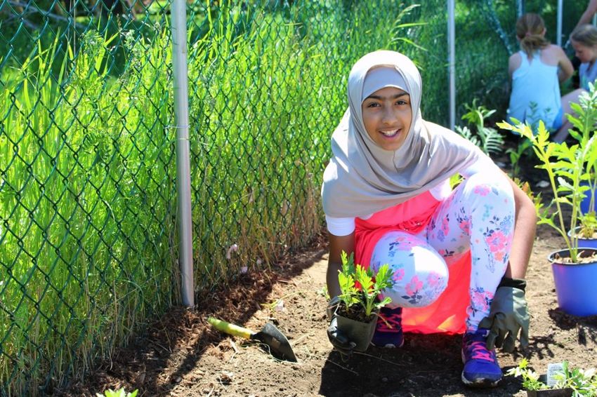
1a. Delawn at homes, schools, churches, and businesses in favour of
planting trees and installing pollinator, rain, drought-tolerant, and food
gardens. This action should be led by residents, community and faith
groups, schools, businesses, and non-governmental organizations.
Many residential, commercial, and institutional properties in Kawartha Heights
have large lawns that could be planted with trees and gardens that provide
greater ecological benefits, while also increasing aesthetic diversity in the
neighbourhood. Delawning projects should be designed based on site conditions,
resident or property owner interest and capacity, and their potential
environmental impact. This action will continue the progress made through the
SUN Quick-start demonstration gardens that were installed in 2018 and 2019.
For example, transforming lawns into drought tolerant gardens would address the
challenge many Kawartha Heights residents face in maintaining healthy lawns
during summer droughts. Currently, many residents rely heavily on potable water
to water their lawns during the summer months. Converting all or part of a lawn
into a drought tolerant garden can reduce residential water bills while helping
rainwater soak into the ground and provide habitat for native pollinators and other
wildlife.
18Figure 4. Before and after photos of a Water Wise residential delawning project
in Kawartha Heights. Drought tolerant gardens like this one, installed by SUN in
2018, can enhance the curb appeal of your property while creating significant
environmental benefits. Photos by GreenUP.
Rain, pollinator, and food gardens are other lawn replacement possibilities in this
neighbourhood. Rain gardens and soakaways are examples of green
infrastructure that help slow and reduce stormwater run-off. They may be
appropriate for sites that meet the minimum requirements in terms of space, soil
type, and slope.
Pollinator gardens are designed to provide habitat and food for a range of native
pollinator species such as bees and butterflies. These gardens are often colourful
and vibrant. A pollinator garden inventory in the neighbourhood, similar to one
conducted by Peterborough Pollinators and SUN in East City-Curtis creek in
2018, would identify areas of the neighbourhood with the greatest need for more
pollinator habitat.
Food gardens are ideal for residents who wish to reduce the amount of food they
need to purchase, or who want better access to fresh, nutritious, and culturally
appropriate produce. While they typically require more labour and inputs than
other types of landscaping, food gardens that are watered using rainwater,
mulched to improve water conservation, and fertilized using compost can be
quite environmentally sustainable. In general, food gardens require at least six to
eight hours of sunlight a day, and may not be appropriate for residential
properties with extensive shade.
Urban canopy cover outside parks and other open space is just 24% in Kawartha
Heights. Many residential lots are of sufficient size to support one or more urban
tree. SUN estimates that residential properties could support an additional 685
trees, but further technical analysis is required to refine these recommendations
and identify ideal locations. For an explanation of how this number was
calculated, see Appendix C: Determining Long-term Outcomes.
19Delawning projects need not be limited to residential properties. There are
schools, businesses, and churches in the neighbourhood with extensive grass
areas that could also be transformed. In many cases, these types of properties
have larger spaces than homeowners, which means their impact would be more
significant.
1b. Transform the neighbourhood’s pedestrian walkways into inviting
green corridors using pollinator gardens, tree planting, stormwater
bioswales, educational signage, seating, and art. This action could be led
by the municipality, Otonabee Conservation, and non-governmental
organizations.
Kawartha Heights neighbourhood has twenty pedestrian walkways that connect
different residential areas in the neighbourhood (Figures 5). They are located:
• Between Sherbrooke Street and Sunnylea Street
• Between Sherbrooke Street and Ridgewood Road
• Between Ridgewood Court and Ridgewood Road
• Between Lynhaven Road and Woodglade Boulevard
• Between Lynhaven Road and Kawartha Heights Boulevard
• Between Oakwood Crescent and Ridgewood Road
• Between Bayleaf Court and Kawartha Heights Park
• Between Wintergreen Trail and Kawartha Heights Park
• Between Springwood Road (south branch) and Springwood Road (north
branch)
• Between Springwood Road and Kawartha Heights Boulevard
• Between Beechwood Drive and Kawartha Heights Boulevard
• Between Renforth Court and Brealey Drive
• Between Redwood Drive and Redwood Court (through Redwood Park)
• Between Treetop Road and Cherryhill Road
• Between Applewood Court and Stewartcroft Crescent (through Applewood
Park)
• Between Stewartcroft Crescent and Brealey Drive
• Between Mapleridge Drive and Mapleridge Park (east branch)
• Between Mapleridge Drive and Mapleridge Park (west branch)
• Between Brimwood Crescent and Mapleridge Park
• Between Clearview Drive and Lansdowne Street West
These walkways are typically asphalt paths edged with grass when they could be
enhanced to fulfill a range of ecological and social needs (Figure 6). SUN
recommends that the municipality collaborate with other organizations and the
community to design retrofits that are appropriate to each site and reflect the
interests of nearby residents, schools, or community groups, who could assist
with maintenance of these spaces by ‘adopting’ them.
20Figure 5. Map of walkway locations in Kawartha Heights.
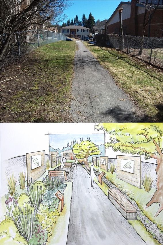
21Figure 6. Existing walkway between Redwood Drive and Redwood Court (top)
and a concept design for a retrofit of this location (bottom). Rendering is for
illustrative purposes only and subject to further design by lead stakeholders.
Photo by GreenUP and illustration by Dawn Pond.
221c. Retrofit homes, schools, churches, and businesses for greater
sustainability by improving insulation, installing new windows, installing
rain barrels and grey water systems, and more. This action should be led
by residents, the municipality, businesses, schools, community and faith
groups, and non-governmental organizations.
Energy and water conservation are key goals for Sustainable Peterborough, the
municipality, and local residents. Peterborough’s Climate Change Action Plan
has set a goal of a 30% reduction in community greenhouse gas emissions by
2031 (Sustainable Peterborough, 2016). Achieving this goal will require action on
a number of fronts, including improvement of energy efficiency in homes and
businesses.
Single, detached homes are the dominant type of residence in the
neighbourhood. Many of them were constructed between the 1960s and the early
1990s. Typically, houses in climates similar to Peterborough benefit from
improved insulation and draft proofing. However, further technical analysis is
required to identify the greatest opportunities for improvements in energy
efficiency and conservation in the average Kawartha Heights home.
One of the specific strategies identified in the Climate Change Action Plan is to
retrofit 40% of homes by 2031, with an emphasis on older homes where potential
gains are most significant (Sustainable Peterborough, 2016). In Kawartha
Heights, 40% of homes constructed between before 1990 would equal nearly
700 dwellings. A dedicated home retrofit program operated by the municipality
and/or a local non-profit organization would be an excellent way to encourage
and support residents to take action on the scale required to reach this target.
1d. Transform commercial areas along Lansdowne Street West from grey
to green with depaving projects, tree planting, permeable pavement, and/or
other green infrastructure. This action should be led by businesses and
non-governmental organizations.
Technical analysis shows that commercial properties along Lansdowne Street
West have a total impermeable surface area of 77%, well above the 44% ratio for
the neighbourhood as a whole (City of Peterborough, 2019). These properties
present significant opportunities for increases in permeability, canopy cover, and
biodiversity. The property on the northeast corner of Lansdowne Street West and
Kawartha Heights Boulevard, where the parking lot is generally underused, could
be a good candidate for replacing sections of asphalt with permeable pavement,
rain gardens, bioswales, and trees, where appropriate. See Figure 7 for an
example of a retrofit in a commercial parking lot.
23You can also read


