Keeping the North East Moving - Sixty Years of - CIHT
←
→
Page content transcription
If your browser does not render page correctly, please read the page content below
THE CHARTERED
 INSTITUTION OF HIGHWAYS
 & TRANSPORTATION

Sixty Years of
Keeping the
North East Moving
THE CHARTERED
INSTITUTION OF HIGHWAYS
& TRANSPORTATION

The A69 Carlisle to
Newcastle DBFO

      In the 1990s the Highways Agency devised a
      system called Design, Build, Finance and
      Operate (DBFO) whereby a private company
      would be appointed to operate and maintain a
      specified route for 30 years on the basis of an
      agreed financial arrangement. The DBFO
      schemes usually included the construction of a
      major improvement scheme that had been
      prepared ready for construction.

                                                        1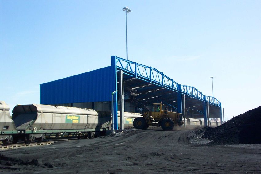
What is DBFO?
The Highways Agency formally launched its use of the Private Finance
Initiative (PFI) to procure road services on various parts of the
motorway and trunk road network in August 1994. These contracts
were known as Design, Build, Finance and Operate (DBFO) Contracts.

The method generally used by the Highways Agency for procuring
construction and maintenance of a road was to let contracts for separate
tasks. For example, there would be a design agent, a contractor and a
maintenance agent. Although each party performed its specified task
efficiently, there was little incentive for the parties to collaborate to
maximise overall value for money for the Highways Agency.

Furthermore, previously unknown factors tended to have a financial
impact and as a result there was often a significant increase between the
tendered cost and the final out- turn cost of a project. However, with the
introduction of DBFO Contracts there was now the opportunity to
transfer the responsibility for designing, constructing, financing and
operating a length of motorway or trunk road to a single DBFO
company.

The DBFO company could consider its obligations over the full life of
the contract, usually 30 years, taking account of all the risks inherent at
each stage of the project. By transferring these risks to the DBFO Co
there were now very few circumstances in which the Highways
Agency’s liabilities could be increased and this provided them with an
accurate, predictable spend profile for a given section of road over a
30-year period.

The first DBFO Contract awarded was for the A69 Carlisle to
Newcastle, to a private company called Road Link (A69) Ltd. The
Contract commenced on 1 April 1996 and will end on 31 March 2026.

                                                                              2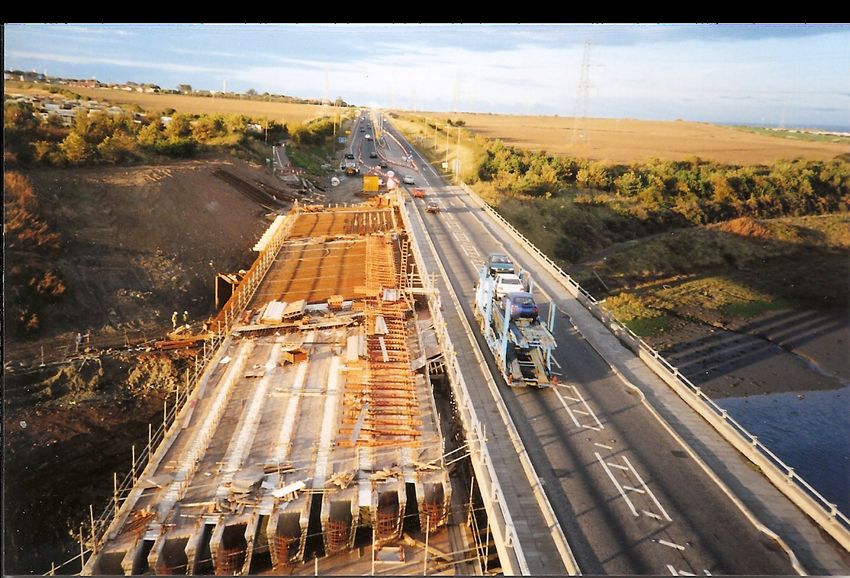
It included the construction of the Haltwhistle Bypass and its
subsequent operation and maintenance, together with maintenance of
the rest of the 52-mile long route between Carlisle and Newcastle for
the 30-year period.

Shadow Tolling
In accordance with the terms of the DBFO Contract, the Highways
Agency pays Road Link (A69) Ltd a fee, which is based on the number
of vehicles using the road. These payments are known as shadow tolls
(as opposed to real tolls), as payment for road usage is made by the
Highways Agency rather than by the road user. There are some
adjustments made for safety performance and lane closures.

Shadow tolls involve a payment per vehicle using a section of the A69
road, in accordance with a payment structure agreed at contract award.
The shadow tolls increase over time in accordance with an agreed
indexation formula. Different payments are due for traffic within
different traffic bands and these payments also vary depending on the
length of the vehicle.

                                                                         3
The A69 has been divided into 13 links for the purpose of counting the
traffic and determining the shadow tolls. The toll rate reduces as the
numbers of vehicles increase. The top rate is set at zero and therefore
the maximum liability for the Highways Agency is capped. As you
would expect, the traffic counters detect vehicle numbers to a high
degree of accuracy and are available 24 hours per day, 365 days per
year. The counters will remain in position for the 30-year contract
period.

The Haltwhistle Bypass scheme had been prepared by the Highways
Agency and their consultants for the scheme by conventional
procedures to the point that only the construction of the works was
required. As an incentive for Road Link to complete the construction as
early as possible in the 30-year DBFO contract, the shadow toll
payments were initially set at a much-reduced level. In this case the
A69 shadow tolls were set at 50% but then increased to 100% on
completion of the bypass.

Road Link started construction of Haltwhistle Bypass on 1 April 1996
and completed the works on 22 May 1997. The works involved the
construction of a 3.2km single carriageway to the souutharound the
town of Haltwhistle.

                                                                          4
The Highways Agency’s programme for the scheme was 18 months and
Road Links original programme was 16 months. However, once work
started and with the incentive of receiving the full toll payments on
completion of the works Road Link were able to accelerate the works
and complete the scheme in just under 14 months. This provided
benefits to the people of Haltwhistle with the early opening of the
bypass as well as significantly reducing the overall disruption to road
users while the works were taking place.

Performance
In addition to the shadow toll payment there are also two aspects in
connection with performance payments.

Safety Performance Payments – One of the key objectives of the
Highways Agency is to reduce accident levels on the trunk road
network. Road Link was therefore encouraged to identify safety
improvement schemes on the A69 and submit details to the Highways
Agency for approval. Accidents where personal injury occurs have a
recognised economic cost to the community at large and this provides a
mechanism for funding.

                                                                          5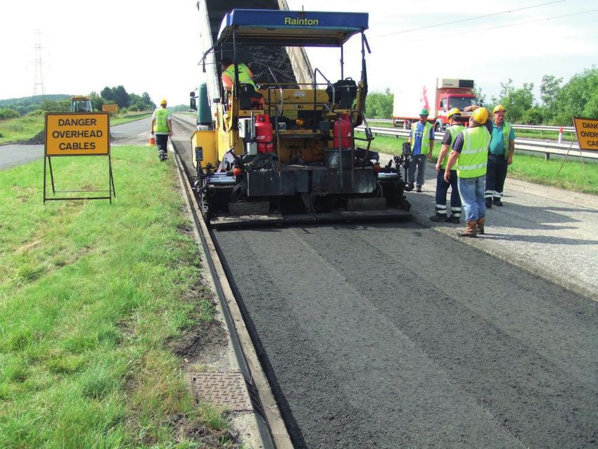
Where a scheme to improve safety is approved, Road Link constructs
and pays for the scheme and is recompensed by receiving a proportion
of the economic cost of each personal injury avoided in the following
5-year period. Accidents avoided are determined by comparing the
actual statistics with data over the 3-year period prior to the
implementation of the scheme.

On the A69, Road Link identified that between 1994 and 1997 there had
been a number of road traffic accidents at a junction on a section of dual
carriageway. After considering the accidents in detail it was determined
that most of the accidents involved vehicles approaching from the side
road and attempting a right turn across the dual carriageway. By
restricting right-turns from the side roads (i.e. allow left turn only) the
cause of most of the accidents could be eliminated. A scheme was
designed on this basis and was approved by the Highways Agency.

Road Link constructed the safety scheme in early 1998. Over the next
5-years there were no personal injury accidents at the junction and Road
Link not only recovered the initial capital costs of construction but
received a Safety Performance Payment.

                                                                              6
Lane Closure Charges – delays caused by lane closures are a
significant issue for both the Highways Agency and the road user. A
financial incentive was therefore included in the DBFO Contract
whereby a deduction would be made from the shadow toll payment
when the DBFO Co closes lanes on the road. The size of the deduction
depends on the number of lanes closed, the duration of the closure and
the expected traffic at the time.

On the A69, lane closure charges apply when vehicle numbers would
normally exceed 500 per hour on the single carriageway or 1200 per
hour on the dual carriageway. Road Link therefore carefully plans all its
work so as charges associated with any lane closures required to
undertake the works are minimised. This is reasonably easy for routine
maintenance works as lane closures are generally only required on a
temporary basis and only for short durations.

However, in terms of major maintenance when closures are required for
long periods and on occasion when they cannot be removed easily e.g.
when re-waterproofing a bridge deck, then careful planning is required.
This involves both the timing of the works and how they are carried out.
The time of day or month to complete the works is chosen to minimise
lane closures and in addition innovative techniques are developed so the
works can be completed in the shortest time possible.
As a result of lane closure charges being included in the DBFO Contract,
Road Link now completes the vast majority of major maintenance
schemes at night, usually in the summer months between the hours of
8pm and 7am. Bonuses are also included in our major maintenance
contracts whereby the contractor can receive extra payment for early
completion of the works. This reduces the lane closure charges paid to the
Highways Agency and also ensures delays to road users are minimised.

                                                                             7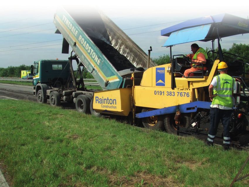
Later Improvements
Construction of the long-awaited bypass around Haydon Bridge was
completed in March 2009. The Highways Agency scheme included 3km
of road together with the construction of four new bridges. In addition
various landscaping and environmental works were also completed so as
mitigate the impact of the bypass on the surrounding countryside. The
new bypass removes 12,000 vehicles per day from the village (of which
approx. 2,000 are HGV’s) and provides a significant improvement for
A69 road users and Haydon Bridge residents.

The Haydon Bridge Bypass was funded by the Highways Agency as a
new addition to the A69 route. The new road now becomes the
maintenance responsibility of Road Link but the existing road through
the village was transferred to Northumberland Council.

An area of land at Haltwhistle was identified by the local authority as a
business park with the intention of encouraging economic regeneration
in this area. Direct access to the land on each side of the A69 was to be
taken from the Haltwhistle Bypass. The Highways Agency gave approval
for access off the A69 and the scheme was completed with developer
funding in early 2009.

                                                                            8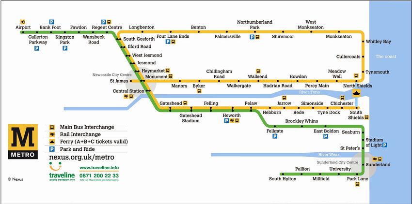
Conclusions
DBFO Contracts have accelerated the introduction of cost efficiencies,
innovative techniques and whole-life cost analysis into the design,
construction and maintenance of road schemes.

It is argued that DBFO Contracts using the shadow toll payment
mechanism have delivered real value-for-money savings for the
Highways Agency when compared to traditional methods of procuring
road construction and maintenance.

The toll banding structure means the Highways Agency expenditure is
capped and they have obtained an accurate picture of their financial
liability for 30 years for the A69.

Safety Performance and Lane Closure Charges encourage Road Link to
consider safety as well as minimising delays at roadworks and by
improving both there are measurable benefits not only for Road Link and
the Highways Agency but for all A69 road users.

Road Link (A69) Ltd are confident that since 1996 they have ensured
that the A69 is a well-maintained, safe and reliable all-weather trunk road
link across the north-Pennines and that this will continue until 2026.

Thanks to Trevor Walker of Road Link (A69) Ltd, for preparing this article

If you enjoyed this article, try also:

Sixty Years of Highway Maintenance

The A1 Trunk Road

The A19 Trunk Road

Memories – surface dressing

Memories – winter services
                                                                              9
THE CHARTERED
INSTITUTION OF HIGHWAYS
& TRANSPORTATION
Running the Tyne
and Wear Metro
The Tyne and Wear Metro is a light rail system
with 78km of track and 60 stations, many of them
interchanges with bus and other rail services to
provide integrated public transport. It was
conceived in 1971, opened in 1980, completed in
1984 and extended in 1991 and 2002.
While faithfully serving the travelling public for over 30 years, political
upheaval, market deregulation and cost pressures have ensured the
way Metro is run and managed has continuously evolved. But with a
major modernisation programme now under way, its future looks bright.
1The Original Metro
The Tyne and Wear Metro is a light railway rapid transit system,
initially built with 55km of track and 44 stations to serve parts of North
Tyneside, Newcastle, Gateshead and South Tyneside. Detailed planning
was started in 1971, as a core element of a planned integrated passenger
transport system, with construction commencing in 1974. The original
system was fully open by 1984. Two extensions to Newcastle Airport
and to Sunderland were added to the system by 2002.
Operating the System
Metro was originally conceived in 1971 by the former Tyne and Wear
Passenger Transport Authority, a regional body to promote and manage
public transport on behalf of local authorities in the area. In 1974 Tyne
and Wear Metropolitan County Council (T&WMCC) came into being
and set up the Passenger Transport Executive (PTE) to continue the
management of public transport and administer funds on behalf of the
council. In 1996 the PTE took on the trading name Nexus.
23
Nexus owns Metro, and the Shields Ferry. It funds those bus services
requiring public subsidy, and also main line rail services between
Sunderland and Newcastle. There were difficulties during construction
of the Metro in 1976/77 between the PTE, (then) British Rail whose
lines were being converted, and the rail unions as to who should own
and operate Metro. The PTE eventually prevailed.

T&WMCC was abolished in 1986 and since then Nexus has owned and
managed Metro on behalf of the Tyne and Wear Integrated Transport
Authority (ITA), which brings together councillors from the five
unitary authorities of North Tyneside, Newcastle, Gateshead, South
Tyneside and Sunderland in a single strategic body. In 1996, British
Rail was privatised but again Nexus held on to ownership of Metro.

Further changes took place in 2010 when DB Regio Tyne and Wear
Limited (a subsidiary of the German transport corporation) was
appointed to operate Metro to a specification set by Nexus. However,
Nexus continue to own, manage and modernise the system, with the
ITA having overall responsibility for fares policy and Nexus taking all
fare revenue.

The ITA receives money for all of its services from a levy on the five
district authorities, in proportion to their population. They also apply
for and receive grants from central Government and other sources. The
revenue from fares and advertising keeps the subsidy per journey lower
than comparable UK systems but fares in themselves do not meet the
full cost of operating Metro, even with the highest patronage per
kilometre of any light rail system outside London.

In recent years Metro has covered just below 70% of its operating and
maintenance cost from fares revenue with the remainder coming from
national and local Government subsidy. In 2011, the income to Metro
was £41.5m while the operating cost was £60.5m.

                                                                           4
Users of the Metro would observe that it is a well used frequent service,
with trains often packed at peak times and still well occupied in
evenings and weekends. The timetable has changed over the years to
respond to demand. It has settled down to a 12 minute frequency for all
parts of the system, with extra trains at peak times. The ‘green’ and
‘yellow’ routes overlap between South Gosforth and Pelaw to provide a
train every six minutes and additional peak services increase the
frequency to a train every three minutes through this ‘central area’. The
great benefit of this is that during busier times of day, passengers don’t
need to look at a timetable for the majority of journeys but just turn up
for the next available train. There are real time indicators on all
platforms to inform passengers.
The fact that the standard two-car trains, with a crush-load capacity of
600, always stop and allow people to board and disembark quickly
gives the service a considerable level of reliability. Passenger numbers
rose to a 20-year high in 2009 of 41 million journeys, though there has
been a recent falling back in the current economic climate to 37.5
million.
Further Improvements
In the decade that followed the Sunderland line’s opening, new stations
and amenities were added to the existing Metro network, which now
totals 78km. The opening of Northumberland Park Station in 2005 was
an example of how high quality public transport can enhance economic
development.
The £5.7m station in North Tyneside is at the heart of a large new
housing and retail project by private developer Northumberland
Estates. The station was funded by the developer and quickly became
the busiest in the area, used by 640,000 passengers a year.
5There were 1,500 homes within 800 metres walking distance when the
station opened on what was a mixed brown and greenfield site on the
urban fringe. Further housing continues to be provided in 2012 close to
the station. Northumberland Park is also five minutes by dedicated bus
to Cobalt, one of the largest new office parks in the UK.
Northumberland Park was Metro’s 59th station and in 2008 the 60th
opened at Simonside. The latter £3.2 million project was funded by
Nexus from land sales and a grant from the European Regional
Development Fund. The station is a wayside halt in a deprived
community in South Tyneside with low levels of employment and car
ownership. It creates a quicker and more frequent public transport link
to employment and training opportunities in South Shields, Gateshead
and Newcastle.
6By 2006 the focus was on making the case to Government for funds for
two strategic programmes. These were to secure the system’s long-term
future as assets and infrastructure approached the end of its planned life
of 30 years, and to modernise ticket sales. Meanwhile continual
improvements were made to amenities at key locations.
Pelaw station, the main change point for passengers between lines from
South Shields and Sunderland, was upgraded in 2007 with an internal
glass waiting area installed on the island platform plus covered entrance
routes. The car park at Hebburn was tripled in size in 2009 in a
developer-funded project.
7Between 2008 and 2010, the deep underground station at Haymarket
used by six million passengers a year was completely rebuilt. The
project was funded through the lease of air rights above the station, at
the north end of Newcastle’s main Northumberland Street shopping
area, to trigger a £20m mixed use retail and office development, named
Haymarket Hub.
Nexus raised £6 million investment from this, which provided a new
street-level concourse with increased retail, a third escalator, and
remodelled interiors throughout, creating a brighter and more spacious
feel. Haymarket showcased a new evolution for Metro station design
from architects Sadler Brown, the first major change since the opening
of the Sunderland line in 2002 and the original architectural templates
of the Faulkner Brown practice, set down in the 1970s.
Vitreous enamel panelling was retained but with individual panels
manufactured to a much smaller ‘letterbox’ shape, allowing the creation
of curved surfaces in place of the square appearance of older stations.
Off-white was replaced by a cleaner true white internally contrasting with
black for signage and exteriors. Elements of the original Metro identity –
the use of the bespoke Calvert font in signage, the ‘supergraphic’ giant
station name on platform walls, and the iconic ‘yellow M’ logo – were
retained and enhanced to provide strong brand continuity.
8Haymarket proved a design success and blueprint for the refurbishment
of further stations. It also featured a new art commission, Canon, by
Lothar Goetz, with colour interventions at points of passenger amenity,
such as exits and information points.
Sunderland station also benefitted from an innovative funding
mechanism and the input of artists in the refurbishment of platforms,
completed in 2010. Three artists contributed to the challenging project
to improve the low-ceilinged 150-metre island platform, the most
notable being Jason Bruges Studio, which created an animated light
wall populated by the shadowy moving figures of ‘ghost’ passengers.
The Sunderland Metro station is shared with national rail services, but
£7m capital funding was obtained through the Department for
Transport via the principle of hypothecation of service decrement costs.
The sum represents the prospective revenue to be saved over 18 future
years by reducing the frequency of regional ‘heavy rail’ trains between
Sunderland and Newcastle from two to one an hour and replacing them
with the cheaper Metro service.
Metro: All Change
The bid to modernise Metro was based on research that showed that
every £1 invested in the system generated £8 in the regional economy.
Compared to the consequences of letting the system decline and fail,
the successful outcome ensured the next decade will see fundamental
change.
The £25 million Government-funded Ticketing and Gating project will
see Metro’s original Creuzet machines replaced in 2012 by new models
accepting note and card payment for the first time. The machines are
smart-enabled and linked to the return of gate lines at 13 station and
validators at all 60 in preparation for the roll-out of the Pop card brand.
9Smart ticketing on Metro is the foundation for the wider introduction of
the technology across the north east, both for public transport and other
public services, education and commercial applications, through NESTI
(North East Smart Ticketing Initiative – a collaboration of 12 local
authorities and the Tyne and Wear Integrated Transport Authority).
The delivery of the ‘Metro: all change’ modernisation programme
dwarfs this in capital terms, with a £350m funding commitment from
2010 to 2021 for the wholesale renewal of Metro infrastructure (with the
exception of the ‘new’ Sunderland line), stations and trains. This,
combined with local contributions takes planned investment to £385m,
representing the largest transport project in the region’s history.
10Work is already well underway in phases moving around the Metro
system. Much is ‘behind the scenes’ through the replacement of track and
technology in a continuing series of weekend and sometimes longer line
closures.
The project is delivering the refurbishment of the original 90 Metrocars,
the first of which entered service in early 2012, along with refurbished
stations, such as Chillingham Road, Meadow Well and Howdon which
are already complete.
More information on the Metro and other Nexus services can be found on
the website www.nexus.org.uk.
Thanks to Huw Lewis of Nexus for preparing this article.
If you enjoyed this article, try also:
‘Building the Tyne and Wear Metro’
‘Innovation and Infrastructure in the Bus Industry’
‘Railways in the North East’
11THE CHARTERED
INSTITUTION OF HIGHWAYS
& TRANSPORTATION
Sixty Years of
Highways Maintenance
Many aspects of highway maintenance have been
transformed over the last sixty years. This has
been driven by the development of computerised
highway asset management systems, the
development of analytical methods of assessing
road surface condition, the development of new
materials, changes in public sector procurement
to bring in the private sector and improved
integration with other transport policy areas.
Highway maintenance has embraced these changes but the decisions
made by the highway engineer are still at its heart and perhaps this has
not changed at all. Roads remain one of the most important physical
assets for which public authorities are responsible. Effective
maintenance and management is crucially important to both users and
the community at large and its safe and efficient operation provides vital
support to the national and local economies.
1What is Highways Maintenance?
The term highway maintenance covers a wide range of different general
activities which can be grouped together as follows:
• Reactive Maintenance includes responding to inspections, complaints
or emergencies eg filling potholes, clearing and making safe damage
resulting from traffic accidents
• Routine Maintenance includes surface patching work, cyclic
activities such as grass cutting, weed spraying, gulley cleaning, road
sweeping and maintenance of planted areas and trees within the
highway
• Programmed Maintenance is normally carried out to a planned
schedule and includes surface dressing, resurfacing, strengthening
or reconstruction of roads or footways. It also includes kerbing and
road drainage improvement
• Winter Services which seek to keep the network functioning safely by
salting and clearance of ice and snow
• Emergency Response to weather and other emergencies affecting
the highway network
• Regulating and Inspecting the activities of others within the road
network
2What are the Changes?
The last twenty five years in particular has seen many changes in how
highway maintenance is carried out. They are largely as a result of the
development of sophisticated road condition assessment and
information management systems, new developments in road surfacing
materials, new ways in which highway maintenance is procured,
improved integration with other aspects of transportation and
improvements in winter maintenance techniques.
Road Condition Assessment and Information Management
Systems
An essential part of deciding where and when road maintenance can
best be undertaken is a reliable way of assessing the condition and
strength of the road surface. Only by doing this can the highway
engineer determine road maintenance programmes which make most
effective use of the restricted resources available, choose the right
maintenance technique and reliably prioritise the different locations
requiring treatment.
In 1952 the assessment of road condition, the determination of priorities
and maintenance solutions was largely subjective drawing heavily on
the individual highway engineer’s experience.
However since the late 1970s there has been continuing development of
computerised analytical methods of measuring road condition and
determining priorities and treatments. One of the aims was to provide
improved road surface condition data across the road network on which
the highway engineer could base his decisions.
3An early such method was CHART (Computerised Highway
Assessment of Ratings and Treatments). This used a visual survey
carried out by surveyors walking along the road measuring visual
defects and recording them in a standardised way. It became a
requirement for the trunk road network and it was adopted by most
highway authorities for the A class roads.
The Deflectograph survey was developed for measuring the strength
the structure of the road surface and, based on this, a methodology for
estimating how many years the road would last until failure occurred.
This type of survey was carried out by a large (and expensive) survey
vehicle travelling at walking pace along the road. Its use became a
requirement on the trunk road network in the early 1980s but due to
their high cost, there were only a very small number of vehicles in
operation in the country. One however was operated by the Highways
Laboratory at Durham County Council.
The above survey techniques provided valuable information on which
the highway maintenance engineer could base his judgements.
However they were slow to carry out and usually required lane closures
or stop/go traffic control to protect survey operatives. As traffic
volumes grew, this caused increasing delays to traffic.
4Consequently there were pressures to develop automated machine
surveys which could assess the road surface condition at normal traffic
speeds. After much development work, this type of survey first became
available around 2000 and was known as SCANNER (Surface
Condition Assessment of the National NEtwork of Roads).
Another vehicle based survey SCRIM (Sideway-force Coefficient
Investigation Machine) is carried out at near normal traffic speeds and
this measures the wet skid resistance of the road surface. This helps to
lower accident rates by identifying locations where there is a risk of
skidding on wet roads. Ground penetrating radar is also now available
to show the thickness of construction layers of road along whole
sections, which can supplement the taking of cores samples.
Over the last twenty five years the development of information
management systems has transformed the way in which highway
maintenance is managed. They have enabled large quantities of data on
road condition to be stored, together with data on what is in and on the
whole road network (e.g. numbers and location of road signs, number
of gullies). The combination of detailed inventory information and
pavement condition data has enabled comprehensive asset management
systems to be developed. Ready access to and analysis of this data has
greatly enhanced the planning of maintenance work and helped in
demonstrating the level of funding needed to keep the road network in
an acceptable condition.
Utility companies have the statutory right to install and maintain their
apparatus in the highway and this needs careful management by every
highway authority as it has maintenance implications. Comprehensive
management systems have been developed to ensure that these works
are undertaken safely and traffic disruption is minimised. Trenching
and reinstatement of the highway also results in surface, structural and
environmental damage which affects pavement condition by reducing
5the life of the carriageways and footways and creating increasingly
patchy surfaces.
Developments in Road Surfacing Materials
The choice of what materials to use in the road surface is largely
influenced by the type of road, the volume and speed of traffic and the
particular site location. This choice will determine how the road surface
stands up to the loading and constant wear and tear imposed on it by the
traffic.
Traffic growth over the last sixty years and increases in the size of
heavy goods vehicles have placed the road surface and underlying
construction layers under increasing stress. To meet this, the road
surfacing industry has carried out extensive research and development
and now many new proprietary products are available. Generally these
newer options have binders which have been modified by the addition
of polymers to give enhanced performance properties.
6Traditional road surfacing materials (hot rolled asphalt and bitumen
macadam) have been supplemented by a whole range of new options.
These include stone mastic asphalts / thin surfacings and slurry / micro
surfacings, give the highway engineer a wider range of surfacing
materials to choose the most cost effective maintenance solution. A
Glossary of road surfacing types is given at the end of this article.
Traditional surface dressing techniques, which have been around for
over 100 years, have also seen development. Improvements such as
polymer modified binders and the introduction of techniques such as
“racked in” dressings, using two sizes of stone, have provided more
stable surfaces and reduced chipping damage.
Even the basic action of filling in potholes has not been immune from
change. Previously potholes were filled manually with bituminous
material and usually compacted by hand. Now a mechanised technique
(Jetpatcher) is available in which the material is forced into the pothole
by compressed air, with consequent better durability and operational
time savings.
The recycling of aggregate from existing roads is now becoming a more
common occurrence. This not only conserves a valuable raw material
but it also can be cost effective. Recycling technologies are advancing
rapidly. Increasingly the surfacing industry is developing ways of
reducing the carbon footprint of road construction and maintenance
both in the production of materials, transport and laying techniques.
7Changes in Procurement
In the first half of the last sixty years, carrying out highway
maintenance was the preserve of the local highway authority’s own
Direct Labour Organisation (DLO), with input from specialist
contractors (e.g. surfacing and surface dressing contractors) as required
from time to time for specific schemes or programmes of work.
However some local authorities with extensive road networks to look
after such as County Councils did find it cost effective to operate their
own surfacing and surface dressing gangs as well.
The introduction of Compulsory Competitive Tendering (CCT) for
local authority “blue collar” services in the late 1980s radically changed
the way in which highway maintenance was delivered. As a result of
CCT, for the first time, private contractors were brought into the
delivery of the highway maintenance service as a whole, rather than just
for specialist services. However in some local authorities the DLO was
successful in retaining the highway maintenance work in-house.
The requirement for CCT was removed by central government in the
late 1990s. However it has left a legacy of a more commercial approach
applied to service delivery and the involvement of the private sector in
8local authority highway maintenance work through partnership
arrangements with the local authority or through out-sourcing.
The maintenance of Trunk Roads, such as the A1 and A19 is the
responsibility of central government and until the early 1990s they
carried this out through agency agreements with the County Councils.
In a move parallel to CCT on local roads, central government changed
to a regime of competitive tendering involving private sector
consultants for management services and contractors for works
services. Initially these two aspects were separate contracts, but in later
rounds of tendering they were combined.
In 1992 central government introduced the concept of Public Private
Partnerships (PPP) as a means of attracting private capital and expertise
into the delivery of public services. As part of this, central government
introduced Design Build Finance Operate (DBFO) arrangements on the
A69 and A19 (south of the River Tyne) Trunk Roads. Both included
aspects of new build – for the A69 the Haltwhistle Bypass, and the A19,
improvements between Norton and Parkway. The arrangements also
included maintaining the routes, together with long lengths of adjoining
road network, for a thirty year period up to 2027.
Private Finance Initiative (PFI) is another variant of PPP, where a whole
service is managed by a private company at an agreed cost over a
specified number of years. A handful of local authorities in some parts
of the country have introduced a PFI for the whole of their highway
maintenance service, but, in this region, the approach has only been
taken up for street lighting as a joint venture in North Tyneside /
Newcastle and in Sunderland.
9Integration with Transport & Strategic Policies
Over much of the last sixty years the planning and delivery of highway
maintenance has often tended to have been poorly integrated with other
highway works and wider policy areas. At best, this did not provide
opportunities for adding value between services and, at worst, led to
unresolved conflicts between policies, programmes and priorities of
different services.
However the Comprehensive Performance Assessment regime
introduced after 2000 for local authorities has created a stimulus for
policy integration between services. This is now apparent with local
authorities’ capital funding for highway maintenance provided through
the Local Transport Plan (LTP). This encourages the promotion of
highway maintenance in the wider context of all public spending on the
road network and other transport facilities.
It is now recognised through the LTP that the development of a
comprehensive Highway Asset Management Plan (HAMP) is
fundamental to demonstrating the value of adequately funded and well
planned highway maintenance in delivering the wider objectives of
corporate strategy, transport policy and value for money.
Winter Maintenance
Winter maintenance plant has evolved over the last sixty years with the
continued development of powerful dedicated specialist vehicles for
gritting and snow clearing, together with improved systems for
converting general highway maintenance vehicles for use as gritters
and snow ploughs.
10However, perhaps the biggest change in recent times has been the
introduction by most highway authorities of ice prediction systems.
These include roadside sensors at key locations and coupled with
thermal mapping of the road network give the winter services manager
instant access to actual conditions across the road network. This
information is also accessed by the Weather Forecasting organisation
and helps them refine and improve their predictions.
The de-icing agent, rock salt, is an expensive material and there is now
increasing guidance on ensuring, for different conditions, that optimum
rates of spread on the road surface are used. Stock management and
control has improved and the benefits of storage in purpose built salt
barns, rather than open stockpiles, to prevent leaching out is recognised.
In a recent development, the Highways Agency has moved to treating
the trunk road network with pre-wetted salt. In this technique the gritter
carries brine as well as salt and the two are mixed just prior to
spreading. The advantages of this are better retention of the salt on the
road surface and a quicker de-frosting action. However this does reduce
the salt carrying capacity of the gritter.
The trend over the last fifteen years has been for milder winters with
reduced snowfall, but the relatively harsher winters and higher snowfall
in 2009 and 2010 have been a reminder of conditions more common
forty or fifty years ago.
11Thanks to Malcolm Smith, of CIHT North Eastern Branch, for preparing
this article.
If you enjoyed this article, try also:
The A69 Carlisle to Newcastle DBFO
Highway Authorities in the North East
Memories – surface dressing
Memories – winter services
Memories – the ‘Yellow Circus’
12Glossary of Road Surfacing Terms
Bitumen Macadam – a well proportioned mixture of aggregate
particle sizes to give a dense matrix on compaction which is held
together by a low bitumen content binder. Its strength largely is derived
from the interlocking of the aggregate particles. It is laid by a paving
machine and is generally used on roads with lower traffic volumes.
Hot Rolled Asphalt – a traditional material used to surface roads with
higher traffic flow and it consists of two components, the surface course
mixture and high skid resistance stone chippings pre-coated with
bitumen. The surface course mixture is made up of a bitumen binder
mixed with intermediate quality small sized aggregate. Its strength is
derived from the cementing together of the binder/aggregate mix. It is
laid to the required thickness (usually 40mm) using a paving machine.
The pre-coated chippings are now spread on to the laid surface to give
the final compacted surface a texture and a skid resistance.
Recycling – the technology for recycling road aggregates is advancing
rapidly and additional developments include the use of glass and other
recycled waste products in the surfacing course.
Typical methods of recycling road aggregates include:
• Repave which involves the heating the existing road surface to 150
degrees C and scarifying it up to a depth of 30 mm. Re-profiling is
carried out straight away using an oscillating floating screed. The
process is completed by the immediate application of new surfacing
material and compaction. The heat retained by the scarified material
from the existing surface welds it together with the new surfacing
material.
13• Remix is similar to repave but the broken up existing road surface is
removed, crushed, graded, reheated and mixed with some new
material and binder before being re-laid and compacted at the
original site.
• Hot recycling is similar to the remix process, except that the existing
road surface material is removed by planing. It is then removed
off-site, crushed, graded and heated, the material is mixed with
binder and re-laid and compacted. This process can also be done on
a smaller scale on-site by using portable machinery.
Slurry / Micro Surfacing – cold laid, very thin proprietary surfaces
incorporating a bituminous emulsion binder with fine graded aggregate
and filler. The application is either by machine or hand and typical the
laid thickness is less than 15mm. A single application giving a thickness
of about 6mm is usually referred as a slurry. Micro surfacing
incorporates a polymer modified binder and is often a two coat
application up to a thickness of 15mm. They have similar properties to
surface dressing in sealing the road surface and restoring skid
resistance, but additionally, particularly the thicker applications can
reshape and re-profile the existing road surface.
Stone Mastic Asphalt – a proprietary surfacing used for the running
surface of the road. It is made up of a high content of coarse aggregate
particles which interlock to form a stone skeleton. This is filled by a
high bitumen content binder and a filler. It has been developed to give
improved resistance to deformation which stems from more aggregate
to aggregate contact than other types of surfacing.
14Surface Dressing – is a long established cost effective method
prolonging the life of the road surface by sealing it to prevent water
penetration and arresting disintegration of the existing surface, as well
as restoring skid resistance. The process is relatively fast and consists of
spraying a bituminous adhesive coat on the existing road surface,
followed by spreading a layer of high quality aggregate chippings. The
bituminous adhesive coat can be modified by the addition of polymers
to enhance performance. At higher stress sites the technique of
‘Racking in’ is used. This is the successive laying of one layer of binder
followed by two layers of chippings, the second layer being of a smaller
size.
Thin Surfacings – are a grouping of modern proprietary surfacings
which have been developed to give safer, durable and quieter road
surfaces. They include stone mastic asphalt. Depending on
circumstances and the particular proprietary surfacing they can be laid
at thicknesses down to 18mm.
15THE CHARTERED
INSTITUTION OF HIGHWAYS
& TRANSPORTATION
The Port of Blyth
The Port of Blyth is located at the mouth of the
River Blyth in Northumberland. It was a key port
for the coal trade, which reached its peak in the
early 1960s, but within another ten years, was
declining quickly.
Like many others, it could simply have ceased trading and become a
derelict of the industrial past. But the port reinvented itself, attracting
other cargo, improving, modernising its facilities and diversifying to
continued success. Now it looks to be at the forefront of the
renewables industry, using its strategic location to service the
development of offshore wind power generation in the North Sea.
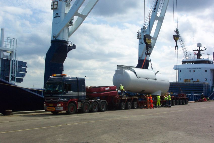
1The Port of Blyth and its facilities lie on both banks of the River Blyth estuary, seven miles north of Tynemouth, on the Northumberland coast. It is a tidal deep water port, accessible in nearly all weather conditions and provides modern cargo handling facilities. History While recorded use of the site as a port dates back to the 12th century, it was not until 1788 that the first elevated staithe was constructed, along with the ‘High Light’ lighthouse which remained in service until in 1984 when it gave way to more modern navigation aids. The Blyth Harbour and Docks Board was formed in 1853 and with the Harbour Act of 1858, dredging began at the harbour to allow larger access for ships. In 1882 an independent Statutory Trust was formed to manage the port, an arrangement that continues to this day. Because of this, all surpluses are reinvested to improve facilities at the port for the benefit of stakeholders and the region. Historically, the port’s trade was dominated by coal exports from the numerous local mines. This was enhanced with a railway link to a staith south of the river 1849. Coal shipments increased rapidly to 200,000 tonnes per year, reaching 5.5 million tonnes per year in the 1930s and making it the largest coal exporting port in Europe. It peaked at 7.0 million tonnes in 1969. 2
Shipbuilding also had an important rolw to play in the port, and this
element gre throughout the 19th and early 20th Century, particularly
during the two World Wars.

By the late 1960s the coal trade was declining. Local mines closed
one-by-one and the port suffered accordingly. The same was true for the
shipbuilding industry, with the last yard closing at the port in 1966.

Reinvention
By the early 1970s the port’s future looked extremely bleak. However a
reversal of fortune came when a major aluminium smelter was
established five miles north at Lynemouth. With it came an import
terminal, built at the port to handle the large volumes of raw materials.

The 1970s also saw expansion of the paper import trade from Finland,
and by 1998, Port of Blyth was a major paper import terminal, handling
0.5 million tonnes that year.

                                                                            3
Commercially, the import trade was aggressive, and the loss of paper
import contracts in 2000 was a major blow to the port. Once again
though, reinvention was the key to survival, and the port diversified into
container handling, plywood, project cargo for offshore and renewal
energy sectors, bulk commodities such as cement, stone, grain, fertiliser
and animal feed and, perhaps ironically, coal imports. A new bulk
terminal at Battleship Wharf was built in 2006, including a rail link, to
handle the throughput of goods.
In recent years the port has invested heavily in the renewable energy
sector with several major projects. The first came in 1992 when Blyth
Harbour Wind Farm was constructed on the East Pier. It was followed
in 2000 by the first pilot offshore wind farm in the UK, about a
kilometre out to sea.
In 2002, the New and Renewable Energy Centre was established at the
port to develop and test new energy technologies and equipment. This
became the National Renewable Energy Centre (NAREC) which has
invested over £160m in new test facilities and an offshore demonstrator
site, due to commence operations this year (2012).
4The Port Today
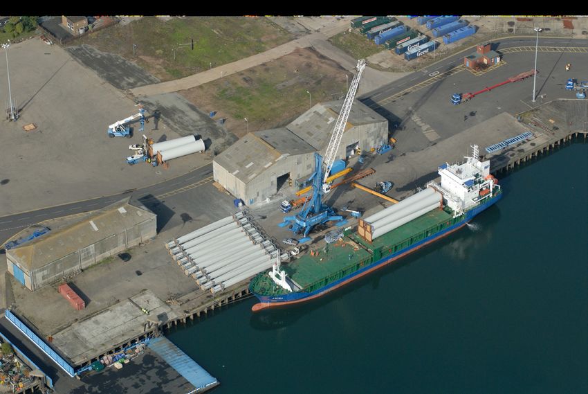
The harbour facilities offered by the Port today consist of five sites, on
both sides of the river estuary, as shown on the plan. Each site offers
different facilities, with three also having rail links.
South Harbour provides two deep water berths, a Roll-on/Roll-off
(RoRo) pontoon and over 35,000m2 of warehousing. It is a “clean
terminal” for paper products, containers, plywood and pulp, as well as
project cargo including wind turbines.
Wimbourne Quay has a single berth with a RoRo pontoon, limited
Lift-on/Lift-off (LoLo) options and 27,000m2 of warehousing. It
handles log exports and general warehousing.
Bates Bulk Terminal is a large site of 9.5 hectares with a rail link, open
storage and loading conveyors. It is a potential site for port expansion
or redevelopment.
Battleship Wharf was redeveloped in 2006 at a cost of £10m to
provide a 15 hectare bulk terminal with an extended 4 berths quay up to
9m draft, 10,500m2 of bulk warehousing, open storage and a rail link. It
handles all bulk cargo (coal, aggregate, agribulks, bagged cargo etc).
5Alcan Bulk Terminal is a deep water (10.4m) import terminal which
handled 0.5 million tonnes per year of Alcan raw materials, until the
aluminium smelter closed in 2012. It has a rail link and storage silos.
Today the Port handles about 1.5 million tonnes of cargo each year.
The Future
In early 2012 it was announced the Alcan aluminium smelter was to
close, a fresh blow to the local economy, and the port which had
handled the bulk import of raw materials for the smelter.
Nevertheless, as before, the port continues to diversify, by maximising
its other cargo handling trade, and promoting its strategic location in
relation to offshore wind power generation in the North Sea.
In a partnership arrangement with Northumberland County Council, the
port has established the Blyth Estuary Renewable Energy Zone. The
initiative offers development opportunity sites both in and adjacent to
the port, to attract manufacturing and provide harbour facilities for the
developing offshore renewable energy industry in the North Sea.
The port is also looking to provide facilities to handle biomass material
for a proposed new power station on the site previously used to generate
power for the Alcan smelter. If constructed, it would burn around 0.5m
tonnes of biomass per year.
6More information on the Port of Blyth can be found at www.portofblyth.co.uk.
Thanks to Malcolm Smith of CIHT North Eastern Branch, for preparing
this article.
Additional thanks to Alan Dodd, Port Director, for useful comments and
supply of photographs.
7THE CHARTERED
INSTITUTION OF HIGHWAYS
& TRANSPORTATION
Highway Authorities
Over Sixty Years
For the last 60 years, the responsibility for the
region’s non-trunk road network has rested with
local authorities. The independent county
boroughs, in place in 1952, gave way to the large
metropolitan councils of the 1970s and, with a
number of intermediate steps, to the unitary
authorities, in place in 2012.
Consequently, the number of authorities involved with managing the
9,800 miles of local roads in the North Easy has reduced considerably,
from 53 to 12. We chart the course of reorganisation which takes the
highway authorities to where they are today.
1The CIHT North Eastern Branch covers the counties of
Northumberland, Durham, Tyne & Wear and Teesside – a region
accommodating nearly 10,000 miles of roads to meet the travelling
needs of the community, businesses and industry. The public bodies
responsible for improving, maintaining and managing this network are
called highway authorities.
Approximately 9,800 miles (98%) of the road network is ‘non-trunk’
and therefore falls under the jurisdiction of the highway authority,
whose duties, within their own boundaries, are discharged by the
particular local authority. The remaining 200 miles (2%) of motorway
and trunk roads are the responsibility of the Highways Agency.
The only constant in local government from 1952 to 2012 has been
change and this has affected how the region’s road network is
maintained and improved. Of particular importance was the Local
Government Act 1972, which instigated perhaps the biggest upheaval
in 1974, though further changes have since taken place.
This article takes a look at some milestones in local government history
and the impacts felt on the region’s highway authorities.
21952 to 1974
Local government during this period was based on a two tier system,
with county councils above a patchwork lower tier of urban and district
councils, and non-county boroughs. The lower tier authorities were
relatively small, with limited powers of self government, often shared
with the county councils. The more populated areas of Tyneside,
Wearside and Teesside however, were designated as county boroughs,
and were independent, self governing authorities.
Generally the rural districts covered larger areas of sparsely populated
countryside, whereas the urban districts and non-county boroughs were
small in area, more densely developed and with larger populations. This
was also the case for the county boroughs.
3
32
8
3Responsibility for the region’s road network was split between the
different types of authorities as shown in the following table, which also
shows the numbers of each type in the region during this period. Local
Authorities 1952 to 1974 presents this in full following this article.
Nationally, throughout the 1950s and 1960s there was growing
realisation that local government, in its present form, could not cope with
the rapidly changing economic landscape. In the North East, some
changes were already being made, the most notable being the creation of
Teesside Borough Council in 1968. This brought together the previous
authorities covering Middlesbrough, Stockton, Redcar, Thornaby,
Billingham and Eston, along with parts of other urban and rural district
councils south of the River Tees. This brought the whole road network on
both sides of the Tees estuary into the jurisdiction of one council.
A more comprehensive national reform was on the cards however, and
with the Local Government Act 1972, came the largest upheaval in local
government history.
The Reorganisation of 1974
On 1st April 1974 the Local Government Act, 1972 came into force. All
existing local government structure in England Wales (outside Greater
London) was abolished and replaced with a two tier system. It created 45
new counties – six metropolitan, the remainder non-metropolitan.
The six new metropolitan councils were based on the Greater London
‘model’ and created to address specific issues of administering large
conurbations. Of the remaining non-metropolitan councils, three new
counties were created with the aim of uniting areas based on river
estuaries (Avon, Cumbria and Humberside), whereas the rest were based
on previous historic county boundaries, but with some significant
changes and mergers.
4Under the second tier of reorganisation, the 45 new counties were further
subdivided into smaller administrative areas, forming metropolitan
boroughs, and districts within the non-metropolitan counties. The
implications for North East local government were the new counties of
Northumberland and Durham, created similar to the previous ones, but
with some reductions in size and boundary changes to accommodate the
Tyne and Wear Metropolitan County Council and the non-metropolitan
county of Cleveland.
The new second tier district councils in Northumberland and Durham
were quite different to the previous urban and rural district councils, prior
to 1974. As they covered larger areas, there were fewer of them. In Tyne
and Wear, five new metropolitan boroughs were formed, some of which
retained familiar names – Newcastle, Gateshead, Sunderland – but with
increased geographic areas, taking in some of the adjacent rural area and
smaller settlements. The figure shows the two-tier system of Tyne and
Wear Metropolitan County Council.
Local Authorities 1952 to 1974
5In the south of the region, Cleveland County Council was based on the
previous short lived Teesside Borough Council with the addition of
Hartlepool and an extension down the coast to south of the Tees.
The new county councils became responsible for the non-trunk road
network but, in practice, entered into agency agreements with the
majority of the lower tier authorities for delivery of some highway
services. These agreements varied considerably, and were often limited
to a district’s rural areas with the county remaining in control of the
principal and urban roads within its boundary. This approach,
unfortunately, tended to perpetuate the previous lack of clarity
experienced by the public over which authority was responsible for
roads in their locality. However the reverse was true in Tyne and Wear,
and Cleveland, where just one authority assumed full control of the
road network, from strategic policy through to routine maintenance.
Local Authorities 1974, following this article, shows the highway
responsibilities at the time.
1986 to 2012
The uniform two-tier structure lasted only twelve years until 1986,
when the metropolitan county of Tyne and Wear was abolished, it might
be argued, for political rather than practical reasons. The lower tier
authorities of Gateshead, Newcastle, North Tyneside, South Tyneside
and Sunderland were retained, becoming unitary authorities
responsible for all services within their boundaries. In effect, they
reverted to the county boroughs of pre-1974 days, once again becoming
separate highway authorities, albeit with a larger geographic area. The
need for a joined up highways and transport strategy across Tyne and
Wear was not overlooked however, and joint working arrangements and
collaborative partnerships developed between the authorities.
6Cleveland County Council was also eventually abolished in 1996 with
Middlesbrough, Stockton, Hartlepool and Langbaurgh (renamed
Redcar and Cleveland) becoming unitary authorities fully responsible
for the road network in their areas. A year later, Darlington became a
unitary authority, breaking free from Durham County Council and
becoming entirely responsible for its road network. Again this was a
reversion to its pre 1974 state, albeit with a larger geographical area.
The Northumberland and Durham two-tier system continued until 2009
when the district authorities were abolished, leaving the two county
councils as unitary authorities, and highway authorities, of their
particular road networks.
As of 2012 the position across the region is one of a number of unitary
authorities of varying geographic size and extent of road network for
which they are responsible. It has been possible, in this situation, to take
advantages of economies of scale to deliver more cost-effective
highway services, along with eliminating ambiguity in the supply
chain, and to the public, over who is responsible for the road network.
Thanks to Malcolm Smith of the CIHT North Eastern branch, for
preparing this article.
If you enjoyed this article, try also:
Motorway and Trunk Road Development in the North East
7You can also read