Key EU space programmes - By Susie Wright POSTbrief 37, June 2020 Introduction Galileo Copernicus EU Space Surveillance and Tracking (EUSST) - UK ...
←
→
Page content transcription
If your browser does not render page correctly, please read the page content below

post. parliament.uk | 020 7219 2840 | POST@parliament.uk | @POST_UK

                  Key EU space
                  programmes

                  By Susie Wright

                  POSTbrief 37, June 2020
                  Introduction                                         4
                  Galileo                                              6
                  Copernicus                                          15
                  EU Space Surveillance and
                  Tracking (EUSST)                                    23
2 Key EU space programmes post.parliament.uk

Suggested Citation
POST (Parliamentary Office of Science and Technology). 2020. POSTbrief 37,
Key EU space programmes. UK Parliament

POST is an office of both Houses of Parliament, charged with providing independent and
balanced analysis of policy issues that have a basis in science and technology. POSTbriefs
are responsive policy briefings from the Parliamentary Office of Science and Technology.
This POSTbrief is based on a literature review, interviews with external stakeholders and
peer review. For further information on this subject, please contact the co-author, Dr Susie
Wright. Layout and design Lef Apostolakis. Parliamentary Copyright 2020. Cover image by
JAXA/ESA
4    Key EU space programmes                                  post.parliament.uk

INTRODUCTION

The EU operates space programmes that provide services to European
citizens and support European infrastructure. The outputs from these
programmes enable Europeans to navigate during their travels,
communicate with each other and monitor the Earth and its climate.1 The
UK space sector has made considerable contributions to the development
and delivery of the EU’s space programmes over the past few decades.2
This POSTbrief discusses three of the key EU space programmes that have
involved the UK:

Galileo
The EU’s global navigation satellite system (GNSS).3 This is similar in principle
to the USA’s global positioning system (GPS) and, once fully operational, will
allow users on Earth to navigate and accurately measure their local time
and position. Many Earth-based industries are reliant on GNSS information,
from emergency services trying to minimise response time to banks time
stamping financial transactions.4,5 Galileo is part of the European GNSS
programme, which also supports the European Geostationary Navigation
Overlay System (EGNOS). EGNOS is a satellite based augmentation system
(SBAS) which increases the accuracy of GNSS systems (such as GPS and
Galileo) over Europe.6

Copernicus
The EU’s Earth observation programme7 consisting of numerous satellites
and ground based sensors that track and measure different features of
Earth’s atmosphere, land and oceans (see POSTnote 566). These data can be
used for a range of applications, including monitoring the impacts of climate
change and coordinating the response to floods and forest fires.8

EU Space Surveillance and Tracking (EUSST)
The space surveillance and tracking system9 monitors space debris in
orbit around the Earth. Space debris is man-made material left over from
previous space missions and satellites (see POSTnote 355). EUSST monitors
the risk of collision between active satellites and debris, as well as hazards
posed by debris re-entering the Earth’s atmosphere.10
5    Key EU space programmes                              post.parliament.uk

These European programmes have provided UK-based companies and
researchers with data, work contracts and funding. This has contributed
to the UK space sector’s annual growth rate of 3.3% from 2014/15 to a
total income of £14.8bn in 2016/17, accounting for 5.1% of the global space
economy.11 The Government has expressed ambitions to grow the sector to
10% of the global space economy by 2030.12 The applications of satellite
data are increasing in scope and are of increasing interest to UK industry,
including a growing number of SMEs (small and medium sized enterprises).11
The Government has also expressed growing interest in the use of data
from space programmes and, in 2014, established the Space for Smarter
Government Programme (SSGP) to drive the uptake of space derived
products across government departments.13,14

The UK has now left the EU and access to the EU space programmes will
change following the transition period.15 The Government has published
advice on how the three space programmes listed above will be affected
from 1 January 2021.15 Potential impacts on the UK include:15–18
• UK companies and academics may lose access to some funding and the
   ability to bid for contracts offered by the EU.
• UK access to certain data may be restricted, limiting the ability of UK
   industry and academia to develop products based on existing space
   data.
• UK access to facilities and specialist skills could be restricted.
• Introduction of trade tariffs could affect the UK space supply chain.

The impact on the individual programmes will depend on what is negotiated
between the EU and the UK Government during the transition
period.15 The Government has expressed interest in continued
participation in Copernicus and continued access to the
services of EGNOS and EUSST.19 The EU has said it is
open to establishing a relationship that allows
the UK access to, or participation in, some EU
programmes, including space programmes.20
Currently, a number of countries, including
the US and Australia, have data access
agreements with Copernicus,21 and
Norway and Iceland are able to
participate fully in the programme
despite not being EU members.22 It
is unlikely that UK involvement in
Galileo will continue as the EU does
not allow non-member states to
be involved in developing security                         Queensland captured by the
systems for the programme. The  20                         Copernicus Sentinel 2 mission
UK Government has said it will                             Image: contains modified
not pursue access to Galileo as                            Copernicus Sentinel data
it is unwilling to rely on Galileo’s                       (2019), processed by ESA, CC
security systems without being                             BY-SA 3.0 IGO
6     Key EU space programmes                                   post.parliament.uk

involved in their development.23 Instead, the Government is exploring
options to build the UK’s own GNSS system and has provided £92m for initial
feasibility studies.24

The UK will maintain access to parts of these programmes and some
funding for the space sector through its membership of the European Space
Agency (ESA).25 Membership of ESA is not linked with EU membership and
thus the UK will continue to have access to ESA space programmes and
funding regardless of what is negotiated with the EU. However, access to
programmes that are co-funded by ESA and the EU, such as Copernicus,
could become more limited.25 Both Norway and Switzerland are existing
examples of non-EU countries that hold ESA membership.25

The following sections of this POSTbrief provide a technical overview of
each of the three space programmes listed above and the involvement of
the UK in these programmes to date. The future of each of the programmes
is discussed in the context of Brexit as well as in light of the impact of
emerging technologies and requirements.

GALILEO

Galileo is the EU’s global navigation satellite system (GNSS),3 which
provides users with an accurate measure of the time and their geographical
location.26 It consists of a constellation of satellites and is a type of position,
navigation and timing (PNT) system.4 GNSS has been described as ‘the
invisible utility’,4,27 and a reliable and resilient GNSS signal is relied upon
across many sectors, including areas of the critical national infrastructure
(CNI, see Box 1). Many people in the UK use GNSS-derived services
multiple times a day to check the time or navigate from A to B using their
smartphones.28 In 2017, it was estimated that a 5-day disruption to GNSS
would cost the UK £5.2bn.27

The Galileo programme was established by the EU to allow greater control
over their access to GNSS.29 Currently, GPS (managed by the US and
available since 1994) is used globally and other countries cannot influence
decisions governing the availability of the signal. Galileo allows the EU more
autonomy. Another benefit of operating a system in addition to GPS is that
it improves the resilience of the GNSS service as there is a back-up available
if one of the systems fails.4,30,31 System failure could occur for a number of
reasons, including technical issues or a malicious attack.27 In July 2019,
Galileo experienced an outage of 6 days due to technical issues.32 In January
2016, GPS was impacted by a technical problem that caused errors in its
timing measurements.33 Once Galileo is fully operational it is expected that
7    Key EU space programmes                                           post.parliament.uk

individual devices will be able to use signals from a combination of GPS,
Galileo and other services (Box 2).30,34

Since 2016, Galileo has been in its initial operational capability phase but
it is expected to reach full operational capability in 2020.35 Once it is fully
operational there will be an open signal for use by anyone, as well as a more
secure signal for authorised users. There will also be a dedicated search
and rescue service and a higher accuracy signal to complement the open
signal.36

Funding for the Galileo programme is provided by the EU.37 The European
Commission (EC) oversees the management of the programme on behalf of
the EU.38 The EU delegates deployment, research and development aspects
to ESA.38 Rules for contract procurement are decided by EC regulations.39

     Box 1. Use of GNSS within critical national infrastructure
     GNSS is widely used across a number of sectors and underpins aspects of the
     critical national infrastructure (CNI).27 Examples of CNI relying on GNSS include:
     •   Defence. GNSS is used across a range of defence applications including
         search and rescue in combat situations and directing drones.4
     •   Emergency services. The emergency services use GNSS to navigate as
         quickly as possible to an emergency.4 GNSS is also used to manage and
         schedule vehicles to enable faster response times.27 Furthermore, if a
         call to the emergency services is made from a mobile phone, GNSS data
         from the phone may be passed to the call centre to locate the caller more
         accurately.4,27
     •   Energy. Timing information from GNSS is used to find faults on the
         National Grid.27 Different parts of the National Grid must operate on the
         same synchronised time, ensuring supply and demand are matched so
         that power can be distributed reliably.40 Reliable time synchronisation
         across the grid is becoming increasingly important as the grid becomes
         more decentralised (POSTnote 587).41
     •   Finance. In the financial sector prices can fluctuate in time and the
         correct price must be charged at the time of a particular transaction.
         GNSS can provide timing down to an accuracy of billionths of a second.
         GNSS timing is also traceable, meaning it can be used for auditing.4
     •   Transport. Road, rail, marine and air transport use GNSS for navigation
         and additional services such as air traffic control and container tracking.4
         It is also widely used in transport planning, for example by surveyors and
         in road tolling.42
8 Key EU space programmes post.parliament.uk
Box 2. GNSS around the world
In addition to Galileo there are three operational, or almost operational, fully
global GNSS systems across the world.
• GPS: The American global positioning system became fully operational in
1994 with 24 operational satellites; it now has 31.43 It was initially a military
project that gave civilian users access to an inferior service, but civilian
access to the high quality signal was allowed from 2000.44 As well as the
open signal there is a higher security signal (GPS M-code) for use by the
military.45
• GLONASS: The Russian global navigation satellite system consists of 24
operational satellites and four spares.46 The system was completed in
1995 but subsequently fell into disrepair until funding recommenced and
it reached full operational capabilities in 2011.27 It consists of a standard
open signal (the standard positioning service) and a more accurate signal
(the precise positioning service) for authorised users such as the military.47
GLONASS and GPS are complementary systems and their performances
are similar.47
• BeiDou: The Chinese navigation system is still under development and
is expected to be fully operational in 2020 with 30 satellites.48 BeiDou is
designed to be compatible with the other GNSS systems.34 BeiDou has
both an open and a restricted military signal, similar to the American
and Russian systems.49 In 2018, more than 6 million Chinese vehicles were
fitted with BeiDou compatible receivers.48
Technical overview
Galileo consists of three segments:
Space segment
The space segment will consist of a constellation of 24 operational
satellites (and six spares) orbiting the Earth at an altitude of 23,222km.50
The satellites carry atomic clocks to provide an accurate measure of time
and their position can be calculated very accurately from their known
orbital parameters.51 These time and position measurements are emitted
as encoded signals. Receiver devices receive the signal from four different
satellites and use this to triangulate their position (Box 3).4
Ground segment
The ground segment consists of two control centres and a global network of
ground stations. The two control centres are located in Germany and Italy.52
They control satellite operations and coordinate communication throughout
the whole system. The ground stations collect and distribute monitoring
data from the satellites.9 Key EU space programmes post.parliament.uk
User segment
The user segment consists of all receivers and devices that are compatible
with Galileo signals.52
Box 3. How satellite navigation works
GNSS services use satellites to provide time and position measurements. The
satellite’s position is calculated from its orbital path around the Earth and an
onboard atomic clock provides a very accurate time measurement. This time
and position information is coded, broadcast and then received by devices,
such as mobile phones, on Earth. The receiver compares the time the signal
left the satellite with the current local time to find out how long the signal has
travelled for. Using this travel time, and knowing that the signal travels from
the satellite to the receiver at approximately the speed of light, the distance
between the receiver and the satellite can be calculated. Using this method
to calculate the distance to four different satellites, the receiver is able to
triangulate its own position.
The Public Regulated System (PRS)
The public regulated system (PRS) is the encrypted signal provided by
Galileo for use by government authorised bodies such as the military and
the emergency services (see POSTbrief 19 for more details on encryption).53
The PRS signal is only available to the governments of EU member
states and third countries who have negotiated an access
agreement. Currently no third party access agreements
exist but there are ongoing negotiations with Norway
and the US.54 As well as being encrypted, the signal
is delivered through two different frequency
bands and it is more resilient to spoofing and
jamming than the open signal (Box 4).55
However, PRS could still fail as a result
of satellite or receiver malfunction, or
problems with signal propagation. PRS
is expected to reach full operational
capability in 2020.32
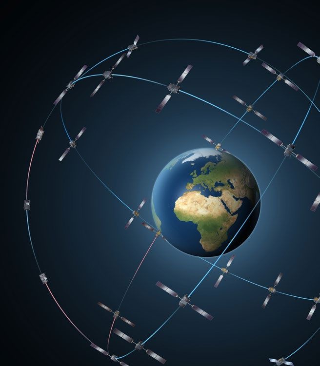
Europe’s Galileo constellation
Image: ESA-P. Carril10 Key EU space programmes post.parliament.uk
Box 4. Threats to GNSS
GNSS signals are typically transmitted with a power of about 50W from a
satellite that is orbiting the Earth at a distance of approximately 23,222km. 56,57
This means the signal is very weak when it reaches the Earth. Detecting such a
weak signal is challenging,4 and receivers can be vulnerable to interference in
a number of different ways:
• Jamming. On reaching Earth GNSS signals are weaker than background
noise and must be identified amidst the noise by numerical algorithms.
A receiver could become jammed and be unable to pick up a signal if
the background noise within the same frequency band as the signal is
too high. Jamming could occur accidentally, due to signals from other
sources, or deliberately, as jamming devices can be used to transmit noise
over the frequencies used by GNSS. It is a criminal offence to deliberately
jam GPS in the UK without a licence, although owning a jamming device is
not illegal.4,27,42
• Spoofing. The technical details of open GNSS signals are freely available
to allow manufacturers to develop receivers. However, these details can
be used to build devices, which transmit false signals that appear to be
genuine and hence deceive the GNSS receiver, causing it to calculate the
wrong time or position.4,42
• Meaconing. This is similar to spoofing but rather than the spurious signal
being entirely artificial it is created by rebroadcasting a genuine signal.
This causes a time delay and the receiver to record its position as the
position of the device that is rebroadcasting. Meaconing can be accidental
or deliberate.4
Anything that poses a threat to the satellite or receiver operation also
represents a danger to the GNSS system. For example, space debris could
damage a satellite, a receiver could malfunction or a cyberattack could
disrupt communication with the satellite. The signal itself is also vulnerable
as it travels from the satellite to the receiver. It could be disrupted by space
weather (POSTnote 361) or reflection off buildings.27,42
UK involvement in Galileo
UK industry and academia have been heavily involved in the development
of the Galileo system.58 UK expertise lies within both upstream activities
(building and developing the system itself) and downstream applications
(developing applications and services derived from the space-based
technology). Some examples of UK involvement in building the system
include:
• Surrey Satellite Technology Ltd (SSTL), in partnership with
German company OHB System, have built 22 payloads (the equipment
and instruments which fulfil the satellite’s function) for the Galileo
constellation to date and won a €140m contract to build eight more in
2017.59 This work is due for completion in 2020.6011 Key EU space programmes post.parliament.uk
• The largest supplier of security systems for Galileo is CGI UK
who have procured contracts worth over €100m.61 They have been
involved with designing encryption for the PRS and designing the ground
segment.
• Airbus Defence and Space in the UK were the prime contractor for the
Ground Control Segment of Galileo until 2018.62
• QinetiQ have been involved with the development of receivers for the
PRS system.63
• One of the Galileo Security Monitoring Centres was hosted by NATS
(National Air Traffic Services) Swanwick near Southampton.64 In 2018
this was moved to Spain in anticipation of the UK’s withdrawal from the
EU.65
Between 2000 and 2016 the UK contributed €1379m to the European
GNSS budget.27 This accounts for approximately 12.5% of the upstream
programme funding.27 UK industry has procured over 20% of all upstream
Galileo contracts.27 In 2018, the Government estimated that the potential
market for Galileo-derived applications and services could have a value of
€6bn by 2025.39
The future of position, navigation and timing in
the UK
A reliable source of PNT information is needed for critical national
infrastructure,4 and emerging technologies are likely to increase our reliance
on PNT in the future. For example, autonomous vehicles and drones must be
able to navigate, the internet of things (IoT) requires location information,
and the rollout of 5G mobile networks requires accurate timing and
position information (POSTbrief 32).4,5 The following sections outline future
PNT options for the UK, including a continued relationship with Galileo, a
sovereign UK system and alternatives to GNSS.
The future relationship between the UK and Galileo
After the transition period the Galileo open signal will continue to be freely
available to all, including users in the UK.66 From January 1 2021, individuals
and organisations in the UK with Galileo-enabled devices will not notice a
difference in the service.15 However, by default, the PRS signal will not be
available to users within the UK, and UK-based companies will not be able
to bid for new contracts to work on any aspect of Galileo.15 The Government
has suggested that exclusion of UK industry from Galileo could delay the
programme by 3 years and increase the cost by €1bn.58
In their initial negotiating position, the EU suggested that the UK could
negotiate access to the PRS signal. However, this agreement would not allow
the UK to participate further in the development of the PRS system.20 The12 Key EU space programmes post.parliament.uk UK Government have declined to consider an agreement where they cannot have access to the technical details of PRS as this would not allow them to guarantee its reliability or resilience. In their approach to negotiations, the UK Government does not make any provisions for a future relationship with the Galileo programme.19 Instead, they have expressed interest in pursuing a sovereign GNSS programme.24 A sovereign UK system In the absence of a deal to maintain access to Galileo it has been proposed that the UK could build its own GNSS system. Some stakeholders consider this preferable to continuing to rely solely on the American GPS system, as was done in the past. This is because a sovereign system would allow the UK greater autonomy and improved resilience if used in combination with GPS.23 However, critics suggest that the cost of a sovereign system cannot be justified if GPS is able to provide a sufficient service.67 In their 2020 manifesto, UKspace, the space industry trade body in the UK, recommended that the Government must secure participation in a GNSS programme, either through ESA or via a sovereign system, rather than relying solely on GPS in the future.68 The Government has already spent £92m on an initial 18-month feasibility study to look at the design and development of a UK system.24 In March 2020, the Financial Times reported that the publication of this study had been delayed by 6 months due to disagreements over the cost and scope of the project.69 In 2018, the Common’s Exiting the European Union Committee was told that the estimated cost of building a sovereign GNSS system would be £3–5bn and would take 4–5 years.67 It is estimated that the EU and ESA will have spent over €13bn on Galileo over the 21 years from definition of the programme in 1999 to planned completion in 2020.70 A UK sovereign system is forecast to be cheaper and quicker to build because the UK has gained expertise from its involvement in Galileo.67 However, some stakeholders have pointed out that the current total annual budget for the UK space agency is only £370m71 and there would also be significant running costs for a sovereign GNSS system. The EC have estimated that the running costs for Galileo will be around €800m annually.70 Alternative PNT technology A 2018 report, commissioned by the Government Office for Science, suggested that the UK is heavily reliant on GNSS but users generally lack an awareness of this dependence, so sufficient contingency plans for potential GNSS failure often do not exist.4 Although the likelihood of a total failure is low, the impact could be significant.27 Satellite navigation is not the only available source of PNT information.4 Many stakeholders highlight the importance of involving a wide range of technologies in the future UK
13       Key EU space programmes                                        post.parliament.uk

strategy for PNT, rather than relying solely or predominantly on GNSS,
to improve resilience.4,27,42,72–74 Emerging applications of PNT mean that
these alternative technologies may become increasingly necessary in the
future. For example, autonomous vehicles or drones will require a means of
navigating if they are in an area with poor satellite coverage.74,75

Different alternatives to GNSS may be suitable for different applications.4
When used in combination, different types of PNT can offer improved
accuracy and resilience. Examples of alternative PNT are given in Box 5. A
limitation of some alternatives to GNSS is that currently only satellite-based
PNT can offer global coverage.4

     Box 5. Examples of alternative PNT infrastructure
     Examples of other infrastructure that can provide PNT include:

     •     National Timing Centre. The UK currently relies on a single source of
           Coordinated Universal Time (the national time scale, UTC(NPL)) which
           comes from a group of atomic clocks hosted by the National Physical
           Laboratory (NPL) in Teddington.76 In February 2020, the Government
           announced that they would be investing £36m in the world’s first
           National Timing Centre (NTC) programme.72 The programme will be led
           by NPL and will develop a geographically distributed national timing
           capability. This will consist of multiple secure sites hosting atomic clocks,
           as well as access points at key locations across the UK. Access points
           will be deployed from 2023.77 These sites will be connected in multiple
           ways, including fibre, ground-based signal broadcast and satellite
           communications, as appropriate.78 The NTC will offer accurate, traceable
           and resilient measures of time and frequency that are entirely independent
           of GNSS.72
     •     eLoran (Enhanced long-range navigation). eLoran uses signals from
           ground-based radio masts to provide PNT information. The working
           principle is similar to GNSS in that the receiver triangulates the position
           by receiving signals from three or more masts.79 However, eLoran signals
           are stronger than GNSS and therefore less vulnerable to threats such as
           jamming.4 From 2012 to 2015, the UK General Lighthouse Authority used a
           prototype eLoran system to measure positions to better than 10m at UK
           ports, and a number of transmitters were operational in other European
           countries, forming a network, before being decommissioned in 2015.80 A
           single operational eLoran station in Cumbria is still able to provide UTC
           traceable time at a standard similar to GPS.81
     •     Satellites in low Earth orbit. Satellites in low Earth orbit (LEO), rather
           than the higher altitude orbits used by GNSS, may be used to provide
           a navigation signal.82–84 The commercially owned Iridium constellation
           (originally built for communications and the only LEO constellation with
           global coverage) has offered a PNT service since 2016.85 By virtue of
           being closer to Earth, the signal from these satellites is stronger but their
           proximity also means a larger number of satellites is needed to provide
           coverage – the Iridium constellation consists of 66 satellites.82 A stronger
           signal would improve resilience but the trend towards large satellite
           constellations in LEO contributes to increasing space traffic and debris.86
           These satellites share some vulnerabilities with GNSS such as space
           weather.
14 Key EU space programmes post.parliament.uk EGNOS: A satellite-based augmentation system Galileo is part of the European GNSS programme that is funded and managed by the EC.87 Also part of this programme is EGNOS (European Geostationary Navigation Overlay Service), the European satellite-based augmentation service (SBAS), which improves the accuracy and integrity of the US GPS signal over Europe.6 EGNOS consists of a space-based section and a ground-based section.88 On the ground there are reference stations at fixed, known positions. These record the GPS signal and forward it to a computing facility where the GPS calculated position is compared with the known position of the reference station. This comparison is used to compute the error in the GPS signal.89 The error measurement is then broadcast to the three geostationary satellites that make up the space section. These receive the correction to the GPS signal and broadcast it to receivers within the area with SBAS coverage. The receivers apply the correction to their own time and position measurements so the user benefits from higher accuracy.26 EGNOS is a regional system for Europe rather than a global system such as GPS or Galileo. It does not improve the accuracy of GPS outside of Europe. Other countries around the world have developed GPS augmentation systems for their own regions.6 As for Galileo, the basic EGNOS signal is free and open for use by all.88 Since 2011, EGNOS has also operated a more accurate safety of life service.90 This was primarily designed to support civil aviation by providing more accurate vertical positioning for use by aircraft when landing. However, it can also be used in other transport sectors to ensure that the GPS signal quality does not degrade below a certain threshold.90 EGNOS does not provide a GNSS signal of its own and so cannot be used in the absence of the GPS signal.26 UK industry and academia played a major role in developing EGNOS. For example, CGI UK was involved in building the system that validates the integrity of the EGNOS signal,61 and NATS Swanwick hosts some of the ground infrastructure for EGNOS.64 The UK Government’s initial position for negotiating a future relationship with the EU advocates continued cooperation with Europe on EGNOS.19 In the draft Air Transport Agreement published by the UK in May 2020, which proposes an initial legal text for negotiations, it states that UK users of air traffic management services will have ‘fair and equal access’ to EGNOS. However, this draft has not been agreed with the EU at the time of writing.91
15    Key EU space programmes                                        post.parliament.uk

COPERNICUS

Copernicus is the EU’s Earth observation (EO) programme. Satellites
are used to measure a wide range of physical, chemical and biological
parameters on the Earth’s surface and in the oceans and atmosphere.7 These
data are used for many applications, from monitoring climate change to
border security and agriculture (see Box 6 for more).8 The EU invested €4.3bn
in Copernicus from 2014–202092 and the EC has proposed spending a further
€5.8bn on the programme between 2021 and 2027.93 Parts of the programme
are also funded by ESA.94 Within the UK, Copernicus data are used across
Government (examples of departments include Defra, BEIS, MoD and DfID),
extensively in academia and also widely across industry.95–97 Defra leads
government policy on Copernicus while the UK Space Agency leads on space
infrastructure.98 UK industry and academia have been heavily involved with
development of the hardware and software used to deliver the programme.95

     Box 6. Applications of Copernicus data
     Copernicus data are widely used across a range of applications.8 Some specific
     examples of applications with relevance to UK policy include:
     • Pandemic monitoring. Environmental data from Copernicus can be used
         to monitor environmental factors that favour disease spread in humans,
         livestock or crops. For vector-borne diseases, such as malaria or West
         Nile virus, satellite data can be used to improve forecasts of spread (see
         POSTnote 597).102 Once an epidemic has occurred, data from Copernicus
         can be used to help monitor and contain further spread within a region.103
     • Flood monitoring and forecasting. Floods are the most frequently
         occurring natural disaster in Europe.104 Copernicus data are used for flood
         prediction and for monitoring existing floods and response coordination.
         In 2019, 80% of flooding events in Europe were forecast and mapped by
         the Copernicus Emergency Management Service, including the floods
         around Fishlake in South Yorkshire in November 2019.8,105
     • Air quality. The World Health Organization estimates that air pollution
         kills about 7m people every year (see POSTnote 458).106 In situ sensors
         provide good local measures of air pollution but the Copernicus
         Atmospheric Monitoring Service can provide regional measures. These
         can be incorporated into forecasting models and used to look at regional
         effects.103 Copernicus air quality data have been used to monitor pollution
         change in the UK and abroad as a result of the COVID-19 pandemic.107
     • Fishing regulation. Copernicus data contribute to maritime surveillance.
         Satellite images can be used to spot suspicious vessels or unauthorised
         fishing grounds. Estimates suggest that services derived from Copernicus
         data could increase the revenue of the European fishing industry by €3–5m
         by 2030.103
16 Key EU space programmes post.parliament.uk Technical overview Copernicus consists of three main parts: the space segment, the in situ component and service provision. For more general information on the science behind EO, see POSTnote 566. Space segment Instruments making continuous measurements from space are carried on dedicated satellites called Sentinels.108 Each satellite carries one or more instruments designed to fulfil a set of mission objectives.109 The first Copernicus satellite, Sentinel 1A, was launched in 2014.110 There are currently three pairs of Sentinel satellites and one single satellite in orbit. One further pair and two new sets of instruments are currently under construction.110 Each Sentinel mission uses pairs of satellites to increase spatial coverage over the Earth’s surface.111 The single satellite currently in orbit is Sentinel-5P, a precursor to Sentinel 5, which is dedicated to measuring air pollution.112 The three missions that are currently operational (Sentinels 1, 2 and 3) collect radar data, image Earth’s surface and monitor land and water properties.113–115 The forthcoming missions (Sentinels 4, 5 and 6) will measure the composition of the atmosphere, air quality and sea levels.116–118 Sentinel 6 consists of a satellite pair but Sentinels 4 and 5 are sets of instruments that will be carried by European meteorological satellites.119,120 Data from the Sentinels are supplemented by data from contributing missions (such as satellites owned by the intergovernmental European Organisation for the Exploitation of Meteorological Satellites [EUMETSAT] or private companies).121 The contributing missions provide complementary data. For example, they might fill gaps in the Sentinel data or provide higher resolution measurements over a particular area.110 The funding for the space segment is provided in two stages. The development stage, where the first pair of satellites (A and B) in each Sentinel mission are researched and built, is funded and managed by ESA. The second stage, where recurrent satellites (C, D, etc.) are built, is funded by the EU Copernicus programme.122,123 The operation of the Sentinels is also funded by the EU Copernicus programme. In situ component The in situ component makes localised measurements using instruments that are on the ground, in the sea or airborne. For example, ocean buoys, weather stations and soil samples may be used.124 As well as providing data in their own right, these measurements can be used to validate data from the space segment.125
17   Key EU space programmes                                  post.parliament.uk

Service provision
The Copernicus programme processes data to provide services to users
within six themes – atmosphere, ocean, land, climate change, emergency
management and security.126 For example, the emergency management
service uses land surface temperature data to identify areas of wildfire.127
The development and building of the space and in situ components
are carried out by upstream industries, whereas service provision is a
downstream activity.8

Copernicus data infrastructure
Sophisticated computing infrastructure is required to move, store and
analyse the large volumes of data produced by the Sentinel satellites.
General challenges associated with analysing large quantities of data were
discussed in POSTnote 468.

Data collected by the satellites are downloaded to ground stations where
it undergoes initial processing in near real-time.128 One of these ground
stations is located in Harwell in Oxfordshire.129 The data are currently
distributed from the ground stations by a dedicated network, which
transfers it to mission performance centres (MPCs) and processing and
archiving centres (PACs).129 MPCs are responsible for quality control and
PACs store the data and perform non-time-critical data processing.40

The data can be accessed by users through four different hubs and five
cloud-based services:
• Open access hub. This hub offers full, free and open access to all
    registered users.130 There are no restrictions on who can register as a
    user, but a maximum of two datasets can be downloaded simultaneously
    to ensure bandwidth is shared fairly.21 The other hubs allow a maximum
    of ten simultaneous downloads.21
• Collaborative hub. This hub enables countries participating in
    Copernicus to download data and distribute it to their users. This
    generally makes data transfer more efficient, as a state can download
    all data to a national site where internal users can access it. As a
    participating state, the UK has had access to the collaborative hub.21
• International hub. This hub is open to states outside the Copernicus
    programme who have signed an agreement with the EC. These
    countries can use the hub to download data to their national centres for
    redistribution. Current users include the US and Australia.21
• Services hub. This hub provides access to EU institutions and providers
    of the Copernicus services.21
• Data and Information Access Services (DIAS). There are currently five
    DIAS platforms that provide cloud computing and storage for Copernicus
    data. These were established by the EC to standardise data access and
    are currently available to all users, including those outside the EU.131 Data
    processing tools can be developed and shared on the cloud platform,
    removing the need for users to download large quantities of data.8 In
18 Key EU space programmes post.parliament.uk
2018, Sweden closed its collaborative hub access in favour of access to
data through DIAS.21
Data produced by the Copernicus programme are governed by a free and
open data policy.130 This means that Sentinel and in situ data are free of
charge at the point of access for anyone, including those outside of EU
member states. However, non-member states without an agreement with
the EC can only access data through the open access hub or DIAS, which
may not offer sufficient performance for some applications.21 Furthermore,
contributing mission data is not covered by the open data policy.
Distribution of data from contributing missions is governed by licences
agreed with the contributor which may not allow access by states outside
the EU.132
UK involvement in Copernicus
The UK was a founding member of the Copernicus programme and has been
involved in many different aspects of it, including building instruments for
the Sentinel satellites. Involvement in upstream activities has included:
• Sentinel 1: Astrium UK (now part of Airbus) built the central radar
electronics for Sentinel 1.133
• Sentinel 2: UK companies contributed batteries and some imaging
equipment to Sentinel 2.134
• Sentinel 3: RAL Space calibrated the device for measuring sea and land
surface temperatures on board Sentinel 3,135 and a UK-based team at
Airbus contributed a cooling system.136
• Sentinel 5P: Airbus Defence and Space UK was the prime contractor for
Sentinel 5P.137
• Data infrastructure: The UK hosts the processing and archiving centre
(PAC) for Sentinel 1 and 2 data in Newport.129 This facility is run by Airbus
UK via an ESA contract. Algorithms for Sentinel 3 and Sentinel 5P have
been provided by scientists in the National Centre for Earth Observation
(NCEO) and other research bodies.138,139
UKspace has estimated that the UK has received about 20% of the total
Copernicus budget for service provision during the funding period of 2014–
2020.122 The UK has made contributions to each of the six service themes,
examples include:
• Atmosphere. The atmosphere service is managed by the European
Centre for Medium-Range Weather Forecasts (ECMWF), which is based
in Reading.140 The UK Met Office, academia and industry carry out data
processing for the atmosphere service to produce products such as air
quality forecasting apps for mobile phones.141
• Climate change. The climate change service is also managed by
ECMWF. Since 2014, Copernicus has created 50 new UK-based jobs
at ECMWF.122 Academia, industry and the Met Office are involved in19 Key EU space programmes post.parliament.uk
developing climate change services, including seasonal weather
forecasts.142
• Marine. The Met Office, industry and academia are involved in the
marine service, producing datasets that can be used for planning marine
renewable energy programmes or responding to oil spills amongst other
things.143
• Land. The main product of the land service is mapping of land use and
natural features for a range of applications, such as agriculture or
ecosystem modelling.144 UK academia and industry played a role in the
initial development of these services and academia continues to play a
role in the operational service.122
• Emergency Management Service. UK industry provides mapping
services for the preparedness and recovery parts of the emergency
service.122 These maps are used to monitor and respond to events such as
flooding and forest fires in Europe.105
• Security Service. UK industry led the development of part of the border
security service.145
The UK hosts two national `mirror sites’ to support the dissemination of
large quantities of Sentinel data to UK users.21 These mirror sites copy
large quantities of Copernicus data via the collaborative hub and this is
subsequently disseminated to UK users. This reduces traffic on the central
Copernicus hubs and makes data access more efficient. One of the mirror
sites is funded by the Natural Environment Research Council (NERC) and
operated by the NCEO at RAL Space in Oxfordshire and the intended
audience is academic users.146 The other accesses data through Airbus in
Farnborough, Hampshire and is principally intended for commercial users. It
is managed by the Satellite Applications Catapult.147
The future of Earth observation for the UK
There is continuing uncertainty about the relationship the UK will have with
Copernicus following the transition period.19 Some existing UK interests in
the EO sector will be supported by continued membership of international
bodies such as ESA and ECMWF.25,148 However, without an agreement with
the EU, the UK could lose high performance data access and commercial
opportunities.15 The following section considers the UK’s future requirements
for Earth observation and how these might be met by Copernicus or other
programmes.
UK requirements for Earth observation
The Government updated their 10-year Earth observation strategy at the
end of 2019 and expressed a vision of the UK becoming a world leader in
new EO technologies within 10 years.96 To meet this goal, stakeholders
agree that access to high quality Earth observation data is necessary, as is
maintenance and development of EO expertise in the UK. UK expertise within20 Key EU space programmes post.parliament.uk the space sector is developed by participating in missions and this can be done nationally or through international collaborations.11,95 Data access hinges not only on data production, but also the availability of infrastructure to store, process and disseminate the data.149 Building data infrastructure for the large quantities of data produced by EO is challenging.150 An increasing focus on policies to combat climate change and a need to mitigate the effects of climate change are likely to increase demand for EO derived products.8 The future of Copernicus The next EU funding period for Copernicus begins in 2021 and will last until 2027.110 Plans for developing the space component involve both an expansion of current capabilities through the addition of new Sentinels and an upgrade of Sentinels 1–6 to the next generation (such as replacing satellites A and B with satellites C and D).151 Deployment of the expansion satellites is expected to begin in 2025 and the first of the next generation Sentinels will be launched between 2030 and 2032.151 Contracts for the next generation will be procured through the EU and the first expansion satellites will be procured via an ESA process, on behalf of the EU.123 The expansion of the Sentinel family is centred on six high priority candidate missions. These include instruments that will measure the properties of sea ice,152 and carbon dioxide from human activities,153 both important parameters for understanding climate change. There is also a mission to measure land surface temperature, which will help to manage water supplies and monitor natural disasters such as fires and volcanic eruptions.154 In addition, there are missions designed to monitor soil moisture, soil types and vegetation that will support agriculture and biodiversity monitoring.155,156 It is likely that the Copernicus free, full and open data policy will remain in place for the foreseeable future.157 A study investigating potential alternative data policies for Copernicus after 2020 concluded that the free, full and open data policy was more beneficial than alternative options of restricting data access, charging for data access or limiting redistribution rights.150 This view is also supported by the European EO downstream industry,158 and Nitrogen dioxide the intergovernmental Group on concentrations over India Earth Observations.159 Data access Image: contains modified restrictions could be imposed on Copernicus Sentinel data the basis of legal requirements (2019-20), processed by ESA, for data protection, security CC BY-SA 3.0 IGO
21   Key EU space programmes                                 post.parliament.uk

requirements or technical challenges.150 Technical challenges could become
an issue if demand for data exceeds the capacity of the data distribution
infrastructure.150 The infrastructure has evolved significantly over the
programme’s lifetime and will probably continue to do so, but demand is
also likely to increase, as will volumes of data.110 The processing of the data
is likely to benefit from the growth of advanced computing techniques, such
as machine learning and cloud computing.160–163

The future relationship between the UK and Copernicus
After the transition period, the UK will cease full participation in Copernicus
by default (though it will maintain some access to the programme via
membership of ESA and other non-EU organisations). This means that UK
companies would not have access to contracts tendered by the EC.15 UK
companies have been able to bid for the high priority candidate mission
contracts as they are development stage contracts managed by ESA.122
However, if the UK wins any of these bids, they will not be able to continue
working on the recurrent models or other EU funded aspects of the contracts
without negotiating full access to the Copernicus programme as a third
party.123 Industry stakeholders have expressed concerns about this, as the
contracts for recurrent satellites involve effectively rebuilding an existing
satellite. This provides better returns than researching and developing a
completely novel technology.96,122 It may also be more difficult or unviable for
UK industry to participate in ESA research and development contracts if the
follow-on work has to be moved to an EU member state.123 The UK academic
community may also lose the opportunity for scientific and technical
leadership on these missions.15

If the UK leaves the Copernicus programme, access to some types of data
and high bandwidth data access may be lost.15 Access to most Copernicus
data would still be available because of the free and open data policy.130 The
open access hub and DIAS could provide the infrastructure for UK users to
access this data in the absence of an agreement between the UK and the EU.
However, some stakeholders have expressed concerns that the performance
of these systems may not meet UK demand and user requirements. They
advocate government investment in national data facilities.21 The future of
the UK-based mirror sites accessed through the collaborative hub and the
UK-based processing and archiving centre is uncertain and will depend on
what is negotiated by the EU and UK.21 It is still possible for the UK and the
EU to come to an agreement that would allow the UK to participate in the
programme to a greater degree than the default.19

In the Government’s outline of their approach to negotiations with the EU
they state that they would consider a deal that allows the UK to participate
as a third party in Copernicus.19 This would probably require the UK to
provide a funding contribution to the programme. Iceland and Norway (both
within the European Economic Area but not EU member states) provide
funding for Copernicus and are able to fully participate in the programme in
22   Key EU space programmes                                 post.parliament.uk

return.22 The EC recommendation for opening negotiations with the UK does
not explicitly mention Copernicus.20 However, it does express openness to
allowing the UK to participate in, and contribute to, some EU programmes,
including the space sector explicitly. UKspace has expressed a strong
preference for the UK to negotiate sustained membership of the Copernicus
programme.122 Copernicus data and development of Sentinel satellites and
instruments is a significant part of the Earth observation sector in the UK.96
The sector is growing rapidly with an average annual growth rate of 25%
from 2015–2017.95

An alternative to a deal securing full participation is that the UK may
be able to contribute in-kind to Copernicus by investing in national EO
capabilities and offering data from these to the EU programme as part of an
exchange.122 A bilateral programme with another nation or taking the lead
on an ESA programme could also be an alternative.95 Developing a national
programme could help to maintain and grow EO expertise within the UK.164
However, it would take time to develop and deliver a new programme that
could contribute to Copernicus.

Making an in-kind contribution would probably not allow the UK any
influence in the governance or development of Copernicus.122 One particular
issue with this is that Copernicus satellites can be programmed to prioritise
specific geographic locations for data collection.165 If the UK was not involved
in the programme’s governance, data collection in line with UK interests may
not be prioritised.166 This could result in reduced data quality over the UK
and dependent territories for applications such as emergency response and
agriculture.122

The UK space industry favours a combination of these solutions: securing
full participation in Copernicus, maximising the UK’s participation in ESA
programmes and developing a national programme with opportunities for
bilateral agreements with other nations.68

Other Earth observation programmes
The UK is currently involved in several other Earth observation
programmes.95 In general these programmes consist of a single satellite
designed to make measurements of a specific feature of the Earth (see
examples in Box 7). Therefore, their individual remit is much narrower than
that of the Copernicus programme and this is reflected in smaller budgets,
shorter operating timescales and more limited production of data. Due to
the cost and substantial infrastructure of Copernicus, stakeholders agree
that it would not be feasible for the UK to pursue a national replacement of
Copernicus.

Alongside extensive involvement in ESA programmes (Box 7), the UK
collaborates internationally on several other EO initiatives. The UK is a
member of the Committee on Earth Observation Satellites (CEOS) which
23    Key EU space programmes                                          post.parliament.uk

coordinates international, civil EO programmes and encourages data
sharing between programmes across the world.167 Since 2014, the UK and
France have had a bilateral agreement that has seen collaboration across a
number of missions monitoring weather and climate.95

     Box 7. Ongoing UK/ESA EO missions
     Much of the UK’s international work is in collaboration with ESA.95 Some
     examples of current and future research missions the UK is leading in
     collaboration with ESA are:
     • CryoSat. CryoSat is an ESA mission that was proposed and led by UK
          scientists at University College London.168 CryoSat was successfully
          launched in 2010 and continues operations at the time of writing.169 The
          mission aims to measure changes in ice sheet thickness and how this
          contributes to sea level rise.
     • TRUTHS. TRUTHS is a climate mission conceived by NPL, proposed by the
          UK Space Agency and recently accepted for implementation by ESA.170
          TRUTHS will measure the energy balance of the Earth to high accuracy.
          These data can also be used for in-space calibration of measurements
          from other satellites (as opposed to comparing with in situ data).171 Climate
          change is driven by changes in Earth’s energy balance,172 and so an
          accurate measure of this enables better understanding of climate models
          and more informed policy decisions.95
     • Aeolus. Aeolus is an ESA mission for which Airbus UK was the prime
          contractor.173 It carries an instrument that measures wind velocity through
          the atmosphere. These measurements are already being used by ECMWF
          in their forecasts and have been found to improve them.174
     • Biomass. This is an ESA mission, led by a UK scientist at the University
          of Sheffield and NCEO, for which Airbus UK are the prime contractor. It
          is due for launch in 2022.95 The mission aims to measure changes in the
          biomass of the world’s forests over multiple yearly cycles. This will feed
          into understanding of carbon uptake by forests, land use change and
          deforestation.175

EU SPACE SURVEILLANCE AND
TRACKING (EUSST)

EUSST is the EU’s programme for surveying and tracking man-made space
debris in orbit around the Earth.9 A collision with a piece of space debris
can be fatal for a satellite and thus space debris presents a danger to the
infrastructure that relies on space, for example PNT, Earth observation
and telecommunications (space debris was covered in POSTnote 355). The
need for safeguarding these critical services from hazards in space was
acknowledged by the National Space Security Policy in 2014,176 and the
24 Key EU space programmes post.parliament.uk
Strategic Defence and Security Review of 2015.177 Space debris can also
present a danger to humans on the Earth’s surface as large pieces can re-
enter the atmosphere and fall to the ground.178
The amount of space debris in orbit is increasing for a number of reasons:
• Satellites are launched into space continuously. The number
of objects being launched is increasing rapidly due to advances in
technology which reduce cost as well as current trends towards the
launch of satellite constellations.86,179
• The age of the existing satellite population is increasing. Satellites
near or past the end of their working life that are not properly disposed
of are more likely to break up and produce debris.180
• As space becomes more congested the risk of collisions becomes
higher. A collision between working satellites or debris can produce
further fragments of debris.180,181
By surveying and tracking potentially dangerous pieces of debris, satellite
operators can be warned in advance of a potential collision so that they can
reposition their satellite out of harm’s way.182 Currently, debris down to a size
of about 10cm can be tracked but smaller fragments can also cause damage
(see Box 8 for an example).10
The EUSST consortium was set up in 2014 by the UK and four other EU
member states (France, Germany, Spain and Italy).183 In 2018, Poland,
Portugal and Romania joined as members.10 EUSST has been partly
operational since July 2016.10 The consortium aims to improve European SST
capabilities by combining the SST capabilities of the participating states and
centralising data cataloguing.184 The services of the programme are provided
to all EU member states, not only those involved in the consortium.183
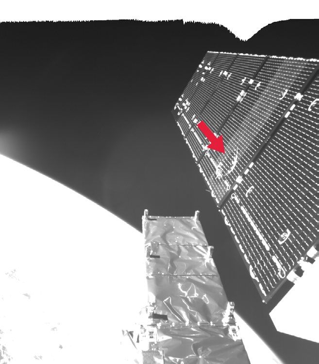
Box 8. Collision of Sentinel 1A with space debris
On 23 August 2016 a sudden power reduction and a slight change in position
of the satellite was measured onboard Sentinel 1A, one of the Copernicus
programme satellites.185 Engineers at ESA assessed that the drop in power was
probably caused by the collision of a particle, a few millimetres in size, with
one of the satellite’s solar panels. This size of particle is too small to be tracked
by radar and optical telescopes but can still cause damage, because they
travel at very high speeds.186 The drop in power onboard the satellite was not
large enough to significantly affect operations.18525 Key EU space programmes post.parliament.uk Technical overview The EUSST programme uses ground-based sensors to collect data on space debris and active satellites.10 These data are then processed so that warnings and advice services can be provided to EU member states. Data collection The data for EUSST are collected by radars, telescopes and laser ranging stations.10 Laser ranging measurements are taken by sending a laser pulse towards a satellite. This pulse is reflected back and the time the reflection takes to arrive is measured. Using the fact that the laser pulse travels at approximately the speed of light, this time interval can be used to calculate a distance, giving the satellite’s position up to millimetre precision. Laser ranging can be used to track objects orbiting at altitudes of 300km to 42,000km.187 Survey radars are used to keep watch of the sky for potentially hazardous debris. If a hazard is spotted, its orbit is tracked by radars, telescopes or laser ranging. Radars are useful for tracking fragments in low Earth orbit (less than 2000km altitude) because they allow continuous observations (optical telescopes on the ground are only useful at night), have high sensitivity and are less affected by atmospheric conditions.188 Optical telescopes are generally more useful for detecting objects in higher orbits as radars need to be very powerful to detect these far away objects. There are very few sufficiently powerful radars in existence, and they come at great expense.189 Most of the existing sensors are provided by member states and are often repurposed from other applications.10 For example, the UK contributes data from the Chilbolton radar in Oxfordshire to the project. This radar was originally designed for studying atmospheric physics.190 However, currently, most of the data for EUSST comes from the US SST programme rather than the European sensors.184 By measuring the position, speed and size of a debris fragment its orbital parameters can be calculated and used to predict where the debris will be in the Sentinel-1A impact near future. This calculation can Image: ESA
You can also read