KIMBERLEY BEAR AWARE Risk Assessment for Bear/Human Conflict in Kimberley, British Columbia
←
→
Page content transcription
If your browser does not render page correctly, please read the page content below
Risk Assessment   1

KIMBERLEY BEAR AWARE

Risk Assessment for Bear/Human Conflict in
       Kimberley, British Columbia

          Prepared by Robert Newell

               November, 2007
Risk Assessment    2

                                              Preface

       The Kimberley division of Bear Aware has prepared a report assessing the risk of

bear/human conflict occurring in various areas of Kimberley, BC. The purpose of the report is to

aid future Bear Aware (or related agencies) initiatives by providing insight on how to achieve the

most effective geographical allocation of bear management strategies (i.e. public education,

outreach, waste management) within Kimberley. In addition, the report discusses the potential

for certain areas to experience future increases in bear activity in due to rapid rates of urban

development.

       The report begins by providing background on the Bear Aware program and how it

operates with specific reference to the Kimberley division. The report then describes general

trends in bear activity for the last three years within Kimberley (and surrounding area). The

subsequent section and the bulk of the report qualitatively assesses the risk of bear/human

conflict occurring in various regions in Kimberley. The report concludes with figures displaying

fruit tree (i.e. bear attractants) densities throughout Kimberley.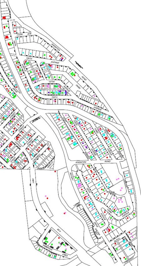
Risk Assessment   3

Table of Contents

Risk Assessment   4

List of Tables
Risk Assessment   5

List of Tables
Risk Assessment      6

                                           Background

       The Bear Aware Program is committed to reducing human/bear conflict from a

preventative angle. More specifically, Bear Aware aims to reduce the amount of bears that rely

on human products for food and (consequently) are aggressive toward people. Bear Aware

achieves reduction in conflict through the use of waste management policies, public outreach,

educational programming, and volunteer-based projects. Essentially, the Bear Aware Program is

a bear management initiative that operates via altering human behaviour in a manner that favours

a reduction in human/bear conflict.

       Bears are omnivorous with an appetite for a wide variety of foods and will consume

items such as insects, fruit, roots, seeds, fungus, rodents, carrion, etc. A bear needs to maximize

caloric intake to sustain his/herself and prepare for the slumbering season in the winter. Since a

bear’s diet is incredibly varied, many human products have the potential to attract a bear. Bears

have a sense of smell approximately 7 times more sensitive than a greyhound’s; therefore, a

resident in a bear-inhabited region should not overestimate the power a potential attractant has

for enticing a bear. A bear that succumbs to the temptation of an attractant can quickly become a

“problem bear” (a bear that is habituated to people and reliant on human products) and may

choose to reside in human territory. Problem bears can show aggression toward people because

they may view humans as nuisances in their feeding areas.

       The objective of the Bear Aware program is to prevent bears from residing and feeding in

human populated areas (i.e. occurrences of problem bears). Bears that forage in natural areas

will live healthier lifestyles and are less likely to be involved in conflict with humans.

Kimberley Bear Aware achieves its objective when bears that enter the city of Kimberley

promptly leave without interest of loitering or feeding within town.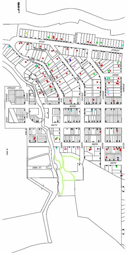
Risk Assessment     7

       Since the establishment of the Bear Aware program approximately 7 years ago (in 2000),

Kimberley has experienced a substantial reduction in human/bear conflict. In the late 90s, over

60 bears were eliminated in the Kimberley area due to the threat they posed to humans. Through

the efforts of Bear Aware and allies in bear management, the numbers of exterminated problem

bears has dramatically decreased.

       Problem bear exterminations have decreased from the days before Bear Aware was

implemented in Kimberley; however, the number of exterminations have been relatively (to

other Bear Aware years) high over the last two years. In 2007, one bear was exterminated on-

site and eleven bears were trapped. In 2006, six bears were eliminated on-site and four bears

were trapped. In previous Bear Aware years, exterminations generally ranged from zero to ten.

       The increase problem bear exterminations could be attributed to climate change and

influx of seasonal residents. Climate change has brought about particularly dry summers over

the last two years in the Kootenays (especially in 2007). Dry summers cause poor moisture

conditions in natural areas leading to a low yield of wild fruit crops. In seasons of scarcely

available natural fruit, bears have less in the way of natural foods to sustain themselves and, thus,

are more likely to rely on human products for sustenance. To lesser degree, part of the increase

in bear activity could be attributed to increased construction of new housing developments which

may attract seasonal residents that are not entirely familiar with proper methods for coexisting

with wildlife. However, Bear Aware does have initiatives that educate many of the seasonal

residents and, currently, increase in bear/human conflict caused by influx of temporary residents

is relatively minor.

       Albeit 2007 exterminations of problem bears were higher than in other Bear Aware years,

problem bear deaths in Kimberley could be considered low in relation to other Kootenay

Mountain communitys (such as Creston). Bear activity was particularly high throughout the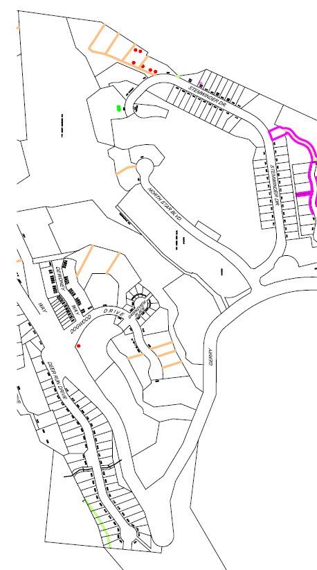
Risk Assessment       8

Kootenays this year; therefore, the numbers of problem bear exterminations potentially could

have returned to levels equal to (or higher than) those of late 1990s. Conclusively, even though

problem bear exterminations have been relatively high in Kimberley in the last two years, the

presence of Bear Aware appears to reduce the potential for occurrences of problem bear

incidents and, thus, reduces risks of bear/human conflict.
Risk Assessment       9

       Bear Incident Report Trends Observed over the Last Three Years

       The majority of the trend data has been compiled from reports archived in the Ministry of

Environment (Cranbrook, BC). Some of the data reflect sightings that have been reported to the

local RCMP offices, the City of Kimberley, and Kimberley Bear Aware.

Monthly Trends in Bear Incidents

       As would be expected, the highest number of bear incident reports occurred during the

fall seasons (late August to October) of the last three years. Generally speaking, bear activity is

highest in fall because bears are increasing their caloric intake in preparation for their winter

sleep. Bear activity in Kimberley appears to cease in late-November/early-December because

bears have entered their dens. Residents of Kimberley should prepare for an impending increase

in bear activity during the spring and summer months (i.e. prune trees).

       Bear incidents were particularly high during September in 2007. Table 3 displays the

highest monthly number of bear incident reports occurred in September, 2007 (n=55). As

mentioned in “Background”, much of the increased bear activity can be attributed to the dry

summer and poor yield of wild fruit crops. During late August, domestic apple trees begin to

produce fruit; therefore, bears are enticed to feed on domestic fruit due to lack of natural foods.

Consequently, residents of Kimberley should be extra careful when managing bear attracts

during a year with an especially dry summer.

       Reported bear incidents decreased in October, 2007, which was a phenomenon noted in

other areas of the East Kootenays (such as Fernie). The decrease in activity correlated with an

increase in precipitation; however, whether higher precipitation is the direct cause of reduction in

in-town bear activity is uncertain.
Risk Assessment 10

Table 1. Number of bear incidents reported monthly in 2005.

                     100

                      90

                      80

                      70

                      60
       Reports (%)

                      50

                      40

                      30

                      20

                      10

                      0
                           Apr   May   Jun    Jul     Aug       Sep      Oct        Nov
                                                 Month

Figure 1. Histogram display monthly percentages of bear incident reports in 2005.
Risk Assessment 11
Table 2. Number of bear incidents reported monthly in 2006.
100
90
80
70
60
Reports (%)
50
40
30
20
10
0
Apr May Jun Jul Aug Sep Oct Nov
Month
Figure 2. Histogram display monthly percentages of bear incident reports in 2006.Risk Assessment 12
Table 3. Number of bear incidents reported monthly in 2007.
100
90
80
70
60
Reports (%)
50
40
30
20
10
0
Apr May Jun Jul Aug Sep Oct Nov
Month
Figure 3. Histogram displaying monthly percentages of bear incident reports in 2007.Risk Assessment 13
Nature of Bear Incidents
The majority of reported bear incidents over the last three years involved bear sightings
without any form of conflict occurring (categorized as “Bear Sightings”). The next most
common type of reported bear incident is categorized as “Nuisance Wildlife” which refers to
bears that are feeding upon human products or are spending an abnormal amount of time on
human property. Other types of bear incidents were reported in relatively low numbers
The number of reported nuisance wildlife incidents has increased over the last two years
(from 2005); however, proportions of nuisance wildlife reports to total reports are relatively
similar from 2005 to 2007. Therefore, nuisance wildlife incidents likely have increased over the
last two year simply because the amount of bears in-town has increased. The increase of bears
foraging in-town is a probable result of the recent scarcity in wild fruit (previously discussed).
The number of reported trapped bears increased in 2007. Bear traps are set by
Conservation Officers when bears have visited a human property repeatedly and, thus, are
displaying fidelity to the property. Bear Aware often provided advice on how to manage or
remove attractants to terminate repeated visits from a bear to residents experiencing reoccurring
bear issues, and, in most case, bears vacated areas where food was no longer available.
However, on occasion, a bear will continue to return to an area even when food products are
inaccessible to him/her. In cases such as these or when bears are noted to be particularly
aggressive, traps are set. The majority of trapped bear incidents (over the last three years)
occurred in September, 2007. Some of the bears (before trapped) continued to visit an area even
after multiple failed attempts at accessing a food source (i.e. trying to open a garbage bin). Such
desperation in foraging efforts is indicative of scarcity in wild food sources.Risk Assessment 14
Table 4. Nature of bear incident reports in 2005.
100
90
80
70
60
Reports (%)
50
40
30
20
10
0
Injured Wildlife Nuisance Wildlife Orphaned Property Damage Sighting Wildlife in Trap
Wildlife
Nature of Report
Figure 4. Histogram displaying percentages of the nature of the bear incident reports in 2007.Risk Assessment 15
Table 5. Nature of bear incident reports in 2006.
100
90
80
70
60
Reports (%)
50
40
30
20
10
0
Aggression Injured Nuisance Property Sighting Wildlife in
Wildlife Wildlife Damage Trap
Nature of Report
Figure 5. Histogram displaying percentages of the nature of the bear incident reports in 2006.Risk Assessment 16
Table 6. Nature of bear incident reports in 2007.
100
90
80
70
60
Reports (%)
50
40
30
20
10
0
Nuisance Wildlife Sighting Aggressive Wildlife Wildlife in Trap
Nature of Report
Figure 6. Histogram displaying percentages of the nature of the bear incident reports in 2007.Risk Assessment 17
Attractants Noted at Sites of Bear Incidents
The vast majority of reported bear incidents do not note any observable bear attractants
within the vicinity of the incident. The lack of identification of bear attractants in a bear incident
report does not necessarily mean the site of the incident is devoid of attractants because, perhaps,
vicinal attractants were located in an unobservable area. However, for the purposes of the
current report, the “None Mentioned” category will refer to reported incidents where a bear has
not been enticed by a human product such as garbage or domestic fruit. Such an assumption
about the “None Mentioned” category is fairly safe because the presence of most fruit trees is
noticeable and garbage that has been accessed by a bear is obvious (because the garbage is
strewn about the site of the bear incident).
The item that appears to most frequently attract bears is garbage indicating a major cause
of problem bear occurrences is unsecured waste. Kimberley operates under a bylaw stating
garbage must be secured (i.e. indoors or in a bear resistant container) until the morning of
garbage pick-up. Residents that do not comply with the bylaw are allowing waste to be
accessible to bears; thus, bears may associate such residents’ properties with easily accessible
food. Situations of bears feeding upon waste items often occur in neighbourhoods with newer or
seasonal residents of Kimberley that are unfamiliar with proper waste management strategies.
Report incidents of bears feeding on garbage have decreased in the current year (from 2006);
therefore, public education strategies concerning waste management may have a significant
impact on new and seasonal residents.
Fruit trees are the next commonly noted attractant. Most reports involving fruit attracting
bears occur during the fall when trees are producing fruit and bears are particularly hungry.
Residents should be advised to prune fruit trees in the summer to avoid enticing hungry bears
during the fall.Risk Assessment 18
Table 7. Attractants noted at sites of reported bear incident in 2005.
*Some callers noted more than one attractant; thus, n does not equal 41*
100
90
80
70
60
Reports (%)
50
40
30
20
10
0
BBQ Freezer Fruit Trees Garbage None Mentioned
Attractant Noted
Figure 7. Histogram displaying percentages of attractants noted at the sites of reported bear
incidents in 2005.Risk Assessment 19
Table 8. Attractants noted at sites of reported bear incident in 2006.
*One caller noted more than one attractant; thus, n does not equal 118*
100
90
80
70
60
Reports (%)
50
40
30
20
10
0
Bird Feeders Food Freezer Fruit Trees Garbage Hunter Kill None Pet Food
Mentioned
Attractant Noted
Figure 8. Histogram displaying percentages of attractants noted at the sites of reported bear
incidents in 2006.Risk Assessment 20
Table 9. Attractants noted at sites of reported bear incident in 2007.
*One caller noted more than one attractant; thus, n does not equal 124*
100
90
80
70
60
Reports (%)
50
40
30
20
10
0
Compost Fruit Trees Garbage Hunter Kill None Pet Food Smokehouse
Mentioned
Attractant Noted
Figure 9. Histogram displaying percentages of attractants noted at the sites of reported bear
incidents in 2007.Risk Assessment 21
Actions Taken in Response to Bear Incidents
No advice was provided to the caller on how to avoid or reduce bear/human conflict in
response to most of the reports collected and archived by the Ministry of Environment. Advice
was not usually provided because the majority of reported bear incidents involved only sightings.
Because of Kimberley’s proximity to forested area, bears are expected to wander within town.
Concerns about bear activity arise when a bear wanders into town repeatedly and/or when a bear
decides to stay within town because they discover available food. Consequently, bear sightings
often are collected solely for the purpose of monitoring bear activity and advice is not provided
unless evidence exists that the sighted bear is or is becoming a problem bear.
On occasion, bear reports are referred to the Conservation Officer Service. Such an
action is taken when the bear involved in the report has become a potential threat to human
safety (i.e. habituated and aggressive). The amount of reports referred to Conservation Officers
has increased from 2005. Since bears have been searching for alternatives to the scarce natural
food sources over the last two years (see “Background”), a higher number of bears have been
foraging in-town. A bear that frequently forages in human territory poses a threat to humans
because a higher potential exists that a person will agitate the bear. Therefore, Conservation
Officers are contacted to respond accordingly to such threat.
Bear Aware is contacted in response to some bear incidents. Bear Aware responds to
bear incidents through non-lethal methods such as providing advice and/or facilitating attractant
removal. Many bear incident reports were delivered or referred to Bear Aware in 2007 which
indicates the community of Kimberley supports Bear Aware because the community is willing to
involve Bear Aware in bear management issues.Risk Assessment 22
Table 10. Responses to bear incident reports in 2005.
100
90
80
70
60
Reports (%)
50
40
30
20
10
0
Referred to CO RCMP Attended Advice Provided No Advice Provided
Action Taken
Figure 10. Histograms displaying percentages of actions taken in response to reported bear
incidents in 2005.Risk Assessment 23
Table 11. Responses to bear incident reports in 2006.
100
90
80
70
60
Reports (%)
50
40
30
20
10
0
Referred to Bear RCMP Attended Referred to CO Advice Provided No Advice Provided
Aw are
Action Taken
Figure 11. Histograms displaying percentages of actions taken in response to reported bear
incidents in 2006.Risk Assessment 24
Table 12. Responses to bear incident reports in 2007.
100
90
80
70
60
Reports (%)
50
40
30
20
10
0
Referred to Bear Referred to CO RCMP Advice Provided No Advice Provided
Aw are
Action Taken
Figure 12. Histograms displaying percentages of actions taken in response to reported bear
incidents in 2007.Risk Assessment 25
Risk of Bear/Human Conflict in Various Areas of Kimberley
Table 13. Number of reported bear incidents occurring in various areas of Kimberley over the
last three years.
Table 14. Percentages of total reported bear incidents occurring in various areas of Kimberley
over the last three years.Risk Assessment 26
Townsite
Townsite is the northern most neighbourhood of Kimberley. The majority of the area
consists of residential housing; however, a school, a clinic, a retirement home, and a visitor
gardens also are located within Townsite. Lois Creek Park is located near the northern end of
Townsite which essentially consists of a forested area intersected with walking trails.
Townsite experienced the second highest level of reported bear activity during 2007 (see
Table 14). A high risk of human bear conflict is associated Townsite because of the area
contains a high density of human dwellings in close proximity with forested area. Essentially,
Townsite is a residential zone surrounded by forest; therefore, the area has low vehicular traffic
allowing bears to enter frequently without being deterred by automobiles. Furthermore,
Townsite contains many residences; thus, a high potential human products (such as fruit trees
and garbage) will be made available to bears is associated with the area.
Three areas of particular concern exist within Townsite:
Lindsay Park Elementary School is located next to a gully where multitudes bears
have been observed, and several of the residents near the school have fruit trees
on their property. The proximity of the gully and fruit trees to the school is of
concern because bears may be tempted (by fruit) to enter the vicinity of playing
children. In 2007, Bear Aware has worked with volunteers to remove fruit from
the trees near Lindsay Park Elementary; however, a bear was trapped (before fruit
removal) near the school due to the threat the animal posed to children.
Lois Creek Park is ideal black bear habitat because the park is forested with trees
sparsely enough distributed that shrubs (associated with items bears like to eat)
receive enough sunlight. The park is directly adjacent to residential
neighbourhoods; therefore, park trails often are used by local residents.Risk Assessment 27
Consequently, a potential for park patrons to startle and agitate bears residing
within Lois Creek Park exists.
Cominco Gardens is a tourist attraction open to the public without an admission
price. The gardens are surrounded by a forested area and many waste receptacles
are located on the grounds; therefore, bears often are enticed from the forest into
Cominco Gardens by garbage odours. A retirement home and a clinic are located
on either side of Cominco Gardens; therefore, a risk of the elderly and infirm
coming in contact with a bear enticed by garbage exists.
The majority of Townsite residents are familiar with strategies for keep wildlife from
entering their property; however, Bear Aware attended (in 2007) several incidents where newer
residents have made food items accessible to bears. New residents of Townsite often have
moved from urban environments (i.e. Vancouver, Calgary); therefore, many were unfamiliar
with practices used for coexisting with wildlife. Whether Townsite will experience a large influx
of people moving from urban settings in the future is uncertain; however, if such a trend does
occur, bear/human conflict could continue to increase in the area.
Ski Hill
The ski hill has the highest elevation of the developed areas in Kimberley. The ski hill is
the site of the Kimberley Alpine Ski Resort and many new seasonal home developments. Very
few permanent residences are located on the ski hill.
Between 5 % and 7 % of total bear incident reports over the last three years have
involved bear activity on the ski hill (see Table 14). The number is low relative to the size of the
area, and, currently, the ski hill is not associated with a high risk of bear/human conflict because
the majority of human traffic in the area occurs during the winter when bears are within theirRisk Assessment 28
dens. However, the risk for bear/human conflict on the ski hill will increase in future years due
to a high rate of temporary housing development. As more temporary and seasonal homes are
created and purchased, temporary residents will begin to visit Kimberley’s ski hill during
summer and fall months more often than in previous years. Temporary residents often are
visiting from urban environments (such as Calgary) and, thus, may be unfamiliar with practices
used for coexisting with wildlife. Furthermore, temporary residents may visit Kimberley for
short periods of time on weekends; therefore, they may not be present for the ski-hill’s garbage
pick-up day (Thursday), and waste from temporary residents may not be disposed of properly.
Improperly disposed waste may attract bears.
Currently, the ski hill does not experience abnormally high levels of bear activity.
However, in future years, problem bears occurrences may occur more frequently on the ski hill
due the high rate of temporary housing development.
Inn West
Inn West is a residential neighbourhood located between the ski hill and the downtown of
Kimberley. A heavily forested area is contiguous with western border of Inn West. The Trickle
Creek Golf Course is located near Inn West, and bear activity has been observed on the golf
course.
Percentages of total bear incident reports have decreased in Inn West over the last three
years (see Table 14). In 2007, only two recorded bear incidents occurred in Inn West. Of
course, the reported number does not include all bear incidents in Inn West because many
incidents have not been reported; however, bear activity relative to the rest of Kimberley can be
inferred from reports. The current report recognizes that residents of Inn West have observedRisk Assessment 29
bear (and problem bear) activity within Inn West, but the majority of Kimberley bear complaints
have not be associated with the neighbourhood over the last three years.
Even though Inn West does not currently experience relatively high levels of bear
activity, risk of human/bear conflict in the neighbourhood likely will increase in future years.
Inn West is relatively close to new ski hill developments; therefore, bears that are enticed into
the ski hill area may continue searching for food in areas adjacent to the new developments. Inn
West is a residential neighbourhood; therefore, a high chance exists that an edible human product
will be made accessible to the foraging bears. Conclusively, even though Inn West currently is
not experiencing incredibly high levels of bear activity (relative to other neighbourhoods in
Kimberley), bear activity likely will increase in the neighbourhood due to new temporary
housing developments on the ski hill.
Downtown
The downtown of Kimberley consists of a plaza (the Kimberley Plaztl) that contains
retail outlets, a library, and restaurants. Commercial buildings and public halls are found one to
three blocks (depending on direction) outside of the plaza. Residential buildings are located on
the outer edge of the downtown area. A baseball diamond and park is situated immediately north
of downtown.
In 2005, the area with the highest amount of reported bear incidents was downtown (see
Table 14). Although, downtown has not been the hub of bear activity over the last two years,
percentages bear incident reports have been significant (approximately 10 %) in 2006 and 2007.
Bear incidents generally do not occur within the center of downtown because high human traffic
dissuades bears from entering the area. The majority of reported bear incidents occur on the
outer edges of downtown where residential zones contact forested areas. A possible reason whyRisk Assessment 30
the outer areas of downtown experience relatively high bear activity is because the smells
emanating from the restaurants in the downtown center could entice bears into the general
vicinity. Bears attracted by vented restaurant odours likely will confine their foraging to the
more secluded outer edges of the downtown area to avoid heavy human traffic.
The baseball diamond and park is an area of concern in the downtown region. During the
summer months, the park is a popular place for picnic and play; however, the park is surrounded
by forested area with residing bears. Waste receptacles are located on the park grounds; thus,
bears could be enticed into the area and could potentially come into contact with a park patron.
Other areas of concern in the downtown region are the two stairways that respectively
connect downtown to Townsite and Inn West. The stairways run through forested areas where
bears have been sighted, and many people travel upon the stairways on a daily basis. People that
use the stairways daily may become less conscientious of the potential risk for bear/human
conflict and may begin to walk down the steps without generating noise to warn vicinal bears of
their presences. A quiet traveler may startle a bear foraging or resting near the stairway travelled
upon possibly resulting in the bear executing a defensive attack.
Selkirk Hill
Selkirk Hill is east of downtown. The neighbourhood consists of a secondary school
(Selkirk Secondary School) and a residential area.
Few reported bear incidents have been associated with Selkirk Hill. The three reports of
Selkirk Hill bear incidents (see Table 13) refer to the sightings of same bear residing. Bear
activity would be expected to be relatively high on Selkirk Hill because the neighbourhood has a
high density of fruit trees. However, albeit fruit is available in the residential areas of Selkirk
Hill, access routes to such areas with fruit may be unfavourable to bears. Selkirk Hill is adjacentRisk Assessment 31
to commercial areas of downtown and Highway 95A, and Selkirk Secondary School is located
between the forested and residential areas of the neighbourhood. Consequently, highway traffic,
masses of adolescent-sized humans, and downtown traffic could dissuade bears from entering
residential areas of Selkirk Hill and feeding upon domestic fruit. Currently, the area does not
appear to be high risk for bear/human conflict.
Church Avenue
Church Avenue is a small neighbourhood east of downtown and south of Selkirk Hill.
The neighbourhood primarily consists of a row of house aligned with a ravine. A retirement
center is located at the southern end of Church Avenue and is surrounded by forested area.
Church Avenue is not a high risk area for bear/human conflict. The ravine area is barren
of trees and, thus, is not a common place of residence for bears. In the area of Church Avenue
surrounded by forest, no fruit trees are present and waste is stored in a secured metal bin. The
proximity of the retirement home to forested area may be a cause for concern in terms of
potential bear/human conflict; however, bears appear to exit Church Avenue promptly after
entering the neighbourhood because of the lack of available food.
The two reported bear incidents that occurred in Church Avenue during 2007 (see Table
13) involved one bear. An adolescent bear appeared to have difficulties finding food in the
forest because he/she continually attempted to access the garbage bin near the retirement center
without success. The bear’s desperation for food was apparent because he/she would not be
deterred from the waste bin by smell of bleach or the lack of success in accessing the garbage;
therefore, the bear was eventually trapped by Conservation Officers. Even though the described
situation constitutes as a problem bear situation, problem bear occurrences in the Church Avenue
area have been rare over the last several years (as mentioned by the manager of the retirementRisk Assessment 32
center during a discussion with Bear Aware). Church Avenue appears to be a relatively low risk
area for bear/human conflict.
Meadowbrook
Meadowbrook is a rural area located outside of Kimberley city limits along Highway
95A (toward the east). The area consists of both forested and grassy terrain.
Table 13 and 14 depict Meadowbrook as an area of low bear activity; however, the reality
is a minority of the bear sightings in the area are actually reported (as discovered via personal
conversations between residents and Bear Aware). Theoretically, Meadowbrook should be an
area of high risk for bear/human conflict because residential homes are immersed in bear habitat
(i.e. forest); however, most people that choose to live in Meadowbrook appear to be savvy with
practices concerning coexistence with wildlife. More specifically, most residents appear to be
familiar with methods of properly securing waste, and, since the city does not pick up garbage in
Meadowbrook, garbage is never made available to wildlife (through leaving waste outside on the
morning of garbage pick-up). Risk of bear/human conflict would increase to levels of concern in
Meadowbook with a dramatic increase in real estate development; however, currently, the area is
not high risk in terms of bear/human conflict.
Upper Blarchmont
Upper Blarchmont is located south of downtown. The neighbourhood is primarily
residential, and the western side is bordered by a heavily forested area.
Reported bear activity was highest (over the last three years) in upper Blarchmont during
2006. The majority of the activity in Upper Blarchmont during 2006 occurred between late-
August to late-October (approximately 75 % of the year’s reports for the area). UpperRisk Assessment 33
Blarchmont contains a high density of apple and crab apple trees which generally begin to
produce fruit in August. The fall reports of bear activity in 2006 could have been a result of
foraging bears being tempted by domestic fruit. Perhaps, reports of bear incidents decreased in
2007 because residents of Upper Blarchmont were more diligent in removing fruit from their
yards after experiencing heavy bear activity in the previous year.
Albeit numbers of bear incident reports have decreased in 2007, Upper Blarchmont
should be considered a high risk area for bear/human conflict. The neighbourhood is quiet and
residential with low vehicular traffic; thus, bears are not discouraged from roaming through the
area. In addition, Upper Blarchmont consists of a high density of fruit trees in a close proximity
to forest areas; therefore, bears may be enticed from forested areas to enter the neighbourhood by
nearby available fruit.
Lower Blarchmont
Lower Blarchmont is located south of Upper Blarchmont. Commercial buildings are
located on the main road that bisects Lower Blarchmont (Warren Avenue); however, the
remainder of the neighbourhood is residential. The western border of Lower Blarchmont is
contiguous with the Kimberley Nature Park. The northeastern end of the neighbourhood
contacts the trailhead of a pathway leading to McKim Middle School.
Like Upper Blarchmont, Lower Blarchmont experienced the highest amount of (reported)
bear activity during 2006 with approximately 13 % of the year’s reports generated from the area.
A possible explanation for the high amount of bear activity in 2006 is the neighbourhood is
located in close proximity to the Nature Park. Many residences of the western side of Lower
Blarchmont are adjacent to Nature Park grounds; therefore, hungry bears residing within the
Nature Park can obtain residential waste items with ease and stash them as caches withinRisk Assessment 34
forested area (i.e. the Nature Park). In 2007, Bear Aware entered the forested land adjacent to
Lower Blarchmont to remove garbage caches compiled by bears. Bear Aware discovered both
fresh caches and caches that were at least a year old indicating that incidents of bears stashing
garbage from Lower Blarchmont has occurred on more than one occasion. Consequently, some
of the bear activity in 2007 could have been a result of learned behaviour (in terms of where and
how to collect garbage) by bears in 2006.
In addition to west Lower Blarchmont, another area of concern is the trail leading to
McKim School. The trail often is used for travel by middle school students and Lower
Blarchmont residents. Bears have been observed foraging near the trail likely because the trail is
surrounded by trees and is adjacent to a creek (a place where overheated bears can cool down).
Bear activity near the trail is a cause for concern because a middle school student or a resident of
Kimberley may startle or agitate a bear when using the trail. A startled or agitated bear may
attack in a defensive manner.
Lower Blarchmont should be considered a high risk area for bear/human conflict because
the western side of the neighbourhood is contiguous with the Kimberley Nature Park and the
McKim trail opening at the northeastern end of the neighbourhood is a favourable place for bears
to reside. The current report recognizes reported bear activity in Lower Blarchmont has
decreased from 2006 to 2007; however, the reasons for activity decrease is uncertain, and, thus,
to be prudent, Lower Blarchmont is described as a high risk area.
Chapman Camp
Chapman Camp is located east of Lower Blarchmont. Chapman Camp consists of
residential buildings and a daycare is located in the southeastern portion of the neighbourhood.Risk Assessment 35
Patches of forest run along the east boarder of Chapman Camp, and trees are heavily interspersed
throughout the neighbourhood.
Chapman Camp has experienced a relatively high level of bear activity throughout the
last three years. The percentages of total bear reports that occur in Chapman Camp during the
last three years lie between 10% to 15% (see Table 14). Chapman Camp contains a high density
of fruit trees; thus, hungry bears could be enticed to enter the area. Furthermore, trees (fruit and
non-fruit) are interspersed throughout the neighbourhood allowing bears to wander under the
comfort of shade. A combination of tree cover and available fruit is a possible cause for high
levels of bear activity in Chapman Camp, and the area should be considered at high risk for
human/bear conflict.
An incident in 2007 illustrated the concerns for risk of bear/human conflict mentioned
above. A bear spent approximately nine hours on a Chapman Camp resident’s property. The
bear was reluctant to move because several crab apple trees within the yard were providing
him/her food and a large coniferous tree was providing him/her with shade. The combination of
shade (i.e. avoid overheating) and available food generated a favourable environment for the
bear.
Kimbrook Crescent
Kimbrook Crescent occupies the smallest geographical space of the communities
discussed in the current report. The neighbourhood is located at the northern end of the highway
stretch that runs between Marysville and Kimberley. The majority of the neighbourhood
disposes of their waste through city-run curbside pick-up; however, an apartment complex near
the southern end of the street relies on a communal waste bin for waste disposal which is
emptied by a private company.Risk Assessment 36
Kimbrook Crescent experienced a disproportionately large amount of bear activity in
2006. The neighbourhood comprises about 0.2 % of the residential space in Kimberley;
however, in 2006, 8 % of bear incident reports were associated with the area, and several bears
were exterminated in Kimbrook Crescent during that year. The root cause of the problem bear
incidents appeared to be poor waste management within one residence at the southern end of the
neighbourhood. A large amount of unsecured waste was placed around the residence which
attracted a number of bears leading to cases of problem bears.
The tenants practicing poor waste management left Kimbrook Crescent and bear activity
has decreased in the area. Bears likely will continue to enter the neighbourhood because of its
proximity to forested area and the odours produced communal waste bin (at the southern end);
however, much of the worrisome bear activity that occurred in Kimbrook Crescent over the last
three years was a result of a single household’s poor waste management. Considering the tenants
of the household have vacated the neighbourhood, Kimbrook Crescent could be considered a low
to medium (due to proximity to forest) risk area for bear/human conflict.
Creekside Trailer Park
Creekside Trailer Park is located east of Kimbrook Crescent. The neighbourhood is
entirely residential consisting of a group of stationary trailer units. Creekside Park is bordered
by forest on the east and a creek on the west.
Few of the bear reports over the last three years have referred to activity in Creekside
Park; however, the reported incident this year involved a case of a bear exhibiting signs of
aggression toward people. Albeit low percentages of a year’s bear incident reports occur in
Creekside Park, the current report considers the neighbourhood a high risk area for two reasons:Risk Assessment 37
Creekside Park residents use curbside pick-up as their mode of waste disposal; therefore,
residents must store garbage within small trailer units for a week before disposing (unless
garbage is taken directly to transfer station). Residents that feel limited space is available
for indoor waste storage may attempt to construct an outdoor storage unit for waste. Both
home-constructed sheds and walls of a trailer are not durable enough to combat the
strength of an adult bear searching for food. Bear Aware has provided an option to the
residents of Creekside Park of purchasing bear resistant containers; however, no resident
has taken the option yet likely because the containers are fairly expensive.
Creekside Park is located in between a creek and a forested area. Bears wishing to avoid
overheating by resting near water bodies may access the creek by travelling through
Creekside Park. Consequently, during warmer months, Creekside Park may experience
traffic of uncomfortably hot (thus agitated) bears.
Forest Crowne
Forest Crowne is located between Kimberley and Marysville. The neighbourhood is
surrounded by forested area, and few barriers (i.e. fences) exist between wildlife territory and
human properties. The majority of Forest Crowne uses communal waste bins for garbage
disposal; however, residents of a cul-de-sac on the eastern side of the neighbourhood use
curbside pick-up.
Even though Forest Crowne essentially is immersed in forested lands, the neighbourhood
is of low risk for bear/human conflict. Most of the neighbourhood’s garbage is stored in a metal
bin which is isolated from human property; therefore, wildlife is not encouraged to approach
individual residences due to waste odours. In addition, the neighbourhood is relatively new in
development; therefore, few fruit trees have been planted in the yards of residences.Risk Assessment 38
Risk for bear/human conflict will increase in Forest Crowne as more residents move into
the neighbourhood due to additional attractants brought in by new residents. Bear Aware
delivered a presentation in Forest Crowne during the summer of 2007 to inform new residents
how to manage attractants, and continuing to deliver education on bear management in Forest
Crowne should combat dramatic increases in risks of bear/human conflict.
St. Mary’s Lake
St. Mary’s Lake Road extends from Kimberley to St. Mary’s Lake. Residences are
situated along both the road leading to the lake and the lakeshore. The area is heavily forested,
and residential properties within the area are rural. Riverside Campground is located off St.
Mary’s Lake Road (nearer to Kimberley than St. Mary’s Lake).
Bear Aware discussed local bear activity with St. Mary’s Lake residents to assess the
increase in bear/human interactions that potentially could result from the rapid real estate
development occurring in the area. Two of the contacted residents claimed they have not seen a
bear on or near their property in 2007. Three of the residents claimed they had seen a few bears
(one to five) on or near their property in 2007. Two of the residents claimed they have sighted
bears on or near their property frequently during 2007. One of the residents that claimed to have
frequent bear sightings experienced problem bear incidents involving fruit trees; however, the
rest of the contacted residents did not seem experience any form of negative bear activity on or
near their property.
The majority of the current residents of St. Mary’s Lake likely are knowledgeable in
methods practiced for peaceful coexistence with wildlife because problem bear incidents appear
to occur in relatively low numbers in the area. However, the potential for problem bears
occurrences does exist in the St. Mary’s Lake region as demonstrated by the problem bearRisk Assessment 39
activity associated with the property of the resident with fruit trees. Therefore, if housing
development continues to increase around St. Mary’s Lake, risk of bear/human conflict may
increase dramatically due to influx of residents that are inexperienced at coexisting with wildlife
(i.e. seasonal residents from urban environments). Real estate development west of St. Mary’s
Lake would be of particular concern because the one contacted resident living west of the lake
claimed to observe a large amount of bear activity on his property (sightings almost every day
during July) even though he had not allowed attractants to be accessible to wildlife.
The Riverside Campground experiences low levels of problem bear activity. However,
during a long weekend or special event (such as the Kimberley Accordion Festival), visitors to
the campsite dramatically increase and, consequently, risk of human bear conflict increases. In
the summer of 2007, Bear Aware campaigned in Riverside Campground during the Accordion
Festival and delivered a presentation to campers on the August long weekend. Such public
education and outreach increases awareness in visitors (who may not be familiar with coexisting
with wildlife strategies) of local bear activity and, thus, diminishes risk of bear/human conflict.
Conclusively, Riverside Campground is not a high risk area for bear/human conflict; however,
agencies concerned with problem bear issues (i.e. Bear Aware) should be vigilant of bear activity
in the area during times of high visitation.
North Marysville
Marysville is a community incorporated into the city of Kimberley; however, the area is
geographically separated from the rest of Kimberley. Therefore, for the purposes of the current
report, Marysville is described as located south of Kimberley (i.e. the non-Marysville portion of
Kimberley). Highway 95A passes through Marysville as 304th Street, and North Marysville
refers the area of Marysville that is located north of 304th Street. North Marysville is mostlyRisk Assessment 40
residential; however, commercial establishments and an arena are located on the northern side of
304th Street. The garbage transfer station is located in the northern most area of Marysville.
North Marysville experiences a relatively high amount of bear activity. The highest
number of bear incident reports in 2007 referred to activity occurring in North Marysville. A
possible explanation for the high level of reported bear activity is the proximity of the transfer
station to residential neighbourhood. The Kimberley transfer station has been constructed in
such a manner that bears can not access the waste inside; however, the odours emanating from
the waste in the station may attract bears regardless of the accessibility of the garbage. Bears
that have been attracted by odours may be discouraged by the inaccessibility of the transfer
station waste and, thus, may forage in adjacent areas (such as the residential area of North
Marysville) to satiate their whetted appetites. In summary, the current report suggests the
garbage transfer station attracts bears to the North Marysville area; however, bears are unable to
enter the station and, thus, forage in nearby residential neighbourhoods. North Marysville should
be considered a high risk area for bear/human conflict.
South Marysville
South Marysville is located south of 304th Street in Marysville. The area is mostly
residential; however, commercial establishments are located on the south side of 304th Street.
An Elementary School and two golf courses also are located in the area. A nature trail running
along Mark Creek to Marysville falls can be accessed from South Marysville.
South Marysville appears to experience much less bear activity than North Marysville. A
potential explanation for the discrepancy in levels of bear activity is the presence of highway
traffic (on 304th Street) may deter bears from wandering from North Marysville to South
Marysville. The highway runs in between South Marysville and the garbage transfer station;Risk Assessment 41
therefore, bears enticed by waste odours may remain in North Marysville to avoid approaching
heavy vehicular traffic.
South Marysville can be considered a medium risk area for bear/human conflict. Bear
activity appears to be relatively low in the area; however, some risk is associated with South
Marysville for two reasons:
Two golf courses are located in South Marysville, and bears often wander from forested
areas onto to golf course. Golf tourists may not know how to react to the presence of a
bear (because they may be visiting from a more urban area); thus, a potential for
bear/human conflict exists on golf courses.
Bears often wander or reside near the trail leading to Marysville Falls. The trail runs
adjacent to Mark Creek; therefore, bears may rest or forage near the trail (by Mark Creek)
to avoid overheating on particularly warm days. Kimberley tourists and residents using
the trail may startle and/or agitate a bear resting near the creek; thus, a potential for
bear/human conflict exist on the trail.Risk Assessment 42
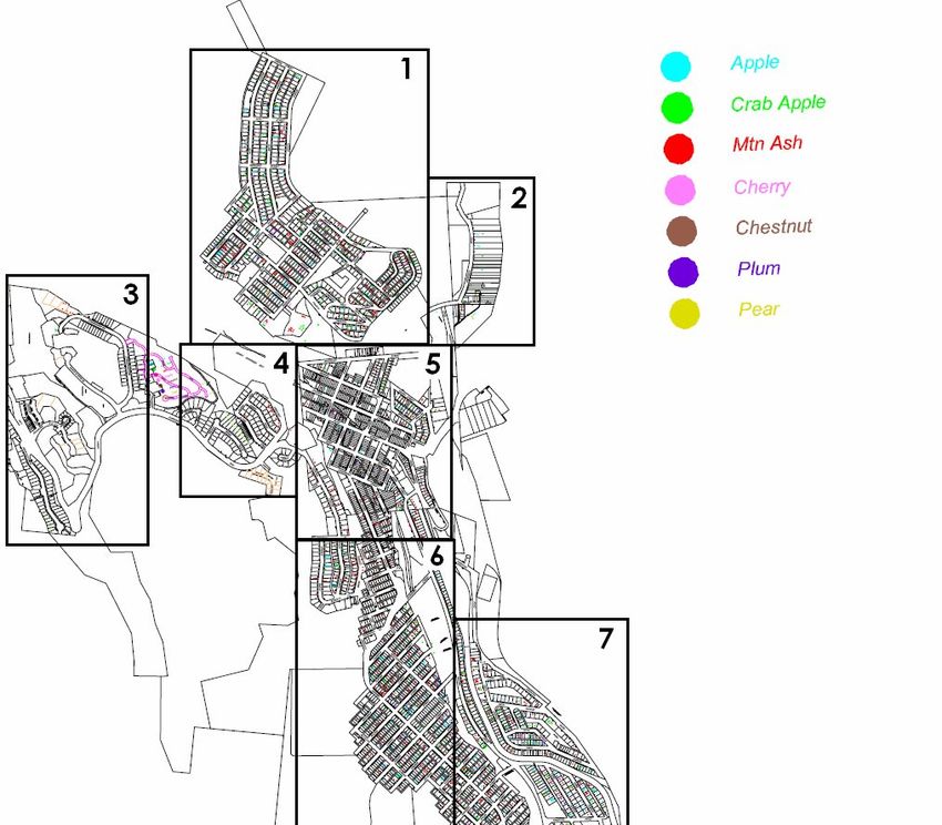
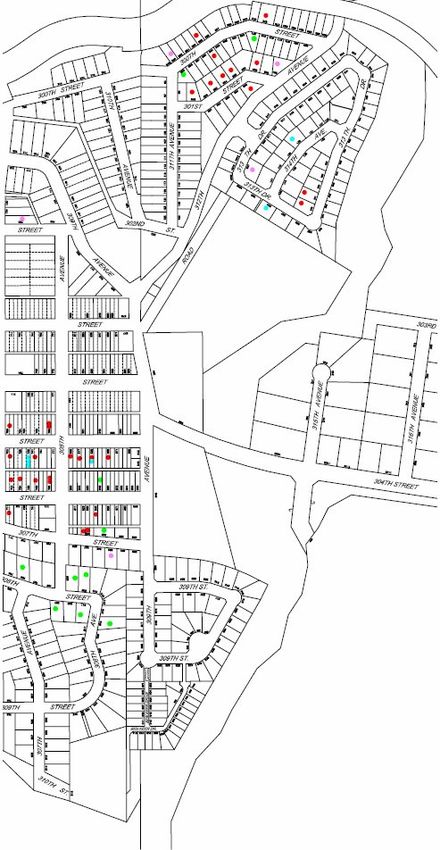
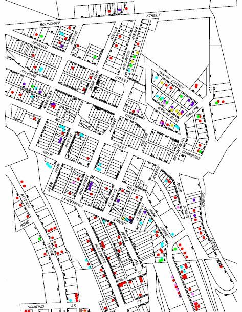
Fruit Tree Mapping
Table 15. Estimated number of fruit trees in Kimberley.
Bear Aware has identified the locations of various fruit trees in Kimberley. As
previously mentioned, fruit is a major bear attractant and many trees begin to produce fruit in
late-summer when bear activity begins to increase. Determining the relative densities of fruit
trees in Kimberley provides insight on where high levels of in-town bear activity may occur.
As displayed in Table 15, the most common form of fruit tree is the mountain ash. The
majority of problem bear incidents relating to fruit do not involve mountain ash trees; however,
mountain ash berries have been observed in bear scat and bears previously have been seen to
climb into mountain ash trees (such as in an incident occurring outside Fernie city hall in the fall
of 2006). Consequently, the current report recognizes that mountain ash berries may not be the
most powerful bear attractant of mapped fruits but should be included in the fruit tree map,
regardless.
Many of the fruit-related bear incidents reported or observed in 2007 involved crab apple
and apple trees. In the “Risk of Bear/Human Conflict in Various Areas of Kimberley” section,
potential for high in-town bear activity is associated with high densities of crab apple and apple
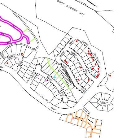
trees because of bears’ affinity for the trees’ fruit.Risk Assessment 43 Figure 13. Map of fruit tree densities in Kimberley. *Numerically labelled sections may be observed below* **The “Cherry” label in the legend refers to both cherry and choke cherry plants”
Risk Assessment 44

1
Risk Assessment 45

2
Risk Assessment 46

3
Risk Assessment 47

4
Risk Assessment 48

5
Risk Assessment 49

6
Risk Assessment 50

7
Risk Assessment 51

8
Risk Assessment 52

9
You can also read