King Buick Redevelopment - Comprehensive Transportation Study City of Rockville, MD
←
→
Page content transcription
If your browser does not render page correctly, please read the page content below
Comprehensive Transportation Study

King Buick Redevelopment
          City of Rockville, MD

    Second Submission - August 18, 2021
      First Submission - April 30, 2021
Prepared by:

1140 Connecticut Ave NW             3914 Centreville Road           15125 Washington Street              225 Reinekers Lane

          Suite 600                         Suite 330                         Suite 212                         Suite 750

 Washington, DC 20036                 Chantilly, VA 20171             Haymarket, VA 20169               Alexandria, VA 22314

      T 202.296.8625                    T 703.787.9595                    T 571.248.0992                    T 202.296.8625

                                                  www.goroveslade.com

This document, together with the concepts and designs presented herein, as an instrument of services, is intended for the specific
purpose and client for which it was prepared. Reuse of and improper reliance on this document without written authorization by
Gorove/Slade Associates, Inc., shall be without liability to Gorove/Slade Associates, Inc.
King Buick Site Redevelopment CTR                                                                                                                                                                            i

CONTENTS
Executive Summary ................................................................................................................................................................................... 1

   Proposed Project .................................................................................................................................................................................... 1

   Multi-Modal Overview ............................................................................................................................................................................. 1

   Site Impact and Mitigation Measures ..................................................................................................................................................... 2

   Summary and Recommendations .......................................................................................................................................................... 2

Introduction................................................................................................................................................................................................. 3

   Purpose of Study .................................................................................................................................................................................... 3

   Contents of Study ................................................................................................................................................................................... 3

Project Overview ........................................................................................................................................................................................ 7

   Site Land Use ......................................................................................................................................................................................... 7

   Site Access............................................................................................................................................................................................. 7

   Transit-Oriented Area (TOA) Designation .............................................................................................................................................. 7

   Trip Generation Summary ...................................................................................................................................................................... 7

Study Area and Multimodal Overview ...................................................................................................................................................... 11

   Study Intersections ............................................................................................................................................................................... 11

   Major Transportation Features ............................................................................................................................................................. 11

Existing Conditions ................................................................................................................................................................................... 15

   Land Parcel .......................................................................................................................................................................................... 15

   Existing Traffic Volumes ....................................................................................................................................................................... 15

   Existing Geometry and Operations ....................................................................................................................................................... 15

   Intersection Impact Thresholds and Capacity....................................................................................................................................... 16

   Existing Conditions Capacity Analysis .................................................................................................................................................. 16

   Existing Transit, Pedestrian, and Bicycle Facilities ............................................................................................................................... 24

Background Conditions ............................................................................................................................................................................ 31

   Background Developments .................................................................................................................................................................. 31

   Background Developments Trip Generation......................................................................................................................................... 31

   Background Regional Traffic Growth .................................................................................................................................................... 32

   Background Geometry and Operations Assumptions ........................................................................................................................... 32

   Background Conditions Capacity Analysis ........................................................................................................................................... 32

   Planned Transit and Bicycle Facilities .................................................................................................................................................. 41

Trip Generation and Trip Reduction ......................................................................................................................................................... 42

   Proposed Trip Generation .................................................................................................................................................................... 42

   Existing Trip Generation ....................................................................................................................................................................... 42

   Trip Reduction ...................................................................................................................................................................................... 42

August 18, 2021                                                                                                                                                                     goroveslade.com
King Buick Site Redevelopment CTR                                                                                                                                                                         ii

   Trip Generation Summary .................................................................................................................................................................... 42

Trip Distribution and Trip Assignment ...................................................................................................................................................... 43

Intersection Capacity Analysis for Total Future Conditions ...................................................................................................................... 48

   Future Geometry and Operations Assumptions ................................................................................................................................... 48

   Total Future Conditions Capacity Analysis ........................................................................................................................................... 48

Other Studies ........................................................................................................................................................................................... 53

   Signal Warrant Analysis ....................................................................................................................................................................... 53

   Queueing Analysis ............................................................................................................................................................................... 60

   Cut-Through Traffic Evaluation............................................................................................................................................................. 62

   Pedestrian Study .................................................................................................................................................................................. 63

Proposed On-Site Transportation ............................................................................................................................................................. 65

   Vehicular Access and Parking .............................................................................................................................................................. 65

   Pedestrian Access and Facilities .......................................................................................................................................................... 65

   Proposed Bicycle Access and Facilities ............................................................................................................................................... 65

Mitigation Requirements ........................................................................................................................................................................... 67

   Site Impact and Mitigation Requirements ............................................................................................................................................. 67

Summary and Conclusions....................................................................................................................................................................... 68

   Proposed Project .................................................................................................................................................................................. 68

   Multi-Modal Overview ........................................................................................................................................................................... 68

   Site Impact and Mitigation Measures ................................................................................................................................................... 69

   Summary and Recommendations ........................................................................................................................................................ 69

August 18, 2021                                                                                                                                                                  goroveslade.com
King Buick Site Redevelopment CTR                                                                                                                                                                        iii

LIST OF FIGURES
Figure 1: Site Location ............................................................................................................................................................................... 5
Figure 2: Site Aerial .................................................................................................................................................................................... 6
Figure 3: Site Plan ...................................................................................................................................................................................... 9
Figure 4: Transit-Oriented Area (TOA) Designation ................................................................................................................................. 10
Figure 5: Study Intersections Analyzed in CTR ........................................................................................................................................ 13
Figure 6: Project Location & Transportation Facilities .............................................................................................................................. 14
Figure 7: Unadjusted Existing Peak Hour Traffic Volumes ....................................................................................................................... 19
Figure 8: Adjustment Factor and Growth Rate Peak Hour Volume Adjustments...................................................................................... 20
Figure 9: Addition of Peak Hour Traffic Volumes for Network Volume Balancing..................................................................................... 21
Figure 10: Adjusted Existing Peak Hour Traffic Volumes ......................................................................................................................... 22
Figure 11: Existing Lane Configuration and Traffic Control ...................................................................................................................... 23
Figure 12: Existing Transit Facilities ......................................................................................................................................................... 26
Figure 13: Existing Pedestrian Facilities ................................................................................................................................................... 27
Figure 14: Existing Pedestrian Accommodations ..................................................................................................................................... 28
Figure 15: Streetlight Inventory ................................................................................................................................................................ 29
Figure 16: Existing and Future Bicycle Facilities ...................................................................................................................................... 30
Figure 17: Background Developments ..................................................................................................................................................... 35
Figure 18: Background Projects Peak Hour Traffic Volumes.................................................................................................................... 36
Figure 19: Background Growth Peak Hour Traffic Volumes ..................................................................................................................... 37
Figure 20: Removal of Existing Site Driveway Peak Hour Traffic Volumes .............................................................................................. 38
Figure 21: Approved Existing Site Trips Peak Hour Traffic Volumes ........................................................................................................ 39
Figure 22: Future without Development Peak Hour Traffic Volumes ........................................................................................................ 40
Figure 23: Inbound Distribution and Assignment ...................................................................................................................................... 44
Figure 24: Outbound Distribution and Assignment ................................................................................................................................... 45
Figure 25: Removal of Approved Site Trips Peak Hour Traffic Volumes .................................................................................................. 46
Figure 26: Site-Generated Peak Hour Traffic Volumes ............................................................................................................................ 47
Figure 27: Future Lane Configuration and Traffic Control ........................................................................................................................ 49
Figure 28: Future with Development Peak Hour Traffic Volumes ............................................................................................................. 50
Figure 29: Signal Warrant 2 Results (Weekday) ...................................................................................................................................... 56
Figure 30: Signal Warrant 2 Results (Saturday) ....................................................................................................................................... 56
Figure 31: Signal Warrant 3 Results (Weekday) ...................................................................................................................................... 57
Figure 32: Signal Warrant 3 Results (Saturday) ....................................................................................................................................... 57
Figure 33: Pedestrian Volumes Crossing MD 355 at King Farm Boulevard/Metro Station Access Road ................................................. 63
Figure 34: Pedestrian Volumes Crossing MD 355 at Ridgemont Avenue ................................................................................................ 63

August 18, 2021                                                                                                                                                                  goroveslade.com
King Buick Site Redevelopment CTR                                                                                                                                                                              iv

LIST OF TABLES
Table 1: King Buick Site Trip Generation Summary ................................................................................................................................... 8
Table 2: Summary of Study Area Roadways ............................................................................................................................................ 12
Table 3: Growth Rate Data and Applied Total Growth Rates ................................................................................................................... 15
Table 4: Intersection Impact Thresholds for Non-TOAs ........................................................................................................................... 16
Table 5: Intersection Impact Thresholds for TOAs ................................................................................................................................... 16
Table 6: Intersection Capacity .................................................................................................................................................................. 16
Table 7: Summary of Capacity Thresholds for Study Intersections .......................................................................................................... 17
Table 8: Summary of Existing Conditions Intersection Capacity Results ................................................................................................. 17
Table 9: Summary of Existing Conditions Intersection Capacity Results (HCM)*..................................................................................... 17
Table 10: Existing Conditions SimTraffic 50th and 95th Percentile Queueing Results for Study Intersections along Frederick Road (MD
355) .......................................................................................................................................................................................................... 18
Table 11: Local Bus Route Information .................................................................................................................................................... 24
Table 12: Bus Stop Inventory ................................................................................................................................................................... 24
Table 13: Sidewalk Requirements ............................................................................................................................................................ 25
Table 14: Pedestrian Crossing Distance Analysis Results ....................................................................................................................... 25
Table 15: Background Developments Trip Generation ............................................................................................................................. 33
Table 16: MDOT SHA Historical AADT Data ............................................................................................................................................ 33
Table 17: Growth Rate Data and Applied Annual and Total Growth Rates .............................................................................................. 33
Table 18: Summary of Background Conditions Intersection Capacity Results ......................................................................................... 33
Table 19: Summary of Background Conditions Intersection Capacity Results (HCM)* ............................................................................ 33
Table 20: B Background Conditions SimTraffic 50th and 95th Percentile Queueing Results for Study Intersections along Frederick Road
(MD 355) .................................................................................................................................................................................................. 34
Table 21: Trip Generation Summary ........................................................................................................................................................ 42
Table 22: Summary of Total Future Conditions Intersection Capacity Results ......................................................................................... 51
Table 23: Summary of Total Future Conditions Intersection Capacity Results (HCM)* ............................................................................ 51
Table 24: Total Future Conditions SimTraffic 50th and 95th Percentile Queueing Results for Study Intersections along Frederick Road
(MD 355) .................................................................................................................................................................................................. 52
Table 25: MdMUTCD Table 4C-1 Warrant 1, Eight-Hour Vehicular Volumes .......................................................................................... 53
Table 26: Total Future Traffic Volumes and Signal Warrant 1 Results (Weekday) ................................................................................... 54
Table 27: Total Future Traffic Volumes and Signal Warrant 1 Results (Saturday) ................................................................................... 54
Table 28: 95th Percentile Queue and Delay Results for the Main Site Driveway Intersection without and with Proposed Signalization... 60
Table 29: SimTraffic 50th and 95th Percentile Queueing Results for Study Intersections along Frederick Road (MD 355) with Proposed
Signalization of Site Driveway .................................................................................................................................................................. 61

August 18, 2021                                                                                                                                                                        goroveslade.com
King Buick Site Redevelopment CTR                                                                                                       1

Executive Summary
The following report is a Comprehensive Transportation Review        County, Maryland Department of Transportation State Highway
(CTR) for the King Buick site redevelopment. This report reviews     Administration (SHA), and Americans with Disabilities Act (ADA)
the transportation aspects of the project’s Preliminary Plan         standards for sidewalks, crosswalks, and curb ramps. This
application in compliance with City of Rockville’s Comprehensive     includes sidewalks that meet or exceed the width requirements,
Transportation Review (CTR) guidelines.                              crosswalks at all necessary locations, and curb ramps with
                                                                     detectable warnings. Existing pedestrian facilities connect the
The purpose of this study is to evaluate whether the project will
                                                                     site to Frederick Road and will connect the project to the Shady
generate a detrimental impact to the surrounding transportation
                                                                     Grove Metrorail station to the northeast, encouraging non-auto
network. This evaluation is based on a technical comparison of
                                                                     travel.
the existing conditions, background conditions, and total future
conditions. The following conclusions were reached based on          Access to the existing car dealership is provided along Frederick
this technical analysis:                                             Road through two (2) curb cuts. Two (2) additional curb cuts
                                                                     along the frontage of the site are not active and are currently
    •    All of the study intersections identified by City for
                                                                     used as space to showcase cars. The existing full-access
         evaluation will operate within acceptable levels after
                                                                     driveway at the median break will be improved to serve as the
         considering existing volumes, background
                                                                     primary access to the project. The three (3) other existing curb
         developments, background growth and site-generated
                                                                     cuts along Frederick Road will be removed. A second access to
         traffic (total future conditions) without the need for
                                                                     the development is proposed to the southwest of the site to
         mitigation measures; and,
                                                                     provide a connection to Pleasant Drive.
    •    A signal warrant analysis at the full-access site
         driveway at Fredrick Road determined that future            Multi-Modal Overview
         conditions at this intersection meet the four-hour signal   Transit
         warrant and the peak-hour signal warrant with the           The site is adequately served by regional and local transit
         projected traffic volumes from the proposed project.        services such as Metrorail, MARC, and Ride On-Montgomery
This report concludes that the project will not have a               County. The site is approximately 0.7 miles from the Shady
detrimental impact to the surrounding transportation network         Grove Metrorail station. The nearest Ride On stop is located
assuming that all proposed site design elements are                  approximately 0.1 miles south of the site on Frederick Road.
implemented.                                                         Three (3) Ride On-Montgomery County routes directly service
                                                                     the site, providing a good connection to Metrorail and other
Proposed Project                                                     destinations. Additional Ride On stops are located along Shady
The site, located at 16200 Frederick Road, is currently occupied     Grove Road approximately 0.2 miles from the site.
by the King Buick/GMC/Mitsubishi car dealership. The site is
                                                                     Pedestrian
generally bounded by Frederick Road (MD 355) to the east,
commercial uses to the north, and the King Farm residential          The site is surrounded by a pedestrian network providing good
community to the south and west. The property currently              connectivity to nearby points of interests. Most roadways within a
straddles the City of Rockville and Montgomery County while the      quarter-mile radius provide sidewalks and acceptable crosswalks
property is in the process of being annexed into the City of         and curb ramps, particularly along primary walking routes.
Rockville from Montgomery County.                                    As a result of the development, pedestrian facilities along the
The project will replace the car dealership site and the existing    perimeter of the site will be improved. The development will
vacant grass area with a residential subdivision, consisting of      install a shared-use path along the site frontage on the
368 townhomes and an approximately 5,000 square feet                 southbound side of Frederick Road. The site will be served by a
community center.                                                    new internal sidewalk network. These sidewalks will provide
                                                                     extensive pedestrian connections within the development. The
Pedestrian facilities along the perimeter of the site on Frederick
                                                                     proposed internal sidewalk network will also connect the site with
Road will be improved and designed so that they meet or exceed

August 18, 2021                                                                                                       goroveslade.com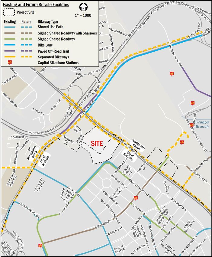
King Buick Site Redevelopment CTR                                                                                                        2

Pleasant Drive, providing inter-community connections for              Summary and Recommendations
pedestrians. The proposed sidewalks will meet or exceed SHA            This report concludes that the proposed development will not
and ADA requirements and provide an improved pedestrian                have a detrimental impact to the surrounding transportation
environment.                                                           network assuming that all planned site design elements are
                                                                       implemented. The full-access site driveway and Fredrick Road
Bicycle
                                                                       intersection meets the four-hour signal warrant and the peak-
The site has access to existing bicycle facilities. There are
                                                                       hour signal warrant with the projected traffic volumes from the
existing shared use paths along Gaither Road and Piccard Drive
                                                                       proposed project. Signalizing the site driveway and Frederick
to the south and west of the site, and existing shared roadway
                                                                       Road (MD 355) intersection will reduce the delay for inbound and
routes along King Farm Boulevard and Grand Champion Drive to
                                                                       outbound site trips and provide an additional connection for
the south and east of the site. According to the Montgomery
                                                                       pedestrians to the Shady Grove Metro station.
County Bicycle Master plan, separated bikeway routes are
recommended along the site frontage on Frederick Road and              The development has several positive elements contained within
along Shady Grove Road to the north of the site. The separated         its design that minimize potential transportation impacts,
bikeways allow shared use between bicyclists and pedestrians,          including:
providing connectivity to the cores of City of Rockville and City of
                                                                         •    The site’s proximity to the Metrorail Red Line, MARC
Gaithersburg.                                                                 Train Brunswick Line, and several local and regional bus
                                                                              lines;
Vehicular
The site is directly served by Frederick Road (MD 355) and is in         •    The site’s location within a well-connected pedestrian
                                                                              network; and
close proximity to Shady Grove Road, both principal arterials
providing a robust network of local and regional connectivity.           •    The pedestrian and bicycle facilities adjacent to and within
These roadways connect the site to the nearby I-370 and I-270,                the site being that will be improved as part of the project.
which provide access to the Intercounty Connector (MD 200) and
the Capital Beltway (I‐495).

Site Impact and Mitigation Measures
In order to determine if the proposed development will have a
negative impact on this transportation network, this report
projects future conditions with and without the development of
the site and performs intersection capacity analyses using the
Critical Lane Volume (CLV) technique. The intersection
volume/capacity (v/c) ratios and the corresponding Level of
Service (LOS) are compared to the intersection impact
thresholds for transit-oriented areas (TOAs) and non-transit-
oriented areas (non-TOAs) set by City of Rockville CTR
standards to determine if the site will negatively impact the study
area. Signalized intersections that operate at or near capacity
under existing conditions were further analyzed using the
Highway Capacity Manual (HCM) methodology.

A signal warrant analysis was conducted for the intersection of
Frederick Road (MD 355) and the full-access site driveway. The
analyses conclude that this intersection meets Warrant 2: Four-
Hour Vehicular Volume and Warrant 3: Peak Hour signal
warrants in future conditions with the development.

August 18, 2021                                                                                                         goroveslade.com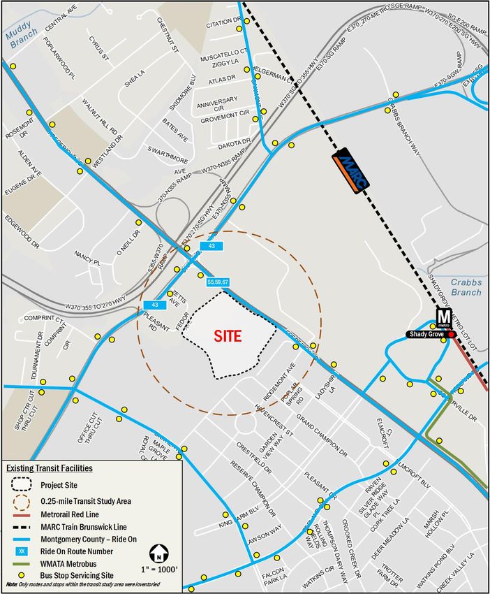
King Buick Site Redevelopment CTR                                                                                                        3

Introduction
This report reviews the transportation elements of the King Buick           overview of the multimodal facilities around the
site redevelopment. The site, shown in Figure 1, currently                  transportation study area.
straddles the City of Rockville and Montgomery County while in
                                                                        •   Existing Conditions
the process of being annexed into the City of Rockville from
                                                                            This component reviews the existing conditions within the
Montgomery County. Figure 2 provides an aerial of the site.
                                                                            transportation study area, including the roadway network,
Purpose of Study                                                            existing peak-hour traffic volumes, and existing capacity
                                                                            analyses. This component also summarizes the existing
The purpose of this report is to:
                                                                            pedestrian, bicycle, and transit access and facilities
  1.     Review the transportation elements of the development
                                                                            around the site.
         site plan and demonstrate that the site conforms to the
         City of Rockville’s CTR policies.                              •   Background Conditions
  2.     Provide information to the City of Rockville, MCDOT,               This component outlines the background traffic
         MDOT SHA, and other agencies on how the                            components, including approved pipeline developments
         development of the site will influence the local                   and annual traffic growth, and performs capacity analyses
         transportation network. This report accomplishes this by           for background conditions. This component also reviews
         identifying the potential trips generated by the site on all       planned roadway, pedestrian, bicycle, and transit
         major modes of travel and where these trips will be                improvements by other agencies around the site.
         distributed on the network.
                                                                        •   Trip Generation and Trip Reduction
  3.     Determine whether the proposed project will lead to an
                                                                            This component outlines the travel demand of the
         adverse impact on the local transportation network.
                                                                            proposed project. It summarizes the proposed trip
         This report accomplishes this by projecting future
                                                                            generation of the project and outlines the applicable trip
         conditions with and without development of the site and
                                                                            reduction factors for the site trip generation.
         performing analyses of study area intersections using
         the CLV methodology as required by the CTR                     •   Trip Distribution and Trip Assignment
         guidelines. Intersection v/c ratios and the corresponding          This component provides the assumptions of the trip
         LOS are compared to the impact thresholds set by City              distribution and route assignment for the site-generated
         of Rockville CTR standards to determine if the site will           trips.
         negatively impact the study area. The report discusses         •   Intersection Capacity Analysis
         what improvements to the transportation network are                This component summarizes the intersection capacity
         needed to mitigate adverse impacts as needed.                      analysis results of the total future conditions.

Contents of Study                                                       •   Other Studies
This report contains 11 components as follows:                              This component includes other requested traffic studies,
                                                                            including a traffic signal warrant study, a queueing
  •    Project Overview
                                                                            analysis, a cut-through traffic evaluation, and a pedestrian
       This component reviews the area near and adjacent to
                                                                            study.
       the proposed project and includes an overview of the
       project, including existing and proposed land uses, site         •   Proposed On-Site Transportation
       plan and access, transit-oriented area (TOA) designation,            This component reviews the transportation aspects of the
       and a summary of the site trip generation before                     project, including site access, vehicle parking, bicycle
       reductions and/or credits.                                           parking, pedestrian facilities, and bicycle facilities
                                                                            proposed by the project.
  •    Study Area and Multimodal Overview
       This component includes the transportation study area            •   Mitigation Requirements
       and study intersections of the project and provides an               This component reviews the mitigation requirements that

August 18, 2021                                                                                                         goroveslade.com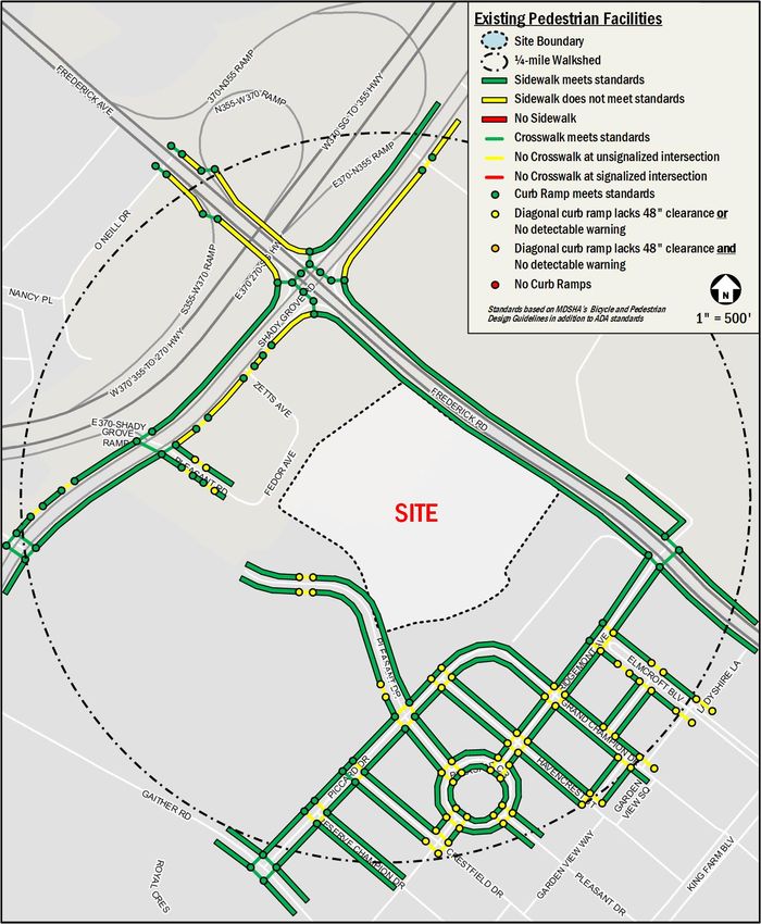
King Buick Site Redevelopment CTR                                             4

      apply to the development and discusses any proposed
      mitigation measures, as necessary.

  •   Summary and Conclusions
      This component presents overall findings and conclusions
      and presents a summary of the recommended mitigation
      measures by mode, as necessary.

August 18, 2021                                                  goroveslade.com
King Buick Site Redevelopment CTR 5
Figure 1: Site Location
August 18, 2021 goroveslade.comKing Buick Site Redevelopment CTR 6
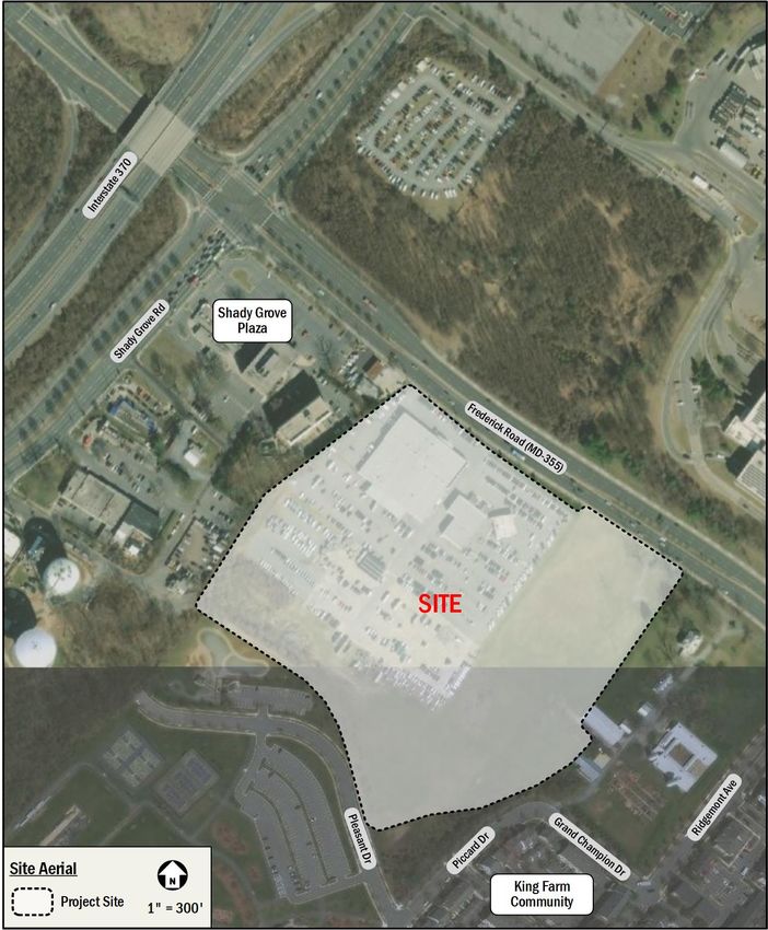
Figure 2: Site Aerial
August 18, 2021 goroveslade.comKing Buick Site Redevelopment CTR 7
Project Overview
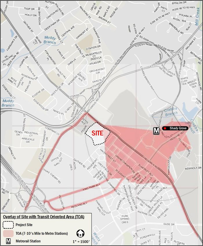
This section provides an overview of the development project, Transit-Oriented Area (TOA) Designation
including the existing and proposed land uses of the site, transit-
Figure 4 shows the site location with an overlay of the transit-
oriented area (TOA) designation of the project site, and a
oriented area (TOA) defined in Appendix C of the City of
summary of the trip generation before any reductions or credits.
Rockville CTR guidelines. Although only a portion of the site is
Site Land Use located within the defined TOA, TOA-specific considerations are
applicable to the project due to its proximity and accessibility to
Existing Land Use
the Shady Grove Metrorail station, as approved by City Staff
The site, located at 16200 Frederick Road, is generally bounded during the scoping process.
by Frederick Road (MD 355) to the northeast, commercial uses
to the northwest, and the King Farm residential community to the Trip Generation Summary
south and west. The property currently straddles the City of Trip generation for the proposed redevelopment was based on
Rockville and Montgomery County and is in the process of being the methodology outlined in the Institute of Transportation
annexed to the City of Rockville from Montgomery County. Engineers (ITE) Trip Generation Manual, 10th Edition and the
City of Rockville Comprehensive Transportation Review (CTR)
The existing land use is retail consisting of approximately 56,540
guidelines (2018).
square feet dedicated to new-car dealership use, and
approximately 3,600 square feet dedicated to used-car Trip generation rates for “Automobile Sales (New)”, ITE Land
dealership use. The site also includes a paved parking lot utilized Use 840, were used in trip generation calculations for all the
by the car dealership. There is also a significant portion of existing dealership uses, following the ITE Land Use 840
unutilized grass area within the southeast and southwest description that automobile sales (new) may include the sale or
portions of the site. leasing of new cars, used car sales, automobile service, and
parts sales.
Proposed Land Use
The project will replace the existing buildings, parking lot, and Trip generation rates for “Residential (Low-Rise)” (Land Use
grass area with a residential subdivision, consisting of 368 220) were used in trip generation calculations for the residential
townhomes and an approximately 5,000 square feet community subdivision. The proposed community center is for residents’ use
center. only and is not expected to generate external trips to the site.
Because of the TOA designation of the site, a trip reduction of 15
Figure 3 shows an overview of the development program and
percent was applied to account for non-auto mode splits.
site plan elements.
The total site-generated vehicular trip results with credits and
Site Access reductions are summarized in Table 1.
Access to the existing car dealership uses two (2) curb cuts on As shown in Table 1, the trip generation for the development
Frederick Road. Two (2) additional curb cuts along the frontage program will generate 27 net new trips in the morning peak hour
of the site are not active and are currently used as space to (50 fewer inbound trips, 77 new outbound trips), 14 net new trips
showcase cars. The existing full-access driveway at the median in the afternoon peak hour (42 new inbound trips, 28 fewer
break will be improved to serve as the primary access to the outbound trips), and 67 net new trips in the Saturday peak hour
residential subdivision. The three (3) other existing curb cuts (46 new inbound trips, 21 new outbound trips).
along Frederick Road will be removed. A second driveway is
proposed to the southwest of the site to provide a connection to The City of Rockville CTR guidelines require vehicular analysis if
Pleasant Drive. The layout of the site access is shown in Figure a development generates 30 or more trips. As seen in Table 1,
3. the development will generate more than 30 peak-hour vehicle
trips. As such, a vehicular capacity analysis will be required for
the proposed development.
August 18, 2021 goroveslade.comKing Buick Site Redevelopment CTR 8
Table 1: King Buick Site Trip Generation Summary
AM Peak Hour PM Peak Hour Sat Peak Hour
Land Use Size ADT
In Out Total In Out Total In Out Total
Existing Trip Generation
Auto Sales New (840) 60,140 sf ITE 82 30 112 58 88 146 1,694 121 121 242
Total Existing Trips 82 30 112 58 88 146 1,694 121 121 242
Proposed Trip Generation
Residential (220) 368 units ITE 38 126 164 118 70 188 2,741 197 167 364
Subtotal Proposed Trips 38 126 164 118 70 188 2,741 197 167 364
Multimodal trip reduction (15% for TOA) -6 -19 -25 -18 -10 -28 -411 -30 -25 -55
Total Site trips with Reduction 32 107 139 100 60 160 2,330 167 142 309
Net New Trips without 15% TOA Reduction* -44 96 52 60 -18 42 1,047 76 46 122
Net New Trips with 15% TOA Reduction** -50 77 27 42 -28 14 636 46 21 67
* Used to determine study area and mitigation requirements.
** Used in the capacity analysis.
August 18, 2021 goroveslade.comKing Buick Site Redevelopment CTR 9
Figure 3: Site Plan
August 18, 2021 goroveslade.comKing Buick Site Redevelopment CTR 10
Figure 4: Transit-Oriented Area (TOA) Designation
August 18, 2021 goroveslade.comKing Buick Site Redevelopment CTR 11
Study Area and Multimodal Overview
This section specifies the transportation study area of this project Major Transportation Features
and includes a summary of the major multimodal transportation
Overview of Regional Access
characteristics of the study area.
The site has ample access to regional, vehicular, and transit-
This section concludes:
based transportation options, shown in Figure 6, that connect the
• Six (6) significant intersections within 0.25 miles of the site site to destinations within Maryland, Virginia, and the District.
are included in the study area for analysis.
The site has direct frontage on Frederick Road (MD 355) and is
• The site is surrounded by an extensive regional and local in close proximity to Shady Grove Road. Both principal arterials
transportation system that will connect the proposed that connect the site to I-270, I-370, the Intercounty Connector
project’s residents and employees to the rest of the (MD 200), and the Capital Beltway (I‐495), providing ample
surrounding areas.
connectivity to the Washington DC Metropolitan area and its
• The site is well-served by public transportation, being in inner suburbs, as well as regional destinations in Maryland and
proximity to the Shady Grove Metrorail station and several Virginia.
local and regional bus lines.
The site is located approximately 0.7 miles, approximately a 15-
• There is existing bicycle infrastructure surrounding the site
minute walk, from the Shady Grove Metrorail station, which is
including shared use paths to the south and west of the
served by the Red Line. The Red Line runs from the Shady
site, which provide north-south connectivity to the site.
Grove station in Rockville, through DC, to Glenmont in Silver
• Pedestrian conditions are generally good, particularly Spring, making the rest of the Metrorail lines and most of the DC
along anticipated major walking routes.
Metropolitan area accessible via public transportation. The site
Study Intersections also has access to the Brunswick Line of the MARC rail system
at the Washington Grove station, which provides connections to
The City of Rockville CTR guidelines specify the minimum
areas in the District, Maryland, and West Virginia.
number of intersections to be analyzed and the minimum radius
of the transportation study area based on the new peak hour site Overall, the site has excellent access to regional roadways and
trips before reductions are applied. transit options, making it convenient to travel between the site
and destinations in Maryland, Virginia, and the District.
As shown in Table 1, the net new morning and afternoon peak
hour trips with credit given for the existing land use are greater Overview of Local Access
than 30 and fewer than 124. Per the CTR guidelines, at least
There are local transportation options near the site that serve
four (4) significant intersections within 0.25 miles of the site are
vehicular, transit, walking, and bicycling trips.
required to be analyzed. Per the scoping agreement letter
approved by the City and included in the Technical Attachments, The site is served by a local vehicular network that includes
the following intersections, shown in Figure 5, were chosen for principal arterials such as Frederick Road (MD 355) and Shady
analysis: Grove Road. In addition, there is an existing network of collector
and local roadways that provide direct access to the site. Table 2
1. Frederick Road (MD 355) & Shady Grove Road
provides a list of the local roadways in the project study area.
2. Frederick Road (MD 355) & Full-Access Site Driveway
3. Frederick Road (MD 355) & Right-In / Right-Out Site The Ride On-Montgomery County bus system provides local
Driveway (Existing and Background Conditions only) transit service in the vicinity of the site. There are three (3) bus
4. Frederick Road (MD 355) & Ridgemont Avenue routes that service the site directly, traveling along Frederick
5. Piccard Drive & Pleasant Drive Road. There is one (1) additional bus route traveling along
6. Park Road (northern extension of Pleasant Drive) &
Shady Grove Road. Four (4) other Ride On-Montgomery County
Rear Site Driveway
bus routes and four (4) WMATA Metrobus routes serve the west
side of Shady Grove Metrorail station.
August 18, 2021 goroveslade.comKing Buick Site Redevelopment CTR 12
There are existing shared use paths along Gaither Road and In the vicinity of the site, most roadways provide sidewalks with
Piccard Drive to the south and west of the site, and existing crosswalks present at most intersections. Anticipated pedestrian
shared roadway routes along King Farm Boulevard and Grand routes, such as those to public transportation stops, retail zones,
Champion Drive to the south and east of the site. As part of the and community amenities, provide good pedestrian facilities. A
2018 Montgomery County Bicycle Master plan, separated detailed review of existing pedestrian access and infrastructure
bikeway routes are recommended along the site frontage on is provided in the Existing Conditions section of this report.
Frederick Road and along Shady Grove Road to the north of the
Overall, the site is surrounded by a local transportation network
site, filling in missing gaps and improving connectivity for
that allows for convenient transportation options via transit,
bicycles to and from the site.
bicycle, walking, or vehicular modes.
Table 2: Summary of Study Area Roadways
Functional
Roadway Jurisdiction Rural vs Urban # of Lanes Speed Limit
Classification
Frederick Road (MD 355) Maryland SHA Principal Arterial Urban 6 40 MPH
Shady Grove Road Montgomery County Principal Arterial Urban 6 40 MPH
Ridgemont Avenue City of Rockville Local Urban 2 25 MPH
King Farm Boulevard City of Rockville Local Urban 2 25 MPH
Pleasant Drive City of Rockville Local Urban 2 25 MPH
August 18, 2021 goroveslade.comKing Buick Site Redevelopment CTR 13
Figure 5: Study Intersections Analyzed in CTR
August 18, 2021 goroveslade.comKing Buick Site Redevelopment CTR 14
Figure 6: Project Location & Transportation Facilities
August 18, 2021 goroveslade.comKing Buick Site Redevelopment CTR 15
Existing Conditions
This section provides a summary of an analysis of the existing the afternoon peak hour volumes captured before 4:30 PM. For
roadway capacity in the study area. The capacity analysis all intersections, the individual intersection peak hours were
focuses on the morning and afternoon commuter peak hours as used. The results of the raw traffic counts are included in the
determined by the existing traffic volumes in the study area. This Technical Attachments.
section also outlines the existing conditions of transit, pedestrian,
Historical traffic volumes from MCDOT’s Intersection Analysis
and bicycle facilities in the vicinity of the site.
online application are available at the remaining two (2) study
Land Parcel intersections:
The site, located at 16200 Frederick Road, is generally bounded • Frederick Road (MD 355) & Shady Grove Road, collected
by Frederick Road (MD 355) to the northeast, commercial uses Wednesday, October 3, 2018
to the northwest, and the King Farm residential community to the • Frederick Road (MD 355) & Ridgemont Avenue, collected
south and west. Thursday, September 27, 2018
The existing site is improved with retail uses consisting of Per M-NCPPC’s policy on historical counts, growth rates based
approximately 56,540 square feet dedicated to a new-car on MDOT SHA AADT data, included in the Technical
dealership and approximately 3,600 square feet dedicated to Attachments, were applied to the 2018 volumes. Table 3 outlines
used-car sales. the applied growth rates.
The site is directly served by a principal arterial, Frederick Road Table 3: Growth Rate Data and Applied Total Growth Rates
(MD 355). In addition, there is an existing network of other MDOT SHA AADT Assumed
Average Annual Total Growth
arterials and local roadways that provide access to the site, such Road
Growth Between Between 2018
as Shady Grove Road. 2010-2019 and 2020
Frederick Road
0.61% 1.20%
Figure 1 provides an overview of the site location and Table 2 (MD 355)
provides a list of the local roadways in the project study area, as Shady Grove Road
-0.09% 0.20%
West of MD 355
described in previous sections of this report. Shady Grove Road
-3.74% 0.20%
East of MD 355
Existing Traffic Volumes Ridgemont Avenue N/A 0.20%
Due to the COVID-19 pandemic, M-NCPPC issued guidance on In addition, some volumes were added along the Frederick Road
alternative approaches to establish existing baseline traffic (MD 355) corridor to achieve a balance between the study
volumes. This analysis applies an adjustment factor to counts intersections based on the 2018 count data, representing pre-
collected in 2020, consistent with the latest policy pertaining to COVID-19 traffic patterns.
traffic counts outlined in the Traffic Counts During COVID-19
Figure 7 shows the raw unadjusted peak hour volumes at the
Pandemic – Policy Update memorandum dated September 17,
study intersections. Figure 8 shows the adjustment volumes
2020, included in the Technical Attachments.
based on the adjustment factor and growth. Figure 9 shows the
Turning movement count data was collected at three (3) out of addition of volumes to balance the study intersections after the
the five (5) study intersections on Wednesday, December 2, application of adjustment factors and growth rates. Figure 10
2020, including the following: shows the existing peak hour volumes after adjustments.
• Frederick Road (MD 355) & Existing Full-Access Site
Existing Geometry and Operations
Driveway
Field observations and MCDOT data confirmed the existing lane
• Frederick Road (MD 355) & Existing Right-In-Right-Out
configurations and traffic controls at the study intersections.
Site Driveway
Existing signal timings and offsets were obtained from MCDOT.
• Piccard Drive and Pleasant Drive
Per M-NCPPC’s policy on the new traffic counts, an adjustment
factor of 1.07 was applied to the morning peak hour volumes and
August 18, 2021 goroveslade.comKing Buick Site Redevelopment CTR 16
The lane configurations and traffic controls for the existing Table 7 summarizes the thresholds for volume to capacity ratio
conditions are shown in Figure 11. Signal timing data provided (v/c) and the corresponding LOS for each study intersection,
by MCDOT are included in the Technical Attachments. based on their TOA designation, roadway classification, traffic
control, signal phase, and cycle length.
Intersection Impact Thresholds and Capacity
The City’s CTR guidelines outline the intersection impact Existing Conditions Capacity Analysis
thresholds based on different road classification for intersections Intersection capacity analyses were performed at the study
located outside a TOA or along TOA access roadways, as intersections shown in Figure 5 for the morning and afternoon
shown in Table 4 and Table 5 respectively. peak hours. The critical lane volume (CLV) method was used to
analyze the study intersections based on methodology outlined
Table 4: Intersection Impact Thresholds for Non-TOAs
Threshold in Appendix E of the City’s CTR guidelines. Table 8 summarizes
Corresponding
Road Classification* for Volume the capacity analysis results for existing conditions. Detailed CLV
LOS
/Capacity
Primary Residential – Class II analyses are provided in the Technical Attachments.
(Minor Collector), Secondary 0.79 C
Residential It was found that under existing conditions, all study intersections
Major Arterials (Except where two operate within the acceptable capacity thresholds during both the
Major Arterials connect), Minor morning and afternoon peak hours, with the exception of the
Arterials, Primary Residential – 0.89 D
Class I (Major Collector), Primary Frederick Road (MD 355) and Shady Grove Road intersection
Industrial, Secondary Industrial
which operates near the capacity threshold during the morning
Business District roads, freeway peak hour.
ramps, and for locations where 0.99 E
two Major Arterials intersect
A supplemental analysis was requested by City of Rockville and
*At intersections where two or more roads with different road classifications
meet, the LOS threshold will be established based on the higher roadway MDOT SHA., Signalized intersections along the Frederick Road
classification (the classification where more congestion is acceptable). (MD 355) corridor were analyzed using the Highway Capacity
Table 5: Intersection Impact Thresholds for TOAs Manual (HCM) methodology in addition to the required CLV
Threshold analyses. Synchro Version 10 was used to analyze the
Corresponding
Road Classification* for Volume
LOS signalized study intersections of Frederick Road (MD 355)/Shady
/Capacity
Primary Residential – Class II Grove Road and Frederick Road (MD 355)/Ridgemont Avenue.
(Minor Collector), Secondary 0.89 D
Residential Table 9 shows the results of the HCM capacity analysis,
Major Arterials, Minor Arterials,
including LOS and average delay per vehicle (in seconds), at
Primary Residential – Class I these intersections. The HCM analysis results were generally
(Major Collector), Primary 0.99 E
Industrial, Business District and consistent with the CLV analysis results. Using the HCM
Secondary Industrial methodology, the Frederick Road (MD 355) and Shady Grove
*At intersections where two or more roads with different road classifications
intersection operates at an unacceptable level of service (LOS)
meet, the LOS threshold will be established based on the higher roadway
classification (the classification where more congestion is acceptable). during the afternoon peak hour.
Intersection capacity for each of the study intersections is SimTraffic microsimulation was performed for the queueing
calculated using Table 6 from the City’s CTR guidelines. For analysis along the Frederick Road (MD 355) corridor. Table 10
unsignalized intersections, a 90-second cycle length and 2- shows the queueing analysis results for the study intersections
phase operation was assumed, based on the City’s CTR along the Frederick Road (MD 355) corridor.
guidelines.
Table 6: Intersection Capacity
Cycle Length Number of Phases
(seconds) 2 3 4 or more
89 or less 1500 1400 1300
90 - 119 1600 1500 1400
120 - 149 1650 1600 1500
150 or more 1700 1650 1550
August 18, 2021 goroveslade.comYou can also read