Koninklijk Museum voor Midden-Afrika Verslagen van het departement Aardwetenschappen Musée royal de l'Afrique centrale Rapports du département des ...
←
→
Page content transcription
If your browser does not render page correctly, please read the page content below
Koninklijk Museum voor Midden-Afrika
Verslagen van het departement Aardwetenschappen

         Musée royal de l’Afrique centrale
 Rapports du département des Sciences de la Terre

         Royal Museum for Central Africa
     Reports of the Earth Sciences department

                       2017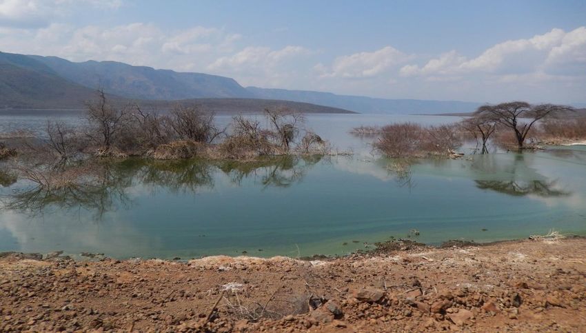
Surface environments and collection
management
Évolution du personnel
Gijs De Cort, PhD scientist , left the service on December 2017

Projets : de recherche, expositions, activités éducatives, de
communication

                           Projet 1 : Projet « focus » « Pamexea »
   Nom (et acronyme)          Patterns and mechanisms of climate extremes in East Africa (PAMEXEA)
                              Source : Belspo (Brain)
       Financement
                              Budget : 997.000 euros

                              Responsable interne : Florias MEES

                              Collaborateurs internes : Gijs De Cort
       Partenaires
                              Collaborateurs externes : UGent, UCL, Royal Botanical Garden (Meise),
                              University of Twente, Hydrological Research Center (San Diego)
       URL site web
                              Début : 2013
          Dates
                              Fin : 2017

                              Main components : (i) palaeohydrological reconstruction for specific rift
                              valley lakes to document climate variability during the last 2000 years; (ii)
                              compilation of climate-proxy data for East Africa for the same period, to
 Description générale du
                              produce a spatially-resolved history of past East African climate change;
          projet
                              and (iii) evaluation and refinement of climate models, ultimately to
                              similate future climate trends and variability under specific combinations
                              of natural and anthropogenic factors.
                              Analysis of sediment cores from Lake Bogoria and Nasikie Engida (Kenya).
Évolution et résultats pour
     l’année écoulée

                                  Projet 2 : Projet « Si-PALEO »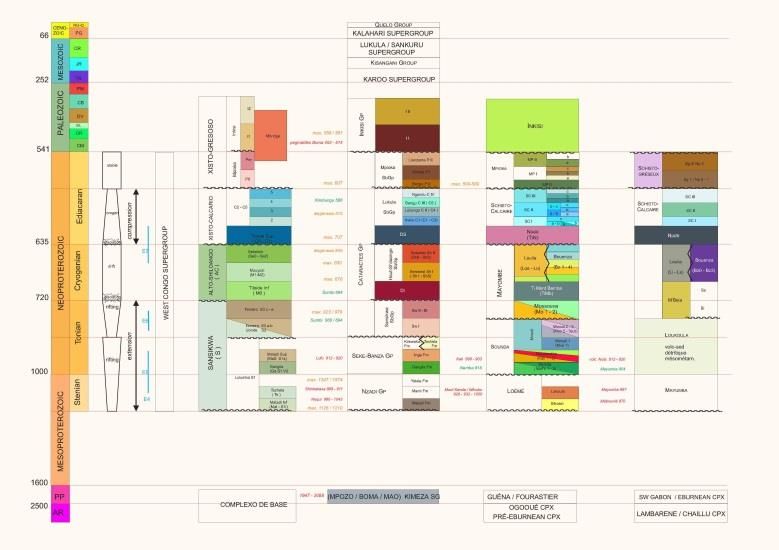
Establishing Silicon Isotopes as Weathering Tracers for
   Nom (et acronyme)
                              Paleoenvironmental Studies (SI-PALEO)
                              Source : Marie Curie IEF Fellowship EU
      Financement
                              Budget : 235000€

                              Responsable interne : Luc André

                              Collaborateurs internes : Laurence Monin,
       Partenaires
                              Collaborateurs externes : S. Bouillon (KU Leuven), A. Borges (Univ. Liège),
                              E. Schefuss, L. Dupont (Univ. Bremen), A. laraque (IRD Montpellier)

      URL site web
                              Projet terminé en ce qui concerne les analyses mais continuant en 2017 et
                              2018 par la rédaction des publications
          Dates

                              Les principaux objectifs du projet SI-PALEO étaient 1) de déterminer les
                              facteurs contrôlant la distribution des isotopes du silicium (Si) dans les
 Description générale du
                              sédiments marins, et 2) d’évaluer l’impact des changements climatiques et
          projet
                              des activités humaines sur l’altération des roches silicatées en Afrique
                              centrale au cours des derniers milliers d’années.
                              Les résultats fort originaux font l’objet de publication dans des revues de
Évolution et résultats pour   fort facteur d’impact. La première publication a été soumise en décembre
     l’année écoulée          2017 à la revue Geochimica et Cosmochimica acta.

                              Projet 3 : Si isotopes in Great Lakes
   Nom (et acronyme)          Establishing Silicon Isotopes as a proxy of Lake dynamic
                              Source : MRAC)
      Financement
                              Budget : dotation

                              Responsable interne : Luc André

       Partenaires            Collaborateurs internes : Laurence Monin

                              Collaborateurs externes :
      URL site web
                              Début :2013
          Dates
                              Fin :2018
Stable Silicon (Si) isotopes (28Si, 29Si, and 30Si) studies offer an efficient
proxy for investigating the complex abiotic and biotic controls on
continental Dissolved Si fluxes. Significant fractionation of Si isotopes
occurs during processes such as secondary mineral formation and
biological uptake . In particular, Si is essential for the growth of diatoms,
which utilize dissolved silicic acid in lake water and form opaline silica
(SiO2·nH2O). During the uptake of dissolved silicic acid, there is a
preferential incorporation of light silicon isotope (28Si) into biogenic silica,
Description générale du resulting in the enrichment of heavy silicon isotope (30Si) in dissolved
projet silicic acid. Likewise during their precipitation , clays preferentially
incorporate the light silicon isotope (28Si) leaving the heavy isotope (30Si)
as a residue in the water, but at a different fractionation rate than the
diatoms. We report isotopic compositions of dissolved Si in several great
lakes in order to quantify the respective roles of diatoms, weathering
processes in the Lake catchment and hydrothermal juvenile inputs in the
Lake Si cycles. The study is focused on three of the largest lakes in the
world (Baïkal, Tanganyika and Kivu) because altogether they represent
35% of the Earth fresh water.
The observed overall compositions of lake water (sampled at various
depth from the surface to the maximum depth) are arranged along non-
linear relationship (hyperbola curves) in diagrams plotting the isotopic
composition (30Si) in function of the dissolved Si in the water. These
hyperbola represent mixtures between two major components. As such
they demonstrate the existence of two major controlling factors: (1) the
Évolution et résultats pour
diatoms (high 30Si, low dissolved Si) and (2) the origin of Si (low 30Si, high
l’année écoulée
dissolved Si). So these compositions help to identify three major types of
Si dynamics in large lakes: (1) a dominant control by diatoms (the Baïkal
case-study); (2) a balanced control by diatoms and the weathering in the
catchment as well (the Tanganyika case study); (3) a leading control by the
juvenile hydrothermal inputs (the Kivu case study). We keep on analyzing
the collected water 30Si.
Projet 4 « The suboceanic aquifers »
Mg-Si isotopic compositions of suboceanic aquifers: constraints on the
Nom (et acronyme)
oceanic Mg-Si budgets.
Source : dGeosciences Environment Toulouse, CNRS-UPS-IRD-OMP and MRAC
Financement
Budget : 10.000 €
Responsable interne : Luc André
Partenaires
Collaborateurs externes : Christophe Monnin (GET, Toulouse), Camille
DELVIGNE (CEREGE, France)
URL site web
Dates Début : 01/01/2016Fin :31/12/2019
The oceanic seafloor alteration is now recognized to act jointly with the
continental weathering to significantly change the seawater composition
because the global hydrothermal fluid flux through the upper oceanic
crust is commensurate with the global riverine flux to the ocean (e.g.,
German and Seyfried, 2014). The largest part of this fluid circulation
involves low temperature off-axis hydrothermal systems where seawater-
derived fluids circulate through the permeable basaltic upper layers of the
oceanic crust below the sedimentary pile. Every day ~100 billion cubic
meters of bottom seawater are transported down into the permeable
upper oceanic crust. Within this gigantic aquifer system oxic seawater
Description générale du circulates and reacts with reduced igneous rocks before eventually
projet recharging back into the oceans 103–104 years later. Consequently, the
chemical composition of fluids and rocks are strongly altered, with wide-
reaching ramifications throughout the marine system . Strong evidence
exist for an abundant microbial community residing within this subsurface
crustal basaltic where microbial activity is believed to influence basalt
alteration and mineral dissolution rates. with a liquid volume equal to
approximately 2% of the ocean’s volume and water fluxes equivalent to
the surface continental water runoff, these deep oceanic aquifers have a
large impact on the ocean chemical budget in particular on the C cycle.
Our project aims to quantify the impact of these aquifers on the Mg and Si
oceanic budgets.
We analysed 26Mg of bottom sediment pore waters (taken as proxies of
basement fluids) from the ten sites drilled during ODP Leg 168, along a
West-East transect in the Juan de Fuca Eastern flank. They are significantly
lighter (-1.0‰removal (
Autres activités
Analyses faites en 2017 au sein du laboratoire sur les instruments analytiques (spectromètre de masse,
spectromètre d’émission optique, …) :
-Total = 868 analyses
-Préparation d’échantillons (dissolution, …) = 359 échantillons
-Analyses à l’ICP-MS (Inductively Coupled Plasma Mass Spectrometer) = 231 échantillons
-Analyses par LA-ICP-MS (Laser Ablation-ICP-MS) = 24 jours
-Analyses au MC-ICP-MS (Multi Collector-ICP-MS) à l’ULB = 18 jours d’analyses
-Analyses à l’ICP-OES (Inductively Coupled Plasma Optical Emission Spectrometer) = 407 échantillons
-Analyses par chromatographie ionique = 230 échantillons

Visiteurs : chercheurs, utilisateurs des bibliothèques, stagiaires, etc.
. Jakub Plásil, Institute of Physics, Academy of Sciences of the Czech Republic, Prague – mineral collection

. Isaure Scavezzoni, Université de Liège – fossil collection

-Dr Mohammed ALLAN (ULg) : Analyses par Laser Ablation-ICP-MS
-Chunyang ZHOU (VUB PhD Thesis) : Analyses par Laser Ablation-ICP-MS

Communications lors de conférences
. De Cort, G., Verschuren, D., Ryken, E. Wolff, C., Renaut, R.W., Creutz, M., Van der Meeren, T., Haug, G.,
Olago, D.O., Sinnnesael, M., Goderis, S., Keppens, E. & Mees, F., 2017. A 1,300-year moisture-balance
reconstruction from the dry eastern rift valley of East Africa: the sediment record of hypersaline Lake
Bogoria. Paleoclimate Modelling Intercomparison Project – Phase 4 (PMIP4) Conference, Stockholm,
Sweden, September 25-29 2017.

. De Cort, G., Mees, F., Ryken, E., Wolff, C., Renaut, R.W., Creutz, M., Van der Meeren, T., Haug, G.,
Olago, D.O. & Verschuren, D., 2017. A 1,300-year moisture-balance reconstruction from the dry eastern
rift valley of East Africa: the sediment record of hypersaline Lake Bogoria. 5th PAGES Open Science
Meeting, Zaragoza, Spain, May 9-13.2017.

. André L., Planchon F, Delvigne C, Cardinal, D. & Monnin C. Silicon isotopes of off-axis ridge fluids.
Constraints on the oceanic Si budget Goldschmidt Conference Abstracts. 27th V. M. Goldschmidt
Conference, 13-18th August 2017, Paris, France

 André L., Abraham K., Foley S.F., and Hofmann A. 2017 Silicon isotopes as markers for the onset of
surface products recycling in the Archean. Fukuoka meeting Precambrian World 2, Japon, February 2017.
De Putter, T., Mees, F., Bayon, G., Ruffet, G., Smith, T. & Delvaux, D., 2017. Coupling between tectonics
and surface processes in the Congo Basin: Cretaceous-Cenozoic sedimentation and erosion triggered by
climatic and tectonic factors. European Geosciences Union General Assembly 2017, Vienna, Austria,
April 23-28 2017.

. Dumon, M., Timmermans, E., Vandendriesche, I., Mujinya, B.B., Baert, G., Mees, F. & Van Ranst, E.,
2017. The Critical Zone in the Haut-Katanga Province, D.R. Congo: combining physico-chemical,
mineralogical and micromorphological observations from a 40 m deep weathering profile. 16th
International Clay Conference, Granada, Spain, July 17-21 2017.

. Folie, A., De Putter, T., Mees, F. & Smith, T., 2017. Un grand serpent palaeophiidé dans le Lutétien
marin du Bassin du Bas-Congo, enclave de Cabinda, Angola. Congrès de l'Association Paléontologique
Française, Dijon, France, March 28 – April 1 2017.

Wuytack, T., De Cort, G., Van Der Plas, G., Mees, F. & Verschuren, D., 2017. The African Anthropocene:
land-use history in the central Rift Valley of Kenya based on analyses of clay minerals, particle size and
charcoal in a continuous lake-sediment record. 7th Belgium Geography Day, Liège, November 17 2017.

Acquisitions pour les collections
. acquisition of mineral/ore collection of the former Department of Applied Geology (Prof. Dr. I. de
Magnée), Université Libre de Bruxelles

. acquisition of several series of mineral specimens

Prêts
. . Les richesses minéralogiques de la R.D. du Congo (Hannut), 5/3/2017

. Ciel ! (Palais Royal, Bruxelles), 22/7-3/9/2017

Made by Children (MIAT, Gent), 20/11/2016- 07/01/2018

Digitalisations et mise en ligne des collections
Paleontology collection – data entry

Develoment of a new database structure for all department collections
Digialisations et mise en ligne des collections

Figure 1 Projet « focus » « PAMEXEA »
Le lac Bogoria, lac salin dans la vallée du rift au Kenya. Le long des berges, on observe des arbres et des
buissons morts, des suites du niveau du lac exceptionnellement élevé en 2014. D’après les documents
historiques, le lac n’avait plus atteint ce niveau depuis plus d’un siècle. Une reconstitution de l’histoire
du lac sur base de carottes de sédiment à l’AfricaMuseum a montré qu’un tel niveau est également rare
sur de plus longues périodes. Au cours de ces 1000 dernières années, le niveau était généralement plus
bas qu’à n’importe quel moment au 20e et 21e siècles, ce qui doit servir de mise en garde quant à un
retour possible de sécheresses extrêmes à l’avenir. G.

van der Plas © UGent
Geodynamics and mineral resources
Evolution du personnel scientifique
En 2016 et 2017, le Service de Géodynamique et Ressources Minérales (GRM) a perdu deux chercheurs
expérimentés et jeunes : Stijn Dewaele, nommé Professeur à l’UGent et Germain Bayon, qui est reparti
vers l’IFREMER à Brest (France), après un séjour dans le Service Environnement et Collections (L. André)
et ensuite dans le service GRM (2017). Shana De Clercq, chercheuse junior, a en revanche
temporairement renforcé l’équipe en 2017 avant de rejoindre l’UGent elle aussi. Les départs de Stijn et
Germain ont affaibli le Service qui dispose toujours de chercheurs qualifiés ou très qualifiés mais
relativement âgés. Jacques Cailteux a également rejoint le service en tant que Collaborateur Scientifique.
Etat des lieux 2017 et perspectives 2018 et au-delà
Les perspectives d’évolution du service sont nuancées, principalement sinon exclusivement en raison du
contexte institutionnel (tutelle et institution).
Les aspects scientifiques et non institutionnels sont, quant à eux, très positifs :
le service s’attache à développer une vision intégrées des problématiques géologiques étudiées, du
travail de terrain jusqu’à la micro-analyse et la datation ;
l’intérêt des institutions universitaires belges et étrangères pour les thématiques développées dans
le service est réel (voir ci-dessous, projets fedtwin) ;
la pluridisciplinarité assumée dans les activités du service suscite aussi un intérêt qui va au-delà de la
discipline, tant à l’intérieur du MRAC qu’auprès des partenaires externes ;
les thématiques liées aux ressources minérales ne pourront manquer de revenir au centre des
préoccupations et le service sera armé pour répondre aux questions scientifiques et sociétales ;
La productivité scientifique du service est très bonne et sa visibilité augmente également, tant par
ses activités scientifiques que de coopération au développement.
Voici quelques thèmes scientifiques qui vont alimenter les recherches et les publications futures du
Service :
Unravelling the Meso-Cenozoic evolution of the Congo Basin and paleosurfaces in the context of
tectonic and climatic events in Central Africa;
Improving governance of natural resources in DR Congo;
Updating the geological knowledge of the Kivu rift region by cross-border collaboration RDC-
Rwanda-Burundi by field data compilation, new field investigations and the promotion and coaching
of local studies (memoirs, masters). New rock dating in collaboration with the University ofJohannesburg. New project for updating the geological mapping of Rwanda with DFID (funded by the
BTC, now Enabel);
Finalisation of the investigation of the bimodal magmatism in the West-Congo belt (Congo Central),
preparation of publications in collaboration with colleagues from the University of Gent and from
Brazil;
The southern Kasai shield, metacratonic boundary of the Congo craton: field, U-Pb geochronology,
geochemistry, geodynamics. Finalisation and publication of the work initiated by Ariel Boven in 2012
on the Kasai Craton;
Paleoproterozoic manganese and base metals deposits at Kisenge-Kamata (Katanga, D.R. Congo),
and the role of the Kasai Block in the genesis of younger mineral deposits surrounding the Kasai,
including the Neoproterozoic Katanga Copperbelt;
The use of mineral materials in pre-colonial times: stone in Ancient Egypt, prestige marbles in Julio-
Claudian Rome, copper in precolonial Kongo Kingdom;
Characterization of the sources of magmas in post-collisional and anorogenic settings, implications
for their geodynamic setting: the post-collisional Amsel granite (Hoggar), the metacratonic Ounane
and Tisselliline pluton (Hoggar), the accreted Silet magmatism (Hoggar), the post-orogenic Taourirt
magmatic province (Hoggar).
Pan-African continental subduction with eclogites of the Paleoproterozoic LATEA basement and its
Neoproterozoic cover (Arechchoum and Egéré groups, Egéré-Aleksod terrane, Hoggar, Algeria), U-Pb
zircon ages, geochemistry, Sr-Nd isotopes and metamorphic P-T paths;
Sedimentology, magmatism, detrital zircon ages of the Ardenne massif, spin-off of the Pan-African
belt of Sahara.
Fedtwin projects (2019? ?)
Domain 1: “Geodynamics and geofluids in Great Lakes region (Central Africa): magmatic activity,
tectonic deformation and associated mineral resources (gold, 3T, REE)”
The geodynamic reconstruction of ancient belts is challenging, especially for long-lived orogenic systems
which include complex magmatic suites of contrasting (ultra-)mafic up to felsic compositions. An
understanding of the geodynamic processes responsible for magmatism is key to reconstruct the
fundamental processes on a lithospheric scale, particularly if magmas are associated with metal-
concentration systems. Geological data on a belt-scale, particularly geochemical data, supported by solid
geochronological and structural data, provide essential insights into the magmatic and metallogenetic
processes involving parts of the upper/lower crust and mantle. The Archean and Paleoproterozoic blocks
that constitute Central African Cratons are separated by various Paleoproterozoic (Ubende, Rusizi) and
Mesoproterozoic (Kibara, Karagwe-Ankole) belts. Based on the architecture and ages of these belts, it
has been postulated that the Central African Cratons were amalgamated into a proto-Congo Craton since
at least c. 1380 Ma. An extended purely intracratonic scenario in Central Africa has even been envisaged
from ∼1800 Ma onwards. The Mesoproterozoic Kibaride orogenic region, composed of the Kibara (KIB)and Karagwe-Ankole Belts (KAB), separates the Archean to Paleoproterozoic Congo Craton from the
Archean to Paleoproterozoic Bangweulu-Tanzania Block. Widespread magmatism occurs throughout this
region at ∼1375 Ma and around 1000 Ma resulting in associated Nb-Ta-Sn-W, Ni-PGE and Au
mineralisation. In the Kibara belt, the 1417–1376 Ma magmatic event is generally interpreted as an
active continental margin, while simultaneously an intracratonic basin was proposed for Karagwe-Ankole
Belt. However these models mostly focus on specific temporal (cf. 1375 Ma magmatic event) or spatial
(cf. Kabanga-Musongati alignment) phenomena and a conclusive model for the entire region during the
Mesoproterozoic era is lacking. The contemporaneity of many ultra-mafic and granitic bodies, together
with various styles of mineralisation, has major implications for the Mesoproterozoic evolution of the
region, and could significantly influence continent-scale Mesoproterozoic plate tectonic reconstructions.
*
Domain 2: “Geodynamics of the Congo Basin, vertical movements of the Congo Craton and mobile
belts, rifts and regional Meso-Cenozoic paleo-environment evolution”
The Congo Basin is one of the major river basins of the world, covering some 2,500,000km 2. The basin
outline results from a 500 million years-long “shaping” process of the Congo Craton (substrate of the
Basin) and the surrounding Proterozoic mobile belts, after the Pan-African orogeny. Most of these
mobile belts have been thoroughly studied for their genesis, age, associated mineral resources. Less
attention has been paid to the role played by these Proterozoic terranes as landforms, thresholds,
borders for the future Congo Basin. Further, the combined opening and stress regimes of the two Mid-
Atlantic and East African Rifts is structuring the upper portion of the Central African crust. However,
evidence on the internal dynamics of the Basin itself, and of its intermittent waterbody, remains scarce.
Adding to these geodynamics uncertainties, the paleoclimate prevailing over the basin is also loosely
constrained. It seems likely that the Congo basin experienced long-lasting arid and desert conditions,
with major eolian sand deposition, during most of the Cenozoic era. In the last 10 Myr (Mio-Pliocene) the
onset of the present-day climate pattern and its intertropical convergence zone (ITCZ), allowed massive
rainfall over both Northern and Southern parts of the basin throughout the year, and the growth of a
unique rainforest. The vertical evolution of the hilly borders of the Congo Basin included periodical uplift
and denudation phases of Proterozoic fold belts, which brought mineral resources to the surface.
Weathering either generated ore (Eocene? bauxite) or allowed ore enrichment within secondary,
oxidized deposits, in the Paleogene-Neogene. The huge Cenozoic plateau made of eolian sand in the
Bandundu area possibly records several episodes of silicification, whose regional meaning is not precisely
known. A comprehensive geodynamic approach of the post-pan-African orogeny is needed to provide a
regional understanding of this major river basin and its natural resource endowment.
*
Domain 3: “From ‘resource curse’ to sustainable development: multidisciplinary and regional approach
in the Great Lakes Region (Central Africa)”The Great Lakes Region of Central Africa is a land-locked, overpopulated area, which suffers from
recurrent conflicts since decades. These conflicts have several causes, most of them with roots in the
access to land and productive resources (land, water) issue. To the West, the mineral-rich Congolese
hinterland, a huge area stretching from the Ituri (North) to Northern Katanga (South), is a major source
of tin, tantalum, tungsten and gold (3TG), which is ransomed by various armed groups and altogether
constitute a stronghold for illegal ore smugglers and a major regional barrier for economic development.
Various attempts have been put forward to regulate the illegal ore trade (certification, traceability, etc.),
with little positive effect. A likely hypothesis is that of a tacit consensus for maintaining a status quo, as
neighbouring countries take advantage of the export of illegal Congolese ore, feeding a globalized
downstream market (tantalum to Germany and USA; gold to the Emirates, India and China). Economic
powers should however balance the benefits they derive from cheap minerals with the persistence of
instability, the westward infiltration of Islamic groups, and the risk for further unmonitored migration.
Therefore, enforcing sustainable development in the Great Lakes Region is a global strategic priority and
requires an holistic approach.
Practically, the area needs improved governance, the development of basic infrastructure – roads,
bridges, railway, lake harbours, power plants – and an extensive virtual communication network
(including banking). An integrated view of the productive resources (land, agriculture, power, minerals)
in the Great Lakes Region and of the needs of surrounding areas is key to the regional development.
Credible solutions have to integrate the existence of failed states (DRCongo, Burundi) and possibly to
build on reliable regional champions. Bottom-up actions, supported by credible multilateral
organizations, and a strong political involvement of economic powers, might constitute a way forward.
*
GRM-Natural Risks – transversal theme: “Rifts and volcanism in the Western branch of the East African
Rift System – a window on the deep mantle?”
The Great Lakes Region in Central Africa experiences, since the Eocene, a major uplift which is associated
to mantle buoyancy, at the subcontinental scale. These deep processes possibly benefited from the
existence of major weakness zones, along cratons margins and boundaries, which were periodically
reactivated since at least the Mesoproterozoic (1.6-1.0 Ga). The regional buoyancy and topographic
bulge resulted in increased tectonic stress, which is at the origin of the aperture and collapse of the
Western branch of the East African Rift System (EARS), some 25 millions of years ago (late Oligocene).
One of the most striking features of the western branch of the EARS is that it is overall magma-poor, safe
for the Virunga volcanic fields. The Virunga area has several active volcanoes, among which the
Nyiragongo, which has K-rich fluid lava in a permanent lava lake, and the neighbouring Nyamulagira
volcano, with basaltic lava and a newly created lava lake which suggests resumption of the central vent
activity (previous activity was associated to dike-fed flank eruptions). The historical activity of these
volcanoes is recorded in the RMCA rock collection since the beginning of the 20 th century, and allows a
diachronic study of the changing activity and magma types for both volcanoes over more than 100 years.
Newly emitted material, the hydrothermal fluids circulation and the gases in the volcanic field, will allowa better understanding of the complex relationship of the active volcanism with the deep-seated magma
reservoir.
Projets – Projecten
Projet 1 Focus 2017 : des algues vieilles d’un milliard d’années en RDC
Nom (et acronyme) Etude du Supergroupe de la Mbuji-Mayi (Kasai, RDC)
Source : ULg, interne
Financement
Budget :
Responsable interne : Daniel Baudet
Collaborateurs internes :
M. Fernandez, D. Delvaux, L. Tack
Partenaires
Collaborateurs externes :
ULg : E. Javaux, B. Baludikay, C. François, J.Y. Storme
Unikin : B. Baludikay
URL http://
Début : 2009
Dates
Fin :
Le Supergroupe de la Mbuji-Mayi occupe une région entre le Kasaï et le
Katanga (entre les degrés carrés S5E23 et S8E26) s’allongeant suivant un
axe Nord-Ouest sur 500Km et large de 250Km. Il comporte deux régions,
l’une occidentale (région de Mbuji-Mayi) structuralement peu compliquée,
l’autre orientale (vallée de la Lomami) plissée à fortement faillée.
Il est composé de deux groupes, le groupe inférieur, BI, est
essentiellement détritique et le groupe supérieur, BII, est essentiellement
carbonaté et contient des stromatolites. Le magmatisme est présent avec
des laves basaltiques chapeautant le sommet stratigraphique dans la
Description générale du partie occidentale mais des masses volcaniques et de dolérite ont aussi été
projet reconnues près de la limite BI/BII dans la partie orientale.
Cahen et al (1984) trouvèrent un âge de 948±20Ma (K-Ar sur RT) pour les
laves sommitales de la stratigraphie et un âge de 1055Ma (207Pb/206Pb sur
galène syngénétique ; 1954) au sommet du BI.
Des travaux miniers (1953) ont conduit à faire des sondages dans la partie
ouest de la région et ces sondages font partie des collections du Musée. Ils
permettent de consulter pratiquement l’entièreté des 1500m de
stratigraphie du Supergroupe en principalement 3 sondages. La région
occidentale a ainsi pu être plus facilement étudiée.Deux articles ont été publiés durant 2017 sur les résultats concernant la
géochronologie (François et al., 2017) et la spectrographie Raman
Évolution et résultats pour (Baludikay et al., 2017).
l’année écoulée Un âge sur les laves sommitales a été mesuré et est en voie de publication.
Les travaux continuent sur l’évolution des isotopes du carbone et de
l’oxygène.
Project 2
Naam (en acroniem) GEOSUDESTE2017
Bron: intern
Financiering
Budget:
Intern verantwoordelijke: Max Fernandez-Alonso
Interne medewerkers: Daniel Baudet, Luc Tack
Partners
Externe medewerkers: A. Pedrosa-Soarez (Univ. Minas Gerais); D. Thieblemont &
Y. Callec (BRGM)
URL website
Begin: september 2016
Data
Einde: november 2019
Geosudeste2017 took place as scheduled. The project itself is extended with 2
years till end 2019 to enable all to provide the necessary updated and edited GIS
layers for the integration of the West Congo and Araçuai belts according to a
Algemene beschrijving van uniform stratigraphy, valid for the entire Pan-African "belt".
het project A first version of the integrated West-Congo belt stratigraphy is attached. It
correlates the stratigraphy from Angola, DR Congo, R. Congo and Gabon using the
most recent published works.
de digitalisatie in GIS van de betreffende delen van de geologie op 1/200.000 van
Gabon, de Republiek Congo, de Democratische Republiek Congo en Angola is
Evolutie en resultaten voor beëindigd. Eind 2017 alle kaartbladen afgewerkt in GIS in de loop van 2017. Het
het afgelopen jaar werk focust daarna voornamelijk op het opstellen van een uniforme
chronostratograpfie voor de ganse Keten.chronostratigrafische
correlatie over de 4
landen: Angola -
DRCongo - R. Congo -
Gabon
draft (2017)
geologische
kaart van de
West-Congo
keten na
Gondwana
amalgamatieProjet 3
PROJET S1_RDC_CRGM: Renforcement de la capacité de recherches et de service
Nom (et acronyme)
géologique du Centre de Recherches géologiques et minières en RDC
Source : Coopération au développement via l’accord cadre
Financement
Budget : 64.965 euros pour l’année de projet 2017.
Responsable interne : P. Lahogue
Collaborateurs internes : D. Baudet, D. Delvaux, S. Dewaele
Partenaires
Collaborateurs externes : CRGM-RDC, Université Marian Ngouabi-Congo
Brazzaville, ULiège- Belgique, U. Gent-Belgique, Université de Minas Gerais
(Brésil), Université de Rio de Janeiro (Brésil), Université d’Adelaïde (Australie)
URL site web
Début : 1/03/2016
Dates
Fin : 28/02/2018
Ce projet constitue les deux dernières années du projet de renforcement de la
capacité de recherche et de service géologique du CRGM au travers de recherches
scientifiques communes avec le MRAC de plus haut niveau scientifique que
précédemment. Les activités de recherches pour ce projet portent sur quatre
sujets géologiques.
Etude du contexte géologique de la région transfrontalière du Pool Malebo (côté
Kinshasa et Brazzaville) et cartographie – détails voir ce sous projet.
Description générale du
Etude minéralogique et géochimique des pegmatites dans la région de Boma –
projet
détails voir ce sous projet.
Etude du massif de Mao (Bas-Congo, RDC) – détails voir ce sous projet.
Etude de la diamictite inférieure : comparaison entre les régions de Kimuaka,
Sansikwa et Kasi (Bas-Congo, RDC) – détails voir ce sous projet.
Le projet prévoit aussi la constitution d'une base de données avec des
fonctionnalités de recherche reprenant l'ensemble des données collectées dans le
cadre du projet – détails voir ce sous projet.
Cette deuxième année de projet (en cours) a permis des collectes
complémentaires de données via des travaux de terrain et le traitement de celles-
ci afin de compléter de les résultats de l’année précédente. La base de données
Évolution et résultats pour
est fonctionnelle au MRAC et au CRGM pour l’encodage et la consultation.
l’année écoulée
Des publications sous forme de cartes et d’articles sont en élaboration pour être
finalisées en fin de projet, soit début 2018.
Projet 4
Etude du contexte géologique de la région transfrontalière du Pool Malebo (côté
Nom (et acronyme)
Kinshasa et Brazzaville) et cartographie
Source : Coopération au développement via l’accord cadre et le projet PROJET
Financement
S1_RDC_CRGMBudget : 27478 euros (partie du budget du PROJET S1_RDC_CRGM, année de
projet 2017)
Responsable interne : P. Lahogue
Collaborateurs internes : D. Delvaux, F. Mees.
Partenaires
Collaborateurs externes : Guylain Fukiabantu (CRGM), Dim Mbolokala (CRGM),
Elvis Kongota (CRGM), Aimé Luboya (CRGM), Florent Boudzoumou (Univ Marian
Ngouabi), Timothée Myouna (Univ Marian Ngouabi), Frédéric Boulvain (ULiège).
URL site web
Début : 1/03/2016
Dates
Fin : 28/02/2018
Les causes de l’élargissement du fleuve Congo au niveau du Pool Malebo restent
encore non élucidées actuellement même si diverses hypothèses ont été
formulées à ce jour. En outre les cartes géologiques réalisées de part et d'autre de
la frontière restent partiellement incompatibles. L’étude du contexte géologique
de la région transfrontalière du Pool Malebo (côté Kinshasa et Brazzaville) est
menée afin d'harmoniser les interprétations géologiques et d’améliorer la
Description générale du
compréhension de la formation du Pool. L’étude devra permettre sur base de
projet
nouvelles données de terrain et de nouvelles comparaisons de part et d’autre du
Fleuve Congo de valider ou au contraire de remettre en question certaines
hypothèses actuelles. Cette étude est menée avec le CRGM à Kinshasa et
l’Université Marien NGOUABI de Brazzaville. Une carte géologique sera produite
au terme du projet. Elle sera le fruit de deux axes de recherches complémentaires
: une étude structurale et une étude des processus sédimentaires.
Cette seconde année a permis la collecte de données via des travaux de terrain
complémentaire ciblés en fonction des résultats de 2016 tant sur la partie
Brazzaville moins bien connue de nos chercheurs que sur de nouvelles zones
autour de Kinshasa. Les échantillons récoltés ont été analysés. Ils ont aussi permis
d’étudier le contexte stratigraphique et structural du Pool et établir les relations
entre les deux rives du Pool. Ce travail a permis de consolider la collaboration
Évolution et résultats pour avec les géologues de l’Université de Brazzaville. Une attention particulière a été
l’année écoulée portée aux niveaux silicifiés dans les grès tendres pour évaluer leur possible
utilisation comme repère pour l’étude de la déformation tectonique ainsi qu’à la
fracturation dans le grès de l’Inkisi afin de préciser le modèle d’évolution de la
fracturation et sa cinématique.
Des publications sous forme de cartes et d’articles sont en élaboration pour être
finalisées en fin de projet, soit début 2018.
Projet 5
Réalisation d’une base de données de points d’observation et informations
Nom (et acronyme)
connexes au CRGM.
Source : Coopération au développement via l’accord cadre et le projet PROJET
Financement
S1_RDC_CRGMBudget : 2855 euros (partie du budget du PROJET S1_RDC_CRGM, année de projet
2017).
Responsable interne : P. Lahogue
Collaborateurs internes :
Partenaires
Collaborateurs externes : Aimée Love Pay (CRGM).
URL site web
Début : 1/03/2016
Dates
Fin : 28/02/2018
Extension de la base de données existante à l’ensemble des données du CRGM
Description générale du avec création des modules d’encodage et de recherche et intégration des
projet données dans un SIG
Cette année a permis de finaliser l’adaptation prévue de la base aux données
collectées via les archives et les différents projets en cours ainsi que d’améliorer la
Évolution et résultats pour standardisation des données de terrain et d’analyse d’échantillons à y intégrer.
l’année écoulée L’encodage des données est en cours.
Projet 6
The structure of the Tuareg Shield depicted by its magmatism and geophysics;
Nom (et acronyme)
spin-off in Tibesti and in Anti-Atlas [TUAREGMAG]
Source : Own resources, USTHB Alger, University of Strasbourg, IPGP Paris
Financement
Budget : nd
Responsable interne : Jean-Paul Liégeois
Collaborateurs internes :
Partenaires Collaborateurs externes :
A. Ouabadi, N. Abdallah, N. Fezaa, A. Bendaoud, R. Ben El Khaznadji, S. Zerrouk
(USTHB Algiers, Algeria);
A. Benhallou, D. Derder (CRAAG, Algiers, Algeria);
A. Azzouni-Sekkal (Tlemcen University, Algeria)B. Bonin (Orsay University, France)
B. Henry (IPGP, Paris, France)
S. Brahimi, J.F. Ghienne, M. Munschy (Strasbourg University, France)
S. Belkacim, M. Ikenne (Agadir University, Morocco)
D. Gasquet (Savoie-Mont Blanc University, France)
O. Bruguier (Montpellier University, France)
B. De Waele (SRK Consulting, Australia)
C. Nkono, D. Demaiffe (ULB, Belgique)
URL
Début : 2015
Dates
Fin : 2020
Description générale du projet: The structure of the Tuareg Shield (Central Sahara)
has been mainly acquired during the Pan-African orogeny at the end of the
Neoproterozoic. But, the Archean and Paleoproterozoic heritage is of paramount
importance for its understanding (metacratonic evolution) and the current swell,
Description générale du result of the Africa-Europe collision, reactivated some structures, which allowed
projet Cenozoic volcanism to appear, and enhanced some features. A comprehensive
study of the magmatism, from different periods and from terranes contrasted by
their rheology, with the help of geophysics, can lead to the understanding of the
complex structure of the Tuareg Shield, with far-reaching consequences, for the
shield itself but also elsewhere, the processes depicted here being exportable.
(1) The Cenozoic volcanism in Hoggar has for long been attributed to a mantle
plume. Auscultation of the basement geology showed that it is actually the result
of far-distant intraplate stress due to the Africa-Europe collision. Detailed studies
of this volcanism combining field, petrology, geochemistry and geochronology
have been performed these last years for constraining that finding. One paper has
been published in 2017 on that subject (Ben El Khaznadji et al., 2016, Journal of
African Earth Sciences).
(2) The In Ouzzal Pan-African granitoids. We dated this magmatism at 601 ±4 Ma
(zircon U-Pb age, LA-ICPMS and SHRIMP). These high-level subcircular plutons,
intrusive in the In Ouzzal terrane, made of c. 2 Ga granulites having Archean
protoliths, are thus contemporaneous to large batholiths intrusive in ductily
deformed terranes around. Their chemistry and Sr-Nd signature point to a mixed
mantle/granulitic origin. All these observations relates to a metacratonic
evolution of the In Ouzzal rigid terrane within the general northern tectonic
Évolution et résultats pour escape of the Tuareg terranes due to the collision with the West African craton.
l’année écoulée An article has been accepted at the end of 2017 (Fezaa et al.) in a book entitled
“Lithospheric Architecture and Precambrian Geology of the Hoggar and Adjacent
Areas- A reference case for mapping and modeling in Geosciences”, published by
Springer in the Regional Geology Review Series.
(3) Cartography of surface and deep structures through geophysics.
(a) Surface cartography. Mapping and discriminating the Pan-African granitoids in
the Hoggar (southern Algeria) using Landsat 7 ETM data and airborne geophysics
allowed to to discriminate and map different types and generations of Pan-African
granitoids in the Hoggar in close correlation with previous works and established
geological maps. The studied area (200*350 km) extends over four contrasted
Pan-African terranes (In Tedeini, Iskel, Tefedest and Laouni terranes, the two
latter belonging to the LATEA metacraton. This study led to the establishment of a
more accurate geological map where the geochemical characteristics of the Pan-
African granitoids are determined, including plutons not yet studied, especially in
the poorly known In Tedeini terrane, and brings new constraints for thegeodynamic development of the Tuareg Shield, which includes the Hoggar. This
study has been published in 2017 in the Journal of African Earth Sciences (Zerrouk
et al., 2017).
(b) Deep structures. Using new data for potential methods (magnetism,
gravimetry) allow to have an overall view of the geological structure of the Tuareg
Shield and to decipher the Hoggar terrane prolongation to the north under the
large Algerian sedimentary basins. This would allow a better understanding of the
nature of these different terranes both in the Tuareg shield and to the north and a
better understanding of the Pan-African orogen especially its relations with the
Saharan metacraton. An article will be submitted early 2018 (Brahimi et al.).
(4) Tifnoute Ediacaran volcanism in Anti-Atlas. This is the first spin-off project.
The northern boundary of the West African craton has been metacratonized
during the Pan-African orogeny. A main consequence is the huge Ouarzazate
volcanic province (800 * 100 km), 580-545 Ma in age. We studied it in the
Tifnoute valley, in a rigid Anti-Atlas salient within High Atlas. Due to the alteration
of these volcanic rocks, we focused the composition of the clinopyroxene (LA-ICP-
MS). This helped understanding the whole-rock geochemistry and Sr-Nd isotopes.
These volcanic rocks have a mostly depleted Neoproterozoic source either the
young lithospheric mantle (alkali-calcic series) or the asthenosphere (younger
alkalic series). These rocks emplaced in transtensive post-collsional environment
that evolved towards the major rifting event that will give rise to the Rheic ocean
(see project Ardenne). A paper has been published on this subject: Belkacim et al
2017 (Journal of African Earth Sciences).
(4) Tibesti Cenozoic volcanism and Pan-African structure. This is the second spin-
off project. Based on SRTM, DEM and Landsat image, this study demonstrates that
the emplacement of the Tibesti volcanic province results from the reactivation of
inherited structures of the Saharan metacraton. An article will be submitted early
2018 (Nkono et al.)
Projet 7
Nom (et acronyme) Magmatism linked to mega-shear zones [MAGSHEAR]
Source : Own resources, Tehran Universities, Western Australian University
Financement
Budget : nd
Responsable interne : Jean-Paul Liégeois
Collaborateurs internes :
Collaborateurs externes :
Partenaires
O. Wane (Bamako University, Mali)
N. Thébaud (Western University, Australia)
R. Deevsalar (Tarbiat Modares University, Tehran, Iran)
J. Ahmadian (Payam Noor University, Tehran, Iran)
URL
Début : 2014
DatesFin : 2017
Large magmatism intrusions can be linked to mega-shear zones and can appear
similar while actually in different environments. A first focused region was the
Description générale du Massigui area in southern Mali where c. 2.1 Ga granitoid batholiths intruded along
projet the Banifin shear zone. The second focused region was Western Iran where the
Malayer-Boroujerd plutonic complex (MBPC) that intruded along the Sanandaj-
Sirjan zone.
(1) The Massigui area in Mali. Located to the west of the Man Shield, close to the
Kenema Archean nucleus, this is a key area, which is confirmed by its younger age
(c 2.1 Ga) than most of the Birimian segment. Magmatic rocks are organized along
the Banifing shear zone that is the northern prolongation of the shear zone
marking the eastern boundary of the Archean nucleus. Shrimp dating on
magmatic and detrital zircons demonstrate the contemporaneity of the
sediments, the extrusions and the intrusions, within an uplifting transpressive
environment. This magmatic medium to high-K event can be related to the
continental subduction of the Archean Kenema nucleus responsible for the
Massigui transpression and corresponding to the metacratonic margin of the
Sarmatia craton, now in Eastern Europe. An article is accepted in Precambrian
Research and will be published in January 2018 .
(2) The Malayer–Boroujerd plutonic complex (MBPC) in Iran is a portion of a
Évolution et résultats pour Middle Jurassic magmatic arc built by the northeast verging subduction of the
l’année écoulée Neo-Tethys plate beneath the Central Iranian Microcontinent. Our geochemical
and Nd and Hf isotopic data reveal that the MBPC was triggered by mantle–crust
interaction during subduction inputs from Neo-Tethys oceanic slabs. Its
emplacement occurred in two locus: (1) in a deep mantle-crust interplay zone and
(2) in a shallow level upper crustal magma chamber. Geochemical modeling
indicate that the MBPC S-type granites are products of upper crustal greywacke
while I-type granites formed by partial melting of amphibolitic lower crust and
mixing with upper crustal greywacke melt in shallow level magma chamber. Small
amounts of mafic magmas escaped the mixing process at mantle-crust boundary
zone and emplaced close to the surface, forming the rare gabbroic intrusions and
dykes. As a whole, this is hydrous melting of metasomatised mantle in Neo-Tethys
subduction zone. An article has been accepted in the Swiss Journal of Geosciences
and will be published in January 2018 (Deevsalar et al.)
Projet 8
Dispersal of the African Gondwana margin recorded in Ardenne Cambro-
Nom (et acronyme)
Ordovician sediments and in Romanian granitoids[PERIGOND]
Source : Own resources, Dresden Museum für Mineralogie und Geologie
Financement
Budget : nd
Responsable interne : Jean-Paul Liégeois
Partenaires Collaborateurs internes :
Collaborateurs externes :A. Herbosch (ULB, Belgique)
U. Linnemann, A Gärtner, M. Hofmann (Dresden Museum)
URL
Début : 2016
Dates
Fin : 2019
The formation of Gondwana c.600 Ma ago was followed by the dispersal of some
of its margins in terranes that moved at variable distance. Some of them moved at
rather medium distance and are now located in southern or eastern Europe (e.g.
the Romanian terranes here studied) while others moved far away on the other
side of the Rheic Ocean and came back to Europe when the ocean closed leading
Description générale du eventually to the Variscan orogeny (e.g. the Avalonia terrane that includes the
projet Ardenne region here studied). Understanding the evolution of such terranes
imposes, in addition to the detailed study of the terrane itself, to be able to
correlate them with West Africa from where they originated and so to have a
good knowledge of this area, which is the case of the RMCA scientist of this
project.
(1) The Romanian South Carpathians Danubian granitoids. Initially considered to
be all of Pan-African ages, the Danubian are actually either Pan-African or
Variscan intrusion. Understanding the behavior of these formerly Pan-African
terranes imposes this study of both generations. The pre-Alpine basement of the
Lower Danubian nappes in the South Carpathians in Romania is made up of two
Precambrian terranes (Drăgşan and Lainici-Păiuş). We focus here on the major
and trace element geochemistry (1) in the Drăgşan terrane, of the Variscan
Retezat and Parâng intrusions; (2) in the Lainici-Păiuş terrane, of the Variscan
Furcǎtura, Petreanu and Frumosu intrusions and of the Pan-African Vârful Pietrii,
Şuşiţa and Olteţ granites and granitic leucosomes of migmatites; and (3) in the
Upper Danubian nappes basement, of the Variscan MunteleMic, Sfârdin,
Cherbelezu and Ogradena intrusions. For each intrusion, in which a range of
composition is observed, we decipher the differentiation mechanisms (fractional
crystallization, hybridization, melt laden with restite minerals, etc.) in order to
define the parental liquid compositions and the P-T conditions under which they
intruded. The source rock composition is dominated by a variety of mafic igneous
Évolution et résultats pour compositions or metasediments rich in volcanic components. We confirm a
l’année écoulée Variscan age (c. 300 Ma) for the Frumosu intrusion granite and inherited
Precambrian ages (c. 1.7–1.9 and 2.6–2.9 Ga) for the Motru dyke swarm. Thus,
both Drăgşan and Lainici-Păiuş together with the Upper Danubian basement
terranes were affected by Variscan post-collisional granitic plutonism. In the
South Carpathians, both Pan-African and Variscan granites were generated in a
crust thickened by stacking of terranes. The source of the Pan-African granites in
Lainici-Păiuş is different from that of the Variscan granites (from Lainici-Păiuş and
Drăgşan terranes and from the Upper Danubian nappe basement), but all these
sources were notably depleted in metapelite component. This study has been
published in 2017 in Lithos (Duchesne et al., 2017). Further study for building a
geodynamical model from the late Neoproterozoic to present times for this area is
envisaged.
(2) The Stavelot-Venn Massif in Ardenne, Belgium. The Brabant and Ardenne
massifs belong to East Avalonia, a terrane that detached from NW Africa at the
Cambrian-Ordovician boundary. During the Variscan orogeny, these two massifs
were stacked and so their relative position during their formation is highlydiscussed in Belgium. We already studied the origin of the Brabant Massif
(Linnemann et al., 2011) and focused the Rheic Ocean opening in Ardenne when
studying the coticule (Herbosch et al., 2016). We now study through
sedimentology, geochemistry and detrital zircon dating of the sediments of the
Stavelot-Venn massif in Ardenne and through zircon dating and geochemistry of
the SVM magmatic rocks, the paleoposition of the SVM for reconstituting its
detachment from West Africa and its relative position respectively to the Brabant
Massif and, as a whole, its Cambrian-Ordovician evolution. The Stavelot-Venn
Massif (SVM) corresponds to the northwestern part of the Rheno-Hercynian Belt,
close to the Variscan front. It has undergone Variscan folding and very low
(anchizone) to low-grade (epizone) metamorphism during Upper Carboniferous
times. An earlier Caledonian folding is highlighted by an angular unconformity
between the SVM and the overlying Pridoli-Lochkovian series. The SVM
corresponds to an allochthonous nappe disconnected from the basement and
transported at least 20 to 30 km northwestwards during the Variscan Orogeny
onto the Brabant. The SVM shows a continuous sedimentation from the lower
Cambrian to the Middle Ordovician, which is mainly terrigenous with minor
volcanic episodes and even rarer small magmatic intrusions. Estimated thickness
of the different units of the Lower Palaeozoic of the SVM inlier is more than 3000
to 3500 m. We show that there are strong correlations between the
sedimentation and the sources determined by the detrital zircon signature
between Brabant and SVM but that important differences impose that they
deposited on different basements. Dating of magmatic rocks allows their
correlation with that of Brabant but here also differences arise. A geodynamical
model is being currently built for showing the relative position of Brabant,
Ardenne and NW Africa and to represent their Cambrian-Ordovician evolution. An
article should be submitted to an international journal in 2018.
Projet 9
The geology of the Kasaï Block (Congo Craton), its mineral wealth and
Nom (et acronyme)
contribution to the genesis of surrounding mineral deposits
Source : Own resources
Financement
Budget : nd
Responsable interne : Thierry De Putter
Collaborateurs internes : Jean-Paul Liégeois, Florias Mees, Stijn Dewaele, Max
Partenaires Fernandez, Jacques Cailteux
Collaborateurs externes : Adrian Boyce (Glasgow)
URL
Début : 2016
Dates
Fin : non fixéeThe Kasaï Block (KB) is a major geodynamic unit, which belongs to the Congo
Craton. This huge area, located West to the Neoproterozoic Copperbelt and its
foreland, has considerable mineral deposits, most of them largely unexplored and
unpublished. Manganese carbonate ore is abundant at Kisenge-Kamata, but also
present at Kasekelesa and Mwene-Ditu. At Kisenge, ore lenses are hosted in
Paleoproterozoic (PP) marine sediments unconformably deposited on the granito-
gneissic Archean basement. Current mining activity also focuses on gold reserves
Description générale du in this area. Besides, the metal content in PP shale metasediments and
projet manganese lenses (Mn, Cr, Co, Cu, Ni, Zn) is significant.
To understand the genesis of these mineral deposits and the role the KB has
possibly played in the formation of younger surrounding mineral deposits (e.g. the
Katanga Copperbelt), it is necessary to investigate the geology and geodynamic
evolution of the KB over ~3 billion years. Questions as (1) the internal structure of
the KB; (2) its behaviour in the Eburnian orogeny (~2 Ga); (3) its relations with
Meso- and Neoproterozoic mobile belts are crucial to unravel the KB “mineral
heritage” across Central Africa.
A research paper has been submitted to Ore Geology Reviews in 2017, on the
genesis of the Kisenge manganese carbonate ore deposit. This paper brings new
data on questions mentioned above: the KB had intracratonic PP east-west
trending marine-connected basins where Mn-rich chemical sediments
precipitated, in restricted environments (De Putter et al., submitted). It is likely
that part of the manganese and associated metals deposited in the PP were later
remobilized and trapped in the Neoproterozoic Roan basin, and hence fed the
Évolution et résultats pour Central African Copperbelt (ongoing investigation).
l’année écoulée Another research axis (led by Max Fernandez and Jean-Paul Liégeois) focuses on
the lithology and ages of the granito-gneissic rocks in the KB and their geodynamic
evolution, in the Eburnian orogeny but also in connection with the formation of
the Mesoproterozoic Kibaran belt. This research will shed new light on the
complex “triple point” (west to Kolwezi) where the KB, the Kibaran terranes (or
supposed so) and the Neoproterozoic Roan Basin come in mutual contact. The
geological map of the area could be substantially improved, at the light of new
data.
Projet 10
Nom (et acronyme) Kimberlites
Source : Own resources
Financement
Budget : nd
Responsable interne : Thierry De Putter
Collaborateurs internes :
Partenaires
Collaborateurs externes : Phil Janney (Cape Town, RSA) ; D. Demaiffe (ULB)
URL
Début : 2016
Dates
Fin : non fixéeYou can also read