LAND SOUTH OF CODSALL - Proposed Residential Site Allocation A SPATIAL VISION February 2017
←
→
Page content transcription
If your browser does not render page correctly, please read the page content below
LAND SOUTH OF CODSALL
Proposed Residential Site Allocation

A SPATIAL VISION

February 2017
COSIT
                                                                              2. NTEENT
                                                                                     LO CS AT IO N

                                                                                                           Page

                                                                             1.    Introduction             4

                                                                             2.    Site Appraisal           7

                                                                             3.    Planning Context        16

                                                                             4.    Technical Assessment    20

                                                                             5.    The Spatial Vision      25
townscape solutions                                                          Appendix 1: Access drawings   31

TS Ref.:          SC/KL-01/2017
Office Address:   Townscape Solutions
                  208 Lightwoods Hill
                  Smethwick
                  West Midlands
                  B67 5EH

Telephone:        0121 429 6111

Email:            kbrown@townscapesolutions.co.uk

Revision:         B

Date of Issue:    21-02-17

Status:           Final

Disclaimer:       This report has been prepared for the sole use of the
                  instructing clients. No other third parties may rely
                  upon or reproduce the contents of this report without
                  the written permission of its three authors. If any
                  unauthorised third party comes into possession of this
                  report they rely on it at their own risk and the authors
                  do not owe them any Duty of Care or Skill.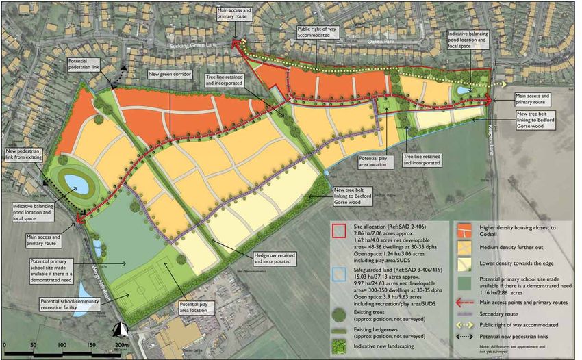
Section 1
INTRODUCTION
SECTION 1: INTRO DU C TI ON
                                                                                                                                               1. SIT
                                                                                                                                               2. INTERO
                                                                                                                                                       LODUCT   IONN
                                                                                                                                                          C AT IO

      PURPOSE OF THE DOCUMENT                                               provide an attractive amenity, as well as offer landscape,
                                                                            wildlife and ecology benefits. Supporting the ‘Development
1.1   This ‘Spatial Vision’ document has been produced in                   Framework’, information on technical issues such as utilities
      relation to land south of Codsall. It follows on from an              and highways have been fed into the process as well as
      earlier document submitted as representation to South                 planning policy issues.
      Staffordshire Council in 2013.This latest document has been
      prepared in the light of an amended site boundary illustrated   1.5   The report belongs to the authors and nothing should be
      within the Council’s Draft Site Allocation Document, which            copied or extracted without our approval.
      was issued following the 2013 representations. This Spatial           THE PROJECT TEAM
      Vision Document is to be submitted as part of the Site          1.6   The document has been prepared by, and under the
      Allocations Publication Plan public consultation which runs           direction of, the Keepers Lane project team. That team
      until 12 noon on Monday 27th February 2017 and will be                comprises the following principal consultants:
      sent to the independent Inspector who will preside over
      the public Examination, which is expected later in 2017.              John Williams, Managing Director of PlanIT
                                                                            Planning and Development Ltd.
1.2   As with the earlier document, this ‘Spatial Vision’ has
      been prepared to review the physical and environmental          1.7   John has over 30 years planning consultancy experience and
      constraints of land west of Keepers Lane, south of Codsall            significant expertise in bringing forward land for residential
      and also additional land to the east of Wergs Hall Road.              development. He has worked for private landowners,
      The document promotes the opportunity for this land to                developers, local authorities and local communities on
      be considered for residential development as part of the              different residential proposals across England and Wales.
      Council’s partial review of the South Staffordshire Green             His practice works with local communities to encourage
      Belt.The Core Strategy DPD recognises that land will need             them to connect with landowners and developers to ensure
      to be released from the Green Belt and Open Countryside               that new proposals address local concerns. The challenge
      in some locations at the Main and Local Service Villages              for all concerned is to expose the potential problems and
      to deliver the proposed development strategy and enable               issues associated with new development and to address
      the sustainable growth of these villages. The evidence in             those issues in a way which makes their impact acceptable.
      this document demonstrates that land south of Codsall is              Kenny Brown, Managing Director of Townscape
      not constrained in physical and environmental terms and               Solutions Ltd.
      is capable of contributing towards a sustainable pattern of
                                                                      1.8   Kenny has over 20 years experience in urban design in
      housing growth.
                                                                            the public and private sectors. He is a qualified Urban
1.3   To illustrate the ‘spatial vision’ for the land, the document         Designer and Town Planner and he has produced numerous
      includes a Development Framework Plan which sets out an               masterplans for a wide range of development projects
      initial land use and design concept for new development.              nationwide. He has also delivered key policy documents
      INFORMATION WITHIN THIS DOCUMENT                                      such as the Birmingham City Design Guide ‘Places for All’
                                                                            and the residential design guide ‘Places for Living’, as well as
1.4   The Development Framework illustrates how part of the                 contributing to national design policy.
      land ownership could be arranged to create an attractive
      residential development which will help to contribute           1.9   In addition to the above, the multi-disciplinary consultancy
      towards the area’s housing needs. New open space and                  BWB Consulting has provided supporting technical input
      woodland is also proposed on part of the land, which will             including transport, access and flood risk information.

LAND SOUTH OF CODSA L L: SPATI A L V I SI O N                                                                                                                                        4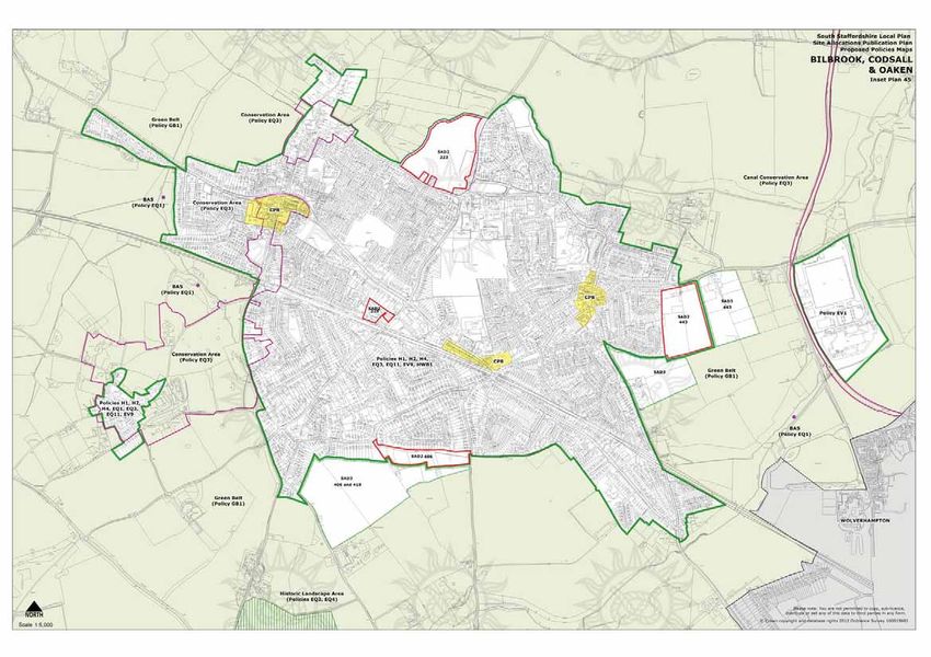
KEY
                                                                                                                       Site allocation (Ref: 406)
                                                                         ne     Oaken Park                             2.86 ha/7.06 acres approx.
                                                        Suckling Green La
                                                                                                                       Safeguarded land (Ref: 406/419)
                                                                                                                       15.03 ha/37.13 acres approx.

                                                                                  SAD2
                                                                                  406

                                                                                                  Keepers Lane
                                                                     SAD 3
                                                                     406/ 419
                    Wer
                        gs
                       Hall
                        Roa
                             d

                                                                                             Scale-1:2500 at A3

Figure 1: The land from the air (Source: Google Maps)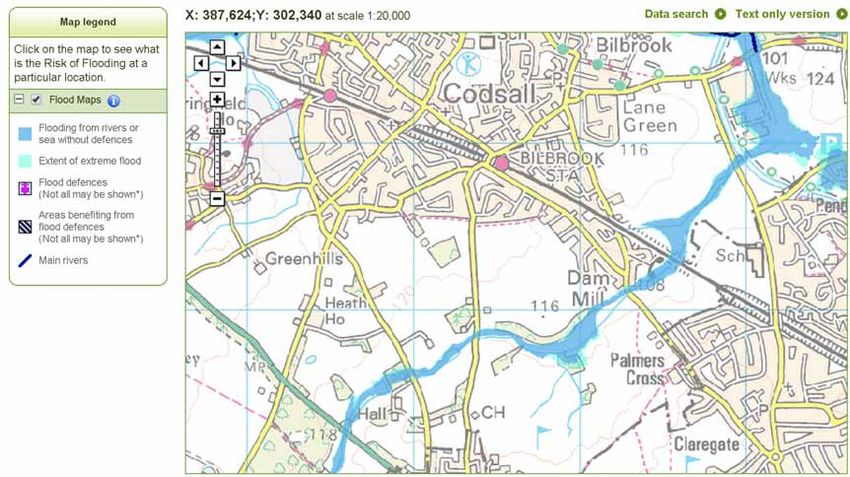
Section 2
SITE APPRAISAL
SECTION 2: S ITE APPRAI SAL
                                                                                                                                        2. SIT E A
                                                                                                                                                 LOP PCRAT
                                                                                                                                                        A ISA L
                                                                                                                                                           IO N

      LOCATION                                                          SITE LOCATION
2.1   The land south of Codsall is defined as two parcels. The
      first known as Site 406 (part) in the Council’s Draft Site
      Allocation Document is located to the west of Keepers
      Lane and south of Oaken Park and Suckling Green Lane
      in Codsall (see Figures 1-3). The second and larger parcel
      is identified in the Draft Site Allocation Document as Sites
      406 (part) and 419 and classified as safeguarded land for
      future development.

      OWNERSHIP

2.2   The site is split into 4 ownerships as identified in Figure 6
      (page 13). The four owners have agreed to work together
      to deliver a housing development on the site.

      SITE CHARACTERISTICS

2.3   The four land ownerships seen in Figure 6 extend to
      25.42 ha (62.81 acres), of which 17.89 ha (44.2 acres) is
      identified in the Local Plan. As Figure 3 overleaf illustrates,
      the allocated site measures 2.86 ha (7.06 acres) and the
      safeguarded land extends to 15.03 ha (37.13 acres). The
      extent and main features of the land are illustrated in
      Figure 4 (page 9).
2.4   The site allocation is currently comprised of housing,
      agricultural land and woodland. To the north of the site,
      gardens to housing adjoin the boundary and to the west
      and south lies the safeguarded land. The eastern edge is
      defined by Keepers Lane with open fields beyond.
2.5   The site is relatively flat with a gentle slope south to north.
      Overall there are few constraints to development and it is
      a suitable and available site for housing development.
      HISTORY
2.6   Figures 7 & 8 (page 14), contrast the historical evolution        Figure 2: Site Location, Scale- 1:25000 at A3, (OS Copyright)                       Site allocation (Ref: SAD 2-406)
      of the site and surroundings from 1903 with the present                                                                                               2.86 ha/7.06 acres approx.
      day. As the maps illustrate, Codsall has grown substantially                                                                                          Safeguarded land (Ref: SAD 3-406/419)
      in the intervening period and has expanded to meet the                                                                                                15.03 ha/37.13 acres approx.
      northern boundary of the site. The new development will
      continue the evolution of the area with the site forming a
      well located extension to the settlement.

LAND SOUTH OF CODSA L L: SPATI A L V I SI O N                                                                                                                                                                     7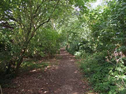
SITE BOUNDARY

                                                                         406

                                                               406/419

                                                                                      Site allocation (Ref: 406)
                                                                                      2.86 ha/7.06 acres approx.

                                                                                      Safeguarded land (Ref: 406/419)
                                                                                      15.03 ha/37.13 acres approx.

                                                                               Scale-1:2500 at A3

Figure 3: Site Boundary, Scale- 1:2500 at A3, (OS Copyright)

LAND SOUTH OF CODSA L L: SPATI A L V I SI O N                                                                           8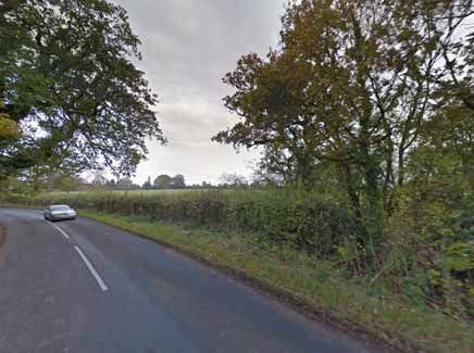
SECTION 2: S ITE APPRAI SAL
SITE ANALYSIS

                                                              Suckling Green Lane

                                                                                                                                             Keepers Lane
                                                                                                              Site allocation (Ref: SAD 2-406)
                                                                                                              2.86 ha/7.06 acres approx.
                                                                                    Bedford Gorse             Safeguarded land (Ref: SAD 3-406/419)
                                                                                    woodland                  15.03 ha/37.13 acres approx.

                                                                                                              Public right of way

                                                                                                              Existing trees
                                                                                                              (approx position, not surveyed)

                                                                                                              Existing hedgerows
                                                                                                              (approx position, not surveyed)
                                                                                                              Direction of slope
                                                                                                              (arrow pointing uphill)

                                                                                                              Existing ponds/watercourses
                                     We

                                                                                                              Existing buildings
                                        rg
                                        sH

                                                                                                              Note: All features are approximate and
                                         all

                                                                                                              not yet surveyed
                                             Ro
                                             ad

                                                                                                    1:2500 Scale at A3

Figure 4: Site Analysis, Scale-1:2500 at A3, (OS Copyright)

LAND SOUTH OF CODSA L L: SPATI A L V I SI O N                                                                                                                             9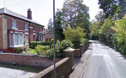
1
                                                        Suckling Green Lane           Oaken Park

                                                    8                             2                                     6
                                                                                                     3
                                                                                  5
                                                                                                     4

                                                                                                                            Keep
                                                                                                                                 e
                                                                                                                              rs La
                                                                                                                                ne
   9                                                                                        Bedford Gorse
                                                                                                                                     7
                                                                                            woodland

                 10
                     We
                        rg
                       sH
                         all R
                             oad

                                   11

Figure 5: Aerial oblique view and photo locations
                                                                                                            Site allocation (Ref: 406)
                                                                                                            2.86 ha/7.06 acres approx.

                                                                                                            Safeguarded land (Ref: 406/419)
                                                                                                            15.03 ha/37.13 acres approx.

LAND SOUTH OF CODSA L L: SPATI A L V I SI O N                                                                                                 10
Photo 1: Panoramic view of the existing entrance and house off Suckling Green Lane Photo 2:View east along the pedestrian right of way on the northern
edge
Photo 3:View north from the right of way to the houses on Oaken Photo 4:View west along the northern edge of Bedford Gorse Photo 5:View southeast to Bedford Gorse woodland in the
Park that back on to the site background
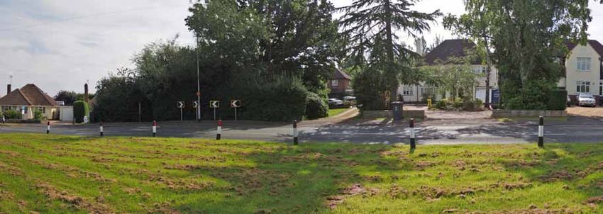
LAND SOUTH OF CODSA L L: SPATI A L V I SI O N 11Photo 6:View south down Keepers Lane past the suggested access Photo 7:View northwest from Keepers Lane across the field south of Photo 8:View south from Beech Gardens into the safeguarded land point to the allocated site the site Photo 9:View east from Wergs Hall Road to the northwest corner of Photo 10:View northeast from Wergs Hall Road across the centre of Photo 11:View northeast from Wergs Hall Road to the southwest the safeguarded land the safeguarded land corner of the safeguarded land adjacent to the garden centre LAND SOUTH OF CODSA L L: SPATI A L V I SI O N 12
SECTION 2: S ITE APPRAI SAL
                                                                       CONTEXT & OWNERSHIP

      LANDSCAPE AND GREENSPACE
2.7   The main areas of trees and hedgerows are identified in
      figure 4 (page 9). The woodland known as Bedford Gorse
      is the largest area of planting in the vicinity. Hedgerows and
      trees also define the field boundaries within the land in
      question. All of these areas of trees and hedgerows will be
      retained as far as possible.The land will be subject to a tree
      survey which will be carried out should the site reach the
      stage of a planning application.
2.8   As well as the retained trees and hedgerows, there is
      the opportunity to strengthen and improve the existing
      vegetation with new planting, as well as provide new                                                                                                       406
      landscaping within the developed areas.
      BUILT FORM
2.9   There is an existing house on the allocated site in the north
      west corner accessed from Suckling Green Lane. This has

                                                                                                                                                                                        Keepers Lane
      no special protection or specific design or heritage value.
      There are also a number of utilitarian agricultural buildings                                                           406/419
      behind the existing house to the south. Housing also backs
      on to the site along the northern boundary. The housing
      in the immediate area dates mainly from the 1930s to
      1950s with one and two storey examples. Sections 5 and 6
      examine the built context in more detail.

                                                                                                             We
                                                                                                                rg
                                                                                                               sH
                                                                                                                  all
                                                                                                                     Ro
                                                                                                                     ad
                                                                                                                                                   Scale-1:5000 at A3

                                                                       Figure 6: Context and ownership plan, Scale- 1:5000 at A3, (OS Copyright)

                                                                                Site allocation (Ref: 406)                     Mr R Howse (3.62 ha/8.94 acres           Mr P Smith (0.34 ha/0.84 acres)
                                                                                2.86 ha/7.06 acres approx.                     approx.)                                 approx.

                                                                                Safeguarded land (Ref: 406/419)                Mr J Jenks (8.58 ha/21.2 acres)          Cox family (12.88 ha/31.82 acres)
                                                                                15.03 ha/37.13 acres approx.                   approx.                                  approx.

LAND SOUTH OF CODSA L L: SPATI A L V I SI O N                                                                                                                                                                13
1903 MAP 2017 MAP
SITES SITES
© Crown Copyright and Landmark Information Group Limited 2013 all rights reserved. This map may not be reproduced without permission. 1674413418 County: STAFFORDSHIRE Scale: 1:10,560 Date: 1902-1903
Figure 7: 1903 map showing the site and the wider context of Codsall and Bilbrook before significant Figure 8: Present day map showing the growth of the Codsall and Bilbrook which have effectively coalesced
development took place. Very little development is present close to the sites at this time. into one large settlement. Development now extends along the entire northern boundary of the sites.
(Scale-1:20000 at A3, OS Copyright) (Scale-1:20000 at A3, OS Copyright)
LAND SOUTH OF CODSA L L: SPATI A L V I SI O N 14Section 3 PLANNING CONTEXT
SECTION 3: P L A NNING C O N TE XT
                                                                                                                                              3. P LA NNING CO NT EXT

      PLANNING BACKGROUND                                               3.6   Core Strategy Policy 1 recognises that some land will need           •     Connectivity to existing open space including
                                                                              to be released from the Green Belt and Open Countryside                    woodland and Public Rights of Way, SUDs and new
3.1   This section examines the planning issues raised by the                 in some locations at the Main and Local Service Villages to                open space to be delivered on site.
      proposals including local policy and housing need issues.               deliver the proposed development strategy and enable the
                                                                                                                                                   SAD3. Safeguarded Land
3.2   Local policy has of course been prepared in the light of                sustainable growth of these villages.
      the National Planning Policy Framework (NPPF) which                                                                                          •     Vehicular access off Wergs Hall Road
                                                                        3.7   After a partial review of the Green Belt, the Council has
      must be taken into account in the preparation of local and              published the final Publication Plan of the Site Allocation          •     The delivery of safeguarded land to explore the
      neighbourhood plans.                                                    Document (SAD). This plan allocated housing sites which                    delivery of a through road from Keepers Lane to
3.3   At the heart of the NPPF is a presumption in favour of                  align to the aims and objectives within the adopted Core                   Wergs Hall Road to relieve traffic pressure on the
      sustainable development. We believe that the land to the                Strategy. The SAD has been prepared over a three year                      village
      south of Codsall is a sustainable choice of site for new                period and its proposals have been evaluated having regard
                                                                                                                                                   •     The delivery of safeguarded land in Codsall and
      housing as explained below.                                             to responses during its consultation stages.
                                                                                                                                                         Bilbrook may need to come forward in conjunction
                                                                        3.8 The final Publication SAD identifies land at Keepers Lane/                   with the strategic delivery of a new primary school to
      POLICY FRAMEWORK                                                      Wergs Hall Road for removal from the Green Belt and as                       meet the primary education needs of both villages’.
                                                                            safeguarded land (Policies SAD 2 and SAD 3 respectively).
3.4   South Staffordshire has progressed its replacement Local                                                                                3.12 The area of the site identified for development is only
                                                                            The extent of the site which is affected by both policies
      Plan through the adoption of the Core Strategy DPD.                                                                                          Grade 3 agricultural land. Development will therefore not
                                                                            is shown in the extract from the Local Plan illustrated in
      The Core Strategy provides a framework for a new                                                                                             take up the best and most versatile agricultural land.
                                                                            Figure 8.
      development strategy for the period to 2026.That strategy                                                                               3.13 In terms of heritage and landscape value, apart from the
      identifies Codsall and neighbouring Bilbrook as higher            3.9   The Allocated land (Site 406) should be brought forward
                                                                                                                                                   green belt designation, the site has no special landscape
      order, or Main Service, villages which will be the focus for            for development within the plan period; Policy SAD2 states
                                                                                                                                                   character protection.
      housing and employment growth. The Council propose                      that it is suitable for a minimum of 50 new homes. This site
      that approximately 90% of the District’s housing growth                 will contribute to the District’s immediate housing needs.      3.14 With regard to built form and character, the Village Design
      will take place in these villages. That status reflects their                                                                                Statement provides detailed policy advice. Page 70 provides
                                                                        3.10 The Safeguarded Land will, in accordance with Policy SAD3,
      accessibility to existing services, their connections to public                                                                              a set of design principles to take into account:
                                                                             extend over an area of circa 15 hectares (site reference
      transport including rail, and their close connections to the           406 and 419).This part of the site will retain its safeguarded        a. Create new character areas
      new I54 employment site which is the largest employment                land designation until a review of the Local Plan.
      land allocation within the area.                                                                                                             b. Streetscape enhancement
                                                                        3.11 The SAD provides an assessment of both the allocated and              c. Landscaping of car parking areas
3.5   The Core Strategy sets out a vision and set of plan making             safeguarded sites. This assessment also suggests criteria
      objectives for 5 locality areas across South Staffordshire             to help with the preparation of planning applications. The            d. Enhance the diversity of the built stock
      Distrct. Codsall is within Locality Area 4 and the Locality            assessment is on pages 66 and 67 of the SAD; relevant                 e. Enhance the village entrances
      Model is set out on page 29 of the Core Strategy. In                   extracts are set out below.
      summary it states that affordable housing to meet local                                                                                      f. Maintain views out into the countryside
      housing needs will have been delivered on suitable sites                1. SAD2 Allocation
                                                                                                                                                   g. Strengthen the Green Belt edge
      and the villages of Codsall, Bilbrook and Perton will have              •     Pedestrian access to connect to existing pavement
                                                                                                                                                   h. Enhance the green space network
      developed their key roles as the main service villages.                       network
      The land at Keepers Lane could help to achieve these key                                                                                3.15 All of the above principles will be inherent within any
                                                                              •     Strong landscape boundaries to be maintained and
      objectives and should be considered to meet the housing                                                                                      development proposal for the site.
                                                                                    implemented to contain smaller site in a larger parcel
      targets in Core Policy 6 for Codsall.
                                                                              •     Maintain Public Right of Way on north boundary

LAND SOUTH OF CODSA L L: SPATI A L V I SI O N                                                                                                                                                                      16
MEETING THE NEED FOR HOUSING 3.21 As well as future housing opportunities, the safeguarded
land potentially offers the potential for a new primary
3.16 Government projections indicate that the population is school and recreation land. There are two Development
growing, and with demand further compounded by falling Framework options set out in Section 5, one of which
average household size, the result is a well documented illustrates the this possibility.
mismatch between the supply and demand for housing.The
NPPF therefore encourages local authorities to “boost
significantly the supply of housing” by ensuring their Local
Plan meets the full, objectively assessed needs for market
and affordable housing over the plan period.
THE KEEPERS LANE OPPORTUNITY
3.17 The land at South Codsall could make a significant
contribution towards meeting the needs for housing within
the district in a highly sustainable location.
3.18 Apart from the right of way that runs along the northern
boundary, public access to the land is currently restricted
since it is in private ownership. A sensitive and limited
area of development would deliver not only much needed
housing but also potentially a new play area and landscaping/
open space benefitting the existing community as well as
new residents. Development would be confined to those
areas with the least landscape impact and would be entirely
appropriate in character terms given that the site already
adjoins housing at the moment.
3.19 On this basis the opportunity exists to achieve a sensitive
development for housing and woodland/open space on
land that is already identified through the SHLAA as being
developable (see Figure 9 overleaf).This document has also
explained that the landowners have come to an agreement
which would make it deliverable.
3.20 The site also has many advantages over some other
suggested sites such as its close proximity to existing
services including the railway station and shops (see Figure
10, page 21). Sections 5 and 6 explain the proposals in more
detail.
LAND SOUTH OF CODSA L L: SPATI A L V I SI O N 17SECTION 3: PL A NNING C O N TE XT
SITES
Figure 9: Map extract from the Local Plan identifying the land, (Not to Scale, OS Copyright)
LAND SOUTH OF CODSA L L: SPATI A L V I SI O N 18Section 4 TECHNICAL ASSESSMENT
SECTION 4: TECHNIC AL AS S ES S ME N T
                                                                                                                                             4. TSIT
                                                                                                                                             2.   ECH  NIC
                                                                                                                                                     E LO CA
                                                                                                                                                           ATL IO
                                                                                                                                                                A SSESSMENT
                                                                                                                                                                   N

      TECHNICAL CONSIDERATIONS                                               MIX OF HOUSING                                                  4.8   There is sufficient space within the site to provide the
                                                                                                                                                   necessary access arrangements for the full or part
4.1   So far general site features and planning issues have been       4.4   Any subsequent development will incorporate a mix of                  development of the site. Further work would be required
      examined. This section examines more detailed technical                house types and tenures. Policy H2 of the Core Strategy               in terms of undertaking a topographical survey in order
      issues with a view to determining the appropriate amount               requires 40% to be made up of affordable housing on                   to provide a detailed design of the access arrangements.
      of housing. The technical considerations include:                      greenfield land. The Council has set an initial target of 50%         Appendix 1 however illustrates a number of preliminary
      •     Scale of housing;                                                of the affordable housing on a sites to be social rented and          access solutions.
                                                                             50% intermediate tenures and the precise proportion will
      •     Mix of housing                                                   be agreed with the Council. The precise mix of affordable       4.9   Further assessments would also be required in terms of
                                                                             housing (by type, size and tenure) will be agreed with the            the junction capacity assessments and trip distribution.
      •     Utility services;                                                                                                                      This would be undertaken as part of any formal transport
                                                                             Council as part of the planning application process. In
      •     Access and connectivity;                                         general the site could however provide between 19 to                  planning document that would be submitted as part of any
                                                                             22 affordable houses on the allocated site and 120 to 160             planning application. This would however not be a limiting
      •     Landscape and open space;                                                                                                              factor as any issues could be mitigated through localised
                                                                             houses on the safeguarded land depending on the density
      •     Ecology;                                                         and potential for other uses.                                         highway improvements and sustainable transport strategies.

      •     Flood Risk;                                                                                                                      4.10 There is flexibility in terms of access to the allocated site,
                                                                             UTILITY SERVICES                                                     with access from both Keepers Lane and Suckling Green
      •     Noise;                                                                                                                                Lane being possible. Access to the safeguarded site can be
                                                                       4.5   Subject to further investigation, there are likely to be             provided from Wergs Hall Road with the further potential
      •     Built form and character
                                                                             few constraints with regard to utility easements. It is              to link through to Keepers Lane.This linkage also offers the
4.2   The project team will be spending time with the key                    understood that the site and its surrounds are well served           possibility of an alternative route to relieve traffic through
      stakeholders and the decision makers to understand the                 by high and low voltage electricity, gas, water, telecoms and        Codsall. Any preferred solution will emerge from further
      main issues which are of concern to the local community.               public sewer infrastructure. At this preliminary stage, it is        discussions with the Highways Authority.
                                                                             considered that the provision of strategic services to the
      SCALE OF HOUSING                                                       site should not be problematical. However, at the time of       4.11 If bus access is required within the site, there is sufficient
                                                                             preparing this report, there had been no dialogue with the           space to be able to provide the required geometry that
4.3   The developable area on the allocated site would result in             relevant statutory undertakers in this regard. Furthermore,          such an access would require.
      approximately 48-56 dwellings depending on the density.                it is not anticipated that there are any public services
      The safeguarded land would result in approximately 300-                situated within the site boundary therefore it is unlikely            LANDSCAPE & OPEN SPACE
      400 dwellings dependent on density and whether a primary               that any diversionary works will be required to facilitate      4.12 A landscape and visual impact assessment has not yet been
      school/recreation land would be required. It is likely that it         the on-site development proposals. Further investigations            carried out but would be provided if the site were accepted
      would be on the lower end of that scale given the edge                 with regard to utilities will however be undertaken at               for development. It is clear however that the location of
      of settlement context, however character and landscape                 the appropriate time should a planning application come              the site adjacent to existing development, together with
      impact has of course to be balanced with the need to                   forward.                                                             the existing and proposed areas of woodland and screening
      optimise the potential of the site as set out in paragraph 58
                                                                                                                                                  would limit any landscape impact of development.
      of the NPPF. Further design and capacity exercises would               ACCESS & CONNECTIVITY
      therefore determine the optimal figure at a later date if                                                                              4.13 With regard to open space, new play space would be
      the principle of housing development was agreed. From            4.6   The proposed site is deliverable in terms of access and              provided as part of the planned development. This is
      the work carried out so far however, it is clear that from             transport for providing a residential scheme for promotion           illustrated and explained in more detail within the next
      technical standpoint these figures are achievable.                     within the Site Allocations DPD.                                     section. Furthermore the additional areas of open space
                                                                       4.7   The site benefits from excellent connectivity to the                 proposed would also provide informal recreational
                                                                             existing pedestrian and public transport facilities and the          opportunities accessible to existing and future residents.
                                                                             local facilities within Codsall.

LAND SOUTH OF CODSA L L: SPATI A L V I SI O N                                                                                                                                                                        20
SECTION : P L A NNING C O N TE XT
FACILITIES &
ACCESSIBILITY
Site
400m radius/
5 min walk
800m radius/
10 min walk
1200m radius/
15 min walk
Railway Station
Nearest bus stops
Pedestrian routes
SITES
Shops and services
Schools
Figure 10: Wider Context & Accessibility, Scale-1:10,000 at A3 (OS Copyright)
LAND SOUTH OF CODSA L L: SPATI A L V I SI O N 21SECTION 4: TECHNIC AL AS S ES S ME N T
ECOLOGY
4.14 An ecological study has not been carried out as yet. If
accepted as a development site this would be undertaken
within the appropriate seasons. In general however the
likely areas of ecological potential including tree belts,
hedgerows and ponds will be retained. It is also proposed to
provide planting and open space as part of the development.
There is therefore the potential that the ecological value of
the site will increase following development with suitable
mitigation and planting to support wildlife.
FLOOD RISK AND WATER SITES
4.15 The site is not within a flood zone and there should not
be any flooding constraints in principle (see Figure 11).
Further details on surface and foul water strategies are
being investigated, and a strategy would be provided as
part of any planning application, however no major issues
are anticipated. Indicative attenuation ponds are illustrated
on the Development Framework options as part of a
preliminary strategy.
NOISE
4.16 There are no significant noise sources close to the site.
Keepers Lane, Suckling Green Lane and Wergs Hall Road
are not busy roads and noise should not be a constraint to Figure 11: Flood Risk map (Source: The Environment Agency, Scale-1:25,000 at A3 (OS Copyright)
development.
of 1930s villas with features including bay windows and
BUILT FORM & CHARACTER timber framing. There are also a few scattered examples of
older cottages which were built before the housing estates
4.17 There is an existing house and agricultural buildings on the existed. Oaken Lanes north of Wergs Hall Road also
north west corner of the allocated site but otherwise the contains older buildings of character including Edwardian
site is undeveloped. The safeguarded site has no structures villas.
within the land.
4.19 Local housing examples are illustrated overleaf. A mix of
4.18 In terms of the site and immediate surrounding townscape, the better quality design approaches could justifiably be
there are no heritage assets including conservation areas applied to the site.
or listed buildings. The built form is comprised of largely
4.20 With regard to building heights, most nearby examples are
post war detached and semi-detached two storey houses
1.5-2 storeys supplemented with bungalows.
and bungalows which are pleasant if largely unremarkable
in terms of distinctiveness. The housing with the most 4.21 Overall built form and character is not likely to be a
distinct character is located to the north east on Keepers constraint subject to a suitable design response in terms of
Lane and on Suckling Green Lane which contain examples layout and appearance.
LAND SOUTH OF CODSA L L: SPATI A L V I SI O N 22SECTION 4: TECHNIC AL AS S ES S ME N T LOCAL STREETS AND BUILDINGS Photo 8:- 1930s villas on Suckling Green Lane to the north west of Photo 9- More 1930s villas on Keepers Lane to the north east of the Photo 10- 1950s bungalows on Oaken Park to the north of the site the site site set in generous landscaping Photo 11- Mix of 1 and 2 storey 1950s houses on Oaken Park to the Photo 13- Example of an older vernacular cottage on Suckling Green Photo 13- Edwardian villas on Oaken Lanes north of the site Lane which predates the post 1930s housing estates LAN D SOUTH OF CODSA L L: SPAT I A L V I SI O N 23
Section 5
THE SPATIAL VISION
SECTION 5: THE S PATIAL VIS I ON
5. TSIT
2. H EE SPAT
LO C IA
ATLIO
V ISIO
N N
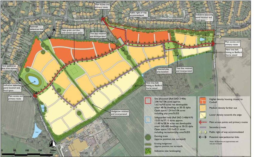
THE OVERALL VISION 5.6 This range of densities allows for an efficient use of the 5.12 Development Framework Option 1 shows 3.9 ha of open
site, balanced with site constraints. Densities will reduce space in total with 3.55 ha shown on Option 2 which
5.1 This section considers how a proposed scheme can to provide a looser grain towards the edge and allow a exceeds the standards.
respond to the issues which have been referred to in well landscaped setting. The Development Framework
the preceding sections and illustrates and explains two 5.13 At this stage the plan is conceptual and broad brush. The
plans (Figures 12 & 13, pages 28-29) show an indicative Fields in Trust figures relates solely to recreation space.
proposed Development Framework options. The overall density gradient. The actual amount of units proposed will
vision is one of a distinctive yet sensitive development There are also Core Strategy policy requirements including
be refined after further masterplanning work is carried out the following:
which complements the site and surroundings in terms of if the proposals are accepted.
built form and landscaping. • Policy EQ1: Protecting, Enhancing and Expanding Natural
5.7 In terms of the amount of open space, the Council currently Assets
APPROPRIATE USES does not have any quantitative standards although the LPA
5.2 The main uses proposed are housing, open space and proposes to include these in a future Open Space, Sport • Policy EQ4: Protecting and Enhancing the Character and
woodland. Housing is compatible with the residential and Recreation SPD. Nevertheless as described above, Appearance of the Landscape
context to the north and will cater for a range of local provision has been made for open space on the site with a • Core Policy 4: Promoting High Quality Design
housing needs including affordable housing. The open range of different spaces.
• Policy EQ11: Wider Design Considerations
space in the form of a new play area, new woodland belts 5.8 The open space is in line with the NPFA (Fields in Trust)
and informal open space will provide a facility not just for • Policy EQ12: Landscaping
standard of 2.43 ha per 1000 people which was set out in
the site but also for the wider community fulfilling a local the old 1996 Local Plan. This includes 1.6-1.8 ha for youth • Core Policy 14: Open Space, Sport and Recreation
need and make public land that is currently private. There and adult recreation and 0.6-0.8 ha for children’s play. South 5.14 These require other forms of space such as the landscape
is also the potential for a primary school and recreation Staffordshire average household size is 2.4 people (2011 buffers, attenuation ponds and habitat retention/
land which will be subject to further investigation and Census). enhancement which the Development Framework plans
consultation.
5.9 On the allocated land, up to 56 dwellings = 134 people also provide.
AMOUNT requiring 0.32 ha of open space including 0.08-0.1 ha of ACCESS
5.3 The site area of the allocation (Ref: SAD 2-406) measures children’s play space. The Development Framework shows
1.24 ha in total including 0.1ha play space. The excess open 5.15 The main access points proposed have been determined
approximately 2.86 ha/7.06 acres with 1.62 ha/4.0 acres
space takes the form of the land adjacent to the right of in part by the initial transport assessment to allow for the
net developable area which would provide 48-56 dwellings
way, the indicative attenuation pond and the hedgerows/ amount of dwellings proposed as well as offering suitable
at 30-35 dpha. The amount of open space would equal 1.24
tree belt. In addition there is buffer planting/landscape and convenient locations. As stated, the site can be accessed
ha/3.06 acres including play area/SUDS measures.
mitigation along the southern edge of the allocated land from Suckling Green Lane and/or Keepers Lane as well as
5.4 With reference to the safeguarded land, (Ref: SAD Wergs Hall Road with regard to the safeguarded land. The
which becomes part of a green link through the safeguarded
3-406/419) the site area measures approximately 15.03 exact location(s) and detailed design can be agreed with
land in the longer term. This also provides landscape
ha/37.13 acres. Option 1 would provide 9.97 ha/24.63 acres officers following further work.
benefits in terms of breaking up the development mass.
net developable area with 300-350 dwellings at 30-35 dpha
On this relatively small site it is unlikely that youth/adult 5.16 The site is well situated for access to public transport and
and open space measuring approximately 3.9 ha/9.63 acres
recreation space would be required. local facilities. Bus stops, the railway station and shops and
including recreation/play area/SUDS space. In addition a
5.10 With regard to the safeguarded land, up to 350 dwellings local facilities are within 5 -10 min walk of the site.
potential location for a primary school measuring 1.16 ha
(2.86 acres) is also illustrated should it be required.There is on Option 1 = 840 people requiring 2.04 ha of open space. 5.17 The topography is such that there will be no barriers to
a the potential for a dual use school/community recreation This could potentially include 0.5 ha- 0.67 ha of children’s movement in terms of difficult level changes.
facility with this option. play space and 1.34 ha- 1.51 ha of youth/adult recreation
5.18 Car parking will be conveniently located for access to the
space.
5.5 Option 2 would provide 11.48 ha/28.36 acres net units and in line with local authority requirements.
developable area with 345-400 dwellings at 30-35 dpha and 5.11 Option 2 (960 people) would require 2.33 ha of open space.
open space measuring approximately 3.55 ha/9.21 acres This could potentially include 0.57 ha- 0.76 ha of children’s
including the play area and SUDS space. play space and 1.53 ha- 1.72 ha of youth/adult recreation
space.
LAND SOUTH OF CODSA L L: SPATI A L V I SI O N 25SECTION 5: THE S PATIAL VIS I ON
SCALE 5.25 Areas of blank wall would also be minimised and it is • Tree and shrub planting will be carried out with a
5.19 In terms of scale there are few examples of development suggested that corners are turned by way of special corner suitable species in liaison with the Council;
above two storeys in the area. Given the lower density, turning units which are double fronted with windows to
• Low walls, railings and hedges will define front
low scale nature of surrounding development, buildings are both returns.
boundaries. Hedges are particularly appropriate to
proposed to be no more than two storeys in the main, 5.26 Other features could include: the site and existing hedges will be incorporated
although there may be opportunities for limited taller • Generally a perimeter block form with public fronts where possible;
buildings at focal points and key locations. Over time the and private backs;
mainly two storey development combined with existing and • Use of verges and hedge planting alongside the
proposed landscaping will ensure a sensitive integration of • Active frontages throughout with buildings facing on carriageway also echoes the existing character;
the development into the landscape. to public areas; • Surface materials will include the use of asphalt,
LAYOUT • Use of defensible planting and defensible space in block paving and concrete paving slabs with details
front of properties; reserved;
5.20 The indicative layout in the form of the Development
Framework plans (Figures 12 and 13) is broad brush at this • Where there are pedestrian only links these would DESIGN & APPEARANCE
stage but it does indicate a structure which has evolved be well overlooked; 5.29 As with landscaping, the design and appearance of the
from taking account of site characteristics, and local scheme is at an early stage, however some basic principles
character. As well as addressing the issue of impact on the • All public open space to be well overlooked from the
proposed properties to provide natural surveillance. can be outlined. As suggested in Section 4, the intention is
landscape, the aim is to provide a well connected and easily to take some reference from the best examples of housing
understood layout in line with good practice including ‘By LANDSCAPING AND GREEN SPACE found locally. Design precedents found locally that could
Design’ and ‘Manual for Streets’ as well the requirements inform the design are set out earlier on page 23 particularly
5.27 The plan is at an early stage of development therefore a
within local policy. the pre-war examples.
detailed landscaping scheme has not been prepared so
5.21 In general the street pattern is fairly formal and linear far. The Development Framework plans show indicative 5.30 Local traditional architecture can be used as a reference
sympathetic to the local suburban examples to the north. landscaped areas illustrating broad principles. with a traditional or modern interpretation acceptable
The density and formality is likely to reduce towards the as long as it is of sufficient quality with a close attention
5.28 The proposal for the site will include landscape
south closer to the development edge as the Development to detail. Quality design is the key, although the detailed
enhancements.This will include planting within the confines
Framework plans indicate. appearance will be worked up later in consultation with
of the proposed gardens of residential properties, the
5.22 Streets would generally link up ensuring a permeable and wider street scene and the public open space. Building on the planning authority.
walkable layout with easy links to the play area(s) and to the the analysis in Section 4, the landscape strategy will create 5.31 Features found locally that references could be made to,
existing pedestrian right of way running along the northern a continuation of the local landscape character. include:
boundary.
This will include: • Prevalent use of detached and semi-detached units
5.23 The amenity of existing houses to the north has also in a landscaped setting with complementary terraced
• Strengthening of field boundaries using native
been considered and a suitable separation distance will be housing;
hedgerow planting;
provided along with the retention of the existing trees and
opportunities for further screening are available if required. • A new belt of native woodland and open space on • Some use of bay windows and gables;
the southern part of the safeguarded site; • Use of brick and render facing materials;
DESIGNING OUT CRIME
5.24 In terms of safety and security, the layout can ensure all • Well overlooked play area(s) providing convenient • Hipped and gable roofs with tile covering.
public areas are overlooked by frontages and parking is to access to all residents including the wider existing
be visible and/or within secure curtilages. community;
LAND SOUTH OF CODSA L L: SPATI A L V I SI O N 26SUSTAINABILITY CONTACT DETAILS
5.32 Positive sustainability benefits will be provided including: For further information regarding the land at Keepers Lane
please contact:
• Accessible location and permeable layout allowing
easy pedestrian and cycle movement as an alternative John Williams
to car use; Planit Planning & Development Ltd,
• Efficient use of land that balances density with The Steeples,
character;
Mulberry Court,
• Retention of existing trees and hedgerows where
Stockton on Teme
possible;
Worcestershire
• Further detailed sustainability measures will be
proposed at the planning application stage. WR6 6UT
SUMMARY & CONCLUSION
T: 01584 881038
5.33 This document, together with the Development Framework E: johnwilliams2012@btinternet.com
Plans offers a sensitive and considered approach to the
development of land at Keepers Lane for new housing,
open space and woodland.
5.34 It demonstrates how this site could make a valuable
contribution towards meeting the need for housing in the
area within a compact and sensitively designed urban form.
5.35 The development will also secure a generous amount of
open space including an equipped children’s play area and a
new area of woodland and open space benefitting existing
as well as new residents.
5.36 The document has examined planning policy issues and
also demonstrated that there are no technical constraints
preventing a development of up to 56 dwellings on the
allocated site and between 300 and 400 houses coming
forward on the safeguarded site.
5.37 Accordingly, this site should be allocated for residential
development within the adopted Site Allocations DPD.
LAND SOUTH OF CODSA L L: SPATI A L V I SI O N 27SECTION 5: THE S PATIAL VIS I ON DEVELOPMENT FRAMEWORK OPTION 1 Figure 12: Development Framework Option 1, Scale-1:3000 at A3 (OS Copyright) LAND SOUTH OF CODSA L L: SPATI A L V I SI O N 28
SECTION 5: THE S PATIAL VIS I ON
DEVELOPMENT FRAMEWORK OPTION 2

Figure 13: Development Framework Option 2, Scale-1:3000 at A3 (OS Copyright)

LAND SOUTH OF CODSA L L: SPATI A L V I SI O N                                   29
Appendix 1
ACCESS DRAWINGS
2 - Keepers Lane Access Notes
1 - Suckling Green Lane Access 12 1. Do not scale this drawing. All dimensions must be
checked/ verified on site. If in doubt ask.
12a
10
42
2. This drawing is to be read in conjunction with all
relevant architects, engineers and specialists drawings
40
and specifications.
2
3. All dimensions in millimetres unless noted otherwise. All
levels in metres unless noted otherwise.
30mph speed limit continued past
47
ghost island junction 4. Any discrepancies noted on site are to be reported to
the engineer immediately.
30.0 metre length taper
Mancroft
2.0 metre wide footway
49
3.0 metre wide through-lanes Key Plan
126.2m
29
17
159
4
nd
2
Hasla
19
18 34
16
The Bentlands
1
(PH)
18
36
13 lands
Wood
The
38
49
37
20
17 78
78a
25 124.4m 59
79
LB
16
24
25
26
27
82 69
21
El Sub Sta
102
73
14
25
31
36
48
87
99
21
28
14
41
12
12a
27
Existing footway to be extended south to the
10 106
88
40
35
48
68
40
Sta
109
13
1
El Sub
36
56
96
89
22
94
2
48 Sub El
44
Suckling Green Lane visibility splay
2.4m x 43m
(tangent to kerb) Sta
44
PROW and proposed dropped kerb crossing point
El Sub Sta
127.0m Existing PRoW to form
13
Lane
splay pedestrian/cycle access
2.4m x 43m visibility
(tangent to kerb)
2
45
Suckling Green
6.0 metre corner radii 48
bility splay
Possible dropped kerb pedestrian crossing point 24
53 63 1
1
5.5 metre wide carriageway
58 34
45
2.4m x 43m visi
53
63 47
42
14
2
30mph speed limit continued past
Path (um)
47
ghost island junction
30.0 metre length taper
Mancroft
47
(tangent to kerb)
2.0 metre wide footway
49
3.0 metre wide through-lanes
126.2m
Existing footway to be extended south to the
PROW and proposed dropped kerb crossing point
Path (um)
2.4m x 43m visibility splay
nearside kerb
to 2.0 metre wide footway at
PROW access point
Pond
5.5 metre wide carriageway
1.5 metre wide central pedestrian refuge
in line with DMRB 42/95 Standards
Proposed central refuge islands
2.4m x 43m visibility splay to
38.0 metre length taper
Keepers Lane carriageway speed limit to be reduced to
30mph for entire length of ghost island
2.4m x 43m visibility splay to nearside kerb
Track
nearside kerb 2.0 metre wide footway at Pond 30mph designated speed limit
approaching ghost island
Existing PRoW to form PROW access point
127.0m bility splay
pedestrian/cycle access
Pond
123.7m
Pedestr
provisio
extents
ian - subject
footway
n
5.5 metre wide carriageway
to
link
to
highway
Wergs
into
2.4m x 43m visi
existing
Hall
Bedford Gorse
boundar
Road
y
2.4m
(tangen
x
43m kerb)
t to
visibility
72m
taper
splay
1.5 metre wide central pedestrian refuge
length
122.8m
provided
b)
2.0
metre
(tangent to ker
wide
footway
Propose
d
central
refuge
5.5
metre
islands
3
wide
x
3.0
carriage
metre
in line with DMRB 42/95 Standards
wide
way
2.4m
lanes
(tangen
x
43m kerb)
t to
visibility
splay
Pond
72m
taper
3
length
provide
45
d
124.7m
Mast
Existing
5.1m
wide
carriage
way
of
Wergs
Proposed central refuge islands
Hall
Road
6.0 metre corner radii
2.4m
(tangen
x
215m
t to
kerb)
visibility
splay
117.3m
Ordnance Survey, (c) Crown Copyright 2017. All rights reserved. Licence number 100022432
Possible dropped kerb pedestrian crossing point
Garden Centre
El Sub Sta
38.0 metre length taper
Keepers
Cottage
112.5m
Pond
Bedford
5.5 metre wide carriageway
Spinney
Dra
in
121.9m
Pinetrees
River Penk
Swimming Pool
Field Manor
Keepers Lane carriageway speed limit to be reduced to
Ordnance Survey, (c) Crown Copyright 2013. All rights reserved. Licence number 100022432
2.4m x 43m visibility splay to nearside kerb
30mph for entire length of ghost island Legend
53
47
30mph designated speed limit
approaching ghost island
3 - Wergs Hall Road Access 2.4m x 43m visibility splay
2.0 metre wide footway
(tangent to kerb)
5.5 metre wide carriageway
Pedestrian footway to link into existing
provision - subject to highway boundary
3 x 3.0 metre wide lanes P3 08.02.17 PRELIMINARY ISSUE TG AO
extents
P2 06.02.17 PRELIMINARY ISSUE TG TC
P1 20.01.17 PRELIMINARY ISSUE SR TC
Rev Date Details of issue / revision Drw Rev
8m
2.4m x 43m visibility splay
(tangent to kerb) Issues & Revisions
2.
12
Birmingham | 0121 233 3322
Leeds | 0113 233 8000
London | 020 7234 9122
Manchester | 0161 233 4260
CONSULTANCY | ENVIRONMENT Nottingham | 0115 924 1100
INFRASTRUCTURE | BUILDINGS
www.bwbconsulting.com
Client
nd
Po PLAN IT PLANNING AND
Wergs Hall Road 72m taper length provided DEVELOPMENT LTD
2.4m x 215m visibility splay
(tangent to kerb)
7m
4.
12
Proposed central refuge islands Project Title
KEEPERS LANE, CODSALL
72m taper length provided
Drawing Title
SITE ACCESS
ARRANGEMENTS
Existing 5.1m wide carriageway of Wergs Hall Road
Drawn: Simon Raywood Reviewed: Tim Cooke
BWB Ref: BMT2308 Date: 20.01.17 Scale@A3: 1:1000
Drawing Status
PRELIMINARY
Project - Originator - Zone - Level - Type - Role - Number Status Rev
KLC-BWB-HML-XX-DR-TR-001 S2 P3
k Copyright BWB Consulting LtdYou can also read