Landslides Triggered by the 2020 Qiaojia Mw5.1 Earthquake, Yunnan, China: Distribution, Influence Factors and Tectonic Significance
←
→
Page content transcription
If your browser does not render page correctly, please read the page content below

Journal of Earth Science, Vol. 32, No. 5, p. 1056–1068, October 2021                                                   ISSN 1674-487X
Printed in China
https://doi.org/10.1007/s12583-021-1492-1

    Landslides Triggered by the 2020 Qiaojia Mw5.1 Earthquake,
       Yunnan, China: Distribution, Influence Factors and
                       Tectonic Significance
                     1, 2
     Xiangli He             , Chong Xu *1, 2, Wenwen Qi1, 2, Yuandong Huang3, Jia Cheng1, Xiwei Xu1, Qi Yao4,
                                                Yongkun Lu5, Boyang Dai5
          1. National Institute of Natural Hazards, Ministry of Emergency Management of China, Beijing 100085, China
      2. Key Laboratory of Compound and Chained Natural Hazards Dynamics (Under Construction), Ministry of Emergency
                                            Management of China, Beijing 100085, China
                                     3. China University of Geosciences, Beijing 100083, China
                                    4. China Earthquake Networks Center, Beijing 100045, China
                                       5. Yunnan Earthquake Agency, Kunming 650224, China
              Xiangli He: https://orcid.org/0000-0002-2863-4457; Chong Xu: https://orcid.org/0000-0002-3956-4925

           ABSTRACT: On May 18, 2020, an Mw5.1 earthquake occurred in Qiaojia County, Yunnan Province, China.
           This moderate-sized event triggered massive coseismic landslides, resulting in some damage. In this work,
           through visual interpretation of high-resolution (0.8–2 m) Gaofen satellite images before and after the earth-
           quake, 167 landslides were delineated, 18 of which were inspected in the field. Using the landslide number
           density (LND) and landslide area percentage (LAP), we characterized the spatial distribution of these land-
           slides, and analyzed their possible influence factors and tectonic significance. The results show that these
           landslides are distributed mostly in the NW-SE direction, roughly parallel to the long axis of seismic intensity
           zones and the strike of the Xiaohe-Baogunao fault (XBF). The LND and LAP decrease with increasing dis-
           tances to the fault and from the epicenter to fault ends of the XBF. These permit to suggest that the seismo-
           genic fault of the Qiaojia earthquake is likely a hidden branch of the XBF. All of the landslides induced by
           this event occurred in the region with the seismic intensity of six degrees or greater of the 2014 Mw6.2 Ludian
           earthquake. Therefore, it was inferred that the 2020 Qiaojia earthquake was probably the subsequent release
           of accumulated elastic strain after the 2014 Ludian earthquake in a same tectonic stress regime.
           KEY WORDS: Qiaojia earthquake, landslide inventory, spatial distribution, seismogenic fault, Ludian earth-
           quake.

0    INTRODUCTION                                                    commonly accepted landslide-mapping principles, many detailed
      Many studies have been conducted on the mechanism, spa-        earthquake-induced landslide inventories have been established
tial distribution pattern, and risk assessment of earthquake-        for seismic events in recent decades, such as the 1927 M8.0 Gu-
triggered landslides (Xu and Xu, 2021; Fan et al., 2019; Xu C et     lang, China (Xu et al., 2020), 1999 Mw7.7 Chi-Chi, Taiwan, China
al., 2014a; Dai et al., 2011; Khattak et al., 2010). In such re-     (Liao and Lee, 2000), 2008 Mw7.9 Wenchuan, China (Xu C et al.,
search, an integrated coseismic landslide database is very im-       2014a; Parker et al., 2011), 2015 Mw7.8 Gorkha, Nepal (Kargel et
portant (Xu C, 2015a; Xu C et al., 2014a; Harp et al., 2011;         al., 2016; Xu et al., 2016), and the 2017 Mw6.5 Jiuzhaigou, China
Keefer, 2002). Wieczorek (1984) pointed out that a detailed          earthquakes (Tian et al., 2019). So far, most of work on this issue
landslide map can provide information to engineering geologists      focuses on major events, while moderate-sized earthquakes some-
for assessing landslide hazard. Chen S et al. (2020) suggested       times can also induce significant slope failure and relevant studies
that a coseismic landslide inventory can be used to determine        remain rare. On May 18, 2020, an Mw5.1 quake happened in
the susceptibility of slopes to landsliding after earthquakes and    Qiaojia County, Yunnan, China (hereafter called the Qiaojia earth-
provide a valid reference for emergency rescue. Based on field       quake). Unexpectedly, this earthquake is more destructive than
investigations, advanced technologies of remote sensing and          other earthquakes with same magnitude, triggering massive land-
                                                                     slides. Therefore, it is also necessary to investigate the coseismic
*Corresponding author: xc11111111@126.com                            landslides of such moderate-sized earthquakes.
© China University of Geosciences (Wuhan) and Springer-Verlag              In principle, a complete inventory not only records spatial
GmbH Germany, Part of Springer Nature 2021                           locations of landslides, but also contains the influencing factors
                                                                     of landslide occurrence. A comprehensive coseismic landslide
Manuscript received March 9, 2021.                                   inventory is an important part of earthquake hazard assessment
Manuscript accepted June 3, 2021.                                    (Xu C, 2015a; Guzzetti et al., 2012; Harp et al., 2011). Xu C et

He, X. L., Xu, C., Qi, W. W., et al., 2021. Landslides Triggered by the 2020 Qiaojia Mw5.1 Earthquake, Yunnan, China: Distribution,
Influence Factors and Tectonic Significance. Journal of Earth Science, 32(5): 1056–1068. https://doi.org/10.1007/s12583-021-1492-1.
http://en.earth-science.net
Landslides Triggered by the 2020 Qiaojia Mw5.1 Earthquake, Yunnan, China                                                                                 1057

al. (2014a) used both the landslide area percentage (LAP) and the                 (Shao et al., 2019; Wu et al., 2018; Xu, 2015b; Xu and Xu, 2014).
landslide number density (LND) to correlate landslides triggered                        The epicenter of the 2020 Qiaojia earthquake is only about
by the 2008 Wenchuan Mw7.9 earthquake with geological, topo-                      20 km away from that of the 2014 Mw6.2 Ludian earthquake.
graphical and seismic conditions. Cui et al. (2021) linked the                    Both are located on the border between the South China Block
landslides triggered by 2018 Mw6.6 Hokkaido earthquake to nine                    and the eastern margin of the Tibetan Plateau (Fig. 1). The cal-
influencing factors to implement a hazard assessment of coseis-                   culation of Coulomb stress suggested that the Ludian earthquake
mic landslides, which contributes to landslide hazard prevention                  has influenced the stress state of adjacent active fault systems,
and reduction and reconstruction of the affected area. Vanani et                  and might have triggered subsequent aftershocks (Miao and Zhu,
al. (2021) selected some controlling factors to revise the land-                  2016; Xu X W et al., 2014). While whether the 2020 Qiaojia
slides inventory of the 1990 Rudbar-Manjil (Mw7.3) earthquake                     event was associated with such impact remains unclear.
and identified the areas prone to landsliding, using a multimodal                       In this work, based on field surveys and satellite image in-
distribution including LND, LAP, landslide area and landslide                     terpretation, a landslide inventory for the Qiaojia earthquake was
volume. In general, the influence factors of landslides can be clas-              prepared. Then using two parameters, LND and LAP, the spatial
sified into three categories: geology, topography and seismology.                 distribution of these landslides was characterized. In addition, its
Besides, in view of the close relationship between coseismic land-                correlation with ten factors, involving topography, geology and
slide distribution, seismogenic structure, and seismic intensity, it              seismology, was analyzed. Finally, its tectonic significance, es-
is possible to help recognize the seismogenic fault and seismic                   pecially inference of the seismogenic fault of the Qiaojia earth-
rupture properties using information from landslide inventories                   quake, was discussed.

Figure 1. Maps showing tectonic setting of the 2020 Qiaojia earthquake. (a) The simplified tectonic map of Tibetan Plateau and adjacent regions. Red dashed
box is range of (b); (b) the tectonic setting and historical earthquakes (Ms>5) of Sichuan-Yunnan rhomb block in southeastern margin of Tibetan Plateau. Dashed
red box shows scope of Fig. 3 as the study area.
1058               Xiangli He, Chong Xu, Wenwen Qi, Yuandong Huang, Jia Cheng, Xiwei Xu, Qi Yao, Yongkun Lu and Boyang Dai

1    GEOLOGIC SETTING                                                  Quaternary sediments (clay, sand, gravel and silt loam) are spo-
      The Qiaojia earthquake occurred at 27.18°N, 103.16°E with        radically distributed in the study area. Devonian and Silurian
a focal depth 10 km. The focal mechanism solutions of this event       strata crop out in bands, mainly including quartz sandstone,
show the strike, dip, and rake of the two nodal planes are             mudstone, siltstone with argillaceous shale, and argillaceous
170°/70°/-10° and 263°/81°/-160°, respectively. Its epicenter is       limestone and dolomite. Ordovician and Cambrian strata devel-
~20 km to the 2014 Mw6.2 Ludian earthquake that is a conju-            oped in a relatively vast area, dominated by dolomite and shale
gated strike-slip event with the main rupture plane on a NNW-          with siltstone. Sinian strata appear in the southeast and northwest
trending fault (Cheng et al., 2015; Xu et al., 2015). The 2020         of the Qaiojia epicenter, with quartz sandstone, dolomite and
Qiaojia earthquake and 2014 Ludian earthquake both occurred            phyllite (Chang et al., 2016; Geological and Mineral Bureau of
on the western section of the Zhaotong-Lianfeng fault zone and         Yunnan Province, 1990).
east of the Xianshuihe-Xiaojiang fault zone between the
Sichuan-Yunnan rhomb block and the South China Block (Fig.             2 DATA AND METHODS
1; Ren et al., 2010; Shen et al., 2005; Deng et al., 2003; Xu et       2.1 Data
al., 2003; Zhang et al., 2003; Wang et al., 1998).                           Immediately after the 2020 Qiaojia earthquake, a field in-
      Associated with the eastward crustal extrusion of the Ti-        vestigation was undertaken to examine its geologic effects in-
betan Plateau, the Sichuan-Yunnan region hosts many active             cluding co-seismic landslides. Meanwhile post-quake satellite
faults which generate major earthquakes (Gan et al., 2007). Here       images were compared to pre-quake ones to identify slope fail-
the Xianshuihe-Anninghe-Zemuhe-Xiaojiang (XAZX) fault                  ure by the shaking. These satellite images were obtained by fus-
zone is a sinistral strike-slip fault system with high slip rate of    ing Gaofen multispectral images and Gaofen panchromatic im-
~10 mm/yr (Xu et al., 2003) and frequent earthquakes recorded          ages. The multispectral images have four bands of spectra (near-
(Fig. 1, Wen et al., 2008). The Anninghe-Zemuhe fault with slip        infrared: 0.77–0.89 μm, red: 0.63–0.69 μm, green: 0.52–0.59
rate of ~6.5 mm/yr and the Daliangshan fault with slip rate of         μm, blue: 0.45–0.51 μm). Gaofen panchromatic images have
~3.5 mm/yr are in the middle segment of the XAZX fault zone.           only one band of spectra (0.45–0.90 μm) with a resolution of
(He et al., 2008; Xu et al., 2003). The slip rate of the Xianshuihe    0.8–2 m. The fusion images retain four bands of spectra with
fault is distributed onto the above two faults. The NS-trending        resolution of 0.8–2 m, which permitted to recognize small land-
faults west to the Daliangshan fault all have the slip rate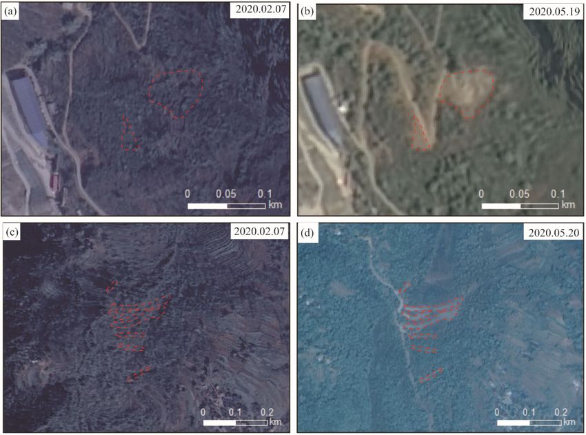
Landslides Triggered by the 2020 Qiaojia Mw5.1 Earthquake, Yunnan, China 1059
some polygons according the shapes of landslides. area of the landslides is only 1.81×10⁵ m2. According to the re-
The elevation in the study area was classified into 8 grades lation between the volume and area of landslides (V=1.314
with a spacing of 500 m. Slope angle was classified into 6 grades 7×A1.208 5, Xu et al., 2016), the total landslides volume was esti-
with a spacing of 10°. Slope aspect was classified into 9 grades. mated to be 2.97×10⁶ m3. The largest landslide is 8 345.17 m2.
Specially, the flat area is horizontal with a zero slope (Jenness et There are 102 landslides with an area less than 1 000 m2. The
al., 2013). Slope curvature, which means the amount that slope LND and LAP of this study region are 0.013 km-2 and 0.12%,
is curved, was divided into 6 classes. There were eight ages of respectively. Figure 4 shows some landslide interpretation cases
strata in the study area, i.e., Quaternary, Neogene, Permian, De- by comparing post- and pre-earthquake satellite images. These
vonian, Silurian, Ordovician, Cambrian, and Sinian. Because the results imply majority of the landslides are small- and medium-
XBF is closest to the epicenter, with a 5-km linear distance, ver- scale rockfalls and debris slides.
tical distance to the XBF and parallel distance along the XBF
were considered as influencing factors with an interval of 2 km, 3.2 Correlation between Landslide Distribution and Influ-
to examine their correlations with the landslide distribution. Ad- ence Factors
ditionally, when examining the effect of the 2014 Ludian earth- We show the correlation of landslides spatial distribution
quake, we chose not only Qiaojia earthquake intensity and the and various factors by LND and LAP. Using above two indexes,
distance to the Qiaojia epicenter, but also Ludian earthquake in- the distribution pattern of the landslides triggered by the 2020
tensity as seismic factors. The buffers were established around Qiaojia event were characterized by statistics with aforemen-
the epicenter with a 2 km interval. tioned influence factors.
The correlations of these factors with the distribution of the
coseismic landslides were examined. Furthermore, we identified 3.2.1 Topographic factors
the most influential factors and inferred the probable seismo- The elevation in the study area ranges from 513 to 4 026 m.
genic fault and the relationship between the Ludian earthquake The peaks of LAP and LND both appear in the range of 1 000–
and Qiaojia earthquake through statistical analysis based on In- 1 500 m with values of 0.038% and 0.3 km-2, respectively (Figs.
tersect Function in ArcGIS. 5a, 5b). There are ~33% of the total landslides occurred within
~13% of areas with elevations of 1 000 to 1 500 m in the study
3 RESULTS area. The values of LND in the ranges of 4 000 m are
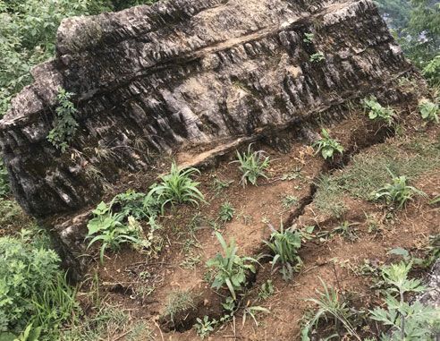
tioned, which damaged houses (Figs. 2a, 2b) and blocked roads smaller further. The curvilinear tend of LAP is generally con-
(Figs. 2c, 2d). All the debris slides occurred on steep slopes sistent with that of LND for the elevation factor (Fig. 5b).
along rivers and roads (Figs. 2e, 2f). Under the strong ground The slope angle ranges 0–76.7°, and the areas of each
motion, many imminent falling rocks with ruptures appeared on class decrease with increase of the slope angle in the study
hillslopes (Figs. 2g, 2h), threating the safety at the foot of the area. The LAP has generally positive correlations with the
mountain. slope angles, while the LND firstly increases with the growing
Combining field investigations with visual interpretation of slope angle and then decreases from 50°–60° (Figs. 5c, 5d).
satellite images, we eventually prepared an inventory with 167 The range with slope angles greater than 60° has the largest
coseismic landslides for the 2020 Qiaojia earthquake. They were LAP and the smallest LND, which is attributed to individual
distributed in a region of ~1 410 km2 (Fig. 3). The total occupied large landslides.
(a) (b) (c) (d)
(e) (f) (g) (h)
Figure 2. Pictures showing landslide hazards during 2020 Qiaojia earthquake. (a) and (b) damaged houses by rockfalls; (c) and (d) blocked roads by rockfalls;
(e) and (f) debris slides; (g) and (h) imminent falling rocks with ruptures.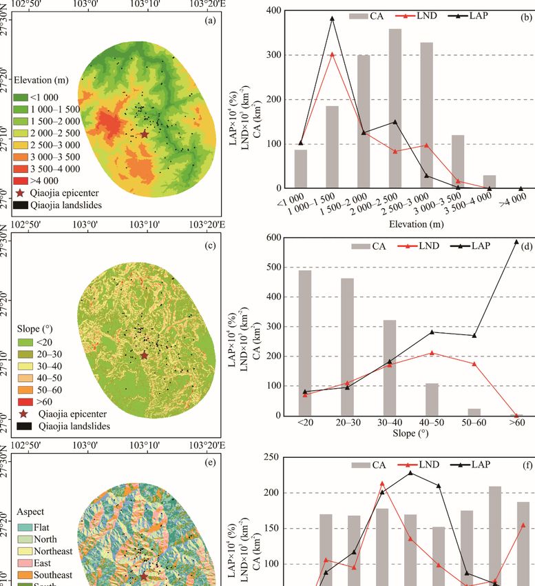
1060                  Xiangli He, Chong Xu, Wenwen Qi, Yuandong Huang, Jia Cheng, Xiwei Xu, Qi Yao, Yongkun Lu and Boyang Dai

                       Figure 3. Map showing study area (dashed ellipse) and distribution of landslides by the 2020 Qiaojia earthquake.

Figure 4. Two representative cases of landslides from interpretation by comparing post- and pre-earthquake satellite images. Pre-earthquake ones were acquired
on February 7, 2020, and post-earthquake ones on May 19 or 20, 2020. Red dotted lines show identified landslides.
Landslides Triggered by the 2020 Qiaojia Mw5.1 Earthquake, Yunnan, China                                                                                   1061

Figure 5. The landslide distribution in classifications of topographical factors (left) and their correlations (right) described by LAP and LND. LAP. Landslide
area percentage; LND. landslide number density; CA. classification area.
1062                   Xiangli He, Chong Xu, Wenwen Qi, Yuandong Huang, Jia Cheng, Xiwei Xu, Qi Yao, Yongkun Lu and Boyang Dai

      The area of each class of the slope aspect is relatively mean,                   slightly larger. The larger LAP in the range of >2 of the curva-
except the flat aspect that is almost nothing. The peak of LND is                      ture is due to individual landslides with relatively large area. It
on the east-facing slopes, followed by that on the southeast- and                      seems that there is almost no correlation between landslide dis-
northwest-facing slopes, while the LAP on the south-, southeast-                       tribution and slope curvature.
and east-facing slopes are obviously larger than other aspects
(Figs. 5e, 5f). It means that the scales of landslides on south-                       3.2.2 Geologic factors
facing slopes are relatively larger than those on northwest-facing                           As shown in Figs. 6a and 6b, the Permian strata dominated
slopes.                                                                                by limestone and basalt take up the largest area in the study area,
      Slope curvature is also a topographic factor affecting the                       with few landslides The LND and LAP both are relatively larger
distribution of landslides. Negative curvature indicates a con-                        in Ordovician and Cambrian strata (Figs. 6a, 6b), the lithologies
cave slope and positive curvature indicates a convex slope. A                          of which are characterized by more dolomite and shale with silt-
slope, with zero or near zero curvature, is a straight plane. As                       stone. However, it is hard to clarify whether this is due to differ-
shown in Figs. 5g, 5h, most of the slopes are on straight slopes.                      ent lithologies, because other strata also contain dolomite and
The LAP and LND in the range of -2– -1 of the curvature are                            siltstone.

Figure 6. Landslide distribution in categories of geological factors (left) and their correlations (right). (a) and (b) stratum; (c) and (d) vertical distance from the
Xiaohe-Baogunao fault (XBF); (e) and (f) parallel distance along the Xiaohe-Baogunao fault (XBF). LAP. Landslide area percentage; LND. landslide number
density; CA. classification area.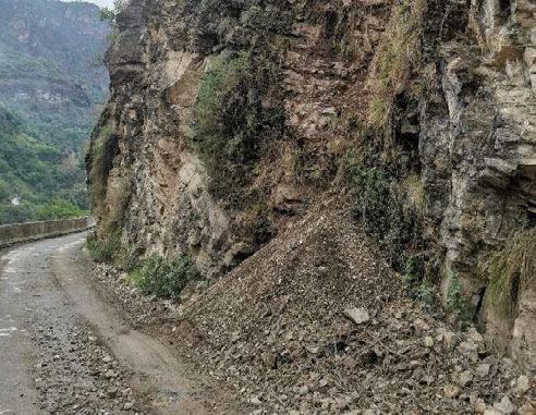
Landslides Triggered by the 2020 Qiaojia Mw5.1 Earthquake, Yunnan, China                                                                                        1063

     Figures 6c and 6d show the landslide distribution in the                          landslides generally decrease as the distance from the epicenter
bands parallel to the Xiaohe-Baogunao fault (XBF) (location                            increases. The LND and LAP shapely increase in the largest
shown in Fig. 3). Obviously, the landslides concentrate on both                        distance, which may attributed to the stress concentration effect
sides of the fault. The LAP and LND generally decrease as the                          at fault ends, or because of the small classification area in sta-
vertical distance to the fault increases, though there are some                        tistics.
small fluctuations. Their peaks occur in the band with distance
less than 2 km from the fault, with values of 0.51 km-2 and                            3.2.3    Seismic factors
0.057%, respectively.                                                                        Figures 7a and 7b show the most landslides occurred within
     The LAP and LND in the strips vertical to the XBF are                             2–8 km to the epicenter instead of the proximity area. Particu-
displayed in Figs. 6e, 6f, which indicate the landslide distribu-                      larly, the range of 4–6 km to the epicenter has the largest LAP
tion varies along the fault. The most of landslides are present in                     and LND values. From the distance of 6 km, the scale and num-
the strips close to the epicenter (within 6 km) and the peaks of                       ber of landslides generally decrease as the distance from the ep-
LND and LAP are in the band within distance 2–4 km to the                              icenter increases, while the values in the range of 0–2 km to the
epicenter. From the distance of 4 km, the scale and number of                          epicenter are smaller than those in the range of 8–10 km.

Figure 7. Landslide distribution in categories of seismic factors (left) and their correlations (right). (a) and (b) distance from the epicenter of Qiaojia earthquake;
(c) and (d) intensity of Qiaojia earthquake area; (e) and (f) Ludian earthquake intensity. LAP. Landslide area percentage; LND. landslide number density; CA.
classification area.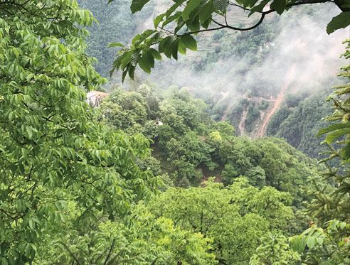
1064                Xiangli He, Chong Xu, Wenwen Qi, Yuandong Huang, Jia Cheng, Xiwei Xu, Qi Yao, Yongkun Lu and Boyang Dai

     Apparently, the scale and number of landslides in the VI           earthquakes are likely to occur on secondary or small faults, and
degree zone of the Qiaojia earthquake intensity are dominant,           usually cannot produce surface ruptures visible. Second, prelim-
although the area of the V degree zone is obviously larger than         inary positioning of the aftershocks of such earthquakes is often
that of the VI degree zone (Figs. 7c, 7d). In the study area, the       scattered, easy to blur the direction of rupturing. And third, the
classification areas decrease with increase of the Ludian earth-        signal-to-noise ratio of medium-sized earthquakes at teleseismic
quake intensity, while the LND and LAP in the VII degree zone           distances is low, thus difficult to distinguish the rupture direction.
of the Ludian earthquake intensity are slightly larger than other             For the 2020 Mw5.1 Qiaojia earthquake, the strike, dip, and
zones (Figs. 7e, 7f).                                                   rake of the two nodal planes are 170°/70°/-10° and 263°/81°/-
                                                                        160°, respectively, according to focal mechanism solutions from
4 DISCUSSION                                                            China Earthquake Networks. The seismic intensity map of this
4.1 Influence Factors of Landslide Occurrence                           event released by the Yunnan Seismological Bureau shows el-
      In this work, the distribution pattern of the landslides in-      liptical isoseismal lines with a long axis striking SSE160° (Fig.
duced by the 2020 Qiaojia earthquake was characterized con-             3). Zhao et al. (2020) used the horizontal peak ground accelera-
cerning varieties of influence factors. Among topographical fac-        tion (PGA) values recorded by stations near Qiaojia to perform
tors, most landslides occurred in the regions with elevations of        geometric averaging, yielding horizontal PGA contours spread-
1 000 to 1 500 m (Figs. 5a, 5b), but these areas have no distinc-       ing in the NW-SE direction. The peak acceleration reduces as the
tive features that can affect the occurrence of landslides. The         distance to the epicenter increases, of which variation tendency
LAP and LND seem to increase with the increasing slope angles,          has a strong similarity to the trend of the seismic intensity map
which is likely attributed to that the area of each grade reduces       prepared by the Yunnan Seismological Bureau. Li et al. (2020)
with increase of the slope angle (Figs. 5c, 5d). It is clear that       showed that the aftershock distribution within 24 h after the
there is almost no correlation between landslide distribution and       mainshock of the Qiaojia event has a long axis in SSE175°,
slope curvature (Figs. 5g, 5h). Uniquely, the number or scale of        which largely accords with the SSE nodal plane in the focal
landslides on E-, SE-, and S-facing slopes is relatively larger         mechanism solutions and the long axis direction of the seismic
(Figs. 5e, 5f), which probably resulted from the effect of previ-       intensity contours. With these constraints, it is inferred that
ous earthquakes (this will be discussed in section 4.3).                source rupture of the Qiaojia earthquake should be the nodal
      For geological factors, according to variations of the LAP        plane (stroke 170°, dip angle 70°, slip angle -10°) with sinistral
and LND in different strata and the detail of stratigraphic lithol-     strike-slip. Among the faults around the epicenter of the 2020
ogy (Figs. 6a, 6b), it is hard to see the relationship of lithology     Qiaojia Mw5.1 earthquake, the XBF is the closest, with a straight
and landslides occurrence. However, it is obvious that the              distance of only 5 km, which trends in NW. According to the 1 :
Xiaohe-Baogunao fault is closely related to landslide occur-            200 000 regional geological map of the Ludian Sheet, the fault
rence; the landslides concentrate on two sides of the fault (Figs.      trace is not continuous, and there are many secondary echelon
6c and 6d) and the number and scale generally decrease from the         faults with an acute angle on two sides of the main fault zone,
epicenter to fault ends (Figs. 6e, 6f).                                 and the motion of the XBF is mainly sinistral strike-slip (Cheng
      For seismic factors, the landslides are mainly distributed        et al., 2015; Xu et al., 2015).
near the epicenter (Figs. 7a, 7b) and within the zone of maximum              Superposing the magnitude and the distribution area of
seismic intensity of the Qiaojia earthquake (Figs. 7c, 7d). What        landslides for the Qiaojia earthquake on the map showing corre-
calls for special attention is the correlation between the 2014         lation between the distribution area of coseismic landslides with
Ludian earthquake intensity and landslide occurrence; most              the magnitude (Xu et al., 2014b), we found that the distribution
landslides are in the VII degree intensity zone of the 2014 Ludian      area of the Qiaojia coseismic landslides is larger than that of the
earthquake (Figs. 7c, 7d), where the damages are relatively seri-       events with same magnitude, while the 2014 Ludian earthquake
ous by the Ludian and Qiaojia earthquakes.                              is within the envelope (Fig. 8a). From the diagram showing the
                                                                        correlation between the magnitude and the number of coseismic
4.2    Seismogenic Fault of the Qiaojia Earthquake                      landslides (Alfaro et al., 2012; Keefer, 2002), the number of the
      There are many methods to infer seismogenic faults, each          Qiaojia coseismic landslides is greater than that of the earth-
has its own advantages and disadvantages. In seismic moment             quakes with same magnitude, while the Ludian earthquake are
tensor inversion, two possible fault planes (nodal planes) corre-       close to the fitted line (Fig. 8b). Combining the results of field
sponding to the best double couple can be obtained, but it is dif-      investigations and remote sensing interpretation, it is clear that
ficult to confirm which one is the real seismogenic fault. While        the Qiaojia earthquake landslides are large in number, small in
it is possible to confirm the seismogenic fault according to the        scale, and distributed in a large area, and the overall distribution
waveform residuals from inversion based on trying two couple            is in the NW-SE direction (Fig. 3). Based on the analysis of the
nodal planes one by one (Zhang Y et al., 2014). In general, the         correlation between the landslide distribution and fault factors
seismogenic fault can be identified by combination of focal             of this earthquake (Figs. 6b, 6c, 6e and 6f), the landslides mainly
mechanism solutions, aftershock distribution, and seismic rup-          occurred symmetrically along both sides of the XBF, decreasing
tures on the surface. Such an approach is suitable for large earth-     with the increasing distance from the fault, and gradually de-
quakes because of the clear fault parameters, obvious band-like         crease along the fault from the epicenter to both ends of the fault.
distribution of aftershocks, and the large rupture length (Zhang        Based on the aforementioned relationship between the seismo-
Y et al., 2014). In general, it is difficult to determine the seismo-   genic fault and coseismic landslides distribution, combined with
genic fault of medium-sized earthquakes. First, medium-sized            the nodal planes of focal mechanism, seismic intensity, PGA
Landslides Triggered by the 2020 Qiaojia Mw5.1 Earthquake, Yunnan, China                                                                                1065

Figure 8. The distribution area and number of landslides induced by 2020 Qiaojia earthquake compared with other events. (a) The relationship between the
earthquake magnitude and the landslides distribution area (modified from Xu et al., 2014b); (b) the correlation between the earthquake magnitude and the land-
slides number (modified from Alfaro et al., 2012).

contours, and the predominant direction of aftershocks, it is in-                 al., 2014), which accords with the 2020 Qiaojia earthquake.
ferred that the XBF has a close correlation with this earthquake.                 These imply that the 2020 Mw5.1 Qiaojia earthquake may be re-
However, considering the small difference among nodal planes                      lated to the 2014 Ludian Mw6.2 earthquake.
of the Qiaojia earthquake, the long axis trend of the isoseismal                        Xu et al. (2014b) used the elastic mid-space model (Okada,
line, the dominant earthquake sequence tendency and the main                      1992) and the coseismic kinematics data of the XBF to calculate
strike of the XBF, we suggest that the seismogenic structure of                   the Coulomb stress change at the depth of 10 km caused by the
the Qiaojia earthquake may be an echelon-shaped secondary and                     2014 Ludian earthquake. The results show that the increase of
buried fault branch of the XBF.                                                   static Coulomb stress is most obvious in an around 70% area
                                                                                  near the XBF, up to 70 kPa. Miao and Zhu (2016) obtained the
4.3 The Relationship between the Qiaojia Earthquake and                           similar results. Most of the aftershocks of the Ludian event are
Ludian Earthquake                                                                 in the region of increased Coulomb stress resulting from the
      The epicenter of the 2020 Mw5.1 Qiaojia earthquake is only                  main earthquake, implying the Ludian earthquake has a trigger-
20 km away from the 2014 Mw6.2 Ludian earthquake. The land-                       ing effect on the subsequent aftershocks (Fig. 9). According to
slides by the Qiaojia event are all within the VI–VIII degree                     previous work, the 2014 Ludian earthquake expanded from the
zones of the Ludian earthquake intensity, mostly in the VII zone.
The focal mechanism solutions of the Ludian event (Chen et al.,
2020b; Xie et al, 2015; Zhang G W et al., 2014) show a nodal
plane with 162°/70°/-14° (according to Global GMT), which is
similar to that of the Qiaojia earthquake (170°/70°/-10°). The Qi-
aojia earthquake landslides are largely distributed on the SE- and
E-facing slopes and the scales of the landslides on the S- and SE-
facing slopes are relatively large (Figs. 5c, 5g). The slopes facing
these directions may be affected by the 2014 Ludian earthquake
in the southeast. Additionally, all of the Qiaojia earthquake land-
slides happened in the region with the intensity greater than six
degrees of the seismic intensity of the Ludian earthquake; par-
ticularly in the VII intensity zone (Figs. 7e, 7f), where the dam-
ages were probably maximally superimposed by the Ludian and
Qiaojia earthquakes. The strip-like distribution of aftershocks in
the N30°W direction, the long axis of intensity (IX) zone in
NNW-NW-direction, and seismic ruptures in the episeismic
zone suggest that the 2014 Ludian earthquake’s seismogenic
fault is also the NW-trending XBF (Cheng et al., 2015; Xu Z J
et al., 2015; Wang et al., 2014; Xu X W et al., 2014). The focal                  Figure 9. Map showing landslides triggered by 2020 Mw5.1 Qiaojia earth-
mechanism solutions indicate that the seismogenic fault of the                    quake, epicenters, seismogenic fault, and static Coulomb stress change and
Ludian event is dominated by sinistral strike-slip, with a small                  aftershock distribution of 2014 Mw6.2 Ludian earthquake (modified from
normal faulting component (Xu L S et al., 2014; Zhang G W et                      Miao and Zhu, 2016).
1066 Xiangli He, Chong Xu, Wenwen Qi, Yuandong Huang, Jia Cheng, Xiwei Xu, Qi Yao, Yongkun Lu and Boyang Dai
deep to the shallow crust in the SSE direction, and a seismic in the VI–VIII degree zones of intensity map of the 2014 Ludian
surface rupture appeared in the southeast of the XBF (Xu X W earthquake.
et al., 2014). The 2020 Qiaojia earthquake epicenter and the (3) Combining landslide distribution, the long axis of the
most of coseismic landslides are located in the north-central maximum intensity zone, aftershocks, PGA, and focal mecha-
section of the XBF where the static Coulomb stress has increased nism solutions, it is inferred that the seismogenic structure of the
significantly, which might result from the 2014 Ludian earth- 2020 Qiaojia earthquake is likely a secondary hidden structure
quake event (Fig. 9). The distribution direction of the Qiaojia of the Xiaohe-Baogunao fault (XBF). Under the regional seis-
earthquake-induced landslides is overall consistent with that of motectonic background, the 2020 Qiaojia earthquake may be the
aftershocks of the Ludian earthquake in SE-NW direction, while inheritance of the 2014 Ludian earthquake in stress release. The
the former seems to be the extension of the later development relatively serious geohazard by the Qiaojia event is probably as-
toward northwest (Fig. 9). sociated with the aftermath of the 2014 Ludian earthquake.
Both the 2014 Ludian and the 2020 Qiaojia earthquakes
happened in the southeast of the Qiangtang Block and the east ACKNOWLEDGMENTS
border of the Sichuan-Yunnan rhomb block, with the sinistral This work was supported by the National Natural Science
strike-slip XBF in the east of the XAZX fault zone. The XBF is Foundation of China (No. 42077259) and the National Institute
a secondary active fault near the main boundary fault zone of the of Natural Hazards, Ministry of Emergency Management of
Sichuan-Yunnan rhomb block, which has not been noticed be- China (No. ZDJ2019-31). We thank Shoubiao Zhu for providing
fore the earthquakes. These two events may indicate that the us an original view of Fig. 9. We wish to thank the associate
Sichuan-Yunnan rhomb block, especially the central Yunnan editors and two anonymous reviewers for their useful sugges-
sub-block, continuously moves to SE, leading to continuous ac- tions to improve the manuscript. The final publication is available
cumulation of elastic strain in the block boundary zones and their at Springer via https://doi.org/10.1007/s12583-021-1492-1.
vicinity. Because the scale of the secondary active faults is small,
and its earthquake-generating capacity is relatively weak, the REFERENCES CITED
earthquakes produced by them are often medium-sized. There- Alfaro, P., Delgado, J., García-Tortosa, F. J., et al., 2012. Widespread Land-
fore, although we cannot assert that the 2020 Mw5.1 Qiaojia slides Induced by the Mw5.1 Earthquake of 11 May 2011 in Lorca, SE
earthquake is an aftershock of the 2014 Mw6.2 Ludian earth- Spain. Engineering Geology, 137/138: 40–52.
quake, it can be inferred that the Qiaojia earthquake is the sub- https://doi.org/10.1016/j.enggeo.2012.04.002
sequent release of the stress accumulation after the 2014 Ludian Chang, Z. F., Chen, X. L., An, X. W., et al., 2016. Contributing Factors to the
earthquake under the background that the rhomb block keeps Failure of an Unusually Large Landslide Triggered by the 2014 Ludian,
moving towards SE. The reason why the landslide hazard in- Yunnan, China, Ms=6.5 Earthquake. Natural Hazards and Earth System
duced by the Qiaojia earthquake is more serious than others with Sciences, 16(2): 497–507. https://doi.org/10.5194/nhess-16-497-2016
the similar magnitude is probably due to the effect of the 2014 Chang, Z. F., Zhou, R. J., An, X. W., et al., 2014. Late-Quaternary Activity
Ludian earthquake on the stability of the slopes in this area. of the Zhaotong-Ludian Fault Zone and Its Tectonic Implication. Seis-
mology and Geology, 36(4): 1260–1279 (in Chinese with English Ab-
5 CONCLUSIONS stract)
Based on field investigations, visual interpretation of re- Chen, J. L., Zheng, Y., Zhang, L., et al., 2020b. Focal Mechanism Solutions
mote sensing images based on ArcGIS, a detailed inventory of of the 2014 Ludian Ms6.5 Earthquake Sequence Derived from Multiple-
the landslides induced by 2020 Mw5.1 Qiaojia, Yunnan China Bandwidth Waveform Fitting. Chinese Journal of Geophysics, 63(4):
earthquake was prepared. The correlation of spatial distribution 1472–1483 (in Chinese with English Abstract)
with possible influence factors involving topography, geology Chen, S., Miao, Z. L., Wu, L. X., et al., 2020. Application of an Incomplete
and seismology and tectonic significance of these landslides Landslide Inventory and One Class Classifier to Earthquake-Induced
were studied. The conclusions are as follows. Landslide Susceptibility Mapping. IEEE Journal of Selected Topics in
(1) In total, 167 coseismic landslides of the 2020 Qiaojia Applied Earth Observations and Remote Sensing, 13: 1649–1660.
earthquake were delineated, with a distribution area of ~1 410 https://doi.org/10.1109/JSTARS.2020.2985088
km2 and landslide-occupation area of 0.18 km2, respectively. Cheng, J., Wu, Z., Liu, J., et al., 2015. Preliminary Report on the 3 August
They are distributed in a relatively broad area, smaller on the 2014, Mw6.2/Ms6.5 Ludian, Yunnan-Sichuan Border, Southwest China,
scale for individuals and larger in the number compared to those Earthquake. Seismological Research Letters, 86(3): 750–763.
of other events with same magnitude. https://doi.org/10.1785/0220140208
(2) For topographical factors, the number and scale of land- Cui, Y. L., Bao, P. P., Xu, C., et al., 2021. Landslides Triggered by the 6
slides on S-, SE-, and E-facing slopes are relatively larger. For September 2018 Mw6.6 Hokkaido, Japan: An Updated Inventory and
geological factors, the correlation between faults and landslide Retrospective Hazard Assessment. Earth Science Informatics, 14(1):
occurrence is more significant than that between stratum lithol- 247–258. https://doi.org/10.1007/s12145-020-00544-8
ogy and landslide occurrence. The LAP and LND generally re- Dai, F. C., Tu, X. B., Xu, C., et al., 2011. Rock Avalanches Triggered by
duce with increasing vertical distance from the fault, and gradu- Oblique-Thrusting during the 12 May 2008 Ms8.0 Wenchuan Earthquake,
ally reduce from the epicenter to both ends of the Xiaohe- China. Geomorphology, 132(3/4): 300–318. https://doi.org/10.1016/j.ge-
Baogunao fault. For seismic factors, landslides are mostly con- omorph.2011.05.016
centrated near the epicenter and within the zone of maximum Deng, Q. D., Zhang, P. Z., Ran, Y. K., et al., 2003. Basic Characteristics of
seismic intensity. Meanwhile it is noted that all the landslides are Active Tectonics of China. Science in China Series D: Earth Sciences,Landslides Triggered by the 2020 Qiaojia Mw5.1 Earthquake, Yunnan, China 1067
46(4): 356–372. https://doi.org/10.1360/03yd9032 Parker, R. N., Densmore, A. L., Rosser, N. J., et al., 2011. Mass Wasting Trig-
Fan, X. M., Scaringi, G., Korup, O., et al., 2019. Earthquake-Induced Chains gered by the 2008 Wenchuan Earthquake is Greater than Orogenic Growth.
of Geologic Hazards: Patterns, Mechanisms, and Impacts. Reviews of Nature Geoscience, 4(7): 449–452. https://doi.org/10.1038/ngeo1154
Geophysics, 57(2): 421–503. https://doi.org/10.1029/2018rg000626 Ren, Z. K., Lin, A. M., Rao, G., 2010. Late Pleistocene-Holocene Activity of the
Gan, W. J., Zhang, P. Z., Shen, Z. K., et al., 2007. Present-Day Crustal Motion Zemuhe Fault on the Southeastern Margin of the Tibetan Plateau. Tectono-
within the Tibetan Plateau Inferred from GPS Measurements. Journal of physics, 495(3/4): 324–336. https://doi.org/10.1016/j.tecto.2010.09.039
Geophysical Research Solid Earth, 112: B08416 Shao, X. Y., Xu, C., Ma, S. Y., et al., 2019. Effects of Seismogenic Faults on
Geological and Mineral Bureau of Yunnan Province, 1990. Regional Geolog- the Predictive Mapping of Probability to Earthquake-Triggered Land-
ical Map of Yunnan Province. Geological Press, Beijing slides. ISPRS International Journal of Geo-Information, 8(8): 328.
Guzzetti, F., Mondini, A. C., Cardinali, M., et al., 2012. Landslide Inventory https://doi.org/10.3390/ijgi8080328
Maps: New Tools for an Old Problem. Earth-Science Reviews, 112(1/2): Shen, Z. K., Lü, J., Wang, M., et al., 2005. Contemporary Crustal Defor-
42–66. https://doi.org/10.1016/j.earscirev.2012.02.001 mation around the Southeast Borderland of the Tibetan Plateau. Journal
Han, Z., He, Y. L., An, Y. F., et al., 2009. A Newly Generated Seismotectonic of Geophysical Research: Solid Earth, 110(B11): B11409.
Zone—Preliminary Study on the Latest Tectonic Deformation of the https://doi.org/10.1029/2004jb003421
Mabian Earthquake Zone. Acta Geologica Sinica, 83(2): 218–229 (in Tian, Y. Y., Xu, C., Ma, S. Y., et al., 2019. Inventory and Spatial Distribution
Chinese with English Abstract) of Landslides Triggered by the 8th August 2017 Mw6.5 Jiuzhaigou
Harp, E. L., Jibson, R. W., 1995. Inventory of Landslides Triggered by the Earthquake, China. Journal of Earth Science, 30(1): 206–217.
1994 Northridge, California Earthquake. USGS. http://geo- https://doi.org/10.1007/s12583-018-0869-2
nsdi.er.usgs.gov/metadata/openfile/95-213/ Vanani, A. A. G., Shoaei, G., Zare, M., 2021. Statistical Analyses of Land-
Harp, E. L., Keefer, D. K., Sato, H. P., et al., 2011. Landslide Inventories: slide Size and Spatial Distribution Triggered by 1990 Rudbar-Manjil
The Essential Part of Seismic Landslide Hazard Analyses. Engineering (Mw7.3) Earthquake, Northern Iran: Revised Inventory, and Controlling
Geology, 122(1/2): 9–21. https://doi.org/10.1016/j.enggeo.2010.06.013 Factors. Bulletin of Engineering Geology and the Environment, 80(4):
He, H. L., Ikeda, Y., He, Y. L., et al., 2008. Newly-Generated Daliangshan 3381–3403. https://doi.org/10.1007/s10064-021-02106-8
Fault Zone—Shortcutting on the Central Section of Xianshuihe- Wang, E., Burchfiel, B. C., Royden, L. H., et al., 1998. Late Cenozoic
Xiaojiang Fault System. Science in China Series D: Earth Sciences, Xianshuihe-Xiaojiang, Red River, and Dali Fault Systems of Southwest-
51(9): 1248–1258. https://doi.org/10.1007/s11430-008-0094-4 ern Sichuan and Central Yunnan, China, Special Paper of the Geological
Jenness, J., Brost, B., Beier, P., 2013. Land Facet Corridor Designer: Exten- Society of America, 327: 1–108. https://doi.org/10.1130/0-8137-2327-
sion for ArcGIS. Jenness Enterprises. [2018-11-10]. http://www.jennes- 2.1
sent.com/arcgis/land_facets.htm Wang, W. L., Wu, J. P., Fang, L. H., et al. 2014. Double Difference Location
Kargel, J. S., Leonard, G. J., Shugar, D. H., et al., 2016. Geomorphic and of the Ludian Ms6.5 Earthquake Sequences in Yunnan Province in 2014.
Geologic Controls of Geohazards Induced by Nepals 2015 Gorkha Chinese Journal of Geophysics, 57(9): 3042–3051 (in Chinese with Eng-
Earthquake. Science, 351(6269): aac8353. https://doi.org/10.1126/sci- lish Abstract)
ence.aac8353 Wen, X. Z., Du, F., Yi, G. X., et al., 2013. Earthquake Potential of the
Keefer, D. K., 2002. Investigating Landslides Caused by Earthquakes––A Zhaotong and Lianfeng Fault Zones of the Eastern Sichuan-Yunnan Bor-
Historical Review. Surveys in Geophysics, 23(6): 473–510. der Region. Chinese Journal of Geophysics, 56(10): 3361–3372 (in Chi-
https://doi.org/10.1023/A:1021274710840 nese with English Abstract)
Khattak, G. A., Owen, L. A., Kamp, U., et al., 2010. Evolution of Earthquake- Wen, X. Z., Ma, S. L., Xu, X. W., et al., 2008. Historical Pattern and Behavior of
Triggered Landslides in the Kashmir Himalaya, Northern Pakistan. Ge- Earthquake Ruptures along the Eastern Boundary of the Sichuan-Yunnan
omorphology, 115(1/2): 102–108. https://doi.org/10.1016/j.geo- Faulted-Block, Southwestern China. Physics of the Earth and Planetary In-
morph.2009.09.035 teriors, 168(1/2): 16–36. https://doi.org/10.1016/j.pepi.2008.04.013
Li, W. T., Dang, W. J., Jin, M. P., et al., 2020. The Focal Mechanism Solution Wieczorek, G. F., 1984. Preparing a Detailed Landslide-Inventory Map for
and Seismogenic Fault of the 2020 Qiaojia Ms5.0 Earthquake in Yunnan. Hazard Evaluation and Reduction. Environmental & Engineering Geo-
Seismological and Geomagnetic Observation and Research, 41(3): 184– science, XXI(3): 337–342. https://doi.org/10.2113/gseegeosci.xxi.3.337
192 (in Chinese with English Abstract) Wu, C. H., Cui, P., Li, Y. S., et al., 2018. Seismogenic Fault and Topography
Liao, H. W., Lee, C. T., 2000. Landslides Triggered by the Chi-Chi Earth- Control on the Spatial Patterns of Landslides Triggered by the 2017 Jiu-
quake. In: Proceedings of the 21st Asian Conference on Remote Sensing, zhaigou Earthquake. Journal of Mountain Science, 15(4): 793–807.
Taipei. 1/2: 383–388 https://doi.org/10.1007/s11629-017-4761-9
Ma, B. Q., Su, G., Hou, Z. H., et al., 2005. Late Quaternary Slip Rate in the Xie, Z. J., Zheng, Y., Liu, C. L., et al., 2015. Source Parameters of the 2014
Central Part of the Longmenshan Fault Zone from Terrace Deformation Ms6.5 Ludian Earthquake Sequence and Their Implications on the Seis-
along the Minjiang River. Seismology and Geology, 27(2): 234–242 (in mogenic Structure. Seismological Research Letters, 86(6): 1614–1621.
Chinese with English Abstract) https://doi.org/10.1785/0220150085
Miao, M., Zhu, S. B., 2016. The Static Coulomb Stress Change of the 2014 Xu, C., 2015a. Preparation of Earthquake-Triggered Landslide Inventory
Ludian Earthquake and Its Influence on the Aftershocks and Surround- Maps Using Remote Sensing and GIS Technologies: Principles and Case
ing Faults. Seismology and Geology, 38(1): 169–181 (in Chinese with Studies. Geoscience Frontiers, 6(6): 825–836.
English Abstract) https://doi.org/10.1016/j.gsf.2014.03.004
Okada, Y., 1992. Internal Deformation Due to Shear and Tensile Faults in a Xu, C., 2015b. Utilizing Coseismic Landslides to Analyze the Source and
Half-Space. Bulletin of the Seismological Society of America, 82(2): Rupturing Process of the 2014 Ludian Earthquake. Journal of Engineer-
1018–1040 ing Geology, 23(4): 755–759 (in Chinese with English Abstract)1068 Xiangli He, Chong Xu, Wenwen Qi, Yuandong Huang, Jia Cheng, Xiwei Xu, Qi Yao, Yongkun Lu and Boyang Dai
Xu, C., Xu, X. W., 2014. The Spatial Distribution Pattern of Landslides Trig- China. Science in China Series D: Earth Sciences, 46(2): 210–226.
gered by the 20 April 2013 Lushan Earthquake of China and Its Impli- https://doi.org/10.1360/03dz0017
cation to Identification of the Seismogenic Fault. Chinese Science Bul- Xu, X. W., Xu, C., 2021. Natural Hazards Research: An Eternal Subject of
letin, 59(13): 1416–1424. https://doi.org/10.1007/s11434-014-0202-0 Human Survival and Development. Natural Hazards Research, 1(1): 1–
Xu, C., Xu, X. W., Yao, X., et al., 2014a. Three (Nearly) Complete Invento- 3. https://doi.org/10.1016/j.nhres.2020.12.003
ries of Landslides Triggered by the May 12, 2008 Wenchuan Mw7.9 Xu, X. W., Xu, C., Yu, G. H., et al., 2015. Primary Surface Ruptures of the Ludian
Earthquake of China and Their Spatial Distribution Statistical Analysis. Mw6.2 Earthquake, Southeastern Tibetan Plateau, China. Seismological Re-
Landslides, 11(3): 441–461. https://doi.org/10.1007/s10346-013-0404-6 search Letters, 86(6): 1622–1635. https://doi.org/10.1785/0220150038
Xu, C., Xu, X. W., Shen L. L., 2014b. Inventory of Landslides Triggered by Zhang, G. W., Lei, J. S., Liang, S. S., et al., 2014. Relocations and Focal
the 2014 Ms6. 5 Ludian Earthquake and Its Implications on Several Mechanism Solutions of the 3 August 2014 Ludian, Yunnan Ms6.5
Earthquake Parameters. Seismology and Geology, 36(4):1186–1203 (in Earthquake Sequence. Chinese Journal of Geophysics, 57(9): 3018–
Chinese with English Abstract) 3027 (in Chinese with English Abstract)
Xu, C., Xu, X. W., Tian, Y. Y., et al., 2016. Two Comparable Earthquakes Zhang, P. Z., Deng, Q. D., Zhang, G. M., et al., 2003. Active Tectonic Blocks
Produced Greatly Different Coseismic Landslides: The 2015 Gorkha, and Strong Earthquakes in the Continent of China. Science in China Se-
Nepal and 2008 Wenchuan, China Events. Journal of Earth Science, ries D: Earth Sciences, 46(2): 13–24. https://doi.org/10.1360/03dz0002
27(6): 1008–1015. https://doi.org/10.1007/s12583-016-0684-6 Zhang, S. C., Wang, S. J., Diao, G. L., et al., 1994. The Rupture Characteris-
Xu, J. X., Xu, C., He, X. L., et al., 2020. Spatial Distribution of Seismic Land- tics of 1974 Yongshan-Daguan Earthquake Sequence. Acta Geophysica
slides in the Areas of 1927 Gulang M8.0 Earthquake. Earthquake Re- Sinica, 170–176 (in Chinese with English Abstract)
search in China, 34(1): 5–28 (in Chinese with English Abstract) Zhang, Y., Xu, L. S., Chen, Y. T., et al., 2014. Rupture Process of the 3 Au-
Xu, L. S., Zhang, X., Yan, C., et al., 2014. Analysis of the Love Waves for gust 2014 Ludian, Yunnan, Mw6.1 (Ms6.5) Earthquake. Chinese Journal
the Source Complexity of the Ludian M(s)6.5 Earthquake. Chinese Jour- of Geophysics, 57(9): 3052–3059 (in Chinese with English Abstract)
nal of Geophysics, 57(9): 3006–3017 (in Chinese with English Abstract) Zhao, K., Lin, G. L., Yang, L., et al., 2020. Strong Motion Record Analysis
Xu, X. W., Jiang, G. Y., Yu, G. H., et al., 2014. Discussion on Seismogenic of the Qiaojia Ms5.0 Earthquake in Yunnan Province. Seismological and
Fault of the Ludian Ms6.5 Earthquake and Its Tectonic Attribution. Chi- Geomagnetic Observation and Research, 41(3): 200–208 (in Chinese
nese Journal of Geophysics, 57(9): 3060–3068 (in Chinese with English with English Abstract)
Abstract) Zhu, C. N., Chen, C. Z., 1976. The Rupture Mechanism of the Zhaotong
Xu, X. W., Wen, X. Z., Zheng, R. Z., et al., 2003. Pattern of Latest Tectonic Earthquake of 1974 in Yunnan Province. Chinese Journal of Sinica,
Motion and Its Dynamics for Active Blocks in Sichuan-Yunnan Region, 19(4): 317–329 (in Chinese with English Abstract)You can also read