Little Aston Neighbourhood Plan, 2015-2029 - Made 19th April 2016 - Lichfield District Council
←
→
Page content transcription
If your browser does not render page correctly, please read the page content below

Little Aston Neighbourhood Plan,
2015-2029

Made 19th April 2016
Little Aston Neighbourhood Plan
Little Aston Neighbourhood Plan

CONTENTS

1     INTRODUCTION .................................................................................... 1

2     LOCAL CONTEXT .................................................................................... 4
      History of Little Aston............................................................................................ 4
      Profile of the community ....................................................................................... 6
      Local infrastructure ..............................................................................................12
      Local Plan policy ..................................................................................................13

3     VISION ................................................................................................ 14
      Challenges for Little Aston ....................................................................................14
      Vision for Little Aston ...........................................................................................14

4     GREEN BELT ........................................................................................ 16

5     CANNOCK CHASE SPECIAL AREA OF CONSERVATION ....................... 18

6     HOUSING ............................................................................................. 19
      Residential infill and backland development ...........................................................19

7     LITTLE ASTON PARK ........................................................................... 22
      Density of development in Little Aston Park ...........................................................22
      Design ................................................................................................................23

8     MOVEMENT .......................................................................................... 25
      Walking and cycling .............................................................................................25
      Public transport ...................................................................................................26
      Pedestrian safety .................................................................................................27

9     COMMUNITY HUB................................................................................ 28

10    BROADBAND INFRASTRUCTURE......................................................... 30

11    LIGHT POLLUTION .............................................................................. 31

12    NON-LAND USE ACTIONS ................................................................... 32
      Extension to the Conservation Area .......................................................................32
      Signage ..............................................................................................................32

PROPOSALS MAP ........................................................................................ 33
Little Aston Neighbourhood Plan
Little Aston Neighbourhood Plan

1     INTRODUCTION
1.1   This document represents the Neighbourhood Plan for Little Aston. It represents one part of the
      development plan for the neighbourhood area over the period 2015 to 2029, the other part being
      the 2015 Lichfield District Local Plan.
1.2   Lichfield District Council, as the local planning authority, designated the Little Aston Neighbourhood
      Area in February 2013 to enable Shenstone Parish Council to prepare the Neighbourhood Plan.
      The Plan has been prepared by the community through the Little Aston Neighbourhood Plan (LANP)
      Group.

1.3   The LANP is being prepared in accordance with the Town & Country Planning Act 1990, the
      Planning & Compulsory Purchase Act 2004, the Localism Act 2011 and the Neighbourhood Planning
      Regulations 2012. The LANP Group has prepared the plan to establish a vision for the future of
      the neighbourhood area and to set out how that vision will be realised through planning and
      controlling land use and development change over the plan period 2015 to 2029.
1.4   The map below shows the boundary of the Neighbourhood Plan area.

                                                                                                          1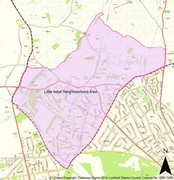
Little Aston Neighbourhood Plan

1.5   The purpose of the Neighbourhood Plan is to guide development and provide guidance to any
      interested parties wishing to submit planning applications for development within the designated
      Neighbourhood Area. The process of producing a plan has sought to involve the community as
      widely as possible and the different topic areas are reflective of matters that are of considerable
      importance to Little Aston, its residents, businesses and community groups. It has therefore given
      the community the opportunity to guide development within their neighbourhood.
1.6   Each section of the plan covers a different topic. Under each heading there is the justification for
      the policies presented which provides the necessary understanding of the policy and what it is
      seeking to achieve. The policies themselves are presented in the blue boxes. It is these policies
      against which planning applications will be assessed. It is advisable that, in order to understand
      the full context for any individual policy, it is read in conjunction with the supporting text.

      National and local policy
1.7   The National Planning Policy Framework (NPPF) states:
              “Neighbourhood planning gives communities direct power to develop a
              shared vision for their neighbourhood and deliver the sustainable
              development they need. Parishes … can use neighbourhood planning to set
              planning policies through neighbourhood plans to determine decisions on
              planning applications (para.183).

              Neighbourhood planning provides a powerful set of tools for local people to
              ensure that they get the right types of development for their community.
              The ambition of the neighbourhood should be aligned with the strategic
              needs and priorities of the wider local area.

              Neighbourhood plans must be in general conformity with the strategic
              policies of the Local Plan. To facilitate this, local planning authorities should
              set out clearly their strategic policies for the area and ensure that an up-to-
              date Local Plan is in place as quickly as possible. Neighbourhood plans
              should reflect these policies and neighbourhoods should plan positively to
              support them. Neighbourhood plans and orders should not promote less
              development than set out in the Local Plan or undermine its strategic
              policies (para.184).

              Outside these strategic elements, neighbourhood plans will be able to shape
              and direct sustainable development in their area. Once a neighbourhood
              plan has demonstrated its general conformity with the strategic policies of
              the Local Plan and is brought into force, the policies it contains take
              precedence over existing non-strategic policies in the Local Plan for that
              neighbourhood, where they are in conflict. Local planning authorities should
              avoid duplicating planning processes for non-strategic policies where a
              neighbourhood plan is in preparation (para.185)”.

1.8   The relevant Lichfield District Local Plan was adopted in February 2015 and covers the period to
      2029. It has provided the strategic context for the neighbourhood plan.

                                                                                                         2
Little Aston Neighbourhood Plan
Consultation
1.9 The LANP Group has developed the Neighbourhood Plan through extensive engagement with the
community. Working Parties were set up to focus on particular issues and themes.
1.10 Four engagement events were held:
A launch event in April 2013 to introduce the Neighbourhood Plan and understand the issues
– following this event the Working Groups were formed.
An engagement event in September 2013 to present the key issues emerging from the Working
Groups and to seek feedback on these.
A survey was undertaken in January 2014 which had responses from over 40% of households
and in March 2014 an engagement event was held to present the findings of the survey work
and to explore options for the Neighbourhood Plan.
An engagement event in September 2014 to present the draft Neighbourhood plan and to
seek feedback on this.
1.11 Additional consultations were undertaken throughout the process by the Working Groups with key
stakeholders.
3
Little Aston Neighbourhood Plan

 2    LOCAL CONTEXT

      History of Little Aston
2.1   Little Aston has a long history that has shaped the community today.
2.2   In Roman days, Ryknild Street cut through the heart of Little Aston to link up with Watling St near
      Wall. It gives its name to Roman Road that runs through the Little Aston Park Estate.
2.3   The links with Shenstone and Stonnall can be traced back to the Domesday Book with the
      settlement of Aston mentioned with Footherley and Woodend alongside Stonnall and Lynn
      Chesterfield within the parish of Shenstone. From 1774 onwards, with later Tithe and Enclosure
      maps, it is easier to track the development of the settlements and see the history of Little Aston
      unfold.
2.4   These maps showed various mills in Shenstone Parish with a significant mill at Little Aston on Mill
      Lane, on the River Bourne. It was a corn mill and a lease in 1830 showed it was owned by William
      Leigh. In 1838 a later Tithe Map shows Shenstone Parish comprising of 8,452 acres with William
      Leigh of Little Aston owning 2,590 acres (of which the hall and park amounted to 770 acres). The
      hall mentioned is Little Aston Hall that was built in 1730 in a Georgian style with a park and a lake.
2.5   The 1774 map also shows Little Aston Forge in Forge Lane downstream on the River Bourne from
      Little Aston Mill. There are records of a lease dated 1600 from Roger Fowke, Lord of the Manor of
      Little Aston, to a Philip Foley and that it produced over 100 tons of bar iron a year selling most of
      the output to the West Bromwich slitting mill. The forge went out of use in 1749 when converted
      to a mill. The last remains of the forge were destroyed by fire in 1902 and the area is now the
      location for a sewage works.

2.6   In 1818 when the Enclosure Act came into force, large areas of Little Aston Common adjoining
      Sutton Park were assigned to William Tennant, the then owner of Little Aston Park, which doubled
      the size of the estate. The estate was sold in 1828 to William Leigh who kept it until 1844 when it
      was sold to Edward Jervis. The hall was restyled and enlarged in 1857 (at a reputed cost of
      £35,000) and looked very much like the picture below taken in 1986.
      Figure 2.1: Little Aston Hall

                                                                                                          4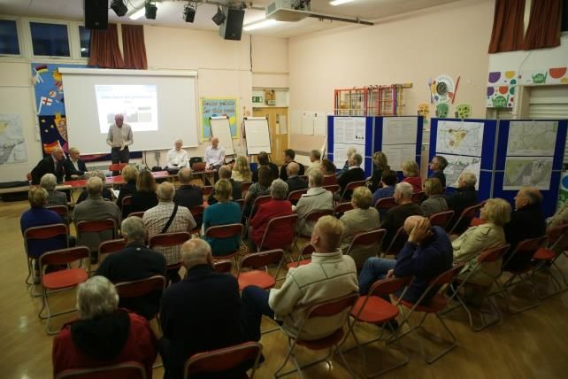
Little Aston Neighbourhood Plan

2.7    Little Aston became a separate ecclesiastical parish within Shenstone on consecration of St. Peters
       Church in 1874, with the church being built at the expense of Edward Jervis on land donated by
       him.
2.8    The Hall passed through various owners in the early 1900s until in 1925 the Little Aston Hall estate
       of over 1,500 acres was broken up, with the Hall and 118 acres surrounding it purchased by a
       Harry Scribbans and the remaining land sold piecemeal by auction leading to the current Little
       Aston Park estate as we now know it.
2.9    The Hall was lived in until 1949 and remained unoccupied from 1950 until 1954 when it became
       the Midlands HQ of Esso. From 1968 it served as a residential centre for GKN. In 1984 the site was
       developed, the hall converted into superior residential apartments and seven new blocks each of
       six apartments built in the grounds overlooking the lake. Further blocks of apartments, a residential
       care home and the private hospital have since followed.

2.10   Much of the rest of the Little Aston of today stems from 1910 onwards as shown on the map in
       Figure 2.2.
       Figure 2.2: Evolution of development in Little Aston

       Source: Lichfield District Council

                                                                                                          5
Little Aston Neighbourhood Plan

       Profile of the community
2.11   Unless stated otherwise, the profile of the community has come from the 2011 Census.

       Population
2.12   In 2011, the population of the ward was 2,920. Compared to Lichfield District, it has a high
       proportion of older people - 27% were aged 65 or over in Little Aston compared to 20% across
       the district (see Figure 2.3).
       Figure 2.3: Population profile, 2011

                81+

               65-80

               45-64

               30-44

               19-29                                                 West Midlands
         Age

               17-18                                                 Lichfield
                                                                     Little Aston
               11-16

                4-10

                 0-3

                       0%    5% 10% 15% 20% 25% 30% 35%
                                  % of population

       Source: 2011 Census

2.13   Since 2001, the population of the parish has only grown by 90 persons, a 3.2% change compared
       to 8.0% growth across Lichfield District as a whole. This is reflective of the restrictions on growth
       in Little Aston due to the presence of the green belt. What is particularly interesting is the change
       in population by age group.

                                                                                                            6
Little Aston Neighbourhood Plan
Figure 2.4: Change in population, 2001-2011
81+
65-80
45-64
30-44
Age
19-29 West Midlands
Lichfield
17-18
Little Aston
11-16
4-10
0-3
-2% 0% 2% 4% 6%
% change in population
Source: 2011 Census
2.14 Little Aston experienced very strong growth in its retirement population (aged 65 and older) whilst
also experiencing a decline in much of its population of working age (aged 30 to 64). This
demonstrates not only an ageing population structure but also a declining workforce, although this
was partially offset by the increase in people of young working age (age 19 to 29). This is shown
in Figure 2.4).
Work
2.15 What is noticeable about Little Aston’s population of working age (16 to 74) is that it has a
comparatively low proportion of people in full-time employment. Those that are economically
inactive are comparatively high, reinforcing the high number of retirees in the ward.
2.16 What Little Aston does have a strong representation in is self-employed people, both with and
without employees. This demonstrates that there is a strong entrepreneurial aspect to the working
population.
2.17 This is shown in Figure 2.5.
7Little Aston Neighbourhood Plan
Figure 2.5: Economic activity, 2011
Economically Inactive; Total
Full-Time Student
Unemployed
Self-employed without employees - total
Self-employed with employees - total
Employee; Full-Time
Employee; Part-Time
0% 5% 10% 15% 20% 25% 30% 35% 40%
All usual residents aged 16-74
West Midlands Lichfield Little Aston
Source: 2011 Census
2.18 Little Aston is comparatively strongly represented in two very different sectors. The first is the
professional, scientific and technical sector, which shows that Little Aston has a high proportion of
people working in a number of highly skilled professions. The second is retail and repair which is
comparatively lower skilled. Similarly it is well represented in the service sector which encompasses
a range of different skills and professions.
2.19 This is shown in Figure 2.6.
8Little Aston Neighbourhood Plan
Figure 2.6: Type of industry, 2011
Source: 2011 Census
2.20 Figure 2.7 reinforces this, showing that 40% of the population is educated to Level 4 or above,
i.e. degree level. By contrast, the proportion of those with no qualifications is well below the district
average.
Figure 2.7: Qualifications of residents aged 16 and over
Other Qualifications
Level 4 Qualifications and Above
Level 3 Qualifications
Apprenticeship
Level 2 Qualifications
Level 1 Qualifications
No Qualifications
0% 5% 10% 15% 20% 25% 30% 35% 40%
% of residents aged 16+
West Midlands Lichfield Little Aston
Source: 2011 Census
9Little Aston Neighbourhood Plan
2.21 The large majority of those in work travel to work by car, and do so as the driver of that car. Whilst
there are both rail and bus links serving the area, there is only one bus route and this does not
link to Blake Street station, with the station itself being some distance from the main residential
areas of Little Aston. As such, it is not surprising that the proportion of those who use the train or
bus is lower than the district average.
2.22 The high levels of car usage are supported by Census figures on access to a car within households.
On average, each Little Aston household has access to 2.1 cars. This compares to 1.5 cars per
household in Lichfield district and 1.2 cars per household across the West Midlands. This represents
very high levels of car ownership.
2.23 A significant proportion of people (7%) work from home, which supports the high proportion of
self-employment amongst those of working age.
2.24 This is shown in Figure 2.8.
Figure 2.8: Mode of transport to work
50%
45%
40%
35%
% of workforce
30%
25%
Little Aston
20%
Lichfield
15%
10% West Midlands
5%
0%
Source: 2011 Census
Housing
2.25 Little Aston is dominated by detached housing, representing nearly 70% of its housing stock. By
contrast, the proportion of semi-detached and terraced housing is very low. The bulk of flatted
development is mostly found in Lady Aston Park, within the Little Aston Park area.
2.26 This is shown in Figure 2.9.
10Little Aston Neighbourhood Plan
Figure 2.9: Type of dwelling
80%
70%
60%
% of dwellings
50%
40%
Little Aston
30%
Lichfield
20%
West Midlands
10%
0%
Source: 2011 Census
2.27 This is reinforced when looking at the number of bedrooms that properties in Little Aston have.
Figure 2.10 shows that it has a far higher proportion of both 4- and 5+ bed properties than the
district or across the West Midlands as a whole. By contrast, the proportion of 1-3-bed properties
is much lower.
Figure 2.10: Number of bedrooms
50%
45%
40%
35% No Bedrooms
% of dwelligs
30% 1 Bedroom
25% 2 Bedrooms
20% 3 Bedrooms
4 Bedrooms
15%
5 or More Bedrooms
10%
5%
0%
Little Aston Lichfield West Midlands
Source: 2011 Census
2.28 The ownership profile of these dwellings reinforces the profile of Little Aston as an affluent area.
Figure 2.11 shows that a very high proportion of people own their property – in excess of 90%.
By contrast, the equivalent proportion in Lichfield is just 75%. In fact, 56% of the properties in
11Little Aston Neighbourhood Plan
Little Aston are owned outright with no mortgage on them, compared to just 39% across the
district.
Figure 2.11: Ownership profile
100%
90%
80%
70%
% of dwellings
60%
50%
40%
30%
20%
10%
0%
Owned Social Rented Private Rented
Little Aston Lichfield West Midlands
Source: 2011 Census
2.29 By contrast, Little Aston has a very low proportion of social rented housing stock; just 1% of the
stock compared to 13% across the district as a whole.
Local infrastructure
Education
2.30 There is only one school in the neighbourhood area, Little Aston Primary School. Figures from the
Department of Education suggest that the school is close to capacity, however it is not thought
that this has reached a critical situation and, given the expected levels of growth, is not likely to
become a critical issue over the lifetime of the plan.
2.31 All secondary education is provided outside the neighbourhood area. There is a local school bus
that picks up in Little Aston to take pupils into Lichfield. There are other local secondary schools
in the neighbouring boroughs of Birmingham and Walsall.
Healthcare
2.32 There are no doctors’ surgeries in Little Aston nor have there been any for the last 20 years. Most
people are registered with practices in Birmingham. However, feedback from the community has
not suggested access to a GP practice to be a problem. This is despite the fact that there have
been instances recently of Birmingham practices de-registering Staffordshire residents as part of
their list reconciliations1.
2.33 There is one dental surgery in Little Aston. There is also the private Spire Little Aston Hospital that
has 37 private beds and also provides some NHS treatments on behalf of Good Hope Hospital,
Sutton Coldfield, which is the major hospital for Shenstone Parish and all surrounding areas.
1
Lichfield District Strategic Partnership (2012) Enhanced joint strategic needs assessment for Lichfield District
12Little Aston Neighbourhood Plan
Public Transport
2.34 There is only one bus route (Sutton Coldfield to Aldridge/Walsall) that passes through Little Aston.
2.35 The main Lichfield-to-Birmingham cross-city rail line stops at Blake Street rail station on the
extremity of Little Aston, across the border in Birmingham. There is free car parking at the station
but insufficient car parking spaces to meet peak demands.
Walking and Cycling
2.36 There are no cycle paths at present in the neighbourhood area. There are two public footpaths
that pass through Little Aston - one that cuts across Little Aston golf course to the Chester Road
and one that starts by the old forge in Forge Lane, running along the line of Ryknild Street to the
Birmingham Road at Shenstone Wood End.
Road Networks
2.37 Throughout the Neighbourhood Plan process, traffic has been a major issue for the community.
Concerns have been expressed at speeding traffic and at the high number of heavy goods vehicles
(HGVs) using the A4026 (Blake Street/Little Aston Lane) as a ‘rat run’.
2.38 The particular concerns of the community are:
Speeding traffic along Blake Street, Little Aston Lane and Aldridge Road along with the high
number of HGV’s using this route as a rat run.
The situation of Mill Lane as a derestricted road having no footpaths being used by fast moving
traffic despite restricted visibility, bends and a new housing development.
The junction at Little Aston Park Road and Hardwick Road being impeded by a fence that
restricts visibility for cars pulling out.
The entrance/exit from Little Aston Hospital being on the crest of a rise.
The need for a pedestrian crossing at the Blake Street traffic lights as well as a possible
crossing near Blake Street Station.
Local Plan policy
2.39 The 2015 Lichfield District Local Plan covers the period to 2029. It identifies Little Aston as a ‘rural
settlement’ and recognises that such settlements should be able to “adapt to accommodate their
future needs and to become more locally sustainable without compromising the character of their
village and its surrounding environment” (paragraph 17.93). Where a neighbourhood plan can
identify and justify small scale growth that is desired and needed by the local community, then
this will be permitted. This is reflected in Policy Rural 2 (‘Other Rural Settlements’).
2.40 Part of the neighbourhood area is within the green belt. Core Policy 1 (‘The Spatial Strategy’) of
the District Local Plan states that:
“Changes to Green Belt boundaries that do not have a fundamental impact
on the overall strategy may be appropriate for all settlements within the
Green Belt, with the precise boundaries of these changes being determined
through the Local Plan Allocations document.”
2.41 This provides the opportunity for the Neighbourhood Plan to suggest potential revisions to the
green belt boundary, subject to these complying with the requirements of the NPPF. These will
then be considered through the Local Plan process.
13Little Aston Neighbourhood Plan
3 VISION
Challenges for Little Aston
3.1 The Neighbourhood Plan seeks to address, as far as is possible, the challenges that face the
community of Little Aston neighbourhood area. In summary these challenges are:
An ageing population that has particular demands in terms of their accessibility to services.
A declining population of working age, with many unable to afford the high house prices which
are partly a function of the stock of large, detached properties.
Maintaining Little Aston’s identity as a distinct community that its residents enjoy living in.
Ensuring that development (particularly infill and backland development) maintains the
character and density of the surrounding built form.
Addressing the problems caused by its busy, sometimes urban roads, particularly pedestrian
safety and severance.
Vision for Little Aston
3.2 At the first public engagement event, the community was asked ‘What will a future Little Aston
feel like?’ A range of words were presented as options for people to choose from. Out of this list
of words, the most commonly used were:
‘Rural’
‘Quiet’
‘Exclusive’
‘Distinctive’
3.3 It is evident that the community wishes for Little Aston to stay very much as it is today. Given this,
the vision for Little Aston at the end of the plan period (in 2029) is as follows:
‘By the end of the plan period in 2029, Little Aston will be much as it is today, an
attractive, affluent suburb with high quality housing and a pleasant, leafy
environment. Any new housing will have been restricted to infill developments and be
of a similar density and character to neighbouring properties. Claverdon Park will have
been incorporated into the Little Aston Conservation Area.
Plans for a Community Hub on the land to the North of Little Aston Lane have been
developed and funding identified from a variety of local and national sources to allow
development to proceed, incorporating new community facilities and spaces. This
provides the community with a focal point whilst protecting the rural edge of Little
Aston from unwanted development.
Whilst traffic flows continue to be extremely heavy throughout the neighbourhood
area, crossing to reach the shops and Blake Street railway station has been made
easier for pedestrians. Rat running and speeding traffic, both major threats to
pedestrian, equestrian and cycle safety, have been reduced through the provision of
effective traffic calming measures, a common speed limit throughout the
neighbourhood area, effective enforcement and technological advances.
14Little Aston Neighbourhood Plan
Meanwhile, improvements have been made to the network of pedestrian and cycle
paths, both for access and leisure. A circular cycling/walking/jogging/horse-riding
route encompassing Forge Lane/Mill Lane/Aldridge Road has been developed and is
well used for recreational purposes, steps having been taken to minimise traffic flows
and speeds along the rural lanes.’
15Little Aston Neighbourhood Plan
4 GREEN BELT
4.1 Part of the Little Aston neighbourhood area is within the green belt which wraps closely around its
western and northern boundary. The green belt has safeguarded the built-up area of Little Aston
from the kind of sprawl seen elsewhere within the district and has contained development within
the parkland setting or established street pattern.
4.2 It has, in the main, been successful in achieving the five main purposes of the green belt, as
provided by the National Planning Policy Framework (NPPF):
To check the unrestricted sprawl of large built-up areas;
To prevent neighbouring towns merging into one another;
To assist in safeguarding the countryside from encroachment;
To preserve the setting and special character of historic towns;
To assist in urban regeneration by encouraging the recycling of derelict and other urban land.
4.3 The NPPF makes clear that the Government attaches great importance to green belts and these
should only be altered in exceptional circumstances as part of the review of a local plan.
4.4 Core Policy 1 (‘The Spatial Strategy’) of the Lichfield District Local Plan states that:
“Changes to Green Belt boundaries that do not have a fundamental impact
on the overall strategy may be appropriate for all settlements within the
Green Belt, with the precise boundaries of these changes being determined
through the Local Plan Allocations document.”
4.5 This provides the opportunity for the Neighbourhood Plan to recommend potential revisions to the
green belt boundary, subject to these complying with the requirements of the NPPF. These will
then be considered through the Local Plan process.
4.6 Engagement with the community has demonstrated that protection of the existing green belt
boundary is one of the most important ways in which Little Aston can protect its identity and
function as a community. There is therefore no desire to see the Green Belt boundary be altered
to any significant degree and the community considers its long term protection is important to
preserve the character of the village and maintain the separation from neighbouring settlements
(e.g. Shenstone Woodend and Aldridge).
4.7 Land north of Little Aston Lane, alongside the Church, south of Little Aston Road/Walsall Road and
to the west of Little Aston Park should therefore remain within the Green Belt. These areas perform
a key role in meeting the five purposes of Green Belt and there is no reason to release those areas
from the Green Belt designation.
4.8 The one location within Little Aston that is considered suitable and appropriate to amend the Green
Belt boundary is at Tufton Cottage, Roman Road.
4.9 Tufton Cottage is located to the south of Beech Gate, a private, gated driveway set behind the
Grade II listed Beech Gate.
4.10 The Green Belt boundary is drawn along Beech Gate and includes a single dwelling, Tufton Cottage,
within its boundary. Tufton Cottage clearly forms part of the street scene of Roman Road and thus
part of the built environment. It is separated from the wider Green Belt by dense woodland and
has strong, defensible boundaries. Having regard to paragraph 85 of the NPPF, the retention of
Tufton Cottage within the Green Belt is considered unnecessary in order for the five purposes of
16Little Aston Neighbourhood Plan
Green Belt to be maintained. Removing Tufton Cottage from the Green Belt would clearly
distinguish the suburban environment of Little Aston Park from the more open countryside beyond
and make right an existing anomaly.
4.11 The community therefore considers that it would be appropriate for Tufton Cottage to be brought
within the settlement boundary and omitted from the Green Belt. The Green Belt should
consequently be re-drawn to exclude Tufton Cottage, retaining the adjacent golf course wholly
within the Green Belt. In doing so, it is considered that the five purposes of Green Belt are
maintained. The precise boundaries that the Neighbourhood Plan recommends should be revised
are shown on the Proposals Map. Consideration of this recommended change will then be made
through the Local Plan process.
4.12 To further secure the character of the Conservation Area and the setting of the adjacent Grade II
listed Beech Gate, it is considered that the plot should be included within the policy on density of
development within Little Aston Park. This is addressed in Policy LAP1.
POLICY GB1: GREEN BELT BOUNDARY
In accordance with Core Policy 1 of the Lichfield District Local Plan, it is proposed that the green
belt boundary should be amended to exclude Tufton Cottage, Roman Road. This should be
undertaken through the Lichfield Local Plan Site Allocations process.
17Little Aston Neighbourhood Plan
5 CANNOCK CHASE SPECIAL AREA OF CONSERVATION
5.1 Part of the designated Neighbourhood Plan area is within 15 kilometres of the Cannock Chase
Special Area of Conservation (SAC). This is a nationally important designation which reflects the
considerable ecological value of the area and the need to protect it. Development within the 15km
radius could increase the number of people wanting to visit the SAC area and therefore potentially
have a detrimental impact on the sensitive ecological network.
5.2 It is therefore necessary to have a policy which recognises that all development must be capable
of demonstrating that it will not have a detrimental impact.
POLICY SAC1: CANNOCK CHASE SPECIAL AREA OF CONSERVATION
Before development is permitted it must be demonstrated that alone or in combination with other
development it will not have an adverse effect whether direct or indirect upon the integrity of the
Cannock Chase Special Area of Conservation (SAC) having regard to avoidance or mitigation
measures.
In particular, any development that results in a net increase in dwellings within a 15km radius of
any boundary of Cannock Chase SAC will be deemed to have an adverse impact upon the Cannock
Chase SAC unless or until satisfactory avoidance and/or mitigation measures have been secured.
18Little Aston Neighbourhood Plan
6 HOUSING
Residential infill and backland development
6.1 Backland development is defined as development on land behind the rear building line of existing
housing or other development, and is usually land that has previously been used as gardens, or is
partially enclosed by gardens.
6.2 Infill development involves the development of a small gap in an otherwise built up frontage. It
usually consists of frontage plots only and often comprises side gardens of existing houses.
Policy Justification
6.3 One of the particular issues raised by the community of Little Aston has been the over-bearing
nature of some infill and backland developments. With the presence of the green belt across much
of the neighbourhood area, new housing is predominantly to come through infill development.
Moreover, with the density policy covering Little Aston Park (see Policy LAP1), the issue arises
most acutely in the built-up areas within the remainder of the neighbourhood area. In the past
there have been some infill and backland developments which have been permitted at very high
densities, creating issues in terms of amenity for neighbouring properties. Adverse impacts can
include the following:
Loss of amenity, overshadowing, overlooking
Loss of sunlight/daylight
Noise
Loss of green links/trees/hedgerows/vegetation
Visual intrusion
Loss of space between buildings
Loss of parking
Single long driveways serving multiple properties2
Difficulties with recycling and waste collections/bin storage
6.4 Paragraph 53 of the NPPF states that:
“Local planning authorities should consider the case for setting out policies
to resist inappropriate development of residential gardens, for example
where development would cause harm to the local area.”
6.5 It is considered important that infill and backland development, whilst generally acceptable within
the built-up area, must be designed so that it sits appropriately within its surroundings. It is
acknowledged that, if development is of a different mix of housing, e.g. 2- and 3-bed dwellings in
a predominantly 4- and 5-bed dwelling area, then densities may differ slightly. However, it is vital
that the design of such developments does not have a negative impact on the amenity of existing
residents in the neighbouring properties. In particular, it should be ensured that such properties
have reasonably sized gardens, based on the size of the property.
6.6 The objectives of this policy are to ensure that:
2
This has been observed on development in Little Aston Lane
19Little Aston Neighbourhood Plan
infill development respects and reflects the character of the area and the existing street scene;
backland development respects and reflects the character of the area;
safe and attractive residential layouts are promoted; and
local distinctiveness and identity are promoted.
6.7 The particular issues that must be considered in demonstrating that an infill or backland scheme
is acceptable are as follows:
6.8 Plot width – plots must be of sufficient width to allow building(s) to be sited with adequate
separation between dwellings. The width of the remaining and the new plot should be similar to
that prevailing in the immediate area.
6.9 Building line – where the prevailing depth of existing dwellings is a feature of the area new
development should respect that building line.
6.10 Visual separation – new dwellings must have similar spacing between buildings to that
commonly found on the street frontage. Where houses are terraced the new development should
normally adjoin the adjacent property(s).
6.11 Building height – new buildings should reflect the height of existing buildings. Where existing
buildings are of a uniform height, new buildings should respect that height.
6.12 Daylight and sunlight – new buildings should not adversely affect neighbouring properties by
seriously reducing the amount of daylight available through windows or by obstructing the path of
direct sunlight to a once sunny garden or window. Blocking direct sunlight from reaching
neighbouring properties can cause overshadowing and is not acceptable.
6.13 Parking and access arrangements – satisfactory arrangements will be required for parking
and access. Generally parking areas to the front of the property using the front garden will not be
acceptable unless, this is the prevailing pattern of parking in the locality.
6.14 Boundary treatment – boundary treatment along the frontage should reflect that prevailing in
the area. Proposals for open frontages or the use of the frontage for parking will not be acceptable
in areas where enclosed front boundaries prevail.
20Little Aston Neighbourhood Plan
Policy
POLICY HSG1: RESIDENTIAL INFILL AND BACKLAND DEVELOPMENT
Outside of the Little Aston Park density policy area, as shown on the Proposals Map, planning
permission for residential development proposals on infill and backland sites will be permitted
subject to the following criteria:
Proposals should reflect the character of the surrounding area and protect the amenity of
neighbours. It should reinforce the uniformity of the street by reflecting the scale, mass, height
and form of its neighbours.
Proposals that would lead to over-development of a site or the appearance of cramming will
be resisted. It should be demonstrated that development is of a similar density to properties
in the immediate surrounding area.
New buildings should not adversely affect neighbouring properties by seriously reducing the
amount of daylight available through windows or by obstructing the path of direct sunlight to
a once sunny garden or window.
Development must not unacceptably reduce the level of private amenity space provision for
existing residential properties.
This policy also applies to applications for two or more properties on a site previously occupied by
a single property.
21Little Aston Neighbourhood Plan
7 LITTLE ASTON PARK
7.1 With Little Aston Park being such a unique place within the wider Little Aston area as it meets the
built-up area of Sutton Coldfield, it is considered important that its particular assets are maintained
and enhanced. The Proposals Map shows the full extent of the entire Little Aston settlement area;
the area of Little Aston Park extends to most of the density policy area, but does not have its own
formal policy boundary.
Density of development in Little Aston Park
Policy Justification
7.2 The special character of Little Aston Park is determined by the extensive mature tree cover and
low density and individual design of dwellings in large plots. It represents a high quality
environment.
7.3 In recognition of this, the 1998 Lichfield Local Plan included Policy SA.6 in respect of Little Aston
Park. Specifically this policy sought to protect the special character of the area by requiring all new
dwellings to be accommodated within plots of at least half an acre. Saved Policy SA.6 was to be
considered through the Local Plan Allocations process, however, the community of Little Aston has
made it clear that it considers the policy should continue to apply and as such be addressed
through the Neighbourhood Plan.
7.4 The Little Aston Rural Masterplanning Report 3 stated at paragraph 105 that:
“This policy has been successful in retaining the ‘leafy character’ valued by
most residents and its removal could in the longer term significantly erode
that character. It is considered therefore that it is essential to retain the
policy.”
3
Lichfield District Council (2011) Lichfield District Rural Planning Project: Little Aston
22Little Aston Neighbourhood Plan
7.5 It is therefore considered important that the policy is retained within the Neighbourhood Plan to
ensure that the existing character of the area is retained and in particular that the tree canopy of
the area, which is important both from local and more distant viewpoints, is maintained.
Policy
POLICY LAP1: DENSITY OF DEVELOPMENT IN LITTLE ASTON PARK
The special character of Little Aston Park is determined by the extensive mature tree cover and
low density and individual design of dwellings in large plots.
Development in the Density Policy area defined on the Proposals Map will only be allowed where
the special character of the area is protected by the retention of all existing important established
and mature trees and vegetation and by the provision of a rustic and pastoral setting for new and
existing dwellings.
All new and existing dwellings within subdivided plots must be accommodated within plots of at
least half an acre (excluding long driveways) and retain the existing relationship of dwellings to
the woodland setting.
7.6 It should be noted that, as identified in the Green Belt chapter and in policy GB1 (Green Belt
boundary), it is proposed that there should be an amendment to the green belt boundary to
exclude Tufton Cottage, Roman Road, to be considered through the Local Plan Allocations process.
Once this amendment has been made through the Lichfield Local Plan Site Allocations process,
this land should be included within the Density Policy area as shown on the Proposals Map. This
will help to further secure the character of the Conservation Area and the setting of the adjacent
Grade II listed Beech Gate.
Design
Policy Justification
7.7 The nature of Little Aston Park as it has developed over a number of decades is for properties to
be very large and detached, set down long driveways with significant screening and landscaping
between neighbouring properties. The properties themselves, outside of their size, do not show a
significant degree of uniformity, instead showing a range of styles and architectural features.
7.8 There are some members of the community, particularly within Little Aston Park, that wish to
demonstrate innovation in architecture of new properties. This does not have to mean styles that
23Little Aston Neighbourhood Plan
are wholly not in keeping with the surrounding properties but developments that show off some
of the best features of modern architecture within what is a rural, leafy setting.
7.9 The opportunity for new or replacement properties to demonstrate innovative design is therefore
encouraged. This must not be in such a way that it has a detrimental impact on the appearance
of Little Aston Park, particularly if it is not well screened from neighbouring properties. However,
the use of different designs and materials will be encouraged.
Policy
POLICY LAP2: DESIGN OF DEVELOPMENT IN LITTLE ASTON PARK
Development proposals for new or replacement dwellings in the Little Aston Park density policy
area (Policy LAP1) that show innovative design will be encouraged.
Such design should ensure that the residential amenity of neighbouring properties is not impacted
and that the extensive mature tree cover making up Little Aston Park’s woodland setting is
retained.
The design of new dwellings must comply with the requirements of Policy LAP1.
The
24Little Aston Neighbourhood Plan
8 MOVEMENT
Walking and cycling
Policy Justification
8.1 The community has identified the need to improve pedestrian and cycle networks as important for
Little Aston. The current dominance of the car (as shown in Figure 2.8) has resulted in significant
safety concerns for those travelling on foot or by bicycle. This is both in terms of day-to-day access
to school, work, services and public transport links but also for those wishing to walk/run or cycle
for leisure purposes.
8.2 There is a specific scheme that has been identified by the community that will serve to improve
access for pedestrians and cyclists, both for access and leisure. This is the creation of a circular
cycle/jogging/walking route along Forge Lane/Mill Lane/Aldridge Road – this will provide a
dedicated route for exercise totalling five kilometres in distance. It will also improve access into
the countryside for residents of the built-up area of Little Aston.
Figure 8.1: Circular cycling/jogging/walking route
NB – Amended Figure 8.1 to reflect Modification 4 - The Key to figure 8.1 replace ‘Ward Boundary’
with ‘Neighbourhood Plan Area’. Also reflects LDC recommended modification to key to replace
‘Route outside the ward boundary’ to ‘Route outside Neighbourhood Plan Area’.
8.3 As shown in Figure 8.1, part of this route is outside the neighbourhood area boundary, it is shown
for illustrative purposes only and is not affected by any part of this plan. However, the Parish
25Little Aston Neighbourhood Plan
Council – which has jurisdiction over the area covering the whole route - is committed to working
with landowner partners to deliver any improvements. In addition, Stonnall ward where the route
runs has provided support for the scheme, albeit that it is not included in the Stonnall
Neighbourhood Plan.
8.4 The provision of this link is likely to require funding to provide the necessary physical improvements
for improved safety and ease if vulnerable road users. It is unlikely that the entire route will be
capable of being provided away from car traffic. In these areas, signage (both on the roadside and
on the road itself), or other acceptable measures, should be used to alert motorists to the presence
of pedestrians and cyclists.
8.5 Funding will need to come from a number of sources. These include grants from organisations
such as the Heritage Lottery Fund, through the Local Transport Plan and other funding streams
available through Staffordshire County Council (as the highways authority) and through developer
contributions.
Policy
POLICY MOV1: PROVISION OF FOOTPATHS AND CYCLEPATHS
Proposals to provide dedicated footpaths and cyclepaths, and signage to alert motorists to the
presence of pedestrians and cyclists along particular routes will be encouraged.
In particular, the provision of a circular cycle/jogging/walking route along Forge Lane/Mill
Lane/Aldridge Road will be supported in order to provide improvements for access and leisure
purposes.
Public transport
Policy Justification
8.6 Many people identified the fact that public transport services for Little Aston were poor. In
particular, access to Blake Street Station from Little Aston is limited by public transport.
8.7 The improvement of bus services is a costly exercise and the limited levels of growth expected in
Little Aston do not provide a mechanism to secure the levels of funding needed to expand routes
or the frequency of existing services.
8.8 However, the specific need for a new bus stop on the north side of Aldridge Road, to serve Little
Aston Hospital, was identified. This will help to improve access to the Hospital.
8.9 Any developer contributions will be used to fund the provision of a bus stop incorporating a full
bus shelter at this location.
Policy
POLICY MOV2: PROVISION OF NEW BUS STOPS
Proposals to provide new bus stops and shelters along existing bus routes will be supported. In
particular, the provision of a new bus stop on the north side of Aldridge Road will be strongly
supported.
The
26Little Aston Neighbourhood Plan
Pedestrian safety
8.10 Throughout the Neighbourhood Plan process, traffic has been a major issue for the community.
The specific issues of concern were identified in Section 2. Any solutions will obviously enhance
pedestrian safety along the main roads identified.
8.11 Shenstone Parish Council is very aware of these concerns and had already contributed to specific
traffic surveys undertaken by Staffordshire County Council Highways Department at selected ‘hot
spots’.
8.12 The results of these surveys were made available in September 2014 at a meeting of the Action
Staffordshire Group. This is a Group recently created that consists of all the Parish Council
chairpersons from the Lichfield Rural South Division together with District Councillors and
interested individual representatives of groups (including any Neighbourhood Plan teams) for
better communication on common issues and will tackle traffic issues across the whole area.
8.13 Concerns have been expressed at speeding traffic and at the high number of heavy goods vehicles
(HGVs) using the A4026 (Blake Street/Little Aston Lane) as a ‘rat run’.
8.14 Additionally the Community would like to see an improved crossing at the traffic lights at the Blake
St, Rosemary Hill/Clarence Road/Little Aston Lane junction. At peak times with traffic turning in all
directions there is no break in the traffic light sequence to enable pedestrians (particularly those
with young children/pushchairs or dogs) to cross safely. A simple All Red sequence would achieve
this. This will be pursued via Action Staffordshire.
8.15 Furthermore the Community would like a pedestrian crossing across Blake Street opposite Station
Approach. The footpath along Blake Street is only on one side of the road so everyone has to cross
here over the busy road that is 40mph at this point. This would require improvements outside the
neighbourhood plan area.
8.16 Action Staffordshire has a £30,000 budget from the Staffordshire County Council Highways Fund
to deliver small and medium schemes over the period to 2016 and it will be up to the individual
communities to prioritise with Action Staffordshire what is done and where and what is possible.
8.17 Action Staffordshire has acknowledged the Little Aston Park Road/Hardwick Road/Burnett Road
junction as a priority issue and is actively looking at a solution.
POLICY MOV3: PROVISION OF PEDESTRIAN SAFETY IMPROVEMENTS
Proposals to address issues of pedestrian safety that are of concern to the community will be
supported.
Proposals which are likely to create unacceptable safety issues for pedestrian movement will be
refused.
The
27Little Aston Neighbourhood Plan
9 COMMUNITY HUB
9.1 A Community Hub is seen as highly desirable in terms of providing a physical location to act as a
heart of the community. The preferred location is along the north side of Little Aston Lane, which
would also serve to protect the rural edge of Little Aston from development that is out of keeping
with the area that represents the link between the built-up and rural parts of the neighbourhood
area.
9.2 Suggestions of possible uses at a Community Hub have included:
a cricket pitch and nets;
a pitch-and-putt golf course;
a new Community Hall;
a skateboard park;
hard courts for netball, volleyball and basketball; and
extensions to the current highly-successful Recreation Ground.
Policy Justification
9.3 This represents an important aspiration for Little Aston. However, at the present time, the
preferred location for such a facility, on the north side of Little Aston Lane, has not been secured.
There will need to be ongoing negotiations with current landowners. If this is not successful then
alternative locations will be considered although work on the Neighbourhood Plan has not identified
any alternatives that are appropriate to provide a hub for the community in an easily accessible
location.
9.4 Whilst a location is being identified, further work is required to identify and secure the necessary
funding.
9.5 Meanwhile, subject to sufficient local support, drive and commitment, a Working Group involving
all interested parties (e.g. Shenstone Parish Council, Little Aston Village Hall, Little Aston
Recreation Ground, etc) should be set up to:
canvass local opinion on the nature and scale of such a development;
draw up plans based on this research; and
seek out sources of funding to allow development to proceed.
9.6 It may be appropriate to secure such provision through the use of a Community Right to Build
Order.
9.7 Any proposals which either create the opportunity to provide for such needs or potentially
jeopardise this opportunity will be considered within the light of the aspiration for such provision
at this location.
9.8 It should be noted that if a community hub building can be secured on the north side of Little
Aston Lane, then its location in the Green Belt means that ‘exceptional circumstances’ must be
proven, unless its use is as a facility for outdoor sport or outdoor recreation (NPPF paragraph 89).
A community hall is unlikely to fit that description.
28Little Aston Neighbourhood Plan
Policy
POLICY CMH1: PROVISION OF COMMUNITY HUB
Proposals which directly provide or assist in the provision of a community hub on land north of
Little Aston Lane, shall be supported.
In accordance with national green belt policy and Core Policy 1 of the Local Plan Strategy any
proposals must ensure that:
the uses proposed do not conflict with the purposes of green belt land; and
the openness of the green belt is preserved.
In respect of preserving the openness of the green belt, it must be ensured that any building is
not excessive in scale and height and is designed in a way that minimises its visual impact. Unless
the building is to provide appropriate facilities for outdoor sport or outdoor recreation then
exceptional circumstances must be proven for its location in the green belt, in line with national
planning policy.
Such proposals will be expected to demonstrate how they have engaged with any working group
or equivalent that has been set up in Little Aston to ascertain what facilities should be provided as
part of any such community hub.
Proposals for the development of a community hub at an alternative location will be considered
favourably if they are in a location that is generally accessible by foot and within or adjacent to
the built-up area of Little Aston.
The provision
29Little Aston Neighbourhood Plan
10 BROADBAND INFRASTRUCTURE
10.1 The modern economy is changing and increasingly needs good communications infrastructure as
a basic requirement. The 2011 Census highlights how people are working differently to a
generation ago - in Little Aston ward, 7% of people work from home and 18% are self-employed.
Of these self-employed people, 8% have no employees so effectively work for themselves with no
support. Commonly this is in service activities that simply require access to a computer and a
broadband connection.
10.2 The need for high speed broadband to serve Little Aston is therefore paramount. Broadband
speeds are reported by residents to be poor and it is therefore a fundamental constraint to the
continuing expansion of self-employed activity for those working from home or from a small office.
10.3 Government has recognised that there is a significant gap in availability of basic and superfast
broadband, particularly in rural areas where British Telecom (BT) and other national providers
have not invested in upgrades to the network and have allocated £530m through the Broadband
Delivery UK (BDUK) programme to deliver superfast broadband to 90% of premises by 2015 and
have recently allocated an additional £250m to increase coverage to 95% of premises by 2017
and 99% by 2018.
10.4 In Staffordshire, Superfast Staffordshire is working on a roll-out programme to bring fibre-based
broadband to 90% of premises by Spring 2016.
10.5 Whilst BT has an obligation to provide a landline to every household in the UK and developers are
expected to want to facilitate high speed broadband provision otherwise their developments will
be substantially less marketable, there have been instances where developers have not contacted
Next Generation Access (NGA) Network providers early enough in the process for fibre and ducting
to be laid, or they have a national agreement with a cable provider that is not active in the area,
leaving new housing developments with little or no connections.
10.6 Policy BBD1 seeks to ensure that all new housing, community and commercial development in the
neighbourhood area is connected to superfast broadband.
POLICY BBD1: HIGH SPEED BROADBAND
It is expected that all new properties should be served by a superfast broadband (fibre optic)
connection. The only exception will be where it can be demonstrated, through consultation with
NGA Network providers, that this would not be either possible, practical or economically viable. In
such circumstances sufficient and suitable ducting should be provided within the site and to the
property to facilitate ease of installation at a future date.
30Little Aston Neighbourhood Plan
11 LIGHT POLLUTION
11.1 One of the identified issues in the Little Aston neighbourhood area is light pollution. In a relatively
rural location, where the topography makes certain parts of the neighbourhood area highly visible,
poorly designed and located lighting can have a disproportionate polluting effect.
11.2 The Little Aston Neighbourhood Plan recognises the guidance notes on the reduction of light
pollution provided by the Institute of Lighting Engineers 4. This guidance should be followed in
seeking to comply with Policy EE1. Specifically, any development away from the built up area
should accord with the guidance Environmental Zone E2 which covers appropriate lighting in rural
or small village locations; within the built-up area it should accord with the guidance Environmental
Zone E3 which covers appropriate lighting in small town centres or urban locations.
11.3 It will be a requirement of any form of development which proposes external lighting to minimise
the amount of light that is visible from outside the property. Lighting in public areas, particularly
street lights, should be provided in the form of downlighters which serve to minimise the amount
of light that is visible away from the area of the street intended to be lit.
POLICY EE1: LIGHT POLLUTION
New development will be required to demonstrate how it has minimised light pollution created
through its proposed use.
Where lighting of public places is proposed, the use of downlighters will be required.
There will be a presumption against development which will still create high levels of light pollution
even after the above criteria have been addressed.
4
Institute of Lighting Engineers (2000) Guidance Notes for the Reduction of Light Pollution
31You can also read