Local Biodiversity Study - City of Kwinana
←
→
Page content transcription
If your browser does not render page correctly, please read the page content below
D19/18265

Local Biodiversity Study
D19/18265

Table of Contents

1.0 Introduction
2.0 Importance of Biodiversity
  2.1    Biodiversity - why is it important?
  2.2    Values and Benefits of Protecting Biodiversity
3.0     Planning and Legislative Framework
  3.1    Federal Government
  3.2    State Government
  3.3    Regional Planning
  3.4    Local Government
4.0 Biodiversity and Conservation Areas Profile
  4.1    Distribution of Areas having Biodiversity Values
  4.2    Vegetation component
  4.3    Other Biodiversity Feature components
5.0 Results of Investigation – Baseline Data
6.0 Threats to City’s Biodiversity and Conservation Areas
  6.1    Vegetation Clearing causing Habitat Loss, Degradation, and Fragmentation
  6.2    Erosion
  6.3    Inappropriate Fire Regimes
  6.4    Changed Water Regimes and/or Water Quality
  6.5    Inappropriate Human Use
  6.6    Diseases/weeds/pest animals
  6.7    Urbanisation
  6.8    Government policy and economic disincentives
  6.9    Lack of knowledge, understanding and awareness
  6.10 Climate Change
  6.11 Threats specific to Kwinana
7.0 Generally Adopted Biodiversity Conservation Methods
  7.1    Regulatory
  7.2    Non-regulatory
8.0 Conclusion

References
D19/18265

TABLES
Table 1    Four main types of ecosystem services (Adapted from Lismore City Council
           Biodiversity Management Strategy 2015)
Table 2    Value of biodiversity (based on Williams et al. 2001)
Table 3    Government Agencies and Biodiversity Conservation
Table 4    A Snapshot of Bush Forever Sites (2013)
Table 5    Status of Vegetation Complexes
Table 6    Environmental Services and Values provided by Riparian Land
Table 7    Declared Rare Flora and Specially Protected Fauna
Table 8    Priority Flora and Fauna
Table 9    New Local Ecological Linkages identified in the ‘Towards establishing a
           Green Network’ Study (2014)
Table 10   Key threats specific to Kwinana
Table 11   City Managed Reserves

MAPS
Map 1      Bush Forever Sites
Map 2      Original extent of vegetation complexes in the City (adapted from the Local
           Biodiversity Strategy Draft for Public Discussion 2007)
Map 3      Known locations of Declared and Priority Flora
Map 4      Known locations of Declared and Priority Fauna
Map 5      Regional Ecological Linkages
Map 6      Remnant Vegetation by complex within the City of Kwinana
Map 7      Local Natural Areas within the City of Kwinana
Map 8      Likely locations of the federally listed Threatened Ecological Community
           (Banksia Woodlands of the Swan Coastal Plain)
Map 9      Number of protection mechanisms covering Local Natural Areas

FIGURES
Figure 1   Diagrammatic Representation of Decline in Biodiversity in Relation to Decline
           in Native Vegetation Cover and Habitat (Del Marco et al. 2005)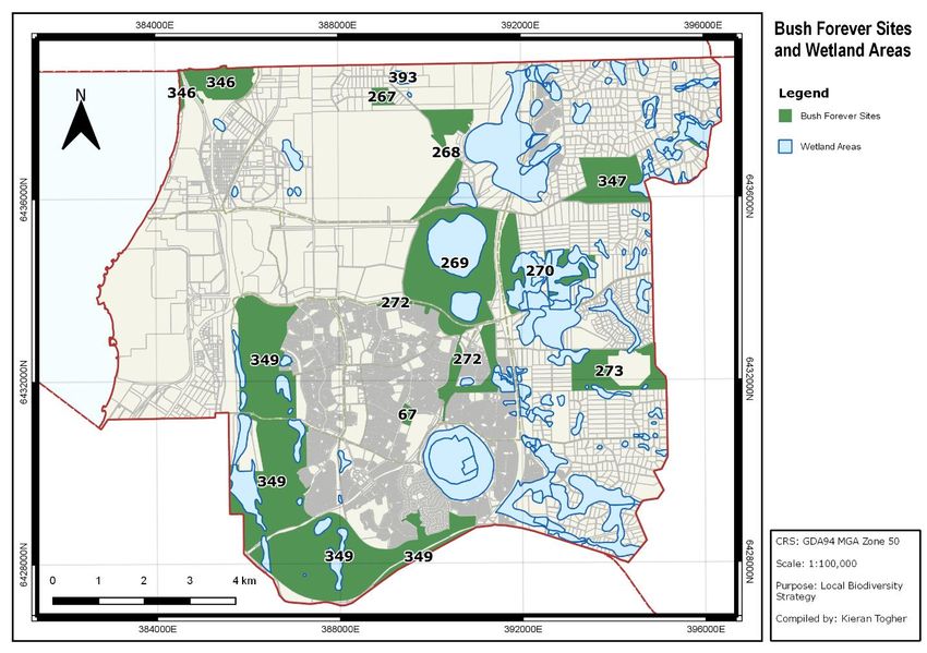
D19/18265 LOCAL BIODIVERSITY STUDY 1. Introduction The Local Planning Strategy (LPS) aims to provide a land use planning vision extending to 2050 for the City of Kwinana (City), thus setting out a long-term strategic direction for land use, and in the process, consider a wide range of local economic, social and environmental issues that are affecting the City. The Local Biodiversity Study (LBS), one of the studies that informs the preparation of the LPS, aims to identify the issues associated with the City’s biodiversity values and areas and provide guidance to future protection, retention and management. 2. Importance of Biodiversity 2.1 Biodiversity - why is it important? Biodiversity underpins the ecological processes necessary for maintaining marine and estuarine quality, soil fertility, and clean, fresh water and air. Biodiversity is also fundamental to the quality and character of the landscape and provides recreational opportunities, aesthetic value and cultural identity. A land use framework/mechanism should recognise the importance of biodiversity while considering changes to land use, which could include consideration of any future potential value, such as a source of genetic material. 2.2 Values and Benefits of Protecting Biodiversity Biodiversity plays a vital role in sustaining the living networks and systems that provide humans with health, food, wealth, fuel and the vital services our lives depend on. These organisms, ecosystems and ecological processes supply humans with oxygen and clean water, help keep our lives in balance and regulate the climate. The benefits derived from protecting biodiversity are both tangible, for example economic returns and tourism, and intangible, for example heritage values and the mere existence of humanity. The ‘ecosystem services’ provided by the natural environment in Australia are worth an estimated $1327 billion in economic terms (see Table 1). Biodiversity and the ecosystem services it provides has been compared to a bank account of capital assets capable of paying life-sustaining dividends in perpetuity, but only if the capital is maintained. Naturally vegetated areas in Western Australia’s cities and towns support significant biodiversity and provide important amenity to urban residents (Environmental Protection Authority 2013). The rich diversity of Western Australia is in decline due to human activities. Local government can slow, stop and reverse this trend by showing leadership within the community and also encouraging local land and property owners to conserve native flora and habitats of fauna. Local governments can and should use their position to: Regulate land use;
D19/18265
Utilise available powers to influence community behaviour through implementing
biodiversity friendly regulations and planning provisions;
Promote and demonstrate environmentally, ecologically and socially responsible
behaviour;
Offer community education programs and staff training; and
Provide incentives for sustainable natural resource management on private land.
Table 1 Four main types of ecosystem services (Adapted from Lismore City Council
Biodiversity Management Strategy 2015)
PROVISIONING SERVICES
o Food, including bush tucker, fibre, fuel and many medicines
o Genetic resources
o Biochemicals
o Fresh water
REGULATING SERVICES
o Resistance to invasion by weeds
o Herbivory – food for animals
o Pollination of crops and natural vegetation
o Seed dispersal of crops and natural vegetation
o Climate regulation
o Pest regulation
o Disease regulation
o Natural hazard protection
o Moderation of extreme weather and its impacts
o Regulation and protection from erosion and flood damage
o Mitigation of the impacts of drought and flood
o Water purification
SUPPORTING SERVICES
o Primary production e.g. agriculture, forestry and fisheries
o Provision of habitat
o Nutrient cycling
o Soil formation and retention
o Decomposition of wastes and cycling of nutrients
o Production of oxygen and maintain air quality
o Water cycling
CULTURAL SERVICES
o Tourism and recreation resources
o Enhancement of landscape and aesthetic amenity
o Spiritual and religious values
o Knowledge system
o Education and inspiration
o Sense of place
o Improvement of the overall health of the community
People and community place six different values on biodiversity according to Williams et. al.
(2001) (Table 2).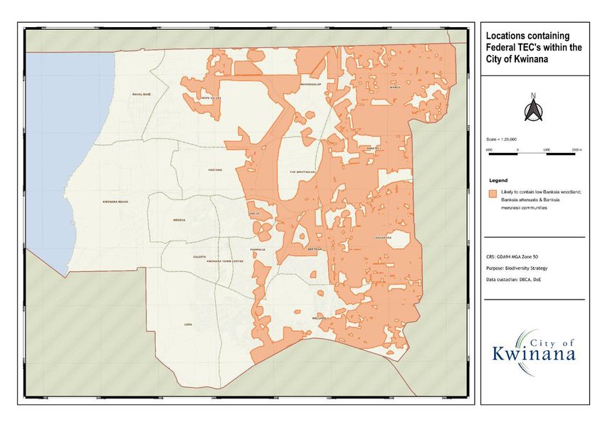
D19/18265
Areas with high levels of biodiversity are more easily able to withstand significant
environmental changes and disturbances than areas of lower diversity. Conserving
biodiversity is an essential part of safeguarding our biological life support systems.
Table 2 Value of biodiversity (based on Williams et al. 2001)
Values Examples
Direct Food
utilitarian Feed stock
Building materials (timber, fibres)
Medicines
Genetic material
Indirect Maintaining water quality
utilitarian Sequestering carbon
Hydrological functions
Soil stability
Decomposition and assimilation of wastes
Aesthetic and Enjoying landscapes (e.g. Coral Reefs, National Parks)
recreational Enjoying specific taxa (e.g. birds, trees, whales)
Hiking
Bird watching
Fishing
Scientific and Scientific discovery can lead to utilitarian values
educational Education in wide range of areas (botany, zoology, ecology)
Intrinsic, Cultural and religious systems
spiritual and Ethical: non-human forms have intrinsic value
ethical
Future or Further research in the future may reveal significance (e.g.
‘option’ medicinal)
Existence value: satisfaction in knowing it exists
Bequest value: knowing it will exist for future generations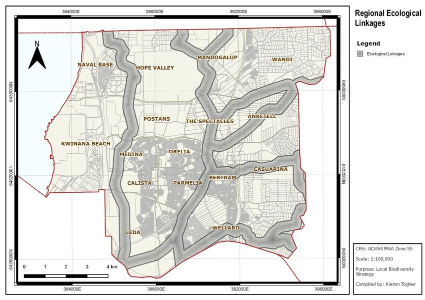
D19/18265
3.0 Planning and Legislative Framework
The protection of biodiversity and conservation areas in Western Australia is achieved
through a hierarchy of planning and legislative framework. A combination of statutory and
non-statutory planning processes and instruments address matters related to the retention
and protection of flora and fauna, and management of habitats.
3.1 Federal Government
3.1.1 Environment Protection and Biodiversity Conservation Act 1999
The Environment Protection and Biodiversity Conservation Act 1999 (the EPBC Act) is the
Australian Government’s central piece of environmental legislation. It provides a legal
framework to protect and manage nationally and internationally important flora, fauna,
ecological communities and heritage places as defined in the EPBC Act as matters of
national environmental significance. Specifically, the EPBC Act aims to:
provide for the protection of the environment, especially matters of national;
environmental significance;
conserve Australia's biodiversity;
protect biodiversity internationally by controlling the international movement of wildlife;
provide a streamlined environmental assessment and approvals process where matters
of national environmental significance are involved;
protect Australia’s world and national heritage; and
promote ecologically sustainable development.
The EPBC Act tries to promote and protect threatened species through two principal
mechanisms:
A permit system, by which the taking, trading or damaging of listed and protected
species and ecological communities can be authorised, and acting without a permit is an
offence; and
An environmental impact assessment process for actions that have a significant impact
on a matter of national environmental significance.
3.1.2 Draft Australia’s Strategy for Nature 2018-2030: Australia’s biodiversity conservation
strategy and action inventory 2016
This strategy is a shared roadmap to care for and sustainably manage nature over the years
to 2030. It provides a long-term vision for nature in Australia and identifies goals and
objectives to guide the collective efforts of governments and other sectors.
Once it is finalised, the strategy will be supported by an action inventory identifying what
local, state/territory and federal governments are doing to achieve the goals and objectives
of the strategy. The inventory will also help non-government stakeholders to identify where
their effort can support national areas of focus.
The objectives outlined in the draft Strategy are:
Encourage Australians to get out into nature
Empower Australians to be active stewards of nature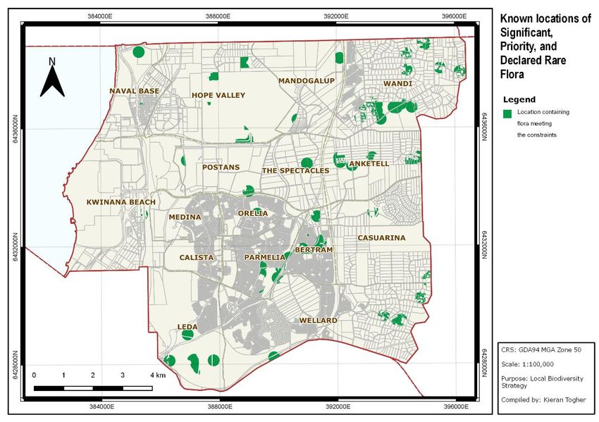
D19/18265
Increase Australians’ understanding of the value of nature
Respect and maintain traditional ecological knowledge and stewardship of nature
Improve conservation management of Australia’s landscapes, seascapes and aquatic
environments
Maximise the number of species secured in nature
Reduce threats to nature and build resilience
Use and develop natural resources in an ecologically sustainable way
Enrich cities and towns with nature
Increase knowledge about nature to make better decisions
Share and use information effectively
Effective measurement to demonstrate our collective efforts
3.2 State Government
3.2.1 Wildlife Conservation Act 1950
The Wildlife Conservation Act 1950 (Wildlife Conservation Act 1950) provides for the
conservation and legal protection of flora and fauna. Specifically, the Act provides that:
All species of native fauna are protected unless declared otherwise by the Minister
for the Environment.
The Minister may request that certain species, listed as 'threatened', be given special
protection.
It is an offence to 'take' protected or threatened fauna without authorisation from the
Department of Biodiversity Conservation and Attractions (DBCA). 'Taking' includes
killing, hunting and disturbing.
The Minister may declare an 'open season' on certain protected native species at
certain times and in certain locations.
3.2.2 Conservation and Land Management Act 1984
The Conservation and Land Management Act 1984 (CALM Act), administered by DBCA,
applies to all land under the control of the Conservation Commission including State forest,
timber reserves, national parks, conservation parks, and nature reserves. The DBCA is
responsible for the conservation and protection of flora and fauna throughout the State and
is required to promote and encourage rehabilitation of land and conservation of biodiversity
throughout the State.
3.2.3 Environmental Protection Act 1986
The Environmental Protection Act 1986 provides for the prevention, control and abatement
of pollution and environmental harm; for the conservation, preservation, protection,
enhancement and management of the environment; and for matters incidental to or
connected with the abovementioned, specifically:
where a development proposal is likely to have a significant effect on the environment, a
proponent may refer the proposal to the Environmental Protection Authority for a
decision on whether or not it requires assessment under this Act
A clearing permit is required to clear native vegetation unless the clearing is exempted
in specific cases.
A works approval is required for works undertaken on a prescribed premise.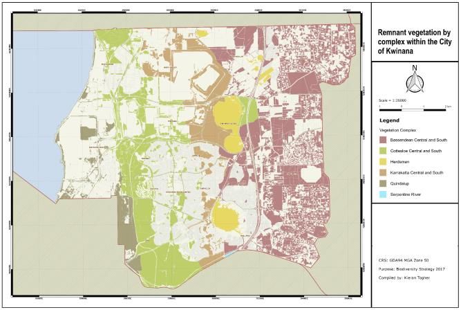
D19/18265

3.2.4   Soil and Land Conservation Act 1945
The Soil and Land Conservation Act 1945 is the main act directed towards controlling land
and soil degradation. The Act defines land degradation as soil degradation and the removal
or deterioration of natural or introduced vegetation where it diminishes the future use of the
land.

Landowners who wish to protect and manage native vegetation on their property may enter
into a conservation covenant with the Commissioner under section 30 of the Soil and Land
Conservation Act 1945. Non-compliance with the Act may result in Soil Conservation Notice
being issued. Soil Conservation Notices are a legally binding directive for landowners to take
certain management steps aimed at mitigating the identified problems.

This legislation allows local governments to require the use of covenants in development to
protect or offset environmental values. Where local government intends to undertake works
which involve clearing or drainage from under the land, the Commissioner for Soil and Land
Conservation must be notified accordingly.

3.2.5   Planning and Development Act 2005
The integration of local biodiversity conservation into statutory land use planning is provided
for in the Planning and Development Act 2005 (PDA). The PDA requires Local Planning
Schemes (LPS) to be referred to the EPA in order for the EPA to decide whether or not the
scheme requires environmental assessment. This provides the opportunity for a strategic
assessment of significant environmental impacts identified on land affected by the LPS.

The PDA has established biodiversity as a valid planning consideration in “Schedule 7 -
Matters which may be dealt with by planning scheme”. This incorporates provision for
preservation and conservation matters, including ‘the conservation of the natural
environment of the scheme area, including the protection of natural resources, the
preservation of trees, vegetation and other flora and fauna, and the maintenance of
ecological processes and genetic diversity’.

According to the PDA, the above matters apply to State Planning Policies (section 26(3)),
Region Planning Schemes (section 34(2)), Local Planning Schemes (section 69(1)(b)), and
conditions of subdivision (section 138(2)).

3.2.6   State Planning Policy No. 2.0 - Environment and Natural Resources Policy 2003
        (SPP 2.0)

The policy measures in SPP 2.0 in regards to biodiversity are aimed at adopting a holistic
approach for its retention, protection and management. Specifically, SPP 2.0 recognises that
the planning strategies, schemes and decision-making should support conservation,
protection and management of native remnant vegetation where possible, to enhance soil
and land quality, water quality, biodiversity, fauna habitat, landscape, amenity values and
ecosystem function.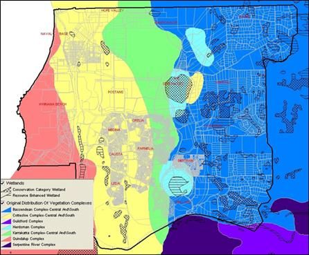
D19/18265

With respect to protecting valued landscapes, SPP 2.0 recognises that planning strategies,
schemes and decision-making should:
a) Identify and safeguard landscapes with high geological, geomorphological or ecological
    values, as well as those of aesthetic, cultural or historical value to the community, and
    encourage the restoration of those that are degraded.
b) In areas identified above, consider the level or capacity of the landscape to absorb new
    activities and incorporate appropriate planning and building design and siting criteria to
    ensure that new development is consistent and sensitive to the character and quality of
    the landscape.
c) Consider the need for a landscape, cultural or visual impact assessment for land use or
    development proposals that may have a significant impact on sensitive landscapes.

3.2.7   State Planning Policy No. 2.6 – State Coastal Planning Policy 2013 (SPP 2.6)
SPP 2.6 is a higher order policy for all coastal matters. One of the main objectives of this
policy is to protect, conserve and enhance coastal zone values, particularly in areas of
landscape, biodiversity and ecosystem integrity, indigenous and cultural significance.

SPP 2.6 prescribes that any rezoning, structure planning, subdivision, strata subdivision or
development should ensure that a coastal planning strategy or coastal foreshore
management plan is prepared and implemented by the local government and/or proponent
for the coastal foreshore reserve.

3.2.8   State Planning Policy No. 2.8 - Bushland Policy for the Perth Metropolitan Region
        2010 (SPP 2.8)

SPP 2.8 is a supplementary policy under the environment and natural resources policy (SPP
2.0) and seeks to address, in more detail, the protection and management of significant
bushland areas, particularly those identified for protection through strategies and processes
at the regional and local level in the Perth Metropolitan Region (PMR). Regionally significant
bushland areas are known as ‘Bush Forever sites’ and are identified in this Policy.

SPP 2.8 contains policy measures for ‘local bushland’ and also provide for the preparation
by local government of a local bushland protection strategy or local biodiversity strategy, in
accordance with the Local Government Biodiversity Planning Guidelines for the Perth
Metropolitan Region (WALGA 2004). The local biodiversity strategy should be prepared in
consultation with affected landowners, broader community, and relevant government
agencies.

3.2.9   Bush Forever Policy 2000 – Keeping the Bush in the City
The Bush Forever policy provides a policy and implementation framework that is aimed to
ensure bushland protection and management issues in the PMR are appropriately
addressed and integrated with broader land use planning and decision-making. Besides, the
policy recognises the protection and management of significant bushland areas as a
fundamental consideration in the planning process, while also seeking to integrate and
balance wider environmental, social and economic considerations. Bush Forever Sites,
which are representative of regional ecosystems and habitats, play a central role in the
conservation of Perth’s biodiversity.
D19/18265 Bush Forever identifies 51,200 hectares of regionally significant bushland recommended for protection and management in 287 Bush Forever sites, and includes lands with either some level of protection or unprotected land in both public and private ownership. The City has 953 ha of Bush Forever Sites. 3.2.10 State Planning Strategy 2050 The State Planning Strategy presents a vision for Western Australia to 2050 and beyond based on a framework of planning principles, strategic goals and strategic directions. Specific to biodiversity and natural areas, Section 4 Environment of the Strategy aims to effectively manage the biodiversity values within the formal conservation and off-reserve system and associated threats by developing ecological linkages and protecting landscapes. 3.2.11 South Metropolitan Peel Sub-regional Planning Framework 2018 This is a subset of the over-arching Perth and Peel @3.5million strategy and has considered where future homes and jobs will be located; what community and social infrastructure will be required; better integrated use of existing infrastructure; protection of important environmental assets and critical services; and staging and sequencing of future development. Specific to protecting biodiversity, it sets out proposals to set aside ‘planning investigation areas’ at the eastern part of Kwinana. Key environmental considerations for these areas include to investigate the implications of/for significant on-ground environmental attributes and Peel-Harvey catchment considerations. 3.2.12 Draft Perth and Peel Green Growth Plan for 3.5 million 2015 The draft Green Growth Plan is a set of documents, which provide a comprehensive approach to the avoidance and mitigation of environmental impacts and a committed Conservation Program. It is intended that this plan will deliver significant improvements to the protection and management of the environment as the Perth and Peel regions grow to a population of 3.5 million people. The draft plan indicated that there were going to be a variety of impacts in the City of Kwinana ranging from loss of vegetation in some areas, additions to conservation estate and areas where rehabilitation may have been considered. As of June 2018, the WA Government has suspended work on this Plan and appointed an independent four-member panel to undertake the review over the next six months, which include consulting across governments, industry, local governments and non-government organisations. 3.3 Regional Planning 3.3.1 Regional Natural Resource Management Strategies Regional natural resource management planning encompasses a multi-stakeholder approach to consultation and to the provision of a coordinated delivery of natural resource management outcomes in a range of areas including biodiversity, water quality and land use planning.
D19/18265

In the Perth Metropolitan Region, the Swan Region Strategy for Natural Resource
Management has been developed through a consultative process with stakeholder groups
including State and Local Government, community, industry and research institutions.

The City works in accordance with the Swan Region Strategy to deliver outcomes that lead
to the protection of its assets including air, land, coastal, water, biodiversity and cultural
heritage.

3.4     Local Government
The City does not have an adopted ‘biodiversity strategy’, and if so would have provided a
framework and/or lead to prepare either a revised strategy, or a new strategy by considering
the State initiated strategic directions. It is expected that the outcomes of this Study could
provide the guidelines necessary to prepare a biodiversity strategy for the City.

The role of the Local Government is to refer to State and Federal policies and guidance on
matters to do with Flora and Fauna conservation. The City’s role is to ensure that due
consideration of the values present, their location and extent has been considered in regards
to ensure that the best outcome is pursued.

The biodiversity strategy is to amass the guidance from a variety of agencies, apply to the
remaining natural areas within the City, determine if there are areas where the guidance
applies and develop strategies to ensure that the impact on these values is minimised.

3.4.1   City of Kwinana Local Planning Scheme No 2 (LPS2)
The City’s LPS2 through Section 6.16.2 “Areas of landscape protection” provides for
measures to be adopted for conserving the natural ecological values and amenity values
existing in those areas, while allowing development.

6.16.2 Areas of Landscape Protection

6.16.2.1    Council's objective in setting aside Areas of Landscape Protection is to conserve
            areas of natural ecological value or landscape amenity whilst at the same time
            allowing development as provided in the Zoning Table No. 1 of the Scheme.

6.16.2.2    No person shall, in any Area of Landscape Protection, without Council's Planning
            Approval in writing;
            (a) Carry out clearing of trees or other vegetation;
            (b) Carry out any filling, dredging or changes to the contour of the land;
            (c) Erect any advertising sign,
            (d) Erect or construct any building or outbuilding,
            (e) Degrade any natural wetland system,
            (f) Detract from the amenity of the locality.

6.16.2.3    In considering an application for Planning Approval in respect of any land within
            an Area of Landscape Protection, Council shall have regard to the following:
D19/18265
(a) The overall impact of the proposed development on the landscape amenity
of the area and the desirability of limiting or modifying the siting,
construction, design or materials of any building or associated services;
(b) The need for an overall management plan prepared by Council in
consultation with the affected owners as a prerequisite to any Planning
Approval being issued;
(c) The extent to which any subdivision proposal should guarantee the
protection of natural ecological features or areas of landscape amenity;
(d) The desirability of minimising the effect of new road construction including
earthworks and clearing of vegetation within road reserves.
3.4.2 City of Kwinana Natural Areas Management Plan 2014-2024
The Natural Areas Management Plan aims to prioritise management issues and threats
facing reserves identified in the Management Plan (21 natural area reserves comprising
coastal, woodland and wetland communities), including investigating and implementing
suitable methods to control these issues and threats. The following implementation
programs have been established to achieve the objectives of the Management Plan:
Weed control program;
Access control program;
Retention, regeneration and revegetation program;
Fire management and fuel reduction program;
Pest and bio-security program; and
Community education and volunteer program.D19/18265
4.0 Biodiversity and Conservation Areas Profile
The biodiversity profile in Kwinana was developed by analysing and collating relevant
information from a range of sources at a local, regional, state and national scale. The
following section provides a summary of biodiversity values existing in Kwinana and includes
flora, fauna and its habitat, threatened species, populations and ecological communities.
4.1 Distribution of Areas having Biodiversity Values
The category of biodiversity and conservation areas that are the responsibility of State or
local government within City is outlined in Table 3. This data has been obtained through
desktop study, including the approved Structure Plans, Perth Biodiversity Project, and the
Metropolitan Region Scheme. The data excludes the area of LNAs in POS resulted from
subdivision process.
Table 3 Government Agencies and Biodiversity Conservation
Agencies Main Categories of Protection Status Area in the
Natural Areas Categories City (ha)
State Bush Forever Sites Native Vegetation
Government DBCA managed Exists in CALM Estate
Estates: and Regional Parks
o National Parks, Vegetated and non-
o State Forest, vegetated Conservation
o Nature Reserves, Category Wetlands and
2,342
o Conservation Parks Resource Enhancement
Parks and Recreation Wetlands
Reserves through the Environment Protection
Metropolitan Region Policy Lakes
Scheme (MRS) Parks and Recreation
Reserves
City of Kwinana Local Natural Areas, but Public Open Space (POS)
exclude:
DBCA managed
estates;
Regional Parks; and
2,148
Bush Forever sites not
managed by Local
Government or in
private ownership.
Originally, the City had 11,980 ha of natural areas (i.e. pre-European). Table 4 shows that
4,490 ha remains, 2,342 ha is under State Government management and 2,148 ha are Local
Natural Areas (LNA) which are the responsibility of the City (this excludes Bush Forever
Sites in private ownership).D19/18265 4.1.1 Bush Forever Sites Section 6.2.9 provide details about Bush Forever sites. Map 1 and Table 4 depict the type and extent of Bush Forever sites remaining in the City. Map 1 Bush Forever Sites .
D19/18265

Table 4            A Snapshot of Bush Forever Sites (20131)
 Bush                                                                                                                                                    Vegetate       Water
                                                                                                                                          BF Area                                   Cleared
 Forever        Location                        Ownership                  Management                                                                    d Area         Area
                                                                                                                                          (ha)                                      (ha)
 Sites                                                                                                                                                   (ha)           (ha)
 67             Parmelia Avenue                 WAPC                       Crown Reserve vested with the City
                                                                                                                                          8.56           6.96           0.00        1.60
                Bushland
    267         Mandogalup Road                 WAPC                       WAPC
                                                                                                                                          16.33          16.05          0.00        0.28
                Bushland, Hope Valley
    268         Mandogalup Road                 Commercial,                Part no management authority, and part Crown
                bushland, Mandogalup            Private,                   reserve vested with the City                                   99.97          88.19          0.00        11.78
                                                State Government
    269         The Spectacles                  Commercial,                Part WAPC, part Department of Water and
                Bushland                        Private,                   Environmental Regulation (DWER), part no
                                                                                                                                          422.46         386.92         2.96        32.88
                                                State Government           management agency

    270         Sandy Lake and                  WAPC,                      Part WAPC, part DWER, part no management
                adjacent Bush land,             Commercial                 agency                                                         202.55         188.35         11.34       2.87
                Anketell
    272         Sicklemore Road                 Commercial,                Part unallocated crown land, part drain reserve,
                Bushland, Parmelia /            Private,                   part Crown reserve vested with the City, part no               107.60         87.01          0.00        20.60
                Casuarina                       State Government           management agency
    273         Casuarina Prison Bush           State Government           Crown reserve vested in Department of Corrective
                                                                                                                                          113.43         112.35         0.00        1.08
                land                                                       Services
    346         Brownman Swamp, Mt              State Government,          Part DBAC conservation Park, part Crown
    (partial)   Brown Lake and                  Water Corporation,         Reserve vested in Local Government, part
                                                                                                                                          558.3          -              -           -
                adjacent Bushland,              WAPC                       unallocated Crown land, part no management
                Henderson / Naval Base                                     agency (Beeliar Regional Park)

1
    Source:     1. WA Parliament (2012) Tabled Paper for Legislative Council Question on Notice 5878 – List of current Bush Forever sites and managers for each site, August 2012, Perth,
                Western Australia.
                2. Western Australian Local Government Association (2014) Towards Establishing a Green Network, Perth, Western Australia.
D19/18265
347 Wandi Nature Reserve WAPC, Part DBAC Nature Reserve, part WAPC 170.231
(partial) and adjacent Bush Land, State Government (Jandakot Regional Park) (412.3 - - -
Wandi / Oakford total)
349 Leda and adjacent Commonwealth, Part DWER nature reserve, part Vacant Crown
Bushland WAPC, Land, part WAPC part Crown Reserve vested with 1,107.51 917.95 4.86 184.70
State Government the City, part no management agency
393 Wattleup Lake and Commercial, No Management Agency
adjacent Bushland, Private, 18.9 - - -
Wattleup / Mandogalup State Government4.1.2 DBCA and DPLH Reserves DBCA and DPLH manages conservation wetland reserves and Beeliar Regional Park (partial in the City). 4.1.3 City managed Local Natural Areas (LNA) Many LNAs in the City have been cleared or modified for farming, industrial and residential development purposes. Currently, these LNAs are under threat from various sources, including urbanisation (for more details, refer to Section 5.0 Threats to City’s Biodiversity and Conservation Areas). The LNAs are a significant part of the biodiversity assets of a local government and this study focusses on LNAs. They are broadly categorised into ‘vegetation complexes’ and contain Threatened Ecological Communities (TECs), Priority Ecological Communities (PECs), Declared Rare Flora, priority fauna and its habitat, and other vegetation having biodiversity values. 4.2 Vegetation component 4.2.1 Vegetation Complexes In the Perth Metropolitan Region, the most common way to interpret and quantify ecological communities based on area are the vegetation complexes defined by Heddle, Longeran and Havel (1980) and Mattiske and Havel (1998). These complexes have been mapped across the region in a way that allows them to be used for quantitative targets, based on original and current area (WALGA & PBP 2004). These vegetation complexes are based on the patterning of vegetation at a regional scale and reflect the underlying key determining factors of landform, soil and climate. These complexes contain communities of both plant and animals that change with variations in soils, slope, and vegetation condition. There are seven vegetation complexes found within the City (Table 5). These include Quindalup, Cottesloe (Central and South), Karrakatta (Central and South), Herdsman, Serpentine River, Bassendean (Central and South), and Guilford. Five of these vegetation complexes, Bassendean (Central and South), Herdsman, Guilford, Karrakatta (Central and South) and Cottesloe (Central and South) are considered regionally significant, as less than 10% of the original extent of the complexes are found within formally protected reserves. Map 2 depicts the original extent (pre-European) of the vegetation complexes that existed in the City. D19/18265
Map 2 Original extent of vegetation complexes in the City (adapted from the Local
Biodiversity Strategy Draft for Public Discussion 2007)

Where do Vegetation Complexes Occur in the City?

1.   Most occurrences of the remaining Bassendean Central and South Vegetation Complex
     are located within the Rural A, Rural B, Special Rural, and Development zoned areas of
     the Wandi, Anketell, Casuarina and Wellard suburbs.

     The Bassendean Central and South Complex is made up a number of different
     vegetation communities including Banksia-dominated woodlands (e.g. Banksia
     menziesii), wetlands with flooded gums (Eucalyptus rudis) and paperbarks (Melaleuca
     preissiana), or heathlands of Pericalymma ellipticum and Hypocalymma angustifolium.

2.   The Herdsman Vegetation Complex is typically seasonal wetland type vegetation
     ranging from woodlands of flooded gums (Eucalyptus rudis) through to dense heaths
     and sedgelands.

D19/18265
3. Vegetation types of the Karrakatta Central and South Vegetation Complex include
woodlands dominated by Tuart, Jarrah, Banksia or she oak (Allocasuarina fraseriana)
and seasonal wetlands with Melaleuca rhaphiophylla.
4. Cottesloe Central and South Vegetation Complexes include highly saline seasonal
wetlands, woodlands of Tuart, Jarrah and Marri and low Banksia dominated woodlands.
The vegetation types in this complex are influenced by Tamala Limestone.
More than 40% of the LNA of this vegetation complex is zoned Residential, General
Industry, or Town Centre and provide few opportunities for natural area protection.
5. The Quindalup Vegetation Complex is typically coastal vegetation and includes
vegetation types on dune ridges and the seasonal wetlands that sometimes form in
between the dunes. A wide variety of vegetation types occur in this complex supporting
a range of distinctive floristic communities.
Table 5 Status of Vegetation Complexes
Pre- 2018 % of
European Local original
Vegetation Complex extent Natural
Area
Ha Ha %
Bassendean Complex -Central and 4,679 1366.322 29.2
South
Cottesloe Complex-Central and South 3,790 227.7197 6.01
Guildford Complex 19 0 0
Herdsman Complex 579 107.5711 18.58
Karrakatta Complex-Central and South 1,634 333.7041 20.42
Quindalup Complex 1,274 113.0365 8.87
Serpentine River Complex 4 0 0
Total 11,978 2148.3534 17.93
The above table shows that just under 18% of the pre-European vegetated area remain in
LNAs, These areas do not have the same level of formal protection that exists in Bush
Forever sites, and DBCA and DPLH managed reserves.
4.2.2 Wetland and Riparian Corridor Vegetation
Wetland vegetation is essential for the maintenance of clean water supply and provides
habitat and refuge for many fauna. Riparian refers to the zone along or surrounding a water
body where the vegetation and natural ecosystems benefit from and are influenced by the
passage and storage of water. Riparian land provides a number of important environmental
services and other values that are given below:
a diversity of habitat for terrestrial, riparian and aquatic species
food for aquatic and terrestrial fauna
D19/18265 movement and recolonisation of plant and animal species and populations
shading and temperature regulation
conveyance of flood flows
settlement of high debris loads
maintaining water quality through trapping of sediment, nutrients and other contaminants
an interface between development and waterways
passive recreation
visual amenity
a sense of place with green belts naturally dividing localities and suburbs
Wetlands, such as the Spectacles and Bollard Bullrush Swamp have been important for
food, recreation, and cultural reasons for tens of thousands of years, and continue to serve
these purposes today. These and other wetlands provide a home for endangered birdlife and
orchids, filter our water, and provide a water storage function which protects against floods
(Department of Environment and Conservation, 2012).
4.2.3 Coastal Vegetation
Coastal vegetation includes all vegetation that grows on beaches and sand dunes or may
have an affinity with coastal locations. This vegetation provides considerable protection to
the adjacent coastline through reducing wind erosion of beaches.
Additional to the physical buffering of weather provided by coastal vegetation, one particular
vegetation type with an affinity to coastal locations is present regionally being the
Sedgelands in Holocene Dune Swales of the southern Swan Coastal Plain Floristic
Community.
4.3 Other Biodiversity Feature components
4.3.1 Threatened Ecological Communities (TECs) and Priority Ecological Communities
(PECs)
An ecological community is a naturally occurring group of plants, animals and other
organisms that interact in a unique habitat. Its structure, composition and distribution are
determined by environmental factors such as soil type, position in the landscape, altitude,
climate, and water availability.
An ecological community becomes threatened when it is at risk of extinction. That is, the
natural composition and function of the ecological community has been significantly depleted
across its full range. This can occur for a number of reasons including clearing of native
vegetation, altered fire regimes, non-native or invasive species, climate change, water
diversion, pollution and urban development. Because of these threats, many ecological
communities in Australia have undergone, and continue to be affected by a rapid and
significant reduction in geographic distribution and/or ecological function.
In Australia, three categories exist for TECs under the EPBC Act: critically endangered,
endangered, and vulnerable. Only two known State TECs are recorded to occur in the City,
the Honey myrtle (Melaleuca huegelii - M. systena) on limestone community (This TEC
occurs within the Cottesloe Central and South vegetation complex) and Communities of
D19/18265Tumulus Springs (Organic Mound Springs, Swan Coastal Plain). It is highly likely that there
are TECs present that have not been recorded.
In 2016 the Federal Government Listed Banksia Woodlands of the Swan Coastal Plains a
TEC. This has significant implications for the City of Kwinana as much of the remnant
vegetation would now qualify as a TEC and have another significant layer of protection.
Planning mechanisms are yet to adequately address the implications this listing will have on
the development process in the medium and long term frameworks.
PECs are ecological communities that are likely to be under threat and are either awaiting
further information to establish their status of threat. Four PECs occur in the City:
Coastal shrublands on shallow sands, southern Swan Coastal Plain.
Banksia ilicifolia woodlands, southern Swan Coastal Plain.
Eucalyptus gomphocephala - Agonis flexuosa woodlands, southern Swan Coastal Plain
Low-lying Banksia attenuata woodlands or shrublands.
4.3.2 Declared Rare Flora (DRF) and Specially Protected Fauna (SPF)
At present, the City requires that flora and fauna surveys be carried out to determine the
presence of any DRF or SPF. This normally occurs during the structure planning process or
as a part of a local planning scheme amendment. Table 7 lists Declared Rare Flora and
Specially Protected Fauna known to occur in the City.
Table 7 Declared Rare Flora and Specially Protected Fauna
Declared Rare Flora Specially Protected
Fauna
Diuris micrantha (Swamp Donkey Orchid) – Calyptorhynchus
Bertram latirostris (Carnaby’s
Caladenia huegelii (King Spider Orchid) – Black Cockatoo) –
Wandi, Bertram Oakford and surrounds
Drakaea elastica (Glossy-leaved Hammer Orchid) - Anketell
It is not possible to estimate how many additional DRF or SPF will be identified in the City in
the future as these species are generally only located with on-ground biological surveys.
4.3.3 Priority Flora and Fauna
Priority Flora and Fauna are native species that are either under consideration as threatened
species and need further survey to adequately determine their status, or are adequately
known and require monitoring to ensure their security does not decline. Table 8 lists Priority
Flora and Fauna species (refer to Map 3 and Map 4 respectively) known to be present in the
City.
Table 8 Priority Flora and Fauna
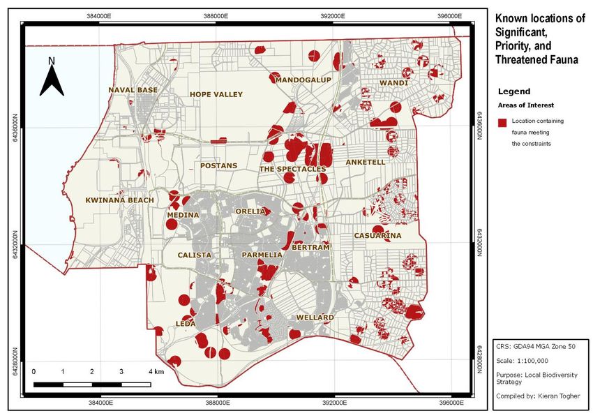
D19/18265Priority Flora Location Priority Aponogeton hexatepalus Bertram 4 (Stalked Water Ribbons) Dodonaea hackettiana The Spectacles 4 (Hackett’s Hopbush) Priority Fauna Location Priority Isodon obesulus Hope Valley / Oakford / Bertram / Wellard 5 fusciventer (Quenda) East / Wellard / Leda Macropus irma (Western Wellard / Leda / Casuarina 4 Brush Wallaby) The conservation status of flora and fauna and the management of priority flora and fauna is managed by the State Government. It is not possible to estimate where occurrences of these species will be found until further ecological surveys are conducted. Map 3 Known locations of Declared and Priority Flora D19/18265
Map 4          Known locations of Declared and Priority Fauna

4.3.4   Ecological Linkages
Ecological Linkages link locally and regionally significant natural areas and provide stepping
stones for flora and fauna. The consideration of linkage between protected natural areas is
important to meet the needs of avifauna and maintain long-term movement of genes
between the former ranges of species.

Avifauna, such as birds, bats, many insects, frogs and reptiles, need to move across the
landscape to meet feeding and breeding needs and deal with threats such as fires and feral
animals. Many of these species are important in moving pollen and seeds between natural
areas that might otherwise be isolated within developments.

To be effective, Regional Ecological Linkages (REL) should incorporate the major variation
in plant communities and fauna habitat typical of the region so that the widest range of flora
and fauna possible can use the links. For example, only using waterways as RELs will limit
the movement of flora and fauna to only those species that utilise riparian habitat (WALGA &
PBP 2004).

Similarly, Local Ecological Linkages (LEL) play an important role in improving the viability of
localised natural areas that are too small or too degraded to survive on their own. Local
linkages consist of stepping stones formed by POS or other public lands such as schools
within the shortest distance between Bush Forever areas and existing local conservation

D19/18265
reserves. It is necessary that these linkages should include as many ecological communities
to maximise usage by diverse fauna and flora.

The ‘Towards establishing a Green Network’ Study (2014) identified RELs for the City (Map
5). The Study indicated that there is scope for developing and maintaining local linkages
using existing ‘stepping stones’ having biodiversity values (Table 9)

Map 5 Regional Ecological Linkages

D19/18265
Table 9       New Local Ecological Linkages identified in the ‘Towards establishing a
              Green Network’ Study (2014)

 Conservation         Recommended Actions
 Values
 Local linkage        Due to the alignment of Kwinana Freeway, east-west movement of
 between K7           terrestrial fauna is limited in this part of the landscape, however, there
 through K37, K34     are several patches retained with new subdivisions within 500m from
 to C32               each other and the linkages follows a drain reserved in the LPS as
                      Parks, Recreation and Drainage. Manage the Parks and recreation
                      reserve and all future POS areas to maximise fauna habitat provision.

 Local linkage        Two opportunities can be explored, one utilising vegetation retained
 between K23 (BF      within the Special Rural properties (as mapped in the Environmental
 270) and K25 (BF     Planning Tool). Another opportunity exists within Rural Water Resource
 273)                 lands east of Bombay Boulevard and adjoining a golf course.
                      Improvement of vegetation condition within the golf course and the
                      Rural Water Resource properties will improve connectivity between the
                      two regionally significant bushland areas.

 East-west linkage    There are no opportunities to establish a good linkage between the
 between two          coastal foreshore reserves and bushland reserves in the eastern parts
 major north-south    of the City. K38 and K12 (part of Latitude 32 Structure Plan) are closest
 regional linkages    to the coast but separated by from it by the industrial development.
                      There are three parallel linkages:
                      1. one along Thomas Road consisting of BF272, local recreation
                          reserves
                      2. vegetation along Anketell Road connecting wetlands to be retained
                          as part of Latitude 32 structure plan to BF269
                      3. East-west linkage formed by vegetation within K9, K8 and K7.

The Local Government Biodiversity Planning Guidelines suggest a maximum distance of
between 500 metres (m) and 1000m (but state a preference of 500m) to maintain a linkage
function between natural areas (WALGA & PBP, 2004).

4.3.5   Wetlands
Wetlands are areas that are wet by surface water or groundwater, or both. They remain wet
for long enough periods of time that the plants and animals in them are adapted to and
depend on moist conditions for at least certain part of their lifecycle. Some wetlands are
ephemeral, and their extent will vary depending on climatic conditions.

The City provides for 50m buffers around Conservation Category Wetlands (CCW). In
addition, the City requires developers to produce and implement a management plan for any
CCW retained as part of any subdivision. The Spectacles, Bollard Bullrush, Long Swamp
and Sloans Reserve are examples of CCW Wetlands in the City. The City also requires
developers to produce a Local Water Management Strategy for all subdivisions. As

D19/18265
Resource Enhancement Wetlands (REW) represent wetlands with lower environmental
significance, the City only requires that efforts should be made to retain portions with high
environmental values.
4.3.6 Ecological Corridors
Ecological connectivity is vital to the long-term viability of native flora and fauna, and is
recognised as one of the most effective tools available for conserving biodiversity. Ecological
corridors provide connections between habitat areas across a landscape allowing the
movement of fauna and the transfer of plants through seeds and pollen. The important
functions of ecological corridors include:
Corridors may act as conduits: organisms may pass through the corridor from one
habitat patch to another, ensuring its continued sustenance;
Corridors allow re-colonisation of habitat areas by fauna and flora that have become
locally extinct from events such as fire, disease or poor breeding success;
Corridors permit seasonal movements of fauna between temporarily available
resources; and
Corridors permit gene flow between reserves.
Landscape elements that contribute to ecological corridors in urban environments include
parks, golf courses, street trees and gardens that provide habitat.
D19/182655.0 Results of Investigation – Baseline Data To inform this study, the various protection mechanisms that apply, such as Hydrological Wetlands of the Swan Coastal Plain, Bush Forever, and Threatened Ecological Communities (TECs) were determined and their spatial extent mapped using mapping supplied by the custodians of those data sets. The City undertook an exercise to provide a highly accurate figure of the total vegetated area of Kwinana that involved hand-drawing polygons for each patch of vegetation using GIS and applying recent high quality aerial imagery. Further to this, ground truthing of some areas was undertaken to determine if vegetation on the site was native vegetation or introduced species such as Brazilian Pepper (Schinus terebinthifolia). This mapping exercise included all vegetation and was tenure-blind which produced a map and area of vegetation that represents the total vegetated area in the City, the vegetation area by vegetation Complex (Heddle), and the location and size of each individual polygon. Map 6 displays this data. Map 6 Remnant Vegetation by complex within the City of Kwinana Using this as a base line, several further refinement steps were undertaken using GIS to remove areas that are outside the considerations of this study, being: • Resource and Conservation Category Wetlands and a corresponding 50m buffer D19/18265
•    Bush Forever Sites;
•    Class A Reserves, Nature Reserves and conservation reserves;
•    Known locations of DRF and their respective buffers;
•    Approved Local Structure Plans;
•    DBCA listed TEC’s;
•    EPBC TECs; and
•    Heddle complexes below 30% locally.

The resulting area are those referred to as Local Natural Areas (LNA). The total area of
LNAs within the City is 17.93%. These areas are shown in Map 7. This is not to be confused
with the total vegetated area (39.95%) or the area that is already protected through the state
mechanisms (19.5%).

Map 7          Local Natural Areas within the City of Kwinana

One constraint that has not been applied to the determination of LNAs is the federally listed
Banksia Woodlands of the Swan Coastal Plain TEC. When this layer of protection/protection
mechanism is applied across the City, the areas of LNA covered by legislative protection
increases significantly. Almost all of the remnant vegetation in the City’s east is identified as
a potential listed federal TECs. Map 8 provides an indication of the data that is available.

The Federal Governments listing of Banksia Woodlands of the Swan Coastal plain as TEC is
relevant for the City as much of the vegetation remaining in the City is likely to comprise

D19/18265
vegetation that is now Banksia Woodland TEC. The condition of the vegetation, given that
much of the locations where this vegetation occurs is Rural or Special Rural, is generally
intact meaning that clearing may require consideration of the EPBC Act requirements.
It should be noted that this listing blankets all remnant Banksia Woodland vegetation
although there may be examples where, according to the Conservation Advice, the
protection measure may not be appropriate such as:
areas that have experienced degradation reducing the condition to a point that the
EPBC act is not triggered;
areas where the size of the patches may be too small;
areas where EPBC applications have been made before the listing of the Banksia
Woodland TEC, but TEC exist; and
Areas where TEC may exist outside of the recognized formal extent of the TEC.
The Federal Department of Energy and Environment includes an assessment matrix for
Banksia Woodlands TEC based on size and condition. From this matrix, and other factors
relating to the general trend relating to decreasing patch size of remnant vegetation and the
correlating decrease in diversity, the City refined some of the mapping based on
assumptions relating to the size of patches.
Map 8 Likely locations of the federally listed Threatened Ecological Community
(Banksia Woodlands of the Swan Coastal Plain).
D19/18265Smaller patches are likely to be altered or impacted and are more susceptible to further
alterations and impacts, even if the surrounding area does not have any change in land use
or management practices. If these patches are managed with the intention to prevent further
degradation, and management actions are implemented consistently, then there is a
likelihood that the diversity and function of these smaller patches would improve. This may
often be time consuming and more costly than concentrating equivalent efforts on larger
areas. Nonetheless, property owners with patches of native vegetation need to be
encouraged to manage these areas for conservation and biodiversity value.
Review of the LNAs above and the current levels of protection indicates that there are very
few areas of vegetation in the City that do not have some level of protection or significant
conservation value. There are also areas which have more values than others, more areas
of fragmented vegetation and areas with higher percentages of cleared land.
The above discussion and the series of maps have sought to be presented spatially:
The extent of native vegetation in Kwinana currently;
The areas which this study considers to be LNAs (i.e. are not Bush Forever, nature
reserve, national park etc.);
The discussion and maps have removed from consideration the following:
The LNAs layer has had the mapped Conservation Category and Resource
Enhancement Wetlands (and their buffers) removed as these are protected;
Declared Rare Flora (and their buffers);
State TECs (PECs have not been removed, but have been highlighted); and
Federally Listed TECs (for Kwinana, the Banksia Woodlands TEC has the most
relevancy).
Map 9 shows the above criteria mapped spatially and indicates the level of protection of the
City’s NLA’s. Various protection measures have spatial extents that overlap indicating that
several values cover the same area. These have been mapped and have a colour scale,
indicating increasing protection measures, which ranges from the green spectrum (the
highest level of protection) to the red spectrum (with the lowest level of protection).
The spatial extent of each layer of protection have been projected upon each other in Map 9.
This map demonstrates that there are few areas of remnant vegetation in Kwinana that do
not have some level of protection. These layers of protection need to be considered in the
context of the Local Planning Strategy.
The results show that wetland protection mechanisms have produced a high representation
of wetlands within the native vegetation that remains in the City. Conversely, the historically
fewer protection measures for upland vegetation such as banksia woodlands on the
Bassendean and Spearwood Dunes have reduced the representation of these areas in the
stock of remaining native vegetation. This disparity in protection level was recently adjusted
through the recognition of much of the City’s upland vegetation as a federally-listed TEC.
D19/18265Map 9 Number of protection mechanisms covering Local Natural Areas. The study results indicate that there is increasing challenges when considering the opportunities for development in areas where there is native vegetation due to the increasing conservation value of this remnant vegetation (resulting from increasing scarcity due to ongoing clearing for urbanisation). The impact of human intervention and development is such that native vegetation will become increasingly scarce, to a point where ecosystem and biodiversity functions fail, unless protection measures are implemented that regulate urban development through planning and regulatory frameworks. The cumulative impacts of human activity and development to date in Kwinana need to be recognised, with effective policies needed to protect LNA’S where possible. It is evident that the most significant areas of LNA’s are within the City’s eastern areas which are primarily occupied by Rural and Special Rural lands uses. Section 6 ‘Threats to City’s Biodiversity and Conservation Areas’ discuss how LNA’s can be best protected whilst facilitating appropriate development and land use. In summary of the information included within previous mapping, it is possible to list significant biodiversity values in certain locations of the City as detailed below: Wandi- D19/18265
Localised populations of Caledenia huegelii spread throughout the Wandi area. It is
likely that further detailed surveying would identify more occurrences of the species in
this locality;
Banksia Woodland TEC;
High occurrences of priority flora species;
Carnaby Cockatoo/Black Cockatoo Habitat;
Wetlands;
Environmentally Sensitive Area; and
Regional Ecological Linkage.
Anketell -
Banksia Woodland TEC;
Carnaby Cockatoo/Black Cockatoo Habitat;
Wetlands; and
High occurrences of priority flora species.
Casuarina -
Banksia Woodland TEC;
Carnaby Cockatoo/Black Cockatoo Habitat;
Banksia Woodland TEC;
Wetlands;
Environmentally Sensitive Area; and
Regional Ecological Linkages.
Wellard (East of Freeway) -
Banksia Woodland TEC;
Carnaby Cockatoo/Black Cockatoo Habitat
Wetlands;
Regional Ecological Linkages; and
Communities of Tumulus (organic mound) Springs (and their buffer).
Mandogalup -
Banksia Woodland TEC;
Wetlands; and
Carnaby Cockatoo/Black Cockatoo Habitat.
D19/18265You can also read