Low tide waterbird surveys: survey methods and guidance notes - Irish Wildlife Manuals No. 80
←
→
Page content transcription
If your browser does not render page correctly, please read the page content below
ISSN 1393 – 6670

Low tide waterbird surveys:
survey methods and guidance notes

         Irish Wildlife Manuals No. 80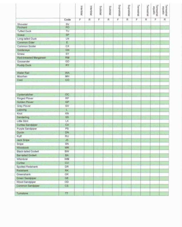

Low tide waterbird surveys: survey methods and guidance
                             notes

                             Lesley J. Lewis1 and T. David Tierney2

     1   BirdWatch Ireland, Unit 21, Block D, Bullford Business Campus, Kilcoole, Co Wicklow.
                                       www.birdwatchireland.ie

National Parks & Wildlife Service, Department of Arts, Heritage and the Gaeltacht, 7 Ely Place,
2

                                        Dublin 2. www.npws.ie

Citation:

Lewis, L. J. & Tierney, T. D. (2014) Low tide waterbird surveys: survey methods and guidance

notes. Irish Wildlife Manuals, No. 80. National Parks and Wildlife Service, Department of Arts,

Heritage and the Gaeltacht, Ireland.

Keywords: coastal Special Protection Areas, estuaries and intertidal flats, waterbirds, wading birds,

low tide surveys, distribution.

Site list: 4026, 4013, 4006, 4024, 4028, 4022, 4015, 4029, 4023, 4016, 4031, 4027, 4020, 4032, 4030, 4025,

4033, 4035, 4080, 4034, 4036, 4087, 4151, 4077, 4158, 4037, 4081, 4075, 4219, 4076, 4019, 4182, 4188.

Cover photo: Fergus Estuary © L.J. Lewis

         The NPWS Project Officer for this report was: David Tierney; david.tierney@ahg.gov.ie

                      Irish Wildlife Manuals Series Editors: F. Marnell & R. Jeffrey

                              © National Parks and Wildlife Service 2014

                                            ISSN 1393 – 6670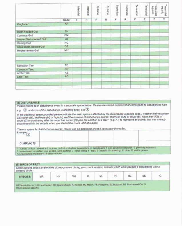

Low tide waterbird survey methods
____________________________

Contents

Executive Summary ........................................................................................................................................ 3

Acknowledgements ........................................................................................................................................ 4

1.0 Introduction ............................................................................................................................................... 5

   1.1 Waterbird surveys in Ireland .............................................................................................................. 5

   1.2 The need for a low tide waterbird survey programme.................................................................... 6

2.0 Background to the low tide survey programme ................................................................................... 7

   2.1 Survey coverage of coastal SPAs ........................................................................................................ 7

   2.2 Species coverage .................................................................................................................................... 7

   2.3 Fieldworkers .......................................................................................................................................... 8

   2.4 The survey programme ........................................................................................................................ 8

3.0 Survey methodology ................................................................................................................................ 9

   3.1 Survey planning and site/subsite determination .............................................................................. 9

   3.2 Field survey methods ......................................................................................................................... 10

       Pre-survey .............................................................................................................................................. 10

       Bird Counts ............................................................................................................................................ 11

       Mapping flock positions ...................................................................................................................... 12

       Recording accessory information ....................................................................................................... 13

4.0 Data handling and use ........................................................................................................................... 16

   4.1 SPA Conservation Objectives ............................................................................................................ 16

       How the data are handled ................................................................................................................... 16

       GIS mapping .......................................................................................................................................... 16

       Low tide data analyses and presentation .......................................................................................... 16

   4.2 Data interpretation, limitations and guidance notes ...................................................................... 18

5.0 Bibliography & Relevant Literature ..................................................................................................... 20

Appendices .................................................................................................................................................... 21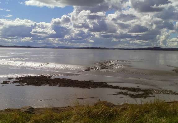
Low tide waterbird survey methods
____________________________

  Appendix 1 ................................................................................................................................................ 21

  Appendix 2 ................................................................................................................................................ 22

  Appendix 3 ................................................................................................................................................ 26

  Appendix 4 ................................................................................................................................................ 29

  Appendix 5 ................................................................................................................................................ 32

  Appendix 6 ................................................................................................................................................ 35

  Appendix 7 ................................................................................................................................................ 36
Low tide waterbird survey methods
____________________________

Executive Summary

Ireland’s coastal wetlands support thousands of migratory waterbirds each winter that either use

them as wintering grounds or as stop-over places along migratory pathways to wintering areas

further south. The conservation value of Ireland’s coastal wetlands is informed through regular

waterbird monitoring. Data collected though the Irish Wetland Bird Survey (I-WeBS) enables the

production of waterbird population estimates and trends at the site level and at the national level.

I-WeBS surveys are undertaken primarily on a rising tide, when birds, being pushed closer to shore by

the rising water or gathering at roost sites, are easier to count. As a primary focus of waterbirds

during winter is to feed, it is therefore important to understand how waterbirds are distributed across

a site when they are feeding. For many species feeding is concentrated around the low water stage of

the tidal cycle, when tidal flats are exposed. The collection and analyses of low tide data, in addition

to I-WeBS data, therefore promotes a better understanding of how these species use sites, and are

important in informing the conservation management of these important areas.

The National Parks and Wildlife Service (NPWS) of the Department of Arts, Heritage and the

Gaeltacht undertook a programme of low tide waterbird surveys across 33 coastal Special Protection

Areas (SPAs) over the three winters of 2009/10, 2010/11 and 2011/12. The resulting low tide data are

currently presented within SPA Conservation Objectives Supporting Documents and summary data

are available from NPWS, on request.

This report presents the methodology used to collect these low tide data and gives guidance on data

interpretation and use. It is intended that the information presented here on low tide survey design

and its execution will inform future survey work on non-breeding waterbirds at coastal sites in

Ireland.

                                                                                                   3
Low tide waterbird survey methods
____________________________
Acknowledgements
Fieldwork for the three seasons of the low tide waterbird survey programme (2009/10, 2010/11 and
2011/12) was largely completed by staff and contractors of BirdWatch Ireland under contract to the
National Parks & Wildlife Service. Large-scale surveys of this nature involve a great deal of hard
work and dedication, often in inclement weather conditions, and we extend sincere thanks to all
fieldworkers, both BWI contractors and NPWS Conservation Rangers, that were involved in these
surveys and especially to Sinead Cummins (BWI), who coordinated the programme across the three
seasons.
The authors extend thanks to Olivia Crowe and Helen Boland of the I-WeBS Office for their input to
survey methodology, and are grateful for their review and comments on the draft version of these
guidelines.
4Low tide waterbird survey methods
____________________________
1.0 Introduction
In the winter of 2009/10, the National Parks and Wildlife Service (NPWS) initiated a programme of
low tide waterbird surveys across a series of coastal Special Protection Areas (SPAs). In 2009/10, and
the following two winters (2010/11 and 2011/12), these surveys were undertaken across a total of 33
coastal SPAs. The primary aim of the surveys was to gain an understanding of how waterbird species
use these sites during the low tide period and to identify important foraging areas; key information
that was often lacking previously for some of these wetland sites.
The analyses of data from the NPWS low tide Waterbird Survey Programme 2009 – 12 are presented
within the various SPA Conservation Objectives Supporting Documents and summary data are
available from NPWS on request. This report presents the methodology used to collect these low tide
data and gives guidance on data interpretation and use. It is intended that the information presented
here on low tide survey design and its execution will inform future survey work on non-breeding
waterbirds at coastal sites in Ireland.
1.1 Waterbird surveys in Ireland
Ireland’s coastal wetlands1 are important for thousands of migratory waterbirds that either use them
as wintering grounds or as stop-over places as they journey to wintering grounds further south. The
majority of these birds have spent the summer months at arctic and boreal breeding grounds and
migrate south in autumn to avail of the relatively mild and ice-free conditions at our estuaries and
coastal bays and to exploit the abundant prey resource that these habitats support.
The importance of Ireland’s coastal and inland wetlands for non-breeding waterbirds has long been
recognised. Waterbird surveys over limited years were carried out in Ireland during the decades
1940s to 1980s (see a review in Crowe, 2005). Since the winter of 1994/95 an annual waterbird
monitoring scheme has been established, which is known as the Irish Wetland Bird Survey (I-WeBS).
The primary aim of I-WeBS is to monitor the numbers and distribution of non-breeding waterbird
populations during winter. The data collected have been used to provide the basis for site selection
and designation of SPAs, and have enabled the estimation of population size and trends of many
waterbird species to be calculated.
1It should be acknowledged that inland (non-coastal) wetlands also contribute to the total wetland resource utilised by
migratory waterbirds each winter, but this document relates specifically to coastal wetland sites.
5Low tide waterbird survey methods
____________________________
1.2 The need for a low tide waterbird survey programme
I-WeBS Core counts are undertaken at monthly intervals during the period September – March
inclusive (for further details please refer to Crowe, 2005; Boland & Crowe, 2012). This timeframe
covers the main winter period when many species occur in their largest concentrations, but also
overlaps with the autumn and spring passage periods when total waterbird numbers at sites may be
enhanced by staging/stopover birds2.
I-WeBS surveys are undertaken primarily on a rising tide, when birds are pushed closer to shore and
are easier to count. At high tide, I-WeBS can also record the positions of roost sites and the numbers
and species of waterbirds that use them.
During the non-breeding period, waterbirds must achieve a sufficient energy intake through feeding
in order to reduce the risks of overwinter mortality but also to enable the successful return migration
to the breeding grounds in good condition to breed. Therefore it is important to understand how
waterbirds are distributed across a site when they are feeding, and for many species feeding is
concentrated around the low water stage of the tidal cycle, when tidal flats are exposed. Detailed
knowledge of low tide feeding grounds and their use, in addition to I-WeBS data, therefore provide a
more complete understanding of how species use sites, which is important to inform the conservation
management of these important areas.
2 The terms ‘stopover’ and ‘staging’ are often used interchangeably. A stopover site can be defined as any place where a bird
takes a break during migration. Staging areas are stopover sites that attract large numbers of individuals and play an important
part in re-fuelling the birds before their onward migration (e.g. Warnock, 2010).
6Low tide waterbird survey methods
____________________________
2.0 Background to the low tide survey programme
2.1 Survey coverage of coastal SPA s
The NPWS low tide Waterbird Survey Programme commenced in the season 2009/10. By the end of
the winter 2011/12, thirty-three coastal SPAs were surveyed across Ireland. A list of sites surveyed to
date is provided in Appendix 1.
The primary focus during low tide surveys was often on wading birds that specialise in feeding across
exposed tidal flats. But coastal SPAs are often ‘site complexes’ and may cover large areas and include
a range of intertidal and coastal habitats across which waterbirds may range, including saltmarsh,
coastal grassland, lagoons, reedswamps and freshwater lakes. Therefore the waterbird survey
programme often extended beyond the SPA boundaries and included other associated wetland areas.
Complete coverage of wetlands was achieved for a majority of sites with some notable exceptions; an
example being the River Shannon & Fergus Estuaries SPA (Site code 4077) which at 32,261ha in size, is
not only challenging in terms of accessibility, visibility and the distances over which birds range, but
also in terms of the time and number of fieldworkers that would be required to achieve full count
coverage. For such sites the primary aim was therefore to complete good count coverage across key
areas of the site.
A single wetland site can rarely meet all the ecological requirements of a diverse assemblage of
waterbirds (Ma et al. 2010); so while a count site may satisfy the ecological requirements (e.g. feeding,
roosting, loafing) for some species, it may not for others. To address this monitoring issue, a series of
additional surveys are undertaken periodically to complement I-WeBS; these are discussed in Crowe
(2005) and Boland & Crowe (2012).
2.2 Species coverage
Waterbirds are defined as ‘’birds that are ecologically dependent on wetlands’’ (Ramsar Convention, 1971).
Although linked by their dependence on water, different species can vary considerably in aspects of
their ecology due to many evolutionary adaptations and specialisations to different wetland habitats.
Species or groups of species may therefore utilise wetland habitats in very different ways which
relates to how species are distributed across a site as a whole.
The following waterbirds as defined by the Ramsar Convention (1971) were included in the survey
programme: Gaviidae (divers), Podicipedidae (grebes), Anatidae (swans, geese and ducks), Rallidae
7Low tide waterbird survey methods
____________________________
(Water Rail, Moorhen & Coot), Haematopodidae (oystercatchers), Charadriidae (plovers and
lapwings), Scolopacidae (sandpipers and allies) and Laridae (gulls and terns). In line with I-WeBS
methodology, Cormorant (Phalacrocorax carbo), Shag (Phalacrocorax aristotelis), Little Egret (Egretta
garzetta), Grey Heron (Ardea cinerea) and Kingfisher (Alcedo atthis) were also included.
2.3 Fieldworkers
Fieldwork for the three survey seasons was primarily undertaken by staff of BirdWatch Ireland under
contract to the National Parks & Wildlife Service. Teams of fieldworkers were assigned to each site
and an overall Team Leader was appointed to coordinate the teams and data entry, data storage/filing
and delivery. Low tide surveys at several sites were completed by the regional staff of NPWS.
2.4 The survey programme
To maximise data collection, four low tide counts were completed each season. A single low-tide
count was undertaken in each of the months October, November, December and February. It was
recommended that no count should be undertaken within ten days of a previous count.
Low tide surveys were standardised by being undertaken during the two-hour period either side of
low-tide. In a semi-diurnal system, each low tide cycle lasts approximately six hours, and an estuarine
system is constantly in flux as the tide ebbs slowly towards the time of low water, and then floods
gradually to the time of high water. While it is recognised that waterbird distribution varies across
the tidal cycle, and like the tidal cycle itself, is constantly in flux, previous studies suggest that
standardisation of counts to the period before and after low tide provides a good representation of the
average usage of study areas in 75% of cases (Burton et al. 2004).
Clearly ‘through-the-tide counts’ would be advantageous to obtain the most complete understanding
of foraging distribution across a site but these were beyond the scope of this broad-scale monitoring
programme. However such approaches would be very useful for detailed studies as part of, for
example, ecological impact assessments (EcIA).
8Low tide waterbird survey methods
____________________________
3.0 Survey methodology
3.1 Survey planning and site/subsite determination
As noted above, a key requirement of the survey programme was to achieve, wherever practicable,
count coverage of each wetland site in its entirety. Therefore an important early step in survey
planning is to define the total extent of the wetland site and the total count area of that site (i.e. the
area that can be covered practicably). The total count area is then divided into subsites. The
publication Ireland’s Wetlands and their waterbirds: status and distribution (Crowe, 2005) is a key reference
containing site descriptions and details of I-WeBS boundaries and coverage, while SPA boundaries are
available to view and download on www.npws.ie.
The identification of count subsites should begin with a review of I-WeBS boundaries because these
are defined with mapped boundaries and known and workable vantage points. The use of I-WeBS
subsites also enables comparison of low tide data with I-WeBS data. However, as I-WeBS is
undertaken on a rising or at high tide, the subsites are sometimes inappropriate for the low-tide
programme when a larger area of tidal flat is exposed. The subdivision of I-WeBS subsites is therefore
recommended, leaving the outer boundaries intact to allow comparison of data collected with existing
datasets. Subsites are subdivided using identifiable features (e.g. man-made features such as piers,
slips or roads) and using natural divisions between habitat types (e.g. upper estuarine mudflats, outer
estuarine sandflats, open sea). A site visit is necessary to confirm subsite boundaries; this is
undertaken during the low tide period when all broad habitats can be viewed. Count subsites are
chosen on the basis that:
(1) complete coverage by n number of fieldworkers is possible within a four-hour period;
(2) there is no overlap of areas counted and no areas were missed;
(3) they are appropriate (in terms of size/habitat type etc) for low-tide surveys (see above);
(4) they can be clearly identified in the field and on a 6-inch map (to allow accurate
digitisation within GIS); and
(5) they are repeatable.
For the 33 SPAs covered, low tide site boundaries and subsite boundaries have been determined and
digitised within ARC GIS. These boundaries can be used in future low tide monitoring programmes
and subsite boundary shapefiles are available on request from NPWS.
9Low tide waterbird survey methods
____________________________
Wherever possible, survey dates should be chosen so that the time of low tide (or high tide) is close to
midday thus maximising the time available before and after the survey period, facilitating fieldworker
travel, and access to and from vantage points in daylight. Flexibility with regards survey dates is
required to be able to respond to weather conditions therefore the identification of ‘back-up’ dates is
advisable.
3.2 Field survey methods
Pre-survey
Each fieldworker was assigned a number of count subsites for which they are responsible during the
survey programme. Repeat counts by the same fieldworker are advantageous so that they become
familiar with access routes between vantage points as well as boundary lines between subsites. Repeat
surveys by the same person also maximises knowledge gained of bird behaviour, patterns and
distribution in their survey areas.
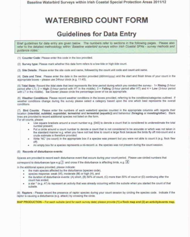
Fieldworkers were provided with field maps (Ordnance Survey Ireland (OSI) 6’’or 1:5000 maps)
showing subsite boundaries plus count forms for recording count data (shown in Appendix 2). Aerial
photographs with subsite boundaries superimposed may also be useful. Target Note Sheets are used
for the recording of additional observations as required. In practice, hand-written count forms have
become almost obsolete because Excel data entry is quicker. Fieldworkers record count data using a
method familiar to them (e.g. field notebook) and transfer these data to the Excel data entry sheet after
the survey. Printed count forms remain useful however as a check-list in the field providing summary
instructions on the various categories of data that need to be recorded.
Before starting a count, the following data is recorded for each subsite:
1. Counter Code: a unique code assigned to each fieldworker.
2. Survey type: i.e. low tide.
3. Site/Subsite Details: the code and name of the site and subsite being counted.
4. Date and count start and end time.
5. Tidal State: as per the following categories 1= Rising (3-hour period after LT); 2 = High (3-
hour period with HT in the middle); 3 = Falling (3-hour period after HT) and 4=Low (3-hour
period with LT in the middle).
6. Ice Cover: this refers to areas of frozen mudflat, saltmarsh or even frozen sea surface and
was recorded in the following categories 0-33%, 33-66% and 66-100%.
10Low tide waterbird survey methods
____________________________
7. Weather Conditions: attributed to the following categories: cloud cover (0-33%, 33-66% and
66-100%), rain (none, showers or drizzle), wind (calm, light or breezy) and visibility (good, moderate
or poor).
Note that poor weather conditions can seriously affect visibility and the accuracy of counts. Surveys
should therefore not proceed in conditions of heavy rain, poor visibility or strong wind. Despite
surveys being planned for days with suitable weather, conditions can sometimes deteriorate during a
survey. In extreme cases surveys may need to be abandoned and re-scheduled.
Bird Counts
Waterbird counts are conducted on the ‘look-see’ basis (Bibby et al. 2000) which involves scanning
across the survey area and counting all birds seen. Birds are recorded (and listed on the count form)
according to their species code following the two-letter coding system used by I-WeBS and developed
by the British Trust for Ornithology. The codes for common species are shown in Appendix 3.
The position and behaviour of the birds counted is assigned to the categories outlined below:
Position - waterbirds are assigned to one of five broad habitats (1) intertidal (area between mean low
water and mean high water); (2) subtidal (area below mean low water) (3) supratidal (area above
mean high water); (4) terrestrial and (5) terrestrial – aquatic. Further guidance on the use of these
broad habitats is given in Appendix 4.
Only waterbirds that occur within count subsites are recorded in the standard manner. However, as
with any mobile species, waterbirds sometimes occur outside of the delineated subsites (e.g. flocks
feeding in nearby fields). In these cases it is advantageous to record this information on additional
datasheets or using the Target Note Sheet.
Behaviour – waterbird behaviour is assigned to one of two categories: (1) foraging or (2)
roosting/other. Further guidance on this topic is given in Appendix 5.
Recording numbers of waterbirds and count accuracy - count accuracy should be recorded as
follows:
Count number only - denotes that a count is considered accurate to within 10% of the total
number present;
Count number in square brackets e.g. [540] - denotes a count that is an underestimation of the
total number present;
Count number within a circle - denotes a count that is not considered accurate or has not been
obtained in the standard manner (e.g. a crude estimate when birds fly off mid-count);
11Low tide waterbird survey methods
____________________________
‘NC’ (no count) written in the appropriate species box - indicates that a species is present but is
not counted for some reason (e.g. flock flew off just as you were about to count it).
Mapping flock positions
In addition to counting waterbirds within subsites, the position of major flocks of foraging and/or
roosting birds is drawn onto field maps (‘flock maps’). The interpretation of what is a ‘major’ flocks is
subjective and best judgement is used to determine which flocks to map (e.g. the difference between a
flock of 10 Wigeon and 10 Greenshank; with the latter being more significant).
Species that are widely distributed as many small flocks, or are widely dispersed across a subsite are
difficult to map and in these cases a simple written note onto a flock map or Target Note Sheet can aid
the understanding of distribution at a later date. Appendix 6 shows some examples of flock maps.
Flock positions are recorded by drawing a shape onto the field map that illustrates the estimated
location and extent of the flock. The species (codes), their numbers and an indication of behaviour
(foraging (F) or roosting/other (R) are written inside or alongside the shape, clearly linked with an
arrow.
For example: a flock of roosting Golden Plover upon sandflats at low-tide:-
GP R 1,500
GP R 1,500
A mixed flock of 980 foraging Black-tailed Godwits and 50 foraging Dunlin - counts for both species
are considered to underestimate the true flock size:-
BW F [980]
DN F [50]
BW F [980]
DN F [50]
When it was not clear on the field map as to which broad habitat the birds are in (e.g. intertidal vs
subtidal) then the broad habitat (Int, Sub, Supra, Terr or Terr (aq) as appropriate) should also be
written alongside the species code and number. Flocks that occur across two different broad habitats
are labelled with both (e.g. Int/Sub).
12Low tide waterbird survey methods
____________________________
Overlapping count sections: when a flock occurs on the boundaries of separate count subsites then
only birds that occur inside the subsite being counted are recorded. However it is useful to note on
the field map or Target Note Sheet that the flock overlaps with another subsite.
Subsite WN R 320
boundary T. R 180
MA R 150
Overlapping flocks: when it is possible to distinguish two distinct flocks that overlap each other they
can be mapped to indicate this. The example below shows a flock of roosting Black-tailed Godwits
and Knot, where the Knot are located in a linear strip overlapping the Black-tailed Godwits. (Note that
the Knot are distributed across both intertidal and subtidal habitat i.e. some birds have their feet in
water although it is not possible to make an accurate count of each so a total count is given).
BW R 180 (Int)
KN R 220
(Int/Sub)
Disturbed flocks: if a flock flies away prior to its mapping, where possible the flock position and
number of birds are estimated (circled number to denote inaccurate).
Moving flocks: some flocks of birds regularly take to the air and then settle again in a slightly
different position. These movements can be recorded by marking the general position of the flock and
indicating its transient nature on the Target Note Sheet. If necessary, map several positions and link
them with an arrow.
Recording accessory information
Fieldworkers spend a considerable amount of time in the field and the recording of accessory
information is advantageous, especially when this information can aid the understanding of the
distribution or behaviour of the waterbirds present.
13Low tide waterbird survey methods
____________________________
Recording of activities/events: this refers to activities that occur at the site that are, or have the
potential to cause disturbance to waterbirds. All activities are recorded, regardless of whether they
are causing a noticeable disturbance to birds at the time of observation, or not. Each activity is
recorded separately. Although the method of recording appears complex it is easily accomplished in
practice.
A circled number is used to identify the activity type and this number is crossed if the activity is
affecting birds. Activity types are categorized as follows:
(1) human, on-foot - shoreline (2) human, on foot – intertidal aquaculture, (3) bait-diggers (4) non-
powered watercraft (5) powered watercraft, (6) water-based recreation (e.g. wind-surfers) (7) horse-
riding (8) dogs (9) aircraft (10) shooting (11) other (12) winkle pickers (13) aquaculture machinery (14)
other vehicles.
Note that (8) dogs, refers to dogs with or without accompanying humans, to distinguish between
humans that are walking along a shore without dogs (1).
The circled number is recorded onto the count form/data sheet and onto a field map. In the case of the
latter, the circled number is drawn to show the general location of the activity and the map can also be
annotated to indicate e.g. routes traversed by boats or people.
When an activity is observed to cause a disturbance, the waterbird species affected are recorded by
writing the species code in the space provided on the count form/data sheet. In brackets following the
species code, a letter is used to indicate the bird’s response to the activity as follows:-
W - Weak response, waterbirds move slightly away from the source of the disturbance.
M - Moderate response, waterbirds move away from the source of the disturbance to another part of
your subsite; they may return to their original position once the activity ceases.
H - High response, waterbirds fly away to areas outside of your subsite and do not return during the
current count session.
The length of the activity is recorded by adding by the codes A – D (see below). The addition of a star
* (e.g. A*) represents an activity that was already occurring within the subsite when the count started.
A – short/discrete event.
B – activity occurs for up to 50% of the count period.
C – activity length estimated at >50% but < 100% of the count period.
D – activity continues after the count period has ended.
14Low tide waterbird survey methods
____________________________
Best judgement should be used when recording activities. Although it is important to record
individual activities and how waterbirds respond to them, individual detail is not always needed. For
example, several people walking along a beach with their dogs can be recorded as one event if it
occurs in the same general location. Likewise, several small fishing boats in one area of a harbour can
be counted as one event; but if one boat takes a different path across a new area then this would be
recorded separately.
Recording the presence of raptors - the presence of raptors during a count session is recorded by
circling the species code on the count form. A crossed circle represents a raptor that is causing
disturbance to waterbirds. Alternatively this data is entered into the data sheet.
15Low tide waterbird survey methods
____________________________
4.0 Data handling and use
4.1 SPA Conservation Objectives
Low tide data from the NPWS low tide Waterbird Survey Programme 2009 – 12 are analysed and
presented within the various SPA Conservation Objectives Supporting Documents (see examples on
www.npws.ie).
How the data are handled
Raw data are received from fieldworkers either on count forms or, for the majority, on specifically
designed MS Excel data sheets. Data are compiled and quality checked then entered into an MS
Access database, from which summary datasheets can be produced.
For each survey undertaken and for each species, subsite totals are obtained by summing the
individuals counted across each behaviour and broad habitat type within each subsite. When a
subsite was counted by more than one fieldworker, (e.g. large subsites that required fieldworkers at
more than one vantage point), the count data are added together to form a total subsite count.
GIS mapping
Low tide site boundaries and subsite boundaries are mapped within GIS. This allows the
determination of site and subsite areas. Broad habitats are mapped using OSI Discovery Series
mapping and the areas of broad habitats determined at site and subsite level.
Low tide data analyses and presentation
The aim of data analyses is to help understand how waterbirds are distributed across a site during the
survey period. By assessing patterns of waterbird distribution at low tide, together with examination
of data on sediment and invertebrate distribution and abundance 3, areas (subsites) within the site that
are important for foraging (and roosting) are identified on a species by species basis.
For each coastal SPA site, data analyses determine the proportional use of subsites by each species
relative to the whole area surveyed on each survey occasion. These analyses are undertaken for total
bird numbers, and for subsets of these data, for example, species foraging (intertidally or subtidally).
For each survey date, subsites are ranked in succession from the highest to the lowest in terms of their
3 Data from surveys undertaken by NPWS and the Marine Institute.
16Low tide waterbird survey methods
____________________________
relative contribution to each species’ distribution. The rank positions are then converted to categories
as follows:
Very High (V) - Any section ranked as 1.
High - Top third of ranking placings (where n = total number of count sections species was
observed in);
Moderate (M) - Mid third of ranking placings (where n = total number of count sections species
was observed in)
Low (L) - Lower third of ranking placings (where n = total number of count sections species was
observed in).
This approach, rather than averaging across all surveys, means that more than one subsite can be
ranked within the same category. This equal weighting allows for temporal differences e.g.
concentrations of foraging birds in different subsites at different times, reflecting natural pattern of
distribution across time.
Intertidal foraging density is calculated for selected species and for each low tide survey, by dividing
the number of the species within a subsite by the area of intertidal habitat within the same subsite.
Whole site intertidal foraging density is calculated by summing the mean subsite counts for each
species and dividing by the total area of intertidal habitat within the count area.
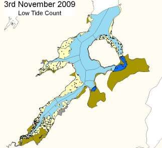
Waterbird count data for low tide surveys are also
presented as species distribution maps (‘dot density
maps’). Dot-density maps show waterbird species
distribution, divided into ‘foraging’ birds and
‘roosting/other’ birds, an example shown in Figure
1. The abundances of birds are represented by dots;
each dot representing one, or a pre-determined
number of birds. As the dots are randomly placed
within the appropriate subsites and broad habitat
types for the birds counted, the resulting map
presents numbers and densities in an efficient and
effective manner in order to assess a species’
distribution. Figure 1. Example dot density map
Summary low tide data are available on request from NPWS, and take the form of totals (e.g. site
totals, subsite totals) and summaries (e.g. data divided by behaviour or position).
17Low tide waterbird survey methods
____________________________
4.2 Data interpretation, limitations and guidance notes
While low tide data can provide important information on the distribution of waterbirds during the
low tide period, there are several points to consider when interpreting these data.
Based on previous experience (e.g. Musgrove et al. 2003; Lewis & Kelly, 2012), it is considered that
broad-scale low tide distributions recorded in a single winter are a reasonably reliable predictor of
longer-term distributions, so long as major changes do not take place such as marked shifts in
invertebrate distribution/abundance or increases in external pressures (e.g. human activities).
However each site should be considered on an individual basis because some sites have more external
pressures that might affect waterbird distributional patterns, than others.
In order to assess species’ distribution over time, repeat surveys using similar methods and count sites
would be required (e.g. Lewis & Kelly, 2012).
A species’ distribution at a point in time may be influenced by one or more factors. A notable example
is weather. The NPWS low tide Waterbird Survey Programme 2009 – 12 coincided with two relatively
severe cold winters (i.e. 2009/10 and 2010/11) which undoubtedly affected waterbird distribution
patterns across Ireland and Europe (Crowe & Boland, 2011). Other influencing factors include tide
(e.g. differences in exposure of tidal flats between spring and neap tides), temperature, direction of
prevailing winds, changing prey densities/availabilities and degree of human activity across the site,
all of which could lead to changing patterns across months and years.
As described previously, low tide surveys are standardised by being undertaken during the period
two hours before, to two hours after, the time of low water. While this period provides a good
representation of the average usage of study areas (Burton et al. 2004) it should be recognised that
waterbird feeding distribution changes throughout the tidal cycle. For example, low tide counts are
likely to underestimate the usage of upper shore areas, these areas often utilised for a brief but
important period as the tide ebbs. Low tide surveys are ideally suited to collecting data on the
distribution of wading birds. While all waterbird species were counted during the NPWS low tide
survey programme, it should be borne in mind that other states of the tide may be more appropriate
for some other species, and notably waterfowl that forage preferentially on ebbing or flood tides.
While the low tide survey period is deemed suitable for broad-scale surveys, in some cases, and where
specific detail is required, ‘through the tide counts’ may need to be employed.
Dot-density maps do not show the actual position of birds; the dots are placed randomly within
subsites so no conclusions can be made at a scale finer than subsite. Although the dots are placed in
the appropriate subsites and broad habitats for the birds counted, the broad habitats are based on OSI
mapping, and cannot represent the finer-scale habitat complexities that occur across a site, for
18Low tide waterbird survey methods
____________________________
example, in the case of waterbirds associated with freshwater flows, or small creeks, that are ‘subtidal’
in terms of broad habitat definition, but are not shown on OSI maps.
While field maps (flock position maps or roost location maps) can be very valuable in clarifying
details of finer-scale distribution, some limitations of use apply. In general it is very difficult to
accurately determine the position of birds when viewing over large distances; the inherent error in
this will vary for different sites. Flock or roost position maps are best viewed as indicative only.
The NPWS low tide Waterbird Survey Programme 2009 – 12 was based on surveys that were largely
undertaken during the days Monday to Friday. In many sites the levels of human recreational
activities are much reduced on weekdays as opposed to weekend days, and hence waterbird
distribution may differ between them. The significance of this will vary on a site by site basis.
Additional pointers are given below to guide the careful use of low tide (and other) waterbird data.
I-WeBS is the principal source of data that inform the calculation of population estimates both
at site level and national level. Analyses of I-WeBS data also lead to the production of trends
of waterbird numbers and distribution. Low tide data surveys are primarily intended to
provide details of waterbird spatial distribution. As already noted above however, these
patterns of distribution should not be considered absolute as waterbirds by their nature are
highly mobile and various factors will lead to variation across both space and time.
I-WeBS data are generally examined in five-year periods (five-year peak mean). The mean is
used to dampen annual fluctuations in numbers, and as a way of compensating for missing
counts (Boland & Crowe, 2012). It is important to consider that low tide data at the site level
from the NPWS low tide Waterbird Survey Programme 2009 – 12 refers to one single season.
When examining this limited dataset, site and subsite peak numbers, rather than average
numbers, are therefore most appropriate for use because they give a better reflection of the
totals of birds using the area.
Density is an important calculation as seemingly low numbers of birds in an area can,
depending on area counted, equate to a high density area of particular significance.
Data for individual subsites should not be considered in isolation. As subsites are subdivided
units of the ‘entire’ wetland, subsite data should always be viewed in the context of the site as
a whole.
It should be borne in mind that the standard low tide survey programme encompassing the
months October to February inclusive, does not provide any detail on birds that may occur at
a site during the important periods of passage (i.e. August- September, March-April).
19Low tide waterbird survey methods
____________________________
5.0 Bibliography & Relevant Literature
Bibby, C. J., Burgess, N. D., Hill, D. A. & Mustoe, S. H. (2000). Bird Census Techniques. Academic Press.
Boland, H. and Crowe, O. (2012) Irish wetland bird survey: waterbird status and distribution 2001/02 –
2008/09. BirdWatch Ireland, Kilcoole, Co. Wicklow.
Burton, N.H.K., Musgrove, A. J. & Rehfisch, M. M. (2004) Tidal variation in numbers of waterbirds:
how frequently should birds be counted to detect change and do low tide counts provide a
realistic average? Bird Study 51: 48-58.
Crowe, O. (2005) Ireland’s Wetlands and their waterbirds: status and distribution. BirdWatch Ireland.
Crowe, O., Boland, H. & Walsh, A. (2011) Irish wetland bird survey: results of waterbird monitoring in
Ireland 2009/10. Irish Birds 9: 229-240.
DoEHLG, (2009) Guidance Document ‘Appropriate Assessment of plans and projects in Ireland: Guidance for
planning authorities. Department of the Environment, Heritage & Local Government. 2009.
Fossitt, J.A. (2000) A Guide to the Habitats of Ireland. The Heritage Council, Ireland.
I-WeBS (2008) Counter Manual: Guidelines for Irish Wetland Bird Survey Counters. BirdWatch
Ireland.
Lewis, L. J. & Kelly, T. C. (2012) Aspects of the spatial ecology of waders along an estuarine gradient.
Irish Birds 9: 375-384.
Ma, Z., Cai Y., Li, B. & Chen, J. (2010) Managing Wetland Habitats for Waterbirds: An International
Perspective. Wetlands 30: 15-27.
Musgrove, A., Langston, R., Baker, H. & Ward, R. (2003) Estuarine waterbirds at low tide. The WeBS Low
Tide Counts 1992-93 to 1998-99. WSG/BTO/WWT/RSPB/JNCC, Thetford, UK.
Vorisek, P., Klvanova, A., Wotton, S. & Gregory, R. D. (2008) A best practice guide for wild bird
monitoring schemes. CSO/RSPB.
Warnock, N. (2010) Stopping vs. staging: the difference between a hop and jump. Journal of Avian
Biology 41: 621-626.
Wetlands International (2005) Guidelines for participants in the International Waterbird Census (IWC),
January 2005.
20Low tide waterbird survey methods
____________________________
Appendices
Appendix 1
Coastal SPAs included in the NPWS low tide Waterbird Survey Programme 2009 – 12
2009/10 2010/11 2011/12
Dundalk Bay (Co Louth) (SPA Drumcliff Bay (Co Sligo) (SPA 4013) North Bull Island & South Dublin Bay
4026) & River Tolka Estuary (Co. Dublin)
(SPA 4006 & 4024)
Blackwater Estuary (Co Ballycotton Bay (Co Cork) (SPA Rogerstown Estuary (Co Dublin) (SPA
Waterford/Cork) (SPA 4028) 4022) 4015)
Castlemaine Harbour (Co Ballymacoda Bay (Co Cork) (SPA Baldoyle Bay (Co Dublin) (SPA 4016)
Kerry) (SPA 4029) 4023)
Inner Galway Bay (Co Galway) Tramore Bay (Co Waterford) (SPA Ballyteige Burrow (Co. Wexford)
(SPA 4031) 4027) (SPA 4020)
Dungarvan Harbour (CO Cork Harbour (SPA 4030) Malahide Estuary (Co Dublin) (SPA
Waterford) (SPA 4032) 4025)
Cumeen Strand (Co Sligo) (SPA
Bannow Bay (Co Wexford) Boyne Estuary (Co. Louth) (SPA 4080)
4035)
(SPA 4033)
Killala Bay/Moy Estuary (Co Sligo)
Trawbreaga Bay (CO Donegal) Lough Foyle (4087)
(SPA 4036)
(SPA 4034)
River Shannon & Fergus Estuaries
Donegal Bay (Co Donegal) River Nanny Estuary & Shore (Co.
(Co Clare, Limerick, Kerry) (SPA
(SPA 4151) Meath) (SPA 4158)
4077)
Clonakilty Bay (Co Cork) (SPA 4081)
Blacksod/Broadhaven Bay (Co
Mayo) (SPA 4037)
Courtmacsherry Estuary (Co Cork)
Lough Swilly (Co Donegal)
(SPA 4219)
(SPA 4075)
Mid Clare Coast (Co Clare) (SPA
Wexford Harbour, Slobs (incl.
4182)
The Raven SPA) (Co Wexford)
(SPA 4076 and 4019)
Tralee Bay Complex (Co Kerry)
(SPA 4188)
21Low tide waterbird survey methods
____________________________
Appendix 2
Example count form
22Low tide waterbird survey methods
____________________________
23Low tide waterbird survey methods
____________________________
24Low tide waterbird survey methods
____________________________
25Low tide waterbird survey methods
____________________________
Appendix 3
Waterbird Species Codes
(for additional waterbird species not shown here please refer to I-WeBS (2008))
AE Arctic Tern Sterna paradisaea
BY Barnacle Goose Branta leucopsis
BA Bar-tailed Godwit Limosa lapponica
BE Bean Goose Anser fabalis
BS Bewick’s Swan Cygnus columbianus
AS Black Swan Cygnus atratus
BH Black-headed Gull Chroicocephalus ridibundus
BN Black-necked Grebe Podiceps nigricollis
BW Black-tailed Godwit Limosa limosa
BV Black-throated Diver Gavia arctica
DB Brent Goose (dark-bellied) Branta bernicla bernicla
PB Brent Goose (Light-bellied) Branta bernicla hrotra
CG Canada Goose Branta canadensis
CM Common Gull Larus canus
CS Common Sandpiper Actitis hypoleucos
CX Common Scoter Melanitta nigra
CN Common Tern Sterna hirundo
CO Coot Fulica atra
CA Cormorant Phalacrocorax carbo
CU Curlew Numenius arquata
CV Curlew Sandpiper Calidris ferruginea
DN Dunlin Calidris alpina
E. Eider Somateria mollissima
GA Gadwall Anas strepera
GP Golden Plover Pluvialis apricaria
26Low tide waterbird survey methods
____________________________
GN Goldeneye Bucephala clangula
GD Goosander Mergus merganser
GB Great Black-backed Gull Larus marinus
GG Great Crested Grebe Podiceps cristatus
ND Great Northern Diver Gavia immer
NW Greenland White-fronted Goose Anser albifrons flavirostris
GK Greenshank Tringa nebularia
H. Grey Heron Ardea cinerea
GV Grey Plover Pluvialis squatarola
GJ Greylag Goose Anser anser
HG Herring Gull Larus argentatus
IG Iceland Gull Larus glaucoides
JS Jack Snipe Lymnocryptes minimus
KF Kingfisher Alcedo atthis
KN Knot Calidris canutus
L. Lapwing Vanellus vanellus
LB Lesser Black-backed Gull Larus fuscus
ET Little Egret Egretta garzetta
LG Little Grebe Tachybaptus ruficollis
LU Little Gull Hydrocoloeus minutus
AF Little Tern Sterna albifrons
MA Mallard Anas platyrhynchos
MU Mediterranean Gull Larus melanocephalus
MH Moorhen Gallinula chloropus
MS Mute Swan Cygnus olor
OC Oystercatcher Haematopus ostralegus
PG Pink-footed Goose Anser brachyrhynchus
PT Pintail Anas acuta
PO Pochard Aythya ferina
PS Purple Sandpiper Calidris maritima
27Low tide waterbird survey methods
____________________________
RM Red-breasted Merganser Mergus serrator
RH Red-throated Diver Gavia stellata
RK Redshank Tringa totanus
RP Ringed Plover Charadrius hiaticula
RS Roseate Tern Sterna dougallii
RY Ruddy Duck Oxyura jamaicensis
RU Ruff Philomachus pugnax
SS Sanderling Calidris alba
TE Sandwich Tern Sterna sandvicensis
SP Scaup Aythya marila
SU Shelduck Tadorna tadorna
SV Shoveler Anas clypeata
SY Smew Mergus albellus
SN Snipe Gallinago gallinago
NB Spoonbill Platalea leucorodia
DR Spotted Redshank Tringa erythropus
T. Teal Anas crecca
TU Tufted Duck Aythya fuligula
TT Turnstone Arenaria interpres
WA Water Rail Rallus aquaticus
WM Whimbrel Numenius phaeopus
WG White-fronted Goose Anser albifrons
WS Whooper Swan Cygnus Cygnus
WN Wigeon Anas penelope
WK Woodcock Scolopax rusticola
28Low tide waterbird survey methods
____________________________
Appendix 4
Further guidance on assigning waterbirds to ‘location’
Categories Troubleshooter
Intertidal Piers and jetties – parts of these structures will be covered at high water and
uncovered at low water. Because they are man-made, unnatural habitats and
Assigning waterbirds to the
linked to land, please record waterbirds that occur upon these structures within the
category ‘intertidal’ should be
‘terrestrial’ category.
relatively straightforward. This
category refers to the area Man-made structures - e.g. buoys/rafts if the structures are entirely surrounded by
uncovered by the tide and most intertidal habitat please record the waterbirds that are standing on them within the
likely dominated by mudflats intertidal category regardless of whether it is a low-tide or high-tide count.
and sandflats but it may also
Saltmarsh – in theory all saltmarshes are subject to some degree of tidal
include areas of rocky
inundation, the classification of upper and lower saltmarsh heavily dependent on
shoreline, areas of mixed
shore height and the associated degree of submersion. However for the purpose of
sediment and grave/pebbles or
assigning waterbird location and to facilitate field recording, saltmarsh that is
shingle and gravel shores.
contiguous with coastal habitats lying above should be assigned to the supratidal
category. However if discrete stands of e.g. Glassworts (Salicornia sp) or Common
Cord-grass Spartina sp. occur as patches surrounded by mud/sand flat then this can
be viewed as intertidal.
Algal mats – mats of green algae Sea Lettuce (Ulva sp.) (formerly classified as
Enteromorpha spp.) that occur on tidal flats should be included within the intertidal
category.
Mussel beds - should be included within this category.
Note the difference in birds wading in water - wading birds that are observed
wading through water at the incoming tide edge (during HT counts) should be
classed as intertidal as this habitat would be uncovered by the tide at low-tide.
Where water cover remains upon the mudflat surface during low-tide counts (e.g.
within shallow dips or depressions) is also classed as intertidal habitat. However,
birds wading in channels, creeks or the open sea during low-tide counts should be
recorded as within subtidal habitat.
29Low tide waterbird survey methods
____________________________
Subtidal Tidal rivers – the lower sections (estuarine) that occur within your count section
are included here. Also include freshwater streams, tidal channels and creeks that
The category ‘subtidal’ refers to
are found across intertidal habitats at low-tide.
areas that are covered by
seawater during your counts. Man-made structures - if the structures are entirely surrounded by subtidal habitat
During low-tide counts it will please record the waterbirds that are standing on them within the subtidal
include offshore water, tidal category. Structures may include buoys, rafts, poles/masts associated with e.g.
channels and creeks. aquaculture or shipping etc.
Supratidal Supratidal vs terrestrial? – the difference between these two is the marine
influence; whereas supratidal areas have a strong marine influence, terrestrial areas
The category ‘supratidal’
do not.
relates to the shore area and
habitats immediately above the Saltmarsh – included here, see explanation in intertidal section above.
high-tide mark. Unlike the
Reedbed – please include within the supratidal category if it occurs immediately
terrestrial category however,
above tidal flat habitat (e.g. in association with a tidal river and mudflats within an
the supratidal section is an
upper estuary). If separated from the intertidal/supratidal area then please regard
integral part of the shoreline.
as terrestrial (e.g. in association with a freshwater lagoon).
Terrestrial Machair and sand dunes - please include within this category.
The category ‘terrestrial’ should Reedbed – please include within the supratidal category if it occurs immediately
be used where birds are above tidal flat habitat (e.g. in association with a tidal river and mudflats within an
recorded within habitats close upper estuary). If separated from the intertidal area then please regard as
to the shoreline but which are terrestrial.
above the intertidal and
Piers and jetties – parts of these structures will be covered at high water and hence
supratidal levels. The terrestrial
uncovered at low water. Because they are man-made, unnatural habitats and
category is regarded as having
linked to land, please record waterbirds that occur upon these structures within the
no, or only a weak, coastal
‘terrestrial’ category.
influence. Examples include
coastal grassland and marsh
and agricultural grassland.
Terrestrial - Aquatic This category refers to non-marine water bodies that are included within the site
complex, predominantly lagoons/lakes because they are wholly or partially
separated from the sea. These may be freshwater or brackish in nature. This
category would also include Drainage ditches e.g. man-made wet channels/ditches
that discharge to an intertidal habitat (for example may occur within a coastal
marsh) but are non-tidal.
30Low tide waterbird survey methods
____________________________
If you are unsure as to the category to assign to observed waterbirds, use your best judgement to assign them to a given category and make a note
on your Target Note Sheet as to the species code, count number and brief description of habitat/area encountered. Please then discuss with the
Team Leader to obtain clarification before further surveys.
31Low tide waterbird survey methods
____________________________
Appendix 5
Guidance on assigning waterbird ‘behaviour’
Wherever possible waterbirds should also be recorded as either ‘feeding’ (F) or ‘roosting/other’ (R). These
categories are given for each habitat type. We recognise that distinguishing between different behaviours may be
difficult and that at some sites, and for a variety of reasons, this task may be difficult to achieve with sufficient
accuracy. However, we ask you to undertake this task wherever possible and for as many species as you can.
Please use your best judgement when assigning birds to behaviour; we do not expect you to spend long in the
decision-making process, but rather, to make a ‘snap-shot’ decision based on your best judgement at the time.
For instance, when counting a large flock, assigning each and every bird to a behavioural category may take too
long. So it will be sufficient to either mark behaviour based on your judgement as to the proportion of birds
within the two categories or, place all birds under the behavioural category that best describes what the majority
of birds are doing.
On the data sheet, when you count a species but do not assign its behaviour, please record the count number in
the foraging (F) column but underline the counts given. Where none of the species during your count were
assigned to behaviour, please record the count numbers in the foraging (F) column but circle the letter F at the top
of the columns used.
A section of a data sheet is given below as an example: Mallard and Teal were counted and assigned to location
and behaviour. In the case of Wigeon however, although counts were recorded for different habitats, behaviour
was not assigned so the counts were underlined.
Supratidal
Supratidal
Terrestrial
Terrestrial
Terrestrial
Terrestrial
Intertidal
Intertidal
Subtidal
Subtidal
aquatic
aquatic
Code F R F R F R F R F R
Wigeon WN 220 550
Gadwall GA
Teal T. 50 80
Mallard MA 160
32You can also read