Major Incidents Report 2018-19 - Department of Home Affairs - Australian Institute Disaster ...
←
→
Page content transcription
If your browser does not render page correctly, please read the page content below
Department of Home Affairs

Major Incidents
Report 2018–19
The Australian Institute for Disaster Resilience (AIDR) is a        Attribution
disaster resilience knowledge centre. We develop, maintain
and share knowledge and learning to support a disaster              Where material from this publication is used for any purpose,
resilient Australia. We work with government, communities,          it is to be attributed to the developer as follows: Source: Major
non-government organisations, not-for-profits, research             Incidents Report 2018-19 (AIDR 2019).
organisations, education partners and the private sector
to enhance disaster resilience through innovative thinking,         Contact
professional development and knowledge sharing.
                                                                    Enquiries regarding the content, licence and any use of this
AIDR is funded by the Australian Government Department of           document are welcome at:
Home Affairs through Emergency Management Australia. AIDR
is supported by its partners: the Australian Government, the        Australian Institute for Disaster Resilience
Australasian Fire and Emergency Service Authorities Council         370 Albert St, East Melbourne VIC 3002
(AFAC), the Bushfire & Natural Hazards Cooperative Research         Telephone: +61 (0)3 9419 2388
Centre and Australian Red Cross.                                    Email: enquiries@aidr.org.au

Published by the Australian Institute for Disaster Resilience
on behalf of Emergency Management Australia, Australian             Disclaimer
Government Department of Home Affairs.                              The Australian Institute for Disaster Resilience, in consultation
© Australian Institute for Disaster Resilience 2019                 with subject matter experts, exercises care in the compilation
                                                                    and drafting of this publication. However, the document
                                                                    and related graphics could include technical inaccuracies
                                                                    or typographical errors and the information may not be
                                                                    appropriate to all situations. In no event shall the Australian
                                                                    Institute for Disaster Resilience be liable for any damages
Copyright                                                           whatsoever, whether in an action of contract, negligence or
                                                                    other tortious action, arising out of or in connection with the
AIDR encourages the dissemination of information provided           use of or reliance on any of the information in this publication.
in this publication. AIDR owns the copyright for all material
contained in this publication unless otherwise noted.
Where this publication includes intellectual property with
copyright owned by third parties, AIDR has made all reasonable
efforts to clearly label material where the copyright is owned by
a third party. Wherever a third party holds copyright in material
presented in this publication, the copyright remains with that
party. Their permission is required to use the material.
All material presented in this publication is provided under a
Creative Commons Attribution 4.0 International Public License,
with the exception of:
▪▪   the Commonwealth Coat of Arms
▪▪   registered trademarks, including the Department of
     Home Affairs logo and the Australian Institute for Disaster
     Resilience logo
▪▪   materials specifically mentioned as not being provided
     under a Creative Commons Attribution 4.0 International
     Public License
▪▪   content supplied by third parties.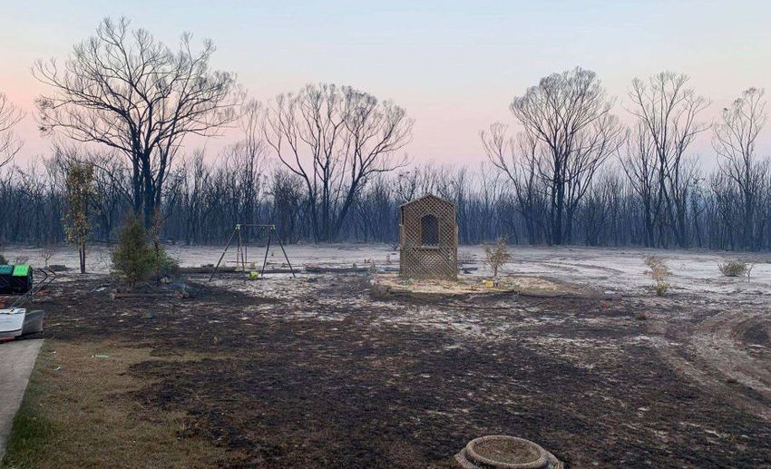
Disasters and disruptions provide an opportunity to learn. Distilling
the causes and sharing experiences of what contributed to each
disaster, providing evidence or unpicking what happened, all provide
important opportunities to learn so that measures can be taken to
reduce the chance of the same thing happening again.

Profiling Australia’s Vulnerability 2018
Australian Government Department of Home Affairs

                                                                        1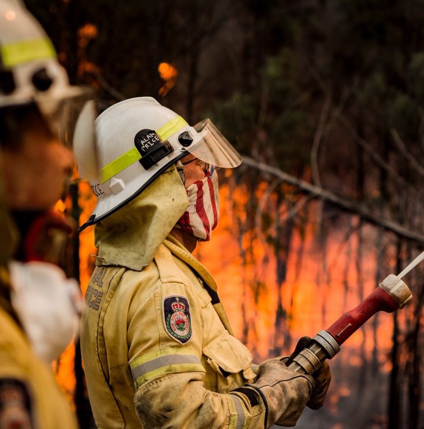
Foreword
                                                                    The Australian Institute for Disaster Resilience (AIDR)
This is the third annual Major Incidents
                                                                    acknowledges the contribution of Damien Killalea Consulting
Report published by the Australian Institute                        in the production of this report. AIDR also thanks all
for Disaster Resilience. This edition provides                      contributing agencies and organisations; including the Bureau
                                                                    of Meteorology, who reviewed meteorological input, and its
an authoritative overview of major incidents                        key partners: the Australian Government Department of Home
in Australia from July 2018 through to June                         Affairs, AFAC, the Bushfire and Natural Hazards Cooperative
2019 as identified by emergency services.                           Research Centre, and Australian Red Cross.

Nineteen noteworthy and instructive incidents are included in
this report, some of which have been combined to reflect either     Robert Cameron OAM
recurring and protracted events, like regular storms in the same
place, or similar incidents which have occurred on a number of
                                                                    Director General
occasions, like building construction related incidents.            Emergency Management Australia
The inclusion in this report of key observations assists the
emergency management and disaster resilience sector in
identifying and analysing recurring and emerging themes at
a national level across hazards, sectors and jurisdictions. In a
climate of increasing severity, complexity and occurrence of
disasters across Australia and globally, ongoing reflection and
learning is critical in building national disaster resilience and
further reducing disaster risk.

          Department of Home Affairs

2
Introduction
                                                                   Themes observed from the incidents summarised in this report
This report provides an overview of major
                                                                   include:
incidents as identified by emergency
                                                                   ▪▪   the impact of climate change including the increasing
services during the 2018–19 financial                                   frequency and protracted nature of weather-related
year and summarises key observations                                    emergencies and disasters
at a national level to identify and analyse                        ▪▪   community information, awareness raising and education
                                                                   ▪▪   public information and warnings
recurring and emerging insights across                             ▪▪   social media and information management
hazards, sectors and jurisdictions.                                ▪▪   multi-agency and multi-hazard technical experts
The report is not intended as a comprehensive account of           ▪▪   strategic and operational relationship building prior to
all major incidents over the period. The intent is to highlight         disasters
significant incidents that have been of impact or consequence      ▪▪   connection between response and recovery agencies
for emergency services and communities, providing background       ▪▪   spontaneous volunteers
information about the incident and the corresponding response      ▪▪   displaced people and evacuation centres
and recovery activity where relevant.                              ▪▪   resource mobilisation and staff registers
This report harnesses the lessons management capability of         ▪▪   integration and capability of night-time aerial fire bombing
the sector and presents key observations in relation to each            operations
incident (where identified) and information on multi-agency        ▪▪   use of predictive models and intelligence
collaboration, community engagement and recovery operations        ▪▪   wellbeing of emergency services personnel
where relevant. These observations give agencies opportunities     ▪▪   communications and innovative technology
to learn from others’ experiences, implementing learnings
                                                                   ▪▪   use of the Australasian Inter-service Incident Management
across a variety of hazards and emergency management
                                                                        System
elements. We accept there are limitations on analysis due to the
                                                                   ▪▪   cost of emergency response and recovery
limited time to reflect on particular events.
                                                                   ▪▪   liaison with the Australian Defence Force
In addition to the incidents detailed in this report, other
                                                                   ▪▪   liaison and engagement with Indigenous Elders and
incidents which occurred during 2018–19 include drought and
                                                                        communities
heat-related incidents. Emergency services’ resources were
                                                                   ▪▪   consideration of tourists and visitors
once again deployed interstate and internationally, and Victoria
recognised the 10-year anniversary of the Black Saturday           ▪▪   multi-jurisdictional incidents and simultaneous incidents in
bushfires. Emergency incidents involving building construction          close proximity
issues and fires involving combustible building cladding were      ▪▪   interagency communication and collaboration
also notable events, not all of which have been included in this   ▪▪   aerial surveillance, weather prediction products and
report.                                                                 mapping tools
                                                                   ▪▪   local government MOUs.

                                                                                                                                   3
Contents
2                           3                               6
Foreword                    Introduction                    A national perspective

8                           9                               10
National overview           Lessons management              Bushfire
                                                            NEW SOUTH WALES, AUGUST 2018

12                          14                              16
Warehouse fires             Bushfire                        Bushfires
VICTORIA, AUGUST 2018 AND   AUSTRALIAN CAPITAL TERRITORY,   QUEENSLAND, NOVEMBER AND
APRIL 2019                  NOVEMBER 2018                   DECEMBER 2018

18                          20                              22
Tropical cyclones           Severe thunderstorms            Storms and floods
QUEENSLAND, DECEMBER 2018   NEW SOUTH WALES,                VICTORIA, DECEMBER 2018
                            DECEMBER 2018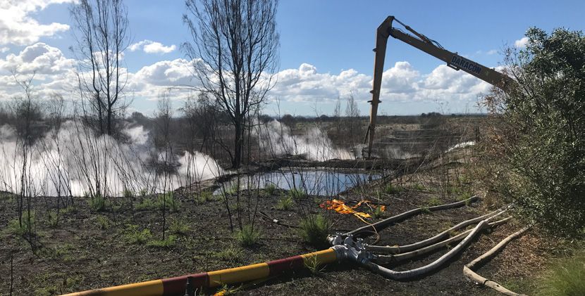
24                                26                               28
Tower apartment block failure     Bushfires                        Bushfires; night-time aerial fire
NEW SOUTH WALES, DECEMBER         TASMANIA, DECEMBER 2018 -        bombing
2018                              MARCH 2019                       VICTORIA, JANUARY 2019

30                                32                               34
Underground toxic waste fire      Storms and floods                Bushfires
NEW SOUTH WALES, JANUARY 2019     QUEENSLAND, JANUARY –            WESTERN AUSTRALIA, JANUARY –
                                  FEBRUARY 2019                    MARCH 2019

36                                38                               40
Bushfire                          Bruxner Highway fire             Bushfire
NEW SOUTH WALES, FEBRUARY 2019    NEW SOUTH WALES, FEBRUARY 2019   WESTERN AUSTRALIA,
                                                                   FEBRUARY 2019

42                                44                               46
Bushfires                         Severe tropical cyclone Trevor   Severe tropical cyclone Veronica
VICTORIA, FEBRUARY – MARCH 2019   QUEENSLAND AND NORTHERN          WESTERN AUSTRALIA, MARCH 2019
                                  TERRITORY, MARCH 2019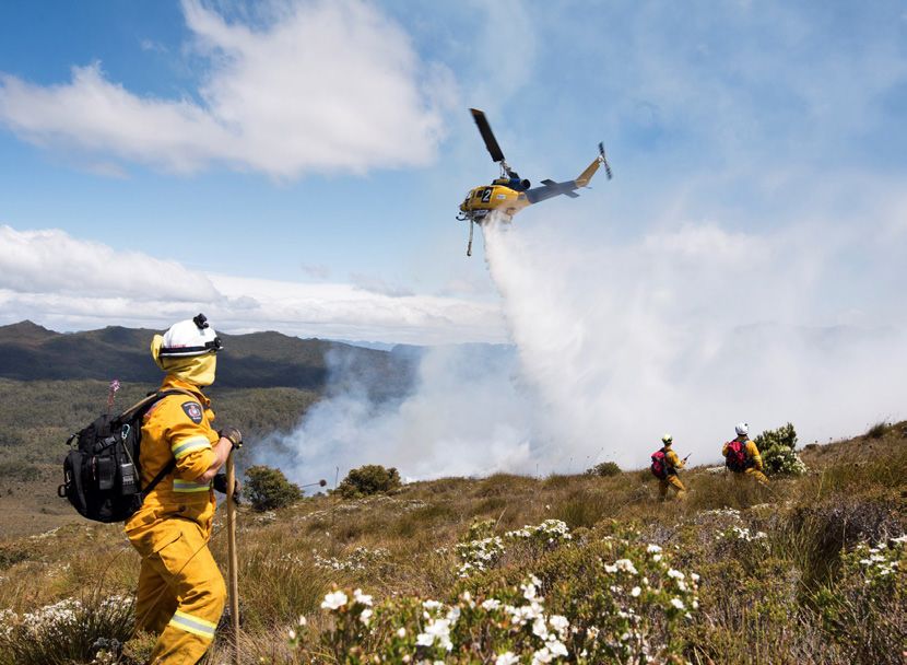
A national perspective
                                                                    ▪▪   the hottest January on record (3.37°C higher than average)
From a national perspective, the 2018-19
                                                                    ▪▪   unprecedented scale and duration of heatwaves
severe weather season was significant. In                           ▪▪   two Category 4 tropical cyclones concurrently making
addition to the front-line emergency and                                 landfall
disaster recovery services provided by state                        ▪▪   4,059,380 telephone warnings (via Emergency Alert) sent
                                                                         across Australia between 1 July 2018 to 1 July 2019
and territory agencies, consecutive natural
                                                                          -- 3,164,223 sent in Queensland alone, and
hazard impacts and their compounding
                                                                    ▪▪   significant negative economic implications.
effects drew on a very broad range of
services and capabilities from Australian                           Australian Government activity
Government agencies.
                                                                    During the course of 2018-19, the Australian Government
Several deployments to international incidents exacerbated          Crisis Coordination Centre (CCC) notified stakeholders of, and
the draw on domestic capability and capacity. Emergency             coordinated whole-of-Commonwealth responses to, a number
management systems across the country were stretched but,           of significant incidents, including:
on balance, held up.                                                ▪▪   the Indonesian tsunami
The 2018-19 severe weather season saw:                              ▪▪   the Bourke Street terrorism incident
▪▪   Australia’s hottest summer on record                           ▪▪   bushfires and heatwave in Queensland
▪▪   Queensland rainforest burning with intensity similar to fire   ▪▪   bushfires in Tasmania
     in eucalypt forest                                             ▪▪   floods in Queensland
▪▪   monsoonal floods impacting more than 50% of                    ▪▪   bushfires in Victoria
     Queensland’s land mass                                         ▪▪   the terrorist attack in Christchurch, New Zealand
      -- 39 local government areas impacted                         ▪▪   the maritime incident in the Solomon Islands
     -- over 100,000 people identified as experiencing              ▪▪   tropical cyclone Trevor
        hardship, many displaced and requiring emergency            ▪▪   tropical cyclone Veronica
        accommodation                                               The Australian Government Crisis Committee met on nine
     -- 500,000 head of cattle destroyed                            occasions with the National Crisis Committee convened once.
     -- Townsville impacted by 2000mm rainfall and Richmond         In the period January to June 2019, the Australian Government
        498 mm in 1 week                                            Disaster Response Plan (COMDISPLAN) was activated on six
                                                                    occasions and the Australian Government Overseas Assistance
▪▪   the driest September on record                                 Plan (AUSASSISTPLAN) was activated on three occasions.
▪▪   the highest daily maximum temperature on record
▪▪   the hottest December day on record (followed by 5
     consecutive days with national average over 40°C)

6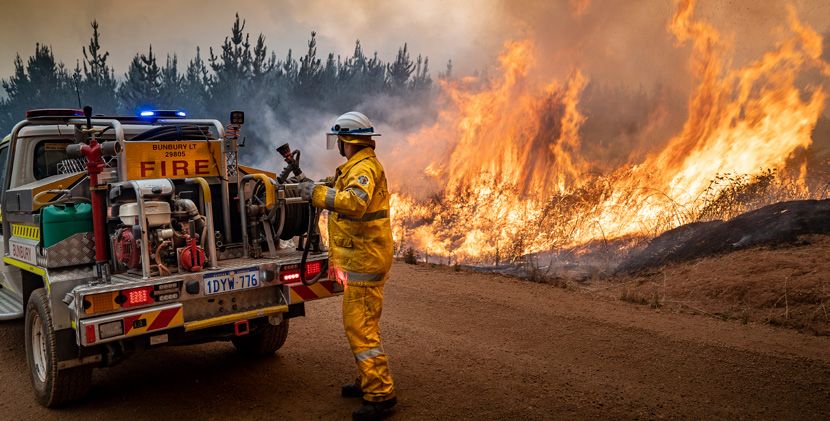
The CCC distributed over 2,000 notifications to key stakeholders    The Prime Minister approved 12 requests under the DRFA
in Australian and jurisdictional agencies. The CCC’s Crisis         for extraordinary disaster recovery assistance (compared
Coordination Team was activated for 57 days across concurrent       to 5 requests in the previous financial year), including a
incidents, deploying liaison officers for 70 days in support for    $242 million long-term recovery package to support
operations domestically and overseas. The Department of Home        communities devastated by the Queensland floods. Disaster
Affairs’ Crisis Communications Media team supported CCC             Recovery Branch within Emergency Management Australia
operations through the development and distribution of 75 sets      (EMA) worked closely with relevant Australian Government
of Talking Points and 80 media releases.                            departments and agencies to ensure that this additional
The National Security Hotline (NSH) received over 10,000            recovery funding complemented existing programs and national
contacts, assisting state and territory law enforcement and         priorities.
intelligence agencies. In March 2019, following the Christchurch    In addition to the recovery assistance under the DRFA, in
Terrorist Incident, the NSH experienced a 165% spike in contacts    2018-19 the Australian Government provided over $120 million
compared to the previous month.                                     directly to individuals and families through the Australian
The Australian Defence Force significantly contributed to all       Government Disaster Recovery Payment and Disaster Recovery
states and territories providing direct and indirect support such   Allowances following major events in Queensland, New
as heavy air lift, air base access to support aerial firefighting   South Wales and Tasmania. This was in contrast to 2017-18,
operations, tents for evacuees, defence bases for emergency         during which neither of these payments was activated. The
services staging and accommodation, support to fuel and fodder      extraordinary requests were expedited by the Commonwealth,
supply chains, and planning for carcass removal.                    ensuring disaster recovery assistance was available to affected
                                                                    communities rapidly. This was achieved by early engagement
In 2018-19, jointly funded Commonwealth-State assistance            and close collaboration between the requesting jurisdiction
under the Disaster Recovery Funding Arrangements (DRFA)             and EMA.
was activated in response to 48 domestic disaster events (24
in New South Wales, seven in Victoria, 11 in Queensland,            During 2018-19, the Australian Government also made advance
four in Western Australia, one in Tasmania and one in the           recovery payments under the DRFA totalling $232 million to
Northern Territory). Disaster recovery funding assistance was       ensure that that recovery assistance could flow to communities
activated in over 240 local government areas and over 100           devastated by the Queensland floods.
DRFA notifications were issued from states and territories to
the Australian Government as further support for recovery was
provided to affected communities.

                                                                                                                                  7
National overview
                                                                                        For more information on disasters in Australia, please go to
 This map is a depiction of the 19 incidents
                                                                                        the disasters page on the Knowledge Hub:
 described in this report which occurred in                                             www.knowledge.aidr.org.au/disasters
 Australia during 2018-19.

                                                                                                                            Mar 2019 18
                                                                                5   Dec 2018
                                                                                                                                          Dec 2018 5

                                                                                                                                        Jan-Feb 2019 12

                              Mar 2019 19
                                                                                                              4       Nov-Dec 2018             Nov-Dec 2018 4

                                                                                                                                                       Nov-Dec 2018    4

      Fire
      Tropical cyclone
      Storms and floods
      Thunderstorms
                                                                                                                                                         Feb 2019 15
      Infrastructure                                                                                                            14 Feb 2019

                                                                                                                  6          Dec 2018
                                                                                                                                                       Jan 2019 11
                                           Jan-Mar 2019 13
16 Feb 2019
                                                                                                                                                   Dec 2018    8

                                                                                        7                               3    Nov 2018
                                                                                                  Dec 2018
                                                                                                                                                Aug 2018 1

                                                                                    2       Aug 2018 & Apr 2019                         Jan 2019 10
                                                                                                                                   Feb-Mar 2019 17

      1   Bushfire, NSW                                   11   Underground toxic waste fire, NSW
      2   Warehouse fires, VIC                            12   Storms and floods, QLD
      3   Bushfire, ACT                                   13   Bushfires, WA
                                                          14   Bushfire, NSW                                                        Dec 2018 - Mar 2019 9
      4   Bushfires, QLD
      5   Tropical cyclones, QLD                          15   Bruxner Highway fire, NSW
      6   Severe thunderstorms, NSW                       16   Bushfire, WA
      7   Storms and floods, VIC                          17   Bushfires, VIC
      8   Tower apartment block failure, NSW              18   Severe tropical cyclone Trevor, QLD & NT
      9   Bushfires, TAS                                  19   Severe tropical cyclone Veronica, WA
      10 Bushfires; night-time aerial fire bombing, VIC

8
Lessons
management
This report harnesses the lessons The OILL process (observation, insight, lessons
management capability of the emergency identified, lessons learned)
services sector to provide observations The OILL process is one approach to synthesising observations,
analysing for insights and identifying lessons. This approach is
related to each incident or related hazard widely used by many emergency management agencies as well
response. There are limitations in these as military and private sector organisations. A description of
observations given the time of publication of each step in the OILL process is provided below:
this report so soon after the events in some Observation: a record of a noteworthy fact or occurrence
that someone has heard, seen, noticed or experienced as an
instances. opportunity for improvement or an example of good practice.
Insight: A deduction drawn from the evidence collected
What is lessons management? (observations), which needs to be further considered. An insight
defines the issue, not the solution.
Lessons management is a cycle of collecting, analysing,
disseminating and applying learning experiences from events, Lesson identified: a conclusion with a determined root cause
exercises, programs and reviews. The goal of this activity based on the analysis of one or more insights and a viable
is ongoing improvement by organisations and the people course of action that can either sustain a positive action or
who work for them. Organisational growth and continuous address an area for improvement.
improvement are particularly relevant where preservation of life Lesson learned: A lesson is only learned once the approved
is the primary goal. change is implemented and embedded in the organisation.
Depending on the changes required, it may take several years
Why is lessons management important? for the change to be institutionalised across the organisation.
A consistent approach to lessons management is an essential
component of an organisation that has a culture of learning.
Lessons management can facilitate learning and improvement For more detailed information and guidance on lessons
resulting in more efficient and effective practices, improved management, refer to the Lessons Management
safety, and improved capture and mobilisation of knowledge. Handbook on the Australian Disaster Resilience
Organisations are seen to be learning when their structures, Knowledge Hub: www.knowledge.aidr.org.au/
processes and culture are able to evolve based on learning resources/lessons-management-handbook/
acquired from experience.
Interoperability of lessons management processes across
agencies, sectors and jurisdictions will facilitate information
sharing and analysis. A common language and methods (such
as agreed coding of data) can help aggregate information so
that it is accessible and can be analysed and interpreted. This
will support the horizontal and vertical exchange of information
between agencies, sectors, and jurisdictions – all of which will
improve and promote cross-agency analysis.
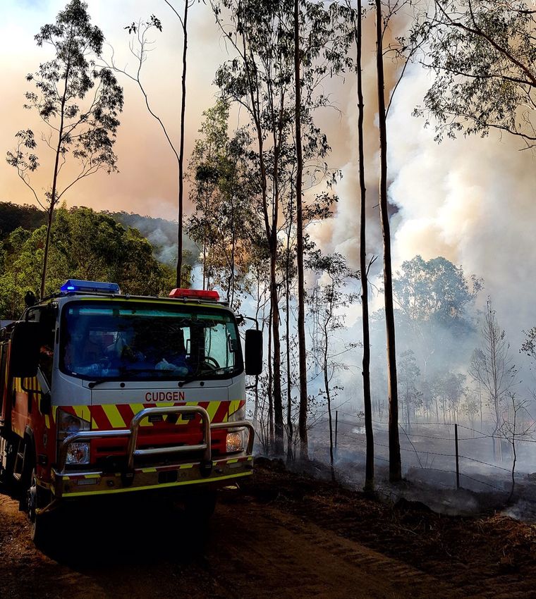
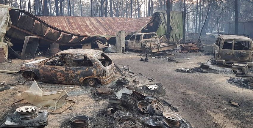
9Bushfire
New South Wales, August 2018
By 17 August, the fire had grown to 1,700 hectares and a
In August 2018, below average rainfall was
number of water bombing helicopters were operating on the
recorded throughout much of New South fire. At about 2.00pm one of the helicopters, which had been
Wales (NSW) including the NSW south coast, operating since early morning with a Bambi bucket suspended
beneath it, crashed after the bucket became entangled in trees.
and mean maximum temperatures were
Despite on-scene firefighters providing immediate aid, the
generally above average. experienced pilot and sole occupant of the aircraft was unable
August rainfall totals for NSW as a whole were 57 per cent to be revived.
below normal, the lowest since 2013. This continued a run of Other pilots in the vicinity at the time reported south-easterly
eight consecutive months of below-average rainfall for the state, winds between 10 and 20 knots, with visibility limited to three
resulting in the driest January to August period since 1965. All of kilometres due to the smoke.
NSW was either in drought or drought-affected.
The helicopter was a 1994 Kawasaki BK117 that had been
There were a number of bushfires burning across the state registered to Sydney Helicopters since May 2015. It was
during the second week of August, and some 870 firefighters destroyed in the crash. Immediately after the crash, NSW RFS
and 270 fire trucks supported by 33 water bombing aircraft grounded all other aircraft fighting the fire.
were tackling the blazes. On 15 August, the NSW Rural Fire
Australian Transport Safety Bureau staff and NSW Police
Service (RFS) Commissioner declared a bushfire emergency,
attended the scene and commenced a formal investigation.
and a total fire ban was declared for the Sydney, Illawarra and
As at 30 June, the final report into the incident was yet to be
Hunter Valley regions. This was the earliest total fire ban on
handed down.
record for NSW.
The Kingiman bushfire started near Croobyar Road on Saturday
11 August some 10 kilometres west of Ulladulla on the NSW Acknowledgements: NSW Rural Fire Service; Australian
south coast. Crews from NSW RFS and the National Parks and Transport Safety Bureau; ABC News; Sydney Morning
Wildlife Service, supported by water bombing aircraft, fought Herald; The Guardian.
the fire over the following days, containing it to 100 hectares.
However, early on 15 August the fire flared out of control and
under the influence of strong north-westerly winds, spread
rapidly to the south-east, crossed Woodstock Road and
impacted properties west of Burrill Lake. An emergency warning
was issued to residents around Woodstock as firefighters fought
to bring the fire under control.
A local emergency operations centre was established in Nowra
by the local emergency operations controller to support
firefighting efforts and coordinate support to affected
communities, and an evacuation centre was opened at the
Ulladulla Civic Centre.
10Observations
▪▪ The impact of climate change on weather-
related emergencies and disasters occurring
outside of traditional cyclone, storm, flood and
bushfire seasons necessitates year-round:
-- agency readiness to respond and issue
information and warnings
-- community awareness of potential threats,
warnings and limitations (e.g. total fire
bans).
Images: NSW Rural Fire Service 11Warehouse fires
Victoria, August 2018 and April 2019
Both fires presented similar challenges for firefighters:
On Thursday 30 August 2018, a fire broke
▪▪ the lack of adequate fire suppression systems in the
out in a large warehouse in West Footscray,
buildings enabled the fires to grow rapidly before
an inner-western suburb of Melbourne. firefighters arrived
▪▪ the large volumes of combustible products stored made
The fire emitted a large plume of toxic black smoke, visible
the fires difficult for firefighters to extinguish
across Melbourne and from as far away as Geelong and took the
Metropolitan Fire Brigade (MFB) 14 hours to bring under control ▪▪ the fires’ proximity to residential areas and sensitive
and several days to extinguish. ecosystems made the containment of contaminated runoff
a priority.
The MFB was alerted to the fire in Somerville Road at around
Despite these challenges, both fires were controlled relatively
5.00am and arrived within six minutes. By then, the 100 x 200
quickly in accordance with established emergency management
metre warehouse was fully alight. Initially, 80 firefighters and 20
priorities. There were no deaths (but serious burn injuries
fire appliances attended, with the number of firefighters later
to a worker at the Campbellfield warehouse), no loss of
rising to more than 140. Firefighters’ ability to reach the seat of
infrastructure and other assets adjacent to the warehouses, and
the fire was hampered by walls of shipping containers and 200
limited disruption to communities and businesses outside the
litre drums stacked inside the building.
immediate environs of the fires.
Soon after the fire began, authorities issued a ‘watch and act’
After the West Footscray fire, WorkSafe Victoria and the Local
community advice message for ten nearby suburbs; anyone
Government Authority confirmed that the warehouse was
within 500 metres of the plume was advised to remain indoors.
not registered to store dangerous chemicals. This prompted
During the afternoon, the community advice was extended to
the establishment of a state government taskforce, led by
include 20 suburbs.
Worksafe Victoria, which commenced the inspection of other
Despite the efforts of firefighters and support agencies to industrial properties across Victoria to assess compliance with
contain contaminated runoff, dead fish, eels, birds and other the Dangerous Goods Act. The taskforce found that many others
wildlife washed up on the banks of nearby Stony Creek within 24 didn’t comply, including the Campbellfield warehouse, which
hours of the fire starting. The Environment Protection Authority was last inspected on the day before it caught fire.
(EPA) warned people not to eat fish from the creek or the lower
While it was a registered dangerous goods site, the
Yarra River and not to enter or allow dogs to enter the creek.
Campbellfield warehouse’s licence had been suspended by the
To reduce the risk of exposure to children, some school EPA on 15 March and a clean-up notice issued after it found
principals and early learning centre operators in the 450,000 litres of chemicals, 300,000 litres above its licensed
neighbouring suburbs of Yarraville, Kingsville, Braybrook, Altona, limit, stored there. The day before the fire, the EPA discovered
Brooklyn and Seaholme closed their facilities temporarily. that 300,000 litres, double its limit, were still there.
At the request of the MFB, a coronial investigation into the fire At the MFB’s request, a coronial investigation into this fire was
was opened and Victoria Police arson squad detectives began also commenced. The Victorian Premier announced that the
preparing a brief for the State Coroner. government was prepared to make regulatory changes if an
On Friday 5 April 2019, the MFB was called to a similar investigation into the fire revealed shortcomings.
fire in another warehouse, this time in Thornycroft Street,
Campbellfield.
Acknowledgements: Metropolitan Fire and Emergency
Approximately 175 firefighters attended, preventing the fire Services Board; ABC News; The Age.
spreading beyond the warehouse and bringing it under control
within hours. But like the West Footscray fire, it took several
days to completely extinguish.
12Observations
▪▪ Appropriate training and skills maintenance at all levels ▪▪ Appropriate processes and responsibilities established
will facilitate critical event logging and recording of other at multiple levels will help ensure information critical
key incident information. to incident management is available to the incident
▪▪ The rigorous application of agreed protocols for issuing controller.
community information and warnings will ensure the ▪▪ Processes to manage emergency incidents that are
delivery, by the designated incident control agency, of scalable upwards and downwards, tested to ensure they
accurate, comprehensive, relevant, timely and consistent are adaptable to changing incident size and complexity,
messages. will enhance emergency management outcomes.
Images: Assistant Chief Fire Officer Robert Purcell, Metropolitan Fire Brigade 13Bushfire
Australian Capital Territory, November 2018
members of the public with advice on current fire conditions
New South Wales (NSW) and Australian
and how to prepare.
Capital Territory (ACT) experienced a
Without being prompted by the authorities, horse owners
heatwave over the last few days of October activated their fire plans and moved horses to various safe
2018 that continued into early November. locations around the Canberra region.
During the early evening of Thursday 1 A thunderstorm that afternoon dropped light rain over the fire
ground, causing the humidity to rise and the temperature to
November, a burnt-out car sparked a fire at fall. These milder conditions enabled firefighters to slow the
Pierces Creek a few kilometres to the west fire’s spread and strengthen containment lines. However, the
of Canberra’s urban fringe. thunderstorm caused significant damage elsewhere, with 150
calls for assistance to the SES, mainly to deal with fallen trees in
A total fire ban was declared for the following day. Twenty-three the ACT’s Tuggeranong area.
firefighting appliances from the ACT Rural Fire Service (RFS), Two additional helicopters joined firefighting efforts on Saturday
supported by six helicopters, three bulldozers, two graders and morning, with crews working in very rugged and steep terrain.
an excavator battled the fire that day in warm, dry and windy The fire, now causing no immediate threat to life or property,
conditions. grew to 200 hectares by Saturday afternoon and burned to
Due to its rapid and erratic spread, the fire initially posed a risk within seven kilometres of the nearest Canberra suburb of
to rural settlements in the south of the ACT. About 150 students Kambah.
from Miles Franklin Primary School, who had been at the Birrigai Easing conditions that day helped firefighters extinguish
Outdoor School at Tidbinbilla, were evacuated safely on Friday spot fires while bulldozers removed hazardous trees and
morning. Galilee School in Kambah was also evacuated that strengthened containment lines. Favourable conditions
morning. All other ACT schools remained open. continued overnight, with RFS crews mopping up most
Tidbinbilla Nature Reserve was closed to the public and staffing remaining hot spots and delivering an improved outlook for
at the NASA tracking station was reduced to key personal. The Sunday.
tracking station disabled their tracking dishes, allowing the The fire remained at ‘advice’ level on Sunday, burning in country
aircraft exclusion zone to be temporary lifted and providing largely sheltered from the wind and not experiencing the same
firefighting aircraft greater access to the fire. Two water drops hot and windy conditions as nearby Canberra. Several roads
by a large airtanker were used to protect a communication remained closed on Monday.
tower and slow the fire’s spread.
For many Canberra residents, the fire triggered memories of the
Several roads were closed, including parts of Paddy’s River Road, 2003 ACT bushfires that killed four people and destroyed nearly
Tidbinbilla Road and Kambah Pool Road. Kambah Pool, Camp 500 homes.
Cottermouth, Bullen Range Nature Reserve and Pierces Creek
Forest were also closed.
On the Friday afternoon, ACT Emergency Services Agency (ESA)
personnel from ACT RFS, ACT State Emergency Service (SES), Acknowledgements: ACT Emergency Services Agency;
and ACT Fire and Rescue (F&R), including ACT F&R community Bureau of Meteorology; ABC News; Canberra Times.
fire unit members, door-knocked 1,440 homes in suburbs
from Kambah to Gordon. Residents were reminded what the
alert levels meant, what they should do to prepare for the
approaching fire season, and to be prepared to enact their
bushfire survival plans. ESA personnel also set up information
booths at a major shopping centre nearby and provided
14Observations
▪▪ Well implemented community education programs work, ▪▪ A record number of hits on emergency services’ websites
evidenced by the preparation of plans, and homes, for the and social media platforms reinforces the value of these
bushfire threat. mediums for the provision of current and accurate
▪▪ Door-knocking and the provision of information at pop-up information.
information booths helps increase community awareness ▪▪ Incident management teams that include expertise across
of emergency events and improves community response. multiple hazards enable the increasing occurrence of
multi-hazard events to be managed by a single team.
Images: ACT Rural Fire Service 15Bushfires
Queensland, November and December 2018
5 December. Queensland State Emergency Service personnel
Extreme heat affected much of the east
and Australian Defence Force personnel also provided support.
coast of Queensland in the last week of Due to the extreme weather conditions, several firefighters
November 2018, with record-breaking suffered severe heat stress.
temperatures at many locations. Fifty-nine aircraft were sourced through the National Aerial
Firefighting Centre and elsewhere, dropping 12 million litres
The extended heatwave resulted in some locations reporting of water and fire retardant on the fires. On the busiest day,
their highest November mean daily maximum temperature on 47 aircraft were deployed. The Royal Australian Air Force Base
record, and a number of sites, including Cairns, Mackay and Amberley was used by many of the aircraft over six days.
Proserpine, had their highest November mean temperature on
From 22 November to 6 December, 1.4 million hectares of land
record.
burned across Queensland and a young man was killed on 30
As the high temperatures, dry conditions and strong westerly November by a falling tree while protecting his family property
winds elevated the fire danger, catastrophic fire danger ratings in the Rolleston area. In total, 9 homes were destroyed, 17
occurred in Queensland for the first time. More than 2,300 homes were damaged alongside numerous sheds and vehicles,
fires were attended to across the state, with more than 180 and significant damage occurred to crops and pastures.
fires burning concurrently at the height of the emergency.
Many schools were closed for several days, and the impact
Most occurred in central eastern Queensland, with the most
of the fires on communities, agriculture, tourism and the
significant fires around Gladstone, Rockhampton and Mackay.
environment was significant.
Thirty-five communities in eight local government areas were
Joint Commonwealth–State disaster recovery funding was made
severely impacted by the fires. Over 50 emergency alerts
available for impacted communities in six local government
were issued over multiple days for several locations in eastern
areas including Bundaberg, Gladstone, Isaac, Livingstone,
Queensland on 28 November. More than 700,000 emergency
Mackay and Rockhampton.
alert text messages were sent to residents in an area stretching
700 kilometres north from Hervey Bay to Bowen and more than On 6 December, the Queensland Minister for Fire and
300 kilometres west to Carnarvon and Clermont. More than Emergency Services commissioned a report on the effectiveness
570 bushfire emergency warnings were issued between 24 of the disaster management preparations for, and response
November and 7 December. to, the heatwave and subsequent bushfires. Queensland’s
Inspector-General Emergency Management delivered his report,
On 29 and 30 November, a slow moving fire travelled from
the 2018 Queensland Bushfires Review, to the Minister on 31
Eungella National Park in a south-westerly direction towards
May 2019.
Broken River west of Mackay and evacuation warnings were
issued to communities including Finch Hatton, Eungella, On 3 April, the Central Queensland Bushfires Recovery Plan was
Dalrymple Heights and Carmila. Numerous evacuation centres released jointly by the Queensland Premier and the Minister for
were set up to provide shelter for people fleeing bushfire- State Development, Manufacturing, Infrastructure and Planning.
affected areas. Around 8,000 people were forced to evacuate
their homes at Gracemere, near Rockhampton, due to nearby
fires. Acknowledgements: Queensland Fire and Emergency
Services; Queensland Inspector-General Emergency
Over 3,500 firefighters from Queensland Fire and Emergency Management; Bureau of Meteorology; Brisbane Times.
Services and Queensland Parks and Wildlife Service fought the
fires together with 1,200 firefighters from all other Australian
states and territories. The first of the interstate firefighters
arrived on 26 November and the last departed ten days later on
16Images: Queensland Fire and Emergency Services 17
Tropical cyclones
 Queensland, December 2018

                                                                     Floodwaters closed a number of roads north of Ingham and
 A tropical low developed into tropical
                                                                     motorists were advised to avoid using the Bruce Highway
 cyclone Owen over the Coral Sea on Sunday                           between Cairns and Townsville. More than 900 homes just
 2 December 2018 but was downgraded to                               south of Townsville were without power for several hours that
                                                                     day. Surf lifesavers performed multiple rescues of swimmers
 a tropical low while still well off the north                       in rough seas as far south as the Sunshine Coast, including five
 Queensland coast two days later.                                    children who were rescued by jet ski.

 Tropical cyclone Owen then moved west towards northern              Owen produced steady heavy rainfall on its second pass,
 Queensland and crossed the coast near Port Douglas at around        resulting in well above average rainfall for eastern Queensland
 3.00am on 10 December, bringing rainfall between 250–350            for December, and localised flash flooding. There were daily
 millimetres to the northern tropical coast.                         totals over 300 millimetres near Ingham, including 678
                                                                     millimetres at Halifax, a new December daily rainfall record for
 Owen continued westward across Cape York Peninsula and              Australia.
 redeveloped into a tropical cyclone in the Gulf of Carpentaria on
 11 December, reaching category 2 strength the following day.        Cyclone- and flood-affected communities in six local
                                                                     government areas including Carpentaria, Cassowary Coast,
 Owen continued to intensify into a severe tropical cyclone          Douglas, Hinchinbrook, Townsville and Wujal became eligible for
 (category 3) near the Gulf’s south-west coast before turning east   joint Commonwealth–State disaster recovery funding.
 and again heading for Cape York Peninsula. An emergency alert
 was issued on 13 December for the western Cape community            In late December, another tropical low developed in the Coral
 of Pormpuraaw; four more emergency alerts were issued for           Sea and headed west over the Cape York Peninsula south of
 Pormpuraaw and Kowanyama communities the following day.             Lockhart River on Sunday 30 December. The low tracked back
                                                                     east and reached tropical cyclone (category 1) strength over
 Queensland Fire and Emergency Services (QFES) deployed 60           the north-west Gulf of Carpentaria on the morning of 1 January
 extra staff, including emergency management coordinators,           2019. Named tropical cyclone Penny, the system again made
 swift water rescue and air operations specialists, State            landfall on the Cape south of Weipa that afternoon, uprooting
 Emergency Service (SES) crews and two drones to areas               trees and flooding roads before weakening to a tropical low.
 likely to be impacted. Police and SES crews door-knocked in
 remote Cape communities to ensure all were aware of Owen’s          For the period 29 December 2018 to 6 January 2019 the SES
 approach. While communities were reportedly well prepared,          received more than 50 requests for assistance from the public.
 the SES received 233 requests for assistance on the night of        As the system re-entered the Coral Sea, it re-intensified into
 14 December (its busiest), and more than 690 requests for           a category 2 system then turned west, back towards north
 assistance for the period of 10 to 20 December.                     Queensland, weakening again as it approached the coast.
 Owen made landfall near the small Aboriginal community of           Penny remained active over the Coral Sea and Queensland’s
 Kowanyama (1,400 residents) on the western side of the Cape         tropical east coast until 9 January. BOM issued severe weather
 early on 15 December with wind gusts of up to 170 kilometres        warnings and flood warnings as Penny approached the coast
 per hour. Damage in the town was minimal after the cyclone          on 9 January, producing moderate to locally heavy falls along
 track turned south and missed the settlement.                       Queensland’s central and Capricornia coasts on 9 and 10
 Owen again weakened to a tropical low as it tracked across the      January.
 northern tropics, reaching the Cape’s east coast the following      The Burdekin area received significant rainfall overnight on 9
 day. As Owen headed down Queensland’s east coast, the Bureau        January, with 108 millimetres falling at Groper Creek between
 of Meteorology (BOM) issued a severe weather warning and            midnight and 3.00am, and Strathbogie, south of Ayr, recorded
 multiple flood warnings and flood watches for several river         360 millimetres in 24 hours.
 catchments across northern and central Queensland.

18
Observations
▪▪ When managing the evacuation of communities under ▪▪ Good disaster management includes supporting and
threat, planners should be realistic when estimating the enabling government and non-government organisations
time needed to complete the withdrawal phase. that deliver a broad range of support services that
▪▪ Reflecting on the management of emergencies and augment disaster management and improve community
disasters enhances the management of future events. In recovery.
particular, improving communications within and between ▪▪ Early engagement with those focused on community
emergency management agencies, and with communities, recovery improves emergency and disaster management
will deliver better emergency management outcomes. outcomes.
Penny brought much needed rain to the Townsville area. A few
kilometres north of the city, Pallarenda recorded 45 millimetres Acknowledgements: Queensland Fire and Emergency
in the 24 hours to 10 January while North Ward, Alligator Services; Bureau of Meteorology; ABC News; Courier
Creek and South Townsville recorded 43, 26 and 31 millimetres Mail; Townsville Bulletin.
respectively over the same period.
Not all of the rain was welcome, and flood-affected
communities in ten local government areas including Cook,
Douglas, Hope Vale, Mapoon, Northern Peninsula, Pormpuraaw,
Torres, Torres Strait Island, Whitsunday and Wujal became
eligible for joint Commonwealth–State disaster recovery funding
as a result of Penny and the tropical low that followed.
Image: Queensland Fire and Emergency Services 19Severe
thunderstorms
New South Wales, December 2018
Rural Fire Service, Fire and Rescue NSW, NSW Volunteer Rescue
On Thursday 13 December 2018, a slow
Association, Ambulance NSW, NSW Police Force and the ACT
moving low pressure system developed SES.
over south-east Australia, causing severe The worst impacted community was Berowra, 27 kilometres
thunderstorms across eastern New South north of the Sydney CBD, although most metropolitan local
government areas were impacted to some degree.
Wales (NSW) lasting several days.
NSW SES established a pop-up public information point
As a result of these storms, the NSW State Emergency Service in Berowra on the morning of 21 December. Tarpaulins
(SES) received over 5,300 requests for assistance from impacted and sandbags were made available to residents, as well as
communities and natural disaster declarations were made in 14 information about the response and recovery process, services
NSW local government areas. The most significant damage was available and how to carry out repairs.
reported across the Greater Sydney region.
A larger disaster assistance point was set up later that day,
During the afternoon and evening of Thursday 20 December, providing a central location for advice and assistance from
another slow moving low pressure system produced more welfare providers, insurance companies, the local council
severe thunderstorms across central, eastern and northern and NSW SES. The SES also coordinated approximately 200
NSW. Areas impacted stretched from Grafton, Tamworth and spontaneous volunteers seeking to support response and
Moree in the north, to Nowra and Batemans Bay in the south recovery efforts in the Berowra area.
and Dubbo in the west.
As at 17 July 2019, the insured loss caused by the NSW
These severe thunderstorms produced more than 30,000 December thunderstorms was an estimated $1.313 billion, with
lightning strikes, large hailstones, destructive winds and intense 125,600 domestic insurance claims and 12,195 commercial
rainfall and flash flooding across Sydney, the Blue Mountains claims. While one of the costliest events in Australia in 2018,
and Central Coast regions. Hailstones up to eight centimetres impacts were significantly less than the April 1999 hailstorm
in diameter were reported in the Greater Sydney region, that impacted Sydney. In today’s dollars, insurance claims for
which suffered extensive property damage. Many of the areas that event approached $5.6 billion.
impacted had suffered damage during the previous week’s
The majority of insurance claims for the 2018 event were for
storms.
motor vehicle damage but significant damage also occurred to
At Sydney Airport’s domestic terminal, flights were delayed for buildings. Car windshields and roofs were damaged by hail, and
up to 90 minutes and three-hour delays were experienced at cars, homes and commercial properties were impacted by rain
the international terminal. Sixty-two flights were cancelled and and flash flooding.
seven were diverted.
On 20 December, the Insurance Council of Australia declared
Multiple rail lines in Sydney’s inner west, airport precinct and the thunderstorms a catastrophe, enabling insurance claims to
outer suburbs as well as intercity links experienced stoppages be prioritised.
or delays after lightning struck power supplies and other
Following the storms, joint Commonwealth–State disaster
infrastructure. Endeavour Energy and Ausgrid reported tens of
recovery assistance was made available to affected communities
thousands of customers across their electricity networks were
in up to 32 NSW local government areas.
without power due to lightning strikes and toppled power lines.
NSW SES received an additional 6,314 requests for assistance
and 9,837 calls to the state operations centre as a result of the Acknowledgements: NSW State Emergency Service;
20 December thunderstorms, and deployed more than 500 Bureau of Meteorology; Insurance Council of Australia;
SES volunteers. Additional support was provided by the NSW ABC News; The Guardian.
20Observations
▪▪ The establishment and maintenance of strong strategic ▪▪ Spontaneous volunteers provide a valuable resource
and operational relationships between emergency to communities and response and recovery agencies
response agencies prior to disasters enables early, during and after incidents. Coordinating the efforts of
coordinated and effective disaster response. spontaneous volunteers can, however, be time and
▪▪ Improved connections and interactions between resource intensive. The development and delivery of
emergency response agencies and recovery agencies frameworks and training packages that focus on managing
facilitates the provision of timely information and these volunteers during emergencies and disasters will
assistance to affected communities during emergencies deliver improved community recovery outcomes.
and disasters, and enhances community recovery.
Image: Raj Eiamworakul on Unsplash 21Storms and floods
Victoria, December 2018
Severe thunderstorm warnings remained in place that night for
A low pressure system developed over
Melbourne as well as central and western Victoria, including
central Victoria early on Thursday 13 Ballarat, Daylesford and Hamilton.
December 2018, prompting a severe The SES received 1,736 requests for assistance, and 73
weather warning for heavy rain to be issued rescues were performed over 13–16 December, working
with emergency management partners to support impacted
for most of the state. communities. The SES received more than 400 calls for help
The low drifted north-west into New South Wales by late the in the Melbourne metropolitan area on the evening of 14
following day, then turned to move slowly southwards close to December.
the South Australia–Victoria border on 15 December, gradually Many sites in Victoria had their highest December daily
weakening during the day. rainfall on record over 13–14 December, or their highest
The low pressure system generated severe thunderstorms in total December rainfall on record. Eldorado, 15 km east of
Victoria’s north-west, with a month’s worth of rain falling over Wangaratta, was the wettest place in Victoria in December,
parts of northern Victoria during the 48 hours to 9.00am on 14 recording 215.4 millimetres during the month, more than four-
December. The small Mallee township of Birchip recorded 130 times its December average.
millimetres of rain during the 24 hours to 9.00am that day, with The rain and associated flooding caused significant damage to
flash flooding affecting around 20 homes. residential and commercial properties and public infrastructure
Flood warnings were issued 300 km to the east for Wangaratta, across Victoria. Joint Commonwealth–State disaster recovery
Byawatha, Peechelba, Markwood, Everton, Carboor, Moyhu and assistance was subsequently made available to facilitate
surrounding areas, including the Hume Highway. Flash flooding community recovery and ensure damaged public infrastructure
of the Hume Highway near Wangaratta caused approximately 50 was restored as soon as possible in nine local government areas
vehicles to become trapped in floodwaters, with many drivers across northern Victoria.
and passengers being winched to safety by emergency service
helicopters. The highway and many other local roads in the
Acknowledgements: Victoria State Emergency
north-east remained closed by floodwaters for several hours.
Service; Emergency Management Victoria; Bureau of
Relief centres for those evacuating flood-affected properties in Meteorology; ABC News; The Age; The Guardian.
the area were opened in Wangaratta, Chiltern and Wodonga.
Later that day, 41.2 millimetres of rain fell in Melbourne, most
of it in a 20-minute period after 5.00pm. The State Emergency
Service (SES) was called to rescue 25 people whose vehicles
became trapped in flood waters during the city’s peak hour.
Train lines in the eastern suburbs were seriously disrupted
by flash flooding and thousands of train commuters were left
stranded after several train services were suspended.
The most building damage occurred to homes in inner eastern
and south-eastern suburbs. More than 6,000 homes in
Melbourne’s south-western suburbs, including in Werribee,
Hoppers Crossing and Truganina, were left without power as the
storm swept through the city. Almost 3,000 homes in bayside
suburbs also experienced outages.
22Image: Fábio Hanashiro on Unsplash 23
Tower apartment
 block failure
 New South Wales, December 2018

                                                                          NSW Public Works engineers, FRNSW urban search and rescue
 Opal Tower is a $128 million dollar high-rise
                                                                          specialists and a representative of the building designers
 residential building in Sydney Olympic Park,                             inspected the tower, concluding that it was not in danger of
 New South Wales (NSW). The triangular-                                   collapse, allowing most residents to re-occupy the building
                                                                          the following day. However, residents in 51 of the units were
 shaped 117 metre tower consists of 36                                    only able to return briefly to retrieve pets, medications and
 levels above ground and three levels of                                  essential personal items. On 27 December, all residents were
 underground car parking. The building can                                evacuated again while a more thorough engineering analysis
                                                                          was conducted.
 accommodate 3,000 residents and includes
 retail shops and a childcare centre for 80                               Following more detailed inspection, the worst damage was
                                                                          found on levels 4 and 10, with levels 3, 9, 16 and 26 and
 children.                                                                basement level 3 also subject to potential structural damage.
 During its construction, the tower was considered a state                Structural failings occurred above and below the ‘garden
 significant site that did not require council approval. The              slots’; recesses in the tower’s facade where precast concrete
 tower was signed off by private certifiers and was completed             panels joined structural columns. Bracing was installed as a
 in August 2018. Occupation of the 392 residential apartments             precautionary measure to reinforce these areas while further
 commenced soon afterwards.                                               major work to fix damage on level 4 and level 10 continued.

 On Monday 24 December 2018, loud cracking noises were                    In the meantime, residents were housed in hotel
 heard by tower residents and many experienced increasing                 accommodation with the builder paying their food and
 difficulty opening doors as door frames warped. Several cracks           accommodation costs until their units were declared habitable
 were observed in concrete panels on level 10, sparking fears             by the body corporate’s engineers. Seventy-four units in the
 that the tower might collapse and prompting several residents            tower were declared habitable in late January, four weeks after
 to evacuate.                                                             cracks first appeared in the tower, but many residents refused to
                                                                          return until all rectification works were completed. The builder
 After receiving several Triple Zero calls at about 3.00pm, Fire          refused to continue paying costs for any residents not returning
 and Rescue NSW (FRNSW), NSW Police (NSWP) and Ambulance                  to habitable units. A further 97 units were deemed habitable in
 NSW attended the scene, with NSWP responsible overall for                early February.
 incident management. Evacuation of the tower was completed,
 and a 300 metre exclusion zone was established.                          The NSW Government initiated an independent investigation
                                                                          into the cause of damage to the tower, how the damage could
 As the tower had only recently been completed, it was unclear            be rectified and sought recommendations that would assist in
 initially how many people occupied it and whether all had                avoiding problems with future high-rise construction in NSW.
 evacuated. Many evacuees left behind pets, medication,                   The final report was delivered to the NSW Minister for Planning
 passports and other important documentation. In all, 1,700               and Housing on 19 February 2019.
 people from Opal Tower and other nearby buildings were
 displaced. A temporary evacuation centre was established                 Among other things, the report found that some building
 nearby at the Sydney Showground.                                         elements were under-designed and that construction and
                                                                          material deficiencies were likely to have precipitated the
 Due to its proximity to the tower, Sydney Olympic Park railway station   failure of these elements. Furthermore, the report found that
 and associated underground rail lines were temporarily closed.           the building could be repaired with significant and appropriate

24
Observations
▪▪ The early establishment of a forward command point This includes but is not limited to well publicised, relevant,
and a joint emergency operations centre facilitates frequent and regular briefings.
coordinated multi-agency incident management. ▪▪ The early identification of suitable evacuation centres in
▪▪ Critical decision making is enhanced when appropriate reasonable proximity to incidents facilitates evacuation
technical experts are readily available to the incident management.
management team. ▪▪ Emergency services should avoid getting involved in public
▪▪ Early attention to the needs of people displaced by debate on issues outside their legislated role.
incidents enables the impact on them to be minimised.
rectification works, and that these should be completed and
independently assessed before the building was re-occupied. Acknowledgements: Fire and Rescue New South Wales;
Finally, the report included recommendations to improve the The Guardian; Sydney Morning Herald; The Urban
robustness of structural designs, the implementation of those Developer; Unisearch.
designs during construction and the transparency and public
accountability of the regulatory systems relating to building.
Image: Flickr photo by Simon_sees shared under a Creative Commons (BY-ND) license 25Bushfires
Tasmania, December 2018 - March 2019
Action by tanker-based firefighters limited house losses in the
In western Tasmania, rainfall was well below
Huon Valley to five, but a wood veneer mill remained closed
average during spring 2018 and Tasmania’s for several months following damage to key buildings, power
mean temperature in December was the infrastructure and its timber supply.
warmest on record. The Great Pine Tier fire threatened shack settlements at Little
Pine Lagoon, Miena and Reynolds Neck, with firefighters limiting
On Friday 28 December 2018, several bushfires were discovered structural losses to three dwellings. Many of the estimated
following lightning in western Tasmania on 27 December, 30–40 evacuees from affected settlements gathered at an
with many being brought under control over following days. evacuation centre established in the town of Bothwell.
However, a fire near the Gell River in the Tasmanian Wilderness
Additional firefighters and support personnel from the
World Heritage Area (TWWHA) was unable to be controlled
Australian Capital Territory, New South Wales, Queensland,
and spread some 40 kilometres to the south-east over the next
South Australia, Western Australia and New Zealand (NZ),
several weeks.
including many remote area specialist firefighters, and support
January 2019 was Tasmania’s warmest and driest on record. personnel from Victoria for the base camp, joined fire crews
On 4 January, many residents evacuated from the township of from the Tasmania Fire Service, Parks & Wildlife Service and
Maydena and other settlements in the Tyenna Valley when thick Sustainable Timber Tasmania to fight the fires. In all, more than
smoke from the Gell River fire, 20 kilometres to the north-west, 700 firefighters battled the blazes at their height, including 159
blanketed the area. Many roads were closed, and 400 campers from interstate and NZ. Firefighters were supported by up to
were forced to leave the popular Mt Field National Park when 44 aircraft, many supplied through National Aerial Firefighting
it came under threat. Milder conditions over subsequent days Centre arrangements.
slowed the fire’s spread, enabling residents and tourists to
Over the following weeks, dozens of fires continued to spread,
return.
many merging with one another. Ultimately, the four largest
Lightning strikes on 15 January ignited some 60 additional fires included Riveaux Road (64,000 hectares), Great Pine
fires, mainly in Tasmania’s west and central highlands. Many Tier (51,000 hectares), Moore’s Valley (36,000 hectares) and
were controlled or self extinguished over subsequent days, Gell River (35,000 hectares). These four fires had a combined
but several burning in remote and rugged terrain continued to perimeter exceeding 2,520 kilometres.
spread. A fire near Riveaux Road in the Huon Valley and another
The fires were eventually brought under control, with the last
near Great Pine Tier in the central highlands spread rapidly and
of the firefighters leaving the Gell River fire in the final week of
threatened several small settlements in their path.
March 2019. In total, more than 200,000 hectares had burned,
Geeveston and several other small Huon Valley settlements representing 2.9 per cent of Tasmania’s land area. However, only
were threatened for several days in January and February. relatively small proportions of fire sensitive plant communities
An evacuation centre opened in Huonville on 24 January for in the TWWHA were fire-affected.
almost two weeks. By 27 January, 360 residents whose homes
Despite that most fire damage occurred away from inhabited
were threatened by the Riveaux Road fire were staying there,
areas, impacts on many families, communities and small
with many remaining several days until safe access to their
businesses were significant. By early February, the Tasmanian
communities was re-established. For the first two weeks of the
Premier had established a Bushfire Recovery Taskforce and
new school year, four schools affected by the fire remained
announced that recovery and restoration grants would be
closed, with students relocated to other nearby schools.
available to eligible persons through joint Commonwealth–State
disaster recovery funding arrangements.
26You can also read