Major works are proposed at Wimbledon Park Lake
←
→
Page content transcription
If your browser does not render page correctly, please read the page content below
Major works are proposed at Wimbledon Park Lake
Dave Dawson1, February 2019
© Attribution-ShareAlike (CC BY-SA)2
Summary
Wimbledon Park Lake was the central feature of Wimbledon Park in the eighteenth century, and
remains central in the surviving part of that park today. That surviving area is a heritage landscape
of historic importance, with designed vistas and rich biodiversity. The lake and its surrounds are a
Grade II* heritage landscape, retaining many features from Lancelot Brown’s design. They also
support a rich diversity of wildlife, long recognised in local planning documents. It is the most
important wetland wildlife site in a surrounding area of 35km2. The highlights of this include:
the European Eel which is a threatened species,
seven species of specially protected bats attracted to the lake by an abundance of insect
life emerging from the water, by roost sites in veteran trees and by dark skies,
a variety of wetland birds, including migrants on an essential stopover, and
wet woodland, which is a priority habitat in England.
Merton Borough, who own the lake, have a “Wimbledon Park Lake Reservoir Safety and Desilting
Project”, with a budget of well over a million pounds and a projected cost of five million. They are
seeking funding.
Park visitors walking beside the lake may not realise they are on the crest of the dam created for
the first Earl Spencer by “Capability Brown” in 1765. Nor may they notice water levels, but regular
visitors know that levels are so high that breaking waves often throw debris and water onto the
path. The water flows down the slope of the dam and pools across the path beside the crazy golf.
Brown is renowned for his engineered lakes and this one was created when his reputation was at
its peak, so why did he get the design so wrong here?
He didn’t! The level of the lake today is some 13 inches higher than it was under Brown’s design.
The lake outfall weir has been raised. It could be fixed tomorrow by taking out some boards from
the weir. This would also help with drainage into the lake from the golf course and The Wimbledon
Club.
Wave splash is not the only problem. In every rainstorm, water enters the lake from stormwater
drains, causing the level to rise temporarily. The excess water goes safely over the weir into
Wimbledon Park Brook, which flows faster, and the lake level returns to normal (the “regulated
1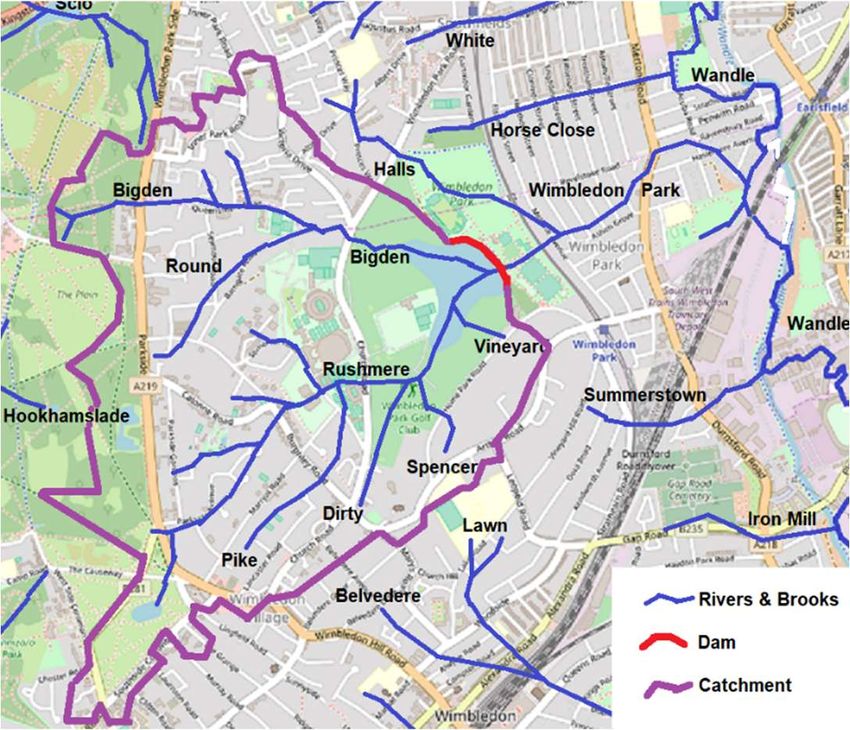
level”) over the next few days. Every few years, however, we get an exceptionally big rainstorm
and the lake rises above the dam crest and flows, out of control, down the dam and into the public
park. This water floods around the café and is stopped by the tube line embankment, which acts
as a dam, holding back the water for some hours. It drains away down the pipe that takes
Wimbledon Park Brook underground all the way to Earlsfield. For public safety, the park has to be
closed. We need to prevent this flooding.
For 130 years, since the tube line was constructed, the flooding of the park has saved the people
who live between the park and Earlsfield from this flooding over the dam. Despite this, because of
the amount of water in the lake and the number of people living in “the grid” downstream, the dam
requires regular engineering inspections. The inspections have not resulted in any statutory
maintenance recommendations and have found no sign of damage, leakage, settlement or
movement. However, 130 years is not enough experience to foretell the flooding future, and
engineering standards are tight. No emergency plan has been published. A recent inspection
called for a study of the effect of extreme rainfall on lake levels and options for improvements in
flood capacity.
This flood study assumed unprecedented rainfall and sought, not only to prevent overtopping flows
flooding downstream, but also to prevent any overtopping from breaching the dam and releasing
the water of the lake all at once. If an implausibly great amount of rainfall is assumed, overtopping
might cause dangerous depths and flows in the public park, and also under the railway
embankment at Revelstoke Road, flowing on and into the Grid. In such an unprecedented storm,
flooding would be widespread anyhow, but the study considered just the contribution from water
overtopping the dam.
Two changes could prevent such out-of-control flooding. The first would be to build a much bigger
overflow, weir, brook and pipe, so that the implausible flood is controlled in the public park and
does not back up so high as to cascade down Revelstoke Road. Normally, these big new
structures would carry no water, or a tiny flow, and only rarely would they be even half full. Making
room for implausible flood flows would cause great damage to the facilities, woody planting and
landscaping of the public park.
The second possible change would be to lower the weir or raise the dam to increase the distance
down from the dam crest to the lake level (the “freeboard”). Visitors to the park would see the
water a metre below the crest of the dam and no-one would live long enough to see it rise even
close to the crest. We would all be safe from that implausibly great rainfall overtopping the dam.
Raising the height of the dam would save the public park from flooding every few years, but at the
expense of flooding the golf course and Wimbledon Club. Lowering the weir would save the public
park from flooding, and also reduce flooding on the golf course and the Wimbledon Club.
The obvious remedy is that the weir should be lowered by at least the 13 inches required to bring
the level down to Brown’s design. This, alone, would be enough to prevent plausible floods from
overtopping. It’s cost-free, and can be done tomorrow, so it’s an obvious priority for action.
Apparently, however, LB Merton has chosen not to do this.
If we must plan for implausible rainfall, lowering the weir may not suffice and we might need to
raise the dam a little and improve the brook and pipes downstream. The weir would have been
lowered and so these engineering works need not be so large and destructive.
Visitors to the park don’t see the silt on the bottom of the lake, but watersports users and anglers
know it’s there. Removing silt would not be cheap; a good job would cost over £7,000,000. Even a
cheaper alternative, that could halve the area of the lake, would cost a fifth of that. So, what’s the
pressing need to turn the lake into a construction site for a year or so, and why does the project
contemplate destroying Capability Brown’s design?
Three reasons have been put forward, but none of them seem sound.
The first reason is the result of a misunderstanding: the project brief says, that de-silting is
required….”to manage the risk of flooding downstream”. This is incorrect; the silt on the bottom of
the lake has no influence on flood risk because it all lies below the level of the outflow weir. The

                                                  2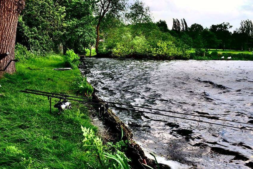
ability of the lake to store flood flows, rather, depends upon its surface area and the freeboard
provided by the height of the dam above the level of the weir.
The second reason is to restore water depth. In the very long term, all lakes slowly silt up, but it’s
taken over 250 years for our lake to lose half its depth. So, we have another 200 years or so
before it silts up. We could buy much more time with silt traps on the three main inflows to the
lake, but these seem not to have been contemplated in Merton’s project. We don’t know why.
The Watersports Centre that uses the lake was established in the early 1970s for inner London
school children without access to good outdoor facilities. We’re told, now, that there’s a problem
with watersports, as masts of capsized boats get stuck in the mud on the lake bottom. However,
this mud was there from the outset and is only around 3 inches deeper now than it was 50 years
ago. Watersports have been enjoyed for 50 years with the depth essentially the same as it is
today. Desilting could increase the water depth by around three feet, 15 times the amount that
would be needed for a return to the conditions when watersports began 50 years ago. The need
for increasing the depth very much more than it has been in living memory is not obvious.
The third reason is to improve water quality. Like many lakes in lowland England, ours is shallow
and nutrient-rich (“eutrophic”). Excess nutrients lead to murky, or even toxic, water. Silts contain
much nutrient, so it was once thought that the return of clear water required the removal of silt.
Incorrectly, Merton still think this. Our lake had murky water in the 1990s, but it cleared around
2011, allowing submerged waterweeds, fish and other waterlife to recover also. A citizen science
project in 2017 found low levels of both phosphates and nitrates in the lake water and the nitrate
levels were much less than in the 1990s. Just what reduced the nitrate concentration, we don’t
know, but research results elsewhere tell us that this was the crucial change. The recovery of
water quality in our lake, without any attention to silt, proves that desilting is not needed for water
quality.
Most of the nutrients are locked away deep in the silt and do not enter the lake water. Last
summer, the Watersports Centre disturbed a lot of silt when removing waterweed from the lake, so
releasing nutrients. This inadvertent experiment produced the expected result: murky water and
blue-green bacteria returned. The lake is now recovering from that insult. Desilting the lake would
stir up much more silt, certainly releasing nutrients which will cause murky water, polluting the lake
and the River Wandle downstream. At least in the short term, this would be the opposite of the
intended result.
Desilting would harm other aspects of the lake. The heritage landscape and biodiversity both
depend upon conservation of the lake’s integrity and shape. These would be compromised should
silt be moved onto nearby land or, even worse, used to reduce the size of the lake. There would
be a loss of irreplaceable wildlife habitat. Flood storage would be compromised should the
disposal of the silt reduce the surface area of the lake. These effects would be contrary to
Government advice on sustainability. Desilting might also distract us from working on the real
issues: improving the heritage landscape, and reducing the amount of nutrients and silt that enter
the lake. These are things that do not seem to have been on the agenda of the “project”.
There appears to be no justification for removing silt from the lake as the harm that this would
cause is clear and the benefits are not established.

                                                   3
Introduction
In 2015, the London Borough of Merton consulted on options for a “masterplan” for their
Wimbledon Park3, which includes the lake. In the background material to the public consultation 4 it
was stated that there would be: “Structural repairs to the dam embankment in response to regular
Panel Engineer reports under the Reservoirs Act to address safety issues.”
Over three years later, although we still await publication of the masterplan, LB Merton are already
planning substantial works to the lake “in line with the Wimbledon Park Masterplan – 2017”. In
October 2017, LB Merton set up a project, the “Wimbledon Park Lake Project (Reservoir Safety
and Desilting)”. This has a website and an exclusive Technical Steering Group which has met
monthly5. The website gives a very brief summary of the purpose of the project. Only in December
2018 was a more “general brief” of the project published:
       The lake in Wimbledon Park dates to 1765 when it was created for the first Earl Spencer as
       the central feature of a landscaped park in front of the family’s mansion house located on
       the high ground up what is now Church Road towards Wimbledon Village.
       Responsibility for design was given to Lancelot ‘Capability‘ Brown, who was, then and still
       now, acknowledged as one of England’s foremost landscape architects. ‘Capability’ Brown
       spent some 20 years transforming the formal Renaissance gardens into a more natural
       landscapes, including building a dam across the valley to convert a marshy stream and
       surrounding bog into an impressive 30-acre lake.
       The lake passed into public ownership in the early 20th Century, when it was purchased by
       the forerunner of Merton Council. Since then the lake has been used primarily as a
       reservoir and for leisure purposes including swimming, water sports and angling. The
       council has a Statutory and legal obligation to maintain the reservoir under Section 10 of
       the Reservoirs Act, 1975.
       Over the 250 years of its existence the lake has acquired substantial quantities of silt and
       the time has now arrived when de-silting needs to take place. This process is required both
       to restore the depth and quality of the water and to manage the risk of flooding
       downstream.
       In anticipation of what will be a complex, multi-layered operation, the Council has
       established a Technical Steering Group to co-ordinate and deliver the required remedial
       works and improvements to the lake to meet its statutory obligations and duties (reservoir
       safety, flood risk, amenities, heritage protection and biodiversity), as well as seeking out
       opportunities to enhance the lake as a key component of the landscape in line with the
       Wimbledon Park Masterplan.
       The Group is composed of representatives from the Merton and Wandsworth Council’s own
       experts in ecology and flood risk, as well as representatives from landowners, leaseholders
       and organisations with specific technical knowledge and skills for such specialist works,
       including the Environment Agency and Historic England.
       Much of the initial work will be centred on the establishing the scope of the project and the
       commissioning of a number of studies to enhance further the understanding of the lake’s
       physical and ecological infrastructure as well as land forms and matters of a historical
       nature.
       It is intended that all surveys will be made publicly available through the council’s website
       once they are complete and signed off for publication6.

The project has a budget of £1,500,000, with a projected cost of £5,000,000 7. Work has been
commissioned for various studies, some of which have been published on the project website 8.
The lake is the central feature of a Grade II* Heritage Landscape, surviving from Brown’s much
larger park9, which I call Heritage Wimbledon Park. This landscape was put onto an “at risk”
register by Historic England in June 201610 “due to uncertainty around the future, the impacts of
divided ownership on landscape management, obscured designed views and the deteriorating

                                                 4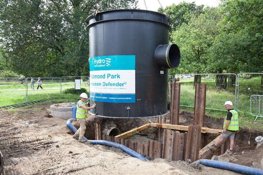
condition of the lake”. This registration aims to keep attention focused on the Heritage Landscape,
to act as a working tool to help define the scale of the problem and to prioritise action by those
who can play a part in securing the future of its irreplaceable landscape.
In any proposed works, government advice is that the principles of sustainable development
should be followed. This should include, amongst other things, ensuring public participation is core
to decision making; giving local communities a greater stake in project design and delivery at an
early stage; creating and linking habitats and promotion of green infrastructure, thus adding to the
total stock of biodiversity, as well as conserving heritage assets and important wildlife sites 11.
Sadly, there has been little attention to these aspects of sustainability in the publications to date.
LB Merton’s masterplan consultation documents in 2015, and freedom of information requests to
LB Merton over the last two years, have not revealed any new safety concern nor any urgent
reason to desilt the lake12. Because the shortage of published information leaves the public
uninformed over the background and reasons for the Wimbledon Park Lake project, this report
reviews information on dam safety, flood risk, the condition of the lake and the effects of “silt” 13
and, consequently, the need for works. This should help to inform interested parties whilst we
await better information and involvement.
The background and history of the lake have already been documented in a report of October
201714. Here, we update that report only where relevant to the condition of the lake, safety and
“desilting”, so those interested in other matters should read the earlier report.

                                                  5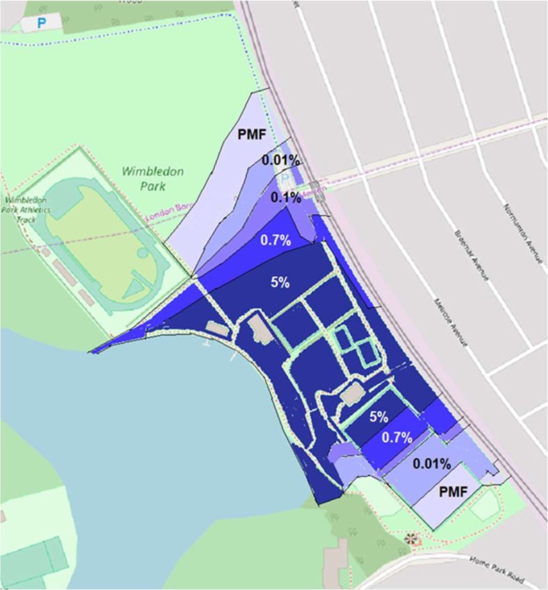
The lake
The lake was created as part of the landscaping, by Lancelot Brown, of the eighteenth century
Wimbledon Park. Brown made a 320 m long dam (red line in Figures 1 & 2) across a wide shallow
                                                 valley where two brooks were confluent: Bigden
                                                 Brook flows from the west and Rushmere Brook
                                                 from the south. The catchment of the brooks
                                                 remains the catchment of today’s lake, but they
                                                 now run in pipes15 underground and flow down
                                                 to the lake from the high ground, which lies west
                                                 and south16. There is also an underground
                                                 drain17 from the All England Lawn Tennis Club18
                                                 and smaller land drains from the golf course and
                                                 The Wimbledon Club. The crest of the dam is the
                                                 lakeside path in the public park. Most of the dam
                                                 is within the public park, but the south-east
                                                 extremity is within the Wimbledon Park Golf
                                                 Course.

Figure 1. The catchment of the lake and historic
Brooks.

The level of the lake is regulated by a sluice at the south end of the dam (Figure 2), whence water
flows into a “stilling” pond within Ashen Grove Wood to enter a pipe. This pipe passes under the
fence between the golf course and public park, turns left and issues by the toilet block in the public
park as Wimbledon Park Brook. It then flows north to receive water also from the waterfall built
into the slope of the dam. There it turns east to flow through a water garden and in pipes past the
café before leaving the park in a large diameter pipe under the tube line embankment. It flows
underground from there for one kilometre to join the River Wandle in Earlsfield.
Heritage Wimbledon Park is split between three owners (Figure 2). The lake is part of the public
                                                   park, owned by the London Borough of Merton.
                                                   Much of its perimeter, however, adjoins the other
                                                   two ownerships: the golf course, which is owned
                                                   by the All England Lawn Tennis Club, and The
                                                   Wimbledon Club. The Wimbledon Park Golf Club
                                                   had a long-term lease on the golf course, now
                                                   bought out by the All England.
                                                   The Wimbledon Park Angling Club19 fish from
                                                   stages on the private shores of the lake (and
                                                   sometimes from a punt). The lake also acts as a
                                                   water hazard in two places on the golf course: the
                                                   seventh and seventeenth holes20. The
                                                   maintenance depots for the golf course and
                                                   Wimbledon Club adjoin the south-west lake shore.

Figure 2. The surrounding owners.

                                                  6
A large green building in the north of The Wimbledon Club covers a tennis court and adjacent to it
is another, temporary, inflatable building used in winter. Both of these are close to the lake edge.
The lake supports various water sports21 for which there are two jetties and two ramps in the
public park midway along the dam. Other water sports facilities include floating rafts in the lake, a
watersports building built into the dam, rooms in the bowls pavilion and storage on the slope down
from the dam crest behind the bowls pavilion. There is a parks depot between the bowls pavilion
and the watersports storage area. The path along the crest of the dam provides access to the
lakeside for public enjoyment.

Flood risk
                                                                The Environment Agency publishes
                                                                risk maps for flooding from
                                                                exceptional rainfall events22. In
                                                                Figure 3, the dark blue shows a
                                                                one-year-in-30 risk of flooding over
                                                                the dam into the public park. The
                                                                light blue shows a one-year-in-100
                                                                risk of such a large flood that it rises
                                                                to escape under the tube line
                                                                embankment at the Revelstoke
                                                                Road bridge to flood suburbs east
                                                                of the park.

Figure 3. The Environment Agency Surface Water
Flood Risk Map.

After a history of loss of life from dam failures in the UK, new requirements for inspection were
introduced in 1930, since when there has been no loss of life23. As a large24, raised reservoir25,
Wimbledon Park Lake is required to have at least one Inspection by an Engineer every ten years26
and annual reports by a Supervising Engineer27. The Inspection Engineer’s report includes
requirements and recommendations, and the Supervising Engineer tracks progress on those and
directs monitoring and maintenance28.
The Reservoirs Act 1975 was amended in 2010 to move the focus away from the size of the
reservoir to the risk that may be posed by dam failure29. In 2015, this led to the categorisation of
Wimbledon Park Lake as a “High Risk” reservoir30. So, inspections must continue and flood plans
must be prepared, to support flood and emergency planning31. No emergency plan has been
published.
One recommendation of the last Inspection of the dam was for a “flood study” to be prepared32.
This study was to examine the effect of extreme rainfall on lake levels and options for
improvements in flood capacity. LB Merton decided to split the study into two parts, the first of
which predicted the effects of extreme events. It was received by LB Merton in April 2018, but has
not been published on the project website. In October 2018, a copy was provided in response to a
freedom of information request33. This provides more detail than is available on the Environment
Agency flood map. The second part of the flood study has not been published to date.

                                                  7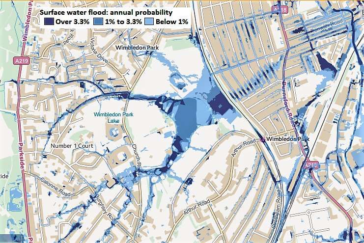
Wave overtopping. The lowest point on the
crest of the dam is only about 28 cm above the
level regulated by the outflow weir34. This
difference is insufficient to prevent waves
sometimes breaking over the top of the dam35.
The lake acts as a balancing reservoir36, in that
flows into it often exceed the capacity of the
outflow, resulting in a rapid rise in level, followed
by a slow decline back towards the regulated
level. The distance down to the lake surface
from the crest of the dam is called the
“freeboard”.
                                              Figure 4. Freeboard measured on 215 days37.
                                              The freeboard averages 18 cm, for which the water
                                              level is 10 cm above the top of the weir.

Because of this slowing of outflow by the weir, the average lake water level is 10 cm above the
regulated level38, reducing the freeboard in the middle of the dam to around 18 cm on average
(Figure 4) and, in the last four years, the lake has risen as high as 20 cm above the regulated
level, leaving only 8 cm freeboard. The limited freeboard means that waves often splash over the
top of the dam.

Figure 5. Waves splashing water over.          Figure 6. Pooling at the base of the dam.

Wave overtopping deposits debris on the path and sends water flowing down the slope of the dam
to flood parts of the public park below39, compromising the park facilities there (Figures 5 & 6).
There has been no published study of this overtopping by wave action but park users can vouch
for the frequency of flooding at the base of the dam.

                                                8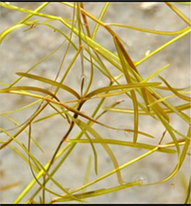
Overspilling. More rarely, a significant rainstorm brings the lake level above the dam crest, so
that water flows over the crest regardless of whether there are waves on the lake or not. This can
result in such significant flooding that the public park has to be closed until the water has safely
drained away. There have been two significant floods requiring closure of the pubic park in the last
ten years40. That such significant overspilling might have been expected was implied by an
engineering study41 in 1993 which examined a “150 year flood”, in which the dam would overtop
by some 6 cm and thousands of cubic metres of water would flood the public park. The
Environment Agency surface water flood risk map (Figure 3) illustrates a similar scenario.
The unpublished first stage of the flood study42 estimated the effect of overtopping from extreme
rainfall events in better detail. Figure 7
summarises the predictions of that
study.
A one in twenty-year flood (5% on
Figure 7) is predicted to flood the
central, low parts of the public park. A,
less likely, one in one-hundred-and-
fifty year flood (0.7% on Figure 7)
would flood a slightly larger area of the
park. With no other outlet, these floods
would drain away over a few hours
through the pipe that takes the normal
flows of Wimbledon Park Brook
underground to Earlsfield. There
would be a risk to life and limb, and
structural damage, from the depth and
flow of the water in the public park, but
the railway embankment would act as
a dam and protect the suburbs to the
east.

                                          Figure 7. The predicted extent of flooding depending
                                          upon the annual risk43.

Three more extreme scenarios44 (0.1%, 0.01% and the Probable Maximum Flood, “PMF” in Figure
7), would flood progressively more of the public park, flow faster and lie deeper. The peak flow
over the crest of the dam in the two most extreme scenarios was estimated to be 7 cm and 26 cm
deep respectively45. All three would rise as far as the Revelstoke Road entrance to the public park,
flow under the railway bridge there and flood the suburbs to the east, much as is predicted by the
Environment Agency Flood Risk map (Figure 3). For these, very unlikely, scenarios there would be
a greater risk to life and limb, and to property, in the public park and a risk outside the park, along
the historic courses of Wimbledon Park Brook and Horse Close Brook (Figure 1).
It appears that current work on phase 2 of the flood study is considering a third extreme scenario,
described as “1 in 100 plus 35% level of flood risk”46, but we have no other information on this.
In such very extreme rainfall events, underground stormwater drains throughout the local area
would be full to capacity and the excess water would flood many other places illustrated in Figure
3, including the valleys of the historic tributary brooks west and south of the lake and extensive
areas around the River Wandle and its other tributary brooks. These floods would carry debris
along with them. So, local flooding would not be solely from the overtopping of the dam in the
park. Nevertheless, the first stage of the flood study concluded that the overflow structure is not
big enough to prevent overtopping and so that safety standards require improvements to allow
safe passage of the two most extreme flood events.

                                                  9
This very high standard for the dam is presumably because of the additional risk should
overflowing water erode the dam and cause dam failure. The Environment Agency publishes
maps of flooding from reservoir failure47 and the relevant map is similar to that for surface water
flooding. No map is available to show the cumulative effect of dam failure and an extreme rainfall
event, but it would be considerably greater than illustrated in Figure 3.
Previously, the level of the lake was maintained well below current levels48. Levels taken in 1884,
1911 and 1932 were 23 cm (9 inches) below the present-day regulated level. Levels now average
9 cm (3.5 inches) above the regulated level (Figure 4 and see above), so we estimate that the
outflow was modified at some time after 1932 to hold the lake level about 31 cm (13 inches) higher
than it was in Brown’s original design49. Anglers report that the regulated level of the lake has
increased over the last fifteen years50. Were the lake lowered to historic levels, we would expect
neither of the most extreme rainfall scenarios to overtop the dam. Clearly, the raising of the lake
above the historic level is responsible for the failure of the lake to meet the requirements for flood
water storage today51.
Lowering the lake to the historic level would also prevent most wave overtopping52.
The high regulated level of the lake, and the variation above this, also cause significant drainage
problems53 in the adjacent Wimbledon Club and Golf Course. The water table in these places is
controlled by the level of the lake, causing flooding when surface and ground water cannot drain
quickly away54. The light blue of Figure 8 shows the extent of land less than 1.5 m above the
regulated level of the lake: it’s there that most flooding occurs because of the high water tables.
Lowering the regulated level of the lake would greatly reduce the problems with drainage.

Figure 8. The extent of low-lying
land around the lake55.

                                                 10
Suggestions to prevent overspilling.
Two engineers’56 reports made suggestions for improvements, perhaps in combination, to allow
safe passage of the two most extreme flood events:
1. Lowering the crest of the dam between the Watersports Centre and the Stadium to allow
overtopping flows across a well-grassed surface, with erosion matting 57, so supplementing
the flows over the weir58.
2. Upgrading and increasing the size of the weir, perhaps by constructing a labyrinth weir in
the lake (Figure 9), and improving the capacity of the existing drains and brook through the
public park and beyond.
3. Armouring the embankment in places and resurfacing the path59, to better withstand
overtopping flows60.
4. Increasing the dam height by up to 1.1m 61, or constructing a wave wall.
These suggestions would have very significant adverse effects on either the public park or the
open spaces of The Wimbledon Club and the golf course. The first two suggestions would
increase the release of flood flows into the public park. In this way, solving one problem,
uncontrolled overtopping, would lead to another problem, having to control more frequent flooding
through the public park. We are not aware of any work to explore this consequence, but we note
that the area considered in recent surveys includes large areas of the public park near the dam
and either side of Wimbledon Park Brook62. This implies that works may be needed in these
significant parts of the public park, probably destroying many trees, shrubs and landscape features
there.
Suggestion 4 would lead to increased flooding of the golf course and The Wimbledon Club,
because exceptional surface water flows would be retained within the lake and cause levels to rise
well above the level of the present-day dam crest 63. The dam would also have to be lengthened at
each end, so extending into the golf course towards the club house at the eastern end and across
the land west of the stadium at the other end.
All works would have to consider the conservation of the European eel, under the Eel
Regulations64.
Subsequently, it appears that a fifth suggestion is being considered: slightly lowering the regulated
level of the lake65. A significant lowering could promote safety, avoid damage to park facilities and
reduce flooding of neighbours, but a slight lowering would have little effect.
Clearly, the promised second part of the flood study should consider the option of lowering the
regulated level significantly, as this is the easiest way to prevent chronic problems of overtopping.
Figure 9. A labyrinth weir. Figure 10. Eroded dam crest on the golf course.
11Other statutory safety recommendations.
We have considered, above, the sole outstanding safety recommendation 66 for the lake. By
statute, reports on inspections of high-risk reservoirs include two further matters:
Matters to be watched for by the Supervising Engineer in her annual inspections 67.
Requirements for monitoring levels and flows and checking the dam for leakages or
settlement68.
In 2014, the Inspection Engineer listed seven matters to be watched by the Supervising
Engineer69. These involved checking the height of the weir and the records of water levels, looking
out for damage, settlement, leakage or movement, maintaining the integrity of the path on the
crest of the dam, and checking screens at the stilling pool and railway culvert. Since the last
Inspection report there have been four Supervising Engineer’s Reports. It’s the job of the
Supervising Engineer to watch and monitor as required by the Inspecting Engineer. The watching
brief has revealed no immediate problems70.
Although the Inspecting Engineer is empowered to make maintenance recommendations under
the Act71, none were made.
In all this, we find no statutory recommendation requiring structural works to improve the safety of
the dam. Despite the implication in the public consultation on the masterplan for the public park,
the engineers’ reports do not state what repairs are necessary, if any.
Non-statutory recommendations. Apart from this statutory watching brief, the Supervising
Engineer also oversees any maintenance which does not require a certificate. In 2014, the
Inspecting Engineer made fully 14 non-statutory recommendations, mainly to facilitate inspection,
check for obstructions, prevent minor incursions of water beyond the sheet piling at the lake edge
of the dam (Figure 10) and to reinforce the embankment against overtopping flows 72. The three
subsequent Supervising visits73 found that valves at the weir and waterfall were working and that
there was not too much debris obstructing flow at the outfall. A gap in the hedge beside the dam
crest path has been repaired allowing the vegetation there to recover and the vegetation either
side of the Waterfall Garden had been mown. However, there has been no progress on half of the
recommendations:
1. Most important, is that no emergency plan has been published.
2. No work has been undertaken to raise the level of the dam crest at the southern end of the
dam and reinstate the ground with an erosion-resistant surface (this was suggested both on
the golf course and on a small area in the adjacent part of the public park). In the absence
of this work, overtopping continues to erode the dam crest.
3. The screens in the stilling pool have not been upgraded.
4. There has been no CCTV inspection of the pipe leading from the stilling pool.
5. A cover of grass no longer than 100 mm has not been established on the downslope of the
dam south of the park depot nor within Ashen Grove Wood.
6. The part of Ashen Grove Wood on the downslope of the dam has not been strimmed
annually to allow checks for movement and seepage.
The failure to upgrade the screens in the stilling pool may be because there was minimal debris on
the three supervising visits. However, observations at other times confirm that much debris
overtops the weir and there is usually a large accumulation on the ad hoc screen at the
downstream end of the pool. It appears that the supervising visits have been insufficient to detect
this problem.
The failure to check the integrity of the pipe risks blockage, which could lead to the level of the
stilling pool rising and the flooding of the public park.
The advocacy of a close-cropped grass slope on the downstream face of the dam and the
strimming of Ashen Grove Wood reflect Environment Agency advice on ease of inspection and
resistance to overtopping flow74. These recommendations, however, appear partial. Features that
12have been engineered or reflect park management are accepted without comment whereas, in
contrast, historic, landscape or wildlife features attract adverse attention.
The part of Ashen Grove Wood on the dam face in the public park is readily inspected 75. The part
in the golf course is also accessible, if with difficulty in places 76. The wood is described, incorrectly,
by the Supervising Engineer as “inaccessible”77. In contrast, the dam face is obscured by stored
materials and built structures at the boat store, park depot, watersports building and the waterfall,
but no works are proposed to make these places more readily inspected.
The vegetation of Ashen Grove Wood provides excellent protection from erosion 78, yet is proposed
for radical change. In contrast, there are other parts of the dam face that are susceptible to
erosion, and not listed in the engineers’ reports79. At Ashen Grove Wood, the combination of the
proposed strimming and the establishment of a grass cover would destroy much of this remnant of
ancient woodland80.
The “weeds” on the dam face in the public park are dominated by Cow parsley and other native
grassland species81; mowing these once a year would prevent invasion by Bramble and by young
trees, but shading by mature trees prevents the development of the “good” grassland cover
desired by the engineers82. Removing most of the trees on the dam face either side of the waterfall
to allow enough light for a grass sward to establish would sacrifice an interesting collection of
trees83. Any remaining trees would be isolated and so at greater risk of wind throw. It appears that
the future of the trees in this area has been debated in the Technical Steering Group84.
In both Ashen Grove Wood and on the slopes near the waterfall the vegetation is well established
and valuable for historic, landscape and wildlife habitat reasons, but is not valued in the
engineering reports. The “removal of the self-seeded saplings on the embankment of the reservoir
…. to meet the safety recommendations” is a perennial item on the agenda of the project
committee85.
These non-statutory engineers’ recommendations
identify the need for some repairs to the dam but don’t
come with a statutory deadline, nor a requirement for
certification, and many of these minor works have not
been undertaken four years after they were
recommended. Clearly the works are not critical or they
would have been included within the statutory
recommendations.
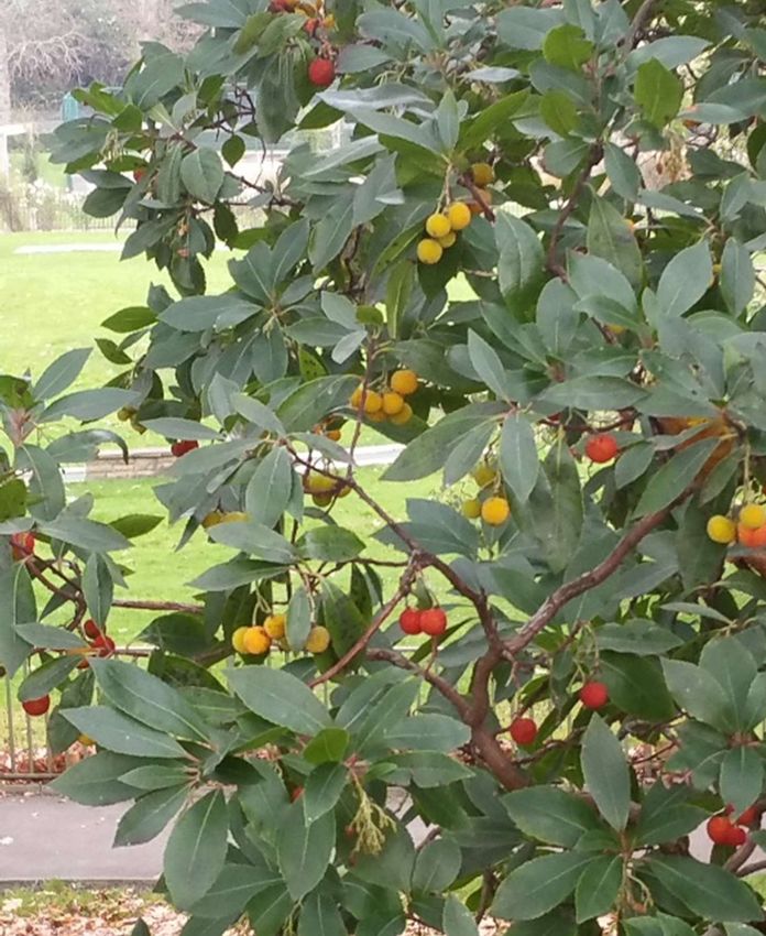
Figure 11. Ashen Grove Wood provides a Figure 12. A fine Strawberry Tree
backdrop to the golf course. on the slope of the dam.
13Sediment in the lake
We use the word “sediment” instead of “silt” because, technically, silt is just one size of particle
that may settle on the bottom of the lake. Most sediment enters the lake in the water from the
AELTC drain (Figure 2) and the two main brooks: Rushmere Brook in the south and Bigden Brook
to the east. The coarse particles settle out
first, giving a sandy sediment near to
where the brooks enter. Further out, the Sediment accumulation at
sediment is of smaller particles, Wimbledon Park Lake
80000
predominantly silt86. Most of the sediment
is rich in organic matter87. 70000
When created in 1765, the lake had an 60000
Sediment volume (m3)
average depth of around 2 m, with its
deepest part around 3.6 m, near the dam 50000
between the watersports jetty and
waterfall outflow88, but much sediment 40000
has accumulated in the intervening 254 30000
years89. The deepest part of the lake is
now around 2.2 m and the average depth 20000
around 1 m. This is a natural process: all
10000
open water bodies slowly accumulate
sediment90. 0
1750 1800 1850 1900 1950 2000 2050
Figure 13. The increase of sediment volume
1765 to 2016.
There have been three recent studies of this sediment 91,92,93, estimating an increase in its volume
from 57,500 m3 in 1998 to 72,000 m3 by 2016 (Figure 6). The average rate of accumulation
between the creation of the lake and 1998 was 250 m3 per annum (or an increase in the average
depth of sediment of 1.3 mm per annum), but this rate seems to have doubled between 1998 and
2008, and further increased to five times the previous average between 2008 and 2015 (7 mm per
annum). If we ignore the likely imprecision of these figures, there has been a substantial and
accelerating increase in the rate of sedimentation in the last 18 years. However, this is based upon
just three estimates, each using different methods and each of which will be subject to
undocumented sampling error. These doubts about the precision of the estimates lead us to take
the recent amount of sediment as one figure (the average of the three recent estimates). For this,
the rate of increase in volume is 265 m3 per annum over the last 250 years (or an increased depth
of 1.4 mm per annum). Sediment now occupies approximately half of the original volume of the
lake, reducing water depth to 1 m on average94.
It’s important to reduce the rate of sedimentation. If the estimated rate of sedimentation between
2008 and 2016 indicates the future, the lake will fill up within 50 years but, if we take the long-term
average rate, it will take 250 years, or more. Clearly these are coarse projections, but they
illustrate the problem. Either way, reducing the build-up will buy us time.
Leaving aside one-off incidents, like the erosion of soil from golf course works in
201595, the main source of sediment is fine particles carried in the three main inflows to the lake.
So, a great reduction in the rate of sedimentation would be possible by installing (and maintaining)
modern “silt traps”96 on the three main inlets sources. Obviously, it is also important to work with
the All England Lawn Tennis Club, golf course, anglers, water sports, caterers and the public, as
any other material entering the lake can contribute to sedimentation 97. This should buy us
hundreds of years before we run out of lake depth.
14Figure 14. A “silt trap” about to be installed to
protect water quality in the Beverley Brook.
Is the sediment currently a problem? “Desilting” is an aim of the Wimbledon Park Lake Project.
The current LB Merton business plan has provision of £1.25 million for this 98, but a Freedom of
Information reply in May 2018 made it clear that flood risk was the main reason for the Project 99.
The current amount of sediment does not materially affect flood risk100.
The consultation on the proposed Masterplan for the public park, in 2016 101, stated there would
be: “An element of de-silting works combined with the creation new areas of wetland habitat along
the edges of the Lake to improve functionality for water-based recreation, water quality and
biodiversity.” The summary brief for the project, cited in the introduction to this report, puts it
differently as to: restore the depth and quality of the water and to manage the risk of flooding
downstream. As long ago as 1998, LB Merton were advised to consider removal of sediment
alongside manipulation of fish populations and other long-term measures, so as to enhance water
quality. The recent “Ecological Appraisal”102 asserted that “silt is exerting an adverse impact on the
lake’s amenity value, water quality, aquatic ecology and has implications for flood risk and
reservoir safety. Leaving aside flood risk and safety, which we considered above and which are
not materially affected by sediment, it appears that the project for “desilting” has three ambitions:
deepening the water to assist water-based recreation, restoring water quality and enhancing
biodiversity.
Water-based recreation. Presumably this ambition is to increase the depth of water, so
increasing the size of boats that can use the lake and area of lake available for some sailing or
boating activities.
The Wimbledon Park Watersports and Outdoor Adventure Centre103 was established around 1970
by the Inner London Education Authority to provide inner London school children with sports
experience not available on their school sites and continues to provide excellent facilities for a
wide range of water-based activity, if no longer readily available for those, otherwise deprived,
school children104. Observations show that canoeing, boating and sailing occur often and across a
substantial part of the lake, especially in the summer, and that those using the facilities come
predominantly from private schools and middle-class households.
The lake has always been too shallow for a sailing boat to turn turtle 105, even the original greatest
depth of 3.6 m was less than the height of a sailing boat mast106 and in as early as 1989 it was
observed that much of the lake was less than 0.5m deep, so restricting recreational activity 107. A
Freedom of Information reply in May 2018 identified the main problem with lake depth as being
that “the masts of capsized boats get stuck in the silt” 108. The future provision of water sports
15activity is being reviewed109, so it would be good to know detail of the extent to which activities are
now constrained by the depth of the water: the historic rate of accumulation of sediment equates
to a reduction of water depth of only 7 cm over the 50 years since the establishment of the centre.
Given the very substantial financial and
environmental cost of “desilting”, it’s important to
understand the operational and social cost that
the sediment imposes upon watersports and the
extent to which improved depth would ease
these. We might hope that this balance would be
made clear in any evaluation of the effects of
“desilting”.
Figure 15. Righting a capsized dinghy.
Water quality. Like most shallow lakes in lowland UK, the lake is eutrophic and so supports
prolific water plants. Such eutrophic lakes have high levels of plant nutrients. When nutrients
increase, a eutrophic lake can switch from clear water with much waterweed to murky water
dominated by diatoms110. Conversely, murky water can be reversed when nutrients are reduced,
but this improvement is influenced also by complex interactions between weather 111, water life and
lake chemistry112. The waterweeds depend upon clear water, which also benefits most species of
fish, amenity and biodiversity, and the waterweeds inhibit the growth of blue-green bacteria, which
can be toxic113. However, when growing in abundance, the waterweed can get in the way of water
craft.
Through most of its history, the lake had good water quality. It sustained a range of fish and the
water was clear. There was much vegetation: floating on the surface, emergent out of the water
and also underwater114. As is common for such shallow, eutrophic, lakes, however, the water
became murky before 1990115. Beds of water lilies were lost116, there was no longer any sign of
waterweed117, and Carp, Bream, Roach and Perch became the dominant fish118. Blooms of blue-
green bacteria were a public health risk in some summers119. A report to LB Merton in 1998120
suggested that the adverse change might have originated with “considerable run off” from recent
building works at the All England Lawn Tennis Club where the drain to the lake had been
constructed in 1985121.
Usually, it’s difficult to reverse such a decline122, as this requires a long-term reduction in nutrients
(usually phosphates, but sometimes nitrates). This less fertile water prevents rapid multiplication of
diatoms, other algae and blue-green bacteria, so light can penetrate the water and allows
waterweed growth. Unusually, in our case, water quality in the lake improved sufficiently after
2011, to allow some submerged waterweeds to recover 123. Then, in 2014, came an abundant
growth of the waterweed, Rigid hornwort, attracting large numbers of Mute swans and Coots to eat
it124. The abundance of hornwort declined somewhat in subsequent years, only for another
waterweed, Small pondweed125, to dominate the water in 2018. The Watersports Centre cut this
weed and dragged it out of the lake, so disturbing the sediment and releasing nutrients into the
lake water that were previously locked away in the depths of the sediment.
16Figure 16. In 2014, when the water was clear. Rigid hornwort (left) thrived. It was succeeded
by Small pondweed (right) in 2018.
Figure 17. When Small pondweed was cut, the water became murky with diatoms, such as
Cylotella (left) and the blue-green bacterium Aphanizomenon (right).
It’s possible that the present concern of LB Merton over water quality is because the abundant
growth of waterweed in 2014 and 2015 got in the way of watersports.
It’s also possible that the concern of LB Merton dates further back to the period of murky water126
before the recent recovery of water quality. A report for LB Merton in 1998127 found high
phosphate, nitrate and nitrite concentrations in the lake, murky water and no waterweed. This
report suggested that the murky water could be redressed by draining the lake and “desilting” it,
followed by restoration with appropriate vegetation, attention to the mix of fish species and control
over Canada geese128. Although none of this has been done129, the lake is now in a much better
state than it was in 1998. It has recovered clear-water conditions without recourse to “desilting”130.
That lake water quality can recover without recourse to removal of sediment finds support in a
recent review of 50 attempts to restore murky lakes back to good water quality, which found little
evidence that sediment removal was an effective restoration method131.
17Whilst this history casts doubt on the need to remove the sediment to improve water quality, just
what caused the recent recovery of water clarity is not immediately obvious.
Figure18. Nutrients in the lake 1989-present: phosphate left and nitrate right132.
Recent investigations (Figure 18) show phosphate concentrations ranging around the threshold for
murky water conditions (0.3 ppm). In contrast, nitrate concentrations were well below the level that
might lead to murky water (9 ppm). Unusually, nitrate seems to be the nutrient that has become
limiting to plant growth in the lake. Recent phosphate concentrations are around the same as
those from 1998 and 2008, but there has been a reduction in nitrate concentrations since 1998.
So, it seems that the switch back to clear water was caused by a reduction in nitrate
concentrations133. To retain clear water conditions and allow the restoration of vegetation and
animal life, we must keep nutrients low. Strangely, there is no mention of nutrients in the
information published by the “project”.
The water was murky in the late 1990s, with
visibility lower than found in recent
readings134. Unfortunately, we have too few
recent measurements to be confident of the
seasonal pattern of lake water clarity, but it
appears that clarity can decline in winter
and recover in early spring. In summer,
however, there was a considerable
difference between 2017, when clarity
remained high and 2018 when the onset of
murky water conditions coincided with the
disturbance of the lake occasioned by the
clearance of Small Pondweed (Figure 19).
Figure 19. Measurements of water clarity with a
Secchi disk135.
Whilst there’s no doubt that long-term recovery of water quality depends essentially upon low
levels of nutrients136, we have no direct information on what caused the reduction in our lake.
Phosphates generally come from sewage pollution, but action on sewerage misconnections after
2016 came too late to account for the recovery137. Perhaps there was action on misconnections
also before 2011? Nitrate is introduced to the lake by birds that feed away from the lake, and
18return to defecate there and from other activities at and around the lake 138, but we have no
indication that any of this has decreased.
The switch back to clear water might have been accelerated, and possibly reinforced, by other
factors:
1. Lower numbers of Carp, Roach and Bream in the lake. The Anglers have observed a major
reduction of fish stocks in the lake in recent years, perhaps as a
result of pollution incidents and poaching139. They point,
particularly, to a reduction of Perch, Rudd, Eel and Roach and
also some poaching of Carp. It’s believed that the slow recovery
of some lakes after improvements in the quality of inflows may
reflect the time taken to deplete the available140 store of
phosphorus in the sediment. The top few centimetres of the
sediment can be stirred up into the lake water by wave action or
by bottom-feeding fish, such as Carp, Bream and Roach and
this may increase the dissolved nutrients. Another effect of the
fish is that they eat the planktonic animals (such as water
fleas)141. These animals eat the diatoms, so preventing diatoms
from becoming so numerous as to make the water murky. Most
species of fish eat the planktonic animals, but particularly Roach
and Bream142. So, poaching of Carp, and pollution effects on
Roach and Bream, inadvertently could have helped with water
quality.
Figure 20. The Long-spined water-flea,
responsible for most consumption of diatoms.
2. Increased predators or parasites of fish. The adverse effects of bottom-feeding and
plankton-feeding fish could be offset if those fish were depleted by predators or parasites.
Of the bird species that take fish, Grey herons, Common terns and Cormorants have
increased at the lake since the mid 2000s, but Great-crested grebes have declined 143.
Large predatory fish, such as Pike and possibly Perch could depress the numbers of other
fish species144. The anglers report that Pike are being caught in higher numbers than
before. So, it’s possible that predatory birds and fish have helped the lake water quality to
recover by reducing the numbers of problem fish.
3. In two years around 2008-9 Mid Kent Fisheries were employed by LB Merton (Parks and
Sailing Base) to reduce the bulk of the sediment with “Siltex” 145, a propriety finely ground
chalk that is claimed to enhance water quality. This chemical treatment possibly helped the
switch back to clear water, although the five year delay between the treatment and the
great growth of waterweed casts doubt on this possible cause.
Biodiversity
The third aim of the proposed “de-silting” works is “biodiversity”.
The natural habitats and species supported by the lake and its surrounds are well known, but the
project commissioned a further study, a “Preliminary Ecological Appraisal” with new field work and
a “desk study”146. The field work was undertaken too early in the year, over too short a time period
and with uneven coverage, so it found almost nothing new. The appraisal’s rehash of existing
information was done uncritically, with good comprehensive sources listed side by side with poor
information, as if the two were equally valuable. This was compounded by an evaluation using
criteria and procedures differing from those adopted in London. The sole strength of the appraisal
was a tick box approach to evaluate the presence or likely presence of specially protected habitats
and species, with recommendations for further work on these and protection during the works 147.
Even here, by concentrating on special protection, the appraisal fails to give enough emphasis to
19the recommendation for positive action in designated sites and for priority habitats 148. Because of
the limitations149, I do not refer much to the appraisal here, preferring to rely upon the considerably
better existing information, much of it from my own work over the last 35 years 150.
The lake and most of its surrounds are included in a Grade I Site of Borough importance for nature
conservation, a judgement made in 1998151 and reflected in the LB Merton Local Development
Plan, and following guidance from the Mayor of London. The next nearest sites of equivalent or
greater wetland value are so distant that this site is the nearest place of such value in an area of
some 35km2 in the London Boroughs of Merton, Wandsworth, Lambeth, Sutton and Kingston-
upon-Thames152.
This value depends critically upon the nature of the wildlife habitats of the area 153. The lake and its
fringing vegetation, including wet woodland, contribute significantly to this value, providing habitat
for many of the species found at the lake. The wet woodland fringe is a National Priority Habitat 154
type in biodiversity action planning, so deserving protection and enhancement as a contribution to
national biodiversity conservation. Here, it also provides microclimatic conditions for the insects
that emerge from the lake which, in turn, attract aerial foraging animals (see below) and it screens
the lake from light pollution, allowing use by species that require dark skies, including some of the
bat species of the area. Strangely, the Preliminary Ecological Appraisal failed to identify wet
woodland and mapped it as “scattered scrub”, so missing its considerable ecological importance.
A small area of ancient woodland, Ashen Grove Wood, adjoins the eastern corner of the lake and
Owl Copse the western boundary, enhancing the wildlife value in much the same way as does the
wet woodland elsewhere. There are several ancient or veteran trees on the lakesides 155
The previous section outlined how clear water conditions permit a diversity of plant and animal life
to thrive in the lake: this is biodiversity. So, the previous section describes how to maintain and
enhance biodiversity in the water of the lake. The European eel, which is listed as Critically
Endangered, is among those supported by the lake and requiring sensitive treatment to avoid
further harm to the species156.
Beyond the direct effect of clear water on life within the lake, there are effects further away.
Specially protected aerial foraging species (such as bats and swifts) commute long distances to
feed on the abundant insects that emerge from the lake, returning to their nests and roost sites
across a wide area of south-west London, enhancing the biodiversity there. This attraction of the
lake makes the area one of the top sites in south London for such species. Many of the waterbird
species that use the lake depend upon it for only part of their annual cycle, so the other places that
these species visit benefit indirectly from the
sustenance provided by the lake. In this way, good
water quality will increase the diversity of both the
aerial foraging and migrant species that visit the
lake157. The Site of Importance is, therefore, an
important “Stepping Stone158” for biodiversity. Public
access to the lake, made attractive by the biodiversity
there, enhances broader “ecosystem services”,
including health and wellbeing159.
Figure 21. Daubenton’s bat is one of 7 species160
that are attracted to the heritage landscape by
the abundance of food from the lake.
These biodiversity benefits of the lake exist now and there’s no evidence to suggest that they
would be particularly enhanced by any changes resulting from removal of sediment. Indeed, the
next section suggests that substantial harm could result.
20You can also read