Management Plan for Anguilla's Marine Park System and Associated Shallow Water Habitats and Fisheries (2015-2025)
←
→
Page content transcription
If your browser does not render page correctly, please read the page content below
Management Plan for Anguilla’s Marine Park System and Associated Shallow Water Habitats and Fisheries

    Management Plan for Anguilla's Marine Park
  System and Associated Shallow Water Habitats
                         and Fisheries (2015-2025)

                                           Prepared By:
                       Department of Fisheries and Marine Resources
                 Government of Anguilla P.O Box 60 The Valley Anguilla B.W.I
                                 Email: fisheriesmr@gov.ai
                              Telephone: (264)497-2871/8705
                                    Fax: (264)497-8567

                                                                                                        1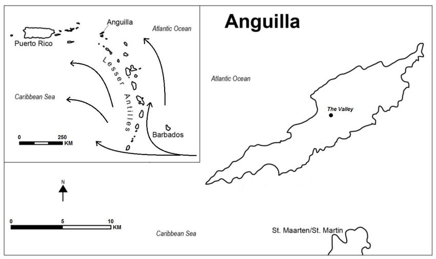
Management Plan for Anguilla’s Marine Park System and Associated Shallow Water Habitats and Fisheries

  This document is a consolidated version of Wynne S.P. (2015) ‘Developing an Adaptive Management Plan for Anguilla’s Marine Park System and
       Associated Shallow Water Habitats and Fisheries (2015-2025)’, which is an adapted version of Chapter 5 taken from the Ph.D. thesis:
‘Developing management strategies against regional eutrophication in Caribbean small island nations with limited financial and logistical resources’
                                                                  (Wynne, 2016).

             This second consolidated version is designed to be a working adaptive document and as such will be updated periodically.

                                                            LAST UPDATE MAY 2017

 Preferred citation for this version: Wynne S.P. (2017) Management Plan for Anguilla’s Marine Park System and Associated Shallow Water Habitats
            and Fisheries (2015-2025). Produced by the Department of Fisheries and Marine Resources for the Government of Anguilla.

                                                                                                                                                  2
Management Plan for Anguilla’s Marine Park System and Associated Shallow Water Habitats and Fisheries
Table of Contents
Executive Summary . . . . . . . . . . 5
Section 1 – Introduction . . . . . . . . . 7
A Brief History of Anguilla’s Marine Park System 8
Management of the Marine Park System 11
Historical Record of Marine Management Plans 12
Historical Record of Ecological Data Collection 14
Scope and Successful Implementation of this Management Plan 18
Section 2 – Legislative and Managerial Structure . . . . . 21
Management and Managerial Structure 23
Section 3 – Management Plan . . . . . . . . 25
Marine Park Descriptions Breakdown of Goals for Each Area 27
Other Managerial Units 33
Section 4 - Legislative Amendments . . . . . . . 35
Proposed Amendments to the Marine Parks Act and/or the BHCA 35
Proposed Amendments to the Fisheries Protection Act 37
Other and/or Non-Legislative Management Actions 39
Section 5 – Implementation Time-line: 2015-2025 . . . . . 45
References Used and/or Cited in Text . . . . . . . 49
3Management Plan for Anguilla’s Marine Park System and Associated Shallow Water Habitats and Fisheries
List of Acronyms Used
ACRAMAM - Anguilla Coastal Resource Assessment Mapping and Monitoring Project
AFDP – Anguilla Fisheries Development Plan
AMMA – Anguilla Marine Management Area
AMMP – Anguilla Marine Monitoring Programme
ANT – Anguilla National Trust
ARDP – Anguilla Resources Development Project
AXA CRIS – Anguilla Coastal Resource Information System
BHCA – Biodiversity and Heritage Conservation Act
CZFMA – Coastal Zone Fisheries Management Area
DFMR – Department of Fisheries and Marine Resources
DoE – Department of Environment
DoPP – Department of Physical Planning
EFZ – Exclusive Fisheries Zone
GWE – Green Water Event
IBA – Important Bird Area
OTEP – Overseas Territories Environmental Programme
4Management Plan for Anguilla’s Marine Park System and Associated Shallow Water Habitats and Fisheries
Executive Summary
Anguilla’s Marine Park System was officially established in the early 1990s, but to date no
management plan has been implemented to facilitate the reaching of the marine parks intended
goals. Despite the production of a draft management plan in 2001, unaddressed legislative
insufficiencies ultimately led to it not being officially adopted and continued managerial stagnation.
These legislative inadequacies have been identified as:
No officially designated managerial agency.
Incorrect and/or ambiguous designation of which areas are true marine parks.
Insufficient regulations within the Marine Parks Act and other legislation.
Since its establishment, the Department of Fisheries and Marine Resources (DFMR) has assumed
an ad-hoc role in the management of these areas, working within the limited legislation as it
currently stands. Despite limited financial and logistical resources, DFMR has spent over a decade
filling the knowledge gaps necessary to produce a comprehensive management plan. It has also
developed a strategy to overcome the legislative road block that has prevented the success of past
initiatives, in the hope that it will kick-start the long overdue managerial process essential for the
success of the Anguilla Marine Park System.
The strategy put forward is for DFMR to continue its assumed management role for the marine
parks until they are named legally as such, but to do so in a more assertive manner by taking the
lead role in the design and implementation of this management plan. Headed by DFMR, other
members from key government agencies, non-governmental organisations, and stakeholder group
representatives will be involved to ensure the cross-disciplinarian nature of this initiative is
addressed effectively. Through this means DFMR will strive to effectively achieve the
administrative success of this plan and ensure, to the best of its ability, that all necessary legislative
changes are made to allow this.
The management plan has been designed to allow Anguilla’s Marine Park System to reach its
originally intended potential, that being ‘To protect fish, flora and fauna found in the park areas
5Management Plan for Anguilla’s Marine Park System and Associated Shallow Water Habitats and Fisheries
while preserving and enhancing the natural beauty of such areas’ (statement first published in
Policy Statement on Marine Parks for Anguilla, Government of Anguilla, c.1978). The overall goal
is to reduce anthropogenic pressure on the degraded nearshore ecosystems through effective
management of visiting tourists, coastal developments and extractive fishing activities. In terms of
this latter pressure, a long term strategic plan is to encourage the development of offshore fisheries
resources, a goal that this plan aims to achieve in combination with a sister document, the Anguilla
Fisheries Development Plan (Gumbs et al., 2015). For this reason, and due to the inherent
intricacies and interactions between marine areas, the management of marine parks also needs to
consider surrounding marine environments, and (at least in part) their associated fisheries. Key
management actions identified within this plan include:
Unification of all current marine protected areas around Anguilla into the Anguilla Marine
Park System.
Fishing restrictions to be imposed within park boundaries.
Protection of dive sites and other important tourist attractions both within park boundaries
and in surrounding areas.
Tourism enhancement within the marine parks to attract more paying visitors, combined
with a review of the marine park user permit fee structure.
Production of outreach materials aimed at education and awareness of the marine parks and
their role in livelihood sustainability.
Additions made to fisheries legislation outside of the Marine Parks Act, including (but not
limited to) the introduction of closed seasons for Lobsters and Conch and minimum size
limits for certain fish species and/or amendments to existing size limits. These changes will
apply to all marine areas, not just those within the marine park system.
Strict enforcement of Fishery Protection Act in nearshore regions (Coastal Zone Fisheries
Management Area) to create a buffer zone that will link the marine parks with surrounding
coastal regions.
Based around current financial and logistical constraints, the area that can realistically be
regularly patrolled by the marine police and/or DFMR to become known as the Anguilla
Marine Management Area (AMMA).
A ten year initial structured plan of action with annual revised editions of this plan produced
bench-marking adaptive management intervals.
6Management Plan for Anguilla’s Marine Park System and Associated Shallow Water Habitats and Fisheries
Section 1: Introduction
Anguilla (18°12.80N and 63°03.00W), is the most northerly of the Lesser Antilles leeward island
chain and forms part of the British West Indies (Figure 1), with a comprised area of 91 km2. It is a
flat, low-lying island formed mainly of uplifted fossil corals surrounded by a variable shelf with
several uninhabited offshore cays. The largest of these cays include Sandy Island, Dog Island,
Prickly Pear Cays, Seal Island, Anguillita Island, Scrub Island, Scilly Cay, and the distant Sombrero
Island. These islets support a variety of reef habitats, the majority of which are fringing, with the
largest of which running from Prickly Pear Cays almost parallel to the mainland north coast for a
distance of approximately 10 km. The crest of this reef breaks the surface in a number of places and
runs down to a depth of 15 m or more. The northern leeward coast of Anguilla is characterised by
extensive patch reefs interspersed with sand flats and seagrass beds. The south coast historically
housed extensive fringing Acropora spp. reefs, the vast majority of which are now severely
degraded. There are also extensive seagrass beds in the area. There are over forty beaches around
the island and its offshore cays, most of which consist of white sand derived from fine ground coral
remains and Halimeda spp. fragments. Seven marine parks are currently recognised in Anguillian
waters, five of which form the Anguilla Marine Park System: Three of these parks surround the
offshore cays of Dog Island, Prickly Pear Cays and Sandy Island, one encompassing the patch reef
system of Shoal Bay and Island Harbour, and one in the seagrass regions close to Little Bay. Areas
around Sombrero Island and Junks Hole are also legally marine parks, but are more important as
heritage sites rather than of ecological significance. An eighth protected area not legislated
officially as a marine park is at Rendezvous Bay. This important seagrass area has recently been
adopted by DFMR as a marine park but has yet to be fully encompassed in the Marine Park System.
A number of dive sites, including seven purposefully sunk ship wrecks, exist around the island but
are under no official protection. Currently no formally adopted management plan exists for these
areas, although it has long been recognised that this is a management gap that urgently needs filling.
It is the objective of this report to do just this, not just for a fully unified Marine Park System, but
also for the associated fisheries and other shallow water habitats. The legislative situation is
clarified further in the following paragraphs.
7Management Plan for Anguilla’s Marine Park System and Associated Shallow Water Habitats and Fisheries
Figure 1: Anguilla situation map, illustrating geographical location and prevailing currents.
A Brief History of Anguilla's Marine Park System
Although the original Marine Parks Ordinance was produced in 1974, with draft regulations
produced c.1978 (Gov Axa, c.1978), it is usually documented that Anguilla's marine parks (Figure
2) were originally designated under the later Marine Parks Ordinance of 1982 (Lum Kong, 2008).
This Ordinance was again superseded by the Marine Parks Act (2000) which was revised again in
2010 following previous amendments in 2007. However, the parks actual designation is more
officially cited as occurring in 1993 (CaMPAM, 2010) when the Marine Parks Regulations came
into force. Under the regulations one marine park was listed for demarcation, the Junks Hole
Marine Park - the waters surrounding the site where the wreck of the Spanish Galleon El Buen
Consejo is situated. Notwithstanding this, the Junks Hole Marine Park is not usually cited as part of
Anguilla's Marine Park System as it is more recognised as a heritage site rather than being of
ecological importance.
The five areas normally cited as being part of Anguilla's Marine Park System were not designated
under the Marine Parks Act until the amendments made in 2007. Instead, four (Dog Island, Sandy
Island, Little Bay and Prickly Pear) were listed within the Cruising Permit Act (1980, later
superseded in 2000) as areas with anchoring restrictions. Also listed in this Act is Rendezvous Bay
8Management Plan for Anguilla’s Marine Park System and Associated Shallow Water Habitats and Fisheries
which, until recently, was not considered a marine park and thus not part of the Anguilla Marine
Park System. These five areas would therefore have been better described as marine protected areas
until 2007, rather than marine parks as they were technically only under anchoring restriction. Shoal
Bay-Island Harbour has never been listed under the Cruising Permits Act and so only became a true
protected area when it was listed under the amended Marine Parks Regulations in 2007. Despite this
Shoal Bay-Island Harbour has always been considered part of the Anguilla Marine Park System. It
remains unclear how this area was originally designated as no mention of it has been found in the
legislation prior to the 2007 amendment. It is thought this area was instead listed in the Government
of Anguilla’s official Gazette, although confirmation and publication date of this has not been able
to be obtained. In 2010 the revision of the Marine Parks Act added Sombrero Island to the list of
marine parks. Currently Rendezvous Bay is the only area listed in the Cruising Permit Act that is
not listed in the Marine Parks Act.
This legislative confusion has led to it sometimes being cited that (prior to 2007) Anguilla did not
have any marine protected areas (Lum Kong, 2008) even though the areas listed under the Cruising
Permits Act were afforded some protection and Junks Hole Marine Park was designated under the
Marine Parks Act. Furthermore, these areas, as with all of Anguilla's marine systems, were also
subject to the generic protection afforded by the Fisheries Protection Act (2000). Such restrictions
under this legislation include (but are not limited to) fish pot mesh size, size limits for the Panulirus
argus and Strombus gigas1 fisheries, and controls on all turtle fisheries.
For the purpose of this document, Anguilla will be considered to have eight marine parks: six
designated for ecological purposes; one (Junks Hole) designated for heritage purposes; and one
(Sombrero Island) for heritage and potential ecological purposes, pending marine survey work. As a
final clarification, until only a few years ago, Rendezvous Bay was not considered a marine park
but rather an area under special management, and so not included in Anguilla’s Marine Park
System. This is no longer the case however as it has now been adopted as an unofficial marine park
and hence included within this management plan. To avoid future confusion, one of the main
recommendations under this management plan will be to unify the legislation governing marine
systems and to ensure all these areas are correctly listed under the Marine Parks Act.
1
Now reclassified as Lobatus gigas
9Management Plan for Anguilla’s Marine Park System and Associated Shallow Water Habitats and Fisheries Figure 2: Map of Anguilla illustrating locations of marine parks, including Rendezvous Bay and shallow water areas (
Management Plan for Anguilla’s Marine Park System and Associated Shallow Water Habitats and Fisheries

                               Management of the Marine Park System

Current management of the Marine Park System, including Junks Hole Marine Park and
Rendezvous Bay, is the responsibility of the DFMR, not because it is the official managing agency
(none has yet been designated), but rather due to the Department's general mandate of promoting
sustainable use of the marine environment. Furthermore, DFMR’s quasi-managerial role has
necessitated an ad hoc approach as no official management plans exist for these areas (OTEP
ANG402, 2007). As part of this assumed management role DFMR installs and maintains mooring
fields in three of the marine parks (Prickly Pear, Sandy Island and Little Bay), with plans to extend
this to Shoal Bay-Island Harbour. In a similar way, on top of its regular mandated work, DFMR also
conducts regular beach monitoring surveys, which although technically (or at least partially) outside
of their jurisdiction, they conduct for similar reasons as they do the management of marine parks.

This lack of designation of an official management agency is largely due to the inevitably complex
political nature of small island developing states such as Anguilla, especially when considering the
management of areas with jurisdictional cross-overs and their multi-disciplinary nature. For
example, DFMR is mandated to manage marine and coastal resources only up to the high water
mark, with other agencies responsible for terrestrial areas (for example the Department of
Environment, Anguilla Air and Sea Ports Authority, etc.). For this reason, it is likely that for the
successful management of these areas, new legislation or amendments to existing legislation will be
needed. This appears to be one of the functions behind the Biodiversity and Heritage Conservation
Act, which deals with the multi-disciplinary nature of marine and coastal systems by jointly
assigning the administration of this Act between the Minister of Fisheries and Marine Resources
and the Minister of Environment. This is the first jointly administered Act in Anguilla and
potentially paves the way for more unified and successful management of protected areas: where
the Minister of Fisheries and Marine Resources is the competent Minister with respect to aquatic
species, their habitats, and protected areas that are established and maintained to primarily protect
aquatic species and their habitats; and the Minister of Environment is the competent Minister with
respect to terrestrial species, their habitats, and protected areas that are established and maintained
to primarily protect terrestrial species and their habitats. Until the production and enactment of the
BHCA regulations the full implications of this Act remains unclear, although problems relating to
the lack of an official management agency may be resolved. Prior to this taking place, or prior to
the Marine Parks Act naming DFMR as the lead agency, their ad hoc role will continue.

                                                                                                           11
Management Plan for Anguilla’s Marine Park System and Associated Shallow Water Habitats and Fisheries
Historical Record of Marine Management Plans
Although management plans have been produced in the past, none have officially been adopted for
Anguilla's Marine Park System, or indeed any of Anguilla's Marine habitats and/or fisheries.
According to Oxenford & Hunte (1990), the Anguilla Resources Development Project (ARDP)
conducted in 1980 was one of the first steps towards the management of coastal resources and
habitats in Anguilla. This work, initiated by the Government of Anguilla and the Eastern Caribbean
Natural Area Management Programme resulted in three reports: Salm (1980); Olsen & Ogden
(1980); and Jackson (1981). This latter report proposed a preliminary management strategy for
Anguilla's critical marine resources and essentially became Anguilla's first marine management
plan. This plan also contained the first recorded management zonation map for Anguilla's
immediate marine areas and cays, and proposed national marine parks at Sandy Island and Shoal
Bay East together with a number of other multiple use zones with varying degrees of protection
and/or management. As a side note, a policy statement on marine parks for Anguilla (Gov Axa,
1978), which was probably still being discussed while Jackson collected his field data, although not
a management plan, did suggest four areas around Anguilla be established as marine parks: the reefs
around Sandy Island; the waters around Prickly Pear Cays; the reefs and waters at Little Bay in the
Flat Cap Point region; and the reefs around Shoal Bay East.
The work by Jackson, combined with reports of habitat degradation in other parts of the Caribbean,
led to an increasing recognition of the urgent need to manage Anguilla's coastal resources
(Oxenford & Hunte, 1990). Indeed, the importance of protecting coastal marine resources was
stressed further in the 1987-1997 Fisheries Development Plan for Anguilla (Stephenson, 1987).
Thus a program was initiated to establish a number of marine protected areas around the island, and
an action plan produced by Jackson (1987) laid out a road map for the development of marine
parks. This action plan used the same zonation plan as his earlier 1981 paper, which was again used
(Goodwin, 1989) in a simplified form by in what appears to be a sister project conducted by the
Caribbean Conservation Association, the same body who requested the action plan produced by
Jackson (1987). Goodwin cites a number of unavailable reports that appear to have been assessing
the various areas around Anguilla being proposed as protected areas (namely: Dog Island;
Sombrero Island; Seal Island; Prickly Pear Cays; Scrub Island; Shoal Bay East; Sandy Island;
Corito Bay; and Little Harbour).
12Management Plan for Anguilla’s Marine Park System and Associated Shallow Water Habitats and Fisheries
The marine park areas that were eventually established in 1993 were only partially complimentary
to those proposed by Jackson (1981) and Goodwin (1989), and as such the zonation plan became
somewhat outdated. At the same time though, Jackson’s rationale was still being used as a general
guideline for the development of management approaches for the coastal resources of Anguilla up
until Oxenford and Hunte (1990), and on into the mid-late 1990s. The work conducted by Oxenford
and Hunte does give detailed descriptions of Jackson’s recommendations and contributes a number
of suggestions as to how to update the work based on the ecological monitoring they conducted.
Despite this, and their recommendations for management of marine resources at their study sites,
Oxenford and Hunte did not describe a detailed management strategy for the island and thus no up-
to-date management plan was in effect during the establishment of the marine parks in 1993.
Regardless, it is generally agreed that the marine parks are located in optimum locations, although it
may have been beneficial to have included additional areas in the Marine Park System (Scrub
Island and Anguiltia Island-Blowing Rock, for example).
A decade later in 2001 a new management plan was produced for Anguilla's marine parks
(Hoggarth, 2001). It was prepared for the Organisation of Eastern Caribbean States Natural
Resources Management Unit in St Lucia, under a project funded by the Department for
International Development in the Caribbean. No known record exists of the Government of
Anguilla directly requesting the production of this plan although acknowledgements of help are
given to members of DFMR and other stakeholders. The plan, based on seven days of research in
Anguilla and those data available at the time, is a thorough attempt at organising action towards the
management of Anguilla's marine parks, although the plan itself was never formally adopted. The
plan is cited as being a draft interim management plan only, and states that “this management plan
should be regarded only as a first attempt at describing the status and management of Anguilla’s
marine parks”. It goes on to say that “As guided by the terms of reference, the main focus was
placed on assessing needs for monitoring the status of marine habitats. In this and other areas, much
further analysis, consultation and design remains to be done”, and “This interim plan should be
upgraded to a first full management plan upon completion of a further participatory planning
process as described in the following sections. Anguilla’s marine resource stakeholders need to
agree the future goals and institutional arrangements for the marine parks system, and the
objectives, zonation, and regulations specific to existing parks and any new parks” (Hoggarth,
2001, page 6).
13Management Plan for Anguilla’s Marine Park System and Associated Shallow Water Habitats and Fisheries
At the time of its writing, the 2001 management plan was based on the ecological data collected by
Oxenford and Hunte (1990) and recognised the fact that these data were in need of updating and as
such that the initiation of a long-term monitoring scheme be of immediate and utmost importance.
Thus, although this interim plan was not upgraded directly as recommended, it may have
contributed to the priority that DFMR placed on collecting such data five years later (see following
Section). Furthermore, the relative completeness of the plan means it is an ideal foundation for the
current management plan being developed and, as such, this plan may be viewed as the upgraded
version that Hoggarth recommended.
Historical Record of Ecological Data Collection
The earliest known report specifically aimed towards fisheries management in Anguilla was
authored by Camacho R.V. (1974). As no known copies of this report were able to be located it is
unclear whether any data were collected as part of its production. It is, in fact, unlikely that they
were as a later report by Olsen and Ogden (1980), the earliest known surviving report orientated
towards fisheries management in Anguilla, states that “there has been little previous work in
Anguilla” and that “These fisheries are poorly known since they have been largely overlooked by
the United Nations Development Project of the 1960's and have not been visited by the Western
Central Atlantic Fisheries Common which has recently produced many useful analyses of the
fishery potential of many of the Caribbean Islands” (Olsen & Ogden, 1980, page 3). As fisheries
were themselves of prime concern back then, and little attention given to the habitats that they
existed in, it is unlikely any ecological data had, at that time, been collected. Indeed, as Olsen and
Ogden (1980) were part of the ARDP that also yielded the preliminary management strategy put
forth by Jackson (1981), it is also highly probable, albeit not possible to confirm, that the zonation
map proposed was not based on any ecological data either, although it did describe the nearshore
marine resources and recommend a system of marine parks (Oxenford & Hunte, 1990). Also falling
under the umbrella of the ARDP, the surveys conducted by Salm (1980) and outlined in his
associated report, although representing the first known work on Anguilla’s reefs, are believed to
have contained mainly qualitative descriptions with only limited quantitative data. Reef Watch
(1989, page 1) writes “Both the north and south coasts have fringing and patch reefs, together with
coral assemblages on limestone terraces (Salm, 1980). The terrace assemblages are more extensive
in the south, forming a 17 km reef area which was considered by Putney (1982) to be one of the
14Management Plan for Anguilla’s Marine Park System and Associated Shallow Water Habitats and Fisheries
most important largely unbroken reef areas in the Eastern Caribbean. These southern reefs are
however more exposed to hurricane generated damage as is evidenced by the higher percentage of
dead and broken coral recorded by Salm (1980). From the limited published information available,
the northern reefs seemed to support a higher percentage cover of living coral with fields of intact
Acropora palmata and Acropora cervicornis”.
Based on the recommendations from the ARDP, the Government of Anguilla selected a number of
candidate sites for consideration in the management scheme. These sites included Prickly Pear/Seal
Island, Sandy Island/Dowling Shoal, Shoal Bay, Island Harbour, Black Garden Bay, Crocus/Little
Bay, Little Harbour, Corito Bay, Forest Bay, Sandy Hill Bay, Dog Island, Scrub Island, and
Sombrero Island (Oxenford & Hunte, 1990). This led, in 1989, to a Cambridge-Anguilla Expedition
that was mounted to examine marine habitats, initiate permanent monitoring sites and make
management recommendations for the first three of these areas. This expedition collected data at
these sites (Shoal Bay, Sandy Island & Prickly Pear/Seal Island), although surveys were relatively
generic in nature (Reef Quality Index; Environmental Impact Index; substrate type by depth and by
site; grouper species abundance; surgeonfish abundance; angelfish abundance; and butterflyfish
abundance). The report from this work only presents analysed data and hand drawn maps and so
only limited quantitative temporal comparisons are possible.
The Government subsequently requested assistance from the British Development Division to carry
out a 'Coastal Inventory and Analysis Project' to examine the remaining candidate sites and to
develop a management strategy. The project administered by the then Department of Agriculture
and Fisheries, and conducted by the Bellairs Research Institute of McGill University in Barbados
(Oxenford & Hunte, 1990), is the result of this request and represents the most rigorous known
surviving marine and coastal ecological data for Anguilla during this period. Surveys were
conducted at eight of the candidate sites (Black Garden Bay; Crocus/Little Bay; Little Harbour;
Corito Bay; Forest Bay; Sandy Hill Bay; Dog Island, and Scrub Island), which diverged somewhat
from what appeared to be the general site consensus of the time. Unfortunately this work did not
cover Shoal Bay, Sandy Island or Prickly Pear, a fact that may be due to the Cambridge Expedition
having surveyed these areas the year earlier. As it appears that this expedition was less rigorous in
data collection than Oxenford & Hunte, information at these sites from the time is more limited. It
is unknown if more detailed data were presented in a final report of this 1989 expedition as only an
informal draft is currently known to exist. For these reasons it is only the Oxenford and Hunte data
15Management Plan for Anguilla’s Marine Park System and Associated Shallow Water Habitats and Fisheries
that were used by Hoggarth (2001) to develop the first detailed management plan for Anguilla,
which means significant knowledge gaps were present as only two of the five marine parks (Little
Bay and Dog Island) had any detailed available data. These Oxenford and Hunte data are still used
today for temporal analysis of those sites surveyed during the study (Wynne, 2010).
Following Oxenford and Hunte, in 1995 the coastal and sub-littoral habitats of the islands and reefs
were surveyed and mapped under the Anguilla Marine Resources Inventory Project by rapid ground
truth data collection using aerial photography from 1991 (Blair-Myers et al., 1995). The output of
this project provided the most accurate map of Anguilla's benthic environments at that time and was
used extensively during the following two decades as the definitive reference material for planning
decisions. In 1995 Hurricane Luis hit Anguilla and, according to an impact assessment study
(Bythell & Buchan, 1996), significant damage to the coral reefs and seagrass beds occurred. This
study used a methodology identical to that of Blair-Myers et al. (1995) so to allow realistic
continued use of the benthic habitat map. The scale of these two projects, combined with the
necessary rapid approach to surveying, does however mean that no detailed quantitative data were
produced.
Early the following decade limited survey work that formed part of the Reef Check initiative was
conducted on a reef 100m north of Blackgarden (Hoetjes et al., 2002) and yielded a small amount
of data. Additional surveys elsewhere around Anguilla do not appear to have been conducted.
Following this, the Anguilla Coastal Resource Assessment Mapping and Monitoring Project
(ACRAMAM) was conducted during 2004-2005, which aimed to use a similar methodology as
Blair-Myers et al. (1995). Once completed the collected habitat data were rendered into a
Geographical Information System (GIS), which became known as the Anguilla Coastal Resource
Information System (AXA CRIS). The rapid assessment methodology yielded only generic
ecological data but produced an important resource for future planning purposes. For a number of
years this intranet resource was available to Anguilla Government employees for work related
purposes. Unfortunately, glitches with the coordinate system used meant data were not always
reliable, which ultimately lead to the systems discontinuation. During this time other ecologically
based studies were conducted by visiting overseas students indirectly yielding data for various areas
around Anguilla. The most notable of these were conducted on the Spotted Spiny Lobster
(Panulirus guttatus) in 2004 (Wynne, 2004; Wynne & Côté, 2007) and reef fish surveys conducted
during 2003-2004 as part of a wider ranging Ph.D. thesis (Molloy, 2006).
16Management Plan for Anguilla’s Marine Park System and Associated Shallow Water Habitats and Fisheries
The first detailed ecological data collected for the Anguilla Marine Park System were obtained as
part of a project entitled 'Enhancing marine protected areas management in Anguilla – Phase 1'2
funded by the Overseas Territories Environment Programme (OTEP), where stationary point
counts, roving diver surveys and benthic habitat quadrats were used to survey thirty sites within five
of the marine parks. Rendezvous Bay was not surveyed at that time as it was not considered a
marine park but rather an area under special management. This survey work was undertaken jointly
by the Anguilla National Trust (ANT) and DFMR and produced a dataset that serves as a baseline
from which future temporal comparisons can be made (Wynne, 2007). Following this project
DFMR initiated a Government funded permanent monitoring scheme known as the Anguilla Marine
Monitoring Programme (AMMP). This project, which started in 2007, ultimately established fifteen
monitoring sites around the island, ten at coral reef sites and five at seagrass sites. Sites were
located in certain areas within the marine park system as well as within non-marine park sites, thus
expanding Anguilla's ecological dataset to include representative sites within other shallow water
habitats. These data, combined with that collected at the thirty OTEP sites, form the basis of the
current management plan.
In 2010 DFMR began its first detailed fish catch data collection and analysis, although these data
are only currently used to provide fish landing statistics to requesting agencies, with no dedicated
official report yet produced. Ultimately, these data will fill an important gap in marine ecological
data for Anguilla, and be used as reference materials for fisheries related management decisions and
report writing.
A second important gap in ecological information that needs filling is that for benthic habitats and
fish populations around Sombrero Island. Based on its inclusion within the Marine Parks
Regulations (2010), this area needs to be encompassed by this management plan, but until
ecological data are collected no informed management recommendations can be made. To date, the
only evidence of survey work conducted around Sombrero Island is an unavailable and undated
report produced by Christoph Grueneberg, an overseas student working in collaboration with the
Anguilla National Trust entitled ‘Survey of the Fish & Coral Fauna on Sombrero Island’ (Wynne,
2010). It is probable that Sombrero Island will in fact be more relevant to the Anguilla Fisheries
Development Plan (AFDP) currently in production (Gumbs et al., 2015). The AFDP will serve as a
2
OTEP Ref: ANG402-2007
17Management Plan for Anguilla’s Marine Park System and Associated Shallow Water Habitats and Fisheries
sister document to this management plan. Overlap intentionally occurs between these two plans to
link them together, but the AFDP is more relevant to deeper offshore areas where pelagic fish stock
are potential targets (see following Section). It is the aim of both plans combined to steer fishing in
Anguilla more towards these offshore resources to protect shallow coastal areas. This common goal,
but difference in ultimate focus, is the reason the AFDP has not been included as part of this plan,
yet will be developed in unison with it.
Scope and Successful Implementation of this Management Plan
This current plan sets out to be a comprehensive management breakdown not just for Anguilla's
marine parks, but also for nearshore shallow water habitats and associated fisheries. These latter
facets will serve to link the marine parks together into a true network with an all-encompassing
nature that will hopefully aid the management plans official adoption. As mentioned earlier areas
that are not included within this plan are more distant deeper offshore regions and the pelagic
fisheries that they may contain. These areas will be covered by the AFDP although additional
studies may be required to clarify pelagic stocks and include fishing grounds not yet surveyed (for
example: Old England, that lays 20 km northeast of mainland Anguilla; and Tuna Bank, that lays a
similar distance to the West). Pelagic fisheries that cross-over into the Marine Park System (or the
proposed Anguilla Marine Management Area – AMMA) will be mentioned in this plan, but again
be more relevant to the AFDP. Examples of such include sport fishing and trolling for pelagic
species in nearshore areas. As mentioned above, one of the over-arching purposes of this
management plan to compliment the AFDP and help steer the Anguillian fishing industry towards
offshore fisheries resources in order to help mitigate known degradation of nearshore reefs and
other fishery resources (Wynne, 2016; Chapter 2). Due to the wide ranging nature of this report
legislation governing its success falls under the Fisheries Protection Act as well as the Marine Parks
Act (or BHCA once it’s regulations are produced. Efforts have been made throughout this report to
clearly identify which legislative amendments fall under which Act in order to clearly steer its
developmental progress.
This plan uses baseline data for the marine parks collected and reported in Wynne (2007), and
current up-to-date monitoring data that were collected as part of the AMMP (2007-2010). AMMP
has continued beyond 2010, but these data will only be used for subsequent revisions to this plan as
18Management Plan for Anguilla’s Marine Park System and Associated Shallow Water Habitats and Fisheries
they have yet to be fully organised and analysed. These revisions will allow adaptive management
to be undertaken, which is characterised by a flexible approach to management, where both
environmental and socio-economic conditions change over time. As stated by Hoggarth (2001, page
7) 'What is appropriate today may not be appropriate tomorrow or in ten years time. An adaptive
approach is thus recommended, that recognises the complexity of natural resource management and
develops management strategies based on learning and feedback'. This feedback system is
illustrated in Chapter 4 (Wynne, 2016), which is the framework this plan will follow.
Finally, to ensure the successful adoption of this plan it is essential that it is based on an integrated
and multi-disciplinary approach, and one that is fully participatory in terms of those involved with
the development, implementation, and future revision. Although to better guarantee success it is
prudent to have a single government department spearheading the production of this management
plan, continued interagency meetings together with regular stakeholder meetings, public
consultations, and general outreach are essential. The results of these meetings and consultations
will be continuously fed into future versions of this plan and noted within the text.
19Management Plan for Anguilla’s Marine Park System and Associated Shallow Water Habitats and Fisheries
20Management Plan for Anguilla’s Marine Park System and Associated Shallow Water Habitats and Fisheries
Section 2: Legislative & Managerial Structure
In order to facilitate the adoption of this management plan, the aim is to create a framework that
relies on, where possible, existing legislation or minor amendments to existing legislation. Although
ultimate managerial goals may be more wide reaching, a primary aim is for other measures to be
introduced, at least in the initial stages, via public awareness initiatives/education. This will
encourage a community based approach and aid public acceptance and future support.
Complementing this approach, much of the legislative backbone needed for this plan has either
already been enacted (although in some cases not enforced), drafted but yet to be enacted, or
proposed but not yet added as amendments. The main pieces of legislation as they relate to this plan
have been listed below:
Beach Protection: The Beach Control Act (2000). Earliest known version is the Beach
Control Ordinance 1961. This Act makes provision for the control of beach usage and the
need for a license to build on a beach or the sea floor. It states that the Act will not be used
to affect fishing rights. The Beach Protection Act (2000) is a spate Act which makes
provision for the Governor to declare a particular beach as protected. Under this, the Beach
Protection Orders name eighteen beaches as protected. It also prohibits against sand mining.
The Access to Beaches Act (2000) aims to ensure that all beaches remain public, but also
affords protection in terms of (for example): littering; damaging plants; driving on the beach
(unless it is an established custom).
Cruising Permits Act (2000): Earliest known version is the Cruising Permits Ordinance
1980. This Act falls under the jurisdiction of Customs and provides provisions for cruising
permit fees and no anchoring zones in Little Bay, Sandy Island, Prickly Pear Cays and Seal
Island Reef, Dog Island and Rendezvous Bay.
Fisheries Protection Act (2000): Earliest known version is the Fisheries Protection
Ordinance 1986, with amendments in 1990 and 1995. This Act was due to be updated in
2008 together with a newly drafted set of 2010 Regulations. To date, this has not yet
happened. The current 2000 Act legislates all current legal fishing practices and licensing,
including (but not limited to): legal size of lobster and conch; molestation of lobsters
exhibiting reproductive activity; marking of fish trap buoys with fishing licence number;
21Management Plan for Anguilla’s Marine Park System and Associated Shallow Water Habitats and Fisheries
molestation of other fishers traps; minimum mesh size for fish trap mesh; prohibition of
taking or being in possession of a turtle (to remain in force until 15-12-2020), either whole
or a portion of the meat; and prohibition of using gillnets. The Act also makes provisions
for: closed seasons (schedule 3); closed areas (schedule 4); minimum size of marine
products (schedule 6); minimum mesh size of nets (schedule 7); and designated fish
aggregating devices (schedule 8).
Marine Parks Act (2000): Earliest version is the Marine Parks Ordinance 1974 (revised
1982). Amendments to the regulations under this act were made in 2008 and 2010. No
controlling agency has been appointed but DFMR act in this capacity by default. In
Section15 of this Act however, Customs Officers are included as having powers to arrest
persons and seize vessels. Regulations include restrictions on (but not limited to): Fishing by
non-belongers; diving by unauthorised dive operators; camping; damaging flora and fauna;
water skiing; discharging sewage; building fires; and installation of moorings. Provisions
are also made so that the Governor in Council may designate any portions of the marine
areas of Anguilla as a marine park where it is considered that special steps are necessary for:
the protection of fish, the flora and fauna and wrecks found in such areas; preserving and
enhancing the natural beauty of such areas; the promotion of the enjoyment by the public of
such areas; the promotion of scientific study and research in respect of such areas. Currently
Rendezvous Bay is not listed under this act although it is demarked as a no anchoring zone
under the Cruising Permits Act.
Land Development (Control) Act (2010): Earliest version is unknown. This Act is relevant
in situations where marine parks include privately owned land within their boundaries, or if
future beach set-back regulations may be required. For example, Dog Island is privately
owned and therefore any form of development on the island must be approved by the Land
Development Control Committee. Set-back recommendations are made when developments
are proposed but no legally-binding set-back legislation currently exists above the
vegetation line.
Trade in Endangered Species Act (2010): This Act is relevant in terms of certain endangered
species, for example the Hawksbill Turtle (Eretmochelys imbricate), although the Act does
not have direct implications within this management plan. The Department of Environment
22Management Plan for Anguilla’s Marine Park System and Associated Shallow Water Habitats and Fisheries
are the management authority, with the Act’s primary purpose to compliment the
Convention on International Trade in Endangered Species of Wild Fauna and Flora (CITES)
regulations and Appendices.
Biodiversity and Heritage Conservation Act (2010): This new Act is poised to become one
of the most relevant pieces of legislation to this management plan (in combination with the
Fisheries Protection Act), although as its governing regulations have yet to be produced the
full implications remain unclear. As described earlier both the Minister of Fisheries and the
Minister of Environment have joint authority under this Act, as delegated by their
competency. Once the regulations are produced this Act will likely replace the Marine Parks
Act, and so it is fundamental that the regulations contain all that is already in the Marine
Parks Act, together with the relevant amendments suggested within this plan. The BHCA
also provides provision for buffer zones, and so compliments the proposed creation of the
Coastal Zone Fisheries Management Area (CZFMA). As these regulations have yet to be
produced, for the purpose of this management plan, the Marine Parks Act will be cited as the
current governing legislation unless stated otherwise.
Management and Managerial Structure
Currently management of the Marine Park System, although limited, is conducted by the
Department of Fisheries and Marine Resources by default. DFMR is ideal for the role of
management agency as it has: over twenty years experience managing Anguillian waters; a sea
going vessel; seven dive certified staff, five of which are competent in underwater survey work and
can identify at least 95% of Anguilla’s marine species; complete sets of equipment including those
needed for diving, all in-water survey work, and mooring buoy installation/maintenance.
Notwithstanding this, because the management of the marine parks involves an integrated approach
across many sectors and also encompasses certain terrestrial habitats, DFMR will rely on input
from other agencies and, at times, likely seek support from owners of land that falls within park
boundaries.
DFMR will assume the lead role in implementing this management plan until it is named officially
as lead agency within the Marine Parks Act. In the initial stages of management plan development
23Management Plan for Anguilla’s Marine Park System and Associated Shallow Water Habitats and Fisheries
DFMR will hold public consultations to gauge acceptance of proposed management. Once
completed a final draft management plan will be produced and circulated within the relevant areas
of Government. Aside from high level approval of the document, it will be important to get
feedback from both the ANT and Department of Environment (DoE) due to their expertise in the
management of the terrestrial habitats falling within the marine park boundaries. Following this the
management plan will be circulated more widely to other agencies/stakeholders for their comment.
These will include:
Department of Lands and Surveys
Department of Physical Planning
Department of Environmental Health
Anguilla Hotel and Tourism Association
Anguilla Tourist Board
Anguilla Fisherman’s Association(s)
Anguilla Sea Turtle Conservation Group
Owners of land within/bordering the marine parks
Charter Boat Operators
Dive Operators
Through public consultations and private meetings with fishers and other stakeholders, the roots of
this management plan will be founded within the local community. This community based approach
will continue throughout the development process and be essential when revising this document as
necessitated under the adaptive management approach. An overall goal is to produce this updated
document on an annual basis at the end of each year, based on progress made and information
gained over the previous twelve months. Stakeholders are welcomed to participate in the process by
visiting the DFMR office on Crocus Hill to discuss any aspects of it.
24Management Plan for Anguilla’s Marine Park System and Associated Shallow Water Habitats and Fisheries
Section 3: Management Plan
The following management plan will put forward mitigation measures, mainly through legislative
amendments (Section 4), for all of the impacts and threats identified (Wynne, 2016). It is recognised
that in many marine management areas, complex zoning plans are often proposed to allow effective
use of multiple purpose regions. Indeed, such a plan was proposed by Jackson (1981), prior to the
establishment of the marine parks. Zoning offers an effective way of achieving the multiple
objectives required of protected areas by defining discrete areas for specific uses and/or purposes as
described by Kelleher (1999). Examples of these purposes include (but are not limited to):
providing protection for critical species and/or representative habitats; separating out and directly
managing detrimental and/or conflicting human activities; preserving and directly managing areas
for particular human uses; protecting areas from as many anthropogenic stress sources as possible;
and allowing for scientific research and/or education.
Today however, the now established marine parks can themselves act as zones without the need for
creating a complex system. The current management plan has been based on a simplified concept,
but one that goes beyond the Marine Park System to amalgamate Jacksons original idea. Thus the
present plan is not just a management plan for Anguilla's Marine Park System, but also for other
shallow water habitats and associated fisheries. This creates one large area that encompasses much
of the island shelf that is referred to as the Anguilla Marine Management Area (AMMA) within this
document. The Marine Parks will form the backbone of this management area, and be afforded the
highest level of protection under both the Marine Parks Act and the Fisheries Protection Act. These
parks will be linked together with a corridor or buffer zone known as the Coastal Zone Fisheries
Management Area (CZFMA). This will be the area where surveillance and enforcement efforts are
initially focused due to its proximity to mainland Anguilla. An ultimate goal is to continue such
efforts out in to AMMA and beyond, but this will be very much influenced by financial and
logistical limitations.
Producing a simple zoning plan such as this overcomes danger posed when over-complication
occurs and reduces the risk of associated user confusion: it is problematic to effectively mark the
boundaries of the marine parks as a whole, let alone complex zonation within them. Figure 3
illustrates the proposed simple zonation scheme. As mentioned later however, it may be necessary
to assess and introduce other small demarked areas for water sports. To further help simplify
25Management Plan for Anguilla’s Marine Park System and Associated Shallow Water Habitats and Fisheries
zonation, boundaries have been placed in areas that loosely follow habitat gradients and the
proposed activities closely follow the usage that has already naturally evolved in different areas. It
is hoped that this approach will allow acceptance of the management plan by all stakeholders and/or
resource users, while offering an effective way of managing and/or keeping control of these uses.
Figure 3: Map (not to scale) depicting the Anguilla Marine Management Area (AMMA - blue) that
contains, the Coastal Zone Fisheries Management Area (CZFMA - yellow), and the Anguilla
Marine Park System (Grey). Also shown are wreck dive sites (wreck symbol) and potential
swimming/snorkelling areas (numbers): (1) Shoal Bay East; (2) Little Bay; (3) Sandy Island; (4)
Prickly Pear; (5) Meads Bay; (6) Maundays Bay; (7) Rendezvous Bay. These numbered areas will
need further zoning or restrictions if water sports and swimming activities are to not conflict.
Although the AMMA and the CZFMA are governed under the same legislation (Fisheries
Protection Act) they have been differentiated as zones because, being close to land, it will be
possible to patrol the CZFMA regularly and thus enforce regulations effectively. It is proposed that
this is the area, outside of the marine parks, that management efforts are initially focused on. The
AMMA on the other hand, although still possible to be under active management will only
realistically be patrolled on a weekly basis, so regular enforcement would become less viable.
26Management Plan for Anguilla’s Marine Park System and Associated Shallow Water Habitats and Fisheries
Marine Park Descriptions and Breakdown of Goals for Each Area3
Junks Hole Marine Park: Surrounding the area within a radius of 500 yards (457 m) from GPS
coordinates marking the location of the wreck of the Spanish Galleon El Buen Consejo. This area
(c. 0.65 km2) is not of ecological significance, being protected instead as an important heritage site.
For this reason it is not considered part of Anguilla’s Marine Park System. The overall area of this
park should also be given. Park goal: heritage conservation. Restrictions to the use of the area are
concluded as sufficient to preserve site from damage and/or looting. The area is shallow and sea
conditions generally rough, which naturally restricts access to the park.
Dog Island Marine Park: The second most distant park from mainland Anguilla, lying
approximately 15 km north-west of mainland Anguilla, Dog Island Marine Park, which includes
three smaller cays and other scattered rocky outcrops has an overall area of c.10 km2 (c.4.5 km x 2
km). The island itself comprises 207 ha of limestone and is recognised as an Important Bird Area
(IBA) by Birdlife International (since 1999). Much of the marine habitat consists of sand patches
and flat pavement, low complexity, hard bottom communities. The most ecologically diverse area
exists between Dog Island and West Cay, where topologically complex subsurface rocks are
encrusted with a large variety of sponges, soft corals and hard corals. There is a wide diversity of
fish species in the area, with pelagic and reef species coexisting throughout the area. This leads to
favourable fishing in the area, although again, its distance from mainland Anguilla serves to restrict
this activity somewhat. Sharks are relatively common and turtles are often sighted making this an
attractive area for recreational diving. Great Bay is also an important sea turtle nesting site. Sea
conditions and strong currents mean survey work can be problematic to conduct here, thus only
three baseline 2007 sites could be surveyed and despite a number of efforts it is not included within
current AMMP monitoring. Lobster, snapper and conch fishing occur in the area as well as trap
fishing for reef fish species, spearfishing, and seasonal ‘rounding of the jacks’. Park goal: fisheries
and habitat conservation. The island is privately owned and is important for sea birds and nesting
sea turtles. Restrictions on anchoring exist under the Cruising Permits Act that helps preserve rocky
reef habitat integrity and other benthic life. Anchoring is permitted in Great Bay (although a
typographical error in the Cruising Permits Act labels it incorrectly). The area is not heavily visited
by tourist charters and so a mooring buoy field is not deemed necessary. There are no developments
of the island, although it has been put up for sale a number of times in the past. Diving takes place
3
Table 1 gives a visual synopsis of these managerial goals
27Management Plan for Anguilla’s Marine Park System and Associated Shallow Water Habitats and Fisheries
at some locations in the park, mostly close to West Cay. It is proposed that the area becomes a
pelagic fish and reef species reserve, including conch and lobster. A lot of fishing takes place in the
area, but following public consultations it appears that most occurs outside of park boundaries:
more discussions with fishers will be needed to confirm this, but the amount of suitable habitat
outside the park should mean livelihoods are not significantly affected. Spearfishing and trap
fishing should be prohibited in the park.
Prickly Pear and Seal Island Reefs Marine Park: This park, the largest within the Marine Park
System, lies approximately 9 km north-west of mainland Anguilla and consists of three main cays
with an overall park area of c.33 km2 (c.12.5 km x 2.5 km). Prickly Pear East, with an area of 31 ha
of dense scrub, with Hoggarth (2001) recognising it as an IBA due to 180 pairs of nesting Bridled
Terns (Onychoprion anaethetus). Up-to-date bird counts are presented in Lloyd & Mukhida (2014).
Extensive sand and rubble patches are present around the cays, with a number of small rocky
outcrops and a chain of barrier reefs stretching c.10 km eastwards. This barrier reef has extensive
hard and soft coral communities together with a wide variety of reef fish species. Juvenile turtles
frequent the area, both Green (Chelonia mydas) and Hawksbill (Eretmochelys imbricata) Turtles,
with a small amount of nesting known to occur on certain beaches. Although little data exists to
corroborate as such, it is believed that this reef system has degraded markedly over recent decades
due to fishing impacts, coral diseases, and hurricane damage. One sign of this is that the area,
although still important for fishing, is not visited by fishers in the numbers once reported (Wynne,
pers. obs.). No recreational diving regularly occurs in the vicinity although the cays are a very
popular snorkelling spot with dozens of tourists descending on the reefs closest to shore on a daily
basis. Eight sites were surveyed for baseline data collection in 2007, and one AMMP site is located
towards the more pristine eastern end of the barrier reef system. Trap fishing for local ‘crayfish’
(Panulirus guttatus) occurs extensively along the barrier reef system as well as spearfishing and
trap fishing for reef fish species. Park goal: fisheries and habitat conservation; recreational
enhancement. The main islands are privately owned and important for sea birds and nesting sea
turtles. The land owners have spoken of an interest in integrated management, which will be
pursued together with the ANT. Restrictions on anchoring exist under the Cruising Permits Act that
help preserve rocky reef habitat integrity and other benthic life. Anchoring is permitted in two
sandy areas around Prickly Pear East where DFMR also maintain small mooring fields. The area is
heavily visited by tourist charters and popular with snorkelers. Two restaurants operate here also.
Diving takes place at three wreck sites located close to the border of the eastern end of the park. It is
28You can also read