Management Plan Khaudum National Park - Republic of Namibia Ministry of Environment and Tourism
←
→
Page content transcription
If your browser does not render page correctly, please read the page content below
Republic of Namibia
Ministry of Environment and Tourism

        Management Plan
    Khaudum National Park

        2013/2014 to 2017/2018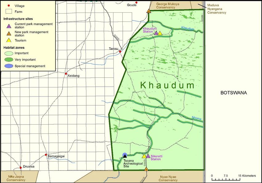
Foreword
National parks are a vital tool for conserving Namibia’s essential biodiversity. By
managing parks, their irreplaceable assets and unlimited potential will be conserved
for future generations. In addition, every year Namibia’s National Parks draw large
numbers of tourists to Namibia, generating employment and stimulating
development nationwide. National Parks also provide a unique opportunity to benefit
local communities through rural development while providing research, education
and recreation opportunities.
Wilderness is the Khaudum National Park’s comparative advantage. The park,
situated in north eastern Namibia bordering Botswana, has less than 3000 visitors
annually and there are few tracks through the deep Kalahari sand. More elephants
than people frequent the park. It is a refuge for African wild dog and roan antelope.
Lion, cheetah and leopard are also found in the park.
This management plan sets out the objectives and guidelines for the management
and development of the Khaudum National Park. As such, it represents the policies
and intentions of the Ministry of Environment and Tourism (MET) on how the park
should be managed.
Park neighbours, traditional authorities, line Ministries, Regional Councils,
conservancies, private sector, tourists, contractors, organisations, institutions,
parastatals, researchers, professional hunters, and any entity or individual dealing
with the park, in any way, must ensure that any actions and decisions relating to this
park are in accordance with the park management plan. In addition, specific rules
and regulations in accordance with the applicable legislation will apply.
Shorter-term operational plans or work plans will also be developed in accordance
with the activities provided in the park management plan. These will identify specific
or annual prioritised actions, which need to be performed to address the priorities
specified in the park management plan.
The park management plan must be viewed as valuable and central document by all
management and policy level staff involved with a specific park. They should be
familiar with its contents, and should make use of it to familiarise new staff with the
aims, objectives, management principles and strategies for the park.
It is every staff member’s (involved with Khaudum National Park) responsibility to
ensure that the park management plan is implemented accordingly.

Uahekua Herunga, MP
MINISTER
Preface
In a briefing paper presented to the Namibian Cabinet in 1999, the North East Parks
were identified as development engines for the region, due to their natural assets
and the resulting tourism potential. While this management plan applies specifically
to Khaudum National Park, it takes particular account of the Park’s position within a
wide, regional network of conservation areas: conservancies, community forests
and conservation zones in neighbouring countries.
The management plan for Khaudum National Park was derived from several
workshops involving the management of the MET, local communities and other
stakeholders. The plan has been designed and structured to be priority focused and
action oriented, to facilitate implementation and the achievement of outputs and
outcomes.
It gives a brief background to the Park, including its purpose and objectives, and
placing it in a regional setting, before focusing on park management aspects.
Chapter 2 focuses on the management of natural resources in the Park while
Chapter 3 addresses aspects of regional conservation, park neighbours and
resident relations. The zonation of the Park is detailed in Chapter 4. The
management of prospecting and mining, and tourism development are covered in
Chapters 5 and 6, respectively. Detailed management considerations for
infrastructure are included in Chapter 7, while the last chapter covers aspects of
administration and management.
The plan is designed around a uniform structure for easy reference and use and
should be used in conjunction with park legislation and regulation. The plan
therefore articulates, at the strategic level, the ‘What’ must be done; with a brief
description of the ‘Why’ these actions must be implemented to attain the specified
objectives. It is imperative to operationalize these actions in a clear and detailed
annual work plan.
The Ministry of Environment and Tourism would like to thank all its staff members,
partners and stakeholders who participated in developing this management plan,
specifically the Caprivi Parks Consultants, a partnership of Namibian firms
appointed to help implement the Bwabwata Mudumu Mamili Parks Project which is
co-funded by the Government of the Republic of Namibia and the German
Government through KfW, who facilitated the compilation of the plan.

Simeon N. Negumbo
Permanent Secretary
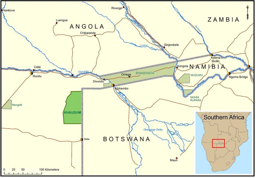
Table of Contents
Abbreviations and Acronyms                                               7
1    Introduction                                                        8
     1.1    Overview of Khaudum National Park                            8
     1.2    Purpose                                                     11
     1.3    Objectives                                                  11
2    Management of natural resources                                    13
     2.1    Habitats and special sites                                  14
     2.2    Fire                                                        15
     2.3    Rehabilitation                                              16
     2.4    Wildlife population management and introductions            16
     2.5    Artificial water points and management                      18
     2.6    Domestic animal management                                  19
     2.7    Fencing                                                     19
     2.8    Human wildlife conflict management                          20
     2.9    Diseases and parasites                                      20
     2.10 Alien species                                                 21
     2.11 Law enforcement and crime prevention                          21
     2.12 Environmental impact assessment and management                22
     2.13 Consumptive resource utilisation                              23
     2.14 Research                                                      24
     2.15 Monitoring                                                    25
3    Regional conservation and park neighbour relations                 26
     3.1    Transfrontier conservation                                  26
     3.2    Regional land use planning and landscape level management   27
     3.3    Park neighbours                                             27
     3.4    Private partnerships                                        28
     3.5    Environmental education                                     29
4    Zonation                                                           30
5    Prospecting and mining                                             34
6    Tourism development and management                                 35
7    Infrastructure                                                     38
     7.1    Access and roads                                            39
     7.2    Buildings                                                   40
     7.3    Tourism infrastructure                                      41
     7.4    Airstrips and aircraft                                      41
     7.5    Waste management                                            42
     7.6    Human safety                                                43
     7.7    Fencing                                                     43
     7.8    Water supply                                                44
8    Administration and management                                      45

Glossary                                                                48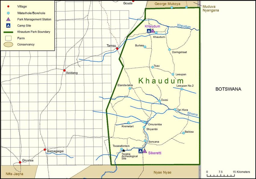
Appendices
Appendix 1: Biophysical zonation of the North-East Parks and its application to the
            Khaudum National Park
Appendix 2: Application of tourism zonation for Khaudum National Park
Appendix 3: Species of special concern in Khaudum National Park
Appendix 4: Tourism concession recommendations for Khaudum National Park
Appendix 5: Artificial water point assessment report
Abbreviations and Acronyms BMN Bwabwata, Mudumu and Nkasa Rupara National Parks CBPP Contagious Bovine Pleuropneumonia DNRM Directorate of Natural Resource Management EIA Environmental Impact Assessment EMP Environmental Management Plan EPL Exclusive Prospecting Licence HWC Human-wildlife conflict IBMS Incident Book Monitoring System IUCN International Union for the Conservation of Nature KAZA TFCA Kavango Zambezi Transfrontier Conservation Area MET Ministry of Environment and Tourism NBRI National Botanical Research Institute NGO Non-government Organisation SSCFU Small-scale commercial farming units TB Pulmonary tuberculosis
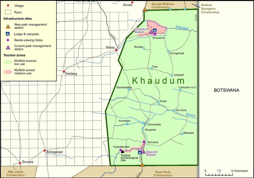
Chapter 1
Introduction
Located in the Kavango Region, Khaudum National Park occupies some 385,000
ha of Kalahari Sandveld in the north-eastern part of Namibia.
As elaborated below, the reserve protects northern Kalahari Sandveld and provides
refuge for threatened species such as roan, tsessebe, African wild dog as well as
other species, including elephant.

Map 1: Khaudum National Park is located in the Kavango Region and is one of the
North-East Parks.

1.1 Overview of Khaudum National Park
Khaudum National Park is bordered by Botswana to the east, where a double
electrified game fence provides a barrier to free and large scale animal movement,
although periodic breaks and subsequent movements of species such as elephant
do occur. The purpose of these fences is to control the movement of cattle and
people, and thus curtail the spread of diseases such as Foot-and-Mouth Disease
and Contagious Bovine Pleuropneumonia (CBPP or ‘lung sickness’). There are no
indications of livestock presence within the Park. The presence of the poisonous
plant Dichapetalum cymosum, which is prevalent on the dystrophic (nutrient poor)
northern sandy soils of the Burkea africana-Eragrostis pallens veld, is a major
deterrent to cattle.
Map 2: Khaudum National Park covers 385,000 ha and shares its eastern border
with Botswana.

Conservancies to the north (George Mukoya and Muduva Nyangana), and south
(Nyae Nyae and N#a-jaqna) are not fenced, and there is evidence of seasonal
movement of elephant in particular, from Nyae Nyae into Khaudum during the wet
season, and back to Nyae Nyae during the dry season. This emphasizes the
importance of Khaudum National Park as a core conservation area from where
animals may populate the neighbouring conservancies, thereby contributing to their
economic success.
Historically, movement of wildlife out of the Park, from east to west along omiramba
during the wet season, is reported. The establishment of small-scale farms along
the western boundary will of course impact on these movements and potentially
increase human-wildlife conflict.
Khaudum is one of the few refuges in which rare and endangered species such as
roan antelope, tsessebe and African wild dog can roam freely, underlining the Park’s
important conservation status. In addition, Khaudum is the only Park in Namibia that
protects large expanses of the Northern Kalahari Sandveld forest and woodland
biome, and one of the few areas where species such as oryx and roan overlap.
In the northern section of Khaudum, deep sandy dystrophic soils predominate, with
broadleaf savanna woodland interspersed with omiramba. To the south, soils on
quartzite with calcrete predominate, giving rise to a relatively more mixed Acacia-
broadleaf vegetation, interspersed with ‘fingers’ of teak woodland (Baikea plurijuga)
on deeper sands.
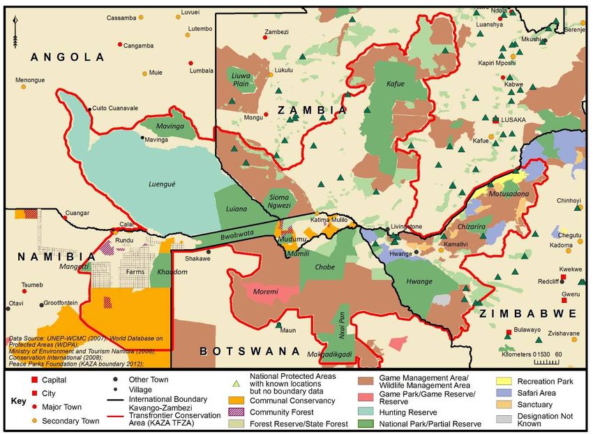
An agreement between the Administration for Kavango and the Department of
Agriculture and Nature Conservation to proclaim Mahango, Khaudum and Popa
Falls as State protected areas was signed in December 1982. Khaudum was
eventually proclaimed as a game reserve in 1989. Following independence, the
Ministry of Environment and Tourism (MET) immediately initiated a socio-ecological
survey that included the North-East Parks and surrounding areas. One outcome of
the survey led to the introduction of legislation in 1996 to allow residents on
communal land to form conservancies, thus allowing them the same rights over
wildlife and tourism as people owning private land. At the time of writing, there are
three conservancies registered that directly border Khaudum National Park: George
Mukoya and Muduva Nyangana to the north and Nyae Nyae to the south. All three
conservancies are also in the process of being gazetted as community forests.
In 1998, also following recommendations of the socio-ecological survey, a vision for
the North-East Parks was developed. This document created a joint vision among
stakeholders for conservation, tourism development, equity and the creation of
partnerships. Cabinet approved this vision in 1999. It was further decided that
neighbouring communities or those living in Bwabwata, Nkasa Rupara, Mudumu
and Khaudum were to be given conditional tourism rights in these parks; and the
Khaudum Game Park was renamed as Khaudum National Park.
North-East Parks are also important corridors for animal movement within the
greater region in Namibia and surrounding countries. It is in this context that the
North-East Parks are the geographic heart of the Kavango Zambezi Transfrontier
Conservation Area (KAZA TFCA). This massive area includes numerous proclaimed
national parks, game reserves, community conservation areas, forest reserves, and
iconic tourism destinations such as the Victoria Falls and the Okavango Delta. The
KAZA TFCA aims to broaden the protected areas network, thus increasing
biodiversity, expanding historical game migration and seasonal dispersal routes and
drawing more tourists to the area. In a place where local people often bear the costs
of living with wildlife, KAZA TFCA aims to make the protection of wildlife and wild
places more economically attractive to rural communities. Khaudum National Park
forms part of a western corridor, linking the Okavango Delta through northern links
with Bwabwata National Park (Mahango Core Area), and to the south east, through
the south-eastern corner and adjacent Nyae Nyae conservancy.
Map 3: The Kavango Zambezi Transfrontier Conservation Area (KAZA TFCA), a
five-country initiative involving Angola, Botswana, Namibia, Zambia and Zimbabwe,
encompassing an area of about 44,000,000 ha.

1.2 Purpose
This management plan describes the objectives, principles and strategies for the
management of Khaudum National Park so that all interventions can be planned,
focussed and co-ordinated according to agreed principles.
As an official document issued by the MET, the management plan is secondly a
statement of commitment that binds its staff to manage Khaudum National Park
according to provisions of the plan. Senior public servants of the MET are ultimately
accountable for implementation of the plan. Timelines for activities are included and
it is incumbent on MET management to agree on responsibilities for ensuring that
approved activities are timely addressed.
Thirdly, the plan obliges the wide variety of people and organisations (private sector
contractors, public service agencies, neighbours, tourists, etc) associated with
Khaudum National Park to ensure that their activities are congruent with provisions
of the plan.
Finally, implementation of the principles provided in this plan will reduce the need for
reactive, unplanned responses to unexpected events. Indeed, the management plan
should provide guidance over the next five years, and may only be changed with
the approval of senior management in the MET. In line with MET’s management
plan guidelines, this plan should be reviewed every five years, and amended as
objectives are met and new activities identified.
1.3 Objectives
1. To protect and maintain biodiversity - this captures all the management
   strategies directly related to the MET’s first core function of protecting and
   maintaining biodiversity. This specifically includes the protection of indigenous
   species, red data species, diversity of habitats and natural ecological processes,
   law enforcement, monitoring and research as well as rehabilitation of human-
   degraded habitats.
2. To maximise regional economic development, based on the principle of
   sustainable utilisation - this captures all the management strategies directly
   related to the MET’s second core function of maximising the sustainable
   economic benefit from biodiversity. This includes all aspects of tourism
   management and direct consumptive use of resources by local people. The aim
   is to support the MET’s strategic theme of rural development by utilising the
   basic resource of biodiversity.
3. To develop, implement and maintain effective and efficient systems,
   infrastructure and equipment that can support core functions - this
   captures all management strategies related to the non-human resources that
   the Park Warden can use in his management activities (infrastructure,
   equipment and the management system itself), as well as an outreach
   programme.
4. To develop, implement and maintain an efficient and sensitive human
   resources management programme - this captures all management
   strategies related to the Park’s human resources. This is the main theme
   through which health, education and gender issues can be mainstreamed into
   park activities.
5. To develop, implement and maintain regional conservation synergy
   through effective interaction with all park neighbours - this captures all
   management strategies related to liaison with park neighbours, including local
   communities, conservancies, other ministries, regional development planning
   institutions (government and non-governmental organisations) and processes,
   regional and local business and neighbouring countries (in particular Botswana).
   The latter is specifically included with reference to the KAZA TFCA initiative.
6. To develop, implement and maintain an efficient and functioning
   management system - this captures all management strategies related to the
   design, review, revision and implementation of the Park’s operational plans
   (annual work plan, monthly work plans, development plans, and financial
   planning systems). It also includes the monitoring of effectiveness of planning
   systems, in terms of both the biodiversity resource and the achievement of
   annual targets.
Chapter 2
Management of natural resources
Khaudum National Park is relatively flat to slightly undulating in parts, and crossed
in an east-west direction by two major omiramba – the Khaudum/Cwiba Omuramba
in the north and the Nhoma Omuramba in the south. There are numerous smaller
omiramba and pans scattered throughout the Park. Few if any hold water through
the dry season unless artificially supplemented. There are 14 boreholes in the Park
(refer to Map 2).
The Park is broadly divisible into two major vegetation zones based on the
underlying soils and geology. The north is largely composed of Burkea africana-
Eragrostis pallens savanna woodlands of variable density on deep Kalahari sand,
while the south is predominantly shrubland on soils derived from the Nosib group
quartzites with calcrete. The dunes have been degraded over geological time in
some areas and are only recognisable from the vegetation.
Temporary wetland development over deep Kalahari sands is usually limited to
interdune areas where drainage is impeded by clays or calcretes. These wetlands
are often localised and small, within depressions and omirambi. There are peat fires
in the Khaudum/Cwiba Omuramba, which have apparently been burning for
decades.

2.1 Habitats and special sites
Vegetation within the Park will be managed to achieve the overall objective of
maintaining, as far as is practicable, viable ecosystems that form part of the larger
Kalahari Sandveld woodland system. Essential ecological processes, such as fire,
will be managed to obtain the best outcomes for biodiversity in general. Sensitivity,
scarcity and threats are not static, and can be expected to change as different
pressures or forces are brought to bear on the Park and its surrounding areas.
Objective
To actively maintain all habitats in the Park, with special emphasis on omiramba and
surrounds, and to minimise the negative impact of fire on woodlands and optimise
its use as a management tool.
Strategies and Principles
Three categories – of high, medium and lesser significance – are recognised for
park habitats. A habitat’s significance may be adjusted as conditions change, and
additional habitats may be added. Khaudum does not contain rivers, swamps or
extensive floodplains. The omiramba and associated grasslands, the seeps and
seasonal pans are critical areas within the Khaudum context, especially for roan and
tsessebe. The deciduous woodlands similarly provide grazing and grazing reserves,
as well as corridors for movement between the preferred omiramba grasslands.
Therefore two categories have been identified in Khaudum National Park, these
habitats and their status are (also see Chapter 4):
Very important: All omiramba and immediate surrounds, seasonal pans and natural
seeps.
Important: Deciduous woodlands, including Burkea africana savanna, Baikea
plurijuga savanna, Terminalia sericea woodland, Acacia spp thickets and
shrublands.
In addition, cultural, historical or archaeological sites, such as Tsoanafontein,
require appropriate protection and conservation.
Tools to manage habitats include the use of fire, adjusting wildlife numbers and
species ratios, changing the distribution and temporal management of man-made
water points, protecting specific high-value areas against damage by elephants, and
rehabilitating degraded areas.
Activities
a) Key habitats, special sites and invasive alien species should be clearly identified
   and mapped, and management guidelines developed for each (year 1, ongoing
   until completed).
b) The status and threats to habitats and special sites must be reviewed every five
   years and new management strategies developed to counter any significant
   threats. Should this be necessary, this plan must be systematically revised to
   reflect changes.
c) Threats posed by aliens must continually be assessed and addressed (year 1
   and then annually).
d) An active, adaptive fire management programme (see below) must be used to
   achieve specific stated habitat objectives (e.g. to maintain suitable habitat,
   including dry season ‘green bite’, for rare species like roan and tsessebe) (year 1
   and then ongoing according to the fire management strategy).

2.2 Fire
Fire has, and will continue to play an important role within the Park. Fire is deemed
crucial as a management tool to achieve other objectives. These include the
reduction of fuel loads to minimise destructive run-away wildfires as well as the
crucial provision of dry season ‘green bite’, in the proximity of available water, for
species such as roan and tsessebe.
Objective
To pro-actively use fire as a management tool to maintain habitats in the Park,
including those for important species such as roan and tsessebe; as well as to
reduce risks of runaway destructive wildfires.
Strategies and Principles
a) An adaptive fire management strategy, which harmonises with the Integrated
   Fire Management Strategy for Protected Areas, must be developed. Since
   different habitats may require different fire regimes, this should include:
             -   the spatial designation of the habitats on maps;
             -   the purpose of fire management for each area;
             -   an outline of the specified fire regime, which should include burning
                 frequency, the percentage of area to be burnt in a season or burning
                 cycle, the type of burn, and the season of burn.
b) The fire management strategy will guide the development of a three-year burning
plan. The plan must be revised late in the wet season of each year to take into
account:
- the extent and severity of the previous seasons’ fires;
- the current standing biomass (fuel loads) in different areas of the Park;
- the need to protect life and property;
- the availability of forage and refuge for wildlife, especially for
‘Important Species’; tourism requirements and logistical considerations.
c) Management should strive to prevent the occurrence of extensive wildfires that
burn more than 35% of a contiguous area in a season (with this target being
regularly reviewed in the context of fire monitoring data). Appropriate pro-active
fire management strategies must be developed to reduce extensive burns. The
strategies are to:
- take account of past woodland losses due to killing of mature trees
and lack of recruitment and regeneration, and address these in the
future;
- institute preventive measures such as fire breaks near the Park
boundaries and to protect property;
- ensure the reduction of fuel loads to minimise the severity of fires;
- use early burning as a strategy to reduce the danger of late season
hot wildfires;
- take note of the impact of fires on tourism;
d) Proactive fire management must be used to protect infrastructure.
e) Park staff will work, as far as possible, with neighbours (communities, other
departments and institutions, other countries) to manage burning with specific
reference to the Park’s position in the proposed KAZA TFCA.
f) Fires will only be controlled or suppressed under the following conditions:
- when they pose a threat to life or property;
- once the specific goals of set fires have been met;
- if they are likely to burn excessive areas or threaten the survival of
certain species and/or habitats.
Activities
a) Develop a fire management strategy that addresses the specific requirements of
each habitat or sub-habitat in year one.
b) Develop a three-year burning plan in year one which will be revised at the end of
each summer growing season, based on the results of the previous season’s fire
patterns, and on monitoring data.
c) Establish a burning ‘team’ to evaluate past burns and future possible burning
areas every year.
d) Continually improve the knowledge and understanding of fire in these
ecosystems every year.e) In collaboration with the Bwabwata Ecological Institute, make use of remote sensing data, as well as field surveys, to detect and map fires in year one and regularly at a period advised by the responsible MET officer. f) Establish fire emergency procedures in year one. g) Establish forums with local communities and other agencies to manage burning in year one. 2.3 Rehabilitation Human activities have left a currently negative, albeit localised, impact on parts of Khaudum National Park, requiring appropriate rehabilitation. These include degraded moats around some borehole/pump structures, as well as decrepit tourism and management structures at Khaudum and Sikeretti camps and administrative centres. Some hides at waterholes are also rundown, aesthetically unattractive and need either demolition or rehabilitation after a thorough assessment of their usefulness or otherwise. Objective To rehabilitate degradation caused by humans especially where it impacts on ecosystem functions and processes as well as aesthetic considerations, and where rehabilitation is practicable and appropriate. Strategies and Principles The visual or other impacts of degraded areas must be assessed against the costs and benefits of rehabilitation. Activities a) Identify areas where degraded, rundown or unnecessary structures occur, including hides, moats protecting boreholes and old tourism and staff structures every year. b) Make use of old structures or material for building and/or recycling where practical, cost-effective and feasible in years two and three. c) Explore the possibility of allowing tourism operators to rehabilitate areas allocated to them within concessions (once concessions are awarded). 2.4 Wildlife population management and introductions Appropriate and strategic management of wildlife is required for a number of reasons. First, several animal species in Khaudum National Park have been identified as priorities for management within Namibia. Second, some species of large mammals have become uncommon or rare in the Park. Third, the North-East Parks, including Khaudum, form part of important corridors for animal movement across the greater region of Namibia and surrounding countries. Fourth, there is a need to increase wildlife numbers to develop the tourism potential of Khaudum. Finally, some species cause human-wildlife conflicts, which increase tensions between neighbours and the MET. A variety of interventions may be employed to manage wildlife. These include the provision and innovative management of artificial water sources; creation of wildlife
corridors and grazing areas around the Park that can act as buffer zones;
monitoring of populations; patrolling; fencing; park zonation; and control of livestock
and wildlife/livestock diseases.
Objectives
To sustainably manage, and reintroduce where necessary, the full complement of
species that occurred recently, with special emphasis on priority species (listed in
Appendix 3).
Strategies and Principles
a) Identify (through appropriate research), remove or minimise factors that lead to
      local species extinctions or significant declines in their numbers.
b) Where practical, manage wildlife populations to:
               -   maintain the ecological integrity and sense of place of Khaudum
                   National Park;
               -   develop and maintain tourism attractions of high quality;
               -   support management practises that improve habitat for fauna both
                   inside and outside the Park, particularly the conservancies to north
                   and south;
               -   reduce or eliminate the impacts of alien species, with an emphasis on
                   species that pose an immediate and high threat, such as domestic
                   cats that may cross-breed with wild species.
c) Manage key species, which have been prioritised by the MET (such as elephant,
      roan, tsessebe, wild dogs) to achieve conservation targets for those species.
                                                                                                      1
d) Ensure that only appropriate species, and no ‘genetically exotic species’ , are
      introduced and that re-introductions are cost-effective.
e) Permit the migration and inter-seasonal movement of fauna where possible, and
      investigate anthropogenic factors that may limit movements (such as
      inappropriate land-use practices on the Park boundaries), with a view to existing
      with them.
f)     Ensure that introductions inside the Park and into neighbouring conservancies
      are harmonised.
g) All introductions are to be approved in advance by MET.
Activities
a) Implement and maintain the Incident Book Monitoring System (IBMS) to monitor
      populations of key species each year.
b) Investigate, and if necessary develop strategies to meet population performance
      targets for important species which are threatened or rare in year two and three.
c) Update (if necessary) in collaboration with the Directorate of Natural Resource
      Management and implement existing species management plans (e.g. elephant,
      roan/ tsessebe) in each year.


1
    Only animals of the same genetic origin as those already present in and around Khaudum National Park.
d) Develop effective anti-poaching programmes to eliminate or reduce the impact of
poaching, as a major potential threat to the economic value of the Park and
surrounding areas in year one.
e) Take the following steps before species are re-introduced or populations
bolstered through introductions:
- explore what management actions may be taken to create conditions
for the species to increase or re-populate the areas;
- undertake appropriate research to understand why populations are low
or locally extinct, and to determine whether causal factors can be
eliminated;
- develop re-introduction plans to ensure that pre-release and post-
release management strategies and resources are in place (prior to
any introductions).
2.5 Artificial water points and management
The provision and management of artificial water is a complex matter, particularly in
an area that is devoid of surface water for much of the year, but hosts certain animal
species, which have adapted to these conditions. While the provision of artificial
water points may increase populations of these species, it may affect other species
adversely. These impacts are often poorly understood and any intervention to
supply water must therefore always be carefully considered.
Objectives
To maintain existing water points in good working condition, and accessible to all
species. Additional artificial water points for wildlife within the Park are discouraged.
However, subject to risk analysis, water may be strategically located (a) to increase
the numbers of vulnerable, rare or threatened species, or (b) for economic reasons,
such as tourism in the Park and hunting in neighbouring conservancies, provided
this does not adversely impact on priority habitats or important species.
Strategies and Principles
a) To maintain all artificial water installations in good working order throughout the
year, with special emphasis on the hot dry periods.
b) The provision of any additional artificial water points must demonstrably
contribute to one or more of the goals of the above objective. The goal(s) must
always be clearly stated.
c) The effects of water points must be reviewed regularly in the light of objectives.
d) Totalbenefits (environmental and economic) must outweigh the likely
management and environmental costs.
e) In natural ecosystems water may be a highly variable resource; provision of
artificial water should thus, as far as possible, mimic natural variability over time
and space.
f) For the placement of artificial water points, the following should be considered:
- the preferable location of water points near existing natural pans and
omiramba to supplement ephemeral supplies, bearing in mind whereadequate groundwater supplies occur (see Artificial Water Point
Assessment in Appendix 5);
- the possible location of water points in conservancies to encourage
dispersal to these areas where wildlife can contribute to sustainable
uses such as trophy hunting.
g) Where artificial water points are used for tourism, conservation objectives will
remain as the highest priority; as a result such water points may be
decommissioned or left dry to promote conservation or if serious negative
environmental impacts occur.
Activities
a) Conduct risk analyses for any proposed new artificial water points as needed.
b) Evaluate access to current water points for all wildlife species, and if necessary,
design and implement suitable waterhole structures for different wildlife species
in year two and three.
c) Establish a baseline monitoring system to assess negative impacts on vegetation
and key animal species; particular attention must be paid to roan, and tsessebe
and other priority species in year one and annually thereafter.
d) Develop and maintain a register of all borehole data (such as depth, delivery,
infrastructure specifications) in year one and annually thereafter.
e) Develop a water-point monitoring system for the availability of water for all
artificial water points in year one.
f) Investigate the possible value of developing a water-point rotation strategy to
encourage wildlife movement in year two and three.
g) Liaise with other ministries to ensure any water provision in the area does not
conflict with objectives of this management plan (ongoing).
2.6 Domestic animal management
While domestic animals are important resources for some neighbouring
communities, animals must be managed to contain associated risks. For example,
contact with certain wildlife species can result in the spread of disease and human-
wildlife conflict, and habitats may be degraded by concentrated grazing and
browsing of livestock entering the Park.
Objective
To ensure exclusion of domestic animals, which pose or are exposed to animal
health and other risks.
Strategies and Principles
a) Management of domestic animals will be done collaboratively between MET,
local neighbours (conservancies and community forests) and other ministries
and agencies (such as Ministry of Lands and Resettlement, Ministry of
Agriculture Water & Forestry and NGOs).Activities a) In collaboration with relevant stakeholders, develop and enforce a livestock management strategy aimed at reducing human-wildlife conflict, preventing the spread of disease, and domestic animals from straying into the Park in year two then ongoing. b) Implement the National Policy on Human-Wildlife Conflict Management and ensure that neighbouring communities are aware of the requirements of the policy (ongoing). c) On an ongoing basis, assess the need, desirability and impacts of a western boundary fence as livestock numbers increase on the small scale farms on the western boundary in year one and annually. 2.7 Fencing Khaudum National Park is an important link for wildlife movement between Namibia, northern Botswana and southern Angola. However fences and increased human settlement have reduced this function, but the Park still provides a ‘sink’ for animals, especially elephants, moving from Botswana and dispersing further westward along omiramba. While fences can disrupt wildlife movements, they may contribute to effective management if the barriers are properly located, designed, erected and maintained. Fences may therefore be provided in strategic locations to achieve specific goals, but always with due regard to animal movement. Objective Fencing is to be discouraged but may be strategically used to (a) significantly reduce livestock and/or wildlife diseases, (b) reduce human-wildlife conflict, (c) demarcate national borders, and (d) increase cross-border disease control. Strategies and Principles a) The objectives of each fence must always be clearly stated, and feasibility studies undertaken to ensure that the aim will be achieved. b) Environmental assessments including risk analysis must be undertaken for any new fencing projects. c) Planning and implementation of any new fences or fence upgrades should always be done in consultation with the relevant stakeholders. Activities a) In co-ordination with the Directorate of Veterinary Services and Directorate of Natural Resource Management, contribute to disease control and other livestock/ wildlife interactions (ongoing). b) MET should map and maintain a register of all fences around the Park. Registers should include the type of fence, reason for establishment, condition and any impacts in year two and three.
2.8 Human wildlife conflict management
The unrestricted movement of wildlife between the Park and surrounding areas
leads to serious conflicts between humans and wildlife (HWC).
The small scale commercial farming units (SSCFUs) on the western boundary are
likely to result in increased incidences of HWC, as domestic stock and water points
provide attraction for predators and elephants in particular. In addition to damage
suffered by people, conflicts pose a significant threat to the viability of conservation
in and around the Park. Ways of mitigating the impacts of conflicts therefore need to
be found and managed.
Objective
To actively engage with communities and other relevant stakeholders to ensure
there are effective and responsive mechanisms in place to minimise conflicts.
Strategies and Principles
a) Manage HWC in line with the National Policy on Human Wildlife Conflict
   Management (2009).
b) Due to the mobility of wildlife, HWC should be managed at a local level and
   collaboratively between park managers, conservancies, and other relevant
   stakeholders.
c) Within the parameters allowed by legislation, greater decision-making authority
   should be given to local MET officials to manage problem animals.
d) In line with national policy on HWC management, plans and operating protocols
   should be developed collaboratively with neighbours.
Activities
a) In line with the National Policy on Human Wildlife Conflict Management (2009),
   develop and refine HWC management plans and procedures in collaboration
   with local communities, and ensure these are widely communicated to
   community members and relevant staff within MET in year two.
b) Investigate the possibility of creating a buffer zone between the Park and its
   neighbours and engage relevant stakeholders and authorities in this regard in
   year one and two.

2.9 Diseases and parasites
Many diseases and parasites are a threat to people and the economy of the region.
Some, such as malaria, are detrimental to humans while others are exclusively
animal diseases. Management of these diseases and their control have wide
ramifications, including environmental impacts.
Objective
To work with other relevant public service agencies to find solutions to the
management and control of notifiable and contagious human, livestock and wildlife
diseases.
Strategies and Principles
a) Wildlife introduced from other areas should not be infected with exotic diseases
   such as TB or with diseases that are already endemic to the area.
b) National veterinary acts and regulations should be adhered to.
c) Fences may only be used to control the risk of diseases when this is absolutely
   essential and following environmental assessment and feasibility studies.
Activities
a) Work   with other government agencies and local institutions such as
   conservancies to find environmentally acceptable solutions to the control of
   human, livestock and wildlife diseases and ensure that appropriate technologies
   and methods are applied (ongoing).

2.10 Alien species
Alien species are species that were introduced since historical times by humans into
habitats far outside their native range. These species have the potential to cause
significant ecological damage, often out-competing native species or changing the
environment to such an extent that entire indigenous ecosystems may become
threatened. Not all alien species are invasive, however, the chances of an invasive
species being introduced increases rapidly with the number of alien introductions. It
is therefore widely accepted that alien species should be controlled, or better still,
removed from areas where biodiversity conservation is the main objective.
Although Khaudum National Park is relatively free of alien species, continuous
vigilance is required to maintain this status.
Objective
To identify and control invasive species.
Strategies and Principles
a) Staff must be vigilant and report any occurrences of alien species immediately.
b) Alien species control must be planned and implemented in a systematic manner
   with clear targets, and the results must be monitored regularly.
Activities
a) Clearly identify and map incidences if invasive alien species, and develop
   management guidelines for each in year one and annually.
b) Manage and where practical eradicate invasive alien species (ongoing).
c) Continually assess and address threats posed by all alien species (ongoing).

2.11 Law enforcement and crime prevention
The illegal use of natural resources generally poses a threat to conservation and
remains a major management issue for MET. As illegal activities are generally
conducted in unsustainable ways, they further undermine the ability of the
environment to support growing human populations and plant and animal life.
Poaching of plants and animals, indiscriminate cutting down of trees and
unsustainable land uses are a few examples. In addition to these illegal activities,
people may also enter the Park to intimidate, harm and rob tourists.
To ensure that the Park is able to offer a product of high quality to tourists, it is
important to undertake law enforcement at the appropriate scale and apply a zero
tolerance approach on the illegal use of resources and inappropriate use of the Park
in general.
Objective
To control and limit the illegal use of wildlife and natural resources within Khaudum
National Park and, through all efforts possible, to ensure the safety and security of
tourists.
Strategies and Principles
a) Develop a practical, harmonised approach to the implementation of law
   enforcement within the context of this management plan, relevant legislation and
   regulations, by working closely with law enforcement agencies and neighbouring
   communities.
b) Plan, develop and implement an efficient and effective tourism management and
   access control system.
c) Ensure security and anti-poaching patrols and surveillance are conducted for all
   natural resources (including harvesting and theft) in partnership              with
   neighbouring communities, at regular but unpredictable intervals.
d) Develop a system of rewards (financial or otherwise) for the reporting of illegal
   activities and let it be widely known in the area.
e) Ensure that MET staff members are adequately trained in law enforcement to
   ensure that they operate within relevant policies and laws and to preserve and
   collect evidence so that arrests result in convictions.
Activities
a) Develop a collaborative law enforcement working group with neighbouring
   conservancies and other relevant stakeholders in year one.
b) Develop (with relevant partners) a practical plan for implementing law
   enforcement in the context of this management plan and relevant legislation.
   This plan will include but not be limited to patrolling (foot, vehicle), roadblocks,
   informer network, and communication with a particular focus on identified
   poaching problem areas in year one but reviewed annually.
c) Regularly review and inspect poaching problem areas (ongoing).
d) Develop (with relevant partners) an effective tourism management and access
   control system with particular attention to holiday seasons in year one but
   reviewed annually.
e) Develop good relations with all tourism operators and, with their help, develop a
   systematic reporting process whereby they can report any illegal activities that
   they observe during their normal activities (ongoing).
f) Disseminate information on law enforcement approaches and reward schemes
   (ongoing).
g) Carry out regular patrols to ensure a high level of presence and visibility
   (ongoing).
2.12 Environmental impact assessment and management
Activities associated with both conservation management and tourism may degrade
or change vegetation, disturb or alter animal populations, destroy archaeological
artefacts and sites, and affect cultural habits and social systems. The assessment
and subsequent management of these potential impacts are key principles in
ensuring that the utilisation of Park resources is done sustainably.
Objective
To prevent and mitigate negative effects and enhance positive effects of
conservation management and tourism activities on the environment, by conducting
a due environmental impact assessment and management process.
Strategies and Principles
a) Environmental Impact Assessments (EIAs) are to follow relevant legal and policy
   guidelines as provided by Namibia’s Environmental Management Act of 2007.
b) Some conservation management activities undertaken in the normal course of
   biodiversity protection are intended to affect habitats or populations of species.
   Such types of conservation management actions (e.g. burning regimes, elephant
   management and the provision of water) are not subject to a formal
   environmental assessment process, but decisions should always be taken within
   the framework of adaptive management and be fully informed of potential
   outcomes and risks.
c) Guidelines provided for each zone in the Park are the key management tool to
   guide the environmental assessment and management process during planning
   and implementation of tourism activities and the development of any
   infrastructure to be used for Park management.
d) Environmental management should always include a careful evaluation of
   potential impacts and of ways to prevent, avoid or mitigate these impacts to a
   point where the environmental cost is commensurate with the overall purpose of
   the Park as well as with any legal requirements.
Activities
a) Ensure that zonation plans and guidelines are followed in the planning and
   implementation of all activities and developments (ongoing).
b) Ensure Environmental Management Plans (EMPs) are prepared and included in
   the tourism concession agreements and work contracts (as concessions are
   identified and tenders requested).

2.13 Consumptive resource utilisation
It is widely agreed that while protected areas should serve the purpose of
conservation, natural resources within those areas may be used on a sustainable
basis for economic and social gain. In the case of Khaudum National Park, based
on historic agreements, this applies to reed and thatching grass harvesting in
particular. The consumptive use of these resources in the Park will therefore occur
within the guidelines directly and indirectly stated in this management plan.
Objective
To facilitate and manage the sustainable use of reeds and thatching grass and any
other resources that may be determined by MET from time to time.
Strategies and Principles
a) All resource utilisation in the Park will be done in accordance with the National
   Policy on Utilisation of Game in Protected Areas and other State Land, and
   should economically and ecologically sustainable.
b) All plans for resource utilisation must be approved by MET.
c) Park neighbours will be allowed to utilise natural resources within the Park in
   terms of written agreements with conservancies or community forests.
d) All harvesting must be cost effective, and should take into account the full costs
   of managing the resource, including the costs of control, monitoring and effects
   on the environment.
e) The Park may be used as a source of wildlife for introduction to other areas.
f) While trophy hunting can provide important economic benefits, it may conflict
   with the priorities of the Park. In deciding on any possible future hunting zones
   and wildlife quotas for removal, the following need to be considered:
             -   the purpose of the Park;
             -   economic returns from trophy hunting compared to other uses;
             -   the practicalities of implementing and controlling trophy hunting;
             -   the implications of trophy hunting for other tourism operations or
                 visitors; and
             -   other potential negative impacts of trophy hunting activities, such as
                 the increase in aggressiveness of elephants.
Activities
a) Before any harvesting is undertaken, assess the resource to ensure that
   ecological objectives are not violated (prior to any harvesting).
b) Establish procedures and protocols for how, where and when the harvesting will
   be conducted and managed (on a case-by case basis).

2.14 Research
Objective
To base Park management on pertinent available information and data to support
an adaptive management approach and to create a research-friendly environment
that encourages relevant and focussed research.
Strategies and Principles
a) A coordinated approach to research will be created between park staff and other
   research agents, such as the MET Directorate responsible for research and the
   other relevant research bodies.
b) A supportive environment will be created for national and visiting scientists,
   including the facilitation of research permits, with preferential support given to
applied research projects in support of priority Park information or management
needs.
c) A prioritised and open-ended list of key research topics will be developed for the
Park and disseminated to appropriate research institutions.
d) Research will be supported, primarily through collaboration, and will focus on the
following:
- regional game movements, paying particular attention to the
appropriate ecological spatial scale and context;
- predator-prey relations;
- elephant impacts, including competition for space, water etc with other
species;
- improving management effectiveness, especially that which pertains to
human-wildlife conflict, fire, community wildlife-and-tourism-related
impacts;
- the socio-economic impact of the Park.
e) Appropriate mechanisms will be developed to ensure that optimum feedback and
other values from national and visiting researchers are obtained to inform Park
management decisions on all levels.
Activities
a) Identify gaps in knowledge relating to management and where appropriate,
through collaboration, find solutions to improve the understanding of the natural
system and the socio-economic benefits from the Park (ongoing).
b) Develop an open-ended list of priority research topics based on information
needs for the management of Khaudum National Park in year one and as need
arises.
c) Ensure research outputs and findings are made available to MET park staff and
integrated with monitoring data in the Park to inform park management decisions
on all levels (ongoing).
2.15 Monitoring
Regular monitoring and data collection will feed into adaptive management and
decision-making and inform all relevant management decisions. Modern methods
such as the Incident Book Monitoring System (IBMS) will be used to collect data on
the variables to be monitored.
Monitoring on an operational level is not limited to the natural resource base, but
also includes management efficiency.
Objective
To monitor carefully selected indicators of ecosystem integrity (in general) and
wildlife population dynamics to allow for timely and judicious adaptive management;
to monitor the efficiency of management systems and procedures.Strategies and Principles a) Natural resource monitoring will focus on key indicator processes, impacts, habitats and species, with an emphasis on ensuring regular data collection at appropriate intervals, cost efficiency and sustainability. b) Monitoring will also assess the effectiveness of management using standardised park inspection sheets and performance assessment. c) Monitoring systems shall apply approved tools already being widely used, e.g. IBMS, and shall also continue with systems already established and running within the Park. d) Monitoring systems will be balanced to ensure that the entire range of critical information needs is covered. e) Information will be made widely and freely available, in accessible format to all stakeholders to feed into adaptive management decision-making. Activities a) Develop an appropriate monitoring framework to include the monitoring requirements of the Park and incorporate ongoing monitoring initiatives and where appropriate, adapt other national systems such as the IBMS, with appropriate training for staff and other implementing partners, and ensure alignment with the KAZA TFCA monitoring system in year one. b) Ensure that relevant monitoring and research outcomes are shared with Park staff for adaptive management purposes, and distributed to stakeholders as appropriate (ongoing). c) Conduct annual game counts (annually). Chapter 3 Regional conservation and park neighbour relations The Khaudum National Park is a key ‘core conservation area’ within a larger regional context. The Park forms an important source of wildlife for conservancies to the north and south. Clearly relationships between parks and neighbouring communities are more harmonious if they also derive benefits from conservation. It is therefore in everyone’s interests to promote conservation activities, compatible land use practices, and management and development initiatives to the benefit of all collaborating partners throughout the broader area around the Park. This should be achieved through effective and collaborative integrated park management, monitoring and development with local and international neighbours. Good working relations must be pursued with all neighbours to achieve regionally integrated conservation. Collaboration and integration will occur at three levels: internationally through the KAZA TFCA initiative, locally through liaison and collaborative management with communities and public service agencies, and finally with the private sector. However, agricultural developments around the Park present challenges for the future. As currently planned, the small-scale commercial farming units (SSCFUs) to the west of the Park are a cause for concern due to the potential increase in conflict with wildlife. In light of this, extraction of groundwater will increase, thus potentially
affecting water availability in the Park. The proximity of numerous fenced farms to
the western boundary of the Park will to a large extent “block” free wildlife
movement, which would impact the viability of KAZA TFCA in this area.
Furthermore, there are additional agricultural projects planned in Botswana to the
east of the Park, with potentially similar HWC and KAZA TFCA implications as
mentioned above.

3.1      Transfrontier conservation
As described above, the North-East Parks including Khaudum National Park form a
critical component of the KAZA TFCA shared by Angola, Botswana, Namibia,
Zambia and Zimbabwe.
Objective
To contribute to the viability of, and to be managed within the context of, a regionally
integrated conservation area that encompasses nearby North-East Parks and
conservancies, as well as neighbouring Botswana.
Strategies and Principles
a) Where appropriate and to the extent possible, management of the Park should
      harmonise with management approaches used for other regional conservation
      areas in Namibia and neighbouring countries.
b) KAZA TFCA institutions will be used for purposes of collaboration and dialogue
      with conservation managers in Angola, Botswana, Zambia and Zimbabwe.
c) The integrity of the Namibian natural resources will not be compromised by
      activities or requirements of neighbouring countries.
Activities
a) Collaborate at the appropriate level with and through KAZA TFCA structures and
      other inter-governmental cross-border structures to ensure that the objectives of
      this plan are aligned with the plans and objectives of other conservation areas in
      Namibia and in neighbouring countries (ongoing).
b) Encourage and support knowledge and information exchange programmes
      between conservation managers in Namibia and neighbouring countries
      (ongoing).
c) Develop and conduct collaborative management activities with neighbouring
      countries (ongoing).

3.2 Regional land use planning and landscape level management
A number of ministries are responsible for various planning programmes within and
around the Park. It is important that key provisions of this management plan and
other MET plans be accommodated within these planning initiatives. For example,
the likely impacts on the Park of increased groundwater extraction, fencing and
increased human and livestock presence along the western boundary warrant a co-
ordinated regional planning approach
Objective To engage with relevant Ministries and other authorities and stakeholders involved in regional land use planning, to ensure that requirements for the management of the Park are incorporated into regional land-use plans where appropriate. Strategies and Principles a) MET should cooperate with relevant authorities in the regional planning process to ensure that the conservation of biodiversity is recognised as a vital use of land and a component of the regional landscape. b) Land-use planning outside the Park should, wherever appropriate, be aligned and fully integrated with zoning plans for the Park and conservancies, as well as agreed KAZA TFCA plans. c) MET management must keep abreast of all regional government initiatives, and ensure that Park plans are brought to the attention of relevant authorities. Activities a) Ensure that the key elements of this management plan are accommodated in all regional planning (ongoing). b) Ensure that regional authorities are fully aware of the negative impacts that inappropriate planning will have on conservation and its ability to contribute to the national conservation objectives and regional economy (ongoing). c) Pro-actively embark on planning at the local and regional level, including the possibility of buffer areas around the Park, to mitigate conflicts and maximise synergies between land uses in year two and three. 3.3 Park neighbours Khaudum National Park has and can continue to contribute the wellbeing of neighbouring communities through the establishment of viable businesses based on natural resources. Communities around the Park therefore have much to gain, especially if it is managed as a core area from which economic benefits extend to beyond the Park’s borders. However, such a scenario is only possible if relations between park management and communities are constructive and based on an integrated approach. The interactions must be based on trust so that the wider landscape of the Park and community areas can be managed and developed for mutual benefit. The need to encourage, support and use established collaborative management structures is critical for engagement between the Park and its neighbours. Simplicity, operational efficiency and the achievement of common goals are vital to the success of these structures. Following this, the obligations of park managers and community members should also guide the process. Objective To establish and maintain Park neighbour relations between Park staff and existing collaborative management structures, including the conservancies and community forests north and south of the Park and the SSCFU farmers, for the mutual benefit of communities and the objectives of the Park.
You can also read