MARINE AND COASTAL ENVIRONMENTS (MC) - SCIENTIFIC ASSESSMENTS
←
→
Page content transcription
If your browser does not render page correctly, please read the page content below
MARINE AND COASTAL ENVIRONMENTS (MC)
SCIENTIFIC ASSESSMENTS Part III
Traditional Owners
  The Commissioner for Environmental Sustainability
  proudly acknowledges Victoria’s Aboriginal community
  and their rich culture and pays respect to their Elders
  past and present.

  We acknowledge Aboriginal people as Australia’s first
  peoples and as the Traditional Owners and custodians
  of the land and water on which we rely. We recognise and
  value the ongoing contribution of Aboriginal people and
  communities to Victorian life, and how this enriches us.

  We embrace the spirit of reconciliation, working towards
  the equality of outcomes and ensuring an equal voice.

ISBN: 978-0-6485069-1-1
SCIENTIFIC ASSESSMENTS Part III Marine and Coastal Environments

Marine and Coastal                                     Background
Environments                                           Massive sand dunes bookend the Victorian
The information, data and indicators presented         coastline at its borders with South Australia and
in this chapter focus on the marine and coastal        New South Wales. Connecting Discovery Bay in
environments of Victoria. Although some of the         the west to the east’s Cape Howe Wilderness Zone
indicators build on the comprehensive assessment       are 2,500 km of rock stacks, granite islands, sheer
of marine science for Port Phillip Bay and Western     cliffs, intertidal platforms, dominant headlands,
Port that was presented in State of the Bays 2016,     extensive mudflats, fringing saltmarsh and
not all the science is repeated here, and the reader   mangroves, sandy beaches, large bays, coastal
should refer to that earlier work for a complete       lagoons and more than 100 estuaries.
presentation of the science.
                                                       Facing south, Victoria’s coastline looks out on the
In terms of the integration of this chapter with       cool temperate waters of the Southern Ocean,
the other chapters in SoE 2018, marine water           where 75% of red algae species, 85% of fish species
quality, estuarine health and marine biodiversity      and 95% of seagrass species are found nowhere
are all reported on here, but note two important       else, giving them local, national and international
exclusions:                                            significance.1 Beneath Victoria’s 10,000 km2 of
                                                       coastal waters are subtidal reefs, deep canyons,
1.   Only coastal Ramsar sites and wetlands
                                                       seagrass meadows, sponge gardens and sandy
     are presented in this chapter; refer to the
                                                       and muddy seabeds that support a rich marine life
     Biodiversity chapter for inland sites.
                                                       of more than 12,000 plant and animal species. 2
2.   Sea-level rise and associated impacts are
                                                       The Victorian Government and local governments
     reported on in the Climate Change Impacts
                                                       have worked to improve marine and coastal
     chapter.
                                                       planning, protection and management through
                                                       the following processes: legislation, regulation,
                                                       institutional policy-setting, strategic and statutory
                                                       planning, and the creation of conservation
                                                       reserves. Local communities have also engaged in
                                                       consultation, monitoring and habitat-restoration
                                                       works. But the pressures on coastal and marine
                                                       environments have continued to build, largely
                                                       driven by the resource-intensive demands of
                                                       population growth and climate change.

                                                       The success or otherwise of these responses
                                                       has in recent years been measured by State of
                                                       the Environment reports in 2008 and 2013, State
                                                       of Bays 2016 report, and the Gippsland Lakes
                                                       Condition Report 2018. This chapter builds on the
                                                       research and evaluation of these earlier reports
                                                       while also looking towards 2021 (when the first
                                                       of five-yearly State of the Marine and Coastal
                                                       Environment reports will be released) and 2030
                                                       (the time horizon of the United Nations Sustainable
                                                       Development Goals targets).

                                                       1.   Government of South Australia 2013, ‘State of the Environment Report
                                                            2013’, Adelaide, South Australia http://www.epa.sa.gov.au/soe_2013/
                                                            main/coast-1-why-is-it-important.html Accessed 4 December 2018.
                                                       2.   PV 2018, ‘Sea Search manual: A guide for community-based monitoring
                                                            of Victoria’s marine national parks and marine sanctuaries’, Melbourne,
                                                            Victoria.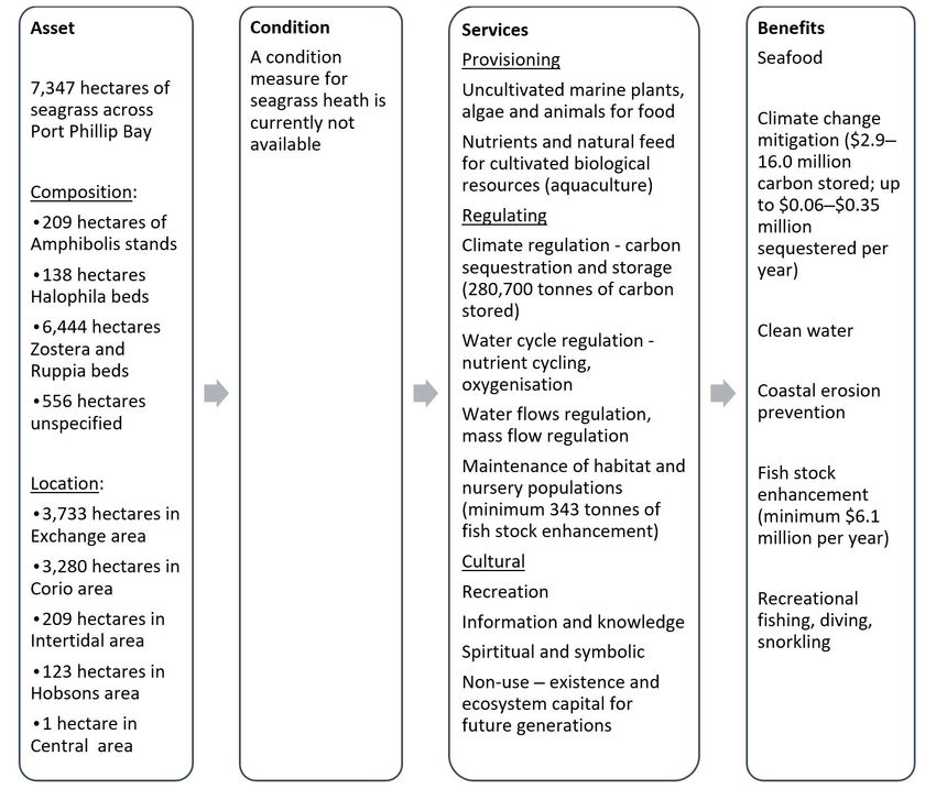
SCIENTIFIC ASSESSMENTS Part III Marine and Coastal Environments

Pressures on Marine and Coastal                                           Population growth and urbanisation

Environments                                                              The rate of population growth in Victoria’s coastal
                                                                          populations varies by region. In parts of the
A 2012 Ipsos poll for the Victorian Coastal Council                       south-west coast, populations are stable or in
showed that the top four marine and coastal issues                        decline. From 2011 to 2016, the Barwon Heads –
for Victorians were overfishing/illegal fishing,                          Ocean Grove population grew by more than 28%,
pollution, development and stormwater pollution.                          Torquay-Jan Juc, 27%, the Surf Coast and Bellarine
Compared to earlier polls, fewer respondents                              Peninsula, 18%, and the Bass Coast, 11%.4
believed the coast was well-managed and two-
thirds felt that the sea level was rising due to                          Most population growth is occurring on the
climate change, and this was causing erosion and                          Mornington and Bellarine peninsulas, driven by the
flooding. 3 This section reviews these and other                          expansion of Melbourne and Geelong and the ‘sea
pressures.                                                                change’ phenomenon. Towns within commuting
                                                                          distance of Melbourne and Geelong are expanding
                                                                          and becoming ‘dormitory suburbs’ or places to
                                                                          retire. In towns bordering the Gippsland Lakes,
                                                                          retirees are responsible for an annual growth rate
                                                                          of more than 2%. According to the 2012 Ipsos poll,
                                                                          growth like this will continue: 7% of respondents
                                                                          who lived more than 5 km from the coast said
                                                                          that they planned to move to the coast within five
                                                                          years. 5

                                                                          The Victorian Coastal Council describes the
                                                                          impacts of population growth:

                                                                                   ... biodiversity and habitat loss,
                                                                                   water degradation in coastal
                                                                                   waters, wetlands, lakes and rivers,
                                                                                   coastal habitat loss, damage to
                                                                                   wetlands, the introduction of pest
                                                                                   plants and animals, coastal erosion,
                                                                                   destruction of coastal ecosystems,
                                                                                   loss of cultural heritage, conversion
                                                                                   of productive agricultural land
                                                                                   and impacts on scenic coastal
                                                                                   landscapes, views and vistas.
                                                                                   Socially, it can lead to pressures on
                                                                                   the particular values and character
                                                                                   of coastal areas and settlements –
                                                                                   the very reason people choose to
                                                                                   move to or visit a place.6

                                                                          4.   ABS 2016, ‘Quick Stats 2016’, www.abs.gov.au/websitedbs/censushome.
                                                                               nsf/home/quickstats?opendocument&navpos=220/ Accessed 4
                                                                               December 2018.
                                                                          5.   Ipsos Consultants 2012, ‘Coastal and marine environment community
                                                                               attitudes and behaviour: wave four report’, prepared for Victorian
3.   Ipsos Consultants 2012, ‘Coastal and marine environment community         Coastal Council, Ipsos Consultants, Melbourne, p.4.
     attitudes and behaviour: wave four report’, prepared for Victorian   6.   Victorian Coastal Council 2017, ‘Population and growth’, http://vcc.
     Coastal Council, Ipsos Consultants, Melbourne, p.7.                       vic.gov.au/page/victorian-coastal-strategy/population-and-growth
                                                                               Accessed 4 December 2018.

Victorian State of the Environment 2018 Scientific Assessments (MC)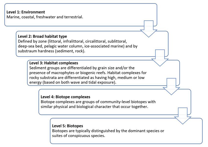
SCIENTIFIC ASSESSMENTS Part III Marine and Coastal Environments

Victoria’s coastline attracts significant numbers                              Habitat loss, fragmentation, degradation and
of tourists. Growing numbers of domestic and                                   disturbance
international visitors will place further stress
                                                                               Coastal and catchment development over the
on marine and coastal environments, building
                                                                               past two centuries has led to significant losses of
pressure on authorities to increase access with new
                                                                               coastal ecological vegetation classes (EVCs), with
roads, car parks and other visitor management
                                                                               some now endangered, vulnerable or depleted.
and attractions infrastructure. Visitor numbers in
                                                                               Coastal alkaline scrub has been reduced to 22% of
the four key coastal tourism regions of the Great
                                                                               its original cover on the Victorian Volcanic Plain,10
Ocean Road – Geelong and Bellarine Peninsula,
                                                                               31% on the Otway Plain and 56% on the Gippsland
Mornington Peninsula and Phillip Island7 –
                                                                               Plain. The Otway Plain has just 26% of its pre-1750s
increased substantially between 2013 and 2018.
                                                                               cover of coastal saltmarsh – Port Phillip Bay, only
Across the regions, all annual increases were as
                                                                               50%.11
follows: domestic daytrip visitors – between 2% and
7.2%; domestic overnight visitors – between 5.4%                               Migratory shorebirds, 35 species of which visit
and 8.5%; and international overnight visitors –                               Australia, have been severely affected by the
between 6% and 14%. 8 The Great Ocean Road had                                 loss of habitats along their international flyways,
the highest numbers of international visitors but                              particularly in the Yellow Sea. However, habitat
on Phillip Island and the Mornington Peninsula their                           loss has also occurred in Australia due to
numbers increased at a faster rate.                                            population growth, urbanisation and agricultural
                                                                               development. A 2015 Commonwealth report found
About 96% of Victoria’s coast is within public land
                                                                               that ‘estuaries and permanent wetlands of the
which abutts the high-water mark, although in
                                                                               coastal lowlands have experienced the most
many places it is a very narrow strip squeezed
                                                                               losses, especially in the southern parts of the
between rising seas and coastal development. The
                                                                               continent’.12 Other threats include: disturbance
Victorian Coastal Strategy 2014 acknowledged the
                                                                               from human activities; pollution; climate change;
coastal squeeze and that it could lead to a loss of
                                                                               invasive species; and harvesting of intertidal prey
public open space and community access:
                                                                               such as fish, urchins and sea weeds.
       If the coastal resources that
                                                                               Altered catchments can also lead to habitat
       maintain biological diversity such as
                                                                               degradation. The permanent opening of the
       saltmarshes and mangroves are to
                                                                               entrance to the Gippsland Lakes and catchment
       adapt to the impacts of sea-level rise
                                                                               dam construction have changed the site’s ecology
       and urban encroachment, outlays to
                                                                               by leading to increased salinity, reduced bank
       ‘buy-back’ land will be required. Also, in
                                                                               vegetation, mobilised bank sediments and reduced
       some circumstances, incorporation of
                                                                               light penetration, which has impacted seagrass. 13
       private land, to replace eroded public
       land, may be warranted to ensure
       community access to parts of the
       beach.9

7.   Although visitor numbers for the four selected regions include some
     visitation to areas away from the coast, for the other two regions with
     coastal boundaries, Melbourne and East Gippsland (includes mountain       10.   VEAC 2017, ‘Statewide assessment of public land: statewide EVCs
     areas), the coast may not be the main attractor. Data for these two             bioregional conservation status’, Melbourne, Victoria.
     regions have been excluded.                                               11.   Sinclair S, Boon P 2012, ‘Changes in the area of coastal marsh in
8.   DEDJTR (Tourism, Events and Visitor Economy Research Unit) 2018,                Victoria since the mid 19th century’, Cunninghamia 12 (2), pp. 153–176.
     ‘Regional tourism summaries for Great Ocean Road, Geelong and the         12.   Department of the Environment and Energy 2015, ‘Wildlife conservation
     Bellarine, Mornington Peninsula and Phillip Island for the year ending          plan for migratory shorebirds’, Canberra, Australian Capital Territory,
     March 2018’, Melbourne, Victoria, http://www.business.vic.gov.au/               p.14.
     tourism-industry-resources/research/regional-visitation Accessed 4        13.   Boon P, Cook P, Woodland R 2015, ‘The Gippsland Lakes: management
     December 2018.                                                                  challenges posed by long-term environmental change’, Marine and
9.   Victorian Coastal Council 2014, ‘Victorian coastal strategy’, Victorian         Freshwater Research 67 (6), pp.721-737 http://dx.doi.org/10.1071/MF14222
     Coastal Council, Melbourne, Victoria, p.24.                                     Accessed 4 December 2018.
SCIENTIFIC ASSESSMENTS Part III Marine and Coastal Environments

Marine and coastal wildlife can also suffer the                                  Water pollution
effects of human disturbance. Since 1980, Birdlife
                                                                                 Coastal urbanisation increases runoff, with Port
Australia volunteers have been conducting biennial
                                                                                 Phillip Bay each year receiving 540 billion litres of
counts for beach-nesting birds, including the
                                                                                 stormwater from more than 300 outfalls annually.15
hooded plover (Thinornis rubricollis rubricollis).
                                                                                 Stormwater can also contain hydrocarbons,
Its Victorian population was in serious decline but
                                                                                 pesticides, detergents, leaves, garden clippings,
the work of community volunteers and coastal
                                                                                 animal faeces and plastics, along with sewage
managers to protect breeding sites and improve
                                                                                 from leaking, broken or overflowing sewers. The
regulations, education and enforcement has seen
                                                                                 Yarra River, which flows through a large catchment
numbers slowly increase. However, its conservation
                                                                                 containing urban, industrial and agricultural uses,
status remains ‘vulnerable’ and threats such as
                                                                                 discharges 14,000 tonnes of sediment into the
coastal development, dogs, racehorses, vehicles,
                                                                                 bay annually, along with 650 tonnes of nutrients in
foxes, cats, sea-level rise and disturbance (dune
                                                                                 fertiliser, litter, heavy metals and bacteria.16
stabilisation, beach cleaning and seaweed
removal) are more generally on the increase.14                                   Beyond Port Phillip Bay, agricultural uses influence
                                                                                 water quality by causing nutrient and sediment
                                                                                 pollution that threatens estuaries and coastal
                                                                                 ecosystems. For example, in Corner Inlet there are
                                                                                 strong connections across catchment nutrients
                                                                                 and sediments, algal blooms, reduced light-
                                                                                 penetration and seagrass decline, which in turn
                                                                                 impacts the inlet’s commercial and recreational
                                                                                 fisheries. This was ‘the first strong evidence that
                                                                                 the activities in the catchment are contributing to
                                                                                 habitat loss and productivity costs to the fishery’.17

                                                                                 Eighteen ocean outfalls are found along the open
                                                                                 coast and are used to discharge sewage and
                                                                                 other waste that have undergone various levels
                                                                                 of treatment. Total annual discharges have been
                                                                                 estimated at 323 GL, with annual total nitrogen
                                                                                 loads of 3,811 tonnes and annual total phosphorous
                                                                                 loads of 2,784 tonnes.18

                                                                                 15.   EPA 2018, ‘Yarra and Bay’, www.yarraandbay.vic.gov.au/issues/
                                                                                       stormwater Accessed 4 December 2018.
                                                                                 16.   Ibid
                                                                                 17.   Ford J, Barclay K, Day R 2016, ‘Using local knowledge to understand
14.   Maguire G, Cullen M, Mead R 2014, ‘Managing the hooded plover in                 and manage ecosystem-related decline in fisheries productivity’,
      Victoria: a site by site assessment of threats and prioritisation of             Fisheries Research and Development Corporation Final Project Report,
      management investment on Parks Victoria managed land, Birdlife                   Melbourne, Victoria.
      Australia, Melbourne, Victoria https://parkweb.vic.gov.au/__data/assets/   18.   Clean Ocean Foundation 2018, ’The national outfall database
      pdf_file/0007/679030/managing-hooded-plover-birdlife-australia.pdf               community report’, Australia http://www.cleanocean.org/news/the-
      Accessed 4 December 2018.                                                        national-outfall-database-community-report Accessed 4 December
                                                                                       2018.

Victorian State of the Environment 2018 Scientific Assessments (MC)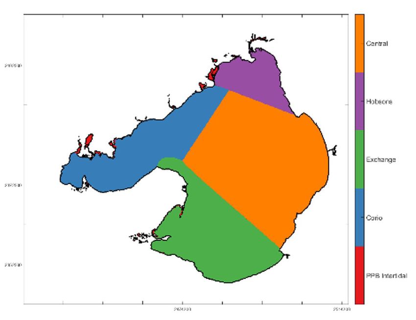
SCIENTIFIC ASSESSMENTS Part III Marine and Coastal Environments

Litter and marine debris                                                           In addition to being an eyesore on beaches and
                                                                                   waterways, litter and marine debris impact
Of the litter found on Port Phillip Bay beaches,
                                                                                   marine life. From 1997 to 2013, researchers found
95% washes off suburban streets and into the
                                                                                   359 entangled Australian fur seals (mainly
stormwater system.19 In 2012–13, litter control
                                                                                   juveniles and pups) at Seal Rocks at Phillip
programs removed 7,850 tonnes of litter and debris
                                                                                   Island, equivalent to 1% of the site’s population.
from waterways around Melbourne. 20 It has been
                                                                                   The researchers found that commercial fishing
estimated that 820 million pieces of litter are
                                                                                   operations were the main source of entanglement
discharged into Port Phillip Bay from the Yarra and
                                                                                   materials that included trawl nets, fishing line
Maribyrnong rivers each year. 21
                                                                                   and box straps. They determined that neither the
In 1991, an EPA Victoria tagged litter survey                                      decline in regional fishing intensity nor changing
estimated that 4–5 million pieces of plastic were                                  seal population size influenced the incidence of
entering Melbourne waterways annually, with most                                   entanglements. 25
washed up on beaches along Port Phillip Bay’s east
                                                                                   Fishing-related gear, balloons and plastic bags
coast. 22 For 12 months from March 2016, members
                                                                                   posed the greatest entanglement risk to marine
of BeachPatrol Australia, a Melbourne-based
                                                                                   fauna.26 Between 2010 and 2013, the Zoos Victoria
community group, conducted daily collections
                                                                                   Seal the Loop Program collected 21.7 km of fishing
of plastic along a 35-metre stretch of the Port
                                                                                   line in specially designed bins dotted along
Melbourne Beach. 23 By the survey’s end, 126,000
                                                                                   the Victorian coastline. 27 By 2013, the bins were
pieces of plastic litter had been collected, with
                                                                                   collecting 25 metres daily or 9 kilometres annually.
60% greater than 5 mm and 15% smaller than
                                                                                   Zoos Victoria and Phillip Island Nature Parks have
5 mm. A Port Phillip EcoCentre survey24 found
                                                                                   now launched the ‘When balloons fly, seabirds die’
that plastic film remnants were the second-most
                                                                                   campaign to educate the community about the
collected items, with plastic bags and wrappers
                                                                                   impact that balloons are having on marine life and
third. Nurdles (microplastics) were found on 12 of
                                                                                   to urge people to stop using balloons outdoors.
23 Port Phillip Bay beaches, although coordinators
                                                                                   A 2016 CSIRO paper noted that short-tailed
believed this number may have been understated
                                                                                   shearwaters on Australia’s east coast ingested
because volunteers were reluctant to invest time in
                                                                                   82% of all balloons recorded in a survey of marine
collecting such small items.
                                                                                   debris, possibly due to the balloons resembling the
                                                                                   birds’ main prey, the red arrow squid. 28

19.   CES 2016, ‘State of the Bays 2016’, Melbourne, Victoria.
20.   EPA 2018, ‘Litter’, Melbourne, Victoria https://yarraandbay.vic.gov.au/
      issues/litter Accessed 4 December 2018.
21.   Preiss B 2018, ‘A tale of two beaches, where volunteers fight to keep tide
      of city’s litter at bay’, The Age 7 July 2018.
22.   EPA 1993, ‘Backyard to bay: tagged litter report’, Melbourne, Victoria.      26.   Wilcox C, Mallos NJ, Leonard GH, Rodriguez A, Hardesty BD 2016, ‘Using
23.   Headifen R 2017, ‘A new survey method to determine plastic rubbish in              expert elicitation to estimate the impacts of plastic pollution on marine
      Port Phillip Bay’, BeachPatrol Australia.                                          wildlife’, Marine Policy 65, pp. 107-114.
24.   Port Phillip EcoCentre 2017, ‘Turn off the tap – catchment to bay litter     27.   Zoos Victoria 2013, ‘Seal the Loop 2012-2013 report’, Zoos Victoria,
      prevention and monitoring. Final report’, Port Phillip EcoCentre, St               Melbourne, Victoria.
      Kilda, Victoria.                                                             28.   Roman L, Schuyler QA, Hardesty BD, Townsend KA 2016, ‘Anthropogenic
25.   McIntosh RR, Kirkwood R, Sutherland DR, Dann P 2015, ‘Drivers and                  debris ingestion by avifauna in eastern Australia’, PLoS One, 11(8)
      annual estimates of marine wildlife entanglement rates: a long-term                pp. 1-14 https://journals.plos.org/plosone/article?id=10.1371/journal.
      case study with Australian fur seals,’ Marine Pollution Bulletin 101, pp.          pone.0158343 Accessed 4 December 2018.
      716-723.
SCIENTIFIC ASSESSMENTS Part III Marine and Coastal Environments

Climate Change                                                                    Closer to shore, the report found that, if the
                                                                                  effects of climate change are not halted, then the
The south-eastern waters of Australia are one
                                                                                  ecological functions of seagrasses and kelps will
of 10 global hotspots for rising sea-surface
                                                                                  be reduced, as will the protection they afford the
temperatures – the rate is almost four times faster
                                                                                  coast. Other changes that the report highlights
than the global average. 29 This has energised the
                                                                                  include, the loss of intertidal flats, platforms and
East Australian Current. It now reaches the coast of
                                                                                  beaches; closed estuaries; increased salinity and
Tasmania, 350 kilometres further south than where
                                                                                  flooding; and the prevalence of more tropical
it was 60 years ago, transporting warm waters and
                                                                                  species.
subtropical species such as cobia to Victoria.
                                                                                  Climate change will also impact food security and
In June 2018, the Victorian Coastal Council
                                                                                  human health, culture and livelihoods. A recent
released Victoria’s Coast and Marine Environments
                                                                                  ecological sensitivity assessment31 suggests that
under Projected Climate Change: Impacts,
                                                                                  blacklip abalone and southern rock lobster (the
Research Gaps and Priorities. The report stated
                                                                                  two mainstays of Victorian commercial fisheries)
that:
                                                                                  and black bream and King George whiting (very
      Victoria’s coastal regions are expected to                                  popular targets of recreational fishers) are the
      have a warmer climate year-round, more hot
                                                                                  most sensitive to climate change due to factors
      days and warm spells, harsher fire weather
      and longer fire seasons, less rainfall in winter                            such as altered habitats, increased water
      and spring, more frequent and more intense                                  temperatures, changing estuarine salinity and
      downpours, rising sea level, increased frequen-                             invasion by other species such as urchins. Southern
      cy and height of extreme sea-level events,                                  calamari and Australian salmon will also be
      increased wave height in winter, increased
                                                                                  affected. The same research also showed that the
      frequency of easterly winds, and warmer and
                                                                                  catches of many commercial species had declined
      more acidic oceans.30
                                                                                  and that other stressors such as overfishing,
                                                                                  invasive species, habitat loss, degradation of
The report notes that since 1880, Victoria’s sea                                  seagrass beds, and pollution in intertidal zones
level has risen 22.5 cm, while projecting rises in sea                            and juvenile nursery areas will exacerbate the
level of 8–20 cm by 2030 and 20–59 cm by 2070,                                    impacts and reduce the ability of species to adapt
and of sea-surface temperatures by 1.1–2.5°C by                                   to environmental change.
2070. In the offshore areas, the report suggests
                                                                                  The loss of giant kelp forests (Macrocystis pyrifera),
that rising water temperatures may decrease
                                                                                  once in a strip stretching along much of the
oxygen levels and reduce fisheries production.
                                                                                  Victorian coast, may in part be due to climate
Along with the economic effects of rising water
                                                                                  change and its associated rise in sea-surface
temperature, the report found that declining
                                                                                  temperatures. Small patches in the Otway, Central,
stocks of fish will also affect the island colonies of
                                                                                  Flinders and Twofold Shelf marine bioregions are
the Australian fur seal, little penguins and short-
                                                                                  all that remain, with water pollution, sedimentation
tailed shearwaters that rely on these stocks for
                                                                                  and storms other factors in the decline. 32
food. The report recommends regular monitoring
and reporting on the health of these colonies,
which would be an important indicator of ocean
health and climate change.

                                                                                  31.   Pecl GT, Ward TM, Doubleday ZA, Clarke S, Day J, Dixon C, Frusher S,
                                                                                        Gibbs P, Hobday AJ, Hutchinson N, Jennings S, Jones K, Li X, Spooner
                                                                                        D, Stoklosa R 2014, ‘Rapid assessment of fisheries species sensitivity
                                                                                        to climate change’, Climatic Change, 127(3-4), pp. 505–520 https://link.
                                                                                        springer.com/article/10.1007/s10584-014-1284-z Accessed 4 December
29.   Hobday A, Pecl G 2013, ‘Identification of global marine hotspots:                 2018.
      sentinels for change and vanguards for adaptation action’, Reviews in       32.   Department of the Environment and Energy 2009, ‘Advice to the
      Fish Biology and Fisheries, 24(2), pp. 415-425 https://link.springer.com/         Minister for Environment Protection, Heritage and the Arts from the
      article/10.1007/s11160-013-9326-6 Accessed 4 December 2018.                       Threatened Species Scientific Committee (the Committee) on an
30.   Victorian Coastal Council 2018, ‘Victoria’s coast and marine                      Amendment to the List of Threatened Ecological Communities under
      environments under projected climate change: impacts, research gaps               the Environment Protection and Biodiversity Conservation Act 1999’,
      and priorities’, Melbourne, Victoria.                                             Canberra, Australian Capital Territory.

Victorian State of the Environment 2018 Scientific Assessments (MC)
SCIENTIFIC ASSESSMENTS Part III Marine and Coastal Environments
Commercial and recreational fishing Assessing the broader impact of recreational
fishing in Victoria’s marine and coastal
Commercial fishers have been operating in
environments will require clarity on the number
Victorian waters since the 19th century, using
of recreational fishers in Victoria. Although only
nets, dredges, pots, hooks and hand collection
271,395 Victorian recreational fishing licences were
to harvest various marine species. In September
sold in 2016–1735 across the five categories, three
2017, there were 627 commercial licences across all
previous estimates have angler participation in
Victorian fisheries, targeting more than 40 finfish
the state at 549,000,36 721,00037 and 830,00038
and 30 species of molluscs, crustaceans, sharks
(adult residents), while the Victorian Government is
and rays.33
committed to increasing angler numbers to
Reduced fish populations, bycatch, entanglement 1 million through its Target One Million program.39
of wildlife in discarded fishing gear, vessel impacts
and changes to trophic structures are some of
the impacts of fishing on marine and coastal
environments. But the closure of most commercial
fishing in Port Phillip Bay and Western Port,
and lower catches elsewhere, has reduced the
industry’s pressure on stocks. However, this change
will limit future data on fish stocks and require an
expanded role for the monitoring of recreational
fishing.
Although there are more than 100 fish species
recorded in Victorian bays and inlets, recreational
fishers target about a dozen species, with snapper
(Pagrus auratus), King George whiting (Sillaginodes
punctata) and black bream (Acanthopagrus
butcheri) as the most prized. In 2000–01, 88% of
recreation catches came from Port Phillip Bay, and
those for snapper (211 tonnes) and King George
whiting (93 tonnes) were higher than the respective
commercial catches of 53 tonnes and 85 tonnes.34
35. VFA 2017, ‘Recreational fishing licence trust account 2016–17: a report to
each House of Parliament on the disbursement of recreational fishing
licence revenue’, Melbourne, Victoria.
36. Henry G, Lyle J 2003, ‘The national recreational and indigenous fishing
survey’, Project No. 1999/158. A report for the Australian Government
Department of Agriculture, Fisheries and Forestr. Canberra, Australian
Capital Territory.
37. VFA 2010, ‘Economic study of recreational fishing in Victoria – headline
results VRFish’, Melbourne, Victoria https://vfa.vic.gov.au/about/
33. VFA 2018, ‘Commercial fish production’, Melbourne, Victoria https://vfa. publications-and-resources/fisheries-reports/your-licence-fees-at-
vic.gov.au/commercial-fishing/commercial-fish-production Accessed 4 work-reports/2009-2010/economic-study-of-recreational-fishing-in-
December 2018. victoria-headline-results-vrfish Accessed 4 December 2018.
34. Ryan KL, Morison AK, Conron S 2009, ‘Evaluating methods of obtaining 38. Ernst and Young 2015, ‘Economic study of recreational fishing in
total recreational catch estimates for individual Victorian bay and Victoria’, a report for VFA Melbourne, Victoria.
inlet recreational fisheries’, Project No. 2003/047. A report for the 39. VFA 2018, ‘Target one million budget 2015–2019’, Melbourne, Victoria
Department of Primary Industries, Melbourne, Victoria, and Fisheries www.vfa.vic.gov.au/recreational-fishing/target-one-million/budget
Research and Development Corporation, Canberra, Australian Capital Accessed 4 December 2018.
Territory.SCIENTIFIC ASSESSMENTS Part III Marine and Coastal Environments
Ports, shipping and boating Invasive marine species
Port operations and shipping activity can impact More than 160 introduced marine species are
marine and coastal environments by causing now resident in Port Phillip Bay. Few impact
habitat damage and loss, increased turbidity local marine habitats and species. Those of
(from dredging), localised beach accretion and greatest concern are the northern Pacific
erosion, an increased risk of spills, air pollution and seastar (Asterias amurensis), the European fan
the introduction and spread of invasive marine worm (Sabella spallanzanii), the European green
species. Most of the invasive marine species in shore crab (Carcinus maenas), Japanese kelp
Port Phillip Bay arrived on the hulls or in the ballast (Undaria pinnatifida), the New Zealand screw
water of visiting ships, thousands of which visit the shell (Maoricolpus roseus) and the Pacific oyster
Port of Melbourne and Geelong Port each year. (Crassostrea gigas). The Asian date mussel
(Musculista senhousia), cordgrass (Spartina
Concerns like these, along with social, economic
anglica and Spartina x townsendii sp.), dead
and logistical considerations, saw the Victorian
man’s finger (Codium fragile ssp.) and red algae
Government seek advice from Infrastructure
(Grateloupia turuturu) are also of concern. Invasive
Victoria on the best location for a second container
marine species prey on – or outcompete – native
port – the Port of Melbourne is Australia’s largest
species for space, food and light.
and busiest and will likely outgrow its current
site. After extensive investigations, Infrastructure The eradication of invasive marine species is only
Victoria recommended Bay West in Port Phillip Bay, possible in very limited circumstances, and so the
rather than an expansion of the Port of Hastings, primary management focus is the prevention of
but indicated that operation of the new port would their introduction and spread. But the growing
not be required until 2055.40 Both locations are number of vessels operating in Victorian waters
Ramsar sites: port construction and its associated could undermine these efforts. For example,
infrastructure could impact on those wetland Japanese kelp was initially confined to northern
habitats. Port Phillip Bay, but its range has expanded to the
southern bay and also Apollo Bay Harbour (where
Recreational boating has become an increasingly
eradication has proved impossible). Japanese kelp
popular activity in Victoria. In 1962, an aerial survey
has recently been detected in Port Welshpool.
of Port Phillip Bay identified 1,208 recreational
boats, 41 but by 2015 there were 117,000 identified Invasive marine species in the Gippsland Lakes
in Port Phillip Bay and Western Port.42 Boating include the Pacific oyster (Crassotrea gigas), the
infrastructure such as breakwaters and car European green shore crab (Carcinus maenas),
parks can have localised impacts on coastal and the Asian date mussel (Musculista senhousia) and
marine environments. Sandringham Harbour’s the introduced green macroalgae, Codium fragile
breakwater has altered longshore drifting of sand (subsp. fragile).44 Also recorded were three species
and has led to significant coastal erosion. Harbour listed on the National Introduced Marine Pest
construction and expansion, along with associated Information System database: pleated sea squirt
road access, car parking, boat ramps and (Styela plicata), stalked ascidian (Styela clava) and
clubhouses, can reduce public open space. In the sea vase (Ciona intestinalis).
case of the proposed expansion of the Beaumaris
Motor Yacht Squadron, development would further
bury internationally significant land and marine
fossil beds already impacted by the existing
harbour infrastructure. 43
40. Infrastructure Victoria 2017, ‘Advice on securing Victoria’s port
capacity’, Melbourne, Victoria.
41. Lynch D 1966, ‘Port Phillip survey 1957–1963: the fisheries’, Memoirs
of the National Museum of Victoria 27, pp.16.
42. Boating Industry Association of Victoria 2015, ‘Boating industry
snapshot: drivers of growth in Victoria’, Melbourne, Victoria. 44. Hirst A, Bott N 2016, ‘Gippsland Lakes: existing threats and future
43. Smith B 2015, ‘World-class fossil site in Beaumaris threatened by monitoring’, Centre for Environmental Sustainability and Remediation,
marina expansion plans’, The Age 20 February 2015. RMIT, Melbourne, Victoria.
Victorian State of the Environment 2018 Scientific Assessments (MC)SCIENTIFIC ASSESSMENTS Part III Marine and Coastal Environments
Overabundant native animals Sydney’s gloomy octopus (Octopus tetricus) has
also extended its range on the East Australian
Increasing numbers of native sea urchins are
Current. Scientists were first alerted to its spread
causing the loss of marine habitats in Port Phillip
when citizen scientists reported sightings to the
Bay, Nooramunga and Beware Reef Marine
smart app, Redmap. Further research49 confirmed
Sanctuary.
the extended range of the octopus, which is a
Intact kelp beds can resist invasions by exotic predator of commercially targeted abalone and
marine plants, provide habitat for fish targeted rock lobster.
by recreational fishers, and be popular sites for
snorkelling and diving. But along the northern
shores of Port Phillip Bay, grazing by the purple
sea urchin (Heliocidaris erythrogramma) has led
to a 90% reduction in kelp in the bay’s marine
sanctuaries.45 In March 2018, Parks Victoria,
Deakin University and volunteer citizen scientists
carried out a cull of urchins in Jawbone and
Point Cooke Marine Sanctuaries, 46 with the aim of
keeping urchin numbers low for at least two years
to allow the kelp beds to recover. If successful,
the program will be expanded to other areas in
the bay. A current project by the University of
Melbourne, Deakin University and Parks Victoria
aims to manage urchin numbers and also trial kelp
restoration techniques outside protected areas.
In eastern Victoria, the small Beware Reef Marine
Sanctuary has also suffered an outbreak of
the black-spined sea urchin (Centrostephanus
rodgersii), a native of New South Wales carried
south at a rate of approximately 16 km’s each year
by the warming East Australian Current. 47 The
urchins graze on kelp and other algae, creating
areas of bare rock or urchin barrens. The Friends of
Beware Reef, and Parks Victoria, staff culled 2,500
urchins in early 2018, 48 and a draft native animal
impact management plan has now been prepared
by the agency.
45. Deakin University 2018, ‘Sea urchin cull in Port Phillip Bay to help
restore kelp forests’, media release, 15 March 2018, Deakin University,
Geelong.
46. Ibid
47. PV 2018, ‘Centrostepohanus rodgersii (black-spined sea urchin) impact
management plan’, Melbourne, Victoria. 49. Ramos JE, Pecl GT, Moltschaniwskyj NA, Semmens JM, Souza CA,
48. PV 2018, ‘United against the urchin front in East Gippsland’, media Strugnell JM 2018, ‘Population genetic signatures of a climate change
release, Melbourne, Victoria. driven marine range extension’, Scientific Reports, 8(9558), pp. 1-12.SCIENTIFIC ASSESSMENTS Part III Marine and Coastal Environments
Environmental weeds Oil and gas exploration and production
Environmental weeds are a major problem Oil and gas have been flowing from Bass Strait
for coastal habitats, especially near township since the 1960s, and in western Victoria from
gardens and farms, from where they often spread. the early 2000s. In May 2018 the Victorian
They compete with and prevent regeneration Government 51 released five new blocks for oil and
of indigenous native plants, alter coastscapes, gas exploration near existing gas production areas
increase bushfire risk and reduce available habitat in the Otway Basin off Victoria’s west coast, while
for wildlife. Some Australian native species, such new production wells in the Gippsland Basin are set
as acacia, eucalypt, melaleuca and allocasuarina, to produce gas in 2019.
have also become weeds, introduced through past
SoE 2013 noted that exploration and production of
dune stabilisation projects. 50
oil and gas can disturb seabed habitats. Seismic
testing may impact on cetaceans, and there is also
the risk of spills during operations. 52
In 2007, the CSIRO Wealth from Oceans flagship
program investigated the contribution that the
extraction of water and hydrocarbons from the
Gippsland Basin, along with the effects of extreme
wave conditions and sea-level rise, could make to
land subsidence and inundation along the Ninety-
mile Beach. CSIRO’s modelling predicted that by
2056, under a realistic scenario, the coast could
subside by 480 mm, whereas in a worst-case
scenario the figure was 1,208 mm. However, the
contribution of land subsidence to the predicted
levels of inundation ranged between 1% and 20%
– the larger figure for a small area with a low
combined risk of inundation. The CSIRO study
concluded that:
‘the simulations conducted predict that
subsidence due to fluid extraction, although
small in comparison, will exacerbate the risk
of inundation of the coastline due to extreme
storm tide and wave conditions with larger
parts of the Gippsland Coastline potentially
being affected. 53
51. The Hon Pallas T, MP 2018, ‘Offshore gas exploration to build future sup-
ply’, media release, Melbourne, Victoria.
52. CES 2013, ‘State of the environment report’, Melbourne, Victoria.
53. Freij-Ayoub R, Underschultz J, Li F, Trefry C, Hennig A, Otto C, McInnes
50. Mark Trengove Ecological Services 2013, ‘Barwon Coast vegetation K 2007, ‘Simulation of coastal subsidence and storm wave inundation
management plan final draft’, Geelong, Victoria prepared for risk in the Gippsland Basin’, CSIRO Petroleum Report 07-003, Bentley,
Barwon Coast Committee of Management. Western Australia.
Victorian State of the Environment 2018 Scientific Assessments (MC)SCIENTIFIC ASSESSMENTS Part III Marine and Coastal Environments
The Bass Strait oil and gas rigs are ageing and Droughts and Floods
will eventually have to be decommissioned. They
During the millennium drought (1996–2010) there
could be viewed as waste, dismantled and removed
were significant seagrass losses in Port Phillip
from the marine environment. Alternatively, they
Bay. 54 Land-based nitrogen inputs during the
could be left where they stand, continuing to act
millennium drought dropped by 64%; northern
as artificial reefs should evidence show that any
Pacific seastar (A. amurensis) arrived in the bay
environmental outcomes would be equal to or
in 1995 and its biomass rose to 56% of resident
better than if they were removed. But the disused
fish biomass in 2000; and in the centre of the
rigs could also attract invasive species, alter food
bay, fish biomass dropped 69%. 55 The reduced
webs and become navigational hazards.
productivity during the drought caused most of
the loss in fish biomass. However, A. amurensis was
implicated in a sharp decline of three species –
the eastern shovelnose stingaree (Trygonoptera
imitata), southern eagle ray (Myliobatis australis)
and globefish (Diodon nicthemerus) – due to
competition for food. The improvement plan for the
Western Treatment Plant also led to a reduction in
nutrient discharges. 56
The end of the millennium drought was followed by
major flooding across Victoria in 2010–11. Floods
send large volumes of sediments and nutrients into
estuaries, bays and offshore waters, significantly
affecting water quality and the health of receiving
waters.
54. Jenkins G, Keogh M, Ball D, Cook P, Ferguson A, Gay J, Hirst A, Lee
R, Longmore A, Macreadie P, Nayer S, Sherman C, Smith T, Ross J,
York P 2015, ‘Seagrass resilience in Port Phillip Bay: final report to
the Seagrass and Reefs Program for Port Phillip Bay, University of
Melbourne, Melbourne, Victoria http://www.pir.sa.gov.au/__data/assets/
pdf_file/0004/265585/Seagrass_Resilience_in_Port_Phillip_Bay.pdf
Accessed 4 December 2018.
55. Hirst A, Parry G 2016, ‘Decadal decline in demersal fish biomass
coincident with a prolonged drought and the introduction of an exotic
starfish’, Marine Ecology Progress Series, 544, pp.37-52.
56. Hirst AJ, Werner GF, Heislers S, White CA, Spooner D 2011, ‘Port Phillip
Bay Annual Trawl Sub-Program Milestone Report No. 4 (2011)’, Fisheries
Victoria Technical Report Series No. 139, Queenscliff, Victoria.SCIENTIFIC ASSESSMENTS Part III Marine and Coastal Environments
Marine and Coastal Policy, Data and monitoring challenges
Management and Monitoring Data and monitoring challenges include:
Challenges • expanding monitoring programs beyond
localised areas within Port Phillip Bay, Western
Port and the Gippsland Lakes
Policy and management challenges • broadening monitoring, from species to
ecosystems
Key future challenges for the marine and coastal
environment of Victoria include: • publicly releasing fisheries data on the impacts
of commercial and recreational fishing on
• ensuring effective community engagement in
bycatch, habitats, threatened species and
the ecologically sustainable management of
trophic structures
coastal and nearshore environments
• adapting monitoring programs to cover the
• implementing an effective and ecosystem-
loss of fisheries data from the closure of
based marine spatial planning framework to
commercial bays and estuaries to commercial
ensure equitable access to resources, while
fishing
ensuring the needs of the natural environment
are met • aligning the research priorities of agencies,
academic institutions and citizen scientists
• improving and simplifying coastal
with the needs of marine and coastal
management governance and oversight
management
• adapting to climate change and the impacts of
• developing historical ecological baselines
population growth
• monitoring the loss of coastal foreshore
• identifying and filling gaps in the marine and
reserves, and their EVCs, from erosion.
coastal conservation estate
• developing dispute resolution and arbitration
mechanisms that are specifically related to the
unique challenges in the marine and coastal
environment.
Victorian State of the Environment 2018 Scientific Assessments (MC)SCIENTIFIC ASSESSMENTS Part III Marine and Coastal Environments
The Act establishes statutory documents for
Current Victorian Government
planning and management of the marine and
Settings: Legislation, Policy, coastal environment at statewide, regional and
Programs local levels. This includes the preparation of a
Marine and Coastal Policy, and a Marine and
There have been many efforts by successive
Coastal Strategy, every five years by DELWP.
Victorian governments to improve marine and
These both require agreement across relevant
coastal planning, protection and management.
portfolios and are intended to help deal with key
This section briefly reviews the most recent.
challenges such as the impacts of climate change
Victoria’s new Marine and Coastal Act 2018 (the and population growth. The policy will include
Act) provides improved governance and oversight a marine spatial planning framework to help
of the marine and coastal environment and aims achieve integrated and coordinated planning and
to: management of the marine environment.
• establish an integrated and coordinated The new legislation requires that a State of the
whole-of-government approach to protect Marine and Coastal Environment report be
and manage Victoria’s marine and coastal prepared every five years by the Commissioner
environment for Environmental Sustainability, with the first due
in 2021. This report will monitor trends in a variety
• provide for integrated and coordinated policy,
of indicators to help measure the condition of the
planning, management, decision-making
marine and coastal environment and any changes.
and reporting across catchment, coastal and
This information will be used to better inform
marine areas
ecologically sustainable policy, planning and
• establish objectives and guiding principles decision-making.
for ecologically sustainable planning,
The Act introduces a new partnership approach for
management and decision-making.
planning for significant regional issues impacting
Recognising the need to plan for and manage the the marine and coastal environment. Regional
impacts of climate change is a significant addition and strategic partnerships (RASPs) will be formed
to coastal management in Victoria – as is the in certain areas, and they will produce tools to
acknowledgement of Traditional Owner groups’ address regional issues. Tools may include coastal
knowledge, rights and aspirations for land and sea hazard assessments, adaptation plans or other
country. regional plans. Importantly, these partnerships can
Under the Act, the number of advisory bodies formally include community and non-government
has been simplified by phasing out the regional members to boost public involvement.
coastal boards and Victorian Coastal Council and Environmental management plans will consider a
establishing the statewide advisory Marine and broad range of threats to the health of the marine
Coastal Council. The council will be responsible environment and aim to identify actions to address
for providing advice on the implementation of them. Catchment management authorities (CMAs)
the Act by agencies including the Department of are also now required to better plan for impacts
Environment, Land, Water and Planning (DELWP) on the marine and coastal environment through
and will be able to establish subcommittees – for Regional Catchment Strategies, and possibly
example, a science panel. RASPs.
Local-level planning will provide opportunities
for the community’s voice to be heard, and the
government anticipates a more streamlined
process for consents to use, develop or undertake
works on public land.SCIENTIFIC ASSESSMENTS Part III Marine and Coastal Environments
The new Act also aims to help address a key The policy also includes various environmental
technical gap by enabling organisations advising quality indicators, regional targets and priority
on coastal flooding (namely, coastal CMAs and areas, pollutant load reduction targets, and
Melbourne Water) to be consulted on matters rules and obligations. It also identifies high
relating to coastal erosion. conservation-value areas: high-value wetlands
(including wetlands of international importance
The Victorian Environmental Assessment Council
listed under Ramsar) and areas of significance for
(VEAC) is currently preparing a report on the
spawning, nursery, breeding, roosting and feeding
environmental, economic and social values of
of aquatic species and fauna.
Victoria’s marine environments which will inform
the Victorian Government’s preparation of the The vision for the Port Phillip Bay Environmental
statewide marine and coastal policy and marine Management Plan 2017–2027 57 is of a ‘healthy
spatial planning framework under the Marine and Port Phillip Bay that is valued and cared for by
Coastal Act 2018. VEAC is also investigating coastal all Victorians’. This 2017 plan replaced the 2001
reserves and will: plan and contains a broader set of priorities and
actions. The seven priorities are: connect and
• review the number and types (reservation
inspire, empower action, nutrients and pollutants,
status) of coastal reserves in Victoria
litter, pathogens (human health), habitats and
• identify reserves with high environmental, marine life, and marine biosecurity.
cultural heritage, social and economic values,
Victoria’s Climate Change Adaptation Plan
and identify values at risk from the impacts of
2017–202058 will build a detailed understanding
climate change
of the state’s exposure to climate change risks
• identify current and emerging uses of the and impacts, catalyse partnerships for integrated
coastal reserves and effective responses, and tackle immediate
• compile an inventory, including spatial priorities to reduce climate change risks. The plan
distribution, of values and uses of the coastal will work to ensure up-to-date information on
reserves. the coastal impacts of climate change, provide
guidance to managers on coastal adaptation,
A revised State Environment Protection Policy ensure sea-level-rise benchmarks are based on the
(Waters) commenced on 19 October 2018. best science, and provide resourcing through the
The purpose of this new policy is to provide a Climate-Ready Victorian Infrastructure – Critical
framework to protect and improve the quality of Coastal Protection Assets Program (2015–2019),
Victoria’s waters, while its objectives are to: which includes works to repair, renew and protect
• achieve the level of environmental quality cliffs, seawalls and groynes across the state. Local
required to support the beneficial uses of Coastal Hazard Assessments will also be used to
waters provide a more detailed analysis of climate change
risks and impacts.
• ensure that pollution to waters from both
diffuse and point sources is managed in an
integrated way to deliver the best outcome for
the community as a whole
• protect and improve environmental
quality through consistent, equitable and
proportionate regulatory decisions that
focus on outcomes and use the best available
information.
57. DELWP 2017, ‘Port Phillip Bay environmental management plan 2017-
2027’, Melbourne, Victoria.
58. DELWP 2017, ‘Victoria’s climate change adaptation plan 2017-2020’,
Melbourne, Victoria.
Victorian State of the Environment 2018 Scientific Assessments (MC)SCIENTIFIC ASSESSMENTS Part III Marine and Coastal Environments
The Invasive Plants and Animals Policy Framework The 2021 State of the Marine and Coastal
(IPAPF) presents the overarching Victorian Environment report will be able to evaluate the
Government approach to the management implementation of these polices, strategies and
of existing and potential invasive species. The plans.
IPAPF incorporates a biosecurity approach to
ensure that Victoria maintains a comprehensive
planning framework to guide the management
of invasive species. The Department of Economic
Development, Jobs, Transport and Resources is
developing a whole-of-government marine pest
module under the IPAPF to guide the management
of marine pests in the state. The scope of this
module will encompass exotic invasive marine
plants, marine algae, marine invertebrate animals
and marine fish.
The Victorian Waterway Management Strategy
addresses:
• the direct management of estuaries, for
example the use of risk-based assessments
(such as the Estuary Entrance Management
Support System) to inform artificial estuary
openings
• the management of upstream waters and
their catchments and associated inputs to
estuaries and coastal environments – through,
for example, riparian revegetation and stock
exclusion delivered through the Victorian
Waterway Management Program and
initiatives such as the Regional Riparian Action
Plan.
The Parks Victoria Act 1998 was reviewed and then
replaced with the Parks Victoria Act 2018. The new
Act establishes Parks Victoria as an independent
statutory authority, no longer acting as a service
agency to government and with management
powers granted to its board rather than delegated
by the secretary of DELWP. The Act aims to
strengthen Parks Victoria’s role of protecting,
conserving and enhancing Victoria’s parks and
waterways.
In 2017, the Victorian Government established
the Victorian Fisheries Authority to support the
development of recreational and commercial
fishing and aquaculture in Victoria, regulate
fisheries and provide advice to government on a
range of fisheries management opportunities.SCIENTIFIC ASSESSMENTS Part III Marine and Coastal Environments
In summary, marine and coastal data is limited in
Marine and Coastal
the following ways:
Environmental Indicators
• The focus of marine data collection has been
Overview of indicator status assessment on the 5% of coastal waters in marine national
This section of the chapter provides the status parks and sanctuaries, leaving 95% of coastal
assessments for 24 indicators that cover: coastal waters largely unmonitored.
wetlands and estuaries; intertidal and subtidal • Data is very often inadequate to determine
reefs; seabirds, shorebirds and waterbirds; status and trends for many indicators, with the
pressures on the marine and coastal environments; gap between monitoring periods too long (or
and conservation in protected areas. Assessments the research has not been repeated).
for some of the indicators in State of the Bays
• Comparisons are often between pre-1750s and
2016 report have been reproduced here, while the
current data with no recent data to establish
summaries that accompanied them have been
contemporary trends.
abridged. This is also the case for those indicators
applied to the Gippsland Lakes, with the status, • Data collected may not be meaningful or may
trends and summaries sourced from the Gippsland be insufficient for the indicators that are being
Lakes Condition Report 2018. assessed.
For the indicators added for SoE 2018, the • The analysis and public reporting on data
assessment of their status and trends has been collected are at times minimal, with data
hampered by a lack of available data. In most on websites sometimes requiring specific
cases the data has either been absent, out of browsers and/or login security details and/or
date or gathered over an insufficient time period. presented in file formats that are not directly
Without robust data it is not possible to determine useable by the community.
the status and trends for many of these indicators.
• Changing data collection methodologies and
Marine and coastal environments that aren’t terminologies make comparison over time and
part of Victoria’s marine conservation estate are between different databases difficult.
surveyed infrequently. Some areas have only been
• The coastal environment is often included
surveyed once, and in many instances, there is
in statewide analyses without separate or
no recent data. What monitoring that does occur
specific treatment.
is largely undertaken by academic institutions,
non-government organisations and volunteers, • Government agencies’ reliance on limited data
with public agencies constrained in their efforts collections, while universities, other research
by limited resources. The work of volunteer institutions and the community have much to
organisations – such as Birdlife Australia, The offer.
Nature Conservancy, the Victorian National Parks
The development of a Marine Knowledge
Association (ReefWatch and nature conservation
Framework, as recommended by the State of
reviews) and groups and individuals involved in
the Bays 2016 report, will extend to coastal
Sea Search, EstuaryWatch, Coastcare, Reef Life
environments and begin to address these issues.
Survey, Landcare and other programs – has been
pivotal in maintaining a degree of monitoring. This
voluntary effort requires ongoing support and
should be complemented by a significant increase
in government agency monitoring.
Victorian State of the Environment 2018 Scientific Assessments (MC)SCIENTIFIC ASSESSMENTS Part III Marine and Coastal Environments
Rises in sea level, and carbon dioxide, and air and
Coastal Wetlands and Estuaries
water temperatures and increased storm intensity,
There are at least 16 coastal wetland EVCs, of along with changing rainfall patterns and wave
which the most common and spatially extensive regimes, will impact on coastal wetlands already
are: mangrove shrubland (EVC 140), coastal affected by population growth and its associated
saltmarsh (EVC 9), estuarine wetland (EVC 10), coastal development, land reclamation and levee
brackish grassland (EVC 934), brackish wetland bank construction.
(EVC 656), seagrass meadows (EVC 845) and saline
This section reviews indicators for mangroves,
aquatic meadow (EVC 854). 59
saltmarsh, seagrass, seagrass-dependent fish and
The most recent inventory60 of coastal wetlands estuaries.
estimated there were 19,212 hectares of coastal
saltmarsh, 5,177 hectares of mangroves and
3,227 hectares of estuarine wetland along the
Victorian coastline. Of these, 218 hectares
of mangroves and 6,390 hectares of coastal
saltmarsh were on private land.
Six areas of coastal wetlands in Victoria have
been listed under the Ramsar Convention: Corner
Inlet (including Nooramunga) (67,186 hectares),
Edithvale–Seaford Wetlands (262 hectares),
Gippsland Lakes (60,015 hectares), Glenelg Estuary
and Discovery Bay (22,289 hectares), Port Phillip
Bay (Western Shoreline) and Bellarine Peninsula
(22,897 hectares), and Western Port (59,297
hectares).
There has been growing scientific interest in the
monitoring and assessment of estuary condition
in Victoria’s more than 100 estuaries since the
release of the National Land and Water Resources
Audit of 2002,61 and the subsequent development
of the Index of Estuarine Condition in Victoria,
due for release in 2020 and based on five themes:
physical form, hydrology, water quality, flora
and fauna. Even so, saline coastal wetlands and
estuaries remain very poorly studied habitats in
south-eastern Australia.62
59. DELWP 2016, ‘Climate change vulnerability and adaptive capacity of
coastal wetlands. Decision Support Framework – Volume Two’, Mel-
bourne, Victoria.
60. Boon PI, Allen R, Carr G, Frood D, Harty C, Mcmahon A, Mathews S,
Rosengren N, Sinclair S, White M, Yugovic J 2014, ‘Coastal wetlands of
Victoria, south-eastern Australia: providing the inventory and condition
information needed for their effective management and conservation’,
Aquatic Conservation Marine and Freshwater Ecosystems, 25(4), pp.
454–479.
61. National Land and Water Resources 2002, ‘Australian catchment river
and estuary assessment’, Canberra, Australian Capital Territory.
62. Sinclair S, Boon P 2012, ‘Changes in the area of coastal marsh in Victo-
ria since the mid 19th century’, Cunninghamia, 12 (2), pp. 153–176.
Victorian State of the Environment 2018 Scientific Assessments (MC)You can also read