Marine Monitoring Guidance - Prepared by: LGL Limited Environmental Research Associates and Environmental Protection Division, Ministry of ...
←
→
Page content transcription
If your browser does not render page correctly, please read the page content below
Marine Monitoring Guidance

                                    Prepared by:

                  LGL Limited Environmental Research Associates

                                        and

Environmental Protection Division, Ministry of Environment & Climate Change Strategy

                                  December 2019

                                                                                       1
Table of Contents
ACRONYMS................................................................................................................................................................4
GLOSSARY .................................................................................................................................................................4
1.0 INTRODUCTION .................................................................................................................................................6
1.1 BASELINE STUDY .................................................................................................................................................8
1.2 OPERATIONAL MONITORING PROGRAM ...............................................................................................................9
2.0 SITE CHARACTERIZATION & INFORMATION COMPILATION ......................................................... 10
2.1 OPEN AND EMBAYED MARINE WATERS ............................................................................................................ 11
2.2 WATER VALUES................................................................................................................................................. 11
2.3 CONCEPTUAL SITE MODEL ................................................................................................................................ 12
2.4 CURRENTS, TIDES, BATHYMETRY, FLUSHING RATES ........................................................................................ 13
2.5 RECEPTORS ........................................................................................................................................................ 13
2.6 CUMULATIVE EFFECTS ...................................................................................................................................... 14
3.0 IDENTIFYING CONTAMINANTS OF POTENTIAL CONCERN .............................................................. 14
3.1 EFFLUENT CHARACTERIZATION ......................................................................................................................... 14
3.2 MODELLING: PLUME MIXING AND DILUTION RATIOS ....................................................................................... 15
4.0 RISK CLASSIFICATION & SUPPORTING STUDIES ................................................................................. 15
4.1 BIOACCUMULATIVE & PERSISTENT SUBSTANCES .............................................................................................. 17
4.2 TOXICITY TESTING ............................................................................................................................................ 18
4.3 MICROBIOLOGICAL ............................................................................................................................................ 18
4.4 NUTRIENT ENRICHMENT .................................................................................................................................... 18
4.5 CONTAMINANTS OF EMERGING CONCERN ......................................................................................................... 19
4.6 CUMULATIVE EFFECTS ...................................................................................................................................... 19
4.7 SENSITIVE AREAS .............................................................................................................................................. 19
5.0 STUDY DESIGN ................................................................................................................................................. 20
5.2 SAMPLE SIZE...................................................................................................................................................... 20
5.3 QUALITY ASSURANCE & QUALITY CONTROL .................................................................................................... 20
5.3.1 Replicates .................................................................................................................................................. 21
5.4 BEFORE-AFTER-CONTROL-IMPACT (BACI) STUDY DESIGN.............................................................................. 21
5.5 MULTIPLE CONTROL/IMPACT (MCI) STUDY DESIGN ......................................................................................... 21
5.6 SIMPLE GRADIENT DESIGN ................................................................................................................................ 21
5.7 RADIAL GRADIENT DESIGN ............................................................................................................................... 21
5.8 MULTIPLE GRADIENT DESIGN ........................................................................................................................... 22
6.0 SITE SELECTION .............................................................................................................................................. 22
6.1 REFERENCE SITES .............................................................................................................................................. 22
6.2 EXPOSURE SITES ................................................................................................................................................ 23
6.2.1 End-of-Pipe ............................................................................................................................................... 23
6.2.2 Outfall Terminus ....................................................................................................................................... 23
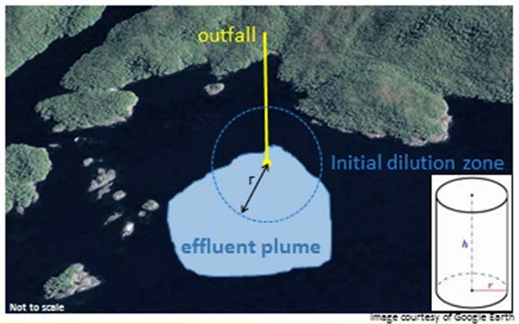
6.2.2 Initial Dilution Zone (IDZ)........................................................................................................................ 23
6.2.3 Far-Field ................................................................................................................................................... 24
6.3 AREAS OF SPECIAL CONCERN ............................................................................................................................ 24
6.4 ENVIRONMENTAL MONITORING SYSTEM (EMS) ............................................................................................... 25
7.0 WATER QUALITY MONITORING ................................................................................................................ 25
7.1 PARAMETERS ..................................................................................................................................................... 26
27.2 SAMPLING FREQUENCY ..................................................................................................................................... 26
7.3 SAMPLING METHODOLOGY AND EQUIPMENT .................................................................................................... 27
7.3.1 Quality Assurance & Quality Control ....................................................................................................... 28
8.0 SEDIMENT QUALITY MONITORING .......................................................................................................... 28
8.1 PARAMETERS ..................................................................................................................................................... 29
8.2 SAMPLING FREQUENCY ..................................................................................................................................... 29
8.3 SAMPLING METHODOLOGY AND EQUIPMENT .................................................................................................... 30
8.3.1 Quality Assurance & Quality Control ....................................................................................................... 31
9.0 BIOLOGICAL MONITORING ......................................................................................................................... 31
9.1 PARAMETERS ..................................................................................................................................................... 31
9.2 SAMPLING FREQUENCY ..................................................................................................................................... 32
9.3 SAMPLING METHODOLOGY AND EQUIPMENT .................................................................................................... 32
9.3.1 Benthic Invertebrate Community .............................................................................................................. 32
9.3.2 Benthic Invertebrate Tissue....................................................................................................................... 33
9.3.3 Bivalve Tissue & Health............................................................................................................................ 34
9.3.4 Fish Tissue & Health ................................................................................................................................ 34
9.3.5 Plankton Community (Optional) ............................................................................................................... 35
9.3.6 Macrophyte Community (Optional) .......................................................................................................... 35
9.3.7 Quality Assurance & Quality Control ....................................................................................................... 36
10.0 REPORTING ..................................................................................................................................................... 36
10.1 MONITORING PROGRAM DESIGN REPORT ........................................................................................................ 36
10.2 ANNUAL REPORT ............................................................................................................................................. 37
11.0 REFERENCES .................................................................................................................................................. 39
3Acronyms
AEMP Aquatic Effects Monitoring Program
BACI Before-After-Control-Impact
BC British Columbia
CCME Canadian Council of Ministers of the Environment
COPC Contaminant of Potential Concern
CSM Conceptual Site Model
DO Dissolved oxygen
EMA British Columbia Environmental Management Act
ENV British Columbia Ministry of Environment and Climate Change Strategy
FLNRO Ministry of Forests, Lands and Natural Resource Operations
IDZ Initial Dilution Zone
MWR Municipal Wastewater Regulation
QP Qualified Professional
REMP Receiving Environment Monitoring Program
WQG British Columbia Water Quality Guidelines
WQO Water Quality Objective
Glossary
Aquatic Life
Any living component of the marine ecosystem, including phytoplankton, zooplankton, benthos,
macrophytes and fish.
Benchmark
A point of reference against which measurement endpoints (e.g., water quality parameter) may be
compared or assessed. For the purpose of impact assessment under waste discharge permitting,
these benchmarks include provincial water quality guidelines, water quality objectives or science
based environmental benchmarks.
Bioaccumulative
A substance that can accumulate in various tissues of an organism when exposed to or ingested
through water or ingested through food. Bioaccumulation occurs within an organism when the rate
of uptake is greater than the rate of excretion or metabolic transformation of that substance.
Contaminant of Potential Concern
Any physical, chemical, or biological substance in water or sediment at concentrations that exceed
benchmarks and are at risk to result in adverse effects on human health or aquatic life receptors.
Initial Dilution Zone
The 3-dimensionl zone around a point of discharge where mixing of the effluent and the receiving
environment water occurs.
4Persistent
A chemical that does not readily biodegrade and remains in the environment for extended periods
of time.
Qualified professional
An applied scientist or technologist specializing in an applied science or technology applicable to
the duty or function including, if applicable, and without limiting this, agrology, biology,
chemistry, engineering, geology, or hydrogeology and who is registered with the appropriate
professional organization, is acting under the organization’s code of ethics and is subject to
disciplinary action by that organization. A qualified professional (QP), through suitable education,
experience, accreditation and/or knowledge, may be reasonably relied on to provide advice within
their area of expertise (ENV 2019b).
Receptor
Any individual organism, species, population, community, habitat, or ecosystem that may be
exposed to contaminants of potential concern.
Water Quality Guidelines
British Columbia Water Quality Guidelines (WQGs) are science-based levels of substances that
are protective of given water uses such as aquatic life, drinking water, recreation, agriculture and
industry. WQGs provide a consistent basis for assessing water quality conditions throughout the
province of British Columbia. The province has also adopted working water quality guidelines to
indicate safe levels in the environment for substances that have not been fully assessed by the
Ministry of Environment and Climate Change Strategy.
Water Quality Objective
Water Quality Objectives (WQO)s are scientifically-derived numerical concentrations or narrative
statements considered to be protective of the water values and uses for a specific waterbody, in
ambient conditions. WQOs are established on a priority basis for waterbodies (fresh, estuarine,
and marine) of regional, provincial, inter-provincial, and international significance. WQOs are set
with the goal of protecting aquatic habitats by maintaining existing water quality, improving
existing water quality, or protecting water quality for a specific value or use. Recognized water
values and uses include:
• Drinking water sources;
• Aquatic life and its habitat;
• Wildlife and its aquatic habitat;
• Agriculture (livestock watering and irrigation);
• Recreational use and aesthetics; and
• Traditional, cultural, and social values.
51.0 Introduction
This document provides guidance for designing marine environment monitoring programs,
including baseline and operational monitoring, in support of all types of effluent permitting in
British Columbia (BC) under the Environmental Management Act (EMA). This document is
intended to inform proponents who plan to discharge effluent, and existing operators who
discharge effluent to the marine environment (i.e., estuaries, bays, and open marine waters), and
guide Qualified Professionals (QPs) who design and execute marine monitoring programs.
Minimum requirements and design considerations for monitoring programs that evaluate the
impacts of discharges on the marine environment are described. The guidance provided in this
document does not supersede conditions or requirements of authorizations or regulations enacted
under EMA. Throughout the document, various other guidance documents are referred to that
detail specific requirements related to certain industries or provide general guidance on monitoring
methods and program design.
Baseline studies and operational monitoring programs are described in Section 1.1 and Section
1.2, respectively. Baseline studies are typically completed prior to project approval to assess
current ambient condition and evaluate the potential environmental impacts of the project.
Subsequently, an operational monitoring program is initiated to monitor the influence of the
project on the receiving environment and inform adaptive management decisions. Ideally, the
knowledge gained from the baseline study is used to inform and refine the design of the operational
monitoring program.
There are instances where proponents are operating without having completed a baseline study,
and/or their operational monitoring program is deficient or non-existent. It is a goal of the BC
Ministry of Environment and Climate Change Strategy (ENV) to implement standardized
monitoring requirements for all effluent discharges to the marine environment and maintain those
standards for future projects. As such, this guidance document is intended to be used to design
monitoring programs for projects that are in their pre-application phase (i.e., pre-discharge) and/or
operational phase (i.e., discharge). The guidance can be used to design new monitoring programs
or enhance current programs. Thus, Sections 2 through 10 apply to all monitoring programs
(including baseline studies). There are several caveats throughout the document that will guide
proponents on additional considerations if they are operating without sufficient baseline or
monitoring data currently available.
The monitoring program must collect data for both abiotic and biotic measurement endpoints to
evaluate the impact of a project on marine environment receptors. Table 1 presents an example of
the various abiotic and biotic measurement endpoints that should be considered, however,
additional receptors and or measurement endpoints may be applicable based on effluent
characterisation and/or receiving environment attributes. Abiotic measurement endpoints include
water quality (Section 7) and sediment quality (Section 8) parameters. Biological (Section 10)
measurement endpoints include assessment of community assemblages (e.g., benthic invertebrate
or plankton communities), macrophyte coverage (e.g., eelgrass mapping), and concentrations of
contaminants in tissue (e.g., fish, crustaceans, bivalves).
6Table 1. Examples of Measurement Endpoints relevant for evaluating risks to marine environment
receptors.
Receptor
Measurement Aquatic Fish Aquatic-
Endpoint Aquatic Invertebrates Dependant
Humans
Plants
Benthic Pelagic Benthic Pelagic Birds Mammals
Surface water chemistry
(1 m depth)
Water Toxicity
Sediment Chemistry
Porewater Chemistry
Sediment Toxicity/
Porewater Toxicity
Benthic Invertebrate
Community Structure
Fish Community
Structure
Macrophyte
Community Structure
Tissue Chemistry *
Source: Table adapted from the Revised CRD Wastewater and Marine Environment Monitoring Program (Lowe et
al. 2012)
= measurement endpoint is not relevant to the receptor
= measurement endpoint is relevant to the receptor
* = human consumption of tissue (e.g. fish, shellfish)
KEY POINTS
• Guidance is supplement to, not a replacement for,
conditions and requirements of authorizations.
• Guidance is applicable to projects in pre- or
operational discharge phase.
• Guidance document to be used in conjunction with
other referenced documents that provide further
details applicable to specific project attributes and
industries.
7• Marine monitoring programs should monitor abiotic
(water quality and sediment quality) and biotic
(invertebrates, fish, plankton, macrophytes)
measurement endpoints.
1.1 Baseline Study
The two key objectives of a baseline study are:
1. To characterize background (i.e., pre-disturbance/discharge) conditions to determine the
guidelines or benchmarks that are most applicable for the receiving environment, and
2. To characterize current ambient conditions prior to the proposed project being initiated to
measure future effects of the project on the receiving environment.
It is imperative that the baseline study describes the background conditions in the receiving
environment. Background, in this context, means conditions prior to any anthropogenic
disturbances in the area or prior to any new discharge in an area. It can be difficult to describe
background in areas with a long history of anthropogenic influences. However, this information is
still critical for the baseline study to confirm whether provincial water quality or sediment quality
guidelines are the appropriate protective target for the receiving environment. The provincial
guidelines are not intended to be used as a “pollute up to” benchmark and more stringent protection
goals, including non-degradation (i.e., no change from background) may be applicable to the site.
As such, it cannot be assumed that as long as parameters are below guidelines the project will have
a negligible impact. Conversely, if the guideline is lower than the upper limit of background
concentrations then a site-specific water quality objective (WQO) may need to be developed. The
process for setting WQOs is described in the Guidance for the Derivation and Application of Water
Quality Objectives in British Columbia (MOE 2013). While the development of WQOs is the
responsibility of the ENV, project proponents can submit data for consideration in this process.
Baseline data are also required to define the natural variability of each parameter in order to
accurately measure the influence of future activities on the receiving environment and set
appropriate triggers for the operational monitoring program. Monitoring triggers will need to be
established that assist the proponent during operations to ascertain when a change, outside of
natural variability, is occurring and have a predetermined timeframe established to implement
appropriate mitigative measures to prevent exceedances of benchmarks and/or adverse effects on
the receiving environment.
At least two years of monitoring data (absolute minimum one year of data) is recommended to
inform the baseline study (MOE 2016b). The data should also have recently been collected (i.e.,
collected within five years of the application). If data older than five years are to be incorporated
into the baseline dataset, a detailed rationale must be provided that describes how the conditions
at site have not changed due to either anthropogenic influences or natural conditions (e.g.,
increasing water temperatures, reduced flows, invasive species, etc.). For example, if there are
fifteen years of water quality data available for a bay, but a pulp and paper mill ceased operation
within the most recent five years, then only the most recent five years of data should be included
in the baseline study to characterize current conditions.
8The results of the baseline study should be used to refine the design of the operational monitoring
program. A multi-year dataset that adequately characterizes natural variability will yield useful
triggers and provide greater confidence in the conclusions made from operational monitoring.
Ultimately, a robust baseline dataset will lead to an effective and efficient operational monitoring
program.
KEY POINTS
• The baseline study should characterize background
conditions (i.e., pre-disturbance conditions).
• The baseline study should characterize current
ambient conditions.
• At least two years (absolute minimum one year) of
baseline data are recommended to capture natural
variability (i.e. seasonal, tidal).
• Baseline data should have been collected recently
(i.e., within five years of prior to discharge), or a
strong argument must be presented to use older data
in areas where ambient conditions have remained
unchanged.
• A robust baseline study leads to an effective and
efficient operational monitoring program.
1.2 Operational Monitoring Program
The receiving environment must be monitored during operations to evaluate the impacts of the
discharge on marine receptors. Monitoring programs are used to assess changes in the physical,
chemical, and biological characteristics of the receiving environment at exposure areas relative to
baseline conditions. Monitoring programs can also be used to validate and calibrate model
predictions. In addition, an operational monitoring program allows operators to implement an
adaptive management program that responds in a timely manner to any detected impacts before
they become detrimental or irreversible.
Operational monitoring programs should begin once the discharge is operational. The operational
monitoring program should sample the same sites and parameters as the baseline study. However,
the number of sites and parameters may be reduced based on findings of the baseline study. The
operational monitoring program sampling locations should be spatially comprehensive, including
reference sites, near-field and far-field exposure sites. Over the life of the project, monitoring
requirements may be further refined based on monitoring results.
In BC, proponents that discharge to freshwater or marine environments are typically requested to
implement a Receiving Environment Monitoring Program (REMP) and/or an Aquatic Effects
Monitoring Program (AEMP). An objective of the REMP is to ensure that the discharge or
reclaimed water does not or will not cause water quality parameters, outside the initial dilution
zone (IDZ), to exceed water quality guidelines (WQGs) and that acute WQGs are not exceeded
within the IDZ (ENV 2019b).Typically, water and sediment endpoints are sampled at reference
and exposure sites in the REMP, while the biological endpoints are incorporated into the AEMP.
9Sometimes, the REMP is incorporated into the AEMP. For consistency, these monitoring
requirements are collectively referred to in this guidance document as operational monitoring.
KEY POINTS
• The monitoring during operations is required to
evaluate the impacts of the discharge on marine
receptors.
• The operational monitoring program should be
based on the baseline study and further refined
through the life of the project based on monitoring
results.
• Operational monitoring encompasses monitoring
requirements typically referred to as AEMP and
REMP.
2.0 Site Characterization & Information Compilation
The site should be characterized through an information compilation exercise before designing a
monitoring program. Types of information to include, but not limited to, are climate,
oceanography, aquatic plants and wildlife in the area, existing permitted discharges and any other
unique features or information. This exercise is also useful for proponents currently monitoring
the receiving environment, as it may help fill in data gaps or further refine and enhance the
monitoring program design. The objectives of this process include:
• Gain general knowledge of the receiving environment,
• Identify current knowledge gaps,
• Gather local knowledge, and
• Understand the values that stakeholders, local communities, and First Nations attribute to
the receiving environment.
This knowledge can then be applied to the study design, including selecting key monitoring
parameters, site locations, and indicator species. Existing information on the ecology of the
receiving environment, historical and current anthropogenic influences, current environmental
concerns, current uses, and environmental data may be readily available from various sources,
including:
• Local industry
• Local libraries
• Provincial government libraries (e.g., Ministry of Forests, Lands and Natural Resource
Operations (FLNRO)/ENV library in Victoria)
• Regional ENV and FLNRO office representatives.
• Local First Nations
• Data from operators in the vicinity of the project area
• Community water stewardship groups
• BC Environmental Assessments website (EPIC) (environmental assessment or
monitoring work completed by other operators): projects.eao.go.bc.ca
• Federal government offices and libraries
10• Academic institutions
• BC ENV Environmental Monitoring System (EMS) (a database that includes
environmental data collected by the ENV and selected waste discharge permittees)
• SITE (BC Contaminated Site Registry)
• BC Geographic Data & Services website
• BC Water Resource Atlas (water related data)
• BC HabitatWizard (data on fish and fish habitat)
• iMap BC (natural resource data)
• Canadian Environmental Assessment Registry website
• Environment and Climate Change Canada’s National Water Data Archive: HYDAT
• Canadian Shellfish Sanitation Program (CSSP) (shellfish tissue concentration data)
• Health Canada’s Environmental and Workplace Health
• Natural Resources Canada (NRCan) (information from existing mines)
• Pollution Tracker (monitoring program for coastal BC that documents levels and trends
of contaminants in mussels and nearshore sediments)
• The Community Mapping Network’s Fisheries Information Summary System (FISS)
(fish and fish habitat data for waterbodies in BC)
KEY POINTS:
• Information should be collected to characterize the
receiving environment before the baseline study or
monitoring program is designed.
2.1 Open and Embayed Marine Waters
The Municipal Wastewater Regulation (MWR) defines embayed marine waters as:
• Located within a bay from which the access to the sea, by any route, has a maximum width
of less than 1.5 km,
• Located, if a line less than 6 km is drawn between any 2 points on a continuous coastline,
on the shore side of the line, or
• In which flushing action is identified in a notice given by a Director to be inadequate.
Open marine waters are any waters other than embayed marine waters. Aerial imagery of the
discharge outfall location can help to define whether the receiving environment is open or
embayed. The distinction is important as it helps to define the general risk of the discharge.
Embayed marine waters are more sensitive to effluent than open marine waters, because they have
less efficient flushing rates which can limit contaminant assimilation in the receiving environment.
In addition, their sheltered waters typically provide critical habitat for sensitive species, and they
are often more influenced by various land use activities within the local vicinity.
2.2 Water Values
Water values that may require protection at a specific location include aquatic life and wildlife,
shellfish harvesting, aesthetics, and recreational water use. Traditional, cultural, and social values
also need to be considered. Understanding the water values in the receiving environment will help
proponents understand the attributes of the marine environment that are valued and require
11protection. Water values will determine which guidelines and/or benchmarks are appropriate for
monitoring data interpretation. For example, if recreational and harvesting activities occur in the
receiving environment then human health based WQGs, including WQGs associated with contact
recreational use, and consumption of aquatic life should be used. Consumption of fish, shellfish,
wildlife and wild plants should be considered in areas where Indigenous Peoples harvest for
sustenance or traditional uses. In addition, popular fishing or aquatic life harvesting areas (e.g.,
shellfish beds or crab trapping) in the vicinity of the discharge should be identified. Areas of
recreational use should be identified, including beaches, boat launches, and popular boating routes.
All locations that have designated values should be mapped and considered in the monitoring
program design.
Numerous BC marine waterbodies that are identified as having valued water uses have established
WQOs. These WQOs are designed to protect the site-specific valuable water uses. WQOs are to
be used as the appropriate benchmark for data interpretation, superseding the BC water quality
guidelines and will be considered during the development of EMA authorizations. The proponent
must also be aware of any site-specific WQOs designated for the receiving environment. A list of
current approved WQOs reports can be found on ENV’s Water Quality Objectives webpage
(https://www2.gov.bc.ca/gov/content/environment/air-land-water/water/water-quality/water-
quality-objectives).
Additional sources of water values information may include:
• Marine Planning Portal (MaPP) by SeaSketch (seasketch.org) displays data layers for
marine spatial planning zones that include data on ecological, social, cultural and
economic values.
• Tourist information material (e.g., maps, guides, and websites), local tourist centres, and
information from local residents can be used to determine sites frequently used for
recreation.
• Contacting First Nations, local governments, industry and other stakeholders within the
area.
KEY POINTS:
• Proponents must compile information on water uses
in the receiving environment to understand the values
attributed to receptors and identify appropriate
guidelines and benchmarks for data interpretation.
• Proponents must identify any WQOs that pertain to
the receiving environment.
2.3 Conceptual Site Model
A conceptual site model (CSM) is a tool used to understand the pathways of effects from the
project discharge to the receiving environment. The CSM collates information on contaminants
sources, fate and transport pathways, exposure pathways and receptors (GoC 2012). The CSM
helps assess pathways of effects to the receiving environment; thereby, highlighting the potential
receptors and critical parameters to monitor. The CSM can be displayed in table, matrix, diagram,
or pictorial format (GoC 2012).
12ENV provides guidance for developing CSMs in the Use of Conceptual Site Models to Support
EMA Effluent Permit Applications (ENV 2018). The Australian Online Coastal Information
Conceptual Diagrams page (https://ozcoasts.org.au/conceptual-diagrams/) also provides guidance
and examples for creating CSMs specific to coastal environments.
2.4 Currents, Tides, Bathymetry, Flushing Rates
Understanding the currents, tides, bathymetry, and flushing rates of the receiving environment is
critical for accurate plume dispersion modelling and water quality prediction calculations at the
IDZ. All modelling must be completed by a QP with relevant knowledge and experience. This
information may be readily available in historical reports and various online resources.
Alternatively, field measurements may be required to fill in data gaps. The bathymetry of the
outfall location should be verified in the field using a depth sounder. The Protocols for Marine
Environmental Monitoring (MWLAP 2002) presents methods for currents metering.
2.5 Receptors
A receptor is any individual organism, species, population, community, habitat, or ecosystem that
may be exposed to contaminants. Examples of receptors in the marine environment include:
• Fish
• Shellfish
• Benthic invertebrates
• Marine mammals
• Seabirds
• Macrophytes
Areas where fish species or marine mammals spend significant amounts of time should be
documented. In particular, areas inhabited by endangered, vulnerable, threatened, and species at
risk should be monitored to assure they are not being altered by the discharge. It will also be
important to map areas of important macrophyte coverage, such as eelgrass beds, especially if they
are in the vicinity of the initial dilution zone of the proposed or current discharge. This information
should be summarized, mapped and used in the consideration for developing the monitoring plan
and site locations.
A key source of receptor information will be local resource managers and harvesters. Indigenous
communities should be contacted to determine what species are harvested for sustenance and
traditional uses. BC Conservation Data Centre and the Canada Species at Risk Public Registry
have information on endangered, vulnerable, threatened, and species at risk. Sources of
information for locating eelgrass beds include Herring Spawn Maps, aerial imagery, Orthophotos,
and the Community Mapping Network website: https://www.cmnmaps.ca/SHIM/
KEY POINTS:
• The receptors in the marine environment must be
identified.
• Important locations for receptors must be mapped and
considered for monitoring.
132.6 Cumulative Effects
Proponents must consider the potential cumulative effects of the discharge on the receiving
environment when combined with other local activities and conditions. To accomplish this,
proponents must identify the location and nature of other potential sources of contaminants in the
receiving environment. Current water quality issues should be understood to identify the risks of
additional contributions from the proposed or current discharge. For example, it would be critical
to assess the cumulative effect of a municipal wastewater discharge in an estuary that currently
experiences elevated fecal coliform levels from upstream land use activities. If cumulative effects
are identified, the proponent should speak with ENV representatives to incorporate a cumulative
effects monitoring component into the study design (see Section 4.6).
Any identified cumulative effects will have to be assessed against receiving environment
benchmarks and guidelines to validate the proposed effluent quality requirements. For example, a
proponent may have to reduce the effluent nutrient concentrations if the receiving environment is
already receiving elevated nutrient loadings.
Pollution Tracker (pollutiontracker.org) is a coastal BC monitoring program that provides data on
levels and trends of COPCs in mussels and sediment. This source may be useful in gathering
background information and assessing whether the receiving environment is already impacted by
anthropogenic influences.
KEY POINTS:
• Proponents must identify other anthropogenic
activities that pose risks to the receiving environment.
• Cumulative effects monitoring should be
incorporated into the study design as directed by ENV
representatives.
3.0 Identifying Contaminants of Potential Concern
Contaminants of Potential Concern (COPCs) are any physical, chemical, or biological substance
in water, sediment, or tissue at concentrations that exceed guidelines or benchmarks, or may have
an adverse effect on human health or aquatic life receptors. Tables in Appendix A, Appendix B,
and Appendix C list the typical parameters to consider for specific discharge types. These tables
are a useful reference for parameters that will likely be COPCs for a specific discharge. However,
the final COPC list will be refined based on the effluent characterization, site-specific water uses,
and receptors. Modelling the plume mixing and dilution ratios will further elucidate COPCs based
on the areas the plume may reach (e.g., proximity to areas sensitive to nutrient loading). ENV’s
Parameters of Concern Fact Sheet (ENV 2019a) provides steps for refining the list of COPCs
(referred to as parameters of potential concern [POPCs] in the fact sheet).
3.1 Effluent Characterization
The effluent must be characterized to provide an indication of the seasonal and temporal variability
of effluent quality and evaluate how the effluent may impact the receiving environment. Effluent
characterization should provide the range of COPC concentrations expected in the effluent. The
effluent quality and end-of-pipe water quality should be predicted for the most sensitive times of
14the year (i.e., when parameters are anticipated to be highest in the effluent) or when most sensitive
life stage or uses occur in the receiving environment, and then be compared to WQGs and
applicable benchmarks. The effluent characterization should also describe the volume and
frequency (e.g., event-based, seasonal, or continuous) of discharges to further assess the potential
impacts on the receiving environment.
3.2 Modelling: Plume Mixing and Dilution Ratios
The plume is the physical extent within the receiving environment where effluent mixing is
occurring, but the effluent is still distinguishable from the ambient water conditions (ENV 2019b).
Both the chemical and volumetric dilution must be modelled. The chemical dilution is the ratio of
effluent concentration (measured at the end-of-pipe) to the effluent plume concentration at selected
distances from the outfall location (ENV 2019b). The volumetric dilution is the ratio of receiving
environment flow volume to effluent flow volume in the effluent plume at selected distances from
the outfall location (ENV 2019b). These models are required to predict the effluent concentration
at the IDZ, which is critical for understanding the risks of the discharge to the receiving
environment throughout the year and tidal cycle (e.g. seasonal variations, spring and neap tides).
A QP with relevant modelling experience should complete the models for the plume mixing and
dilution ratios. QPs should refer to Technical Guidance 11: Development and Use of Initial
Dilution Zones in Effluent Discharge Authorizations (ENV 2019b) to ensure they are following
standardized protocols for these models. The IDZ guidance document provides direction specific
to modelling in the marine environment, which tends to be more complex than modelling the
freshwater environment. In addition, the Revised Technical Guidance on How to Conduct Effluent
Plume Delineation Studies (Environment Canada 2003) provides techniques for effluent plume
delineation, including considerations for marine waters.
KEY POINTS:
• Modelling the plume mixing and dilution ratios is
critical to understanding the risks of the discharge to
the receiving environment.
• A QP with relevant experience must complete the
models.
4.0 Risk Classification & Supporting Studies
The information outlined in sections 2 and 3 is required to inform the risk classification of the
discharge. The risk of the discharge is classified by assigning a score based on effluent volume,
dilution factor and the discharge location through the Risk Classification Process (Table 2). The
Risk Classification Process is used to determine monitoring requirements, including sampling
frequency and locations. Proponents should also refer to Table 3 for project attributes that trigger
supporting studies beyond the basic monitoring program, which are required to address additional
risks. These attributes are based on effluent characterization, cumulative effects and sensitive areas
(Table 3).
15Table 2. Risk Classification Process
Category Sub-category Score Rating
1,000 m3/day 20
≥ 40:1 0
Dilution Factor
< 40:1 5
Open 0
Discharge Location
Embayed 5
5-10 Low
Scoring 15 Medium
20-30 High
16Table 3. Triggers & Supporting Studies
Category Trigger Supporting Study
Sediment Bioaccumulation Testing
Bioaccumulative or
Invertebrate Tissue Chemistry
Persistent Substances
Fish/Bivalve Tissue Chemistry
Complex mixture with
multiple COPCs above Toxicity Testing
Effluent WQGs
Characterization
Microbiological sampling
Microbiological
Source Tracking
Nutrient Over-
Eutrophication monitoring
enrichment
Contaminants of Research the risks of contaminants of emerging concern
Emerging Concern detected or predicted in the effluent
Cumulative effects monitoring in areas that may be
Yes affected by project activities in conjunction with other
Cumulative
anthropogenic activities
Effects
No
Monitoring to assess sensitive receptors (e.g. eelgrass
Yes
beds)
Sensitive Area
No
4.1 Bioaccumulative & Persistent Substances
Proponents must address the potential for bioaccumulation and/or bioconcentration of COPCs and
their associated risks to identified receptors (e.g., fish health and human health). The potential for
bioaccumulation is particularly important where fish, shellfish, and marine mammals spend
considerable time, including spawning and foraging areas (ENV 2019b). The Guidance for
Assessing Bioaccumulative Chemicals of Concern in Sediment (DEQ 2007) describes several
methods for evaluating if COPCs in sediment have the potential to bioaccumulate and threaten the
health of receptors. Appendix E of the DEQ guidance describes considerations when using marine
or estuarine organisms. The Water and Air Baseline Monitoring Guidance Document for Mine
Proponents and Operators (MOE 2016b) provides general methodology for collecting
invertebrate and fish tissue that can be used for bioaccumulation studies. Sediment
bioaccumulation testing (e.g., USEPA test method 100.3 with the oligochaete, Lumbriculus
variegatus) may be warranted in cases where sediment concentrations exceed benchmarks.
174.2 Toxicity Testing
Toxicity testing is required when effluent concentrations exceed WQGs and an evaluation of
protectiveness at the edge of the IDZ is required. As such toxicity testing is typically completed at
the end of pipe and IDZ. Toxicity testing measures survival, growth, and/or reproduction endpoints
in marine organisms in controlled laboratory experiments. The objective of toxicity testing is to
predict the potential effects of the effluent on marine receptors in the exposure area. Site-specific
toxicity testing on species known to be present in the vicinity of the discharge may be required if
there is potential for chronic effects to aquatic life through effluent exposure (ENV 2019b).
Proponents discharging municipal wastewater must refer to the MWR (Section 58) for specific
toxicity monitoring requirements and methods. Proponents should also discuss the need for
toxicity testing with their regional ENV contact.
Section F (Toxicity Test Methods) in the British Columbia Environmental Laboratory Manual
(ENV, 2020) presents methods for marine water and sediment bioassays. The British Columbia
Field Sampling Manual (MWLAP 2013) describes methods for collecting bioassay samples. The
Metal Mining Technical Guidance for Environmental Effect Monitoring (Environment Canada
2012) provides guidance on marine and estuarine sublethal toxicity tests that use fish, invertebrate
and algal species. The 2010 Pulp and Paper Environmental Effects Monitoring (EEM) Technical
Guidance (Environment Canada 2010) describes sublethal toxicity testing specific to pulp and
paper mill effluent.
4.3 Microbiological
Microbiological sampling must be completed for any discharge releasing effluent containing fecal
contaminants. The methodology for collecting bacteria samples from lakes in Sub-section 4.1.1 of
Part C in the British Columbia Field Sampling Manual (MWLAP 2013) can be applied to
collecting bacteria samples in the marine environment. Depending on the risk posed to receptors
(e.g., human health), microbiological sampling may have to occur more frequently than the
standard sampling. For current discharges, source tracking studies are recommended if other
sources of microbiological contamination are influencing the receiving environment. Source
tracking can elucidate the relative contribution of fecal contamination in the receiving environment
that is from the discharge.
4.4 Nutrient Enrichment
Nutrient enrichment can pose a serious risk to coastal marine waters (CCME 2007). Nitrogen and
phosphorous are the typical causes of marine water nutrient-enrichment (Ngatia et al. 2019).
Nitrogen is typically more limiting in marine waters than freshwater; however, phosphorus can
also be limiting in marine waters (Ngatia et al. 2019), especially in estuarine and embayed waters.
Excessive nutrients can cause algae blooms and anoxic conditions that result in dead zones, fish
kills, toxin production, and changes to aquatic plant community assemblages and human health
concerns (Ngatia et al. 2019). Nutrient enrichment is particularly concerning for embayed waters
with reduced flushing rates.
CCME has developed a national nutrient guidance framework for nearshore Canadian marine
waters. The Canadian Guidance Framework for the Management of Nutrients in Nearshore
18Marine Systems (CCME 2007) provides a table that lists eutrophication survey parameters,
including:
• Chlorophyll a
• Nuisance algae
• Toxic algae
• Macroalgae abundance
• Epiphyte abundance
• Dissolved oxygen
• Planktonic community
• Spatial coverage of submerged aquatic vegetation
These parameters should be considered for any program monitoring the impacts of effluent that
contains elevated levels of nutrients and/or is released to an area susceptible to nutrient over-
enrichment. CCME (2007) provides methods for determining the susceptibility of marine waters
to eutrophication. The Nutrient Criteria Technical Guidance Manual: Estuarine and Coastal
Marine Waters (USEPA 2001) provide further details on monitoring methods for nutrient
enrichment in marine waters.
4.5 Contaminants of Emerging Concern
Contaminants of emerging concern (CECs) are chemicals that are not currently regulated or
routinely monitored. These include pharmaceuticals, personal care products, microplastics, and
nanoparticles (CWN 2018). The proponent should investigate the potential risks to the receiving
environment of any CEC identified in the effluent. Investigations may include literature reviews
of the current research available for each CEC, and monitoring concentrations of CECs in water
column, sediment and biological tissues. It is the proponent’s responsibility to ensure the most
recent research is used to characterize and identify CECs and monitor their impacts.
4.6 Cumulative Effects
Section 2.6 discusses the need for proponents to assess the cumulative effects of the effluent
discharge in relation to other anthropogenic activities influencing the receiving environment. If the
potential for cumulative effects is identified, proponents should establish monitoring sites that are
designated to describe their contribution to the cumulative impact. For example, if municipal
effluent is to be discharged to an estuary already receiving fecal coliform contamination from
upstream sources, then sites should be established directly upstream and downstream of the outfall
to measure the fecal coliform concentrations with and without the discharge. There may be
opportunities for cumulative effects monitoring to be incorporated into regional assessments and
Proponents should discuss this with their ENV representatives.
4.7 Sensitive Areas
A greater number of sites and increased sampling frequency may be required if the discharge poses
a risk to sensitive areas (e.g., harvesting sites, conservation areas, nursery habitat). These areas
should be revealed when collecting water use information (Section 2.2). If sensitive areas are
identified, then additional sample sites should be added to monitor these areas of special concern
(Section 6.3). Special studies may be required depending on the reason for the area’s sensitivity
(e.g., eelgrass monitoring, bivalve tissue monitoring). Local and regional governments, First
19Nations and local stewardship or community groups can be a resource for identifying sensitive
marine areas.
5.0 Study Design
Monitoring can be resource-intensive, so it is important to ensure that there is a clear objective for
all data being collected. This can be achieved by designing a monitoring program that has a set of
well-defined questions that are to be answered with the data being collected. A purpose should be
assigned to every parameter being measured. Proponents with existing monitoring programs
should assess if the original objectives and questions are still relevant.
5.2 Sample Size
There should be a rationale for the sample size (i.e., number of transects, sites, grabs, or quadrats)
selected for each parameter. A sufficient sample size will allow for natural variability to be
quantified, and a reasonable degree of confidence in statistical analyses completed to assess spatial
and temporal differences. The appropriate sample size depends on variability (standard deviation),
level of significance required (typically 0.05), power, and effect size (i.e., how big a change you
need to be able to detect) (as per comm. Dr. Kelly Munkittrick, Campus Alberta Innovation
Program, Chair in Aquatic Ecosystem Health, University of Calgary August 13, 2018). The
sufficient sample size can be determined through a power analysis. However, a power analysis
requires data to have already been collected. Baseline data or previous operational monitoring data
can be used to perform a power analysis. If data have not yet been collected, then monitoring
programs should be designed to over sample initially and then scale down the sample size
overtime.
Refer to the Power Analysis section of the Metal Mining Technical Guidance for Environmental
Effects Monitoring (Environment Canada 2012) for further details on how to complete a power
analysis. Vanderbilt University provides a power sample size calculator
(http://biostat.mc.vanderbilt.edu/wiki/Main/PowerSampleSize). The Protocols for Marine
Environmental Monitoring (Statistical Power Analyses section) presents techniques used to raise
statistical power, and considerations for marine monitoring programs (e.g., 1-β ≥ 80%, and use α
= 0.10 instead of 0.05).
5.3 Quality Assurance & Quality Control
Quality Assurance and Quality Control protocols must be followed and described in the study
design. QA/QC protocols are intended to ensure meaningful and scientifically defensible data are
collected. QA/QC includes collecting samples intended to test the analytical process and
identifying errors in the sampling methodology. A general requirement is that QA/QC samples
make up 10% of all samples collected. Part A Quality Control and Quality Insurance of the British
Columbia Field Sampling Manual (MWLAP 2013) provides detailed instructions for how to
design and execute a monitoring program that has thorough QA/QC protocols and design
considerations. Media-specific QA/QC protocols are discussed in sections 7, 8, and 9.
205.3.1 Replicates
Replicate samples are multiple samples collected at the same site and time, by the same field
personnel using the same sampling methodology (MWLAP 2013). Replicate samples are collected
to:
• Assess the precision of the measurements to understand analytical and sampling
uncertainty.
• Define local natural variability (i.e., heterogeneity in the receiving environment) of each
analyte.
• Allow for statistical analyses that can detect spatial and temporal differences (e.g., analysis
of variance).
Typically, the minimum number of replicates collected should be 10% of the total number of
samples analysed or more, especially if no historical data are available, to complete a power
analysis to determine sample size (see Section 5.2). Replicate samples are an important
consideration in developing the cost estimate for any monitoring program. Part A of the B.C. Field
Sampling Manual sets out QA/QC requirements that must be followed by proponents for
environmental monitoring and sample collection.
5.4 Before-After-Control-Impact (BACI) Study Design
The Before-After-Control-Impact (BACI) design is a common study design for aquatic monitoring
programs. However, a BACI design can only be considered if a baseline study is completed, and
the operational monitoring program design can be linked to the baseline (e.g., same sites,
measurement endpoints, and parameters). In a BACI study, an environmental impact is defined as
a change in the difference between environmental data at a reference and exposure site following
development (Roach and Walker 2017). This analysis helps to elucidate if any detected changes
can be attributed to the discharge, or if changes are due to natural variability or other exterior
influences. Ideally, there will be multiple sampling periods during the baseline and operational
monitoring program (MWLAP 2002).
5.5 Multiple Control/Impact (MCI) Study Design
The MCI study design can be used for projects that do not have a baseline dataset. However, it
requires multiple reference sites that are highly comparable to exposure stations. In an MCI study,
exposure site data are compared directly to reference site data (MWLAP 2002).
5.6 Simple Gradient Design
The simple gradient design can be used for projects that do not have a baseline dataset and are
located in narrow estuaries and constricted embayed waters (Environment Canada 2010). This
design involves a single gradient from the outfall through declining levels of effluent with
exposure sites located along the transect and reference sites at the end where there is little or no
effluent (Environment Canada 2010).
5.7 Radial Gradient Design
The radial gradient design can be used for projects that do not have a baseline dataset. The radial
gradient design is similar to the simple gradient design; however, it is meant for open waters and
21You can also read