Marine Traffic Management Plan - One Sydney Harbour Waterfront Structures Works, Rev 4: 05112018 Barangaroo, Darling Harbour, Sydney Client: ...
←
→
Page content transcription
If your browser does not render page correctly, please read the page content below
Marine Traffic Management Plan

 One Sydney Harbour Waterfront
Structures Works, Rev 4: 05112018
   Barangaroo, Darling Harbour, Sydney
            Client: Lendlease
Marine Traffic Management Plan -
                                                            One Sydney Harbour

 DOCUMENT CONTROL:
 Document:                 Marine Traffic Management Plan – One Sydney Harbour
 Revision:                 4
 Approval Date:
 Prepared By:              Mal Finnan

 Approved By:              Niall Magee

 DOCUMENT HISTORY:
 Revision:   Date:        Summary:                                                                   Developed:
                                                                                                     Mal Finnan
 1           03/09/18     Initial draft for review                                                   HSE
                                                                                                     Coordinator
                                                                                                     Mal Finnan
                          Draft for consultation with Harbour City Ferries and Roads &
 2           03/10/18                                                                                HSE
                          Maritime Services
                                                                                                     Coordinator
                                                                                                     Mal Finnan
                          Draft for submission to Port Authority of NSW for Harbour
 3           26/10/2018                                                                              HSE
                          Master’s approval with changes arising from consultation.
                                                                                                     Coordinator
                                                                                                     Mal Finnan
                          Minor amendments from Port Authority of NSW Harbour
 4           05/11/2018                                                                              HSE
                          Master’s review and approval.
                                                                                                     Coordinator

SMC Marine Pty Ltd
ABN 48 096 465 333
www.smcmarine.com.au

P: 02 9818 4007

Admin Building 3/4,
Sydney Ports Secure Area,
White Bay (End of Robert Street),
ROZELLE NSW 2039

PO Box 68, GLEBE NSW 2037

                                                     Marine Traffic Management Plan – One Sydney Harbour, Rev 4: 05112018
                                                                                                              Page 2 of 37
Marine Traffic Management Plan -
                                                                              One Sydney Harbour

Contents
1.      Purpose and Scope .................................................................................................................... 5
2.      Description of works .................................................................................................................. 5
     2.1 Development Consent ............................................................................................................. 5
     2.2 Demolition ............................................................................................................................... 6
     2.3 Construction ............................................................................................................................ 6
3.      Vessel Particulars....................................................................................................................... 8
     3.1 Proposed Tugs ......................................................................................................................... 8
        3.1.1 Tug: Arana......................................................................................................................... 8
        3.1.2 Tug: HT Saipan .................................................................................................................. 8
     3.2 Proposed Barges ...................................................................................................................... 9
        3.2.1 Crane Barge: LC 20 ............................................................................................................ 9
        3.2.2 Piling and Crane Barge: SMC 2 ......................................................................................... 10
        3.2.3 Dumb Barge (Example) .................................................................................................... 10
4.      Crane Particulars ..................................................................................................................... 11
     4.1 Favell Favco 8/10 K with 41.2 m boom mounted on LC20....................................................... 11
     4.2 Favelle Favco 5/10 K Crane with 27.4 m boom - SMC 2 Barge................................................. 13
5.      Mobilisation and Demobilisation ............................................................................................. 15
        5.1 Indicative Schedule of Vessel Movements (Demolition Stage) ............................................ 15
        5.2 Indicative Schedule of Vessel Movements (Construction Stage) ......................................... 16
6.      Tow Arrangement .................................................................................................................... 17
7.      Mooring Arrangements............................................................................................................ 18
     7.1 Demolition Stage ................................................................................................................... 18
        7.1.1 Mooring specifications .................................................................................................... 18
        7.1.2 Indicative Mooring Procedure ......................................................................................... 19
        7.1.3 Dumb barge berthing arrangement ................................................................................. 21
     7.2 Construction Stage ................................................................................................................. 22
        7.2.1 Mooring procedure ......................................................................................................... 22
8.      Communication ....................................................................................................................... 22
     8.1 Project Contact List: ............................................................................................................... 22
     8.2 Emergency Contacts: ............................................................................................................. 23
9.      Risk Assessment....................................................................................................................... 23
10.         Marine Traffic Controls ........................................................................................................ 23
     10.1 Exclusion Zone ..................................................................................................................... 23

                                                                      Marine Traffic Management Plan – One Sydney Harbour, Rev 4: 05112018
                                                                                                                               Page 3 of 37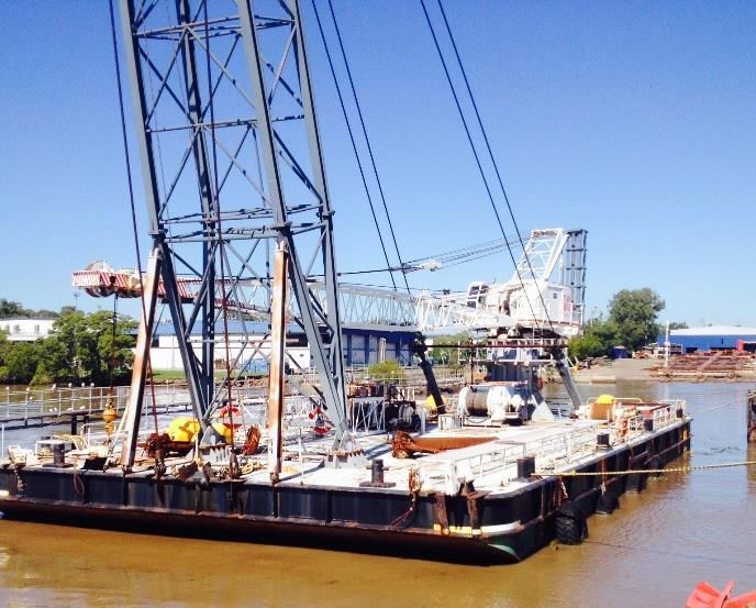
Marine Traffic Management Plan -
                                                                         One Sydney Harbour

      10.1.1 Exclusion Zone Demolition Stage Barge Position 1 ......................................................... 23
      10.1.2 Exclusion Zone Demolition Stage Barge Position 2 ......................................................... 23
      10.1.3 Exclusion Zone Construction Stage ................................................................................ 24
      10.1.4 Exclusion Zone Special Markers ..................................................................................... 24
      10.1.5 No Wash Zone ............................................................................................................... 24
      10.1.6 Diving Operations.......................................................................................................... 24
   10.2 Collision Prevention ............................................................................................................. 25
      10.2.1 Collison Regulations ...................................................................................................... 25
      10.2.2 Impact on Ferry Operations ........................................................................................... 25
      10.2.3 Impact on White Bay Shipping Operations..................................................................... 25
      10.2.4 Impact on Sydney Metro Barge Operations ................................................................... 26
      10.2.5 Navigation Lights and Day Shapes ................................................................................. 26
      10.2.6 Masters Certificate of Local Knowledge for Sydney Harbour .......................................... 27
      10.2.7 Anchor Watch ............................................................................................................... 27
   10.3 Vessel Safety Management Systems .................................................................................... 27
   10.4 Weather Forecasting ............................................................................................................ 27
   10.5 Bathymetric Channel Survey ................................................................................................ 27
11.       Minimum Crew Qualifications .............................................................................................. 27
12.       Operational and Emergency Procedures .............................................................................. 27
Appendix 1: Route Plan ................................................................................................................... 29
Appendix 2: LC 20 Mooring Arrangement Position 1 (Demolition Stage) .......................................... 30
Appendix 3: LC 20 Mooring Arrangement Position 2 (Demolition Stage) .......................................... 31
Appendix 4: LC 20 Mooring System Profile....................................................................................... 32
Appendix 5: Exclusion Zone LC 20 Position 1 (Demolition Stage) ...................................................... 33
Appendix 6: Exclusion Zone LC 20 Position 2 (Demolition Stage) ...................................................... 34
Appendix 7: Barge Positions and Exclusion Zone (Construction Stage) ............................................. 35
Appendix 8: Cruise Ship Schedule for White Bay (Demolition Stage) ................................................ 36
Appendix 9: Cruise Ship Schedule for White Bay (Construction Stage) ............................................. 37

                                                                 Marine Traffic Management Plan – One Sydney Harbour, Rev 4: 05112018
                                                                                                                          Page 4 of 37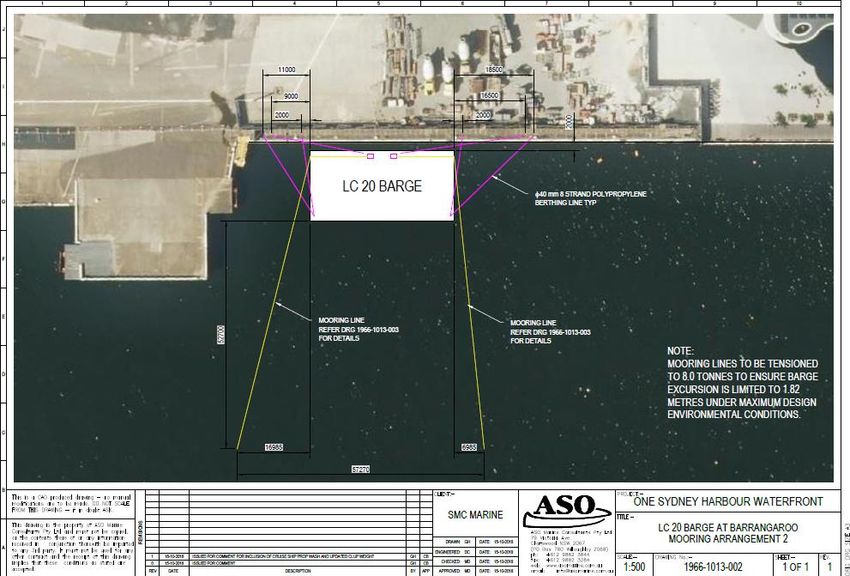
Marine Traffic Management Plan -
                                                       One Sydney Harbour

1. Purpose and Scope
The purpose of this plan is to manage marine traffic risks associated with demolition and
construction works for the One Sydney Harbour development at Barangaroo South, Darling Harbour
Sydney.

The scope of the plan includes the following:

•   The work site at One Sydney Harbour, Barangaroo South, Darling Harbour (33.863465809 S /
    151.200884146 E).
     - Northern boundary: Northern tip of the Popes Landing.
     - Southern boundary: 20 m to the north of Barangaroo Ferry Hub (BFH) Wharf 1.
•   Barangaroo Delivery Authority.
•   Lendlease Building: principal contractor to Barangaroo Delivery Authority.
•   SMC Marine: sub-contractor to Lendlease for the marine demolition and construction works.
•   Ausbarge Marine Services and Subsea Works: sub-contractors to SMC Marine.
•   Key stakeholders: Port Authority of NSW, Roads and Maritime Services and Harbour City Ferries
•   Tugs: Arana and HT Saipan (or similar).
•   Barge LC 20.
•   Barge SMC 2.
•   Dumb barges.
•   Dive vessel Trieste
•   Tug and barge transport between White Bay 2, Glebe Island 1 and the work site.
•   Aus chart 202.

The plan when approved by Port Authority of NSW becomes the primary document that SMC Marine
will use to manage marine transport and mooring for the works.

2. Description of works
2.1 Development Consent
Development Consent for the project has been granted by the NSW Government Department of
Planning & Environment Independent Planning Commission - Application no: SSD 7944. The project
has been classified as State Significant Development as described in State Significant Development
Assessment Report Public Domain Works, Barangaroo South and Central (SSD 7944), July 2018.
This Marine Traffic Management Plan is consistent with the following:
•   Barangaroo South Stage 1B Public Domain Navigation Impact Assessment: Royal Haskoning
    DHV, 24 January 2017.
•   Barangaroo Jetty and Pontoon Development: Port Authority of NSW, 25 October 2016.
•   Harbour Masters Directions - Sydney Harbour & Botany Bay: Port Authority of NSW, July 2016
•   LC20 Crane Barge Mooring Arrangement Report at Barangaroo Darling Harbour for SMC Marine:
    ASO Marine Consultants, 17 October 2018.
•   Submissions from Roads and Maritime Services on the Exhibition of EIS for Barangaroo Public
    Domain Works - SSD7944, 16 June 2016.
•   Submissions received from consultation between SMC Marine and Harbour City Ferries, 25
    October 2018.

                                                Marine Traffic Management Plan – One Sydney Harbour, Rev 4: 05112018
                                                                                                         Page 5 of 37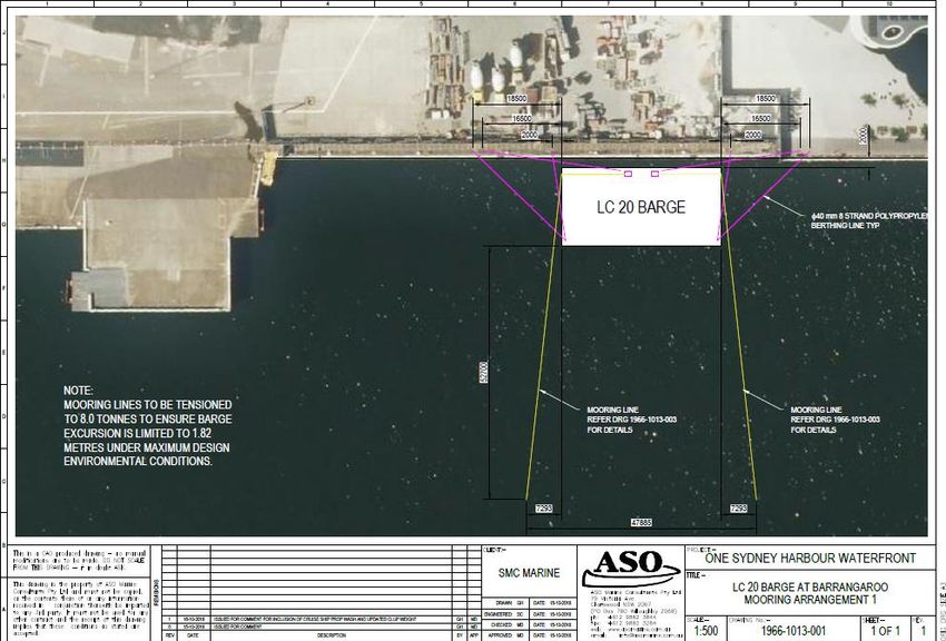
Marine Traffic Management Plan -
                                                      One Sydney Harbour

An Environment, Health & Safety (EHS) plan approved by Lendlease is in place for the project. Refer
to SMC Project EHS Plan - One Sydney Harbour Waterfront Structures Works.
Work will be mostly marine based and will be conducted from barges moored alongside the work
site at Barangaroo South.

The current aerial view of the site overlaid with the planned construction is shown below in Section
2.3. The Barangaroo Ferry Hub (BFH) Wharf 1 is approximately 25 m to the south-west of the
proposed construction.
2.2 Demolition
Marine traffic for demolition is proposed to commence on Monday 26 November 2018 and finish on
Friday 21 December 2018. Barges will demobilise on 21 December and the site will then be shut until
7 January 2019. Hours of work for marine traffic purposes are 06:00 to 18:00 Monday - Friday, and
06:00 - 13:00 Saturday. Demolition will generally involve the following:

•   Removal of 700 tonnes of concrete slab, headstocks and girders in maximum sections of 20
    tonnes, using the crane barge LC 20.
•   Removal of 17 steel piles using the crane barge LC 20 with the assistance of divers using
    underwater broco cutters.
•   Removal of demolished materials by dumb barge to White Bay 2.

The crane is a 2018 model Favell - Favco 8/10 K offshore rated crane compatible with the stability of
the LC 20 barge and is designed for safely undertaking 20 tonne lifts that are required for the
demolition, in a significant wave height of 0.5 m; the conditions expected from vessel wash and wind
fetch at the site.

Refer to the crane particulars for more information.

2.3 Construction
Marine traffic for construction is proposed to commence in early February 2019 and is expected to
continue until late October. Hours of work for marine traffic purposes are 06:00 to 18:00 Monday -
Friday, and 06:00 - 15:00 Saturday. Construction will generally involve the following:
•   Installation of 66 new steel piles with the SMC 2 barge.
•   Installation of 320 tonnes of new steel wharf substructure with the SMC 2 barge.
•   3500 sq/m of decking and associated timber and finishing works.
•   100 tonnes of sandstone works at the landward edge of the site.
•   Delivery of construction materials by dumb barge from White Bay 2 and Glebe Island 1.

The crane is a 2018 model Favell - Favco 5/10 K offshore rated crane compatible with the stability of
the SMC 2 barge.

The current aerial view of the site overlaid with the planned construction is shown below.

                                               Marine Traffic Management Plan – One Sydney Harbour, Rev 4: 05112018
                                                                                                        Page 6 of 37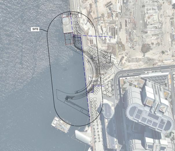
Marine Traffic Management Plan -
                      One Sydney Harbour

Image courtesy of Royal Haskoning DHV.

              Marine Traffic Management Plan – One Sydney Harbour, Rev 4: 05112018
                                                                       Page 7 of 37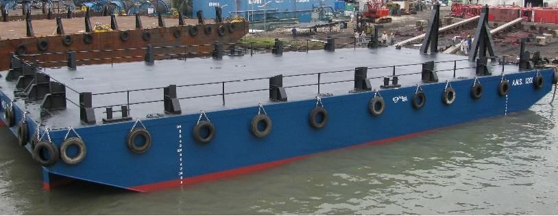
Marine Traffic Management Plan -
                                                            One Sydney Harbour

3. Vessel Particulars
All tugs and barges have current certificates of survey. Tugs and crane barges will operate under
their individual safety management systems (SMS). Dumb barges will operate under the towing tugs
SMS.

3.1 Proposed Tugs
Note: this is subject to change based operational requirements at the time, however like for like tugs will be
used.

3.1.1 Tug: Arana
Project role: Transport barge to and from site. Barge movements on site as required. Refer to
Ausbarge SMS Tug Arana for SMS details.
                                                         LOA                        14.8 m
                                                         Depth                      3.0 m
                                                         Breadth                    6.5 m
                                                         Tonnage                    79 t
                                                         Bollard Pull               10.38 t
                                                         Fuel capacity              22 m3
                                                         Survey                     2C
                                                         Vessel ID                  31366QC
                                                         Propulsion                 Twin Screw fixed nozzles design speed 10
                                                                                    knots
                                                         Main Engines               2 x Yanmar 6HA2M - WDT
                                                         Genset                     2 x Yanmar
                                                         Communication              VHF, HF, UHF
                                                         Navigation                 GPS, Compass

3.1.2 Tug: HT Saipan
Project role: Transport barge to and from site. Barge movements on site as required. Refer to
Ausbarge SMS HT Saipan for SMS system details.
                                                                    LOA                      16.0 m
                                                                    Depth                    2.9 m
                                                                    Breadth                  6.0 m
                                                                    Tonnage                  70 t
                                                                    Bollard Pull             14 t
                                                                    Fuel capacity            20 m3
                                                                    Survey                   2C
                                                                    Vessel ID                31173QC
                                                                    Propulsion               Twin Screw fixed nozzles design
                                                                                             speed 10 knots
                                                                    Main Engines             2 x Volvo D12-500
                                                                    Genset                   Perkins 422T
                                                                    Communication            VHF, HF, UHF
                                                                    Navigation               GPS, Compass

                                                     Marine Traffic Management Plan – One Sydney Harbour, Rev 4: 05112018
                                                                                                              Page 8 of 37
Marine Traffic Management Plan -
                                                      One Sydney Harbour

3.2 Proposed Barges
3.2.1 Crane Barge: LC 20
Project role: Lifting operations involved with the demolition, including pile and concrete removal.
Refer to SMC Marine SMS Barge LC 20 for SMS details. Note: the sheerlegs shown in the photo will
not be fitted.
                                                       Vessel Name              LC 20
                                                       Previous Names           Big Boy
                                                       Vessel Type              Barge
                                                       Year Built               1981 Steelmains Pty Ltd, Hobart
                                                                                Tasmania
                                                       Construction             Steel with water tight bulkheads: 1 x
                                                                                longitudinal / 4 x athwartships.
                                                       Flag                     Australia
                                                       Port of Registry         Sydney
                                                       Official no              855826
                                                       IMO Number               NA
                                                       Classification Society   American Bureau of Shipping (ABS)
                                                       Class                    A1 (ABS)
                                                       Class Number             8123763 (ABS)
                                                       Survey                   2A
                                                       LOA                      33.3 m
                                                       Max breadth              16.3 m
                                                       Moulded depth            2.4 m
                                                       amidships
                                                       Load Line                1040 mm
                                                       GRT                      342 t
                                                       Deadweight               308 t
                                                       Displacement             713 t
                                                       Deck Capacity            10 t / m2
                                                       Mooring System           4 point: 12 t hydraulic winches with
                                                                                1.5 t anchors and 28 mm FSWR
                                                       Crane                    Favelle/ Favco 50 t SWL with 41. 2 m
                                                                                lattice boom. Vessel mounted on
                                                                                pedestal. 400 kW diesel hydraulic
                                                                                powerpack. Weight 68 t
                                                       Generator                78 kW Caterpillar diesel
                                                       Fuel Capacity            4700 L (3.9 t at 0.83 SG)
                                                       Electrical               240 / 415 V
                                                       Fresh Water              4700 L (4.7 t at 1.0 SG)
                                                       Ballast                  2 x 5690 L tanks aft P & S (56.9 t FW
                                                                                / 58.32 t SW)

                                               Marine Traffic Management Plan – One Sydney Harbour, Rev 4: 05112018
                                                                                                        Page 9 of 37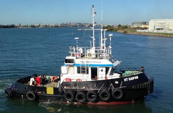
Marine Traffic Management Plan -
                                                      One Sydney Harbour

3.2.2 Piling and Crane Barge: SMC 2
Role: Piling and lifting operations involved with construction. Refer to SMC Marine SMS Barges for
SMS details.
                                                          LOA                24.2 m
                                                          Breadth            12.3
                                                          Depth              2.10
                                                          Survey             2E
                                                          Vessel ID          24282
                                                          Deck capacity      10 t m2
                                                          Crane              Favell Favco 20 t with 27.4 m boom
                                                          Mooring System     4 x spuds (deployed by crane)
                                                                             4 point anchor / winch system

3.2.3 Dumb Barge (Example)
Role: Transport of demolished material to White Bay 2. Delivery of new materials and equipment to
the site.
                                                                  LOA                  27 m
                                                                  Breadth              12.0 m
                                                                  Depth                2.10 m
                                                                  Survey               2D
                                                                  Vessel ID            Various
                                                                  Deck capacity        10 t sq/m

                                               Marine Traffic Management Plan – One Sydney Harbour, Rev 4: 05112018
                                                                                                       Page 10 of 37
Marine Traffic Management Plan -
One Sydney Harbour
4. Crane Particulars
4.1 Favell Favco 8/10 K with 41.2 m boom mounted on LC20
Marine Traffic Management Plan – One Sydney Harbour, Rev 4: 05112018
Page 11 of 37Marine Traffic Management Plan -
One Sydney Harbour
Marine Traffic Management Plan – One Sydney Harbour, Rev 4: 05112018
Page 12 of 37Marine Traffic Management Plan -
One Sydney Harbour
4.2 Favelle Favco 5/10 K Crane with 27.4 m boom - SMC 2 Barge
Marine Traffic Management Plan – One Sydney Harbour, Rev 4: 05112018
Page 13 of 37Marine Traffic Management Plan -
One Sydney Harbour
Marine Traffic Management Plan – One Sydney Harbour, Rev 4: 05112018
Page 14 of 37Marine Traffic Management Plan -
One Sydney Harbour
5. Mobilisation and Demobilisation
Refer to Appendix 1 for the Route Plan to and from the One Sydney Harbour Site.
The SMC Yard at White Bay 2 will be the primary offsite load out and set down area for the barges as
well as for berthing when not required.
Piles and other steel members for the construction stage will be delivered by ship to Glebe Island 1
and unloaded from the ship to barges alongside. A permit from PANSW has been obtained to use the
berth.
A crane barge will remain at One Sydney Harbour for the majority of the demolition and
construction stages.
One dumb barge is proposed to be in operation for the entire time. Other dumb barges may be
required intermittently; however, it is not envisaged that more than one dumb barge will be at the
One Sydney Harbour site at the same time.
SMC will implement any conditions detailed in the Harbour Masters Permit.
5.1 Indicative Schedule of Vessel Movements (Demolition Stage)
Note: dates and times are subject to change based on site conditions, weather conditions, the White Bay Cruise
Terminal shipping schedule and Lendlease requirements.
Mobilisation and site establishment for the demolition phase is proposed to take place on Monday
26 November 2018. No ship arrivals or departures are scheduled for the White Bay Cruise Terminal
on that day. Demobilisation is proposed to take place on Friday 21 December 2018. Times have been
chosen to avoid the Seabourn Encore and Maasdam arriving and departing on that day.
There will be no site works between 22 December 2018 and 6 January 2019.
HT Saipan will transport the barge LC 20.
Arana will deliver and collect dumb barges containing demolished materials during the demolition
stage as required. This is likely to be one or two days a week, possibly Tuesdays and Fridays, at some
time between 15:00 -18:00 to avoid shipping into White Bay.
Monday 26 November (approx)
07:30 HT Saipan and barge LC20 depart White Bay 2 for One Sydney Harbour.
07:45 HT Saipan and LC20 arrive One Sydney Harbour.
08:00 Site establishment, including:
• deployment of barge mooring anchors
• deployment of sediment containment boom around worksite (by work punt)
Refer to Mooring Plan for details
09:00 HT Saipan Departs Ones Sydney Harbour for White Bay 2.
Dumb barge delivery from Tuesday 27 November (once or twice a week)
07:00 Arana and dumb barge depart White Bay 2 for One Sydney Harbour.
07:15 Arana and dumb barge arrive One Sydney Harbour.
07:30 Arana departs One Sydney Harbour for White Bay 2.
07:45 Arana arrives White Bay 2.
Dumb barge collection when ready (once or twice a week)
16:45 Arana departs White Bay 2 for One Sydney Harbour.
17:00 Arana arrives One Sydney Harbour.
17:15 Arana and dumb barge depart One Sydney Harbour for White Bay 2
17:30 Arana and dumb barge arrive White Bay 2.
Marine Traffic Management Plan – One Sydney Harbour, Rev 4: 05112018
Page 15 of 37Marine Traffic Management Plan -
One Sydney Harbour
Friday 21 December
14:30 HT Saipan departs White Bay 2 for One Sydney Harbour
14:45 HT Saipan arrive One Sydney Harbour
15:00 Site disestablishment, including:
• retrieval of barge mooring anchors
• retrieval of sediment containment boom (by work punt)
16:00 HT Saipan and LC20 departs One Sydney Harbour
17:15 HT Saipan and barge LC20 arrive White Bay 2.
5.2 Indicative Schedule of Vessel Movements (Construction Stage)
Note: dates and times are subject to change based on site conditions, weather conditions, the White Bay Cruise
Terminal shipping schedule and Lendlease requirements.
A ship delivering the steel piles and modules for the project will berth at Glebe Island 1 at some time
between 1 and 10 February 2019. Piles and steel modules will be unloaded from the ship directly
onto the SMC 2 barge and dumb barges alongside which will then either be transported to White
Bay 2 or berthed at Glebe Island 1 for a short time to stand by for mobilisation to One Sydney
Harbour as required.
Mobilisation and site establishment for the construction phase is proposed to take place on Monday
11 February. Times have been chosen to avoid the Pacific Explorer due at White Bay at 07:00 that
day. Demobilisation is proposed for a date to be advised in late October 2018.
Arana will transport the barge SMC 2 and construction dumb barges to and from White Bay 2.
Delivery of piles and modules on dumb barges will take place at a frequency of no more than once
per week on any week day between 07:00 and 10:00, at a time to avoid ship movements at White
Bay.
Unloading pipes from ship at Glebe Island 1: Friday 1 February – Sunday 10 February (TBC)
07:00 Arana and SMC 2 depart White Bay 2 for Glebe Island 1.
07:10 Arana and SMC 2 arrive Glebe Island 1
12:00 Arana and SMC 2 depart Glebe Island 1
12:10 Arana and SMC 2 arrive White Bay 2
12:20 Arana and Dumb barge depart White Bay 2 for Glebe Island 1.
12:30 Arana and dumb barge arrive Glebe Island 1
17:30 Arana and dumb barge depart Glebe Island 1
17:40 Arana arrive and dumb barge arrive White Bay 2
Mobilisation to site Monday 11 February, 2018
07:30 Arana and barge SMC 2 depart White Bay 2 for One Sydney Harbour.
07:45 Arana and SMC 2 arrive One Sydney Harbour.
08:00 Site establishment, including:
• deployment of barge spuds
• deployment of sediment containment boom around worksite (by work punt).
Refer to Mooring Plan for details
09:00 Arana Departs One Sydney Harbour for White Bay 2.
Dumb barge delivery, from Tuesday 12 February.
07:00 Arana and dumb barge depart White Bay 2 for One Sydney Harbour.
07:15 Arana and dumb barge arrive One Sydney Harbour.
07:30 Arana departs One Sydney Harbour for White Bay 2.
07:45 Arana arrives White Bay 2.
Dumb barge collection when ready
16:45 Arana departs White Bay 2 for One Sydney Harbour.
17:00 Arana arrives One Sydney Harbour.
17:15 Arana and dumb barge depart One Sydney Harbour for White Bay 2.
Marine Traffic Management Plan – One Sydney Harbour, Rev 4: 05112018
Page 16 of 37Marine Traffic Management Plan -
One Sydney Harbour
17:30 Arana and dumb barge arrive White Bay 2.
Late October 2018
14:30 Arana departs White Bay 2 for One Sydney Harbour.
14:45 Arana arrive One Sydney Harbour.
15:00 Site disestablishment, including:
• retrieval of barge mooring anchors
• retrieval of hydrocarbon / sediment containment (by work punt).
16:00 Arana and LC20 departs One Sydney Harbour
17:15 Arana and barge LC20 arrive White Bay 2.
6. Tow Arrangement
The preferred tow arrangement will be at the Master’s discretion and will be determined by factors
such as sight lines from the wheelhouse, manoeuvring characteristics of a particular barge, wind and
tide conditions, and the desired angle of approach to the mooring site. Generally, there are two
options as shown below.
Option 1
Pushing from stern.
Tug Barge
Option 2
Hipped up on either the port or starboard side.
Barge
Tug
Marine Traffic Management Plan – One Sydney Harbour, Rev 4: 05112018
Page 17 of 37Marine Traffic Management Plan -
One Sydney Harbour
7. Mooring Arrangements
The proposed mooring arrangements have been determined by the following:
• The barges and cranes designed to safely undertake the required demolition and construction
tasks at the site under the varying marine conditions present at Barangaroo.
• The desire to keep the anchor scope as short as possible to minimise the impact on passing
vessels, the Barangaroo Ferry Hub, and White Bay cruise ships while ensuring adequate holding
power for the barges.
• Harbour Masters Directions.
The likely arrangements are described below. Minor adjustments to the mooring arrangement are to
be expected as conditions on site change through the evolution of demolition and construction.
7.1 Demolition Stage
It is envisaged that two barge positions will be required for the LC 20 to complete the demolition,
requiring the barge to be moved approximately 42 m North from position one to position two at
approximately two weeks from the commencement date.
7.1.1 Mooring specifications
Refer to Appendix 2 and 3 for the mooring arrangements proposed for the two barge positions at
the site.
Naval Architects from ASO Marine Consultants have designed the mooring arrangements to provide
more than sufficient holding power to withstand the conditions expected on site. The design takes
into account a worst case scenario combining expected cruise ship prop wash with 72 knot winds.
The following parameters were taken into account in the design:
• Estimated position of mooring 1:
- 33.863541878 S /151.200776942 E
- 74 m north of BFH Wharf 1A.
- 82 m south of corner between wharf face and Popes Landing.
• Estimated position of mooring 2:
- 33.863168818 S /151.200741402 E
- 116 m north of BFH Wharf 1 A.
- 40 m south of corner between wharf face and Popes Landing.
• Mooring design life: 6 months (note that only 1 month will be required on site for demolition).
• Current: 2 knots along the quay line.
• Wind: 37 m/s.
• Maximum vessel wake wash: 0.5 m significant wave height
• Cruise ship propeller wash: 1.5 m/s from the North and North West (Royal Haskoning DHV,
2017)
• Water depth: 14 m
• Harbour bed: soft sediment
Two anchors will be deployed at a maximum of 70 m out from the wharf to be demolished. By the
use of a clump weight, the anchor scope was able to be kept at 5:1 and the anchor wire will not
begin to rise from the harbour bed until approximately 62 m out from the wharf. The exclusion zone
Marine Traffic Management Plan – One Sydney Harbour, Rev 4: 05112018
Page 18 of 37Marine Traffic Management Plan -
One Sydney Harbour
described in Section 10 was thus able to be kept to 70 m from the wharf, providing sufficient
clearance for passing vessels to navigate into Barangaroo Ferry Hub, Darling Harbour and White Bay.
In comparing the mooring arrangement to the Perceived Concerns and Mitigating Controls described
in Section 6 of Barangaroo Jetty and Pontoon Development, Port Authority of NSW 2016, the anchors
on the harbour bed for the Northern most mooring position will be more than 30 m from the closest
point of approach for cruise ships using the swing basin, and the barge on the surface will be more
than 80 m.
The mooring design has taken into account prop wash from cruise ships using the swing basin based
on data provided in Barangaroo South Stage 1B Public Domain Navigation Impact Assessment: Royal
Haskoning DHV, 24 January 2017, as well as Barangaroo Jetty and Pontoon Development, Port
Authority of NSW 2016.
The mooring system components to be used in order to satisfy the design are described below. Refer
to Appendix 4 for the mooring profile showing these components on the harbour bed. The system
will be assembled on the barge at White Bay 2 prior to mobilisation.
Component Description Capacity
Winches x 4 Hydraulic 12 t 12 t SWL
Anchors 1.5 t Flipper Delta (21 -39 t holding capacity) 21 – 39 t holding capacity
Clump Weight 5 t concrete NA
Ground tackle 4 m x 38 mm stud link chain linked with 12.5 t WLL shackle 350 kN MBL
Anchor wire 28 mm FSWR with hard eye and thimble 350 kN MBL
Shackles Bow shackle with safety pin and nut (moused) 12.5 t WLL 12.5 t WLL / 695 kN MBL
Berthing lines 6 X 40 mm eight strand polypropylene rope to 20 mm chain 255 kN MBL
with sleave around pile, linked by 12.5 t shackle.
Anchor pennant 40 mm with strand polypropylene rope. 255 kN MBL
MBL = Minimum Breaking Capacity, SWL = Safe Working Load, WLL = Working Load Limit
The amount of wire to pay out in order to satisfy the design is as follows:
Anchor scope 5:1 at 14 m depth
Rhode to pay out on winch from fairlead 70 m
Distance of anchor across ground from 70 m
wharf
7.1.2 Indicative Mooring Procedure
The Barge Supervisor will direct and supervise all barge and mooring operations and will lead a Tool
Box Meeting with all participants before commencing, ensuring that all participants understand their
roles and that clear communication is maintained throughout the procedure. Two options are being
considered. The Barge Supervisor will decide which option to follow on the day taking into account
the conditions at the time.
Mooring Procedure Option 1
1. The tug will hold the barge steady while the barge is made off with six berthing lines to piles
under the wharf at distance of 2 - 2.5 m off the wharf. A 20 mm chain eye with protective sleave
will be placed around the pile from the work punt and connected by 12.5 t shackle to a 40 mm
eight strand polypropylene line made off to bits on the barge.
Marine Traffic Management Plan – One Sydney Harbour, Rev 4: 05112018
Page 19 of 37Marine Traffic Management Plan -
One Sydney Harbour
2. The crane will lift the anchor and clump weight from the deck of the barge to the bow of the tug
with the anchor pennant made off to the tugs H bit so that the anchor sits just below the water
line.
3. The crane will lower the anchor further so that the tug takes the load with the anchor pennant.
When the crane sling goes slack it will be disconnected from the anchor by crew in a work punt.
Crew on the tug and in the punt will be above the load at all times.
4. The tug will head astern as the winch is paid out from the barge until a scope of around 5 times
water depth is obtained (approximately 70 m at 14 m depth).
5. The anchor will be released from the H bit and a special marker with a 2 NM flashing light
attached to the anchor pennant from the work punt after the anchor lands on the bottom.
6. The winch wire will be tensioned from the barge and the anchor will bite into the harbour bed.
7. One tonne special marker moorings will be deployed from a work boat with a 3 t slewing crane,
at 70 m from the wharf to mark an exclusion zone around the site. When the mooring line goes
slack (indicating the mooring is on the bottom) a special marker with 2 NM flashing light will be
attached.
8. A sediment containment boom will be deployed around the site by work punt and made off to
the barge and piles on either side of the site.
9. Dumb barges delivered by tugs will berth alongside the LC 20 with either 32 mm 3 strand
polyethylene rope or 32 mm 8 strand polypropylene rope as, shown below.
10. Anchor retrieval:
• The barge winch wire will be slackened.
• The special marker will be unattached by crew in a work punt.
• The anchor pennant will be heaved up and made off to the tug H bit on the bow.
• The tug will go astern to lift the anchor out of the mud, until the anchor is visible just below
the water line
• The barge winch will wind the wire in to approximately 10 m from the barge with the tug
holding the anchor.
• The crane slings will be attached to the anchor by crew in a work punt.
• The crane will take the load of the anchor and the pennant will be released once it goes slack
by crew on the tug.
• The crane will lift the anchor and clump weight on to the barge.
Mooring Procedure Option 2
1. The tug will hold the barge steady at the approximately 60 m directly out from the wharf where
the barge is to be moored.
2. The crane will lift the anchor and clump weight for each mooring off the barge and in to the
water by the anchor pennant. A small amount of tension will be applied to the winch from the
barge to ensure the clump weight lands the correct way up. The clump weight will touch the
bottom first at approximately 65 m from the wharf and the crane will slew another 6 m further
out and continue lowering the anchor until it touches the bottom.
Marine Traffic Management Plan – One Sydney Harbour, Rev 4: 05112018
Page 20 of 37Marine Traffic Management Plan -
One Sydney Harbour
3. When the pennant goes slack (indicating the anchor is on the bottom), the slings will be
unattached from the pennant by crew in a work punt and a special marker attached to the
pennant.
4. One tonne special marker moorings will be deployed approximately 20 m either side of the
anchors (parallel with the wharf) by the crane. When the mooring line goes slack indicating the
mooring is on the bottom), the slings will be unattached, and a special marker will be attached
by crew in a work punt
5. The tug will slowly push the barge in to the wharf while the two winches pay out the winch wire.
6. The tug will hold the barge steady while the barge is made off with six berthing lines to piles
under the wharf at distance of 2 - 2.5 m off the wharf.
7. The winch wires will be tensioned from the barge and the anchors will bite into the harbour bed.
8. Special marker moorings will be deployed by the crane to mark the southern exclusion zone
boundary and special markers attached by work punt.
9. Anchor retrieval:
• The six berthing lines on the wharf will be released.
• The tug will slowly pull the barge out from the wharf to the anchor position while winch wire
is taken in from the barge.
• The special marker will be removed from the anchor pennant and the crane slings attached
to the pennant from the work punt.
• The crane will slew out from the wharf to drag the anchor out of the mud and lift the anchor
and clump weight on to the barge. The anchor and clump weight will be held off the bottom
for a short time before completing the lift to give any sediment a chance to dislodge before
coming to the surface.
7.1.3 Dumb barge berthing arrangement
Marine Traffic Management Plan – One Sydney Harbour, Rev 4: 05112018
Page 21 of 37Marine Traffic Management Plan -
One Sydney Harbour
7.2 Construction Stage
The SMC 2 barge will be used during construction and will be moored with steel spuds (600 mm x 24
m). Refer to Appendix 5 for the various positions the barge is likely to be moored. Work will
generally take place from the southern site boundary, working towards the north.
7.2.1 Mooring procedure
1. The barge will be made off to piles under the wharf in a similar manor as described for the LC20,
with the tug holding it steady.
2. The crane will position the spuds while the tug holds the barge steady. The spuds will be locked
off when in position.
3. The sediment containment boom and exclusion zone special markers will be deployed.
4. Dumb barges will berth alongside the SMC 2, with berthing lines made off in the same
arrangement as shown for the LC 20.
8. Communication
A Harbour Masters Instruction will need to be published on the NSW Port Authority Website and
broadcast daily by Vessel Traffic Services (VTS) Sydney. Exact dates and times for the VTS including
onsite barge manoeuvring involving anchor deployment and retrieval will be confirmed as per Notice
to Mariners No. 19 of 2017.
The Site Supervisor is to email each days work schedule to Sydney Ports Vessel Traffic Service (VTS),
the Lendlease Senior Site Manager and Structures Foreman, and Harbour City Ferries Operations
Control, the day before the works.
Communication between the tug and barge on site will be verbal when in vocal range and by two
way radio when out of vocal range. The Site Supervisor will also have the mobile phone number of
the tug Master and Dive Supervisor for communication at other times.
Communication and radio watch between Sydney Ports VTS and the tug will take place on VHF
Channel 13, with all switching over to the working channel specified by VTS at the required time.
Distress watch will also take place on VHF Channel 16.
Radio watch will be maintained at all times during towing and tug operations.
The tug Master will report to VTS Channel 13 before departure from White Bay 2, Glebe Island 1 and
Barangaroo.
Harbour City Ferries Operational Control will notify ferry Master’s via VHF radio and the weekly
bulletin.
8.1 Project Contact List:
Name Role Phone Email
Chien Choong Senior Project Engineer: 0429 963 185 chien.choong@lendlease.com
Lendlease = One Sydney Harbour
Murray Graham Senior Site Manager: Lendlease - 0438 839 444 murray.graham@lendlease.com
One Sydney Harbour
Farrell Knox Site Foreman: Lendlease - One 0405 445 405 farrell.knox@lendlease.com
Sydney Harbour
Niall Magee SMC General Manager 0451 512 974 niall@smcmarine.com.au
Jack Atkinson SMC Project Manager 0431 598 758 jacka@smcmarine.com.au
Sam Webb SMC Barge Supervisor 0401377267 sam@smcmarine.com.au
Mal Finnan SMC Marine HSE Coordinator 0407 942 011 mal@smcmarine.com.au
Marine Traffic Management Plan – One Sydney Harbour, Rev 4: 05112018
Page 22 of 37Marine Traffic Management Plan -
One Sydney Harbour
Scott Mitchell Subsea Works Dive Suerpvisor 0447 782 732 scott@subseaworks.com.au
Sharad Bhasin Manager, Compliance and 0409 811 810 sbhasin@portauthoritynsw.com.au
Planning, Port Authority of NSW
Dan Duemmer RMS Manager Operations 02 9563 8504 daniel.duemmer@rms.nsw.gov.au
Harbour City Operations Control VHF CH 1 opscontroller@harbourcityferries.com.au
Ferries
Ray Windle Harbour City Ferries Operations 0404 473 925 raymond.windle@harbourcityferries.com.au
Manager
VTS Sydney Vessel Traffic Service VHF Ch 13 vts@portauthoritynsw.com.au
9296 4999
Greg Hall Director – Ausbarge Marine 0438 091 286 greghall@ausbarge.com
Services
8.2 Emergency Contacts:
Emergencies on Harbour 000
Port Authority of NSW 9296 4003
VTS Sydney VHF Channel 13
NSW Water Police 9320 7499
Harbour City Ferries VHF Channel 1
9. Risk Assessment
A detailed risk assessment covering all aspects of the project is contained in SMC Project EHS Plan -
One Sydney Harbour Waterfront Structures Works.
Risk assessments for operations on board each tug and barge are included as part of the respective
vessel safety management system.
10. Marine Traffic Controls
10.1 Exclusion Zone
SMC Marine requests a Harbour Masters Instruction (Exclusion Zone) is published on the NSW Port
Authority Website and broadcast daily by Vessel Traffic Services (VTS) Sydney. Exact dates and times
for the VTS including onsite barge manoeuvring involving anchor deployment and retrieval will be
confirmed as per Notice to Mariners No. 19 of 2017. Aus 202 is the chart affected by the works.
The boundary of the exclusion zone will be confirmed after deployment. A distance of 70 from the
wharf has been chosen to be consistent with the mooring arrangement, minimise the impact on
vessels navigating into the Barangaroo Ferry Hub, Darling Harbour and White Bay, and to minimise
confusion with backscatter from Barangaroo with the special marker lights at night.
10.1.1 Exclusion Zone Demolition Stage Barge Position 1
Refer to Appendix 5 for an overview of the exclusion zone.
The southern exclusion zone boundary will run at right angles with the wharf approximately 59 m
north of the BFH 1 north west corner. The boundary running south to north along the site will be
parallel with and approximately 70 m from the wharf before tapering in at the north to finish at the
Popes Landing south west corner.
10.1.2 Exclusion Zone Demolition Stage Barge Position 2
Refer to Appendix 6 for an overview of the exclusion zone
The southern exclusion zone boundary will run at right angles with the wharf approximately 74 m
north of the BFH 1 north west corner. The boundary running south to north along the site will be
Marine Traffic Management Plan – One Sydney Harbour, Rev 4: 05112018
Page 23 of 37Marine Traffic Management Plan -
One Sydney Harbour
parallel with and approximately 70 m from the wharf before tapering in at the north to finish at the
Popes Landing north west corner.
10.1.3 Exclusion Zone Construction Stage
Refer to Appendix 7 for an overview of the exclusion zone
The southern exclusion zone boundary will run parallel with and 20 m to the north east of BFH 1,
with markers 5 m off the construction boundary line. The boundary running south to north along the
site will be parallel with and approximately 70 m from the wharf before tapering in at the north to
finish at the Popes Landing north west corner.
10.1.4 Exclusion Zone Special Markers
Yellow special marker buoys with 2 NM yellow flashing lights will be deployed to mark the exclusion
zone boundary, as shown below. These will be spaced at approximately 30 m intervals and held in
place with 1 t biscuit moorings:
10.1.5 No Wash Zone
A no wash zone will be required as part of the Harbour Masters Instruction for both stages of the
works. SMC request this is also broadcast on VHF Channel 13 as per the VTS broadcast schedule. The
‘RY’ No Wash flag combination will be displayed from the barge during the day time, as shown
below.
10.1.6 Diving Operations
The dive vessel Trieste (7.5 x 2.5 m) and dive team will be engaged to assist with pile removal during
the demolition phase and as required during construction. The vessel is in 2D Survey and will be
navigated by a Coxswain. All divers have ADAS Diver qualifications with the Dive Supervisor qualified
as an ADAS Dive Supervisor.
Marine Traffic Management Plan – One Sydney Harbour, Rev 4: 05112018
Page 24 of 37Marine Traffic Management Plan -
One Sydney Harbour
The Dive Supervisor will notify VTS of intended diving operations each day and upon completion. All
diving will comply with AS/NZS 2299: Occupational Diving Operations and will be contained within
the exclusion zone.
The Alpha flag (Diver Below) as shown below will be displayed for all diving operations where it can
best be seen by vessel traffic.
10.2 Collision Prevention
10.2.1 Collison Regulations
All tug and barge operations will comply with all relevant controls in the International Regulations
for the Prevention of Collisions at Sea, Harbour Masters Directions and the practice of good
seamanship.
10.2.2 Impact on Ferry Operations
All barge movements will be timed to avoid ferry arrivals and departures at the adjacent Barangaroo
Ferry Hub, however given the proximity of the site and exclusion zone to the ferry hub, ferry masters
are requested to use caution, minimise wash and to navigate their approach and departure from the
wharf well clear of the exclusion zone marked by yellow special marker buoys with flashing lights.
The southern boundary of the exclusion zone during the demolition stage for barge position 1 is
approximately 59 m from the BFH 1, and 74 m for barge position 2.
The southern boundary of the exclusion zone during the construction phase is 20 m from BFH 1.
Barge operations at the southern extremity of the site during the construction stage are planned to
commence from the southern boundary working towards the north west, with the barge oriented as
shown in Appendix 7. This will not impact on ferry operations at the BFH 1A
There will be audible noise for passengers however this will kept to within the hours allowed by the
development consent, with SMC Marine employing all technology available to ensure noise is kept
to a minimum. Noise monitoring will also take pace adjacent to the Ferry Hub.
The sediment containment boom will be secured to piles in such a fashion that it does not present a
hazard to ferries.
10.2.3 Impact on White Bay Shipping Operations
All barge movements and lifting operations at the One Sydney Harbour site will be timed to avoid
ship movement in the swing basin. Appendix 8 has the cruise ship arrival and departure schedule for
White Bay Cruise Terminal during the demolition stage and Appendix 9 for the construction stage.
The schedule will be monitored to ensure shipping is avoided.
Marine Traffic Management Plan – One Sydney Harbour, Rev 4: 05112018
Page 25 of 37Marine Traffic Management Plan -
One Sydney Harbour
The anchors on the harbour bed for the northern most mooring position will be more than 30 m
from the closest point of approach for cruise ships using the swing basin, and the barge on the
surface will be more than 80 m.
The mooring design has taken into account prop wash from cruise ships using the swing basin based
on data provided in Barangaroo South Stage 1B Public Domain Navigation Impact Assessment: Royal
Haskoning DHV, 24 January 2017, as well as Barangaroo Jetty and Pontoon Development, Port
Authority of NSW 2016
10.2.4 Impact on Sydney Metro Barge Operations
The route plan for the project will not impact on the route plan for barge works between the Sydney
Metro barging facility at Barangaroo and Clyde or Blues Point as the facility is approximately 250 m
to the north of the most Northern OSH site boundary.
The scope of this Marine Traffic Management Plan includes Ausbarge Marine Services who are the
same company engaged for both projects. All scheduling for OSH barge operations will be
coordinated through the Ausbarge Operations Manager responsible for the Sydney Metro barge
operations.
10.2.5 Navigation Lights and Day Shapes
If barge movement is required at night or in restricted visibility, the tug will display port and
starboard steaming lights, a stern light, a masthead light and an additional towing light for a tow <
50 m, with the barge displaying port and starboard lights, as shown below (head on view).
The barge will display a black ball in daylight hours and an all round white light between dusk and
dawn, as shown below.
Marine Traffic Management Plan – One Sydney Harbour, Rev 4: 05112018
Page 26 of 37Marine Traffic Management Plan -
One Sydney Harbour
10.2.6 Masters Certificate of Local Knowledge for Sydney Harbour
The tug Master will have a Certificate of Local Knowledge for Sydney Harbour and will report to VTS
Channel 13 when departing White Bay and One Sydney Harbour with barges.
10.2.7 Anchor Watch
Anchor watch is not expected to be required while the barge is unattended at night as the barge will
be made off to piles under the wharf with four berthing lines in addition to the mooring
arrangement. Additional berthing lines will be attached if severe storms or wind greater than 70
knots are forecast.
10.3 Vessel Safety Management Systems
All operational and emergency procedures described in the tug and barge Safety Management
System are to be followed.
10.4 Weather Forecasting
BOM weather forecasts will be monitored throughout the works via the internet and VHF Channel
16. Site establishment and barge movements on site will be postponed if severe storms are forecast
for the scheduled times.
All lifting operations will take place within the cranes wind operating limits.
10.5 Bathymetric Channel Survey
SMC Marine can arrange for a bathymetric survey of the channel area affected by anchoring at the
completion of the works, if directed by the Port Authority of NSW.
11. Minimum Crew Qualifications
Role Qualification
Tug Master Master < 24 m, MED Grade 3, Certificate of Local Knowledge for Port
Jackson
Tug Deck Hand General Purpose Hand
Barge Supervisor 20 Years’ experience in barge / crane operations, C1 HRW Licence, DG
HRW Licence, Restricted Demolition Licence.
Crane Operator C6 HRW Licence
Dogmen DG HRW Licence
Dive Boat Master Coxswain
Dive Supervisor ADAS Dive Supervisor
Divers ADAS Diver
Work punt operator Exemption 38.
12. Operational and Emergency Procedures
All tugs and the barge SMC 2 have NSCV compliant Safety Management Systems, featuring
procedures for all onboard operations, as well as emergency procedures for the following:
• Man Overboard
• Fire
• Collision / Grounding
• Flooding
• Abandon Ship
Marine Traffic Management Plan – One Sydney Harbour, Rev 4: 05112018
Page 27 of 37Marine Traffic Management Plan -
One Sydney Harbour
• Fuel / Oil Spill
• Injury on board
The barge LC 20 has an International Safety Management (ISM) Code Safety Management System.
All tugs and barges have fire fighting equipment, first aid equipment and emergency spill kits
applicable to the relevant survey requirements.
Emergency response for the project is detailed SMC Project EHS Plan - One Sydney Harbour
Waterfront Structures Works and includes procedures for site evacuation.
Marine Traffic Management Plan – One Sydney Harbour, Rev 4: 05112018
Page 28 of 37Marine Traffic Management Plan -
One Sydney Harbour
Appendix 1: Route Plan
OSH
Glebe Island 1
Tug and barge routes between White Bay 2, Glebe Island 1 and One Sydney Harbour Barangaroo.
Marine Traffic Management Plan – One Sydney Harbour, Rev 4: 05112018
Page 29 of 37Marine Traffic Management Plan -
One Sydney Harbour
Appendix 2: LC 20 Mooring Arrangement Position 1 (Demolition Stage)
Marine Traffic Management Plan – One Sydney Harbour, Rev 4: 05112018
Page 30 of 37Marine Traffic Management Plan -
One Sydney Harbour
Appendix 3: LC 20 Mooring Arrangement Position 2 (Demolition Stage)
Marine Traffic Management Plan – One Sydney Harbour, Rev 4: 05112018
Page 31 of 37Marine Traffic Management Plan -
One Sydney Harbour
Appendix 4: LC 20 Mooring System Profile
Marine Traffic Management Plan – One Sydney Harbour, Rev 4: 05112018
Page 32 of 37Marine Traffic Management Plan -
One Sydney Harbour
Appendix 5: Exclusion Zone LC 20 Position 1 (Demolition Stage)
Marine Traffic Management Plan – One Sydney Harbour, Rev 4: 05112018
Page 33 of 37Marine Traffic Management Plan -
One Sydney Harbour
Appendix 6: Exclusion Zone LC 20 Position 2 (Demolition Stage)
Marine Traffic Management Plan – One Sydney Harbour, Rev 4: 05112018
Page 34 of 37Marine Traffic Management Plan -
One Sydney Harbour
Appendix 7: Barge Positions and Exclusion Zone (Construction Stage)
Marine Traffic Management Plan – One Sydney Harbour, Rev 4: 05112018
Page 35 of 37Marine Traffic Management Plan -
One Sydney Harbour
Appendix 8: Cruise Ship Schedule for White Bay (Demolition Stage)
Vessel Arr Day After hours Dep Day After hours Berth
Pacific Explorer 24/11/2018 07:00 Sat Yes 24/11/2018 15:00 Sat Yes White Bay Cruise Terminal
Amsterdam 27/11/2018 08:00 Tues No 28/11/2018 18:00 Wed Yes White Bay Cruise Terminal
Astor 01/12/2018 07:00 Sat No 01/12/2018 19:00 Sat Yes White Bay Cruise Terminal
Noordam 07/12/2018 06:00 Fri Yes 07/12/2018 18:30 Fri Yes White Bay Cruise Terminal
Pacific Explorer 07/12/2018 08:00 Fri No 07/12/2018 16:00 Fri No White Bay 4
Pacific Eden 09/12/2018 08:00 Sun Yes 09/12/2018 16:00 Sun Yes White Bay Cruise Terminal
Pacific Explorer 10/12/2018 07:00 Mon No 10/12/2018 16:00 Mon Yes White Bay Cruise Terminal
Seabourn Sojourn 10/12/2018 18:00 Mon Yes 11/12/2018 18:00 Tues Yes White Bay Cruise Terminal
AIDAaura 12/12/2018 13:00 Wed No 13/12/2018 05:00 Thurs Yes White Bay Cruise Terminal
AIDAaura 13/12/2018 06:00 Thur Yes 13/12/2018 18:00 Thurs Yes White Bay 4
Regatta 13/12/2018 06:30 Thur No 13/12/2018 18:30 Thurs Yes White Bay Cruise Terminal
Pacific Eden 14/12/2018 08:00 Fri No 14/12/2018 16:00 Fri No White Bay Cruise Terminal
Seven Seas Mariner 15/12/2018 06:30 Sat Yes 15/12/2018 23:59 Sat Yes White Bay Cruise Terminal
Viking Orion 16/12/2018 06:30 Sun Yes 17/12/2018 03:00 Mon Yes White Bay Cruise Terminal
Viking Orion 17/12/2018 03:30 Mon Yes 17/12/2018 18:00 Mon Yes White Bay 4
Pacific Eden 17/12/2018 07:00 Mon No 17/12/2018 16:00 Mon No White Bay Cruise Terminal
Pacific Explorer 18/12/2018 08:00 Tues No 18/12/2018 16:00 Tues No White Bay Cruise Terminal
Seabourn Encore 20/12/2018 16:00 Thurs No 21/12/2018 05:00 Fri Yes White Bay Cruise Terminal
Seabourn Encore 21/12/2018 06:00 Fri Yes 21/12/2018 19:00 Fri Yes White Bay 4
Maasdam 21/12/2018 07:00 Fri No 21/12/2018 18:30 Fri Yes White Bay Cruise Terminal
Noordam 22/12/2018 07:00 Sat Yes 22/12/2018 18:30 Sat Yes White Bay Cruise Terminal
Sun Princess 23/12/2018 07:00 Sun Yes 23/12/2018 16:00 Sun Yes White Bay Cruise Terminal
Marine Traffic Management Plan – One Sydney Harbour, Rev 4: 05112018
Page 36 of 37Marine Traffic Management Plan -
One Sydney Harbour
Appendix 9: Cruise Ship Schedule for White Bay (Construction Stage)
Vessel Arrival Time Departure Time Berth
Pacific Explorer 01/02/2019 09:00 01/02/2019 17:00 White Bay Cruise Terminal
Silver Whisper 02/02/2019 08:00 03/02/2019 18:00 White Bay 4
Silver Muse 02/02/2019 08:00 02/02/2019 18:00 White Bay Cruise Terminal
Regatta 03/02/2019 08:00 04/02/2019 18:00 White Bay Cruise Terminal
Azamara Quest 06/02/2019 11:00 07/02/2019 17:00 White Bay Cruise Terminal
Pacific Explorer 08/02/2019 09:00 08/02/2019 17:00 White Bay Cruise Terminal
Viking Orion 09/02/2019 06:30 10/02/2019 23:59 White Bay Cruise Terminal
Viking Orion 11/02/2019 00:30 11/02/2019 20:00 White Bay 4
Pacific Explorer 11/02/2019 07:00 11/02/2019 16:00 White Bay Cruise Terminal
Albatros 17/02/2019 08:00 18/02/2019 18:00 White Bay Cruise Terminal
Pacific Explorer 21/02/2019 07:00 21/02/2019 16:00 White Bay Cruise Terminal
Amadea 21/02/2019 09:00 23/02/2019 18:00 White Bay 4
Sun Princess 23/02/2019 07:00 23/02/2019 16:00 White Bay Cruise Terminal
Columbus 24/02/2019 07:00 24/02/2019 21:00 White Bay Cruise Terminal
Pacific Explorer 25/02/2019 08:00 25/02/2019 16:00 White Bay Cruise Terminal
Regatta 01/03/2019 06:30 01/03/2019 18:30 White Bay Cruise Terminal
Azamara Quest 01/03/2019 09:00 01/03/2019 23:00 White Bay 4
Insignia 04/03/2019 06:30 04/03/2019 18:30 White Bay Cruise Terminal
Pacific Explorer 04/03/2019 08:00 04/03/2019 16:00 White Bay 4
Amsterdam 05/03/2019 06:30 05/03/2019 23:30 White Bay 4
Sun Princess 05/03/2019 07:00 05/03/2019 16:00 White Bay Cruise Terminal
Amsterdam 06/03/2019 00:30 06/03/2019 18:30 White Bay Cruise Terminal
Pacific Explorer 08/03/2019 08:00 08/03/2019 16:00 White Bay Cruise Terminal
Viking Orion 09/03/2019 07:00 10/03/2019 23:00 White Bay Cruise Terminal
Sea Princess 12/03/2019 07:00 12/03/2019 16:00 White Bay Cruise Terminal
Viking Sun 15/03/2019 07:00 17/03/2019 18:00 White Bay Cruise Terminal
Pacific Explorer 21/03/2019 07:00 21/03/2019 16:00 White Bay Cruise Terminal
Europa 2 24/03/2019 06:00 25/03/2019 18:00 White Bay 4
Pacific Explorer 25/03/2019 09:00 25/03/2019 17:00 White Bay Cruise Terminal
Seabourn Encore 27/03/2019 07:00 27/03/2019 19:00 White Bay Cruise Terminal
Pacific Explorer 29/03/2019 08:00 29/03/2019 16:00 White Bay Cruise Terminal
Pacific Explorer 01/04/2019 07:00 01/04/2019 16:00 White Bay Cruise Terminal
Pacific Explorer 05/04/2019 08:00 05/04/2019 16:00 White Bay Cruise Terminal
Noordam 07/04/2019 06:00 07/04/2019 18:00 White Bay Cruise Terminal
Crystal Symphony 07/04/2019 08:00 07/04/2019 23:59 White Bay 4
Crystal Symphony 08/04/2019 00:30 08/04/2019 23:59 White Bay Cruise Terminal
Sea Princess 09/04/2019 07:00 09/04/2019 16:00 White Bay Cruise Terminal
Pacific Explorer 30/04/2019 07:00 30/04/2019 16:00 White Bay Cruise Terminal
Pacific Explorer 13/05/2019 07:00 13/05/2019 16:00 White Bay Cruise Terminal
Refer PANSW 19/06/2019 00:00 21/06/2019 23:59 White Bay Cruise Terminal
Pacific Explorer 06/07/2019 08:00 06/07/2019 16:00 White Bay Cruise Terminal
Pacific Explorer 22/07/2019 07:00 22/07/2019 16:00 White Bay Cruise Terminal
Pacific Explorer 08/08/2019 08:00 08/08/2019 16:00 White Bay Cruise Terminal
Pacific Explorer 17/09/2019 07:00 17/09/2019 16:00 White Bay Cruise Terminal
Pacific Explorer 27/09/2019 07:00 27/09/2019 16:00 White Bay Cruise Terminal
Pacific Explorer 30/09/2019 07:00 30/09/2019 16:00 White Bay Cruise Terminal
Pacific Explorer 04/10/2019 08:00 04/10/2019 16:00 White Bay Cruise Terminal
Sun Princess 15/10/2019 07:00 15/10/2019 16:00 White Bay Cruise Terminal
Maasdam 17/10/2019 07:00 17/10/2019 18:00 White Bay Cruise Terminal
Superstar Virgo 27/10/2019 07:00 27/10/2019 19:00 White Bay Cruise Terminal
Sea Princess 31/10/2019 07:00 31/10/2019 16:00 White Bay Cruise Terminal
Marine Traffic Management Plan – One Sydney Harbour, Rev 4: 05112018
Page 37 of 37You can also read