Masterplan for MP8 Lands Trim Road Navan - Urban Design Statement - April 2021 - Meath County ...
←
→
Page content transcription
If your browser does not render page correctly, please read the page content below
Masterplan for MP8 Lands
Trim Road Navan
Urban Design Statement

Prepared by
•   O’Mahony Pike Architects and Urban Designers

•   Arup

•   Declan Brassil + Company

•   Rónán MacDiarmada & Associates Ltd.

REF: 1832_UD

April 2021
Structure of the Urban Design Statement
This document sets out the vision for lands owned by ES Corella
Creek Ltd (McAleer & Rushe) at the MP6, MP8, and MP13
designated areas adjacent to and in the immediate environs of
Navan Town Centre.

Individual detailed masterplans have been prepared for the
lands at Trim Road (MP8) and Commons Road (MP13), linked
by a common strategic vision that forms the first chapter
of this document. The strategic vision incorporates the key
masterplanning principles enshrined in the current suite
of Meath County Council planning documents that pertain
to Navan Town and Environs. The aim of this chapter is to
demonstrate how these principles link to the urban design
frameworks proposed by each of the individual masterplans.

Chapter Two presents the individual urban design framework
and resultant masterplan for the MP8 lands at Trim Road.

The masterplan will be seen to describe a vision for the lands
that balances the strategic planning objectives of Meath County
Council with the provision of new residential communities
at current national sustainable densities arranged around a
landscape-based street network that links high quality public
parks with the natural amenity of the Swan River watercourse.
Contents

           01: Strategic Masterplan Framework

           01: Introduction								05

           02: Planning Context							08

           03: Navan Town Centre Context 					                 11

           04: Strategic Urban Design Vision					              13

           02: Urban Design Framework for Lands at Trim Road

           01: Physical Context							17

           02: Planning Context							19

           03: Design Considerations						21

           04: Urban Design Framework					26

           05: Proposed Masterplan						30
              •   Emerging Masterplan

              •   DMURS Summary

              •   Proposed Phasing

              •   ABP Opinion Response

           Appendix: ABP Opinion 306556-20					34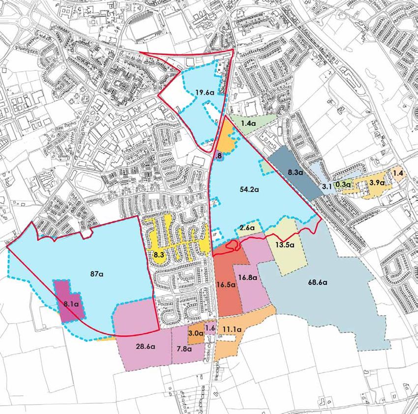
01: Strategic Masterplan Framework

  Introduction|

  Background                                                        Masterplanning                                                       Deliverability
  McAleer & Rushe is a privately-owned award-winning developer,     McAleer and Rushe commenced the master planning of                   As conveyed within each masterplan, McAleer and Rushe
  investor and contractor with over 50 years’ experience in         these landholdings in 2017. This process has involved full           have utilised their experience to roadmap the delivery of their
  the acquisition, design, development and construction of          engagement with fellow landowners, market analysis and               vision for these lands through phased development. McAleer
  commercial and residential property.                              considerable collaboration with Meath County Council. We             and Rushe have engaged with our neighbouring landowners
                                                                    believe this collaboration and input from MCC has resulted in        and established all the infrastructure, services and legal
  Headquartered in Cookstown, Northern Ireland with offices in      an aligned vision for the lands through several design iterations.   requirements for each phase. The commencement of both
  London, Belfast and Dublin, the company has delivered projects    We believe McAleer and Rushe’s reputation for delivery,              initial planned phases will unlock the entire MP8 and M13
  throughout the UK and Ireland. Some of these projects and         coupled with their long-term efforts and investment to date          landholdings and will represent the most appropriate sequential
  investments have been and are currently in Meath including        in this planning process are testament to our commitment to          development of the town for this area.
  the now matured housing development “Canterbrook” which is        deliver the overall vision.
  positioned adjacent to the landholdings that are the subject of                                                                        We foresee the quality and design of these initial residential
  the Commons Road Masterplan.                                      As aforementioned, we feel the timing is now right to progress       phases setting the benchmark for our wider masterplans-
                                                                    with this vision. This has been further enhanced by the recent       triggering interest and activity in the south side of Navan,
  Since completing Canterbrook, McAleer and Rushe have              grant of planning permission for the LDR1B road which will           demonstrating the calibre of development that can be delivered
  continued to invest in the southern area of Navan over a period   provide direct access from these lands to the M3 Motorway,           in this area.
  of time commencing in 2001 to their most recent acquisition       as well as the existing permission for LDR2, which will better
  in 2018, totalling an additional 37 acres. The additional 37      consolidate and connect the South/West area of Navan.                As part of the McAleer and Rushe acquisition in 2018, they
  acres were strategically acquired to finally consolidate their                                                                         have acquired approximately 20 acres of lands at MP6 in Navan
  landholding, enhancing McAleer and Rushe’s strategic                                                                                   Town Centre (NTC). These lands were acquired strategically
  importance to the southern side of Navan, bringing their total                                                                         in the context of McAleer and Rushe’s current holding.
  landholding to a position where they can now start to deliver                                                                          McAleer and Rushe envisage these lands incorporating
  on their long-term vision. In total McAleer and Rushe now hold                                                                         significant commercial use, primarily retail. We are currently
  approximately 160 acres of zoned land, set across over 3 main                                                                          advancing plans with a large food retailer, along with ancillary
  parcels.                                                                                                                               retailers which we believe will be of considerable benefit to
                                                                                                                                         our landholdings and NTC. We see development on both the
                                                                                                                                         northern and southern portions of this site to follow the initial
                                                                                                                                         phases on MP8 and MP13.

                                                                                                                                                   01 | Strategic Masterplan Framework | Lands at Trim Road Navan|   5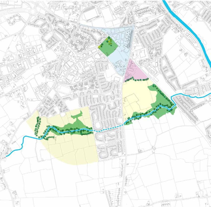
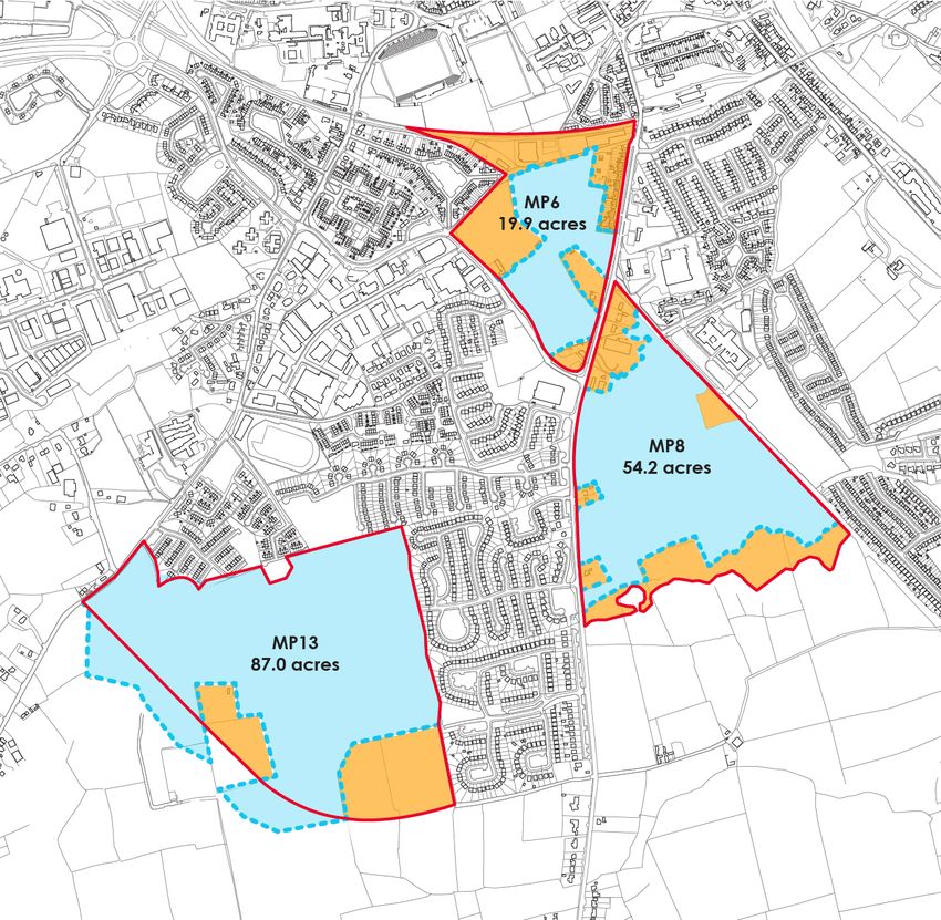
McAleer and Rushe Ownerships
                                                                     McAleer and Rushe land holdings comprise three distinct areas :

                                                                     1. 19.9Ha in the Town Centre/ MP6 area.

                                                                     2. 54.2Ha south-east of the town centre in the mixed use MP8 area

                                                                     3. 87Ha south-west of the town centre in future residential MP13 area.

                                                                        Legend

                                                                        1. McAleer & Rushe ownership

                                                                        2. Lands owned by others

                                                                        3. Masterplan Boundaries

6   01| Strategic Masterplan Framework | Lands at Trim Road Navan|
Ownerships versus Masterplan Areas
Of the McAleer & Rushe land holdings, two of the three areas
are subject to detailed masterplans. These correspond to
Meath County Council designations MP8 and MP13.

Proposed masterplans extend beyond ownership where
required to demonstrate comprehensive and coherent
development in line with MCC aspirations.

   Legend

   1. McAleer & Rushe

   2. Masterplan Boundary

   3. Meath County Council

   4. Meath VEC - lease to ESB

   5. MCC & formerly Vitgeson LTD

   6. Cusack Homes LTD

   7. Sion Development LTD

   8. Dundas LTD

   9. James Corolan

   10. Eamon Corley

   11. Davy Target Investments PLC

   12. Francis Harte

   13. Liam Quail & Francis Harte

   14. Liam (RIP) & Geraldine Quail

   15. James Feeney

   16. Lowcroft LTD

   17. ESSO Ireland LTD

   18. Other Ownership included in Masterplan

          01 | Strategic Masterplan Framework | Lands at Trim Road Navan|   7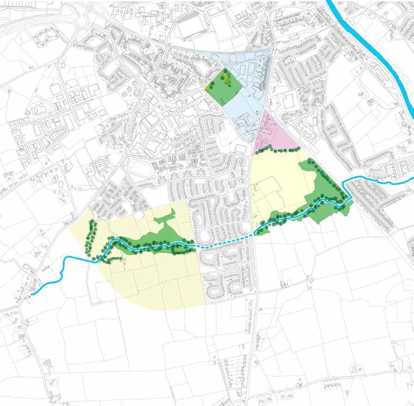
Planning Context |
Requirements and Objectives
Navan is the fifth largest town in Ireland with a population of
30,173 persons recorded in the Census 2016. Spatially, the
town is located in the Hinterland Areas of the Eastern and
Midland Region, outside of the Metropolitan area of Dublin City
and suburbs.
The National Planning Framework (NPF) directs significant
growth to the Hinterland Areas and states that 50% of overall
national growth is to be accommodated in areas outside the five
cities. Emphasis placed on renewing and developing existing
settlements to encourage compact and sustainable growth. To
support this vision, the NPF sets a target for at least 30% of new
housing in targeted settlements outside the five cities to occur
within their built-up areas.
As the County Town for Meath, Navan plays a strategic role in
the implementation of the NPF as described under the Regional
Spatial & Economic Strategy for the Eastern & Midland
Regional Assembly (RSES). Navan is listed as a Key Town with
the capacity to deliver sustainable economic and population
growth to complement Dublin and the Regional Growth Centres
of Athlone, Dundalk and Drogheda. It is recognised that
Navan has experienced unbalanced growth over the past two
decades and therefore the RSES supports key infrastructural
development and urban consolidation and regeneration to
release both employment and residential lands. Overall, the
RSES aims to develop Navan as growth driver for the region and
an attractive place to live, shop, visit, and do business.
Navan sits at the top tier of the County Meath Urban Settlement
Hierarchy and is designated as a Large Growth Town I under the
Meath County Development Plan 2013-2019 with a population
Target of up to 50,000 persons. Navan is also a Primary Economic
Growth Town that acts as an anchor for regional enterprise and
investment. Central to the growth of Navan is the achievement
of critical mass necessary to attract industry and services and
support infrastructural investment so that the town may be self-
sufficient and develop in a sustainable and integrated manner.
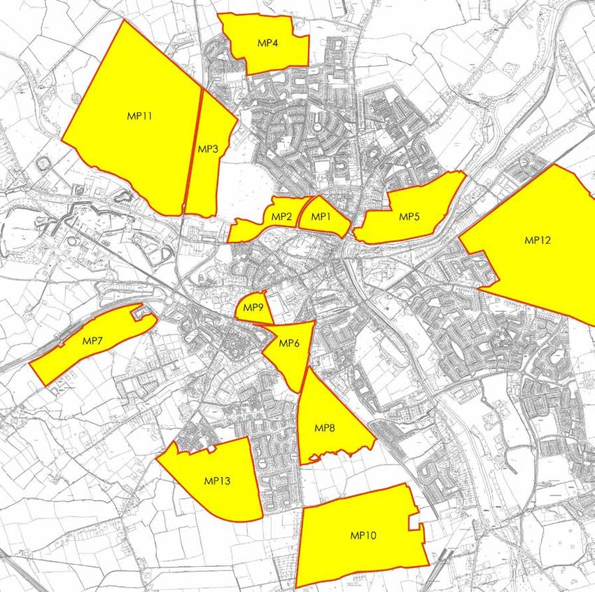
The Navan Development Plan 2009-2015, designates thirteen
masterplan areas each with strategic development objectives
(shown left). McAleer & Rushe control strategic landbanks
within masterplan areas MP6, MP8 and MP13 identified above.
8 01| Strategic Masterplan Framework | Lands at Trim Road Navan|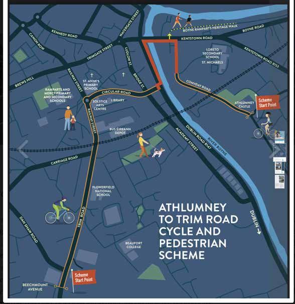
Land Use Zoning
      Map No.1: Navan Development Plan 2009-2015, Incorporating
      Variation No.2 made on July 19th 2017
      Legend

      A1. Existing Residential

      A2. New Residential

      B1. Commercial/Town or Village Centre

      B2. Retail Warehouse Park

      C1. Mixed Use

      E1. Strategic Employment Zones (High Technology Uses)

      E2. General Enterprise & Employment

      E1/E2. Strategic Employment Zones (General Enterprise & Employment)

      F1. Open Spaces

      G1. Community Infrastructure

      H1. High Amenity

      R1. Rail Corridor

      Interface with Detailed Design of Navan Rail Line Phase 3

      WL. White Lands

      SPECIFIC OBJECTIVES

      Development Plan Boundary

      Masterplan Boundary

      Residential Phase 2 (Post 2019)

      Interface with Flood Zones

      Multiple Residential Development Granted Planning

N.C   Neighbourhood Centre

SDZ   Phasing as per Approved SDZ Scheme

      Phase 1 Road Objectives

      Phase 2 Road Objectives
             01 | Strategic Masterplan Framework | Lands at Trim Road Navan|   9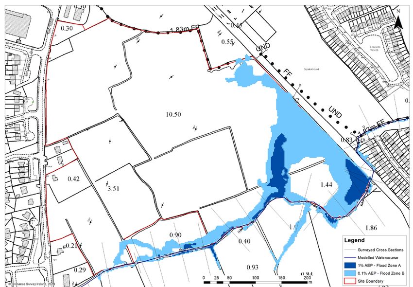
Masterplan Area Objectives
MP 6: MP 8: MP 13:
• ‘Lands in the centre of Navan which represent the expansion • ‘Lands at the Trim Road which are zoned for mixed use • ‘(Formerly FP3) these lands are situated between the Trim
of the town centre in Navan’. development’. Road and the Commons Road and are zoned for a mix of
uses, primarily residential’.
• Zoned ‘B1’ Commercial/Town or Village Centre’ and FI
‘Open Space. • Zoned C1 ‘Mixed Use’ and FI ‘Open Space’ • Zoned Objective A2 New Residential with two areas for G1
Community Infrastructure and a Neighbourhood Centre
Accommodates: Accommodates: Designation
• lands reserved for the railway line extension; Accommodates:
• roads objective to connect the Dublin Road to the Trim
• land reservation for the development of a public transport Road; • 300 no. units in the period 2013 to 2019;
interchange providing a central rail station serving the Navan-
Dublin rail line; • residential Phase 2 designation for development Post- • Neighbourhood Centre with employment generating uses,
2019; Community Centre/Health Centre, a primary school site,
• civic plaza; childcare facilities and local shops and services;
• pedestrian and cycle linkages from the site to the Town • flood risk zone that traverses the site along the path of the
• access and views from adjoining residential lands and the
Centre and Brews Hill areas; Swan River;
LDR2(a) local distributor road; and
• statement buildings of innovative high quality architectural • 300 no. residential units within the life of the CDP on a • public open spaces facilitating the integration of the Swan
design; phased basis that maintains the alignment of the River.
LDR1(a);
• a community building;
• residential uses; and • a large public open space;
• entertainment and cultural uses. • childcare facilities;
• medical Centre;
• community/Resource Centre; with
• supporting comprehensive landscaping scheme, public
lighting and footpaths, high quality design and layout, and
necessary infrastructure for vehicles, pedestrians, cyclists
and people with disabilities.
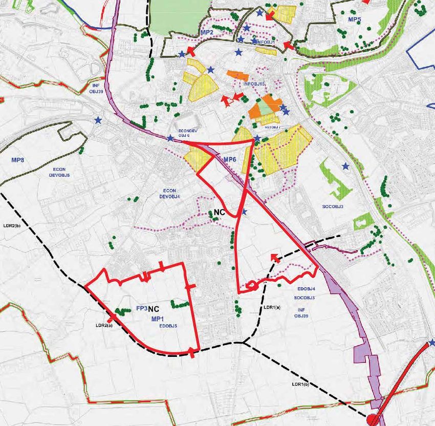
10 01| Strategic Masterplan Framework | Lands at Trim Road Navan|navan town centre context|
Relationship to Navan Town Centre
M&R land holdings are illustrated here in the context
of the Key Development Objectives of the Town Centre.
Of note are:
• the MP6 interface with detailed design of the Rail
Route;
• the MP8 gateway site outside of the M&R ownership
but within the masterplan area;
• LDA alignments through MP8 and MP13; and
• Amenity Pedestrian way along Swan River in MP8.
Legend
MP6 1. Town Council Administrative Boundary
2. Navan Development Plan Boundary
3. Framework Plan Boundary, Map Ref. FP
4.Masterplan Boundary, Map Ref. MP
5. Local Distributor Road Corridors (Diagrammatic Only)
MP8 6. Proposed Access Points, Map Ref. AP
7. Possible Access Road Linking Railway Street with Brews Hill
8. Pedestrian Access/Amenity Walkways
9. Rail Route Reservation Corridor (R1)
10. Interface with Detailed Design of Navan Rail Line Phase 2
MP13 11. Proposed Civic Space / Environmental Improvements
12. Proposed Town Park
13. Stand of Trees to be Preserved
14. Individual Trees to be Preserved
15. Housing Protection Areas (HPPOL1)
NC 16. Location of Neighbourhood Centre Map Ref. NC
17. Location of Gateway Site
18. Access to National Roads Exceptional Circumstances
Map No.2: Navan Development Plan 2009-2015, Incorporating Variation No.1
made on May 19th 2014- Development Objectives
01 | Strategic Masterplan Framework | Lands at Trim Road Navan| 11Relationship to Navan Core Strategy
M&R land holdings are illustrated here in the context
of the Core Strategy Map for the Town Centre. Of note
are:
• improved connectivity between MP6 Navan Central
Station area and the Town Centre Public Transport
Priority Area;
• Cycle and Pedestrian Network improvements linking
MP6, MP8 & MP13;
• Open Space Networks in MP8 & MP13; and
• The Neighbourhood Centre in MP13.
• the MP8 gateway site outside of the M&R ownership
but within the masterplan area;
• LDR alignments through MP8 and MP13; and
• Amenity Pedestrian way along Swan River in MP8.
Legend
1. Town Centre 15. Johnstown Cycle Network
2. Town Centre Expansion 16. Town Centre Public Transport Prior-
3. Employment Zones ity
MP6 4.Proposed Employment Zone 17. Improve Connectivity
5. New Communities 18. R147 Public Transport Corridor
6. Hospital 19. Regional Roads
MP8
7. Proposed Regional Hospital Site 20. National Roads
8. Neighbourhood Centre 21. Local Roads
MP13
9. Retail Warehousing 22. Motorway
10. Boyne and Blackwater Rivers 23. Proposed Local Distributor Roads
11. Open Space Network BUS 24. Town Boundary
12. Rail Transportation Corridor 25. Bus Interchange
13. Proposed Rail Stations 26. Masterplan Boundaries
14. Cycle/Pedestrian Network & Improvements
12 01| Strategic Masterplan Framework | Lands at Trim Road Navan|strategic urban design vision|
A ‘Green-Grid’ for Pedestrians
The Swan River watercourse bisects both the MP8 and MP13
masterplan areas. This offers the opportunity across the two
individual masterplans to deliver a strategically scaled linear
greenway along its banks that connects back to the existing
north to south connection of both the Trim Road and the rail-line
to the west. Provision of the greenway and attendant large scale
open spaces is consistent with Core Strategy requirements for
each landbank.
The rail line reserve is maintained as the eastern boundary of
MP8 and bisecting MP6. With the Swan River as a green spine
in the east-west direction, this reserve acts as the spine in the
north-south direction. With these primary linkages in place
at a strategic level, each of the individual masterplans then
develops secondary network of pedestrian and cycle linkages
to form a ‘green grid’ across the lands that in turn connects to
the townwide cycle infrastructure such as the Athlumley to Trim
Road cycle and pedestrian scheme.
Legend
1. Zoned Commercial Town Centre (MP6)
2. Proposed Commercial Node (MP8)
3. Residential
4. Zoned Open Spaces
5. Green Pedestrian & Cycle Links
6. Neighbourhood Centre
01 | Strategic Masterplan Framework | Lands at Trim Road Navan| 13Connecting the Town Centre
T.C.
The green-grid is established to take advantage of the fact that the
MP8 lands at Trim Road fall within a 10min walking distance of the
town centre, whether by means of the rail-line or the Trim Road.
When these routes are connected to a greenway along the Swan River
watercourse, the MP13 Neighbourhood Centre area is brought within
a 20mins walking distance to the town centre, in a pleasant people-
centric environment physically separated from busy car-oriented
T.I. routes.
5min
The western extremity of this green spine meets the Commons Roadat
c.30min walk from the town centre.
10min
30min
N.C.
20min
Legend
1. Zoned Commercial Town Centre
2. Proposed Commercial Node
3. Residential
4. Zoned Open Spaces
T.C 5. Town Centre
T.I 6. Transport Interchange
N.C 7. Neighbourhood Centre
14 01| Strategic Masterplan Framework | Lands at Trim Road Navan|Urban Street Network
The strategic vehicular movements within and between the
individual masterplan areas reflect the urban road network
emerging through the approval of various components of Meath
County Council’s local distrubutor road proposals.
Local access roads within the masterplan areas are planned to
be consistent with DMURS to ensure the highest possible levels
of permeability and connectivity, with the urban road network
ultimately underpinned by the green-grid and Swan River spine
as described previously.
Legend
1. River
D
2. Bus Stops
A
RO
3. Neighbourhood Centre
NS
MO
4. Trim Road
M
CO
5. Commons Road
6. LDR1 (A)
TRIM ROAD
7. LDR1 (B)
8. LDR2 (A)
9. LDR2 (B)
10. Local Access Roads
11. Transport Interchange
01 | Strategic Masterplan Framework | Lands at Trim Road Navan| 1502: Urban Design Framework for Lands at Trim Road Navan (MP8)
physical context|
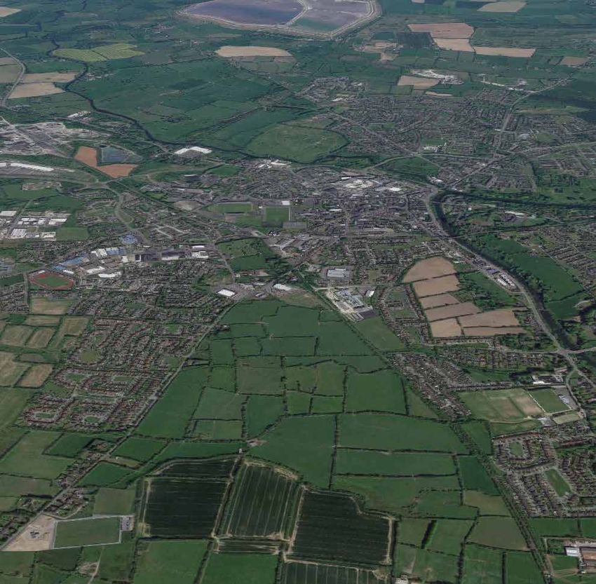
Site Characteristics
The main structuring elements of the lands are natural features
such as hedgerows, streams, trees and pedestrian routes.
There are no areas of Special Conservation status or subject to
any other statutory designation with regard to nature or wildlife.
With regard to the existing hedgerows, it is a general objective
of Meath County Council, and of the design team, to seek
preservation of existing hedgerows to define character areas
where possible.
12
The western boundary of the subject area comprises elements
of residential use and limited non-residential commercial use
5 6 with frontage to the Trim Road. Residential use is generally of
single-family dwelling scale and is piecemeal in fashion along
4 the frontage.
9 New development will have the opportunity to consolidate road
10 frontage similar to existing mature residential development
13 patterns at Balreask, Beechmount, and Canterbrook west of
3 the Trim Road.
MP8 Lands: 7
2 8
1 Trim Road
2 Canterbrook
3 Beechmount
4 Future Public Transport Interchange
13
5 Pairc Taillteann Stadium
6 Navan - Drogheda Rail Corridor
7 Limekiln
8 River Boyne and Swan River meeting point
9 Existing node of development
1
10 Former Greyhound Track
11 Navan-Dublin Rail Line
12 Town Centre
13
Schools
02 | Urban Design Framework | Lands at Trim Road Navan 17Pitch & Putt
Legend Site Landscape Features
1. Swan River Watercourse The eastern boundary comprises the embankment cutting of
the disused Dublin-Navan railway line. This amounts to the main
2. MP18 Site Boundary
element of built heritage within the subject lands and serves as
3. Existing Pedestrian Corridor along disused Railway Line a pedestrian route from the existing commercial development
Gaelscoil node at the northern apex of the lands to the south-east,
4. Zoned Open Spaces granting access to the newer residential development areas to
5. Strong Tree Belts
the east at Limekiln.
6. Trim Road Beaufort College The lands incorporate the Swan River water course which
bisects the subject area east to west and is surrounded by an
7. Sun Path extensive identified flooding area. South of this reservation, the
lands return to agricultural use and are mainly used for grazing.
Circle K
SuperValu
The western boundry presents extensive frontage to the Trim
Road. Pedestrian and cycle infrastructure will be provided along
this entire frontage consistent with the Navan Cycle network
and tying in with the Athlumley to Trim Road pedestrian and
cycle upgrade that terminates at Circle K. The necessary legal
interest has been acquired from MCC and Circle K to connect
this infrastructure.
Win
ter
Sum
So
l st
ic
me
e
r So
lstic
e
18 02 | Urban Design Framework | Lands at Trim Road Navanplanning context|
Land Use Zoning
Map No.1: Navan Development Plan 2009-2015, Incorporating
Variation No.2 made on July 19th 2017
Legend
A1. Existing Residential
A2. New Residential
B1. Commercial/Town or Village Centre
B2. Retail Warehouse Park
C1. Mixed Use
E1. SEZ- High Technology Uses
E2. General Enterprise & Employment
E1/E2. SEZ- General Enterprise & Employment
F1. Open Spaces
G1. Community Infrastructure
H1. High Amenity
R1. Rail Corridor
Interface with Design of Navan Rail Line Phase 3
WL. White Lands
SPECIFIC OBJECTIVES
Development Plan Boundary
Masterplan Boundary
Residential Phase 2 (Post 2019)
Interface with Flood Zones
Multiple Residential Development Granted Planning
N.C Neighbourhood Centre
SDZ Phasing as per Approved SDZ Scheme
Phase 1 Road Objectives
Phase 2 Road Objectives
02 | Urban Design Framework | Lands at Trim Road Navan 19Requirements and Objectives
The lands are zoned Objective C1 Mixed Use: ‘To provide for • The provision of a Medical Centre;
and facilitate mixed residential and business uses.’ C1 zones
encourage mixed use development. At least 30% of the area • The provision of a Community/Resource Centre;
will be dedicated for commercial (non-retail) development.
• A comprehensive landscaping scheme;
Settlement Strategy OBJ 19 requires the preparation of a
Masterplan (MP8) that incorporates the following: • Provision of adequate public lighting and footpaths
throughout the lands;
The provision of a maximum of 300 no. residential units within
the life of the Development Plan on a phased basis as follows: • High quality design, finish and layout, and;
• Phase I shall provide a maximum of 150 no. residential • Infrastructural requirements including access for vehicle,
units and shall provide for the provision of the extent of pedestrians, cyclists and people with disabilities, car
LDR 1 (a) contained within the Master Plan boundary. This parking and vehicle turning.
shall adhere to an agreed alignment as provided by the
The Development Plan states that it will be a requirement
Roads Authority for the provision of LDR 1 (a) in its entirety.
to seek financial contributions from all relevant benefiting
Development may proceed and be occupied in advance of
parties towards the cost of infrastructural improvements both
this section of LDR 1 (a) being completed subject to a traffic
inside and outside the area including Local Distributor Road
impact assessment indicating capacity in the local road
LDR 1 (a). This may include consideration of a Supplementary
network as required pursuant to INF OBJ 2 (c).
Development Contribution Scheme pursuant to Section 49 of
• Phase II may commence after a minimum of 80% of the the Planning & Development Act 2000-2014.
residential component of Phase I has been completed and
The Plan envisages that this landbank will be developed at
shall provide a maximum of 150 no. residential units. No
a density of 30 to 35 units per hectare. Having regard to the
residential development shall be occupied within Phase II
location of the site in a designated growth town, and emerging
until a connection has been secured by the Roads Authority
national policy, a density of in excess of 35 units per hectare is
working in collaboration with the landowners within Master
proposed by this Masterplan.
Plan 8 of a link road connecting the Trim Road with the
Dublin Road. It is envisaged that such a link will connect the The Masterplan will include a Phasing Plan, identifying the
alignment indicated on the development objectives map proposed Phasing Areas and the infrastructure to be delivered
with the permitted LIDL access road and other connections in each phase.
as considered appropriate.
• Design principles shall seek to ensure that majority of
commercial development adjoins the northern portion of
the site;
• Provision of a large area of public open space, which
may be included in the partial calculation of public open
space in certain circumstances within a given residential
development in MP 8;
• Childcare facilities;
20 02 | Urban Design Framework | Lands at Trim Road NavanDESIGN CONSIDERATIONS| SWAN RIVER WATERCOURSE Flood status
Swan River Watercourse
The Swan River Watercourse is one of two physical elements
of primary importance in the development of the urban design
framework.
As indicated previously, the river itself forms the spine of a
pedestrian connection between the Trim Road to the west and
the rail-corridor link to the east.
The wider flood area of the watercourse informs the open
space strategy across the masterplan, integrating with existing
hedgerow and field division pattererns to begin to form the
intended green-grid of people-focussed movements.
02 | Urban Design Framework | Lands at Trim Road Navan 21Flood Status of the Masterplan Lands
MP8 Extents
The Eastern CFRAM study for Navan identified 10, 100 and 1000
year flood extents on the Masterplan lands along the course of
the Swan River. The flood extents are identified on the diagram
opposite.
JBA Consulting Engineers was commissioned by Meath County
Council to undertake a SFRA of the proposed draft variation to
the Navan Development Plan 2009-2015. An objective of the
SFRA was to produce fluvial flood mapping for Navan Town and
its surrounding area. These flood zone maps were produced
from the results of hydraulic modelling and other flood data
sources available for the Navan area. The fluvial flood extent
map on the MP8 lands is presented on the following page. It
is noted that the modelled flood extent is very similar to the
Eastern CFRAM flood extent.
Eastern CFRAM Fluvial Flood Extent Mapping
22 02 | Urban Design Framework | Lands at Trim Road NavanThe flood extents modelled in both the Eastern CFRAM and JBA
SFRA have informed the zoning objectives on the MP8 lands.
MP8 Extents
A The boundaries of the lands Zoned Objective F, ‘Open Space’
are consistent with the identified Flood Zones A and B extents.
The Flood Zone A and B areas are within the Phases 3 & 4 area
of the MP8 Masterplan. A Site Specific Flood Risk Assesssment
shall be undertaken to identify the precise extents of Flood Zones
A and B on those areas prior to the making of any application
incorporating those areas or lands immediately adjoining.
2
1
4
3
A Phase A
1 Phase 1
2 Phase 2
Phase 3
Fluvial Flood Extent Mapping - JBA SFRA
3
4 Phase 4
02 | Urban Design Framework | Lands at Trim Road Navan 23DESIGN CONSIDERATIONS| LOCAL distributor road
Proposed Street Hierarchy
The second key design consideration is the planned Local
Distributor Road LDR1(A).
The Navan Development Plan states that the Phase 1
development on the MP8 Lands ‘shall provide for the provision
of the extent of LDR 1 (a) contained within the Master Plan
boundary’.
It is notable that the strategic transport context of the south
of Navan has changed considerably since the adoption of the
Navan Development Plan, as the Part 8 scheme for the LDR 1(b)
distributor road has been adopted by Meath County Council in
2019. The LDR 1(b) is to connect the Trim Road at a point south
of Balreask Manor with the M3 Navan Link Road between its
junction with M3 Junction 8 and its roundabout junction with
the R147. This road is strategic in function, and serves to
connect the MP8, MP10, and MP13 Masterplan Areas with the
M3 directly and onwards to the wider strategic road network.
With the LDR 1(b) in place, the LDR 1(a), which connects the
Trim Road with the Dublin Road at Springfield Glen, is no longer
strategic in function, serving instead as an internal link between
the south of Navan and the Johnstown area on the other side of
the Boyne. As such, the delivery of the LDR 1(b), rather than the
LDR 1(a), is key to the development of the phases of the MP8
Sum
following the first phase, while the delivery of the LDR 1(a) is
me
not necessary for the operation of the Phase 1 of the MP8 lands
and will occur at a later phase in the development of the overall
r So
masterplan.
lstic
e
DMURS has been referenced in setting out the masterplan,
with the design response summarised on Page 29 below.
Phase 1 Application drawings illustrate relevant road types in
more detail indicating their individual characteristics.
Legend
Trim Road
LDR 1(A)
North South Link Street
Local Access Street
24 02 | Urban Design Framework | Lands at Trim Road NavanLDR 1(a) Alignment as Approved MP8 Extents
02 | Urban Design Framework | Lands at Trim Road Navan 25urban design framework|
Urban Design Objectives
The urban design objectives for the emerging masterplan have
been developed to reflect not only Meath County Council’s
planning objectives, but also to demonstrate consistency with
the twelve assessment criteria for sustainable residential
communities set out in the DoEHLG Urban Design Manual*: CONT
EX
CONNEC
TIO INCLUSIVITY
T N
7. Layout:
S
1. Context:
The masterplan responds to both the strategic location of the The masterplan creates people friendly streets and spaces by
lands in proximate location to the south side of Navan and their legibly using a series of new public open spaces to connect the
landscape structure by providing for a connected, street based town centre to the Swan River watercourse, and the Trim Road
neighbourhood accessible by sustainable modes to the town to the Dublin-Navan railway cutting.
centre and established community,
8. Public Realm: VARIE
TY
EFFICIEN
CY
TINCTIVEN
DIS
2. Connections: ES
S
A safe, secure, and enjoyable public realm is created by the
The layout represents a landscape-led ‘ground up’ organisation supervision of new routes and spaces by adjacent residential
of the new neighbourhood structured by a clear hierarchy of development.
primary and secondary street networks designed with reference
to DMURS. 9. Adaptability:
3. Inclusivity: Residential and non-residential building typologies will be
future-proofed to offer high levels of flexibility to allow responsive LAYOUT PUBLIC REAL
M ADAPTABILIT
Y
The secondary street and ‘green and blue’ networks prioritise change of use.
access for all, with the public realm based on a concept of
pedestrian and cycle connectivity. 10. Privacy and Amenity:
4. Variety: The privacy amenity of existing adjacent dwellings is maintained
through the siting of new dwellings in back to back or gabling
The masterplan provides for a new residential community relationships to these dwellings.
IVACY & AMEN PARKING
DET
AILED DES
PR IG
comprised of a varied range of dwelling types along with IT
Y N
commercial (non-retail) uses in proximity to the town centre. 11. Parking:
5. Efficiency: Parking will be provided at grade in-curtilage or on-street
according to Meath County Council provisions and in line with
The masterplan makes efficient use of the land resource by national policy guidelines including the Apartment Guidelines
applying appropriate sustainable residential densities of 45 (2018).
dwelling units per hectare.
12. Detailed Design:
6. Distinctiveness:
Landscape design will be integral to the integration of natural
The layout creates a sense of place through the careful resources to the new patterns of development established by
consideration of wayfinding between the new spaces and the masterplan.
their wider context using existing green and blue networks of
* It is noted that criteria 8-12 cannot be demonstrated in detail
the watercourse and mature hedgerows and in a legible street at the masterplan scale and are demonstrated through the
hierarchy with built form of buildings used to demark important detailed application for Phase 1.
wayfinding points.
26 02 | Urban Design Framework | Lands at Trim Road NavanUrban Design Principles
The key design objectives for the emerging masterplan reflect
Meath County Council’s objectives as well as demonstrating
the twelve assessment criteria set out in the DoEHLG Urban
Design Manual:
1. Context:
The masterplan responds to both the strategic context (utilising
the location of the lands in proximate location to the south side
of Navan) and the local context (harnessing their existing their
landscape structure) to provide for a connected, street based
neighbourhood accessible by sustainable modes to the town
centre and established adjacent communities.
MP8
2. Connections:
The layout represents a landscape-led ‘ground up’ organisation
of the new neighbourhood structured by a clear hierarchy
of primary and secondary vehicular streets designed with
reference to DMURS and reflecting Meath County Council
1. Context 2. Connections current planning. Cycle connections are provided along the
main internal roads with connections to the external cycle
network.
3. Inclusivity:
The street hierarchy is reinforced by a secondary street network
that forms a green-grid of pedestrian focussed movement
based on existing landscape and ‘blue network’ site features.
The green-grid prioritises access for all, with the public realm
based on a concept of barrier-free access and the creation of
a porous edge between lands within the masterplan area and
the existing town by means of many and varied pedestrian
access points to the Trim Road and the greenway. Applications
under the masterplan will identify existing components of
these arrangements that need upgrading in order to meet the
masterplan aspirations.
4. Variety:
The masterplan provides for a new residential community
comprised of a varied range of dwelling types along with
commercial (non-retail) uses in proximity to the town centre.
Individual applications under the masterplan will detail specific
typologies and mixes to ensure that delivery over time is
3. Inclusivity 4. Variety responsive to Navan’s needs.
02 | Urban Design Framework | Lands at Trim Road Navan 275. Efficiency:
The masterplan makes efficient use of the land resource by
applying appropriate sustainable residential densities of 45
dwelling units per hectare.
6. Distinctiveness:
The layout creates a sense of place through the careful
consideration of wayfinding between the new spaces and their
wider context using existing green and blue networks of the
watercourse and mature hedgerows. Built form responds to the
street network to demark important wayfinding points through
architectural distinctiveness.
7. Layout:
The layout of the new residential community forms a link
between the intensity of use and compact urban form of Navan
Town Centre, and the urban fringe that will be demarked by
the completed series of LDR proposals. As such, the layout
is an urban infill town expansion proposal that handles the
5. Efficiency 6. Distinctiveness transition from town centre to urban edge. The masterplan
creates people friendly streets and spaces by legibly using a
series of new public open spaces to connect the town centre to
the Swan River watercourse, and the Trim Road to the Dublin-
Navan railway cutting.
8. Public Realm:
A safe, secure, and enjoyable public realm is created by the
supervision of new routes and spaces by adjacent residential
development. Detailed landscaping layouts set out the
public realm proposals for Phase 1 and their integration with
existing footways and street junctions, indicating where their
improvement is required to meet the masterplan aspirations of
inclusive access for all.
7. Layout 8. Public Realm
28 02 | Urban Design Framework | Lands at Trim Road Navan9. Adaptability:
Residential and non-residential building typologies will be
future-proofed to offer high levels of flexibility to allow responsive
change of use.
10. Privacy and Amenity:
The privacy amenity of existing adjacent dwellings is maintained
through the siting of new dwellings in back to back or gabling
relationships to these dwellings. New residential development
is carefully sited, oriented and designed in order to reconcile the
need for compact forms that provide supervision of the public
realm at relatively high densities with privacy of the dwelling
and associated open spaces. Minimum back to back separation
distances are maintained in line with national guidance.
11. Parking:
Parking will be provided at grade in-curtilage or on-street
according to Meath County Council provisions and in line with
national policy guidelines including the Apartment Guidelines
9. Adaptability 10. Privacy and Amenity (2018).
12. Detailed Design:
Detailed designs for both architectural and landscape Phase
1 proposals form the substance of the current application
and architectural design statement. Landscape design will
be integral to the integration of natural resources to the new
patterns of development established by the masterplan.
11. Parking 12. Detailed Design
02 | Urban Design Framework | Lands at Trim Road Navan 29proposed masterplan|
Emerging Masterplan
The Phase 01 Application lands are based on key parameters of
the wider proposed masterplan illustrated here.
Connections
The masterplan represents a landscape-led ‘ground up’
organisation of the new neighbourhood structured by a clear
hierarchy of primary and secondary street networks designed
with reference to DMURS (summarised separately below). Cul-
de-sacs are minimized in favour of increased connective loops
around access roads that connect to the link road in several
locations, and provide new access points to the Trim Road.
These are further supplemented by non vehicular connections.
Cycling facilities are provided along LDR 1(a) and the North
South Link Street, which both connect to the proposed cycle
facilities along the Trim Rd which run along the western edge
of the site.
Variety
Legend
The masterplan provides for a new residential community
1. Masterplan Boundary comprised of a varied range of dwelling types along with
2. Phase 1 Boundary
commercial (non-retail) uses in proximity to the town centre. The
Phase 1 scheme is the first component of that new residential
3. North South Link Street community and features7 no. dwelling types to encourage a
diverse community and build on the emerging neighbourhood
4. LDR 1(a)
centre at Trim Rd. In time, the overall masterplan will deliver
5.Local Access Street further variety in built form and typology.
6. Green Link to Trim Road Inclusivity
7. Vehicular Link to Trim Road The secondary street and ‘green and blue’ networks prioritise
access for all, with the public realm based on a concept of
8. Green Link to Rail Reserve
pedestrian and cycle connectivity. The Phase 1 development
9. Internal Green Link begins this network, featuring vehicular and non-vehicular
connections to the Trim Road.
10. Key Building
Public Realm
11. Open Space
A safe, secure, and enjoyable public realm is created by the
12. Swan River
supervision of new routes and spaces by adjacent residential
development. This is particularly pronounced in later Phases
where supervision of larger scale open spaces is required.
Within Phase 1, the supplemental landscape booklet provides
detail of the public realm design. The hedgerows are to be
retained where possible, by engaging with these field patterns
the proposed layout will create a sense of place, and develop a
structured public realm while respecting the existing fabric of
the area. Footpath upgrades along the full frontage of the site as
30 02 | Urban Design Framework | Lands at Trim Road Navan detailed in landscape submission will continue north past the
filling station to connect with the existing pedestrian footpath.DMURS Summary
The movement strategy across the masterplan lands is designed
according to prior comments from Meath County Council and
DMURS.
Vehicular cul-de-sacs have been minimized across all phases.
The resultant permeability will ensure that vehicular traffic is not
channelled so higher speeds and reversing manoeuvers are avoided.
To aid this permeability, increased connectivity has been designed
both with regards to the Trim Road and the North South Access
Street. These will have the additional benefit of calming traffic on the
North South Link Street.
Three vehicular connections are provided to the Trim Road- two to
internal Local Access Streets and one to the North South Link Street.
These are reinforced by five further pedestrian and cycle only links to
the Trim Road.
The North South Link Street is designed with frequent accesses to
adjacent residential areas, these access points approximately every
Legend 80 metres. These are offset on either side of the road, so that there
is a series of T-junctions rather than crossroads. Seven vehicular
1. Masterplan Boundary
connections are provided to the North South Link Street from Local
2. Phase 1 Boundary Access Streets: three each to eastern and western sides of the street.
3. North South Link Street Traffic calming measures such as raised tables are intended
throughout the local street network rather than preventing vehicular
4. LDR 1(a)
movements outright.
5.Local Access Street
Comprehensive pedestrian and cycle permeability is provided by
6. Green Link to Trim Road means of the secondary green grid described previously.
7. Vehicular Link to Trim Road Individual street designs and character are more fully demonstrated
within the detail drawings but DMURS compliance includes:
8. Green Link to Rail Reserve
9. Internal Green Link
• The North South Link Street has only parallel parking in a series of
bays and a road carriageway 6.5m wide, with 2m wide cycle lanes
10. Key Building on either side. It is designed to be relatively direct – while it curves
around the residential area to make the best use of land, this is a
11. Open Space
gentle transition rather than a 90 degree turn. There is potential
12. Swan River for some commercial use along the street as well.
• Local Access Streets (including Phase 1 access across from
Balreask Village) are designed without dedicated cycle facilities,
although use will be made of of traffic calming features such as
chicanes and raised tables to reduce its attractiveness for through
traffic.
02 | Urban Design Framework | Lands at Trim Road Navan 31Proposed Masterplan Phasing
The proposed phasing strategy decouples the development of
the town centre mixed use at the northern apex of the lands
from the delivery of a coherent residential neighbourhood to
the South.
Phase One develops the key vehicular entrances to the site from
the Trim Road, via the established Northern Link Street on the
northern part of the site, and from the Trim Road further south,
and two of the pedestrian/ cycle connections that will establish
the green grid. It also develops one of the key buildings to the
Trim Road frontage to establish identity.
Phase A will establish a predominately commercial use area
in close proximity to the town centre, as well as significant
elements of the green grid linking to Trim Road and the Rail
Reserve and connections to the North South Link Street. The
A
integration of the North South Link Street with the Local Access
Street network will allow development of Phase A without
dependency on other residentially oriented mixed use Phases.
Phase Two extended the community to the east, extending the
public open space established in the pilot scheme and creating
a second public space as well as an interface with the flood
area of the Swan River Watercourse.
2
1 Phases 3 & 4 complete the neighbourhood on either side of the
LDR 1(a) and formalise the Swan River Watercourse greenway
in line with the strategic aims of the urban design framework
4 The North South Link Street will be provided in Phases 1 and
2. Phase 1 includes an extension of the existing Link Street
provided by the Lidl access road from the Trim Road into the
Phase A commercial area to facilitate development on those
3 lands, and to facilitate pedestrian and cyclist connectivity
northward from Phase 1 toward the town centre. The balance
of the Link Street, linking the Phase 1 element to the LDR1(a)
will be provided in Phase 2.
A Phase A
1 Phase 1
2 Phase 2
3 Phase 3
4 Phase 4
32 02 | Urban Design Framework | Lands at Trim Road NavanABP Opinion Response
The proposed masterplan and attendant Phase One application
address the design matters raised in ABP Opinion 306556-20 as
issued to the applicant. These can be summarised as follows:
• Densities within the Phase 1 application and wider
masterplan lands have been revised upward to a baseline
of 45d/Ha in consideration of the proximity of the subject
lands to the potential rail station and connectivity to the
town centre.
• The Phase 1 application area and the wider masterplan
area have been reconsidered to create higher levels of
integration between the Local Access Street network
of the new community and both the Trim Road and the
proposed North South Link Street. Building orientations
within the development respond to the increased levels
of permeability to ensure overlooking of the public realm,
while typologies within Phase 1 and later phases have
been revised to create defined urban edges. The Trim Road
frontage in particular has been revised in this regard, with a
more positive contribution made to the streetscape.
• Primary and secondary movement networks have been
significantly revised in line with DMURS as demonstrated in
this document, in particular with regard to the establishment
of a clear street hierarchy, the provision of an additional
vehicular and active modes access to the North-South Link
Street and the reduction of vehicular cul-de-sacs.
• Prior to the change in the strategic function of the LDR1(a)
the DMURS street hierarchy included an East-West Link
Street connecting Trim Road with the LDR1(a). The DMURS
street hierarchy was reviewed having regard to the change in
status of the LDR1(a) and it was agreed with Meath County
Council that a North-South aligned Link Street would be
more appropriate for the MP8 lands than an East West Link
Street. The DMURS street hierarchy has been amended as
appropriate, as illustrated on Page 29 above.
• The North South Link Street will be provided in Phases 1
and 2. Phase 1 includes an extension of the existing Link
Street provided by the Lidl access road from the Trim Road
into the Phase A commercial area to facilitate development
on those lands, and to facilitate pedestrian and cyclist
connectivity northward from Phase 1 toward the town
centre. The balance of the Link Street, linking the Phase 1
element to the LDR1(a) will be provided in Phase 2.
02 | Urban Design Framework | Lands at Trim Road Navan 33Appendix: ABP Opinion 206556-20
should be had to need to develop at a sufficiently high density to provide for an
                                             Case Reference:
                                                                                               acceptable efficiency in serviceable land usage given the proximity of the site to
                                             ABP-306556-20                                     Navan town centre, with its established social and community services and
                                                                                               potential rail station. The further consideration of this issue may require an
                                                                                               amendment to the documents and/or design proposal submitted relating to
                                                                                               density and layout of the proposed development.

                                                                                            2. Development Strategy, Masterplan Requirement and Layout
   Planning and Development (Housing) and Residential Tenancies Act 2016
                                                                                               Further consideration of the documents as they relate to the Meath County
                 Notice of Pre-Application Consultation Opinion                                Development Plan requirement for a Masterplan to be agreed with the planning
                                                                                               authority in advance of any application. Further consideration/justification of the
                                                                                               documents as they relate to the layout of the proposed development particularly
Proposed Development: 126 no. residential units (80 no. houses and 46 no.                      in relation to the 12 criteria set out in the Urban Design Manual which
apartments), childcare facility and associated site works.                                     accompanies the above-mentioned Guidelines and the Design Manual for Urban
Trim Road, Balreask Old, Navan, Co. Meath.                                                     Roads and Streets. The matters of arrangement and hierarchy of streets; the
                                                                                               creation of a defined urban edge along the new link road; connectivity with
An Bord Pleanála has considered the issues raised in the pre-application                       adjoining lands; provision of quality, usable open space and the creation of
consultation process and, having regard to the consultation meeting and the                    character areas within a high-quality scheme should be given further
submission of the planning authority, is of the opinion that the documents submitted           consideration. Two-metre-high walls facing the proposed access roadway,
with the request to enter into consultations require further consideration and                 perpendicular car parking along the main link street, oversized turning bays and
amendment to constitute a reasonable basis for an application for strategic housing            long cul de sac should be minimised (or eliminated). Residential units set back
development.                                                                                   from and siding onto the Trim Road should be further considered, or design
                                                                                               rationale justified at application stage should this layout be maintained. The
An Bord Pleanála considers that the following issues need to be addressed in the
                                                                                               development should provide for a positive contribution to the public realm along
documents submitted that could result in them constituting a reasonable basis for an
                                                                                               the Trim Road frontage and the new proposed link road or design rationale
application for strategic housing development.
                                                                                               justified at application stage should the current proposals for the interface along
                                                                                               the Trim Road and link road be maintained. In addition, further
1. Density                                                                                     consideration/justification of the documents as they relate to the proposed
    Further consideration/justification of the documents as they relate to the density         housing mix, having regard to the proportion of two and three bed units within the
    in the proposed development. This consideration and justification should have              overall proposed scheme. The further consideration of these issues may require
    regard to, inter alia, the minimum densities provided for in the ‘Guidelines for           an amendment to the documents and/or design proposals submitted
    Planning Authorities on Sustainable Residential Development in Urban Areas’
    (May 2009) in relation to such edge of centre/ Greenfield sites. Particular regard

ABP-306556-20              Pre-Application Consultation Opinion               Page 1 of 6   ABP-306556-20             Pre-Application Consultation Opinion                      Page 2 of 6

                                                                                                                                  02 | Urban Design Framework | Lands at Trim Road Navan      35
3. Site Access and Roads Layout
tandem with a Flood Risk Assessment specifically relating to appropriate flood
Further consideration of the documents as they relate to vehicular, pedestrian risk assessment that demonstrates the development proposed will not increase
and cycle access, the desire line connectivity with Navan town to the north west flood risk elsewhere and, if practicable, will reduce overall flood risk. A Flood
of the site, the main link street access and its connection with the LDR1A Risk Assessment should be prepared in accordance with ‘The Planning System
distributor road proposed, future connection with the southern and eastern and Flood Risk Management’ (including the associated ‘Technical Appendices’).
portion of the MP8 lands and the creche access road. This consideration and Further consideration of these issues may require an amendment to the
justification should have regard to the County Development Pan requirement for documents and/or design proposals submitted.
a Masterplan for the overall MP8 lands and DMURS. The layout should prioritise
pedestrian and cycle access in compliance with DMURS. The revised strategy
should clearly demonstrate that regard was had to the 12 criteria as contained in Furthermore, Pursuant to article 285(5)(b) of the Planning and Development
the ‘Urban Design Manual – A best practice guide’ that accompanies the (Strategic Housing Development) Regulations 2017, the prospective applicant is
‘Guidelines for Planning Authorities on Sustainable Residential Development in hereby notified that, in addition to the requirements as specified in articles 297 and
Urban Areas’ (May 2009).The further consideration of this issue may require 298 of the Planning and Development (Strategic Housing Development) Regulations
amendments to the documents and/or design proposals submitted. 2017, the following specific information should be submitted with any application for
permission:
4. Infrastructure 1. Cross sections and other drawings, as necessary, at an appropriate scale, which
Further consideration/clarification of the documents as they relate to wastewater detail the interface between the proposed development with the Trim Road to the
infrastructure constraints in the network serving the proposed development. In west and the proposed development with the new link road/street and its
particular, the need to satisfy all issues, consent processes and 3rd Party connection with Roads Objective LDR1A to the south and east.
consents as raised in Irish Water submission dated 10/03/20.
2. A detailed phasing plan for the proposed development.
The documentation at application stage should clearly indicate the proposals to
address the constraints relative to the construction and completion of the 3. Ecological Survey of existing trees and hedgerows which clearly identifies all
proposed development have been fully agreed with Irish Water. (The trees/hedgerows proposed for removal.
prospective applicant may wish to satisfy themselves that an application is not 4. A detailed Habitat survey and Bat survey, with survey work carried out at
premature having regard to any infrastructure upgrades and third-party consents optimum time for such species / habitat.
which may be required).
5. Construction and Demolition Waste Management Plan
5. Surface Water Management and Flood Risk Assessment 6. A report that specifically addresses the proposed building materials and finishes
Further consideration of the documents as they relate to surface water and the requirement to provide high quality and sustainable finishes and details.
management for the site. This further consideration should have regard to the
requirements of the Drainage Division as indicated in their report dated 3rd
March 2020. Any surface water management proposals should be considered in
ABP-306556-20 Pre-Application Consultation Opinion Page 3 of 6
ABP-306556-20 Pre-Application Consultation Opinion Page 4 of 6
36 02 | Urban Design Framework | Lands at Trim Road NavanAlso, pursuant to article 285(5)(a) of the Planning and Development (Strategic
Housing Development) Regulations 2017, the prospective applicant is informed that
the following authorities should be notified in the event of the making of an
application arising from this notification in accordance with section 8(1)(b) of the
Planning and Development (Housing) and Residential Tenancies Act 2016:
1. Irish Water
2. Department of Culture Heritage and the Gaeltacht
3. National Parks and Wildlife
4. Inland Fisheries Ireland
5. Transport Infrastructure Ireland
6. An Taisce
7. Heritage Council
PLEASE NOTE:
Under section 6(9) of the Planning and Development (Housing) and Residential
Tenancies Act 2016, neither the holding of a consultation under section 6, nor the
forming of an opinion under that section, shall prejudice the performance by the
Board, or the planning authority or authorities in whose area the proposed strategic
housing development would be situated, of any other of their respective functions
under the Planning and Development Acts 2000 to 2016 or any other enactment and
cannot be relied upon in the formal planning process or in legal proceedings.
_________________________
Tom Rabbette
Assistant Director of Planning
May, 2020
ABP-306556-20 Pre-Application Consultation Opinion Page 6 of 6
ABP-306556-20 Pre-Application Consultation Opinion Page 5 of 6
02 | Urban Design Framework | Lands at Trim Road Navan 37You can also read