Merton Residents' Transport Group (MRTG) response to Merton Local Plan Consultation 2a
←
→
Page content transcription
If your browser does not render page correctly, please read the page content below
Paul McGarry
Head of Future Merton
London Borough of Merton
Crown House, Morden
SM4 5DX
                                                                                         30 January 2021
Dear Paul,

    Merton Residents’ Transport Group (MRTG) response to
              Merton Local Plan Consultation 2a
Introduction to MRTG
Merton Residents’ Transport Group (MRTG) was initially established to support the development of
emergency transport measures in Merton in response to the need for increased space for cycling and
walking as a result of COVID-19. It is a nonpartisan organisation whose members comprise local
residents, community organisations, and transport professionals.

The Group decided in October 2020 to extend its work until at least April 2021, both to support the
consultation on COVID-19 measures, as well as to contribute to the longer term thinking about active
travel in Merton.

The Group’s priority goals are to establish:
   ● Low Traffic Neighbourhood in every community where this is appropriate
   ● A joined-up network of safe, direct walking and cycling routes
   ● Traffic-free school streets at school run hours
   ● Pedestrian Friendly high streets to boost local business
   ● 20mph speed limit as default (already implemented but further enforcement / education required)

This letter sets out our response to Merton’s Stage 2a Draft Local Plan, commenting solely on portions of
the Draft Local Plan that are related to our Group’s priority goals.

Key comments to consultation
We appreciate the effort taken by officers to conduct this consultation despite the challenges presented
by COVID-19. We have outlined detailed comments in the below appendices, however the key themes to
our comments are is as follows:

Set clear ambitions for 2030: The Local Plan is expected to have a lifespan of 10+ years; the plan as
currently written feels near-term and “present-forward”, rather than envisioning the needs of the borough
and its residents in 2030 and what needs to be done over the next ten years in order to achieve this. In
particular, the Local Plan lacks detail on how Merton will create people-friendly neighbourhoods, and
reduce reliance on motor vehicles, both of which are essential to tackle the climate emergency.

Most of Merton’s roads are currently designed for and dominated by motor traffic. Overall the document
seems to skirt around the need to reduce motor traffic to make Merton more pleasant - to create a
borough people want to live, work, shop, eat out, spend time and visit. Streets make up around 80%
of public space in urban areas; given their extent, the way they are designed has a profound impact.

                                                    1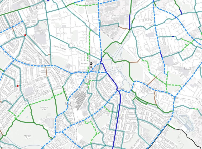
Good low traffic road design can enhance the quality of people’s lives, reconnect communities and make
an area more desirable to live in.

Define strategic active travel network: Increasing levels of cycling and walking is essential if we are to
tackle the climate emergency. We support the Local Plan’s recognition of the health benefits of active
travel, ambitions to support and promote active travel, and prioritisation of pedestrians and people cycling
within the public realm. However the Local Plan does not set out a sufficiently clear ambition for a
strategic walking and cycle network; whilst we support many of the initiatives described within the plan, in
aggregate they only set out a near-term vision and do not provide a long-term ambition to be delivered
over the duration of the plan. Merton needs to develop a clear vision of the integrated network it will build
across the borough, so that it can grow the number of residents who live within close proximity to cycle
infrastructure, and so that residents have a large number of journey opportunities provided by that
infrastructure. The appendices that follow include a proposal for a strategic, integrated cycle
network, and we have provided detailed commentary on the specific initiatives included within the Local
Plan documentation.

Build quality cycle and walking infrastructure: The Local Plan does not make clear what “good” looks
like. Future cycle and pedestrian infrastructure delivered either by developers or by Merton needs to meet
relevant DfT standards, most notably LTN 1/20 and Manual for Streets 3 (expected January 2022).
Specifically:
     ● Shared use paths should be avoided as these create conflict between pedestrians and people
         cycling, creating suboptimal experience, and in particular create difficulties for those who are
         visually impaired; where shared use paths are unavoidable, they should meet DfT guidelines on
         minimum width (3m for low-use, 4.5m for high-use)
     ● Gravel surfaces should be avoided, with smooth all-weather surfaces used instead, enabling year
         round usage and improving accessibility
     ● “Chicanes” or other barriers should not be used and should be removed from existing locations
         within the borough, as these impede accessibility
     ● Design of cycle routes should ensure that they offer a direct route, and there is no / limited time
         penalty in using the cycle route vs cycling in the carriageway, to ensure adoption; common ‘time
         penalties’ encountered include having to yield at each side road, having to cross the carriageway
         to use a short stretch of bi-directional track, or having to dismount

Ensure developments deliver on active travel: We welcome the inclusion of requirements for cycle
storage and facilities within new development, however the current draft of the Local Plan does not fully
reflect London Plan 2020 guidelines for vehicle and cycle parking provision; notably London Plan
guidelines for vehicle parking should be considered absolute maximums, with all residential, retail, hotel
and leisure developments in PTAL 5 or 6 areas to be “car free”. We additionally welcome opportunities
identified to use redevelopment of sites to improve permeability of major sites; specific comments on how
these could be further enhanced are outlined in the detailed appendix.

We have set out our detailed response to the consultation in the below appendices. We are happy to
discuss any of these points with officers as appropriate.

Yours faithfully,

Merton Residents’ Transport Group

                                                      2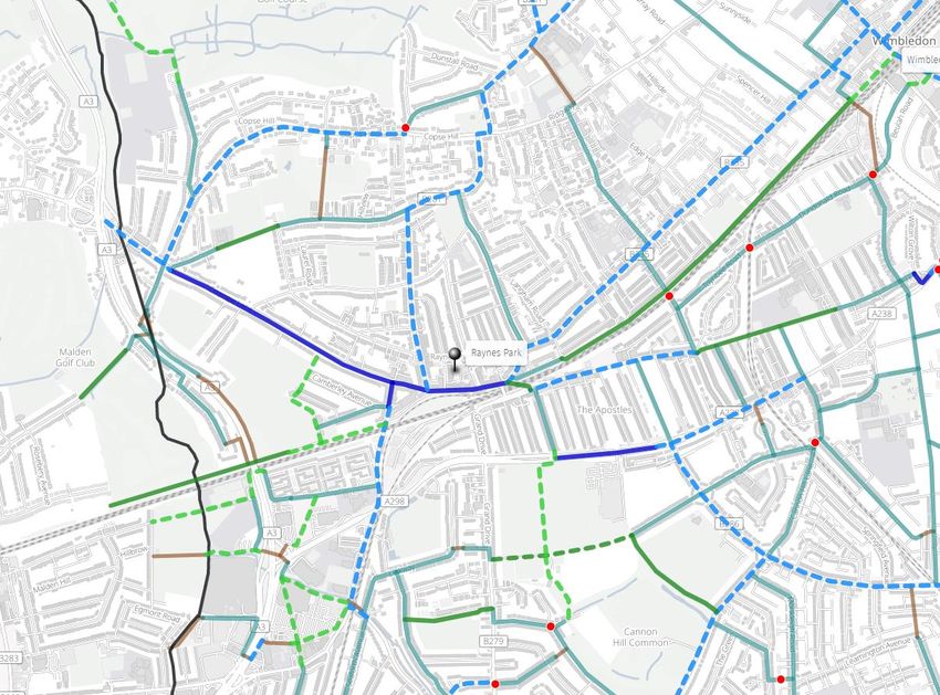
Appendix One: Detailed comments to consultation

Document                Comments

Good Growth             We support the Good Growth Strategy’s high level aims; however believe that it
Strategy                needs to:

                            -   Emphasise more clearly the need to disincentivise car ownership and
                                reduce the number of motor vehicles on Merton’s roads
                            -   Emphasise that for a shift towards walking and cycling to take place, it
                                is not just “encouragement” needed, but the construction of physical
                                infrastructure that make these options safer and more appealing; this
                                can particularly be enabled by an integrated cycle network across the
                                borough
                            -   Adopt the ‘standard’ 15 minute neighbourhood taxonomy, as opposed
                                to the “20 minute” neighbourhoods used

                        This strategy needs to be backed up by detailed proposals; we have provided
                        further perspectives on this in the relevant sections of the consultation
                        response.

Urban Development       In line with our comments on the “Good Growth Strategy” above, these
Objectives and Vision   objectives and vision need to:

                            -   Emphasise more clearly the need to disincentivise car ownership and
                                reduce the number of motor vehicles on Merton’s roads
                            -   Emphasise that for a shift towards walking and cycling to take place, it
                                is not just “encouragement” needed, but the construction of physical
                                infrastructure that make these options safer and more appealing
                            -   Adopt the ‘standard’ 15 minute neighbourhood taxonomy, as opposed
                                to the “20 minute” neighbourhoods used
                            -   Specifically list “deliver and integrated cycle network” as an objective
                                by 2036

Colliers Wood           To achieve the stated aim of helping to make Colliers Wood easier to navigate
                        for pedestrians and people cycling and also support and promote active travel:

                        Policy N3.1b should read "... making the environment more attractive to own
                        centre users, especially pedestrians and people cycling;”

                        Policy N3.1 g or h should explicitly mention that for development to be
                        supported it must support the development of a coherent cycling network in
                        Colliers Wood that is connected to the Borough-wide network.

                        N3.1g “Improving traffic flow” should not be a rationale to support
                        development, as this may induce demand for journeys by private vehicle and
                        consequently overall network demand; development should additionally be
                        supported where it improves connectivity by foot / cycle and where the
                        borough’s foot / cycle network is improved

                        No linkage is made to the Transport strategy or maps and how the proposals
                        contained within these will be managed or supported within Colliers Wood,
                        which include:

                                                   3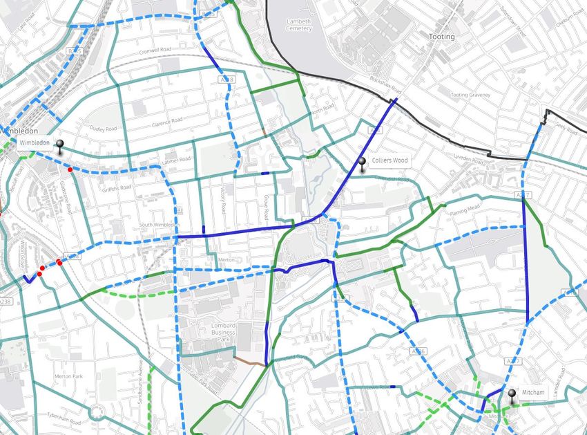
●   The Proposed Sutton Tramlink route Option 2 Colliers Wood to Sutton
              ●   The ‘Sustainable Transport Corridor’ from Colliers Wood to Mitcham’
                  shown on the ‘Walking and Cycling Map for Colliers Wood’
              ●   A ‘Cycle Hub’ (and how that will connect to the Wimbledon Cycle Hub)

          Specific feedback on site allocations:

          CW1: No specific comments.

          CW2: CW2 (Britannia Point south) should be required to connect to CW5
          (Priory Retail Park) and each other coherently through a joined up approach to
          public realm and walking and cycling provision.

          CW3: No specific comments.

          CW4: No specific comments.

          CW5: CW5 (Priory Retail Park) and CW2 (Britannia Point south) should be
          required to connect to and each other coherently through a joined up approach
          to public realm and walking and cycling provision.

          A general comment on Colliers Wood PTAL and Site Allocations:
          Colliers Wood is described as having 'excellent' PTAL in para 3.1.3, but there is
          then inconsistency in the scoring and descriptions within the site allocations:
              ● CW1 - has PTAL of 6a Excellent (Across the road from the tube)
              ● CW2 (Britannia Point) - PTAL of 5 'very good'
              ● CW3 community centre - PTAL of '5' but is described as only 'good'
              ● CW4 (station and parade) - PTAL of 5 and 'very good', although it
                   seems questionable that a site containing the tube station has a lower
                   PTAL than CW1
              ● CW5 (Priory retail park) - PTAL of 5 and 'very good'

Mitcham   Policy N3.2c and N3.2l provide weak guidance on active travel routes. These
          need to be significantly strengthened. Specifically, they do not cover the need
          for a network of pedestrian and cycle routes as opposed to isolated
          improvements. The goal of a network needs to be clearly expressed in the final
          version of the Local Plan.

          Specific feedback on site allocations:

          Mi1: This is a major site and guidance must be clear that a full masterplan is
          needed. This should cover how active travel is to be encouraged at the site.
          The initial planning application 19/P2383 suggested active travel routes on the
          edge of the site, which may not be the best choice for safety or encouraging
          use. The guidance must be specific on the need for through active travel routes
          to access Church Path, Hallowfield Way, White Bridge Avenue, the tram stop
          and Morden Road. We would also expect any masterplan to include a plan to
          provide a thorough pedestrian and cycle route to London Road. Given that the
          site will form an effective LTN (Low Traffic Neighbourhood), the roads should
          be designed with the principle that "cars are guests".

          Mi2: We welcome the guidance to enhance pedestrian and cycle links within
          the site and towards Canons House. The guidance with respect to the existing

                                     4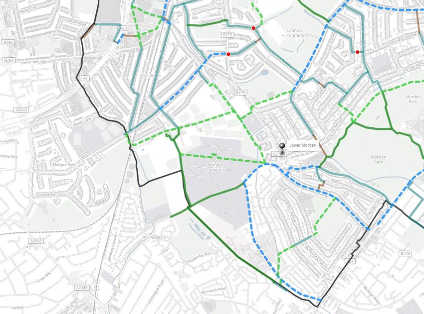
Cold Blows public footpath should be changed to require the footpath to be
enhanced, not just preserved. There is potential to offer a quietway route to
Mitcham Town Centre and across to Canons House if the development is
planned with care.

Mi3: Development of this site must be performed with great sensitivity.
Previous road junction changes have favoured the car at the expense of a
pleasant environment for customers of the Burn Bullock. Guidance should be
added that any development must also contribute to the safety and
enhancement of the road junction including the provision of segregated cycle
lanes and larger pavements. This is probably best achieved via a no right turn
restriction from London Road to Cricket Green A239 and the removal of the left
turn filter on Cricket Green.

Mi4: Planning permission has been granted. It is regrettable that it appears that
no consideration was given to enhancing cycle usage along the neighbouring
footpath.

Mi5: Planning permission has been granted.

Mi6: Guidance should be given with respect to active travel given this is a
pinch point on London Road. Potentially land from this site could be used for a
dedicated cycle lane.

Mi7: [Note: The address of the site and the description is incorrect.]

Mi8: Redeveloping this major part of Mitcham town centre would be a major
undertaking but could be very positive. Despite the policies in the Local Plan,
the guidance has no mention of active travel or cycling. We would suggest that
this site offers the potential to reroute St Mark's Road, creating a simpler road
network with more traffic-free streets, and allowing residential development
adjacent to the school. In particular, St Mark's Road between Majestic Way and
Chalkey Close should close, greatly enhancing the safety of school children.
Any development should also include a cycle parking hub, including 5%
provision for non-standard bicycles.

Mi9: No specific comments.

Mi10: No specific comments.

Mi11: Planning permission has been granted. It is regrettable that it appears
that guidance in the draft London Plan was not followed. Road access to the
accessible flats is from Raleigh Gardens instead of the suggestion to use the
service road in the draft plan. No consideration appears to have been made of
converting Raleigh Gardens into a two-way road, despite being mentioned in
the draft Local Plan.

Mi12: Given the location of this site, it is disappointing to see no guidance with
respect to active travel. Guidance should require that development of the site
includes at least a pedestrian route to Sadler Close.

Mi13: As per site Mi8, this site can contribute towards the pedestrianisation of
the section of St Marks Road between Majestic Way and Chalkey Close.

Mi14: Any enabling development must be legally watertight, addressing issues

                            5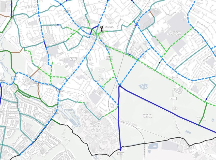
that arose on a similar proposal for the LESSA site in West Barnes. This site is
         not far from Rowan Park estate, and guidance should be added to create a
         pedestrian and cycle route between them. Nearby residents in the Rowan Park
         estate had originally been informed by developers that they would be able to
         walk via the cemetery to Mitcham Eastfields station, something that has not
         come to pass. This site offers the opportunity to complete that plan.

         Mi15: No specific comments.

         Mi16: This important site should have explicit guidance with respect to active
         travel. The previous development on the south west side had reasonable
         access for pedestrians, but no specific connections for people cycling. Given
         the specific policies N3.2c and N3.2l, this site is critical to providing those
         connections from this area of Mitcham and beyond. The guidance should
         mandate high quality pedestrian and cycle routes linking to Miles Road and
         Portland Road. These could access Mitcham town centre via Westfield Road
         and Raleigh Gardens, or via Sadler Close and site Mi12.

         Mi17: Our comments with respect to the junction in site Mi3 also apply here.
         Narrowing the road to one lane in each direction, and building out segregated
         cycle lanes would provide a much more pleasant street environment, which in
         particular may help to make the White Hart and the Burn Bullock pubs more
         commercially viable.

         Mi18: Given the location of this site, many users of healthcare will be tempted
         to drive rather than walk or cycle. It is therefore important that any development
         is welcoming to active travel, especially with respect to cycle parking provision.

Morden   We welcome the intention to ‘prioritise pedestrian and cyclists in regeneration
         of public spaces’ in the overall objective, along with the recognition (at 3.3.24)
         of the current ‘poor experience for pedestrians and cyclists’ and of the need for
         (3.3.27) ‘permeable and easily navigable network of recognisable streets,
         routes and spaces that link in seamlessly with surrounding development and
         facilitate walking, cycling and use of public transport’. We feel that more needs
         to be done in the plan to address these issues including improving the quality
         of existing infrastructure, joining up missing links and mandating that active
         travel is put at the forefront of the development of specific sites.

         Outside the Morden Regeneration Zone, the Local Plan provides little detail on
         surrounding neighbourhoods, including the large areas of Cannon Hill, Lower
         Morden, Merton Park and St Helier wards. This is not acceptable. The absence
         of any specific policy covering areas outside the regeneration zone has the
         potential to be hugely negative for the area over the next 10 years. At a
         minimum, the Morden Local Plan should include a policy stating the ambition
         for a network of active travel routes in the Morden area. As with other
         neighbourhoods, more specificity is required.

         Specific feedback on site allocations:

         Mo1: Development of this site on the boundaries proposed would create a
         significant dead-end area only accessible by Canterbury Road, which would
         lengthen pedestrian and cycle journeys to local shops and facilities,
         exacerbating car-dependency. The local plan should mandate that
         development should only continue if pedestrian and cycle access can be
         provided to Furness Road. This site is the key missing link that blocks a

                                     6
potential continuous pedestrian and cycle route from Netley Gardens towards
Middleton Road and on to Central Road, Morden town centre and Morden
College.

Mo2: Planning Permission was granted for the site recently. We are pleased to
see cycle parking was provided. However, it is disappointing to see no
indication of local road improvements to provide a safe pedestrian and cycle
crossing of Farm Road at the entrance to the recreation ground. This is a
missed opportunity as there is potential for a quiet active travel route through
Morden Recreation Ground and the sports ground from Middleton Road to
Canterbury Road.

Mo3: Planning Permission was granted for the site recently. We are pleased to
see cycle parking was provided, although potentially too much is outdoor rather
than indoor. We believe there is potential to provide segregated cycling
facilities using section 106 money on the adjacent main road. Any enabling
development must be legally watertight, addressing issues that arose on a
similar proposal for the LESSA site in West Barnes.

Mo4: It is imperative that this scheme lives up to the ambitions stated in the
earlier sections (see above) to improve pedestrian and cycle access, including:
     ● Mandating that greenway access is included roughly following the
         Northern line tracks to improve permeability for pedestrians and people
         cycling from the north
     ● Improving connectivity to cycle routes to Raynes Park, via links to
         Martin Way
     ● Improving accessibility for pedestrians and people cycling to Morden
         Hall Park
     ● A clear plan for pedestrian and segregated cycle routes across the
         whole site, potentially making better use of the footpath just west of the
         Northern line at 2 Crown Lane
     ● Improving links to A24 cycle lanes (north and southbound)

Development of residential or commercial premises on this site should include
minimal car parking spaces and compulsory bike storage, particularly given the
high PTAL rating and improved connectivity to cycling routes.

Development around Morden station should include “cycle hub”, providing high
quality cycle storage for both rail passengers and local shoppers, as well as
advice on local cycling, bike servicing and sales of bikes/accessories

Mo5: Development of this site must incorporate changes to improve pedestrian
and cyclist access to A24 northbound (including for cycling for connections to
Wimbledon) and Morden Hall Park (through upgraded crossing facilities).
Specifically there is potential for a quiet pedestrian and cycle route running
East/West through this site parallel to Kenley Gardens. Such a route would
connect to the north end of the Mo4 site and Kendor Gardens via two currently
private service roads next to 1 and 2 Daybrook Road. Strong consideration
should be given to including this directly within the Morden Regeneration Zone
to ensure that the road space at the front of this site is developed appropriately
in order to generate more funding to complete the active travel route.

Mo6: Priority should be given to exploring how development of this site can
improve connectivity between the cycling provision on the A24 heading north
and south from Morden. Specifically, it would be highly desirable to create a

                            7
new pedestrian and cycle link across the railway to Bordesley Road, perhaps to
between 30 and 32 Bordesley Road or via Birchwood Road. Linking the new
bridge to the Lidl access road would also be possible. If designed carefully,
such a route might offer the potential to close and demolish the existing
intimidating long footbridge across the depot which constrains the development
of the depot and offers no cycling facilities.
Mo7: It would be possible to provide a quiet active travel route through the site
to Arras Avenue via the existing private service road, however the benefits of
such a link are lower than at other sites.
Raynes Park We support the policy objectives to improve active travel, however do not
believe that there is adequate specificity on measures that are required. There
needs to be a clear masterplan for the area showing proposed infrastructure
(e.g. pedestrian / cycle / vehicle access), with development of a strategic
walking and cycling network. Particular focus needs to be given to the
pedestrian and cycle infrastructure required to form a cohesive network as part
of the Shannon Corner redevelopments. Specific actions that would help
Merton to deliver on this policy objective include:
● Closing the “missing link” in Merton’s cycle in infrastructure through
Raynes Park town centre, with clear segregated route connecting
Coombe Lane and West Barnes Lane to Kingston Road, Wkye Road
(for LCN 208) and Lambton Road / Pepys Road (for destinations north)
● Removing Raynes Park gyratory to return to two-way traffic with a
protected cycle route each side
● Reallocating car parking space to soft landscaping, restaurant seating
and cycle parking
● Introducing pedestrian crossing at blind bend on Raynes Park Bridge
Road
● Developing new segregated on-road cycle routes, including West
Barnes Lane, Kingston Road, Crossway and Worple Road
● Reducing pedestrian waiting time for those crossing Coombe Lane on
foot near Durham Road
● stop on the southern side of Coombe Lane
● Adding Zebra or Signalled crossings to in residential areas to improve
connectivity, including:
○ Cannon Hill Lane near junctions with Cherrywood Lane and
Eastway
○ Coombe Lane at junction of Cambridge Road (parallel crossing
to allow safe access from Cambridge Rd to the existing two-
way cycle track and bus stop)
○ Durham Rd - to north, in middle point (near Cambridge Rd)
and to the south near Coombe Lane.
○ Copse Hill to connect to Barham Road, Drax Avenue and Ernle
Roads.
○ Grand Drive, multiple possible locations
○ Crossway between Westway and West Barnes Lane
○ West Barnes Lane near Arthur Road, and near Linkway
● Completion of the New Malden cycleway to West Barnes Lane, and a
link north to Coombe Lane via the playing fields and public footpath.
● Development of segregated cycle infrastructure connecting Shannon
Corner shops (e.g. Bodnant Gardens > Beverley Way > Burlington
Road)
8● Development of greenway/quietway cycle infrastructure via Prince
George's Avenue, across Prince George's Field, beside Raynes Park
Vale football club, skirting Cannon Hill Common to join the end of
Heath Drive where the route would split one to link to the lane on
Meadowview Road and one to reach Cannon Hill Lane. A modal filter
on Heath Drive would help protect this route.
● Development of greenway cycle infrastructure along the route of an old
public footpath, from running from Cannon Hill Lane, across the south
side of the AELTC field to Grand Drive, then beside the school, over
Pyl Brook, across the playing fields to Arthur Road and across unused
land to Marina Avenue. When the BBC site in Sutton is developed this
route would be continued on a bridge across the railway.
● Development of greenway cycle infrastructure along Pyl Brook from
Lower Morden Lane to Kingsway utilising an existing bridge near
Derwent Road.
● Investigate greenway cycle infrastructure to New Malden south of the
main railway line via Beverley Park.
● Implementing active travel neighbourhoods in proximity to town centres
in Raynes Park, Motspur Park, and Wimbledon Chase, to improve
attractiveness and safety of walking / cycling to visit local businesses
In addition, we would request policy N3.4.c is amended; the suggested
provision for take away scooters outside restaurants caters for current
customer behaviour during the pandemic, but makes for an unattractive shop
front, especially compared to alternative uses, such as outside dining. Any
solutions need to cater for both uses, and accommodate the growth of cargo
bikes.
In the event that Crossrail 2 is to proceed, future station designs should
incorporate step-free access, ample cycle parking (“cycle hubs”), connected to
existing / new segregated cycle networks, and where the opportunity presents
itself, creation of additional public space / ‘town square’ (e.g. Raynes Park)
Specific feedback on site allocations:
RP1: Any proposed usage of this site should seek to discourage use of motor
vehicles (i.e. car-free development), reflecting the high PTAL score of 5. We
emphasise the importance of enhancing the public footpath next to the site,
and note that it is unsigned at the Durham Road end.
In addition to support active travel to this site:
- A cycle contraflow should be introduced at the one-way segment to the
south end of Amity Grove
- A side road zebra crossing or continuous footway should be introduced
at the south end of Amity Grove
- A zebra crossing should be introduced at the northern end of Amity
Grove to enable pedestrians to cross Durham Rd
RP2: We welcome the guidance that developments must improve the public
realm including pedestrian safety, however this should specifically include
significant amelioration of the public right of way to the rear of the site. The
existing public footpath is very run-down, feels unsafe to walk and was blocked
by fly-tipping the last time the author attempted to use it.
There is potential to develop a north south active travel route across the RP2
9site towards the RP3 site, existing footpath and Tesco, providing a more direct
route to shops and education. Guidance should require that site RP2 and RP3
are developed under a masterplan to avoid missed opportunities from
piecemeal development.
RP3: Guidance should explicitly require the northern boundary of the site (Pyl
Brook) to be opened up as a greenway, for pedestrian and cycle traffic. Any
redevelopment should include clear provision for cycle access to and parking at
the superstore, enhance and integrate with north/south cycle routes along West
Barnes Lane and Beverly Way. Opportunities to link the greenway route via a
ramped bridge to the east side of the railway line should be explored, to
provide an accessible route for both pedestrians and cycles, to reduce the
barrier presented by the railway line.
Any redevelopment of the Tesco store should consider how it could reduce
vehicle travel; introducing an active frontage on Burlington Road would bring
the store within walking distance of many more residents, reducing demand for
vehicle travel.
RP4: We welcome guidance that the site must provide walking and cycle
access via Bodnant Gardens, however believe that this is not sufficient. Future
development of this site must include a North/South pedestrian and cycle route
through the site, connecting Bodnant Gardens with Bushey Road and opening
up access for journeys to Raynes Park High School and the superstore located
at site RP3; combined with works on Beverley Way, this would improve
permeability of the development, and facilitate ‘multi stop’ shopping trips.
Despite these measures, given the site's location, it is unlikely that a retail
development will avoid being heavily based on the car. Given potential future
weaknesses in retail, other options for this site should be explored, including
other uses that may be well suited to close proximity to the A3 (e.g. “Last mile”
distribution facilities, such as those operated by cargo bike), as well as
residential.
RP5: These facilities will be a great addition to Raynes Park, however new
plans have a large car park, with access situated on Grand Drive, which is a
dangerous road for people cycling and does not provide an attractive
pedestrian route from Raynes Park station. The result is almost every player or
coach is encouraged to arrive by car.
Work needs to be done with AELTC and the council to encourage arrival by
walking from the local train stations or cycling. There is great potential for this
site to be a key section in a local network of quiet pedestrian and cycle routes.
A pedestrian and cycle path across this site from the back entrance on Cannon
Hill Lane could link to a North/South link via Parkway and the playing fields
next to Raynes Park Vale FC. The route across this site would follow the
Southern boundary and exit onto Grand Drive. Additionally a new
cycle/pedestrian path could be opened from Motspur Park station to Grand
Drive - 80% of this path already exists going through Joseph Hood Park and
the private grounds of Kings College emerging alongside the lane next to John
Fisher school (the route follows that of a historic public right of way).
The traffic on Grand Drive is constant and if nothing is done to encourage
active travel to the new facility it will be further exacerbated.
10RP6: This site remains available for development as previous plans did not
adhere to the planning inspector's clear guidance that permission was to be
granted for Meadowview Road development solely on the basis of bringing the
field into active sporting use. The guidance must be followed with respect to
sporting use, especially as sports clubs have now been identified that wish to
use the field.
The current planning proposal is poor for active travel. It takes the existing
dedicated high quality pedestrian/cycle path and chops it into three pieces.
Given this is the highest quality piece of active travel infrastructure in the area,
this is not acceptable. Alternative vehicle access routes (e.g. via Greenway)
should be considered, as should options to provide a North/South across the
site to link to the existing high quality path, providing an alternative to the
hostile environment on Grand Drive.
Cycle storage should be provided for all apartments and homes, in line with
London Plan guidelines. London Plan guidelines for car space allocation should
not be exceeded. < 1 car space per dwelling.
RP7: This site has a single point of access via a narrow bridge that is not
welcoming to pedestrians and people cycling. All proposals made for the site
have failed to address this. Guidance should be made that the site cannot be
developed without a second point of access. Without this, there is a risk that
residents will tend to use cars to journeys that are very short as the crow flies,
such as to West Wimbledon School. Cycle storage should be provided for all
apartments and homes, in line with London Plan guidelines; due to close
proximity to Raynes Park station and PTAL score of 4-5, a maximum of 0.5 car
parking spaces per dwelling should be provided.
RP8: The location of this site, adjacent to Motspur Park railway station,
presents a unique opportunity to create a “cycle hub”, providing high quality
cycle storage for both rail passengers and local shoppers, and helping to
reduce vehicle use within a relatively car-dependent area of Merton. Any future
redevelopment must include these facilities in addition to provision of a library.
RP9: No additional comments
South Wimbledon Policy N3.5f and N3.5i are welcome but provide very weak guidance on the
need for active travel.
They need to be significantly strengthened and reworded. Current proposals to
“encourage” active travel are inadequate if not supported by enabling
infrastructure that creates safe spaces for pedestrians and people cycling. In
particular, segregated cycle lanes should be specified in the plan as part of a
network of pedestrian and cycle routes (not just isolated improvements).
This network should include improvements to Merton High Street, Merantun
Way, and High Path. In particular, the opening of the new Harris Academy on
High Path has increased the necessity for safe pedestrian and cycling access
to and through this area from all directions.
Redevelopment of the High Path estate presents a unique opportunity for
properly planned quietway access through and around this large site. The
Local Centre boundary should be extended south and east to include the area
bounded to the south by Merantun Way and to the east by Abbey Road.
11More details are set out in our response to the ‘Transport’ section of the Local
Plan.
Wimbledon There is an urgent need to reduce motor traffic in Wimbledon town centre;
Wimbledon has become an increasingly unwelcome and unappealing place to
shop or sit out in cafes because of the fumes, noise and threat of motor traffic.
Other nearby town centres, such as Kingston, have thrived based on
pedestrianised spaces, and have invested in cycle provision.
To this end, we support the policy objectives to build a vibrant, green town
centre, and support policy N3.6.c, h, i, j, p, with the following comments:
N3.6.i - greater specificity is required on the proposed measures to improve the
town centre for people cycling; of note, there is no detail provided on this in the
Transport Local Plan or its appendices. Fully segregated routes for people
cycling should be sought.
N3.6.j - we support introduction of new bridges across the railway, and
enhancement of the railway forecourt; any new bridges over the railway should
provide ramped access and segregated pedestrian and cycle facilities, to
maximise connectivity and limit barriers to accessibility; Wimbledon Bridge
should be widened as part of any extensive redevelopment of Wimbledon
station or Wimbledon Bridge House, with segregated cycle lanes provided.
N3.6.p - greater specificity is required. The main centres in Wimbledon High
Street and near the station need to be made accessible to people with:
- Crossings on every arm of roundabouts (including Wimbledon Hill
Roundabout, Church Rd roundabouts (opp. St. Mary’s), Worple Rd
roundabout)
- More zebra crossings both along shopping streets and in residential
areas
- Wider footways
- Protected cycle routes.
We have outlined additional comments in the ‘Transportation’ section of this
response
N3.6.r - add a new policy: “Promote and support the need for sustainable,
environmentally friendly development in the Plough Lane area to ensure that
traffic levels are managed to improve local health and wellbeing and that
incoming businesses contribute to a high-quality retail and leisure offering.”
N3.6.s - add a new policy: “Constrain activities that are environmentally
unfriendly, pollution-generating, or yield high volumes of HGV traffic in
industrial estates such as Weir Road where the surrounding area is
increasingly residential. Encourage relocation of activities which generate high
levels of HGV movements through Wimbledon centre.”
In addition, we have the following commentary on the justifications provided:
3.6.5 - The starting point for greening is cutting out or reducing motor traffic,
leading to cleaner air and quieter more pleasant streets. The need to reduce
motor traffic should be more explicitly stated.
3.6.18 - This should include facilities for last-mile delivery model and bike
12delivery services, recognising that these are not necessarily based in town
centre locations
3.6.19 - The final sentence should additionally include reference to co-working
spaces
3.6.20 - This should include a reference to Wimbledon Stadium
3.6.22 - The final sentence should include “... and limited”
3.6.23 - Sustainable access to Wimbledon Village Centre from Wimbledon
town centre would be improved by an electric bike hire hub at the bottom of
Wimbledon Hill. Safe segregated cycle access between Wimbledon Village and
Wimbledon town is included as part of our response to the ‘Transportation’
section of this consultation and should also be an ambition, as are the routes
between Wimbledon town centre and the AELTC, and Wimbledon Stadium in
Plough Lane
3.6.24 - Wimbledon village’s “attractive environment” is very negatively
impacted by the high levels of traffic that can create a polluted, unpleasant
environment, and a ‘barrier’ for pedestrians crossing the road. It is vital that
measures are taken to widen pavements and improve the high street setting for
shoppers. The current temporary closure of Wimbledon High Street West
should be made permanent, with al fresco dining opportunities created.
3.6.27 - Step-free access to the southbound platform of Haydons Road railway
station should be implemented as a priority.
Specific feedback on site allocations:
Wi1: Opportunities should be sought to improve permeability of the site for
walkers and cyclists; namely: connectivity with Battle Close and Autumn Close;
linkage to Garfield Road (if feasible with existing land owners); enhancement of
footpaths linking Garfield Road / North Road / Battle Close, including removal
of barriers to cycle accessibility on the path linking Garfield Road and North
Road.
Wi2: Development should be ‘car free’ given its high PTAL score of 6a;
appropriate cycle parking should be provided for both short term and long term
uses
Wi3: Any future masterplan for the area surrounding the AELTC must
incorporate enhanced cycle provision (segregated) on Church Road. Inclusion
of additional public amenity within the masterplan would be welcomed, such as
a perimeter pedestrian / cycle route around Wimbledon Park Lake, and
introduction of new walking / cycling routes connecting Wimbledon Park /
Revelstoke Road to the southern end of Church Road, improving access to
Wimbledon Village. In addition, opportunities to introduce sustainable
transportation to/from the AELTC site should be investigated, such as electric
bicycle hire / bike taxis.
Wi4: Site does not exist in plans provided
Wi5: A pedestrian route between the Broadway and Hartfield Road should be
maintained as part of any future development. Development should be ‘car
13free’ given its high PTAL score of 6a; appropriate cycle parking should be
provided for both short term and long term uses.
Wi6: Development should be ‘car free’ given its high PTAL score of 6;
appropriate cycle parking should be provided for both short term and long term
uses.
Wi7: Any redevelopment of this site must safeguard a future pedestrian cycle
and access point to the Wandle trail, with minimum accommodation of a 2.5m
shared use path (LTN 1/20) on the brief perimeter of the site adjacent to the
river Wandle
Wi8: Development should be ‘car free’ given its high PTAL score of 6;
appropriate cycle parking should be provided for both short term and long term
uses, including a “cycle hub” to accommodate cycle parking for commuters
using the railway station
Wi9: Development should be ‘car free’ given its high PTAL score of 6;
appropriate cycle parking should be provided for both short term and long term
uses. If a hotel or offices are to be developed, appropriate ‘off road’ loading /
unloading space must be provided for vehicles, in order to ensure the road
and/or pavement is not obstructed. The redevelopment of this and other sites
on St George's Road should be used as an opportunity to create protected
cycle routes to and through central Wimbledon, with access to an improved
railway-side cycle/pedestrian quietway
Wi10: Development should be ‘car free’ given its high PTAL score of 6;
appropriate cycle parking should be provided for both short term and long term
uses. If a hotel or offices are to be developed, appropriate ‘off road’ loading /
unloading space must be provided for vehicles, in order to ensure the road
and/or pavement is not obstructed
Wi11: A pedestrian route between Broadway and Hartfield road must be
maintained, and existing public space provided by the piazza must be
protected / enhanced. A potential to create a two-way cycle route through the
site between Beulah Road and Queen’s Road should be assessed.
Any proposals for the site must accommodate:
● Two-way traffic flow on Hartfield road
● Full segregation of cycle routes through Wimbledon Town Centre and
along the length of the Broadway
● Improvement of pedestrian environment (e.g. widening of pavement /
reallocation of road space / soft landscaping)
● Short and long-term cycle parking in line with London Plan
Wi12: Any further development of this site must incorporate safe, segregated
cycle access along Plough Lane and connecting with Garratt Lane and
Wimbledon Road.
Continuing development of this site must incorporate a shared-use north-south
pedestrian/cycle route between Plough Lane and Riverside Road as per
planning permission already granted. Plough Lane and Summerstown require
protected cycling provision to LTN 1/20 standards.
Provision must be incorporated for cycling / pedestrian access to the Stadium
14and residential properties. Safe cycle storage and facilities (lockers, showers
etc.) must be incorporated in all residential/office developments, and must meet
London Plan 2020 guidelines as a minimum.
Wi13: The redevelopment of this site must be used as an opportunity to
improve the streetscape of Worple Road, by:
● Substantially reducing or removing through motor traffic,
● Including formal crossings on the roundabout
● Providing more and quicker crossings on Worple Road and Wimbledon
Hill
● Reallocating traffic lanes to footway space and soft landscaping
● Providing protected cycle facilities along the length of Worple Road
and Wimbledon Hill
● Development should be ‘car free’ given its high PTAL score of 6a
● Appropriate cycle parking should be provided for both short term and
long term uses.
● Provision of a pedestrian link between Worple Road and St George’s
road is supported.
Wi14: See comments for Wi13.
Wi15: Development should be ‘car free’ given its high PTAL score of 6a;
appropriate cycle parking should be provided for both short term and long term
uses. Development should ensure pavements on Trinity Road and Broadway
are widened, to improve public realm and to create space for safety
improvements to the road junction for cyclists and pedestrians.
Wi16: It is essential that any development of this site accommodates future
widening of Wimbledon Bridge, and the construction of a ramped, segregated
pedestrian / cycle bridge to the north of the railway station. Development
should be ‘car free’ given its high PTAL score of 6a; appropriate cycle parking
should be provided for both short term and long term uses, and a commuter
cycle hub provided adjacent to the railway station.
Climate Change No comments
Places and spaces in D5.1.c: We support prioritisation of pedestrians and cyclists within the public
a growing borough realm; greater specificity should be added to this policy with public realm
remaining accessible to the general public 24x7 and with cycle routes
segregated from pedestrians where feasible
D5.3.vii: This policy should be adapted to ensure that construction impacts on
pedestrians and cycles are also adequately mitigated
Economy TC7.7: We support policy TC7.7 to protect local / corner shops, as a key
enabler to 15-minute neighbourhoods and providing residents’ with essential
amenities that are accessible via active travel modes
EC7.2: We support policy (b) to only support proposals for development which
do not adversely affect pedestrian, cycle or traffic movement, road safety or
local amenity. Specifically, Merton should not support construction of new or
expansion of existing waste management facilities where this results in an
increase in goods vehicle movements. Such businesses lead to a large number
15of HGVs transiting through Merton, using single-carriageway roads and
impacting pedestrian and cycle safety. We support relocation of existing sites
which necessitate high levels of HGV movements from areas which can only
be accessed via town centres (e.g. Wimbledon, Raynes Park) to sites which
abut major highway routes (the A3). This will reduce the number of HGV traffic
transiting through Merton single-carriageway roads and threatening pedestrian
and cycle safety, and having a negative impact on air quality.
Green and Blue O8.1: We support policies (b) to improve accessibility of open space and (f)
Infrastructure enhancing accessibility of our waterways. Many of Merton’s green spaces
provide key walking and cycle links in a pleasant and safe environment and are
an essential component of our borough’s active travel network. However, as
part of this policy, the quality of the walking and cycle network within Merton’s
green spaces needs to be improved. Specifically:
- Removal of barriers to access (such as ‘chicanes’), which can impede
access for those with pushchairs, wheelchairs, or many non-standard
bicycles
- Where feasible, widening of existing shared use pathways to meet
current DfT guidance (3m wide where 300 cyclists per hour) or creating segregated cycle lanes
(such as Raynes Park - New Malden cycleway)
- Introduction of all-weather surfaces in order to reduce the risk of
portions of the network becoming “mud bogs” during winter months,
improving accessibility for both pedestrians and people cycling
Health and Wellbeing HW2.1: We support policies (f) to create safe, healthy and accessible
neighbourhoods, and (g) encourage more walking and cycling. However we
would ask that these policies more explicitly call out Low Traffic
Neighbourhoods and School Streets as being examples of effective
interventions that would support the delivery of these policy goals
Housing Provision H4.2: This policy needs to provide more explicit guidance on required cycle
and vehicle parking facilities; specifically it should state that
- The minimum cycle parking requirements are as per London Plan Policy T5,
with provision of recharging facilities for electric bikes and provision for at least
5% of bicycles to be ‘non-standard’.
- The maximum number of car parking spaces permitted is as per London Plan
Policy T6, notably with all PTAL 5 or 6 developments being “car free”
H4.5: We support the requirement for student accommodation to provide high
quality cycle parking facilities, however the policy should be more explicit, and
reference (a) minimum standards for short- and long- stay parking for student
accommodation, per London Plan Policy T5, (b) provision of recharging
facilities for electric bikes and (c) provision for at least 5% of bicycles to be
‘non-standard’.
Infrastructure No comments
Transport and Urban T6.4: Improving Travel Choices
Mobility
T6.4a - The phrase 'Vision zero' should be clarified here. Does it refer to the
Mayor's goal that all deaths and serious injuries will be eliminated from
London's transport network by 2041? If so, this aim is supported. However in
16the context of the Council’s stated goal to achieve 'net zero' in relation to
climate change, this term is open to misinterpretation when determining
planning applications without adequate definition
T6.4b - Should read 'encouraging people to travel less by car’'
T6.4d - We agree that a low carbon economy is important but the linkage to
improving travel choices is not clear
T6.4e - We support this, but an additional objective is required to create a
coherent network of walking and cycling routes that support a modal shift to
active travel.
T6.4f - Major sites should not only have to undertake a healthy streets
assessment, but also reach a minimum score and make changes to their
scheme if they don't achieve this. (Paragraph 8 of the 'Justification' suggests
this is the policy, so it should be reflected in the policy section.)
T6.4g - A new policy should be established that Merton will develop an
integrated cycle network so that all of Merton’s residents are in close proximity
to a cycle route, with routes every 250-400m
Paragraph 3 of the 'Justification' section suggests that an additional policy point
should also be added along the lines of:
"New developments will need to encourage a reduction in car use and support
the shift to sustainable transport alternatives in the first instance and support
remaining vehicle journeys being low carbon."
Para 7 of Justification is not clear and its meaning and reason for inclusion in
the Justifications for the policy made clearer.
T6.5: We support the requirement of new development to maximise
permeability and improve walking links. However this policy should not be
applied solely to private development, but additionally to existing council-
managed spaces. Merton needs to develop a strategic walking and cycling
network, and as part of this improve the quality of the pedestrian environment,
including pedestrianisation where feasible (e.g. Wimbledon Village High Street
West, Wimbledon Broadway, St Mark’s Road (in line with our comments on site
Mi8).
In the application of this policy to private development, any active travel links
must be accessible to the general public 24 hours a day / 7 days a week. There
are unfortunately examples of historic links through private land (e.g.
Schoolgate Drive) that have been closed to the public.
T6.5b - We support the aims of this policy, however it should go further in
contributing to liveable and low car neighbourhoods than just providing better
walking connections; we suggest adding '...walking connections and facilities
other measures that could include places to sit, socialise and shelter and
facilitate street activities.'
T6.6: Prioritising Cycling
T6.6: We support the requirements to be made of new developers in providing
cycle parking meeting London Plan standards, provisioning for non-standard
17cycles, electric cycle charging, as well as provision of showers, storage
facilities, and changing rooms in large non-residential sites.
Whilst we agree that developers should contribute to and support the delivery
of a strategic cycle network, we additionally need to see further leadership from
Merton council in defining and delivering this strategic cycle network.
The proposals within the Local Plan represent a small increment on measures
included within the LIP3 plans, but do not yet represent a fully coherent vision
of an integrated cycle network within the borough that reflects existing and
proposed infrastructure, nor reflects the level of ambition we would expect to
see in a plan with a lifespan of ~10 years.
We have provided detailed commentary on the specific measures included in
the Local Plan in the following section.
All future cycle infrastructure within Merton (whether delivered by Merton or
developers) needs to be of high quality, meet latest DfT design guidance (LTN
1/20) at a minimum. Specifically, proposals should:
- Be designed with users of all ages and abilities in mind
- Maximise opportunities to improve permeability
- Be accessible to members of the public 24 x 7
- Provide full segregation between cycles and pedestrians and avoid
shared space unless delivery of the scheme would be otherwise
infeasible
- Accommodate non-standard bicycles
- Avoid ‘chicanes’ and other barriers to access
- Avoid requiring cyclists to dismount
- Are constructed with a smooth, all-weather, enabling year round usage
- Incorporate lighting where appropriate, in a manner sensitive to the
immediate environment of the route (including use of low-level / motion
activated lighting in sensitive areas or where dark skies are to be
preserved)
New routes should be protected through creation of public rights of way.
T6.6e - We support this requirement, however there is no definition of 'large'
non-residential development. Smaller sites should also consider provision at an
appropriate scale to support staff travel by bicycle.
This policy requirement also only relates to staff provision; provision should
also be made for visitors to arrive by bicycle.
The relevance of paragraph 1 of the ‘Justification’ to this section is unclear.
The option for developers to pay for on-street cycle parking (paragraph 5) is not
adequate; cost for residents to park in any on-street provision should be
covered in perpetuity, reflecting the same level of provision as if it was provided
on the property itself.
The contents of paragraph 6 regarding mobility services are relevant and
supported, however are not reflected in the policies within T6.6. Additional
policies should be created to reflect this paragraph.
T6.7: Managing Transport Impacts
T6.7a: This policy should be clarified to ensure that any impacts on pedestrian
18and cycle infrastructure during construction are appropriately mitigated (e.g.
road diversion routes consider cyclists, provision of temporary segregated
infrastructure)
T6.7b: We do not support this policy in its current form, as we believe the
current wording provides scope for parking to be included within developments
with high PTAL scores; this policy should be updated to state that the
maximum number of parking spaces included within a development should not
exceed those defined in the London Plan Policy T6; notably the 2020 revision
of this policy requires all residential, retail, hotel and leisure developments in
PTAL 5 or 6 areas to be “car free”.
T6.7d: We support the policy, however wording should be amended to read
“checked and validated Transport Assessment”
T6.7e: We support the principle of this policy, however Officers have agreed
this year that the classification of 'London Distributor Roads' should no longer
be used, and is not referenced elsewhere in current London transport planning
policy. This legacy reference should be eliminated from this policy.
Nothing is said about how the Council will tackle poor public transport defined
in para 5 of the Justification as areas with a PTAL score of 2 or below - which is
a large proportion of the borough according to the map. This will be crucial to
achieve the stated aims of the Local Plan.
T6.8: Parking, Deliveries, and Servicing
T6.8: We do not support policy (a) in its current form, in line with the comments
noted above for T6.7. In addition, in line with London Plan policy T6.C, we
believe the wording of policy (a) should be updated to state that if the
introduction of a new controlled parking zone would enable the delivery of a car
free development in a PTAL 3 or 4 area, Merton will assess the feasibility of
doing so.
T6.8k - Merton should encourage rather than 'support' distribution and
collection facilities that support low carbon vehicle fleets.
We believe that the council should not support construction of new or
expansion of existing waste management facilities where this results in an
increase in goods vehicle movements. Such businesses lead to a large number
of HGVs transiting through Merton, using single-carriageway roads and
impacting pedestrian and cycle safety.
Transport and Urban We have outlined detailed commentary on the specific cycling measures
Mobility - proposed by Merton in the Local Plan. We have prepared these comments on
Commentary on the basis that the Local Plan will have a 10+ year lifespan, and have set the
level of ambition accordingly.
cycling measures
proposed by Merton Note that our comments are solely on the “Proposed Cycling Measures”
document; the proposals in the “Walking and Cycling Routes Map” documents
are not clear and further clarification was not provided by Merton when
requested.
1 - Install a Toucan/Pedestrian phase across Windmill Road and Croydon
Road. Works are due to commence summer 2019 and will require uptake
19of common land - Project already delivered. Improves pedestrian safety but
does not make material contribution to cycle network
2- Investigate walking/cycling connections in the region of pollards hill
including connections into Croydon. (Links to liveable neighbourhood
bid at pollards hill). - Comments TBD
3- Investigate improvements on Sandy Lane and Streatham road
including wayfinding interventions. - Wayfinding is not sufficient to deliver
improved pedestrian / cycling environment
4- Signed wayfinding scheme connecting Mitcham/Tooting & Colliers
Wood (avoiding the northern end of western road). - Wayfinding is not
sufficient to deliver improved pedestrian / cycling environment; at a minimum,
chicane barriers need to be removed. As the route runs through a park, it is not
open at night time (arguably when people cycling are more at risk) and an
adequate route needs to be in place 24x7
5- Improve cycle facilities in region of Colliers Wood bus depot. - -
Temporary segregation installed on Merton High Street needs to be made
permanent, with provision extended beyond current implementation
6- Investigate measures to link up the cycle superhighway (cs7) with
Clapham common to Wimbledon quietway. - Any proposed linkage following
residential streets needs to be accompanied by a signalled junction with A238.
Currently people cycling on the southbound carriageway to the A238 trying to
access roads in Denison Road area face unsignalled and intimidating turns to
the right, requiring them to merge into vehicular traffic from the segregated
cycle lane, then stop and block vehicular traffic whilst waiting to turn right
7- Tighten up kerb geometry at junction of East Road/South Road and the
mini roundabout on North Road/East Road. - Measures to tighten the
geometry here and at any other ‘wide’ junctions are welcome to improve
pedestrian safety. Of particular concern is the junction of Queens Road with
Haydons Road, where a wide geometry encourages vehicles to maintain high
speeds and contributes to excessive risk to pedestrians wishing to cross this
junction. Many of these pedestrians are children and families given it is route to
school for four local primaries.
Merton should consider opportunities to implement ‘pocket parks’ or secure
cycle storage on land ‘unlocked’ following the tightening of geometry
8- Signing and wayfinding scheme to avoid the South Wimbledon
junction. This is an inadequate response to the risks associated with the South
Wimbledon junction, which sees a high volume of commuter cycle and
pedestrian traffic flow, which will increase following the opening of the Harris
Academy on High Path. Initiative #21 to improve the junction itself should take
precedence
9- Improve ped/cycle timings at junction of Coombe Lane/West Barnes
lane financial year 2020-2021. Present timings appear to be satisfactory
10- Segregated path to link Raynes Park with New Malden alongside
railway line. Works expected to be complete June 2019. Works have been
completed. The section running parallel to the railway track, with fully
20You can also read