Middle Renwick Road, Blenheim - Proposed cycle facilities - Report prepared for
←
→
Page content transcription
If your browser does not render page correctly, please read the page content below
Level 1, 284 Kilmore Street
Transport Planning and Design

             www.viastrada.nz

                                 Middle Renwick Road, Blenheim
                                                    Proposed cycle facilities

                                                                        Report prepared for
                                           Marlborough District Council and Marlborough Roads

                                                                                October 2020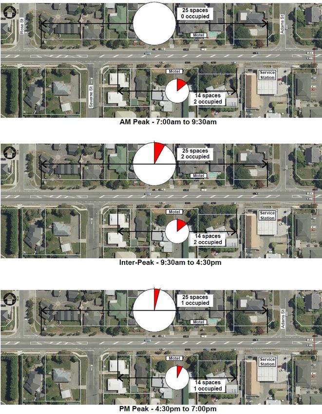
This document has been prepared for the benefit of Marlborough District Council and Marlborough
Roads. No liability is accepted by ViaStrada Ltd, or any of its employees or sub-consultants with
respect to its use by any other party.

Quality Assurance Statement
                               Project manager:   Warren Lloyd
                                                  Director – Senior Transportation Engineer
                                                  027 292 9830
ViaStrada Ltd                                     warren@viastrada.nz
Level 1,
284 Kilmore Street             Prepared by:       Gemma Dioni, MSc, BSc
PO Box 22 458                                     Senior Transportation Engineer
Christchurch 8140                                 021 400 599
New Zealand                                       gemma@viastrada.nz
Phone: (03) 366-7605
www.viastrada.nz               Reviewed by:       Warren Lloyd
info@viastrada.nz                                 Director – Senior Transportation Engineer
                                                  027 292 9830
                                                  warren@viastrada.nz

Project number:                1124-10
Project name:                  Middle Renwick Road, Blenheim
Document version                                  Date
V05 (not issued – edits discussed with BP)
Final report V04                                  6/10/20206/10/2020
Third draft V03 (for client review)               10/09/2020
Second draft V02 (for client review)              20/08/2020
First draft V01 (for client review)               3/08/20203/08/2020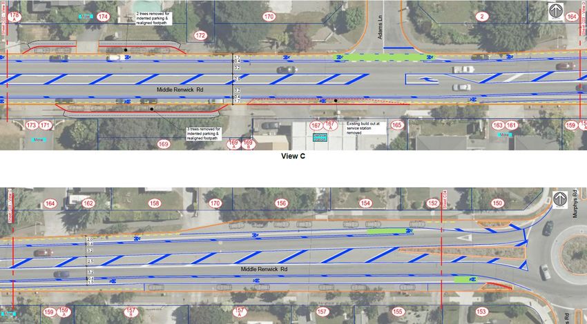
Middle Renwick Road, Blenheim – Proposed cycle facilities

Table of Contents
1       Introduction .......................................................................................................................................... 1
1.1              ViaStrada project team .............................................................................................................. 1
1.2              Report format ............................................................................................................................ 1
2       Existing conditions and future demands ............................................................................................... 2
2.1              Current context .......................................................................................................................... 2
2.2              Pedestrian facilities and demands ............................................................................................. 3
2.3              Cycle facilities and demand ....................................................................................................... 4
2.4              Public transport & School buses ................................................................................................ 5
2.5              General traffic demand .............................................................................................................. 5
2.6              Traffic speeds ............................................................................................................................. 6
2.7              Parking ....................................................................................................................................... 6
2.8              Existing street trees ................................................................................................................... 8
3       Crash data and risk ................................................................................................................................ 8
3.1              Risk Ratings ................................................................................................................................ 8
3.2              Crash data .................................................................................................................................. 9
3.3              Near miss data ......................................................................................................................... 10
4       Strategic Context ................................................................................................................................. 11
5       Target user .......................................................................................................................................... 11
5.1              Enthused and confident ........................................................................................................... 11
5.2              Interested but concerned ........................................................................................................ 11
6       Stakeholder Engagement .................................................................................................................... 12
7       Project outcomes ................................................................................................................................ 12
8       Buffered cycle lanes ............................................................................................................................ 13
9       Option development ........................................................................................................................... 14
9.1.1            Option 1 ................................................................................................................................... 14
9.1.2            Option 2 ................................................................................................................................... 14
9.1.3            Option 3 ................................................................................................................................... 14
10      Multi-criteria analysis.......................................................................................................................... 15
11      Preferred Option ................................................................................................................................. 17
11.1             Parking ..................................................................................................................................... 18
11.2             Street trees to be removed...................................................................................................... 19
11.3             Proposed layout ....................................................................................................................... 20
11.4             Proposed cross-sections .......................................................................................................... 22

Project 1124-10                                                      i
Middle Renwick Road, Blenheim – Proposed cycle
                                                                                                            facilities

11.5                Next Steps ................................................................................................................................ 23
11.5.1              Safety audits ............................................................................................................................ 23
11.5.2              Public consultation................................................................................................................... 23
12         Services and rough order costs ........................................................................................................... 23
13         Additional project considerations ....................................................................................................... 24
14         Appendices .......................................................................................................................................... 24
PAK’n SAVE / Kmart access for people travelling on foot and by bike ........................................................... 61
Shared path link to Murphys Road ................................................................................................................. 62
Off road cycle options at roundabout............................................................................................................. 62

List of Appendices
Appendix A          Traffic Volumes from Waka Kotahi ........................................................................................... 25
Appendix B          Parking ...................................................................................................................................... 26
B.1                 Weekday parking - Zone 1 ....................................................................................................... 26
B.2                 Weekday parking - Zone 2 ....................................................................................................... 27
B.3                 Weekday parking Zone 3 ......................................................................................................... 28
B.4                 Weekend parking All Zones ..................................................................................................... 29
B.5                 Weekday parking raw data ...................................................................................................... 30
B.6                 Weekend parking raw data...................................................................................................... 31
B.7                 Photos of illegal parking and advertising activity .................................................................... 32
Appendix C          CAS crash data .......................................................................................................................... 33
C.1                 Vulnerable user crashes........................................................................................................... 33
C.2                 Battys / Murphys roundabout all road users’ crashes............................................................. 34
C.3                 All road user crash data for the balance of the route ............................................................. 35
C.4                 Near miss crashes .................................................................................................................... 36
Appendix D          Strategic context ....................................................................................................................... 37
D.1                 Government Policy Statement on Land Transport 2018–28 ................................................... 37
D.2                 Road to Zero: A New Road Safety Strategy for NZ (2019) ....................................................... 38
D.3                 Regional Land Transport Plan 2015–2021 ............................................................................... 39
D.4                 Marlborough District Council Walking and Cycling Strategy 2019-29 ..................................... 39
Appendix E          Buffered Cycle lanes ................................................................................................................. 41
E.1                 Introduction ............................................................................................................................. 41
E.2                 Buffered cycle lane design ....................................................................................................... 41

                                                                         ii                              Marlborough District Council
                                                                                                             and Marlborough Roads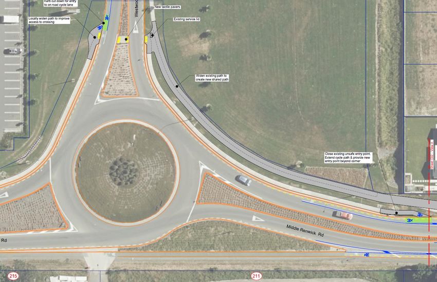
Middle Renwick Road, Blenheim – Proposed cycle facilities

E.2.1        Parking side buffer configuration ............................................................................................ 41
E.2.2        Traffic adjacent buffer configuration....................................................................................... 43
E.3          Design parameters ................................................................................................................... 43
E.3.1        Buffered cycle lanes, establishing parking ............................................................................... 44
E.3.2        Instructions for use .................................................................................................................. 45
E.3.3        Calculate element widths ........................................................................................................ 45
E.3.4        Re-distribute width if necessary .............................................................................................. 45
E.3.5        Tips for finding space ............................................................................................................... 45
Appendix F   Option Development ................................................................................................................ 49
Appendix G   Multi Criteria Analysis ............................................................................................................... 52
Appendix H   Preferred Option 2 Plans .......................................................................................................... 54
Appendix I   Services ..................................................................................................................................... 58
Appendix J   Rough Order Cost Estimate ...................................................................................................... 59
Appendix K   Additional Project Considerations ............................................................................................ 61

Project 1124-10                                                 iii
Middle Renwick Road, Blenheim – Proposed cycle facilities
1 Introduction
ViaStrada has been engaged by Marlborough District Council and Marlborough Roads to consider
options for implementing cycle facilities on Middle Renwick Road from Westwood Avenue to the
Battys Road/Murphys Road roundabout (inclusive of these intersections), in the Springlands area of
Blenheim, as shown in Figure 1-1.
Figure 1-1: Middle Renwick Road study area (source: www.openstreetmap.org)
There are currently on-road cycle lanes marked on the carriageway on Middle Renwick Road to the
east of Battys Road and at the Westwood Ave roundabout.
Middle Renwick Road forms part of the State Highway (SH6) network managed by Waka Kotahi NZ
Transport Agency providing a connecting to SH1 (Picton and Christchurch to the east) and Havelock
and the west coast to the west.
1.1 ViaStrada project team
The ViaStrada staff involved on this project:
Warren Lloyd, project leader and technical lead
Gemma Dioni; technical and report writing assistant
Jon Ashford; data analysis and scheme design.
1.2 Report format
The report considers strategic alignment, the existing network conditions and demands, the existing
crash risk and trends within the crash data, and a review of the accuracy and relevance of data used.
Describes the background context and data related to the existing area
Describes the proposed options for the area when considered from a holistic approach; and
Assess the various options and make recommendations for a preferred option.
1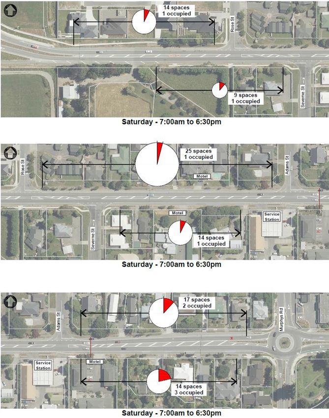
Middle Renwick Road, Blenheim – Proposed cycle
                                                                                      facilities

2         Existing conditions and future demands
2.1       Current context
It is predominantly residential land use fronting Middle Renwick Road (SH6) in the study area as
shown in Figure 2-1 . There are motels and a petrol station also along this route. At the western end,
Middle Renwick Road, it is mainly newly developed large format retail, with additional land in this
area zoned for future development. There are larger high schools to the east, in addition to local
shops on the south side of Middle Renwick Road. There are likely to be residents in this area making
local trips to and from the shops, schools and into central Blenheim, which is located to the
southeast.

Figure 2-1: Land-use and property zoning along Middle Renwick Road (Source: Marlborough District Council)

                                                  2                     Marlborough District Council
                                                                            and Marlborough Roads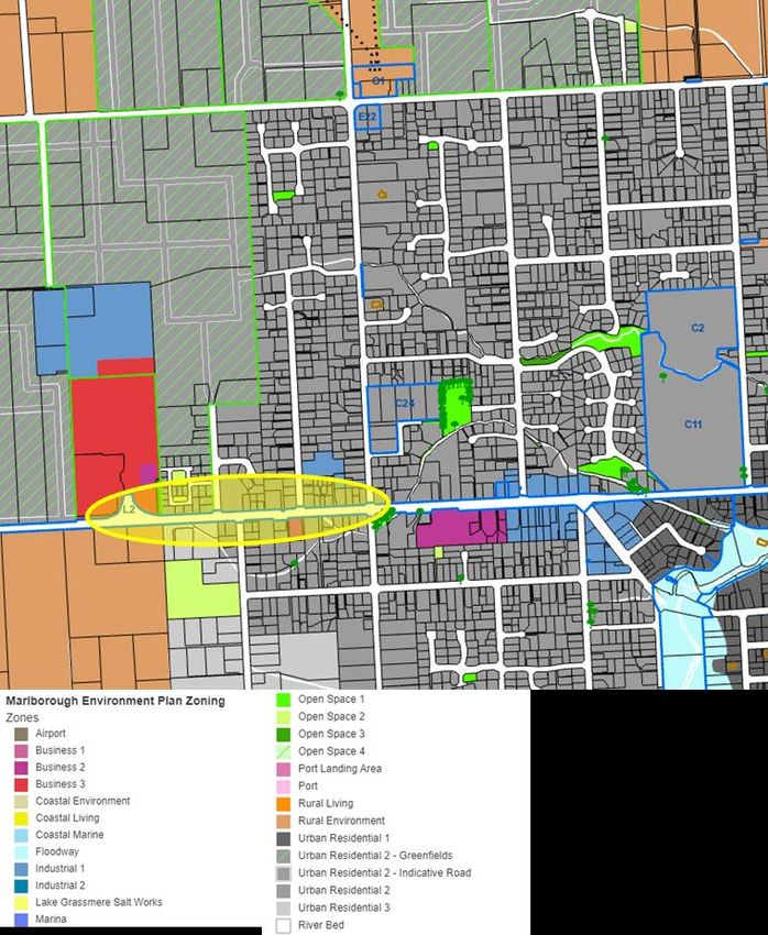
Middle Renwick Road, Blenheim – Proposed cycle facilities
2.2 Pedestrian facilities and demands
Walking is a healthy and affordable choice of transport. Safe, attractive and connected walking
facilities will make walking an even more inviting choice. Connectivity to local shops, education,
parks, and medical services within a neighbourhood means that the community has the option to
travel on foot locally and reduce the need for motorised vehicles trips and reduce the need to make
longer distance trips.
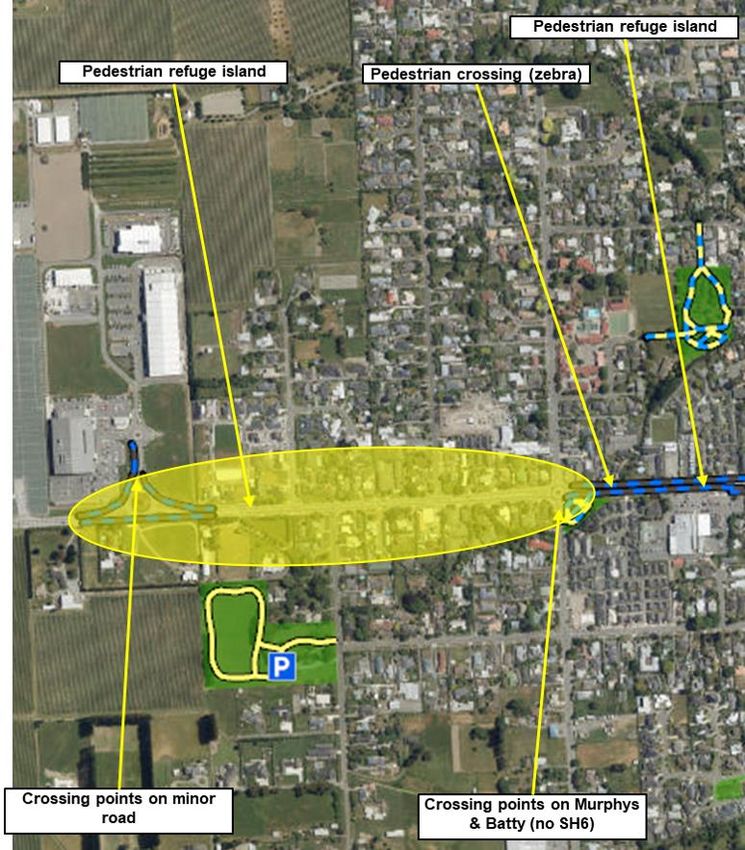
Figure 2-2: Pedestrian crossings on Middle Renwick Road
The local pedestrian network generally provides good access around the community, with the main
road and local streets having footpaths on both sides. There are some crossing points provided
relatively close to the roundabout intersections and there is one mid-block pedestrian island close to
the western end. The crossings on the south and east approaches are well back from the
intersection and most pedestrians are likely to cross on their desire line without the assistance of a
formal crossing facility. There are no crossing facilities between Rose Street and Battys Road as
shown in Figure 2-2.
3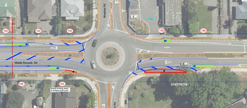
Middle Renwick Road, Blenheim – Proposed cycle
                                                                                           facilities

2.3           Cycle facilities and demand
Figure 2-3 shows an extract from the Marlborough District Council GIS page that illustrates the cycle
network in this area of Blenheim.
This shows that there are gaps in the network along Middle Renwick Road. On-road cycle lanes are
provided to the east of Battys Road, and there are some on and off-road facilities at the new
SH6/Westwood Avenue roundabout. There are off-road facilities through some reserves and to the
southeast is the Taylor River Reserve and Shared Pathway. The off-road paths are shown as blue and
yellow dashed lines in Figure 2-3.

    Figure 2-3: Cycle facilities within and around Middle Renwick Road (Source: Marlborough District Council)

There is limited cycle count data available1. In this case the Strava heatmap can be used to highlight
the more popular routes. Figure 2-4 shows that, within the area, Middle Renwick Road, and Battys
Road are well used cycle routes.

                           Figure 2-4: Cycle usage on different streets (Source: Strava)
Adams Lane and the Taylor River Reserve shared paths are shown to be well used routes and
therefore, connections to these routes should be considered.

1
  Cycle counts were completed between 14 Nov - 8 Dec 2019, and show an average daily count of 26 cyclists,
with a peak of 46 cyclists in one day. The count site suggests that these are cyclists leaving Blenheim, heading
towards Woodbourne and Renwick.
                                                       4                      Marlborough District Council
                                                                                  and Marlborough Roads
Middle Renwick Road, Blenheim – Proposed cycle facilities
2.4 Public transport & School buses
For people wanting to travel by public transport to the Springlands area, there are two routes that
use Middle Renwick Road.
Figure 2-5: Public transport routes using Middle Renwick Road (Source: Marlborough District Council)
Whilst on-road cyclists would be sharing the carriageway with buses, there are no bus stops in this
section of Middle Renwick Road.
2.5 General traffic demand
Middle Renwick Road is part of the State Highway Network and as such is classified as a regional
route (SH1 is a national route). It is a two-lane road with a flush median and parking lanes (total
carriageway width varies but is approximately 13.5 m).
Figure 2-6: One Network Road Classification
There are three side roads that connect onto Middle Renwick Road, all of which are classified as
access roads. Westwood Avenue at the western end is unclassified and maybe a private road
servicing the new development only, until any future connections are made. At the eastern end
Battys Road and Murphys Road which connect at the roundabout are classified as arterial (Battys)
and primary collector (Murphys).
There is permanent traffic counter located on SH6 at the Springlands Shopping Centre. Although not
directly on Middle Renwick Road, the flow profile is considered applicable. The data provided by
Waka Kotahi shows that in general SH6 carries an average of 15,000 vehicles per day (VPD). There
are peak volumes occurring in April with the wine harvest and a summer build up to Christmas,
starting in November.
This can be seen on the day rolling average chart, provided in Appendix A.
April around 16,000 VPD
November to Christmas around 16,000 - 18,000 VPD
5Middle Renwick Road, Blenheim – Proposed cycle
facilities
There is around 9-10% Heavy Goods Vehicles (HGV’s) on this route. Data extracted from the One
Network Road Classification and Mobile Roads shows that side roads such as Murphys Road and
Battys Road carry around 3,000 VPD with 6% of the traffic comprising heavy goods vehicles.
In summary, Middle Renwick Road is an arterial road that carries higher volumes of traffic with a
large proportion of HGV’s, it is a bus route and a well-used cycle route.
2.6 Traffic speeds
The actual sign posted speed for this section of Middle Renwick Road is 50 km/h. The speed limit
changes from 50 km/h to 100 km/h to the west of the Westwood Avenue.
Data extracted from NZTA’s “MegaMap” risk management database (based on TomTom data)
illustrates that mean operating speed on SH6 is at or above the posted speed limit sign particularly in
the western section of the study area. The safe and appropriate speed is shown to be 50 km/h
however, the section immediately east of Westwood Avenue is still showing the previous 100 km/h
safe and appropriate speed which presumably predates the Westwood development.
Figure 2-7: Mean Operating Speed and Safe & Appropriate Speed (source: MegaMap)
Any proposals to include cycle lanes should consider addressing the higher speeds along this section
of the route to ensure any active user facilities are more attractive to those traveling by bicycle or on
foot.
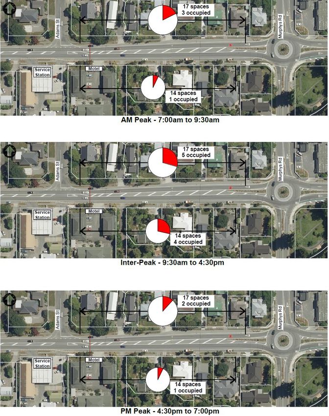
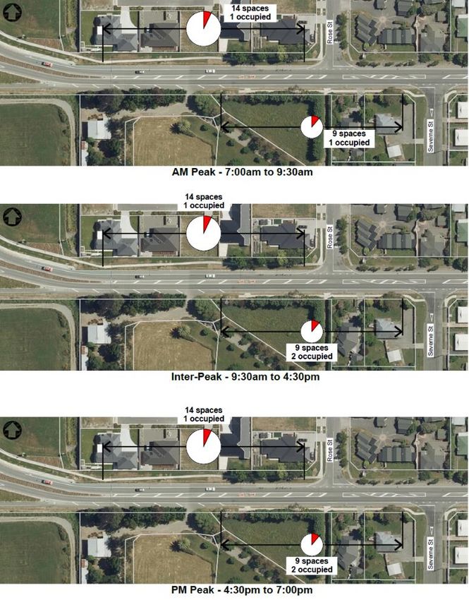
2.7 Parking
On-street parking is restricted along Middle Renwick Road by marked no stopping lines. Parking
occupancy data has been provided by Marlborough District Council to indicate the parking capacity
and occupancy. There are six separate parking zones (see reference Key in Table 2-1) that were
surveyed for parking occupancy, as shown in Figure 2-8.
6 Marlborough District Council
and Marlborough RoadsMiddle Renwick Road, Blenheim – Proposed cycle facilities
Figure 2-8: Parking survey zone locations
A weekday survey between 7:00 am to 7:00 pm (12 hours) on 24th June 2020 captured the parking
demand. As shown in Table 2-1 the weekday demand is low with only 8 vehicles recorded in the 56
spaces available on the northside and 37 spaces available on the south side.
A weekend survey between 7:00 am to 7:00 pm (12 hours) on 11th July 2020 also showed that
parking demands from Westwood Avenue to Battys Road roundabout are overall low with 8 vehicles
also recorded in the 93 spaces available.
This survey indicates the parking capacity for at least 8 vehicles is required to accommodate the
expected parking demand.
Table 2-1: Parking occupancy results
Weekday Weekend
Highest Max. % Highest Max. %
Street Key Side From To Capacity
Occupancy Occupied Occupancy Occupied
15 Murphys Adams 17 5 29.4% 2 11.8%
North side
17 Adams Rose 25 2 8.0% 1 8.0%
Middle Renwick Road (SH6)
19 Rose Westwood 14 1 7.1% 1 7.1%
Opposite
8 Battys 14 4 28.6% 3 21.4%
Adams
South side
Opposite
10 Severne 14 2 14.3% 1 7.1%
Adams
Westwood
12 Severne 9 2 22.2% 1 11.1%
Ave
Diagrams of parking capacity and occupancy can be found in Appendix B along with the raw data
used to inform Table 2-1.
Also noted and recorded during the parking survey, cars were parked on the side of the road that
were for sale and there was a trailer continuously parked for advertising overseas cruises. These
activities are not permitted on State Highways and providing indented parking is not considered
desirable to accommodate it. This is the reason that no indented carparking will be provided
towards Westwood Avenue. Photos of vehicles for sale and advertising trailers can be seen in
Appendix B, refer B.7.
7Middle Renwick Road, Blenheim – Proposed cycle
facilities
2.8 Existing street trees
There are cherry trees (Prunus sp. And Prunus Kanzan) planted along the sides of Middle Renwick
Road, see Figure 2-9. These trees provide aesthetic relief along the route, where there is no street
front tree planting in the residential or reserve properties.
Figure 2-9: Cherry trees along Middle Renwick Road
3 Crash data and risk
3.1 Risk Ratings
MegaMap provides several different comparative risk assessments of road sections throughout New
Zealand, based on crash data, traffic volumes, road features, and other attributes.
Figure 3-1: Collective Risk (Source: MegaMap)
Collective Risk is a measure of the total estimated DSI casualty equivalents per km for a road
segment. It is effectively a measure of the number of deaths and serious injuries per km that can be
expected on a road segment over the next five years. MegaMap does not identify any section on the
8 Marlborough District Council
and Marlborough RoadsMiddle Renwick Road, Blenheim – Proposed cycle facilities
corridor in the study area that have a “high” collective risk in terms of safety as shown in Figure 3-1.
The section that has the highest risk (medium) is from Severne Street to the Westwood Avenue
roundabout and beyond.
Figure 3-2: Personal risk (Source: MegaMap)
Personal Risk is a measure of the risk of an individual dying or being seriously injured on a road
corridor. It is calculated by dividing Collective Risk by traffic volume exposure. The whole section of
Middle Renwick Road is identified with a Low-Medium personal risk, see Figure 3-2.
Another MegaMap risk assessment tool is the Infrastructure Risk Rating (IRR) which includes, land
use, road stereotype, alignment, AADT, Intersection density, lane and shoulder width, roadside
hazards and access density. The IRR adopts a (5) band risk rating and Middle Renwick Road is rated
Low-Medium, see Figure 3-3
Figure 3-3: Infrastructure Risk Rating IRR (Source: MegaMap)
3.2 Crash data
All reported crashes along the Middle Renwick Road section were retrieved from NZTA’s Crash
Analysis System (CAS) for the five full years from 2015 to 2019 as shown in Figure 3-4. There were no
pedestrian crashes recorded along the subject route.
9Middle Renwick Road, Blenheim – Proposed cycle
facilities
Figure 3-4: All road user crashes
As can be seen in Figure 3-4, the Battys Murphys roundabout including approaches and departures
has 16 crashes recorded. This roundabout is where all the cyclist crashes occurred, see Figure 3-5.
Figure 3-5: Vulnerable road user crashes (Battys/Murphys Roundabout)
Of the 16 crashes at the SH6/Battys/Murphys roundabout, 6 crashes involved vulnerable road users
i.e. cyclists. For details of the roundabout crashes see C.2
These included crashes resulting in (1) serious injury, (4) minor injuries and (1) non-injury.
The serious injury crash involved a cyclist riding on the footpath on the southeast corner of the
roundabout heading towards the zebra crossing with two young children riding to school. The cyclist
failed to see a low sign due to sun strike and collided with underside of the sign.
Two minor injury crashes and the non-injury crash have occurred where drivers have entered the
roundabout (Battys Road x 2 and Middle Renwick Road x1) and failed to give-way to cyclists
travelling around the roundabout.
One crash recorded as a minor injury was a result of a cyclist failing to see a motorcycle travelling
behind a car on the circulatory carriageway. The cyclist exited Murphys Road into the roundabout,
subsequently the motorcyclist applied the brake to avoid the cyclist and fell off their motorcycle.
The remaining crash occurred on the west approach to the roundabout. A driver in a long queue
extending back from the roundabout has indicated to turn left into a driveway and has failed to
notice the cyclist on their left, travelling east towards the roundabout.
The road user crash data is provided in Appendix C.
3.3 Near miss data
Marlborough District Council has a repository for recording public reports od near miss crashes.
There has only been the single near miss crash recorded which can be seen in Appendix C.4
10 Marlborough District Council
and Marlborough RoadsMiddle Renwick Road, Blenheim – Proposed cycle facilities
4 Strategic Context
The strategic context of providing a buffered cycle lane facility along Middle Renwick Road fits within
the policy and planning is described in Appendix D. The facility is specifically designed to
accommodate to more confident rider which is appropriate for this route.
As presented in Section 7, see Figure 7-2, the provision of separated riding facilities for the
interested but concerned riders is planned for other surrounding parts of the network. These future
facilities can connect to the shared path of this project.
5 Target user
5.1 Enthused and confident
A review of the context of the area and the characteristics of the street, in addition to a review of
the strategy, the target user for Middle Renwick Road is the enthused and confident, and the more
confident riders within the interested but concerned users group, because in summary:
The street is an arterial vehicle route with high volumes (over 12,000 VPD). It carries over
5% Heavy Goods Vehicles due to the strategic route status. This is where HGV’s should be
and not on the local road network.
There are frequent driveways including high volume driveways at businesses.
Is a well-used cycle route, likely to be used by confident cyclists.
Is a bus route, althoughthere are no bus stops in this section.
Has inconsistent road widths and cross-sections.
Has limited pedestrians crossings.
Has intersections including dual entry roundabouts that are unfavourable for journeys by
bicycle
5.2 Interested but concerned
The route is not considered desirable or suitable for the interested but concerned users, because in
summary;
It would need significant infrastructure changes to the corridor to make it suitable for
interested but concerned users and yet it would still have the issues of road noise, driveway
risks etc, that can make riding unpleasant and include higher risks.
It’s not the sort of road environment interested but concerned users typically want to ride
along.
Although the target user of the route is expected to stay on-road using the buffered cycle lanes,
there are shorter links along the route where interested but concerned riders may want to ride. For
example the future link between Severne Street and Westwood Avenue. There is also a possible
future link betyween Springlands School / Murphys Road and Severne Street on a shared off-road
path along Middle Renwick Road.
Based on the target user analysis the preferred treatment along Middle Renwick Road is on-road
buffered cycle lanes with shorter sections of off-road shared path provided to complete links for the
interested but concerned riders.
11Middle Renwick Road, Blenheim – Proposed cycle
facilities
6 Stakeholder Engagement
Microsoft Teams meetings were held between Warren Lloyd (ViaStrada) and Braden Prideaux
(Marlborough District Council) on 5 and 20 May for project scope discussion, project updates and
parking survey briefing.
Microsoft Teams meetings was held between the ViaStrada project team, Braden Prideaux, and
Andy High of Waka Kotahi NZ Transport Agency on 12 June to discuss project issues including:
cross sections,
preferred option rationale (safety Vs efficiency Vs parking)
MCA criteria
treatments of key intersections
Marlborough District Council and Waka Kotahi staff have provided feedback on the three options
included in this report, see Section 9. To date, Waka Kotahi support option 2 that retains the flush
median and some indented parking where there is identified demand.
Public consultation should be considered in the future to ensure residents and the wider community
have an opportunity to have their say on the proposed cycle lanes.
7 Project outcomes
Considering all the background data above, and in considering good design principles for design
cycle facilities, the following principles are recommended:
• Provide for existing users but with a focus on encouraging new users too (more confident
riders within the Interested but Concerned group). Among this group would be residents
and workers, people who are young and old, and may include those with assisted (e-
)bicycles.
• Traffic speed and volume management are just as crucial as providing specific cycle facilities
to improve the attractiveness and reduce stress when riding
• Address connections to side streets that may provide access to shopping facilities, schools
and parks.
Five core design principles provide a blueprint for good outcomes for bicycle journeys and, in a
broader sense, the concept of placemaking for neighbourhoods.
Figure 7-1: Core design principles
Consistency in treatments and application help to create a network for people to move around by
bicycle that is easy to understand and for users to navigate their way.
Whilst the study area focuses on the section of Middle Renwick Road from Westwood Avenue to
Battys Road/Murphys Road roundabout, it is important to consider the wider network of routes and
facilities for overall network legibility. Whilst the cycle facility here is for a certain target user, some
12 Marlborough District Council
and Marlborough RoadsMiddle Renwick Road, Blenheim – Proposed cycle facilities
sections of the overall corridor may not work for the Interested but Concerned user and so parallel
shared path routes may be more suitable for this rider.
Figure 7-2 shows an overall approach for links for different users of the network. As a
neighbourhood facility the retail offering at Westwood Avenue should be accessible for all residents
in proximity so additional measures may be required to allow less confident riders the option to ride
to the supermarket.
Figure 7-2: MDC Cycle Strategy with further possible routes for less confident riders
Note that the possible interested but concerned cycle routes shown along Middle Renwick Road in
Figure 7-2 relate to off-road shared path options and does not include any on-road options, due to
high traffic volume and speed.
Because of the traffic environment, buffered cycle lanes are proposed for the more confident on-
road cyclists, with short sections of off-road shared path provided for less confident / experienced
cyclists.
8 Buffered cycle lanes
The general design approach incorporates the thinking used to inform the proposed draft Waka
Kotahi technical note for publication on buffered cycle lanes. ViaStrada has used their experience
and expertise to collaborate in the development of the technical note and bring this knowledge to
the Middle Renwick Road project. For the latest thinking on buffered cycle lanes, see Appendix E.3.1.
Using the existing data, traffic information, and the principles identified in Section 5 it is proposed
that buffered cycle lanes be introduced along Middle Renwick Road for confident on-road cyclists.
Buffered cycle lanes comprise a conventional on-road cycle lane with a marked buffer between the
cycle lane and moving traffic lane and/or parking lane. The use of the buffer can encourage people
riding a bicycle to travel outside the door opening zone but can also increase the perception of
safety by having something between the rider and the traffic lane. They also make it easier for
drivers to pass cyclists at a safer distance.
The dimensions in Table 8-1 inform the possible combinations of elements for the different cross-
section widths. In terms of overall design, there is potential to increase road user risk if all absolute
minimums are provided on the cross-section.
Middle Renwick Road measures approximately 13.5 m from kerb to kerb and currently comprises
parking lanes, traffic lanes and a flush median.
13Middle Renwick Road, Blenheim – Proposed cycle
facilities
Table 8-1: Basic parameters for cross-section design
9 Option development
Based on the existing conditions, crash history, strategic context, and the target user cyclist, three
options have been developed for consideration. In all options it is proposed to incorporate a shared
path from the Westwood Avenue roundabout to Severne Street to facilitate access to a local street
that some riders may feel more confident to use than travelling along Middle Renwick Road.
The options considered by the project team are included in Appendix F.
9.1.1 Option 1
Option 1 provides buffered bike lanes within the existing kerb to kerb width and retains the flush
median. It is not possible to accommodate on-street parking also with these cross-section elements.
This option will be relatively low cost as it requires minor removal of existing road markings and
many of the new markings can align with the existing.
9.1.2 Option 2
Option 2 provides buffered bike lanes within the existing kerb to kerb width and retains the flush
median. The flush median is propsoed to be reduced in width from Option 1 and some on-street car
parking can be provided with indented parking bays with some localised widening.
This option will be the highest cost as it requires kerb and channel works associated with the
indented parking and removal of much of the existing road markings as not many of the new
markings align with the existing.
One of the consequences of option 2 is that providing indented parking results in having to remove
some of the existing street trees.
9.1.3 Option 3
Option 3 provides buffered bike lanes within the existing kerb to kerb width but it is proposed to
remove the flush median to accommodate on-street car parking within the existing kerb to kerb
width. This results in parking be provided, without the cost of constructing indented parking bays.
14 Marlborough District Council
and Marlborough RoadsMiddle Renwick Road, Blenheim – Proposed cycle facilities
This option will be relatively low cost as it requires removal of existing road markings and some of
the new markings align with the existing.
10 Multi-criteria analysis
The Multi-criteria analysis looks at all the different considerations for each different option,
including
design context
community and stakeholder interest
project costs and programme risk
As discussed in Section 7 considering good design principles for designing cycle facilities, design
context considers safety, comfort, directness, coherence and attractiveness.
The summary tables are provided below with the overall MCA table provided in Appendix G. The
MCA was undertaken for two locations within Section 1, to reflect the different environment and
context. These are shown below. Location 1A extends from the Westwood Avenue roundabout to
Severne Street and 1B extends from Rose Street to the Battys/Murphys roundabout.
Figure 10-1: Locations for MCA
15Middle Renwick Road, Blenheim – Proposed cycle
facilities
Table 10-1: Design Context
Design Context (55%)
Attractiveness
Coherence &
Safety Comfort Directness and Social
Connectivity
Safety
* users * Time and
experience distance to
* Safety along *perceptions of travel
route for users risk; * Good match
* Easy to
* Relative conflict *impacts from to:
recognise * Cycling
with other road other traffic ***local schools
route experience and
users: pedestrians; noise; CO2 ***shops
* Limited amenity.
residents; traffic ***parks
*cycleway changing of * Lighting levels
* Higher volume ***other public
width, level of facility types
driveways/turning spaces/buildings
protection, * Few
vehicles
obstacles, complicated
gradient manoeuvres
Location 1a & 1b
Option 1
Option 2
Option 3
Community and stakeholder interests appraise factors that look at the effects on those directly
affected, or overall effects on the transport network.
Table 10-2: Community and stakeholder Interest
Community & Stakeholder Interest (30%)
Business/
Residents Network Effects
Schools
* Effect of changes to arterial corridor?
* Effects on access * Access to properties
* Public transport routes affected?
* Changes to on-street * Changes to on-street
* Effect on operational & maintenance
parking and loading parking
costs? (waste collection etc)
Location 1a
Option 1
Option 2
Option 3 XX
Location 1b
Option 1 - X
Option 2 -
Option 3 - XX
Option 3 scored poorly in the network effects as it proposes the removal of the flush median. The
flush median allows vehicles to wait clear of through traffic om the State Highway so if it was
removed, through traffic would need to wait behind turning vehicles. If drivers choose not to wait
16 Marlborough District Council
and Marlborough RoadsMiddle Renwick Road, Blenheim – Proposed cycle facilities
behind a turning vehicle, they may use the cycle lane space to pass and could come into conflict with
people riding in the facility and therefore affect safety of users. This is also the case where a drier
may stop suddenly to make a turn and a following driver may not have time to react resulting in a
rear end collision.
Lastly, project costs and programme risks look at the different costs and issues that could delay the
implementation of the scheme. Collectively these factors assist the project team in determining a
preferred option to discuss with the community.
Table 10-3: Project Cost and Programme Risk
Project Costs and Programme Risks 25%
Cost Risks Programme Risks
Increased costs due to:
Programme delays due to:
* Physical works (K&C)
*Land/property acquisition
*Property purchase
*Legal processes - consents
*Complicated facilities
(Timing Risk)
(Budget Risk)
Location 1a &
1b
Option 1
Option 2 X
Option 3
The preferred option includes the buffered cycle lanes, the shared path link between Westwood
Avenue and Severne Street, some indented car parking to accommodate the demand that were
identified in the on-street parking survey.
11 Preferred Option
It is proposed to implement buffered bicycle lanes, a continuous 2.5 – 2.8 m wide flush median
(width varies to achieve consistent traffic lane widths and tie into existing right turn bays) and some
indented parking along Middle Renwick Road from Westwood Avenue to the Battys Road/Murphys
Road roundabout. This completes a gap in the on-road cycle network and improves the road
environment for people travelling on-road by bicycle.
There are also two short sections of off-road shared path proposed for the interested but concerned
riders that may not want to ride on Middle Renwick Road.
The proposed layout plan is included in Section 11.3 and plans of the revised option 2 following RCA
feedback can be viewed in Appendix H.
17Middle Renwick Road, Blenheim – Proposed cycle
facilities
11.1 Parking
There are 12 parking spaces proposed along the north side and 13 parking spaces proposed along
the south side of Middle Renwick Road. The provision of 25 spaces along this section of Middle
Renwick road exceeds the measured parking demand of 8 cars parked during the weekday and
weekend surveys undertaken by Marlborough District Council earlier in 2020.
Table 11-1: Parking provision
Weekday Weekend
Parking
Street Zone Side From To Capacity Highest Highest
provision
Occupancy Occupancy
15 Murphys Adams 17 5 2 7
North side
Middle Renwick Road (SH6)
17 Adams Rose 25 2 1 5
19 Rose Westwood 14 1* 1* 0
Opposite
8 Battys 14 4 3 6
Adams
South side
Opposite
10 Severne 14 2 1 7
Adams
Westwood
12 Severne 9 2^ 1^ 0
Ave
* Trailer parked all day advertising travel
^ Cars parked all day that were advertised ‘for sale’
The removal of parking from Middle Renwick Road will remove the lane marking ambiguity for all
road users. As seen in Figure 11-1, an on-road cyclist departing from the Westwood Ave roundabout,
in the cycle lane is confronted by parked vehicles, in the green coloured and marked cycle lane.
However, there are no more cycle symbols marked along this lane and some people feel comfortable
parking here, although many park here for business, see appendix B.7.
Figure 11-1: Parking in cycle lane or cycling in parking lane
18 Marlborough District Council
and Marlborough RoadsMiddle Renwick Road, Blenheim – Proposed cycle facilities
11.2 Street trees to be removed
This option does require the removal of 5 street trees and care has been taken to maximise parking
provision while minimising tree removal. Indented parking has been provided where trees have been
identified with an average ‘environmental condition’2. The parking is to be provided in blocks where
more cars can fit into a space provided.
Table 11-2: Summary of indented parking and street trees
Indented No of No of Environmental
Species Tree Condition
parking parks trees Condition
North side 5 2 Prunus sp. All Good All Average
South side 7 3 Prunus Kanzan 1 Good, 2 Average All Average
Figure 11-2 shows the three cherry trees along the south side of Middle Renwick Road that would be
removed with option 2. These three trees are dwarfed by the trees in the adjacent property and
their removal will have minimal impact on the street scape.
Figure 11-2: Cherry trees along south side of Middle Renwick Road
2
Information provided by Marlborough District Council
19Middle Renwick Road, Blenheim – Proposed cycle
facilities
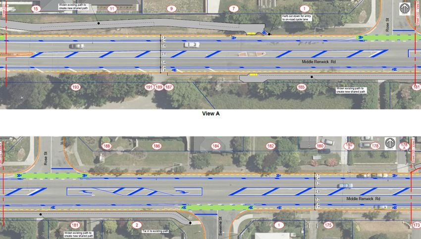
11.3 Proposed layout
Figure 11-3: Westwood Avenue roundabout
Figure 11-4: Mid-block section from Westwood Avenue
20 Marlborough District Council
and Marlborough RoadsMiddle Renwick Road, Blenheim – Proposed cycle facilities
Figure 11-5: Mid-block section to Battys Murphys roundabout
Figure 11-6: Battys Murphys roundabout
21Middle Renwick Road, Blenheim – Proposed cycle
facilities
11.4 Proposed cross-sections
The proposed cross-sections are shown below.
Figure 11-7: Proposed cross-section for where there is no on-street parking
Figure 11-8: Proposed cross-section for where there is indented parking
22 Marlborough District Council
and Marlborough RoadsMiddle Renwick Road, Blenheim – Proposed cycle facilities
11.5 Next Steps
11.5.1 Safety audits
It is best practice to have scheme proposals assessed through a Safety Audit. This should occur prior
to public consultation.
11.5.2 Public consultation
It is recommended that the plans be provided to the community for public consultation.
12 Services and rough order costs
Details about services are provided in Appendix I. The have been services identified that will require
surface modification, these are included in ancillary costs and identified on the plans. The rough
order cost (ROC) contingency is 25% or $80,000 for unexpected discovery.
The overall cost to deliver the project is estimated to be under $460,000 as shown in Table 12-1. This
amount does not include professional fees for project management, contract administration and
supervision, as some of these services may be provided in-house.
Table 12-1: Summary of costs
Middle Renwick Road Project: 1124-10
Cycle facilities Date: 1/08/2020
Scheme Design ROC Estimate Prepared: JA
Reviewed: WL
Construction costs
Item Amount
Preliminary & General $ 10,000
Shared path & cycle path (All 75mm conc) $ 58,773
Kerb $ 23,060
Road $ 17,500
Parking indents inc footpath $ 63,750
Road Marking $ 77,100
Traffic Signs $ 7,400
Landscape $ 12,425
Ancillary Costs $ 9,900
Traffic management $ 38,100
Construction Cost Total $ 318,100
Contingency 25% $ 79,600
Construction Estimate $ 397,700
Other fees
Item
General project management (3%) $ 9,600
Professional fees (safety audit) $ 8,000
Contract administration & supervision (14%) $ 44,600
Total $ 62,200
TOTAL PROJECT ESTIMATE $ 459,900
The more detailed breakdown of the ROC is included in Appendix J.
23Middle Renwick Road, Blenheim – Proposed cycle
facilities
13 Additional project considerations
In developing options for this section of road, there are further improvements that could be made to
improve connectivity an accessibility that are outside of the scope but could contribute to improved
access and mobility options around the neighbourhood. These are included in Appendix L.
14 Appendices
The following information in these appendices support and validates the buffered cycle lane option
along this section of Middle Renwick Road.
24 Marlborough District Council
and Marlborough RoadsMiddle Renwick Road, Blenheim – Proposed cycle facilities
Appendix A Traffic Volumes from Waka Kotahi
Figure 14-1: Middle Renwick Road Daily and 7 day rolling average traffic volumes
25Middle Renwick Road, Blenheim – Proposed cycle
facilities
Appendix B Parking
The parking results from the Councils parking survey for the Middle Renwick Road study are is
broken into 3 Zones for presentation in this appendix.
B.1 Weekday parking - Zone 1
Figure 14-2: Section 1 Parking occupancy
The survey for Zone 1 at the western end of the study area showed that there was no change
throughout the survey in terms of demand, with only two of the 23 spaces being used throughout
the day. It is noted that this higher than the occupancy shown on the LINZ aerial photograph below
(taken summer 2017/18 at an unknown time of day) with no cars parked in the 23 spaces available.
26 Marlborough District Council
and Marlborough RoadsMiddle Renwick Road, Blenheim – Proposed cycle facilities
B.2 Weekday parking - Zone 2
Figure 14-3: Section 2 Parking occupancy
The survey for Zone 2 to the east of Rose Street showed that the greatest demand for parking in this
location was during the interpeak when 4 of the 39 spaces were being used. It is noted that this is
lower than the occupancy shown on the LINZ aerial photograph below (taken summer 2017/18 at an
unknown time of day) with 10 cars parked in the 39 spaces available.
27Middle Renwick Road, Blenheim – Proposed cycle
facilities
B.3 Weekday parking Zone 3
Figure 14-4: Section 3 Parking occupancy
The survey for Zone 3 at the eastern end of the study area showed that the greatest demand for
parking in this location was also during the interpeak when 9 of the 31 spaces were being used. It is
noted that this higher than the occupancy shown on the LINZ aerial photograph below (taken
summer 2017/18 at an unknown time of day) with 4 cars parked in the 31 spaces available.
28 Marlborough District Council
and Marlborough RoadsMiddle Renwick Road, Blenheim – Proposed cycle facilities
B.4 Weekend parking All Zones
14-5: All Sections - Parking occupancy
29B.5
Highest Max. %
Street KEY From To Capacity 7.00 7.30 8.00 8.30 9.00 9.30 10.00 10.30 11.00 11.30 12.00 12.30 1.00 1.30 2.00 2.30 3.00 3.30 4.00 4.30 5.00 5.30 6.00 6.30
Occupency Occupied
MRR (SH6) 15 Murphys Adams 17 5 29.4% 3 3 3 3 3 3 5 5 4 4 4 4 4 4 3 4 4 4 3 2 0 1 2 2
North side
MRR (SH6) 17 Adams Rose 25 2 8.0% 0 0 0 0 0 1 0 0 2 1 2 0 0 0 0 0 0 0 0 0 0 1 1 1
MRR (SH6) 19 Rose Westwood 14 1 7.1% 1 1 1 1 1 1 1 1 1 1 1 1 1 1 1 1 1 1 1 1 1 T T T
12 10 17 14 30 17 21 18 25 25 28 20 19 19 18 18 23 15 10 10 9 13 13 11
Weekday parking raw data
30
Highest Max. %
Street KEY From To Capacity 7.00 7.30 8.00 8.30 9.00 9.30 10.00 10.30 11.00 11.30 12.00 12.30 1.00 1.30 2.00 2.30 3.00 3.30 4.00 4.30 5.00 5.30 6.00 6.30
Occupency Occupied
Opposite
MRR (SH6) 8 Battys 14 4 28.6% 0 1 0 0 1 1 1 2 2 3 2 2 4 3 3 1 1 1 1 1 0 1 1 1
Adams
Opposite
South side
MRR (SH6) 10 Severne 14 2 14.3% 0 0 0 0 2 2 1 1 2 2 2 0 0 0 0 1 1 1 1 1 0 0 0 0
Adams
MRR (SH6) 12 Severne Westwood Ave 9 2 22.2% 0 0 0 0 1 1 1 2 2 2 2 1 1 1 1 1 0 1 1 2 0 1 0 0
7 8 7 9 15 13 24 26 29 25 22 19 27 25 24 23 33 11 14 15 9 11 8 8
Middle Renwick Road, Blenheim – Proposed cycle
facilities
Marlborough District Council
and Marlborough RoadsB.6
Highest Max. %
Street Key From To Capacity 7.00 7.30 8.00 8.30 9.00 9.30 10.00 10.30 11.00 11.30 12.00 12.30 1.00 1.30 2.00 2.30 3.00 3.30 4.00 4.30 5.00 5.30 6.00 6.30
Occupency Occupied
MRR (SH6) 15 Murphys Adams 17 2 11.8% 0 0 0 0 0 1 1 1 1 0 0 0 0 0 0 0 2 2 2 1 1 1 1 1
MRR (SH6) 17 Adams Rose
North side
25 1 8.0% 1 1 1 1 1 1 1 1 1 1 1 0 1 0 0 1 0 1 1 0 0 0 0 0
MRR (SH6) 19 Rose Westwood 14 1 7.1% 1 1 1 1 1 1 1 1 1 1 1 0 1 1 1 1 1 1 1 1 1 1 1 1
11 11 7 13 13 15 15 14 13 15 13 12 13 12 10 11 13 12 11 10 10 12 12 11
Weekend parking raw data
31
Middle Renwick Road, Blenheim – Proposed cycle facilities
Highest Max. %
Street Key From To Capacity 7.00 7.30 8.00 8.30 9.00 9.30 10.00 10.30 11.00 11.30 12.00 12.30 1.00 1.30 2.00 2.30 3.00 3.30 4.00 4.30 5.00 5.30 6.00 6.30
Occupency Occupied
MRR (SH6) 8 Battys Opposite Adams 14 3 21.4% 0 0 0 0 0 1 1 3 2 1 1 1 1 1 0 2 0 0 0 0 0 0 3 2
MRR (SH6) 10 Opposite Adams Severne
South side
14 1 7.1% 1 0 0 0 0 0 0 0 0 0 0 0 0 0 0 0 0 0 0 0 0 0 0 0
MRR (SH6) 12 Severne Westwood Ave 9 1 11.1% 0 0 0 0 0 0 0 0 0 0 0 0 0 0 0 0 0 0 0 0 0 0 0 1
8 7 7 7 8 10 10 12 9 8 7 5 6 6 6 7 9 5 5 5 5 5 8 8Middle Renwick Road, Blenheim – Proposed cycle
facilities
B.7 Photos of illegal parking and advertising activity
Figure 14-6: Trailer continuously parked in this location
One of the key safety concerns is that the trailer parked in this location forces Blenheim bound
cyclists into live traffic lane. The fact that the advertiser is trying to divert the driver’s attention away
from the driving task to read their sign is also a road user safety concern.
Figure 14-7: Vehicles for sale along Middle Renwick Road
Again, the advertiser is trying to divert passing driver’s attention away from the driving task to notice
their vehicle for sale is a road user safety concern.
32 Marlborough District Council
and Marlborough RoadsMiddle Renwick Road, Blenheim – Proposed cycle facilities
Appendix C CAS crash data
C.1 Vulnerable user crashes
Table 14-1: CAS vulnerable road user crash data
Natural Light
Crash Road
Side Road
Direction
Weather
Distance
Surface
Minor
Time
Fatal
Date
Day
Ser
ID
Description of events Crash factors
Car/Wagon1 DIRN on 006-0000
CAR/WAGON1, failed to give
006-0000 I BATTYS 201958520 27/01/2019 Sun 11:00 hit Cyclist2 (Age 0) crossing at Dry Bright sun Fine 0 0 0
way at priority traffic control
right angle from right
Motorcycle1 EDB on MIDDLE CYCLE2, did not check/notice
RENWICK ROAD, SPRINGLANDS, another party from other dirn,
006-0000 I MURPHYS 201956539 20/05/2019 Mon 16:10 MARLBOROUGH lost control failed to give way at priority Dry Bright sun Fine 0 0 1
turning right but did not leave traffic control MOTORCYCLE1,
the road sudden action
Car/Wagon1 NDB on Battys
CAR/WAGON1, failed to give
BATTYS I SH 6 201713232 23/04/2017 Sun 17:26 road hit Cyclist2 (Age 26) Dry Twilight Fine 0 0 1
way at priority traffic control
crossing at right angle from right
CAR/WAGON1, alcohol test
Car/Wagon1 NDB on Murphys below limit, did not
BATTYS I SH 6 201819009 27/10/2018 Sat 12:46 Rd hit Cyclist2 (Age 46) crossing check/notice another party Dry Overcast Fine 0 0 1
at right angle from right from other dirn, failed to give
way at priority traffic control
CYCLE1, driver dazzled, failed to
notice signs, wrong way in one
Cycle1 EDB on Middle Renwick
way street, motorway or
SH 6 60 E BATTYS 201812918 20/03/2018 Tue 8:40 Road hit obstruction, Cycle1 hit Dry Bright sun Null 0 1 0
roundabou, ENV: visibility
non specific traffic sign
limited by traffic sign, dazzling
sun
Cycle1 EDB on SH 6 sideswiped CYCLE1, overtaking on left
SH 6 40 W MURPHYS 201513376 8/05/2015 Fri 17:00 by SUV2 EDB on SH 6 turning without due care, ENV: entering Dry Twilight Fine 0 0 1
left or leaving private house / farm
Note; that this data is for the whole route, but all of the cycle crashes occurred at or on the
approaches and or departures of the Battys / Murphys roundabout.
33Middle Renwick Road, Blenheim – Proposed cycle
facilities
C.2 Battys / Murphys roundabout all road users’ crashes
Table 14-2: CAS all road user crash data (Battys / Murphys roundabout)
Surface condition
CODED CRASH ID
Natural light
Day of week
Crash road
Side road
Direction
Weather
Distance
Severe
Minor
Fatal
Time
Date
ID
Description of events Crash factors
Car/Wagon1 DIRN on
CAR/WAGON1, failed to
006-0000 hit Cyclist2
1193327 006-0000 I BATTYS 201958520 27/01/2019 Sun 11:00 give way at priority Dry Bright sun Fine 0 0 0
(Age 0) crossing at right
traffic control
angle from right
Unknown1 DIRN on 006-
UNKNOWN1, failed to
0000 hit Car/Wagon2
1187504 006-0000 I BATTYS 201897999 27/08/2018 Mon 7:50 give way at priority Dry Bright sun Fine 0 0 0
crossing at right angle
traffic control
from right
CYCLE2, did not
Motorcycle1 EDB on
check/notice another
MIDDLE RENWICK ROAD,
party from other dirn,
SPRINGLANDS,
1187684 006-0000 I MURPHYS 201956539 20/05/2019 Mon 16:10 failed to give way at Dry Bright sun Fine 0 0 1
MARLBOROUGH lost
priority traffic control
control turning right but
MOTORCYCLE1, sudden
did not leave the road
action
CAR/WAGON1, did not
Car/Wagon1 NDB on
check/notice another
Battys road hit
1139267 BATTYS I SH 6 201753159 7/11/2017 Tue 11:27 party from other dirn, Dry Bright sun Fine 0 0 0
Car/Wagon2 crossing at
failed to give way at
right angle from right
priority traffic control
CAR/WAGON1, alcohol
Car/Wagon1 NDB on test below limit, did not
Murphys Rd hit Cyclist2 check/notice another
1153632 BATTYS I SH 6 201819009 27/10/2018 Sat 12:46 Dry Overcast Fine 0 0 1
(Age 46) crossing at right party from other dirn,
angle from right failed to give way at
priority traffic control
Car/Wagon1 NDB on
CAR/WAGON1, failed to
Battys road hit Cyclist2
1108751 BATTYS I SH 6 201713232 23/04/2017 Sun 17:26 give way at priority Dry Twilight Fine 0 0 1
(Age 26) crossing at right
traffic control
angle from right
Motorcycle1 WDB on SH
6 hit obstruction, MOTORCYCLE1, speed on
1043906 SH 6 I BATTYS 201517983 23/11/2015 Mon 12:30 Dry Bright sun Fine 0 0 1
Motorcycle1 hit non straight
specific kerb
CAR/WAGON2, failed to
Car/Wagon1 WDB on SH
give way at priority
1079125 SH 6 I BATTYS 201630988 20/01/2016 Wed 6:54 6 hit Car/Wagon2 Dry Twilight Fine 0 0 0
traffic control, other
merging from the left
inattentive
CYCLE1, driver dazzled,
failed to notice signs,
Cycle1 EDB on Middle
wrong way in one way
Renwick Road hit
1147585 SH 6 60 E BATTYS 201812918 20/03/2018 Tue 8:40 street, motorway or Dry Bright sun Null 0 1 0
obstruction, Cycle1 hit
roundabou, ENV:
non specific traffic sign
visibility limited by traffic
sign, dazzling sun
Car/Wagon1 WDB on SH
CAR/WAGON1, following
1159214 SH 6 40 E BATTYS 201833454 15/02/2018 Thu 6 hit rear end of Van2 Dry Bright sun Fine 0 0 0
too closely
stop/slow for queue
Van1 EDB on SH 6 lost
control turning right,
VAN1, failed to notice
1165583 SH 6 40 W BATTYS 201839857 17/05/2018 Thu 20:05 Van1 hit non specific Dry Dark Fine 0 0 0
obstruction on roadway
traffic island, non specific
traffic sign
Car/Wagon1 WDB on
CAR/WAGON1, alcohol
Middle Renwick Road
test above limit or test
lost control; went off
1093149 SH 6 15 W BATTYS 201645226 12/08/2016 Fri 23:35 refused, over the speed Wet Dark Light rain 0 0 0
road to right,
limit, ENV: slippery road
Car/Wagon1 hit non
due to rain
specific fence
CYCLE1, overtaking on
Cycle1 EDB on SH 6
left without due care,
1039541 SH 6 40 W MURPHYS 201513376 8/05/2015 Fri 17:00 sideswiped by SUV2 EDB Dry Twilight Fine 0 0 1
ENV: entering or leaving
on SH 6 turning left
private house / farm
CAR/WAGON1,
Car/Wagon1 EDB on SH 6
emotionally upset/road
hit rear end of
1136416 SH 6 I MURPHYS 201750254 7/09/2017 Thu 16:20 rage, failed to notice car Dry Overcast Fine 0 0 0
Car/Wagon2 stop/slow
slowing,
for cross traffic
stopping/stationary
Van1 WDB on SH 6 hit
VAN1, failed to give way
1053536 SH 6 I MURPHYS 201538092 20/05/2015 Wed 7:20 Car/Wagon2 crossing at Dry Overcast Fine 0 0 0
at priority traffic control
right angle from right
Car/Wagon1 EDB on SH 6
CAR/WAGON1, failed to
hit rear end of Van2
1127402 SH 6 70 E MURPHYS 201741114 13/05/2017 Sat 8:20 notice car slowing, Dry Overcast Null 0 0 0
stop/slow for
stopping/stationary
PEDESTRIAN
Car/Wagon1 EDB on SH 6
CAR/WAGON1, failed to
hit rear end of
1157815 SH 6 50 W MURPHYS 201832046 26/01/2018 Fri 11:30 notice car slowing, Dry Bright sun Fine 0 0 0
Car/Wagon2 stop/slow
stopping/stationary
for queue
34 Marlborough District Council
and Marlborough RoadsYou can also read