MISSOURI STATE EAS PLAN - January 2017 - Missouri Broadcasters
←
→
Page content transcription
If your browser does not render page correctly, please read the page content below
MISSOURI
 STATE
EAS PLAN
  January 2017
Introduction:
         Missouri is home to six million residents. Therefore, it is possible for a great number of
people to be affected should an emergency occur. The best way to effectively manage an
emergency or a public threat is to be prepared. Timely information delivered to the public during
an eminent or ongoing emergency is critical. State law enforcement agencies along with all local
media outlets, and the National Weather Service have developed this plan to inform the public of
eminent danger and prevent harm. The State of Missouri’s EAS (Emergency Alerting System)
Plan has been developed to place emergency information and instructions in the hands of
Missouri residents in a timely manner. The public has access to all forms of media; however, the
FCC mandates that licensed broadcasters install and maintain emergency alerting equipment.
Licensed broadcasters include radio, television, cable television (including all forms of video over
IP), and the National Weather Service. These media outlets are required by the FCC to test
alerting equipment on a regular basis and perform exercises to remain familiar with its usage.
         This plan, first and foremost, instructs all media outlets in the proper use and provides
instructions to be prepared before disaster strikes.
        IPAWS (Integrated Public Alert Warning System) is an integral part of this plan and is
used throughout the United States. Using the CAP (Common Alerting Protocol) system
information can be disseminated via the internet to all media outlets and agencies within seconds.
IPAWS/CAP alerting insures all regions of the state of Missouri receive messages in a timely
manner.
        The Missouri EAS Plan must remain flexible and capable of change. Technology is
evolving at a rapid rate; therefore, new methods must be regularly examined and incorporated to
remain effective. The State Emergency Communications Committee will review this plan
annually to insure it is accurate and up to date.

                                                      i
Concurrences
The Missouri State Emergency Alert Plan is a joint development. Agencies involved are: The
Missouri Department of Public Safety, Missouri Broadcasters Association, Missouri Cable System
Operators, the Missouri State Emergency Communications Committee, and the National Weather
Service. We, the following concur with the plans outlined in this document.

_____________________                                           _______________
                                                                Date
Governor, State of Missouri

_____________________                                           _______________
                                                                Date
Director, Missouri Department of Public Safety

_____________________                                           _______________
Mark Gordon                                                     Date
President, CEO Missouri Broadcasters Assn.

_____________________                                           _______________
Bob Moore                                                       Date
Missouri State EAS Chairman

_____________________                                           _______________
James Kramper                                                   Date
National Weather Service, St. Louis, MO

_____________________                                           _______________
                                                                Date
Director, State Emergency Management Agency

_____________________                                           _______________
                                                                Date
Missouri State Highway Patrol

_____________________                                           _______________
                                                                Date
Deputy Director, Department of Public Safety
Acting Homeland Security Coordinator

                                                      ii
Table of Contents

Introduction ................................................................................................................................................... i
Concurrences................................................................................................................................................. ii
Purpose.......................................................................................................................................................... 1
Requirements ................................................................................................................................................ 2
FIPS Codes ................................................................................................................................................... 2
IPAWS/CAP ................................................................................................................................................ 2
      A: IPAWS Origination ........................................................................................................................... 2
      B: IPAWS National Test ........................................................................................................................ 2
      C: IPAWS State Test .............................................................................................................................. 2
      D: IPAWS State Emergency .................................................................................................................. 3
National Weather Service ............................................................................................................................. 4
Wireless Emergency Alerts (WEA) .............................................................................................................. 4
Social Media ................................................................................................................................................. 5
EAS Participant ............................................................................................................................................ 5
Primary Entry Point ...................................................................................................................................... 6
State Entry Point ........................................................................................................................................... 6
Local Primary................................................................................................................................................ 7
Local Operational Areas ............................................................................................................................... 7
Monitoring Sources....................................................................................................................................... 7
Dissemination of Information ....................................................................................................................... 8
Event Code Priority, Originators, Locations, EAS Logging ......................................................................... 9
Event Code Usage ....................................................................................................................................... 10
      A: Statewide ......................................................................................................................................... 10
      B: National Weather Service ................................................................................................................ 10
      C: Local Alerts ..................................................................................................................................... 39
                                                          (Table of Contents Continued)
Table of Appendices
Appendix A – Table of FIPS Codes ........................................................................................................... 40
Appendix B – IPAWS Infrastructure ......................................................................................................... 40
Appendix C – NOAA Weather Radio Information .................................................................................... 40
Appendix D – Local Primary Stations ....................................................................................................... 40
Appendix E – Local Operational Areas, Counties, Local Area Chairmen ................................................ 40
Appendix F – Monitoring Assignments ..................................................................................................... 40
Appendix G – National, State, Local Event Codes .................................................................................... 40
Appendix H – Sample Scripts .................................................................................................................... 40
A: State-Wide Emergency ................................................................................................................... 40
B: State-Wide Test .............................................................................................................................. 40
Appendix H – Definitions .......................................................................................................................... 40Purpose
The State of Missouri EAS Plan provides setup and operational instructions to all
broadcasters, cable operators, National Weather Service officials, government authorities, and law
enforcement official. This plan establishes practices to be used in the event of an actual emergency.
It also outlines regular testing procedures used to guarantee the equipment is functioning properly
and that personnel are trained and familiar with its operation.
Requirements
All states are mandated by the Federal Communications Commission (FCC) to have and
maintain a current state plan. The FCC’s Code of Federal Regulations (CFR) Title 47 Part 11 list
all requirements of the Emergency Alert System (EAS). All information contained in the Missouri
State Plan is a specific requirement of the FCC’s rules governing the Emergency Alert System.
Title 47 Part 11.21 is an outline of the requirements for all state’s plans.
§11.21 State and Local Area plans and FCC Mapbook.
EAS plans contain guidelines which must be followed by EAS Participants'
personnel, emergency officials, and National Weather Service (NWS) personnel
to activate the EAS. The plans include the EAS header codes and messages that
will be transmitted by key EAS sources (NP, LP, SP and SR). State and local
plans contain unique methods of EAS message distribution such as the use of the
Radio Broadcast Data System (RBDS). The plans also include information on
actions taken by EAS Participants, in coordination with state and local
governments, to ensure timely access to EAS alert content by non-English
speaking populations. The plans must be reviewed and approved by the Chief,
Public Safety and Homeland Security Bureau, prior to implementation to ensure
that they are consistent with national plans, FCC regulations, and EAS operation.
(a) The State EAS Plan contains procedures for State emergency management
and other State officials, the NWS, and EAS Participants' personnel to transmit
emergency information to the public during a State emergency using the EAS.
EAS State Plans should include a data table, in computer readable form, clearly
showing monitoring assignments and the specific primary and backup path for
emergency action notification (“EAN”) messages that are formatted in the EAS
Protocol (specified in §11.31), from the PEP to each station in the plan. If a
state's emergency alert system is capable of initiating EAS messages formatted in
the Common Alerting Protocol (CAP), its EAS State Plan must include specific
and detailed information describing how such messages will be aggregated and
distributed to EAS Participants within the state, including the monitoring
requirements associated with distributing such messages.
1FIPS CODES
IPAWS header messages contain FIPS (Federal Information Processing Standard) codes at
the beginning of all messages. FIPS codes are five-digit numbers uniquely identifying all counties,
and county substitutes across the United States. Announcements initiated across IPAWS can target
an individual county or group of counties by placing their FIPS codes in the header of the message.
Each State has a unique FIPS code enabling IPAWS messages to be sent to all counties with a
single FIPS code entry. In 2016 FEMA introduced an all-zeros national FIPS code. The all zeros
FIPS code addresses all counties in all fifty states and US territories.
(A list of all Missouri county FIPS codes are listed in Appendix A)
IPAWS/CAP
FEMA-IPAWS 2016 Toolkit publication defines the origin of IPAWS as follows:{In June
2006, the President signed Executive Order 13407, “Public Alert and Warning System,” which
states, “It is the policy of the United States to have an effective, reliable, integrated, flexible, and
comprehensive system to alert and warn the American people . . . establish or adopt, as appropriate,
common alerting and warning protocols, standards, terminology, and operating procedures for the
public alert and warning system to enable interoperability and the secure delivery of coordinated
messages to the American people through as many communication pathways as practicable . . .” In
response, FEMA established the Integrated Public Alert and Warning System (IPAWS) Program
Management Office (PMO) in 2007.}
IPAWS (Integrated Public Alert and Warning System) is at the center of Missouri’s alerting
system using EAS Encoding and Decoding equipment. Using CAP (Common Alert Protocol)
messaging one common texting protocol can deliver emergency alert messages via the internet to
multiple electronic devices. EAS Encoder/Decoders, roadway signs, smart phones, PCs, and other
devices can receive immediate alerts.
IPAWS and CAP are separate items, however their usage is synonymous with each other.
All references to IPAWS or CAP in the Missouri State Plan will be referring to both.
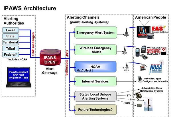
(An explanation of the IPAWS infrastructure is contained in Appendix B)
IPAWS NATIONAL TESTS
FEMA (Federal Emergency Management Agency) issues weekly test messages to the entire
United States through IPAWS. In September 2016 FEMA began issuing national tests along with
an audio message. NPT (National Periodic Test) messages are sent out to all CAP compliant
emergency alerting equipment on a periodic basis.
IPAWS STATE TESTS
The Missouri Department of Public Safety issues a RWT (Required Weekly Test) to the
entire state of Missouri through IPAWS. The Department of Public Safety also generates a
Required Monthly Test (RMT) once per month through IPAWS. The RMT issued by the Missouri
DPS is to be received and retransmitted by all EAS participants across the state of Missouri.
2IPAWS STATE EMERGENCY
Upon declaration by the Governor or an official of the Missouri Department of Public
Safety an emergency message will be sent to all EAS Participants. If a state-wide emergency exists,
alerts will be delivered through IPAWS. If a state-wide alert is issued it follows the same path
utilizing the same equipment the Department of Public Safety tests each month during the RMT.
FEMA and the Missouri Department of Public Safety send all messages, whether test
messages or an actual alert, via IPAWS. Since its inception in 2007, IPAWS has become an
extremely reliable alerting tool for the state of Missouri.
3National Weather Service
The National Weather Service is a vital part of the emergency alert warning system.
Severe weather alerts are issued to specific areas or regions of the state by the utilization of the
SAME (Specific Area Message Encoding) codes. SAME codes allow targeted areas to be alerted
when severe weather approaches. Warnings, watches, and severe weather statements are issued
through IPAWS and 35 NOAA Weather Radio transmitting stations throughout the state.
The FCC does not require stations to air NWS alerts. If live weather coverage is not
possible Missouri broadcasters and cable systems should issue TOR (Tornado Warnings) when the
affected area is within their coverage area. The issuance of SVR (Severe Thunderstorm Warnings)
should be issued if life or property are determined to be threatened. All other weather alerts are to
be administered at the discretion of the individual EAS participant.
March is designated as Severe Weather Preparedness Month. The FCC has given the
National Weather Service in Missouri permission to issue a TOR (Tornado Warning) alert in
March as a means of testing weather alerting equipment. If severe weather is possible during the
time of this scheduled test the National Weather Service will postpone until a later date.
FEMA-IPAWS 2016 Toolkit publication explains HAZCollect as follows: {FEMA and the
National Weather Service (NWS) have partnered to provide the multiple NWS information systems
as an additional channel through which alerting authorities using IPAWS can send public alerts and
warnings. This is made possible through the All-Hazards Emergency Message Collection System,
also known as “HAZCollect”, which automatically relays Non-Weather Emergency Messages from
NWS approved officials to NWS dissemination systems including NOAA’s All Hazards Weather
Radio. Government organizations wishing to utilize HAZCollect must first apply and obtain
permission from the National Weather Service to be a HAZCollect alerting authority.}
(A Complete listing of NOAA weather radio information is listed in Appendix C)
WIRELESS EMERGENCY ALERTS
Wireless Emergency Alerts (WEA) are short emergency messages broadcast to any WEA-
Enabled “smartphone” device. These messages are broadcast by cell towers in the designated areas
to the WEA-Enabled devices. The WEA channel of IPAWS can be used for three categories:
Presidential, AMBER, and Imminent Danger. WEAs are not subscription based, therefore
customers can opt out of all alerts except for Presidential alerts.
All major US Cellular Carriers are participating in WEA, on a voluntary basis. Customers
presently receive AMBER and Weather Alerts as a part of the WEA broadcasts. Information on
WEA alerting is referenced in the FEMA-IPAWS 2016 Toolkit publication.
An estimated 90% of all US citizens carry smartphones with them at all times. Every
smartphone today contains an FM Radio chip placed in it by the manufacturer. Even though there is
no cost to cellular carriers to activate the manufacturer’s FM radio chip, most in the United States
have not been activated by the individual carriers. FM radio chips do not rely on cellular towers to
receive a signal but receive important emergency information from area FM broadcasting stations.
In the interest of public safety, all cellular carriers across the United States should activate the FM
Radio chip in all smartphones.
4SOCIAL MEDIA
The use of social media (Facebook, Instagram, Twitter, etc.) will become an equally
effective part of the Missouri Emergency Alert Plan once standard practices and rules have been
established. A limited amount of information related to Child Abductions and weather related
emergencies is already being disseminated through social media. When regulations and standards
have been clearly established the use of social media will become a very important part of the
Missouri Emergency Alert Plan.
EAS PARTICIPANTS
In this document EAS participants are referred to regularly. This includes all media outlets
listed in Title 47 Part 11.11 of the FCC’s Code of Federal Regulations. This includes all radio,
television, cable operators including video over IP systems, as well as any other agency or outlet
employing the use of Emergency Alerting Encoding/Decoding equipment.
Title 47 Part 11.41 states:
All EAS Participants specified in §11.11 are categorized as Participating National (PN)
sources, and must have immediate access to an EAS Operating Handbook.
5PRIMARY ENTRY POINT
Primary Entry Points (PEP) are designated facilities that receive information directly from the
President of the United States and relays to all EAS participants. KMOX-AM in St. Louis and WHB-AM
in Kansas City are two Primary Entry Points. The Missouri State Emergency Management Agency
(SEMA) office located in Jefferson City can also communicate directly with the President through
NAWAS (National Warning System). SEMA serves as a third Primary Entry Point for the state of
Missouri.
STATE ENTRY POINT
State Entry Points are facilities designated to originate a state-wide alert by the Governor or any
authorized state official. State-wide alerts may be intended for all or any portion of Missouri. Three State
Level Entry Points exist in Missouri.
1) Highway Patrol Troop F in Jefferson City
2) Highway Patrol Troop B in Macon
3) The State Emergency Management Agency in Jefferson City
All three state facilities have equipment capable of generating a state-wide alert. To verify
functionality of the equipment, the state-wide RMT (Required Monthly Test) will be originated from all 3
locations at differing intervals throughout the year.
LOCAL PRIMARY
Local primary (LP) stations serve as state relays across Missouri. The twenty-eight local primary
stations relay all messages received from the Department of Public Safety. Severe weather alerts from the
National Weather Service will be relayed by LP stations or generated locally to EAS participants.
Each LP station receives and re-transmits identical state-wide information. Since the IPAWS
header information is identical, EAS participants can monitor any LP station and receive state-wide
information. The location and power of each LP station makes it possible for at least two LP stations to be
monitored by all EAS participants.
(All Local Primary stations are listed in Appendix D)
6LOCAL OPERATIONAL AREAS
Missouri has 14 Local Operational Areas. Each local operational area has at least 2 local primary
stations. Local primary stations are relay points for EAS participants near them. When a state-wide test
or alert is received, the local primary serves as a relay to forward any relevant message on to the counties
in their respective local area.
Each local operational area will have a local EAS plan constructed by the local EAS committee.
Each local operational area will have a local EAS operational chairman. Local plans list instructions
pertaining to the counties within their own operational area. EAS participants are to adhere to the local
plan as well the state and national plan.
Participants within local operational areas may be instructed to program additional event codes
into their EAS equipment. The local EAS coordinator will determine if additional event codes should be
utilized. The local EAS plan will instruct which event codes and in what counties they should be
programmed to receive. The local plan gives instructions as to what action(s) should be taken once an
authorized event code has been received.
Local Operational Areas will typically have a LP1 (Local Primary 1) and a LP2 (Local Primary 2)
assigned to each area. Additional Local Primary stations may be assigned to an operational area.
(Local operational areas, counties, and local area chairmen are listed in Appendix E)
MONITORING SOURCES
All EAS participants are to monitor at least two LP sources plus IPAWS. NOAA weather radio
channels should be monitored for severe weather information. NOAA weather radio also serves as a
backup for local, state, and national emergencies through HAZCollect which is an All-Hazards
Emergency Message Collection System.
There are at least two local primary stations in each operational area. There is no limit to the number
of LP stations that may be monitored, but should be at least two. If possible, EAS participants should
monitor local primaries from within their operational area. It is permissible to monitor from another
operational area if distance, terrain, or interference make it difficult to monitor from within. Weather
coverage, for instance might be improved by selecting a local primary assignment from another
operational area. EAS Participants are encouraged to make the most logical selection that serves their
community best.
Monitoring assignments may be found in Appendix F. Radio stations are sorted by their frequency.
Television stations are sorted by channel number. Listed with each frequency and channel number are call
signs, the city of license, operational area, and assigned local primary stations. Monitoring assignments
for Cable and Video over IP systems are based on the operational area of the county(s) served in their
viewing area. Counties within each operational area are listed in Appendix F.
7DISSEMINATION OF INFORMATION
Missouri’s state-wide alerting utilizes IPAWS as the means to deliver emergency tests and
messages to all EAS participants.
Missouri’s Department of Public Safety triggers all State-Wide tests and alerts including
Required Monthly Tests (RMT). The Department of Public Safety determines if an occurrence has
reached the level of severity that a state-wide alert should be issued. Alerts originate from one of three
locations that house equipment capable of issuing an IPAWS alert.
a) Missouri State Highway Patrol Troop F (Jefferson City)
b) State Emergency Management Office (Jefferson City)
c) Missouri State Highway Patrol Troop B (Macon)
The Department of Public Safety generates state-wide messages simultaneously to all Missouri
EAS participants over IPAWS. Although capable of being segmented, these messages will typically be
an all-of-Missouri alert.
IPAWS is a very reliable tool. The internet, which is the transport mechanism for IPAWS can
occasionally suffer outages. Missouri implements additional measures to insure each EAS participant
receives important information even if a broadband connection is not available at the time. Extra steps
have been taken to guarantee IPAWS information is delivered to the twenty-eight (LP) relay stations in
the state. LP stations relay state-wide messages to EAS participants around their operational area.
The National Weather Service disseminates information over IPAWS as well as over the NOAA
weather radio network. By utilizing FIPS codes and SAME codes severe weather information can be
targeted for specific regions of the state. LP stations relay severe weather information from the National
Weather Service when it effects their local operational area.
8Event Code Priority, Originators, Locations, and EAS Logging
Instructions on how to program the various brands of Emergency Alert Equipment will vary by
manufacturer. It is beyond the scope of this plan to explain how to program each piece of equipment.
Most manufacturers have websites, tutorials, and offer telephone support in setup and programming. All
equipment makes possible the ability to prioritize the level of a test or an alert.
Priority 1. The FCC requires all Emergency Activation Notifications (EAN) and Emergency
Activation Termination (EAT) be of the highest priority. EAN and EAT require all originators and all
locations be allowed. EAN and EAT alerts are to be logged in the official EAS log which is to be
reviewed and signed by the Chief Operator.
Priority 1. National Periodic Test (NPT) is a national test implemented in 2016. NPT uses the
IPAWS/ CAP system to verify the President can make an immediate announcement to all EAS
participants. NPT tests the same procedures and equipment used by the President to issue an alert to the
nation. NPT requires all originators and all locations be allowed. Each NPT is to be logged on the FCC’s
ETRS (EAS Test Reporting System) Website Portal. Each NPT is to also be logged in the official EAS
log which is to be reviewed and signed by the Chief Operator.
Priority 2. Civil Emergency Messages (CEM) are to be programmed as the second highest
priority in EAS equipment. The CEM alert code will be used by the Governor or a designated state
official in the event of a state-wide emergency. CEM alerts are to be allowed from all originators and
open to all-of-Missouri. CEM alerts are to be logged in the official EAS log which is to be reviewed and
signed by the Chief Operator.
Priority 3. Required Monthly Test (RMT) are to be programmed as the third highest priority.
The State of Missouri uses the RMT to test the state-wide alerting system. RMT tests are to be allowed
from all originators and all areas of the State of Missouri. RMT tests will be re-transmitted by all EAS
participants. This verifies equipment is operating and programmed properly. RMT tests are to be logged
in the official EAS log which is to be reviewed and signed by the Chief Operator.
Priority 3. Tornado Warnings (TOR), Severe Thunderstorm Warnings (SVR), Nuclear Power
Plant Warning (NUW) if applicable, Winter Storm Warning (WSW), or any other life and property
threatening event should be treated with the same priority as RMT tests. Weather related alerts should be
allowed from the National Weather Service, Broadcasters, and Cable systems. These alerts are typically
limited to the local area or specific counties within the local area. Logging is not required for weather
alerts. Logging is however, permitted to verify weather receiving equipment is functioning as it should.
Priority 4. Required Weekly Tests (RWT) and all non-threatening tests will be of the lowest
priority. All tests that fall in this priority level do not require re-transmission. RWT tests are to be
logged in the official EAS log which is to be reviewed and signed by the Chief Operator.
Title 47, Part 73.1870 of the FCC Rules and Regulations defines one of the specific
duties of the Chief Operator is to review and sign an official EAS log. This log must
demonstrate that at least one Required Weekly Test (RWT) or one Required Monthly
Test (RMT) has been received and transmitted once-per-week. The log may be electronic
but must allow for an explanation to be recorded in the event of equipment failure or
reason(s) why a test was not received or transmitted.
910
Event Code Usage
STATEWIDE

The following alerts will be triggered and initiated by The Missouri Department of Public Safety:

    1) Amber Alerts (CAE). Child Abduction Emergency, programmed for all of Missouri and all
       originators.
    2) Civil Emergency Message (CEM). The specific event code used any time there is a statewide
       emergency being issued. The use of the CEM event code signifies the message is coming directly
       from the Governor or a designated state official. By using the CEM event code as a statewide-
       only alert broadcasters and cable operators avoid having to program all possible event codes into
       their EAS units. The CEM code is to be used ONLY if there is a state-wide alert.
    3) Required Monthly Test (RMT)
    4) State Relay Network Test (RMT)
    5) Any special message by the Governor or Department of Public Safety deemed necessary. (CEM)
NATIONAL WEATHER SERVICE

         The FCC does not have specific requirements regarding the re-transmission of severe weather
warnings. If a broadcast or cable facility is unable to air live information during severe weather the EAS
encoder/decoders should be programmed to re-transmit Tornado Warnings (TOR). If determined that
lives or property are threatened Severe Thunderstorm Warnings (SVR) should be re-transmitted. The
National Weather Service will issue severe weather warnings for the following conditions:

    1) Tornado Warnings (TOR). The usage of the TOR event code signifies the National Weather
       Service has confirmed tornadic activity.
    2) Severe Thunderstorm Warning (SVR). The usage of the SVR event code signifies the National
       Weather Service has confirmed high winds, and/or damaging hail, and/or damaging lightning.
    3) Winter Storm Warning (WSW). The usage of the WSW event code signifies the National
       Weather Service has confirmed that snow fall, icing, or extremely low temperatures threaten lives
       or property.
LOCAL ALERTS

        Local officials, broadcasters, and cable operators may originate alerts that effect their Local
Operational Area. Local alerts must be authorized by local authorities. Local area plans instruct
broadcasters and cable operators of event code(s) that can be used. These may include but are not limited
to:
    1) Specific regions and local areas of the state that have been instructed to use the NUW (Nuclear
       Power Plant Warning.
    2) Flash Flood Warning (FFW)
    3) Earthquake Warning (EQW)
    4) Hazardous Material Warning (HMW)
    5) Any other FCC authorized event code that pertains to a local area.
                         (All state and local event codes are listed as Appendix F)

                                                    11
This Page Intentionally Left Blank
12Appendix A
Map of FIPS Codes
NOTE: All of Missouri FIPS Code 29000
13Appendix A (continued)
14Appendix B
IPAWS Infrastructure
15Appendix C
NOAA Weather Radio Information
NOAA Weather Radio Map
16Appendix C (continued)
NOAA Weather Radio by list
Site Name Transmitter Name Call Sign Frequency Power WFO
St. Louis Shrewsbury KDO89 162.550 1000 Weldon Spring, MO
Kansas City (DEGRADED) Independence KID77 162.550 1000 Pleasant Hill, MO
Neosho Newton County KJY82 162.450 1000 Springfield, MO
Jamestown Prairie Home KWN55 162.425 1000 Weldon Spring, MO
Alton Alton KXI35 162.500 300 Springfield, MO
West Plains West Plains KXI38 162.525 300 Springfield, MO
Piedmont Sanders Hollow KXI66 162.425 1000 Paducah, KY
Cape Girardeau Cape Girardeau KXI93 162.550 300 Paducah, KY
El Dorado Springs El Dorado Springs KZZ30 162.475 1000 Springfield, MO
Carrollton Carrollton KZZ34 162.450 1000 Pleasant Hill, MO
Maryville Conception Junction KZZ37 162.425 1000 Pleasant Hill, MO
Trenton Galt KZZ38 162.500 1000 Pleasant Hill, MO
Clinton Shawnee Mound KZZ39 162.500 1000 Pleasant Hill, MO
Branson Indian Ridge KZZ43 162.550 1000 Springfield, MO
Gainesville Marshfield KZZ82 162.425 1000 Springfield, MO
Cameron Cameron KZZ85 162.475 300 Pleasant Hill, MO
Cassville Cassville WNG608 162.500 1000 Springfield, MO
Crocker Fort Leonard Wood WNG648 162.500 1000 Springfield, MO
Bellflower Montgomery County WNG728 162.450 1000 Weldon Spring, MO
17Bourbon Crawford County WWF75 162.525 1000 Weldon Spring, MO
Summersville Summersville WWF76 162.475 1000 Springfield, MO
Wardell Gideon Junction WWG47 162.525 1000 Memphis, TN
Doniphan Doniphan WWG48 162.450 1000 Paducah, KY
Fredericktown Fredericktown WWG49 162.500 1000 Weldon Spring, MO
Avilla Avilla Carthage WXJ61 162.425 1000 Springfield, MO
Hannibal Hannibal WXK82 162.475 1000 Weldon Spring, MO
Columbia Fulton WXL45 162.400 1000 Weldon Spring, MO
Springfield Fordland WXL46 162.400 1000 Springfield, MO
Bloomfield Idalia/Sikeston WXL47 162.400 1000 Paducah, KY
Medill Kahoka WXL99 162.450 300 Davenport, IA
Lancaster Lancaster WXM36 162.550 330 Pleasant Hill, MO
La Plata La Plata WXM39 162.525 330 Pleasant Hill, MO
Hermitage Lake PomDeTerre WXM81 162.450 1000 Springfield, MO
Joplin Joplin WZ2545 162.550 300 Springfield, MO
Eldon (OUT OF SERVICE) Eldon WZ2548 162.550 1000 Springfield, MO
Number of Stations in Missouri = 35
18State-Wide Emergency Script
Suggested Script for a State-Wide emergency message:
“The following is a special message from the Missouri Department of Public Safety.
This is ________________(name), _____________________(position or title), of the
__________________(agency/organization). “
(read the content of the message. Length not to exceed 90 seconds. Message should
include affected areas, if known the length of time the emergency is expected to be in
effect, and if further information will follow or a press conference has been scheduled. If
a press conference is to follow the scheduled time should be given)
End of message script always concludes with:
“This concludes this emergency message from the Missouri Department of Public
Safety and the Emergency Alert System”
State-Wide Monthly Test
The Department of Public Safety generates a Required Monthly Test once-per-month. Tests are
scheduled in advance and will alternate each month between day and evening as required by the FCC.
Daytime tests are scheduled between 10:00 – 10:30 AM. Evening tests are scheduled between 11:30 –
12:00 midnight. The following format is used when conducting a monthly test.
Required Monthly Test Script
“This is a State-Wide Monthly test of the Emergency Alert System. Equipment that could be
used in the event of an emergency is being tested throughout the state of Missouri. If this
had been an actual emergency further information would have followed. This concludes the
State-Wide Monthly Test of the Emergency Alert System.”
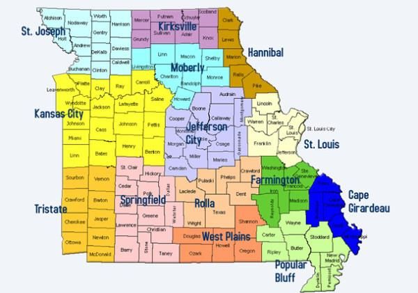
19Map of Missouri’s Operational Areas
20Operational Area Chairmen / Local Primary Stations
Cape Girardeau
LP 1 Station(s) LP 2 Station(s)
Dean Field KEZS FM - 102.9 KZIM AM - 960
Chief Engineer Cape Girardeau Cape Girardeau
(573) 335-8291 Dean Fields Dean Fields
deanfield@riverradio.net (573) 335-8291 (573) 335-8291
Mississippi River Radio deanfields@riverradio.net deanfields@riverradio.net
Cape Girardeau
Farmington
LP 1 Station(s) LP 2 Station(s)
Kevin Brooks KTJJ FM - 98.5 KDBB FM - 104.3
Chief Engineer Farmington Park Hills
(573) 756-6476 Kevin Brooks Jason Loughary
kbrooks@j98.com (573) 756-6476 (573) 431-2000
Alpha Media kbrooks@j98.com jason@b104fm.com
Farmington
Hannibal
LP 1 Station(s) LP 2 Station(s)
Gary Glaenzer KGRC FM KHMO AM - 1270
Chief Operator Quincy, IL Hannibal
(217) 370-7257 Phil Reilly Gary Glaenzer
Glaenzer@frontier.com (217) 242-8310 (217) 370-7257
Townsquare Media preilly@staradio.com Glaenzer@frontier.com
Hannibal
21Kansas City
LP 1 Station(s) LP 2 Station(s)
Kirk Chestnut KCSP AM - 610 KCMO FM - 94.9
Chief Engineer Mission, KS Mission, KS
(913) 744-3903 Kirk Chestnut Dennis Eversoll
kchestnut@entercom.com (913) 744-3903 (913) 514-3000
Entercom Radio of Kansas City kchestnut@entercom.com dennis.eversoll@cumulus.com
Mission, KS
KTXY FM - 106.9
Columbia, MO
Mike Mayfield
(573) 875-1099
Poplar Bluff
LP 1 Station(s) LP 2 Station(s)
Charley Lampe KKLR FM - 94.5 KJEZ FM - 95.5
Chief Engineer Poplar Bluff Poplar Bluff
(573) 718-2293 Charley Lampe Charley Lampe
charley@riverradio.net (573) 718-2293 (573) 718-2293
Mississippi River Radio charley@riverradio.net charley@riverradio.net
Poplar Bluff, MO
Rolla
LP 1 Station(s) LP 2 Station(s)
Mike Edwards KJEL FM - 103.7 KZNN FM - 105.3
General Manager Lebanon Rolla
(417) 532-9111 Mike Edwards Steve Gigstad
mike.edwards@ (417) 532-9111 (573) 364-2525
alphamediausa.com mike.edwards@ kznnpd@yahoo.com
Alpha Media, Lebanon alphamediausa.com
22St. Louis
LP 1 Station(s) LP 2 Station(s)
Mike Waldman KMOX AM - 1120 WIL FM - 92.3
Station Engineer St. Louis St. Louis
(314) 444-3274 Joe Geerling Marshall Rice
mwaldman@stl.cbs.com (314) 444-3273 (314) 983-6000
CBS, St. Louis jpgeerling@stl.cbs.com marice@hubbardradio.com
Springfield
LP 1 Station(s) LP 2 Station(s)
David Rahmoeller KTTS FM - 94.7 KTXR FM - 101.3
Chief Engineer Springfield Springfield
(417) 865-6614 David Rahmoeller Dale Blankenship
david.rahmoeller@scripps.com (417) 865-6614 (417) 862-3990
The E.W. Scripps Company david.rahmoeller@scripps.com ktxr@radiospringfield.com
Springfield
Central Missouri (Columbia/Jeff City)
LP 1 Station(s) LP 2 Station(s)
Steve Morse KTXY FM (Columbia) - 106.9 KWOS AM - 950
Chief Engineer Columbia Jefferson City
(573) 893-5696 Mike Mayfield Steve Morse
stevem@zrgmail.com (573) 875-1099 (573) 893-5696
Zimmer Radio of Mid Missouri mikem@zrgmail.com stevem@zrgmail.com
Jefferson City
KATI FM - 94.3
Jefferson City
Steve Morse
23(573) 893-5696
stevem@zrgmail.com
Kirksville
LP 1 Station(s) LP 2 Station(s)
John Wise KRXL FM - 94.5 KTUF FM - 93.7
Operations Manager Kirksville Kirksville
(660) 665-9841 John Wise John Wise
johnwise@cableone.net (660) 665-9841 (660) 665-9841
KIRX, Inc. johnwise@cableone.net johnwise@cableone.net
Kirksville
Moberly
LP 1 Station(s) LP 2 Station(s)
Lloyd Collins KRES FM - 104.7 KZBK FM - 96.9
Chief Engineer Moberly Brookfield
(660) 263-1500 Lloyd Collins Dale Palmer/Jeff elliot
Lloyd.collins@ (660) 263-1500 (660) 258-3383
alphamediausa.com Lloyd.collins@ gm@bestbroadcastgroup.com
Alpha Media, Moberly alphamediausa.com kfmz@bestbroadcastgroup.com
St. Joseph
LP 1 Station(s) LP 2 Station(s)
Kevin Wagner KFEQ AM / KSJQ FM KKJO FM - 105.5
Director of Operations 680 / 92.7 St. Joseph
(816) 752-0095 St. Joseph Kevin Wagner
kevin.wagner@eagleradio.net Kevin Wagner (816) 752-0095
Eagle Communications (816) 752-0095 kevin.wagner@eagleradio.net
St. Joseph kevin.wagner@eagleradio.net
24Tri-State (Joplin/Pittsburg)
LP 1 Station(s) LP 2 Station(s)
Ron Peterson, Sr. KMXL FM - 95.1 KBTN FM - 99.7
General Manager Carthage Joplin
(417) 359-3417 Ron Peterson, Sr. Allen Riley
ronsr@cbciradio.com (417) 359-3417 (417) 499-7596
Carthage Broadcasting Company ronsr@cbciradio.com ariley@ami-joplin.com
Carthage, MO
West Plains
LP 1 Station(s) LP 2 Station(s)
Dwane Porter KSPQ FM - 93.9 KAMS FM - 95.1
Chief Engineer West Plains Thayer
(417) 264-7211 Jim White Dwane Porter
dwane100@hotmail.com (417) 293-1935 cell (417) 264-7211
E-Communications (417) 932-5179 home dwane100@hotmail.com
Thayer, MO olewizard52@hotmail.com
25Monitoring Assignments by Operational Area
Cape Girardeau
Call City of Monitoring Assignments Area
Sign License LP1 LP2 LP3 NOAA WX Coordinator
KZIM AM Cape Girardeau Dean Field
KGIR AM Cape Girardeau (573) 335-8291
KAPE AM Cape Girardeau deanfield@riverradio.net
KCHR AM Charleston
KYMO AM East Prairie
KJXX AM Jackson
KSIM AM Sikeston
KRHW AM Sikeston
Farmington
Call City of Monitoring Assignments Area
Sign License LP1 LP2 LP3 NOAA WX Coordinator
KREI AM Farmington
KFMO AM Flat River Kevin Brooks
KYLS AM Fredericktown (573) 756-6476
KYRO AM Troy kbrooks@j98.com
KTNX FM Arcadia
KHCR FM Bismarck
KDBB FM Bonne Terre
KDKN FM Ellington
KTJJ FM Farmington
KYLS FM Ironton
KLMZ FM Leadwood
KBGM FM Park Hills
KNLP FM Potosi
KHZR FM Potosi
KSEF FM St. Genevieve
26KBIY FM Van Buren
Hannibal
Call City of Monitoring Assignments Area
Sign License LP1 LP2 LP3 NOAA WX Coordinator
KHMO AM Hannibal
KPVR FM Bowling Green Gary Glaenzer
KCSW FM Canton (217) 370-7257
KRRY FM Canton glaenzer@frontier.com
KJIR FM Hannibal
KGRC FM Hannibal
KHBL FM Hannibal
KJFM FM Louisanna
KZZK FM New London
KKAC FM Vandalia
KHQA TV Hannibal
27Jefferson City
Call City of Monitoring Assignments Area
Sign License LP1 LP2 LP3 NOAA WX Coordinator
KWRT AM Boonville
KRLL AM California Steve Morse
KFRU AM Columbia (573) 893-5696
KTGR AM Columbia stevem@zrgmail.com
KFAL AM Fulton
KWOS AM Jefferson City
KLIK AM Jefferson City
KXEO AM Mexico
KRMS AM Osage Beach
KYLF FM Adrian
KOQL FM Ashland
KWJK FM Boonville
KCLR FM Boonville
KATI FM California
KCVO FM Camdenton
KMFC FM Centralia
KSDC FM Centralia
KCOU FM Columbia
KOPN FM Columbia
KMUC FM Columbia
KBIA FM Columbia
KCMQ FM Columbia
KPLA FM Columbia
KBXR FM Columbia
KLJE FM Columbia
KLOZ FM Eldon
KZWV FM Eldon
KSSZ FM Fayette
KWWU FM Fulton
KTGR FM Fulton
KRFL FM Fulton
KMCV FM High Point
KJLU FM Jefferson City
KOTC FM Jefferson City
KBBM FM Jefferson City
28KZJF FM Jefferson City
KTXY FM Jefferson City
KQUL FM Lake Ozark
KCKP FM Laurie
KJMO FM Linn
KBMC FM Macks Creek
KJAB FM Mexico
KAUD FM Mexico
KWWR FM Mexico
KTRI FM Mexico
KMCR FM Montgomery City
KNLG FM New Bloomfield
KIRL FM Osage Beach
KMYK FM Osage Beach
KCVK FM Otterville
KOTT FM Otterville
KHJR FM St. Thomas
KCRL FM Sunrise Beach
KTKS FM Versailles
KOMU TV Columbia
KMIZ TV Columbia
KRCG TV Jefferson City
KNLJ TV Jefferson City
KRBK TV Osage Beach
29Kansas City
Call City of Monitoring Assignments Area
Sign License LP1 LP2 LP3 NOAA WX Coordinator
KCWJ AM Blue Springs
KMAM AM Butler Kirk Chestnut
KAOL AM Carrollton (913) 744-3903
KCTO AM Cleveland kchestnut@
KDKD AM Clinton entercom.com
KEXS AM Excelsior Springs
KMVG AM Gladstone
KCTE AM Independence
KCSP AM Kansas City
KCMO AM Kansas City
WHB AM Kansas City
KMBZ AM Kansas City
KDMR AM Kansas City
KPRT AM Kansas City
KLEX AM Lexington
KCXL AM Liberty
KMMO AM Marshall
KSIS AM Sedalia
KDRO AM Sedalia
KOKO AM Warrensburg
KMOE FM Butler
KMZU FM Carrollton
KDKD FM Clinton
KLRQ FM Clinton
KPGZ FM Excelsior Springs
KCJK FM Garden City
KCFX FM Harrisonville
KJNW FM Kansas City
KCUR FM Kansas City
KKFI FM Kansas City
KMXV FM Kansas City
KCMO FM Kansas City
KCPZ FM Kansas City
KRBZ FM Kansas City
KUAW FM Kansas City
30KZPT FM Kansas City
KONN FM Kansas City
KPPZ FM Kansas City
KCKC FM Kansas City
KPRS FM Kansas City
KBEQ FM Kansas City
KOJH FM Kansas City
KCVQ FM Knob Noster
KXKX FM Knob Noster
KPOW FM La Monte
KLRX FM Lee's Summit
KWJC FM Liberty
WDAF FM Liberty
KRLI FM Malta Bend
KMVC FM Marshall
KMMO FM Marshall
KMJK FM North Kansas City
KGSP FM Parkville
KEXS FM Ravenwood
KAYX FM Richmond
KSDL FM Sedalia
KTBG FM Warrensburg
KAYQ FM Warsaw
KWKJ FM Windsor
KCPT TV Kansas City
KCTV TV Kansas City
KMBC TV Kansas City
KPXE TV Kansas City
KCWE TV Kansas City
WDAF TV Kansas City
KSHB TV Kansas City
KSMO TV Kansas City
KMOS TV Sedalia
31Kirksville
Call City of Monitoring Assignments Area
Sign License LP1 LP2 LP3 NOAA WX Coordinator
KIRX AM Kirksville
KTTN AM Trenton John Wise
KTRM FM Kirksville (660) 665-9841
KKTR FM Kirksville johnwise@
KVSR FM Kirksville cableone.net
KEFL FM Kirksville
KCKV FM Kirksville
KTUF FM Kirksville
KRXL FM Kirksville
KRFR FM Kirksville
KLTE FM Kirksville
KMEM FM Memphis
KTTN FM Trenton
KTVO TV Kirksville
32Moberly
Call City of Monitoring Assignments Area
Sign License LP1 LP2 LP3 NOAA WX Coordinator
KFMZ AM Brookfield
KCHI AM Chillicothe Lloyd Collins
KLTI AM Macon (660) 263-1500
KWIX AM Moberly Lloyd.collins@
KZBK FM Brookfield alphamediausa.com
KWIX FM Cairo
KLWL FM Chillicothe
KRNW FM Chillicothe
KCKE FM Chillicothe
KCHI FM Chillicothe
KPIP FM Fayette
KCKZ FM Huntsville
KIRK FM Macon
KCNF FM Macon
KTCM FM Madison
KDWD FM Marceline
KSDQ FM Moberly
KBKC FM Moberly
KRES FM Moberly
KZZT FM Moberly
KWBZ FM Monroe City
KICK FM Palmyra
KULH FM Wheeling
33Poplar Bluff
Call City of Monitoring Assignments Area
Sign License LP1 LP2 LP3 NOAA WX Coordinator
KCRV AM Caruthersville
KDEX AM Dexter Charley Lampe
KDFN AM Doniphan (573) 718-2293
KBOA AM Kennett charley@
KMAL AM Malden riverradio.net
KPWB AM Piedmont
KWOC AM Poplar Bluff
KLID AM Poplar Bluff
KMIS AM Portageville
KAIA FM Bloomfield
KFEB FM Campbell
KCRV FM Caruthersville
KHJM FM Dexter
KDEX FM Dexter
KYEC FM Doniphan
KOEA FM Doniphan
KQJN FM Doniphan
KMIS FM Gideon
KCBW FM Grandin
WGCQ FM Hayti
KAUF FM Kennett
KXOQ FM Kennett
KLSC FM Malden
KZMA FM Naylor
KTMO FM New Madrid
KPWB FM Piedmont
KOKS FM Poplar Bluff
KLUH FM Poplar Bluff
KPBR FM Poplar Bluff
KPPL FM Poplar Bluff
KKLR FM Poplar Bluff
KJEZ FM Poplar Bluff
KAHR FM Poplar Bluff
KPBM FM Poplar Bluff
KLUE FM Poplar Bluff
KYHO FM Poplar Bluff
KPOB TV Poplar Bluff
34Rolla
Call City of Monitoring Assignments Area
Sign License LP1 LP2 LP3 NOAA WX Coordinator
KBTC AM Houston
KBNN AM Lebanon Mike Edwards
KLWT AM Lebanon 162.40 (417) 532-9111
KELE AM Mt. Grove 162.55 mike.edwards@
KTTR AM Rolla alphamediausa.com
KMOZ AM Rolla
KSMO AM Salem
KTUI AM Sullivan
KIIK AM Waynesville
KJPW AM Waynesville
KQBD FM Bunker
KZGM FM Cabool
KCVY FM Cabool
KOZX FM Cabool
KGNN FM Cuba
KCKF FM Cuba
KQXQ FM Cuba
KFCV FM Dixon
KCVZ FM Dixon
KUMR FM Doolittle
KUNQ FM Houston
KTTK FM Lebanon
KJEL FM Lebanon
KCLQ FM Lebanon
KELE FM Mountain Grove
KXMO FM Owensville
KMST FM Rolla
KMNR FM Rolla
KJTR FM Rolla
KDAA FM Rolla
KZNN FM Rolla
KCVX FM Salem
KKID FM Salem
KSOZ FM Salem
35KTTR FM St. James
KFLW FM St. Robert
KLPW FM Steeleville
KSLN FM Sullivan
KTUI FM Sullivan
KNLN FM Vienna
KFBD FM Waynesville
KOZQ FM Waynesville
36Springfield
Call City of Monitoring Assignments Area
Sign License LP1 LP2 LP3 NOAA WX Coordinator
KSWM AM Aurora
KYOO AM Bolivar David Rahmoeller
KOMC AM Branson (417) 865-6614
KRMO AM Cassville david.rahmoeller@
KBCV AM Hollister scripps.com
KMRF AM Marshfield
KWTO AM Springfield
KBFL AM Springfield
KSGF AM Springfield
KICK AM Springfield
KGMY AM Springfield
KLFJ AM Springfield
KSGF FM Ash Grove
KSWF FM Aurora
KLFC FM Branson
KOZO FM Branson
KTCQ FM Branson
KRZK FM Branson
KQRA FM Brookline
KBFL FM Buffalo
KESM FM El Dorado Springs
KYOO FM Half Way
KCXM FM Kimberling City
KOMC FM Kimberling City
KEGQ FM Kimberling City
KXEA FM Lowry City
KQOH FM Marshfield
KKLH FM Marshfield
KKBL FM Monet
KRVI FM Mount Vernon
KGBX FM Nixa
KCVJ FM Osceola
KOSP FM Ozark
KTOZ FM Pleasant Hope
KSMS FM Point Lookout
37KCOZ FM Point Lookout
KNHN FM Republic
KADI FM Republic
KVTS FM Republic
KCKJ FM Sarcoxie
KQMO FM Shell Knob
KSPW FM Sparta
KWND FM Springfield
KWFC FM Springfield
KSCV FM Springfield
KSMU FM Springfield
KTTS FM Springfield
KXUS FM Springfield
KDRU FM Springfield
KWTO FM Springfield
KTXR FM Springfield
KWPQ FM Springfield
KRWP FM Stockton
KIXK FM Wheatland
KOMG FM Willard
KOLR TV Springfield
KSPR TV Springfield
KOZK TV Springfield
KOZL TV Springfield
KYTV TV Springfield
38St. Joseph
Call City of Monitoring Assignments Area
Sign License LP1 LP2 LP3 NOAA WX Coordinator
KQTV TV St. Joseph
KAAN AM Bethany Kevin Wagner
KMRN AM Cameron (816) 752-0095
KNIM AM Maryville kevin.wagner@
KFEQ AM St. Joseph eagleradio.net
KGNM AM St. Joseph
KESJ AM St. Joseph
KMWC FM Bethany
KAAN FM Bethany
WRVX FM Cameron
KKWK FM Cameron
KJCV FM Country Club
KGOZ FM Gallatin
KXCV FM Maryville
KZLX FM Maryville
KVVL FM Maryville
KSJQ FM Savannah
KSJI FM St. Joseph
KSRD FM St. Joseph
KFOH FM St. Joseph
KLHM FM St. Joseph
KKJO FM St. Joseph
KRSS FM Tarkio
KTAJ TV St. Joseph
39St. Louis
Call City of Monitoring Assignments Area
Sign License LP1 LP2 LP3 NOAA WX Coordinator
KFUO AM Clayton
KSIV AM Clayton Mike Waldman
KQQZ AM Desoto (314) 444-3274
KJFF AM Festus mwaldman@
KHOJ AM St. Charles stl.cbs.com
KTRS AM St. Louis
KYFI AM St. Louis
KSTL AM St. Louis
WEW AM St. Louis
KXEN AM St. Louis
KMOX AM St. Louis
KXFN AM St. Louis
KZQZ AM St. Louis
KATZ AM St. Louis
KLPW AM Union
KWRE AM Warrenton
KRAP AM Washington
KGNA FM Arnold
KGNX FM Ballwin
KMJM FM Bridgeton
KNLH FM Cedar Hill
KWUR FM Clayton
KLJY FM Clayton
KSHE FM Crestwood
KDJR FM De Soto
KXQX FM Elsberry
KFTN FM Fenton
KCFV FM Ferguson
KTBJ FM Festus
KWAP FM Florissant
KFTK FM Florissant
WHHL FM Hazelwood
KQQX FM Hermann
KOIU FM High Ridge
KRHS FM Overland
40KCLC FM St. Charles
KWEC FM St. Charles
KDXH FM St. Louis
KDHX FM St. Louis
KWMU FM St. Louis
KSIV FM St. Louis
WIL FM St. Louis
KSD FM St. Louis
KNOU FM St. Louis
KYKY FM St. Louis
KTGP FM St. Louis
KEZK FM St. Louis
KYGV FM St. Louis
KLOU FM St. Louis
KSLZ FM St. Louis
KFNS FM Troy
KFAV FM Warrenton
KGNV FM Washington
KSLQ FM Washington
KWRH FM Webster Grove
KNLC TV St. Louis
KMOV TV St. Louis
KPLR TV St. Louis
KDNL TV St. Louis
KSDK TV St. Louis
KETC TV St. Louis
KTVI TV St. Louis
Tri-State
Call City of Monitoring Assignments Area
Sign License LP1 LP2 LP3 NOAA WX Coordinator
KDMO AM Carthage
KZYM AM Joplin Ron Peterson
KZRG AM Joplin (417) 359-3417
WMBH AM Joplin ronsr@cbciradio.com
KBTN AM Neosho
KNEM AM Nevada
KKLL AM Webb City
41KWXD FM Asbury
KCAH FM Carthage
KMXL FM Carthage
KSHQ FM Deerfield
KXMS FM Joplin
KOBC FM Joplin
KSYN FM Joplin
KIXQ FM Joplin
KHST FM Lamar
KNEO FM Neosho
KBTN FM Neosho
KNMO FM Nevada
KIGL FM Seligman
KJMK FM Webb City
KXDG FM Webb City
KWEB FM Webb City
KOZJ TV Joplin
KODE TV Joplin
KSNF TV Joplin
West Plains
Call City of Monitoring Assignments Area
Sign License LP1 LP2 LP3 NOAA WX Coordinator
KKOZ AM Ava
KALM AM Thayer Dwane Porter
KWPM AM West Plains (417) 264-7211
KUKU AM Willow Springs dwane100@
KKOZ FM Ava hotmail.com
KBMV FM Birch Tree
KQDW FM Eminence
KBOD FM Gainsville
KUPH FM Mountain View
KSAR FM Thayer
KSMW FM West Plains
KSPQ FM West Plains
KKDY FM West Plains
KUKU FM Willow Springs
42Addendum A
NOAA Weather Radio City & Frequency Listing
Site Name Transmitter Name Call Sign Frequency Power WFO
St. Louis Shrewsbury KDO89 162.550 1000 Weldon Spring, MO
Kansas City Independence KID77 162.550 1000 Pleasant Hill, MO
Neosho Newton County KJY82 162.450 1000 Springfield, MO
Jamestown Prairie Home KWN55 162.425 1000 Weldon Spring, MO
Alton Alton KXI35 162.500 300 Springfield, MO
West Plains West Plains KXI38 162.525 300 Springfield, MO
Piedmont Sanders Hollow KXI66 162.425 1000 Paducah, KY
Cape Girardeau Cape Girardeau KXI93 162.550 300 Paducah, KY
El Dorado Springs El Dorado Springs KZZ30 162.475 1000 Springfield, MO
Carrollton Carrollton KZZ34 162.450 1000 Pleasant Hill, MO
Maryville Maryville KZZ37 162.425 1000 Pleasant Hill, MO
Trenton Galt KZZ38 162.500 1000 Pleasant Hill, MO
Clinton Shawnee Mound KZZ39 162.500 1000 Pleasant Hill, MO
Branson Indian Ridge KZZ43 162.550 1000 Springfield, MO
Gainesville Gainesville KZZ82 162.425 1000 Springfield, MO
Cameron Cameron KZZ85 162.475 300 Pleasant Hill, MO
Cassville Cassville WNG608 162.500 1000 Springfield, MO
Crocker Fort Leonard Wood WNG648 162.500 1000 Springfield, MO
43Bellflower Montgomery County WNG728 162.450 1000 Weldon Spring, MO
Bourbon Crawford County WWF75 162.525 1000 Weldon Spring, MO
Summersville Summersville WWF76 162.475 1000 Springfield, MO
Wardell Gideon Junction WWG47 162.525 1000 Memphis, TN
Doniphan Doniphan WWG48 162.450 1000 Paducah, KY
Fredericktown Fredericktown WWG49 162.500 1000 Weldon Spring, MO
Avilla Avilla Carthage WXJ61 162.425 1000 Springfield, MO
Camdenton Osage Beach WXJ90 162.550 1000 Springfield, MO
Hannibal Hannibal WXK82 162.475 1000 Weldon Spring, MO
Columbia Fulton WXL45 162.400 1000 Weldon Spring, MO
Springfield Fordland WXL46 162.400 1000 Springfield, MO
Bloomfield Idalia/Sikeston WXL47 162.400 1000 Paducah, KY
Medill Kahoka WXL99 162.450 300 Davenport, IA
Lancaster Lancaster WXM36 162.550 330 Pleasant Hill, MO
La Plata La Plata WXM39 162.525 330 Pleasant Hill, MO
Hermitage Lake PomDeTerre WXM81 162.450 1000 Springfield, MO
Joplin Joplin WZ2545 162.550 300 Springfield, MO
44Addendum B
EAS Event Codes
ADR - Administrative Message
AVA - Avalanche Watch
AVW - Avalanche Warning
BZW - Blizzard Warning
CAE - Child Abduction Emergency
CDW - Civil Danger Warning
CEM - Civil Emergency Message
CFA - Coastal Flood Watch
CFW - Coastal Flood Warning
DMO - Practice/Demo Warning
DSW - Dust Storm Warning
EAN - Emergency Action Notification
EAT - Emergency Action Termination
EQW - Earthquake Warning
EVI - Evacuation Immediate
FFA - Flash Flood Watch
FFS - Flash Flood Statement
FFW - Flash Flood Warning
FLA - Flood Watch
FLS - Flood Statement
FLW - Flood Warning
FRW - Fire Warning
HLS - Hurricane Statement
HMW - Hazardous Materials Warning
HUA - Hurricane Watch
HUW - Hurricane Warning
HWA - High Wind Watch
HWW - High Wind Warning
LAE - Local Area Emergency
LEW - Law Enforcement Warning
NIC - National Information Center
NMN - Network Message Notification
45NPT - National Periodic Test
NUW - Nuclear Power Plant Warning
RHW - Radiological Hazard Warning
RMT - Required Monthly Test
RWT - Required Weekly Test
SMW - Special Marine Warning
SPS - Special Weather Statement
SPW - Shelter in Place Warning
SVA - Severe Thunderstorm Watch
SVR - Severe Thunderstorm Warning
SVS - Severe Weather Statement
TOA - Tornado Watch
TOE - 911 Telephone Outage Emergency
TOR - Tornado Warning
TRA - Tropical Storm Watch
TRW - Tropical Storm Warning
TSA - Tsunami Watch
TSW - Tsunami Warning
VOW - Volcano Warning
WSA - Winter Storm Watch
WSW - Winter Storm Warning
4647
You can also read