Moreton Island conditions report - nprsr.qld.gov.au
←
→
Page content transcription
If your browser does not render page correctly, please read the page content below
Moreton Island conditions report
Moreton Island conditions report
Your safety is our concern, but your responsibility.
Last updated 20th September 2018 Visit online: www.des.qld.gov.au
Camping & facilities Tides Brisbane Bar
Campfire information – Campfires are permitted at totem campsites in the five camping zones and in
Blue Lagoon, Comboyuro Point and Ben‐Ewa camping areas. Fires are not permitted on the beach and
camping areas at North Point and The Wrecks. High fire danger period, keep campfires small, never
leave fires unattended and always extinguish with water – fines apply. Be prepared and pack a fuel
stove in case weather conditions deteriorate and a Total Fire Ban is activated. Smoking is prohibited
within 10m from most visitor facilities in national parks. Portable toilet waste disposal facilities are
available at Comboyuro Point and Ben‐Ewa camping areas. A QldParks‐Wifi hotspot is available at
The Wrecks.
Beach driving conditions
Driving on dunes, vegetated areas and on unofficial tracks can cause significant damage to the dunal
systems, and contribute significantly to the risk of further erosion. To avoid a fine drive only on
officially constructed roads, tracks and beaches.
Tangalooma to Kooringal (western beach) is accessible at low tide only.
Tangalooma to Bulwer (western beach) ‐ access mid to low tide; use caution when crossing creeks.
Bulwer to North Point (via northern beach) is constantly changing and rarely trafficable due to the
natural outflow of the Heath Island tidal creek system. Sand erosion is apparent between Comboyuro
Point and Heath Island and caution should be exercised in this area. Shallow creeks and draining
gutters are boggy in this area and extreme caution should be exercised at all water crossings.
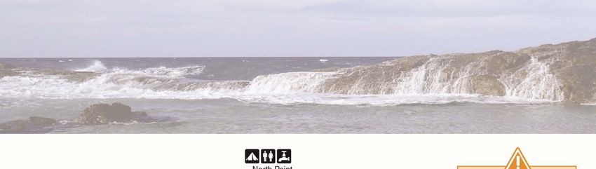
Cape Moreton to Mirapool Bypass (eastern beach) – Deep holes can occur along the entire length of
Eastern Beach making travel difficult between mid and high tides. Tides can cause unexpected and
hidden banks, washouts and gutters. Care should be exercised during high tides around the timbered
area north of the Kooringal‐Mirapool Road and between Cape Moreton and Bulwer Blue Lagoon Road.
North Point – Vehicle access to North Point from Five Hills Road along the beach can be problematic
due to tidal influences. Visit three hours either side of low tide to avoid getting stranded at North
Point and Champagne Rocks. Drivers are advised not to traverse the area on an approaching high tide.
Cape Moreton–North Point Road – is firm and trafficable.
Yellow Patch – beach lagoons and waterways are constantly changing. Caution: deep water at some
creek and lagoon crossings with quicksand on lagoon edges and shoreline erosion.
Inland track conditions
Low rainfall and warm weather over the last 6 weeks has dry out the sand making roads and tracks © Commonwealth Australia
soft and boggy. Increased traffic over the holiday period without significant rain is likely to make
conditions deteriorate rapidly. Check your tyre pressure. Too much tyre pressure can make driving Tide variations
Tides on Moreton Island vary
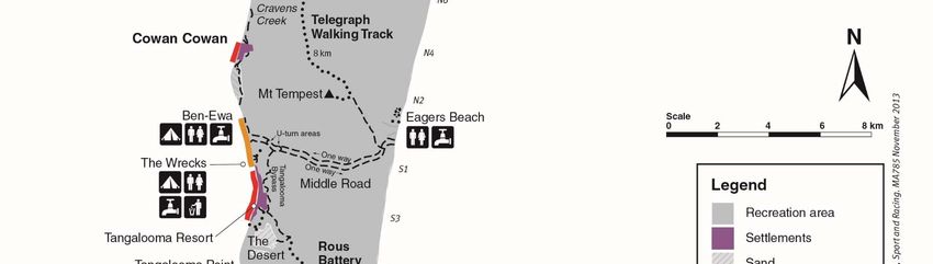
difficult and damage roads and vehicles. Cowan Bypass – is firm and easy to traverse. in a number of places:
Bulwer‐North Point Road (via Five Hills) is firm with some rough sections. Suitable for high Ocean Beach is 1hr 30mins
earlier than Brisbane Bar
clearance 4WD vehicles only. Bulwer‐Blue Lagoon Road is soft in some sections but trafficable.
Day’s Gutter is 45mins
Blue Lagoon day‐use access track and carpark is soft but trafficable. Alternative access to Blue earlier than Brisbane Bar.
Lagoon is available via the walking track from Blue Lagoon camping area. Mirapool Bypass Road is Tangalooma is 40mins
earlier than Brisbane Bar.
firm but rough in some spots. Tangalooma Bypass Road is soft and rough with some very boggy
sections. Middle Road is mostly firm but rough with boggy sections around the Tangalooma Bypass
intersection and ring‐road.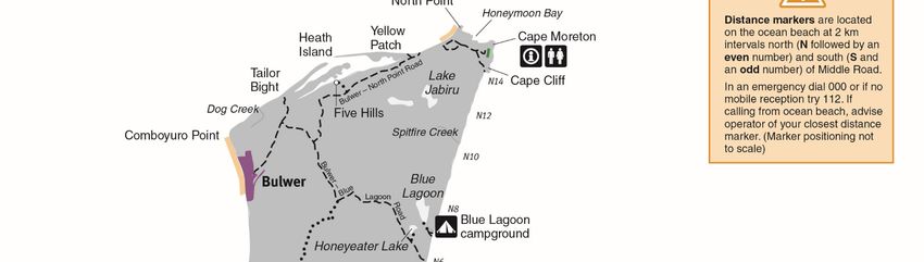
Walking track conditions Tides Brisbane Bar
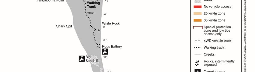
Walking tracks ‐ Rous Battery, Telegraph, Five Hills and Tempest walking tracks are open and in
good condition. Take your own water and stay hydrated in hot conditions. Note: there are no water
points along these walks. Walking tracks may be closed at short notice during periods of very high
fire danger. Please check for Park Alerts before setting out and obey any track closed signs.
General alerts
Driving on Moreton Island
Queensland road rules apply and are enforced on all island tracks and beaches.
Low clearance and all‐wheel drive vehicles are not suitable for Moreton Island’s inland tracks.
For beach driving, travel at low tide or within two hours either side of low tide.
Ensure your vehicle is in 4WD and free‐wheeling hubs (if fitted) are locked.
Vehicle recovery equipment is essential. Know how to use it correctly before you get stuck.
Reducing your tyre pressure will assist when driving on soft sand. Remember to keep within the
tyre manufacturer's specifications as reduced tyre pressure will affect your vehicle's
performance.
When driving with reduced tyre pressure, avoid sharp turns, sudden braking, high‐speeds and
driving over rough surfaces. Tyres can come off their rims and cause serious accidents.
Always carry a tyre gauge, air pump, spare tyre, first‐aid kit and adequate water, food and fuel.
Ensure that you have a valid vehicle access permit.
Tangalooma Wrecks
Visitors should obey all warning signs and avoid getting too close, climbing on or swimming through
the shipwreck structures.
Weather Conditions
Check Bureau of Meteorology web site or tune your car radio to Regional ABC stations for updated
weather forecasts and alerts.
Vehicle Recovery Service
A private vehicle recovery service operates on Moreton Island. For assistance and pricing contact
Moreton Island Recovery Service on 07 3408 3545 (0414 949876) or 07 3408 3930 (0475 563642).
Marine Animal Strandings
© Commonwealth Australia
Contact RSPCA Qld on 1300 ANIMAL (1300 264 625) to report any injured or dead dugong, turtles,
whales or dolphins.
Tide variations
Tides on Moreton Island vary
Additional Information in a number of places:
Check Park Alerts for updates and information regarding any changes to park conditions. Ocean Beach is 1hr 30mins
earlier than Brisbane Bar
Day’s Gutter is 45mins
earlier than Brisbane Bar.
Tangalooma is 40mins
earlier than Brisbane Bar.
While this information was prepared with care, it is based on the best available information at the time and is indicative only. Visitors are reminded that
conditions change constantly due to climatic fluctuations and other factors. No liability is accepted by the Queensland Government for any decisions or
actions taken on the basis of this information.
You can also read