Mt Messenger Bypass Archaeological Review Historic Heritage Assessment - Prepared by: New Plymouth District Council
←
→
Page content transcription
If your browser does not render page correctly, please read the page content below
Archaeological Review

                Mt Messenger Bypass
                     Historic Heritage Assessment
                                6 October 2017

Prepared for:                                    Prepared by:

New Plymouth District Council                    Geometria Limited

Private Bag 2025                                 114A Govett Avenue

New Plymouth 4342                                Frankleigh Park

New Zealand                                      New Plymouth 4310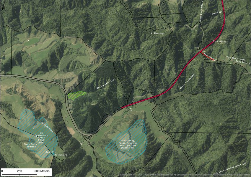
Archaeological Review: Mt Messenger Bypass Historic Heritage Assessment

Quality Information

Document:      Archaeological Review: Mt Messenger Bypass Historic Heritage
               Assessment

Ref:           2017-209

Date:          6 October 2017

Prepared by: Daniel McCurdy

Revision History

 Revision          Revision Date        Details                         Authorized Name

 Draft             02/10/2017                                           McCurdy

 Review            06/10/2017           Internal Review                 Gibb

 Final Draft       06/10/2017                                           McCurdy

 Final             14/05/2018           Draft removed                   McCurdy

© GEOMETRIA 2017                                                                          Page 1
Archaeological Review: Mt Messenger Bypass Historic Heritage Assessment

Table of Contents

Executive Summary                                                                           4
1.0 Introduction                                                                            5
2.0 Methodology                                                                             5
  2.1 Limitations                                                                           5
3.0 Project Description                                                                     6
4.0 Review                                                                                  7
  4.1 Methodology                                                                           7
  4.2 Historical Background – Maori                                                         7
  4.3 Historical Background – European                                                      9
  4.4 Historical Survey                                                                     11
  4.5 Field Investigation                                                                   17
  4.6 Discussion and Conclusions                                                            21
  4.7 Effects of the proposal                                                               23
5.0 Conclusion                                                                              23
Bibliography                                                                                24
Appendix 1: List of historic survey plans consulted                                         25
Appendix 2: Discussion on Northern Taranaki sites within rugged landscapes                  26
Appendix 3: Discussion on the archaeology of Te Wera                                        28

© GEOMETRIA 2017                                                                            Page 2
Archaeological Review: Mt Messenger Bypass Historic Heritage Assessment

Figures

Figure 1: Proposed bypass route (red) and southern fill are (green). Existing road
        alignment in orange..............................................................................................6
Figure 2: 1863 Confiscation Line (blue), 500m north of project area (red) ..............8
Figure 3: Road cutting at the base of Mt Messenger, 1901 (Auckland Weekly News
        Supplement, 1901, p. 4) ........................................................................................9
Figure 4: Examples of papa kilns in Whangamomona (sources: top (Morris, 1998),
        bottom (Garcia, 1940)).........................................................................................10
Figure 5: Plan showing location of information noted on historic survey plans ......12
Figure 6: Plan showing location of information noted on historic survey plans for
        southern half of project area ..............................................................................13
Figure 7: Plan showing location of information noted on historic survey plans for
        northern half of project area ...............................................................................14
Figure 8: Location and coverage of the plans utilised in this review (project area in
        red) ...........................................................................................................................15
Figure 9: c.1900 Roll Plan in the vicinity of the project area (red) .............................16
Figure 10: Possible pa site noted down pack track from Mount Messenger area .18
Figure 11: Photograph looking east along possibly modified ridgeline above access
        road from rest area. ..............................................................................................19
Figure 12: Photograph looking west at possible ditch on ridgeline, above access road
        from rest area. ........................................................................................................19
Figure 13: Photograph looking south, up from access track to possibly modified
        ridgeline ...................................................................................................................20
Figure 14: Approximated modern view north from modified ridgeline, generated in
        Google Earth. Mangapepeke Valley noted in center and SH3 on left of
        frame. .......................................................................................................................20
Figure 15: Approximated modern view south from modified ridgeline, generated in
        Google Earth. Mimi Valley and Mount Taranaki both visible in center of frame.
        ...................................................................................................................................21
Figure 16: Plan showing locations of archaeological sites referred to in text ........27

Tables

Table 1: Detail of information recorded from survey plans, and sources (Figure 5 -
       Figure 8) ...................................................................................................................11
Table 2: List of historic survey plans consulted ...............................................................25
Table 3: Lists of relevant NZAA sites in immediate vicinity of project area ..............26
Table 4: List of significant sites in very similar terrain to project area, in North Taranaki,
       south of project area. ...........................................................................................26

© GEOMETRIA 2017                                                                                                                  Page 3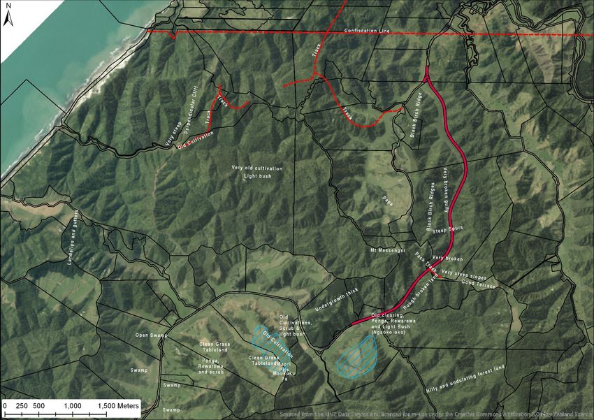
Archaeological Review: Mt Messenger Bypass Historic Heritage Assessment

Executive Summary
As part of the New Zealand Transport Agency’s (NZTA) Mt Messenger Bypass project,
an Historic Heritage Assessment (HHA) was commissioned by NZTA and prepared by
Clough and Associates (Clough & Associates, 2017) as part of the project Assessment
of Effects on the Environment(AEE) report for the project.

This review finds that the overall recommendations of the HHA fulfil the requirements
of the Archaeological Assessment of Effects and project brief, culminating in the
recommendation that a Section 44(a) authority be sought from HNZPTA.

This review has found some deficiencies with aspects of the historical overview,
heritage values and effects assessment, which should be addressed prior to an
application for an authority from HNZPT and well in advance of any earthworks taking
place for the project.

© GEOMETRIA 2017                                                                         Page 4
Archaeological Review: Mt Messenger Bypass Historic Heritage Assessment

1.0 Introduction
As part of the New Zealand Transport Agency’s (NZTA) Mt Messenger Bypass project,
an Historic Heritage Assessment (HHA) was commissioned by NZTA and prepared by
Clough and Associates (Clough & Associates, 2017) as part of the project Assessment
of Effects on the Environment(AEE) report for the project. This peer review report has
been commissioned as part of the due diligence undertaken by New Plymouth
District Council (NPDC) during the processing of the resource consent application for
the project.

This report reviews the HHA and should be read in conjunction with that report.

2.0 Methodology
This peer review is limited in scope to the original HHA. As per the HHA, it does not
specifically address waahi tapu or other places of cultural or spiritual significance to
Maori as such assessments can only be made by tangata whenua.

The methods used to review the HHA include both a desktop study and a brief
pedestrian survey of the proposed Mt Messenger Bypass route. The pedestrian survey
was undertaken with NZTA on 19 September 2017, with several other expert reviewers
for the NPDC and NPDC resource consenting staff.

The desktop survey involved an investigation of written records relating to the project
area, including regional archaeological publications and unpublished reports, New
Zealand Archaeological Association Site Record Files (NZAA SRF) downloaded via the
ArchSite website (www.archsite.org.nz), local histories, aerial photography, local
authority heritage lists, the Heritage New Zealand List and land plans held by Land
Information New Zealand and Quickmap (Custom Software Ltd., 2017). A complete
list of historic plans consulted is included in Appendix 1.

2.1 Limitations

The scope of this report was limited to reviewing the Clough and Associates HHA and
inspection of the accessible properties within the proposed route alignment where
only select areas were examined within the limited time fame. Like the surveys
undertaken for the HHA, access to the northern most property in the Mangapepeke
valley or the southern fill site in the Mimi River valley was not possible.

© GEOMETRIA 2017                                                                          Page 5
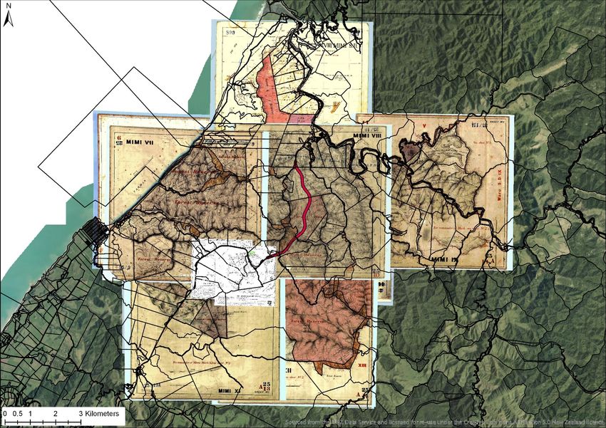
Archaeological Review: Mt Messenger Bypass Historic Heritage Assessment

3.0 Project Description
As detailed in the HHA, the primary objective of the project is to “enhance the safety,
resilience and journey time reliability of travel on SH3 and to contribute to enhanced
local and regional economic growth and productivity for people and freight”
(Clough & Associates, 2017, p. 3). The project is part of a larger SH3 improvement
project, including the SH3 Safety and Resilience Improvements Project between
Mount Messenger and the Awakino Tunnel being undertaken by Safe Roads Alliance
(Geometria Ltd., 2017) and the Awakino Tunnel Bypass Project being undertaken by
NZTA.

The proposed new SH3 alignment is east of the existing Mount Messenger SH3 that
crosses Mount Messenger (Figure 1). It passes through the Mimi and Mangapepeke
Valleys at the southern and northern ends respectively, with a tunnel below the
saddle ridge of Mount Messenger (Clough & Associates, 2017, p. 18).

The majority of the route passes through Ngati Tama land and through private farm
land at the southern and northern ends.

Figure 1: Proposed bypass route (red) and southern fill are (green). Existing road alignment in orange

© GEOMETRIA 2017                                                                                    Page 6
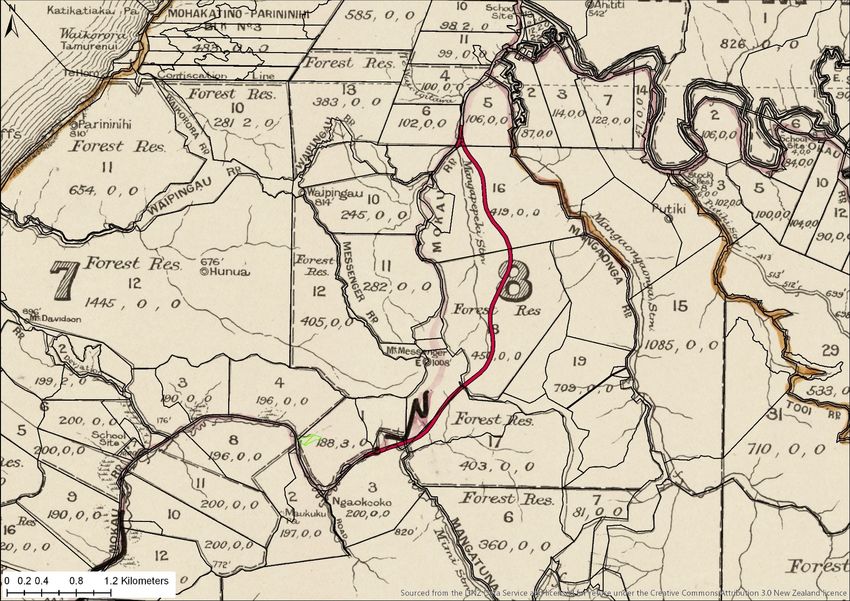
Archaeological Review: Mt Messenger Bypass Historic Heritage Assessment

4.0 Review
This review is structured in a similar manner to the Clough and Associates HHA,
addressing the sections of the original report in approximately the same order where
possible.

4.1 Methodology

The methodology of the HHA is conformant to standard archaeological practice.
The desktop survey examined similar sources to that examined by this review and is
sufficient for the purpose of the report. The visual inspection of the project area, as
described in the HHA, meets the required standard for a heritage survey, excepting
the northern most property and southern fill site that were not examined. The
northern most property is possibly an area of concern archaeologically due to the
landscape being more suitable for early occupation than the surrounding rugged
terrain. This omission has been noted in the HHA and should be addressed as early as
possible in the consenting process.

4.2 Historical Background – Maori

The HHA provides a concise overview of Maori settlement in the area, but it is helpful
to consider in more detail the occupation of the area by Maori throughout prehistory
and history, which informs the resulting historic and prehistoric landscape.
Specifically, although as the HHA notes, the project area primarily falls within the rohe
of Ngati Tama, the southern extent of the rohe of Ngati Maniapoto (part of the Tainui
confederation of tribes) is considered to be the Waipingao Stream (Maniapoto Māori
Trust Board, 2017; Te Puni Kōkiri, 2017), which encompasses most of the project area.
An iwi known as Ngati Rakei also existed historically just north of the project area in
the Mohakatino/Mokau region, an amalgamation of elements of both Ngati Tama
and Ngati Maniapoto (Wai 143, 1996, p. 279; Smith, 1910, p. 111) and noted as being
the “connecting link between Ngati-Maniapoto of “The King Country” and the Te Ati-
awa of Taranaki” (Smith, 1910, p. 98).

It is important to consider the nature of the overlapping or at least abutting tribal
boundaries, and the role it played in the occupation of the project area. Both iwi
played a role in establishing the modern archaeological landscape. The rugged
terrain of the project area played a crucial part in the defence of Taranaki from both
prehistoric and historic invasions from the north. Ngati Tama were seen as the
“gatekeepers” of Taranaki, the first line of defence against any taua (war party)
invading from the north, of which there were several, with the earliest warfare
between Ngati Tama and the Tainui tribes dating back to approximately 1625-1630.

The southern extent of the confiscation line created by the 1863 New Zealand
Settlements Act – an important historic landmark - lies less than 500m north of the
project area. The establishment of the confiscation line resulted in the taking of
approximately 122,000 acres of land north of the line, 74,000 acres of which was Ngati
Tama land with the resultant seizure having a devastating effect on iwi settlement
patterns in the area. A discussion of this feature would help inform the
archaeological potential of the area.

© GEOMETRIA 2017                                                                          Page 7
Archaeological Review: Mt Messenger Bypass Historic Heritage Assessment

Figure 2: 1863 Confiscation Line (blue), 500m north of project area (red)

© GEOMETRIA 2017                                                                                Page 8
Archaeological Review: Mt Messenger Bypass Historic Heritage Assessment

4.3 Historical Background – European

The HHA provides a broad overview of the post-colonial background of the area but
would benefit from a more detailed discussion of the development of the Main North
Road itself. This is pertinent to the discussion with respect to what will happen to the
road during the development of the bypass regarding service and lay-down areas
and possible modifications outside the main corridor identified in the HHA, as well as
identifying what will happen to the existing SH3 after development of the bypass and
any potential impacts on the historic heritage value of this section of the road.

The establishment of the road through Mount Messenger and further north through
the Awakino Gorge opened a crucial gateway to the north and was critical to the
development of the Taranaki province. Coastal shipping along the North Taranaki
coast was particularly dangerous and the newly formed road immediately served as
a valuable piece of pre-1900 infrastructure, particularly given the deficiencies of the
historic northern route along the coast, as noted in the HHA.

As noted in the HHA, work on the route dates back to as early 1883, with the initial
formation technically completed in 1898. The state of the road at the turn of the
century is evident in a 1901 photograph (Figure 3). During the late 19th century no
local suitable source of road metal was available so the metaling of the Main North
Road was achieved through the use of papa, a locally abundant soft, blue-grey
mudstone. The papa was rendered into roading metal in massive papa kilns (Figure
4), and as noted in the HHA these kilns were constructed along the roadside.
Although there are some remnants of burnt papa roads remaining, notably in
Whangamomona, very little evidence remains or has been discovered to date of this
once important industry. The papa quarries or resource locations may also be
archaeological sites and may be impacted by the proposed bypass works. The
possibility of encountering remnants of these papa kilns, original burnt papa roading
surface or papa quarry sites within the wider project area should be considered.

Figure 3: Road cutting at the base of Mt Messenger, 1901 (Auckland Weekly News Supplement, 1901, p. 4)

© GEOMETRIA 2017                                                                               Page 9
Archaeological Review: Mt Messenger Bypass Historic Heritage Assessment

Figure 4: Examples of papa kilns in Whangamomona (sources: top (Morris, 1998), bottom (Garcia, 1940))

© GEOMETRIA 2017                                                                                Page 10
Archaeological Review: Mt Messenger Bypass Historic Heritage Assessment

The HHA addresses the Mount Messenger Tunnel (Clough & Associates, 2017, p. 16),
relying on the earlier Opus report for a values assessment, which rates it as having a
“high contextual, historic and social value, moderate cultural and aesthetic value;
and potential archaeological value” (ibid.). These values however are not addressed
in the summary of results. Completed in 1918, the tunnel is significant at both a
regional and national level. The heritage values of the tunnel need to be addressed
and any potential effects on the heritage values of the feature by the proposed
works should be taken into account.

Although the HHA historical background addresses the historic formation of the road,
the heritage values of the road itself, like the tunnel, are not considered within the
values and significance discussion. The road has archaeological and historic
heritage values and the effects on these by the proposed development need to be
identified and discussed.

4.4 Historical Survey

The sources examined by the HHA are comprehensive, covering all of the pertinent
early survey plans (all c.1890-1900) for the immediate project area. In preparation of
this review the various features of the historic survey maps were marked up in a GIS,
to provide clarity regarding the relationship between noted features and the project
area. This mark-up is detailed in Table 1 and Figure 5 - Figure 8, and is discussed
below.
 Detail                                                                       Source
 Black Birch Ridge                                                            SO 25/10, SO 1969
 Black Birch Ridges                                                           SO 25/10
 Clean Grass Tableland                                                        DP 6837
 Clean Grass Tableland                                                        DP 6837
 Confiscation Line                                                            Various
 Cut track to Campbell Town                                                   SO 899
 Good Terrace                                                                 SO 25/10, SO 1969
 Hilly and undulating forest land                                             SO 25/14A
 Landslips and gutters                                                        SO 25/9
 Light bush                                                                   SO 25/9, SO 983
 Light bush with a little Puriri                                              SO 25/9
 Maori Pits                                                                   SO 864
 Maukuku Pa                                                                   DP 2946, SO 25/14A
 Mt Messenger                                                                 Various
 Old clearing, Ponga, Rewarewa and Light Bush (Ngaoko-oko)                    SO 25/14A, SO 864
 Old Cultivation                                                              SO 25/9
 Old Cultivation                                                              SO 25/9, SO 983
 Old Cultivations, Scrub & light bush                                         SO 25/23A, SO 864
 Open Swamp                                                                   SO 25/9
 Pack Track                                                                   SO 982
 Papa                                                                         SO 982
 Perpendicular Cliff                                                          SO 25/9, SO 983
 Ponga, Rewarewa and scrub                                                    SO 25/23A
 Rough broken land                                                            SO 25/10
 Steep Spurs                                                                  SO 25/10
 Swamp                                                                        SO 25/23A
 Swamp                                                                        SO 25/23A
 Swamp                                                                        SO 25/23A
 Track                                                                        SO 25/10
 Track                                                                        SO 25/10
 Track                                                                        SO 983
 Track                                                                        SO 983
 Undergrowth thick                                                            SO 25/10
 Very broken                                                                  SO 25/10, SO 1969
 Very broken gully                                                            SO 25/10, SO 1969
 Very old cultivation                                                         SO 25/9, SO 983
 Very rough and broken Papa and sandstone                                     SO 25/14A
 Very steep                                                                   SO 25/9
 Very steep slopes                                                            SO 25/10

Table 1: Detail of information recorded from survey plans, and sources (Figure 5 - Figure 8)

© GEOMETRIA 2017                                                                                   Page 11
Archaeological Review: Mt Messenger Bypass Historic Heritage Assessment

Figure 5: Plan showing location of information noted on historic survey plans

© GEOMETRIA 2017                                                                                Page 12
Archaeological Review: Mt Messenger Bypass Historic Heritage Assessment

Figure 6: Plan showing location of information noted on historic survey plans for southern half of project
area

© GEOMETRIA 2017                                                                                      Page 13
Archaeological Review: Mt Messenger Bypass Historic Heritage Assessment

Figure 7: Plan showing location of information noted on historic survey plans for northern half of project
area

© GEOMETRIA 2017                                                                                      Page 14
Archaeological Review: Mt Messenger Bypass Historic Heritage Assessment

Figure 8: Location and coverage of the plans utilised in this review (project area in red)

© GEOMETRIA 2017                                                                                Page 15
Archaeological Review: Mt Messenger Bypass Historic Heritage Assessment

Figure 9: c.1900 Roll Plan in the vicinity of the project area (red)

© GEOMETRIA 2017                                                                                  Page 16
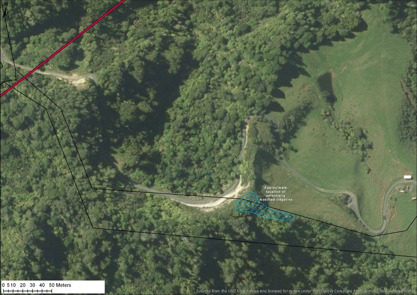
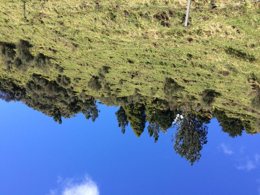
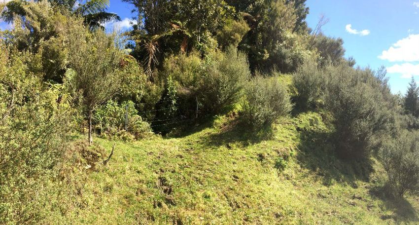
Archaeological Review: Mt Messenger Bypass Historic Heritage Assessment

The HHA notes many of the various features noted in the historic plans, all of which
are within relatively close proximity to the project area. Much of the project area is
described in the maps as “very broken”, “steep spurs”, “swamps”, with some notable
anthropogenic features such cultivations and clearings noted near the southern end
of the project area, as well as Maukuku Pa (Q18/74) and related pits (Figure 6). To
the north east of the project area (Figure 7) a number of tracks are noted, which
were the tracks used by early surveyors, but likely match early Maori tracks. As noted
in the HHA, a further pack track leads from the current Mount Messenger rest area,
leading to a “good terrace”.

In addition to the plans studied by the HHA, this review examined the c.1900 Roll Plans
for the area (Figure 9) but no more information was present beyond what is included
in the more detailed survey plans already examined, which is to be expected given
that the Roll Plans summarise and derive from the more detailed survey plans of the
period.

The relevant historic plan information is assessed by the HHA as providing relatively
limited information, with the conclusion being that the chance of encountering
archaeological sites would be low and those encountered would not be significant
(Clough & Associates, 2017, pp. 25-26).

4.5 Field Investigation

The description of the field survey undertaken for the HHA was appropriate for the
project, the noted exception being the northern most property where landowner
permission for access was denied at the time of survey.

Similarly, site and time restrictions during the field visit for this review meant a
comprehensive pedestrian survey was not possible. However, one area of possible
concern was noted along the historic pack track from the rest area at the top of
Mount Messenger (Figure 10). The ridgeline above the modern access road
(originally the pack track) shows some evidence of anthropogenic modification.

The top of this ridgeline exhibits signs of terracing and two possible transverse
defensive ditches (Figure 11 - Figure 13) which may indicate an unrecorded
archaeological site. The features are smoothed and amorphous in form and may be
naturally occurring geomorphological features, although the ditches are
comparable to eroded ditches commonly found on archaeological sites elsewhere
in North Taranaki. This ridgeline has been grazed by cattle and the ground surface
has been heavily disturbed.

Thick bush covers the southern half of the site as well as the ridgeline beyond the
western ditch, but due to time constraints during the site visit these areas could not
be examined in detail, so the nature of the features could not be conclusively
determined. It is unclear whether this area was examined during the HHA and
discounted as being archaeological but if not, it would warrant further investigation.
This location is one of the highest points east of Mount Messenger, providing an
exceptional viewshed down the Mangapepeke valley to the north and the Mimi
valley to the south, across the Mount Taranaki. These views are approximated
through Goole Earth in Figure 14 and Figure 15, but do not take into account that the
area was heavily forested throughout most of history and prehistory.

Assuming that the historic pack track was originally a Maori ara (pathway) this
location would have been suitable for either a small pa or defended sentry post, with
exceptional natural defences and sight lines providing protection to the “good
terraces” noted on SO 25/10 and SO 1969 (which were not examined during this
review).

© GEOMETRIA 2017                                                                          Page 17
Archaeological Review: Mt Messenger Bypass Historic Heritage Assessment

This location appears to be well enough removed from any works related to the
proposed bypass route to be of no great concern, but the HHA should address any
potential implications for this site, if it does turn out to be a pa upon further inspection.

Figure 10: Possible pa site noted down pack track from Mount Messenger area

© GEOMETRIA 2017                                                                              Page 18
Archaeological Review: Mt Messenger Bypass Historic Heritage Assessment

                                                         Terrace ?

Figure 11: Photograph looking east along possibly modified ridgeline above access road from rest area.

                                           Ditch

Figure 12: Photograph looking west at possible ditch on ridgeline, above access road from rest area.

© GEOMETRIA 2017                                                                                  Page 19
Archaeological Review: Mt Messenger Bypass Historic Heritage Assessment Figure 13: Photograph looking south, up from access track to possibly modified ridgeline Figure 14: Approximated modern view north from modified ridgeline, generated in Google Earth. Mangapepeke Valley noted in center and SH3 on left of frame. © GEOMETRIA 2017 Page 20
Archaeological Review: Mt Messenger Bypass Historic Heritage Assessment

Figure 15: Approximated modern view south from modified ridgeline, generated in Google Earth. Mimi
Valley and Mount Taranaki both visible in center of frame.

4.6 Discussion and Conclusions

The assessment and subsequent conclusions reached by the HHA would benefit from
further consideration of the wider archaeological landscape. The HHA concludes
that “the steep bush country around Mount Messenger would generally have been
unsuitable for Maori settlement, which was focussed along the coastal plains, but
would have provided a source of raw materials” (Clough & Associates, 2017, p. 25).

The rugged nature of the interior environment, such as the subject area, was not
necessarily a hindrance to Maori occupation. There are many instances 1 where the
nature of this environment was precisely what attracted Maori to settle – such as
isolation and protection from the coastal traffic and exodus from the land during
times of strife.

There are a number of sites in the immediate vicinity of the project area, which
despite the rugged terrain, together suggest an archaeological landscape relatively
rich in occupation. Immediately south of the project area lies an extensive
occupation area, that consists of a large area of cultivations 2 and pits, guarded by
Maukuku Pa (Q18/74). The named clearing Ngaoko-oko (Figure 6) indicated on
numerous maps is also indicative of likely occupation 3. West of the project - between
Mount Messenger and the coast – are numerous cultivations noted on historic plans in
an otherwise extremely rugged landscape, some noted as “very old”. Similarly North
of the project area is a densely occupied archaeological landscape 4 and the same
is true immediate South of the project area.

It seems more likely that the lack of recorded archaeological sites in the Mount
Messenger area is the result of a more limited occupation of the interior in pre-historic

1 For a detailed discussion of this point, refer to Appendix 2.
2 On these early plans “cultivations” generally refers to Maori gardens
3 Named locations such as Ngaoko-oko were often important sites, significant enough that they were

known of by surveyors, or pointed out by Maori guides to surveyors at the time, in this case quite possibly by
the Maori chief Ephia, who accompanied W.H Skinner in his early surveys in this area from 1876 (Skinner,
1946, pp. 35-41)
4 For a detailed discussion of this area refer to Geometria Ltd., 2017

© GEOMETRIA 2017                                                                                     Page 21
Archaeological Review: Mt Messenger Bypass Historic Heritage Assessment

times, a limited knowledge of the Maori history of the area and also a dearth of
archaeological recording, rather than a lack of evidence. The difficult terrain,
combined with late period European land tenure and a low developmental pressure
has resulted in very little intensive archaeological research being conducted in the
area historically.

While it was certainly unfavourable for settlement, it was clearly not a complete
barrier. The rugged terrain offered land suitable for defensive purposes and
numerous examples exist of northern Taranaki pa or settlements in extremely rugged
and nearly inaccessible back country environments, often having been established
specifically to exploit the very nature of the terrain to advantage. Such sites are
often “retreat” or “refuge” pa, known through oral tradition (Ngati Tama, 2008-2014,
Ngati Mutunga, 2008-2017) to have been used as retreat positions for women,
children and elderly during times of war. There are a number of sites 5 very close to
the project area in similar terrain to what the HHA refers to as “unsuitable for Maori
settlement”.

The HHA suggests that, as a minimum, the area would have been used as a “source
of raw materials” (Clough & Associates, 2017, p. 25), but does not give great detail on
the archaeological potential, or “significance” of the project area, and specifically
the areas proximate to the historically mapped features. The HHA suggests that the
area was primarily a source of raw materials, and if this was the case then one would
expect associated archaeological sites in the vicinity of the resource locations. 6

As noted in the HHA, the northern most property could not be examined, but this
area holds some of the greatest potential for unrecorded archaeological sites being
encountered during the project. It is recommended that this be addressed as soon
as possible in the resource consenting period.

The HHA briefly touches on the heritage values of the Mount Messenger tunnel
(Clough & Associates, 2017, pp. 25-26), but does not consider them in the overall
heritage values assessment. In addition, no mention is made of the heritage values of
the road itself or impacts that the proposed bypass may have on these. Much of the
early road over Mount Messenger was constructed prior to 1900, and remains to this
day a significant regional infrastructure achievement. The development of the road
opened Taranaki to the north and was a crucial milestone in the economic
development of the region.

The possibility of disturbing the remnants of the original burnt papa road, or the papa
kilns should be addressed in the HHA. Infrastructure sites such as these have a
relatively low representation in the archaeological record and thus may warrant
being afforded a higher significance.

The discussion of archaeological effects would also be better informed by
referencing detailed plans of the proposed works, which may not have been
available at the time of writing the HHA. It is critical that the HHA assesses the specific
details of the proposed works, in addition to the more general effects already
covered. This should extend to discussion of any auxiliary developments, such as the
development of access roads for heavy machinery 7, heavy machinery storage areas,
electrical and/or water infrastructure installation, fencing and vegetation removal if
applicable.

5 As discussed in Appendix 2.
6 As discussed in Appendix 3.
7 Such as the proposed access road down from SH3 required for the creation of the proposed tunnel

© GEOMETRIA 2017                                                                               Page 22
Archaeological Review: Mt Messenger Bypass Historic Heritage Assessment

4.7 Effects of the proposal

The overall recommendations of the HHA are sound. As noted it is crucial that the
unsurveyed areas be examined in the Mangapepeke Valley and the southern fill site
prior to the works program commencing. The list of likely archaeological features
should be expanded to include remnants of the original burnt papa road, papa kilns
and early settlements associated with the road’s construction.

The recommendation that archaeological monitoring take place under a Section
44(a) authority during initial earthworks is pertinent, as this will enable works that might
result in the discovery of any previously unrecorded archaeological sites to proceed
under archaeological supervision. It is recommended that an overall Archaeological
Works Plan be developed, as part of the authority process, to ensure clarity regarding
how earthworks should proceed to best mitigate damage to any previously
unrecorded archaeological sites.

5.0 Conclusion
The overall recommendations of the HHA fulfil the requirements of the Archaeological
Assessment of Effects and project brief, culminating in the recommendation that a
Section 44(a) authority be sought from HNZPTA. This review has found some minor
deficiencies with aspects of the historical overview, heritage values and effects
assessment. These issues, which may need to be addressed, are:

    1. The northern-most property and southern fill site needs to be fully assessed.

    2. The heritage values of the original burnt-papa road, Mount Messenger tunnel,
       papa kilns and papa quarries should be assessed and mitigation discussed.

    3. A wider landscape view should be considered when assessing the likelihood
       of encountering unrecorded archaeological sites in the project area. The
       HHA determines the landscape to be unsuitable for occupation, but other
       similar landscapes in North Taranaki are well populated with archaeological
       sites.

    4. A potential site above the pack track from the Mount Messenger rest area
       should be investigated further.

It is recommended that these issues be addressed both prior to an application for an
authority from HNZPT and also under authority from HNZPT if required, and well in
advance of any earthworks taking place for the project.

© GEOMETRIA 2017                                                                           Page 23
Archaeological Review: Mt Messenger Bypass Historic Heritage Assessment
Bibliography
Auckland Weekly News Supplement. (1901, April 19). Auckland Weekly News
Supplement.
Byrnes, G. (1995). Wai 143: Ngati Tama Ancillary Claims. Waitangi Tribunal, Wellington.
Clough & Associates. (2017). Mt Messenger Bypass: Historic Heritage Assessment.
Unpublished report to NZTA.
Custom Software Ltd. (2017). QuickMap. Computer Software.
Garcia, J. (1940). History of Whangamomona County.
Geometria Ltd. (2017). Archaeological Assessment of Effects: State Highway 3 –
Awakino Gorge to Mt Messenger Corridor. Unpublished report to Safe Roads
Alliance.
Hooker, R. (1971). Field Research in the Inland Taranaki Region. Archaeology in New
Zealand, Vol. 14, No. 4, 142-156.
Maniapoto Māori Trust Board. (2017, September 25). Retrieved from
http://www.maniapoto.iwi.nz/about-us/rohe-map/
Morris, D. (1998). Marco School and District Centennial.
Ngati Mutunga. (2008-2017). Personal Communications during Waahi Tapu Review
Project, New Plymouth District Council.
Ngati Tama. (2008-2014). Personal Communications during Waahi Tapu Review
Project, New Plymouth District Council.
Potts, K. (2015). SH3 Awakino Gorge to Mount Messenger Corridor. Preliminary
Archaeoogical Appraisal. Unpublished report to New Zealand Transport
Agency.
Skinner, W. (1946). Reminiscences of a Taranaki Surveyor, New Plymouth.
Smith, S. P. (1910). History and Traditions of the Maoris of the West Coast North Island
of New.
Stokes, E. (1988). Mokau: Maori Cultural and Historical Perspectives, University of
Waikato.
Te Ara. (2017, September). Story: Ngāti Maniapoto. Retrieved from
https://teara.govt.nz/en/ngati-maniapoto/page-1
Te Puni Kōkiri. (2017, October 3). Tainui Maniapoto. Retrieved from Te Kāhui Māngai:
Directory of Iwi and Maori Organisations: http://www.tkm.govt.nz/iwi/ngati-
maniapoto/
Wai 143. (1996). The Taranaki report : kaupapa tuatahi (Wai 143) New Zealand.
Waitangi Tribunal.
© GEOMETRIA 2017 Page 24Archaeological Review: Mt Messenger Bypass Historic Heritage Assessment Appendix 1: List of historic survey plans consulted The following plans (Table 2) were consulted during the creation of this report. The plans that provided information relevant to the report are listed as “Used” Examined Used NPC DP 5188 NP DP 2946 NPC SO 10099 NP DP 6837 NPC SO 10123 NPC SO 1037 NPC SO 1038 NPC SO 1969 NPC SO 1327 NPC SO 25 10 NPC SO 25 1 NPC SO 25 11A NPC SO 338 NPC SO 25 13A NPC SO 339 NPC SO 25 14A NPC SO 52 12 NPC SO 25 9 NPC SO 52 4 NPC SO 864 NPC SO 6686 NPC SO 899 NPC SO 7509 NPC SO 982 NPC SO 867 NPC SO 983 NPC SO 8987 NPC SO 8998 NPC SO 9531 NPC SO 9532 NPC SO 9678 NPC SO 9753 NPC SO 9860 NPC SO 9974 NP DP 3558 NP DP 4916 NP DP 5353 NP DP 5816 NP SO 10371 NP SO 10529 NP SO 10531 NP SO 10532 NP SO 1106 NP SO 11535 NP SO 11536 NP SO 12007 NP SO 12071 NP SO 12218 NP SO 13040 NP SO 13040 NP SO 13158 NP SO 13910 NP SO 2773 NP SO 6871 NP SO 7978 NP SO 8480 NP SO 8986 NP SO 9107 NP SO 9512 NP SO 9532 Table 2: List of historic survey plans consulted © GEOMETRIA 2017 Page 25
Archaeological Review: Mt Messenger Bypass Historic Heritage Assessment
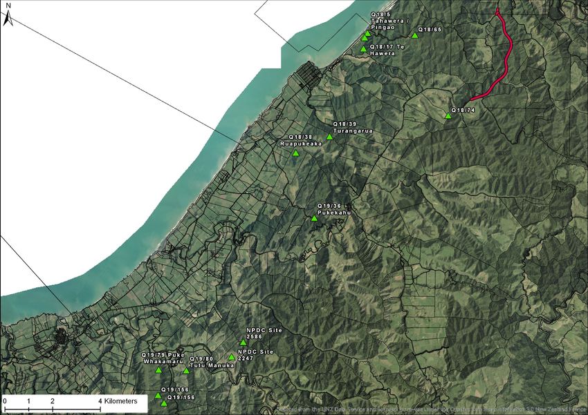
Appendix 2: Discussion on Northern Taranaki sites within rugged landscapes
There are a number of sites proximate to the project area in similar terrain to what the
HHA suggests as “unsuitable for Maori settlement” (Table 3). Within the wider
Northern Taranaki landscape there are many more examples of occupation sites
within very rugged terrain, some very similar to the project area. Table 4 and Figure
16 detail some relevant examples within the Ngati Mutunga rohe (of which the review
author has personal experience).
Although these sites are obviously cherry-picked, they demonstrate that the terrain of
the project area does not preclude unrecorded sites being present. The
pa/settlement complex of Puke Whakamaru (Q19/79, Q19/156) is probably the most
impressive example of a nearly identical landscape to the project area being utilised
both for a settlement and a defensive refuge pa. The terrain makes the pa nearly
inaccessible without safety ropes, but the larger settlement area occupies a gently
sloping clearing, very similar to those noted in plans near the project area.
NZAA Site Detail
Q18/65 A large area (1km2) containing cultivations, in steep, thickly bushed mountain range.
Q18/74 Maukuku Pa, a single platform pa with terrace and pits. Cultivations in nearby slopes.
Q18/17 Te Hawera Pa. A terraced pa site on a steep ridgeline overlooking the Waipingao
valley, in thick bush
Q18/5 Tahawera (or Pingao) Pa. Terraced pa on steep ridgeline above coast. Site
realistically extends along several nearby ridgelines, with several pits, fire features and
clearings encountered. Very rugged, steep terrain.
Table 3: Lists of relevant NZAA sites in immediate vicinity of project area
NZAA Site Detail
Q19/79 The most similar in environment to the project area, Puke Whakamaru consists of a large
settlement area (700m x 350m) in a clearing in otherwise rugged bush.
Q19/156 Further back along the ridgeline from the Q19/79, the associated pa site Q19/156 is
accessible only by way of extremely steep, narrow ridges (requiring safety ropes in
places), but functioned as a hidden refuge pa, for retreat in times of war. There is
reportedly another pa site even deeper into the bush along the same ridgeline but this
was not found during the visit to Q19/156.
Q19/36 Pukekahu is a ridge top pa on a steep, isolated ridgeline in otherwise thick bush.
Q18/39 Turangarua is an extensive pa site with defensive earthworks on a huge, sprawling,
series of steep ridgelines, similar to the project area, in thick bush.
Q19/38 Ruapukeaka Pa. A terraced pa site, on a steep, forested ridgeline, with small central
platform.
Q19/80 Tutu Manuka Pa. An extensive hilltop pa defended by very steep bluffs, accessed via
steep ridgelines.
NPDC DP A pa extending some 350m along a thickly forested, steep ridge, spatially associated
2586 with settlement site NPDC DP 2247.
NPDC DP An extensive settlement, consisting of several terraces with pits and house sites. Would
2247 have likely originally been a clearing in thick forest.
Table 4: List of significant sites 8 in very similar terrain to project area, in North Taranaki, south of project area.
8NPDC DP sites are archaeological or waahi tapu sites have been recorded during the New Plymouth
District Council District Plan Upgrade Project, but have not yet included in the NZAA ArchSite list
© GEOMETRIA 2017 Page 26Archaeological Review: Mt Messenger Bypass Historic Heritage Assessment Figure 16: Plan showing locations of archaeological sites referred to in text © GEOMETRIA 2017 Page 27
Archaeological Review: Mt Messenger Bypass Historic Heritage Assessment

Appendix 3: Discussion on the archaeology of Te Wera
The HHA suggest that the project area would have “provided a source of raw
materials” (Clough & Associates, 2017, p. 25) and if this is indeed the case, this likely
increases the chance of encountering archaeological sites related to resource
gathering activities.

If the area was a resource gathering area, a useful comparison is the inland
landscape of Te Wera forest, which was significant as a resource location in
prehistory, and was extensively surveyed in 1969 by Ray Hooker. The region is within
the rohe of Ngati Maru.

The Te Wera landscape is similar to that of the project area, with steep ridgelines, lush
sometimes swampy valley floors, a difficult geology dominated by a form of papa
mudstone and in the archaic period was almost entirely valued for its resource value,
being a source of good adze stone. In spite of these limiting factors, an abundance
of sites was found during intensive survey of the area, primarily short-term settlements
(seasonal camps in the narrow valleys between steep ridgelines), resource locations
and small pa on steep ridgelines (Hooker, 1971). Although the remoteness of Te Wera
distinguishes it from the project area, it is indicative that even largely undesirable
landscapes, which functioned primary as a resource location still exhibit signs of
occupation that can be studied through archaeological methods.

© GEOMETRIA 2017                                                                           Page 28
You can also read