MUSEUM OF NEW MEXICO OFFICE OF ARCHAEOLOGICAL STUDIES ARCHAEOLOGICAL SURVEY OF MOON MOUNTAIN IN RUIDOSO, LINCOLN COUNTY, NEW MEXICO - Yvonne R ...
←
→
Page content transcription
If your browser does not render page correctly, please read the page content below
MUSEUM OF NEW MEXICO

   OFFICE OF ARCHAEOLOGICAL STUDIES

ARCHAEOLOGICAL SURVEY OF MOON MOUNTAIN
  IN RUIDOSO, LINCOLN COUNTY, NEW MEXICO

              Yvonne R. Oakes

                   Timothy D. Maxwell
                  Principal Investigator

            ARCHAEOLOGY NOTES 306

       SANTA FE         2002        NEW MEXICO
ADMINISTRATIVE SUMMARY

    The Office of Archaeological Studies (OAS) of the Museum of New Mexico conducted an archaeo-
logical inventory survey for the New Mexico State Land Office between April 8 and 12, 2002. The survey
was performed on lands owned by the State Land Office, which proposes to reduce the density of the heavy
forest on the land in a 300-yard buffer zone around existing houses at the base of Moon Mountain near
Ruidoso. The reason for the tree-thinning is to reduce the threat of wildfires in the mountain community.
    The archaeological survey covered approximately 267.5 acres of steep, densely wooded lands. One
previously unrecorded site, LA 135599, was inventoried. It consisted of the remains of a disassembled
tramway tower dating from the early to late 1950s. The site is not considered eligible for inclusion on the
National Register of Historic Places. Two isolated occurrences of lithic artifacts were also encountered and
documented.
    This undertaking complies with the National Historic Preservation Act of 1966, as amended through
1992, and applicable regulations. The report is consistent with applicable federal and state standards for
cultural resource management.

Submitted in fulfillment of a contract between the Office of Archaeological Studies of the Museum of New
Mexico and the New Mexico State Land Office.

MNM Project 41.697
NMCRIS No. 78612

                                                    iii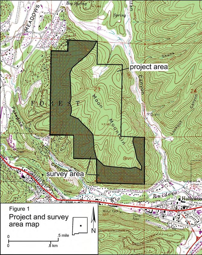
CONTENTS
ADMINISTRATIVE SUMMARY . . . . . . . . . . . . . . . . . . . . . . . . . . . . . . . . . . . . . . . . . . . . . . . . . . . iii
INTRODUCTION . . . . . . . . . . . . . . . . . . . . . . . . . . . . . . . . . . . . . . . . . . . . . . . . . . . . . . . . . . . . . . . 1
The Project Area . . . . . . . . . . . . . . . . . . . . . . . . . . . . . . . . . . . . . . . . . . . . . . . . . . . . . . . . . . . . . . 1
Project Personnel and Summation . . . . . . . . . . . . . . . . . . . . . . . . . . . . . . . . . . . . . . . . . . . . . . . . . 1
ENVIRONMENT . . . . . . . . . . . . . . . . . . . . . . . . . . . . . . . . . . . . . . . . . . . . . . . . . . . . . . . . . . . . . . . . 3
Geology and Soils . . . . . . . . . . . . . . . . . . . . . . . . . . . . . . . . . . . . . . . . . . . . . . . . . . . . . . . . . . . . . 3
Vegetation and Wildlife . . . . . . . . . . . . . . . . . . . . . . . . . . . . . . . . . . . . . . . . . . . . . . . . . . . . . . . . . 3
Climate . . . . . . . . . . . . . . . . . . . . . . . . . . . . . . . . . . . . . . . . . . . . . . . . . . . . . . . . . . . . . . . . . . . . . 3
CULTURAL OVERVIEW . . . . . . . . . . . . . . . . . . . . . . . . . . . . . . . . . . . . . . . . . . . . . . . . . . . . . . . . . 9
Paleoindian Period . . . . . . . . . . . . . . . . . . . . . . . . . . . . . . . . . . . . . . . . . . . . . . . . . . . . . . . . . . . . 9
Archaic Period . . . . . . . . . . . . . . . . . . . . . . . . . . . . . . . . . . . . . . . . . . . . . . . . . . . . . . . . . . . . . . . 9
Ceramic Period . . . . . . . . . . . . . . . . . . . . . . . . . . . . . . . . . . . . . . . . . . . . . . . . . . . . . . . . . . . . . . 10
Athabaskan Period . . . . . . . . . . . . . . . . . . . . . . . . . . . . . . . . . . . . . . . . . . . . . . . . . . . . . . . . . . . 12
Historic Occupation . . . . . . . . . . . . . . . . . . . . . . . . . . . . . . . . . . . . . . . . . . . . . . . . . . . . . . . . . . 13
Previous Work in the Area . . . . . . . . . . . . . . . . . . . . . . . . . . . . . . . . . . . . . . . . . . . . . . . . . . . . . 13
FIELD METHODS . . . . . . . . . . . . . . . . . . . . . . . . . . . . . . . . . . . . . . . . . . . . . . . . . . . . . . . . . . . . . . 15
SURVEY RESULTS . . . . . . . . . . . . . . . . . . . . . . . . . . . . . . . . . . . . . . . . . . . . . . . . . . . . . . . . . . . . . 17
LA 135599 . . . . . . . . . . . . . . . . . . . . . . . . . . . . . . . . . . . . . . . . . . . . . . . . . . . . . . . . . . . . . . . . . 17
Isolated Artifacts . . . . . . . . . . . . . . . . . . . . . . . . . . . . . . . . . . . . . . . . . . . . . . . . . . . . . . . . . . . . . 17
Summary . . . . . . . . . . . . . . . . . . . . . . . . . . . . . . . . . . . . . . . . . . . . . . . . . . . . . . . . . . . . . . . . . . 18
RECOMMENDATIONS . . . . . . . . . . . . . . . . . . . . . . . . . . . . . . . . . . . . . . . . . . . . . . . . . . . . . . . . . . 21
LA 135599 . . . . . . . . . . . . . . . . . . . . . . . . . . . . . . . . . . . . . . . . . . . . . . . . . . . . . . . . . . . . . . . . . 21
Isolated Occurrences . . . . . . . . . . . . . . . . . . . . . . . . . . . . . . . . . . . . . . . . . . . . . . . . . . . . . . . . . . 21
REFERENCES CITED . . . . . . . . . . . . . . . . . . . . . . . . . . . . . . . . . . . . . . . . . . . . . . . . . . . . . . . . . . . 23
APPENDIX 1: SITE LOCATION INFORMATION . . . . . . . . . . . . . . . . . . . . . . . . . . . . . . . . . . . . . 29
FIGURES
1. Project and survey area map. . . . . . . . . . . . . . . . . . . . . . . . . . . . . . . . . . . . . . . . . . . . . . . . . . . . . . . 2
2. Forested lands of survey area . . . . . . . . . . . . . . . . . . . . . . . . . . . . . . . . . . . . . . . . . . . . . . . . . . . . . . 4
3. Sierra Blanca Peak from project area . . . . . . . . . . . . . . . . . . . . . . . . . . . . . . . . . . . . . . . . . . . . . . . . 4
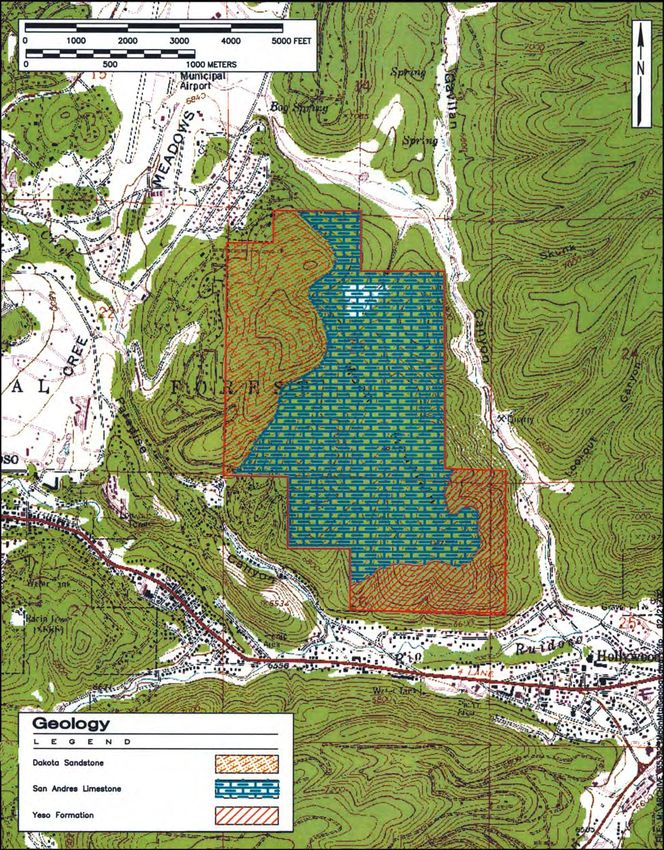
4. Geologic divisions of Moon Mountain . . . . . . . . . . . . . . . . . . . . . . . . . . . . . . . . . . . . . . . . . . . . . . . 5
5. Soils of Moon Mountain . . . . . . . . . . . . . . . . . . . . . . . . . . . . . . . . . . . . . . . . . . . . . . . . . . . . . . . . . 6
6. Vegetation associations of Moon Mountain . . . . . . . . . . . . . . . . . . . . . . . . . . . . . . . . . . . . . . . . . . . 7
7. The Moon Mountain Skyway . . . . . . . . . . . . . . . . . . . . . . . . . . . . . . . . . . . . . . . . . . . . . . . . . . . . . 17
8. Plan of LA 135599. . . . . . . . . . . . . . . . . . . . . . . . . . . . . . . . . . . . . . . . . . . . . . . . . . . . . . . . . . . . . 18
9. One of the large boards strewn across site . . . . . . . . . . . . . . . . . . . . . . . . . . . . . . . . . . . . . . . . . . . 19
10. Housing for machinery may have stood here . . . . . . . . . . . . . . . . . . . . . . . . . . . . . . . . . . . . . . . . 19
11. Projectile point with serrated edges . . . . . . . . . . . . . . . . . . . . . . . . . . . . . . . . . . . . . . . . . . . . . . . 21
TABLES
1. Weather statistics from nearby stations . . . . . . . . . . . . . . . . . . . . . . . . . . . . . . . . . . . . . . . . . . . . . . . 8
v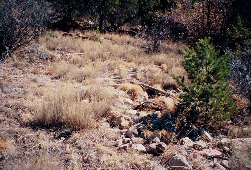
INTRODUCTION                                     State Land Office. TRC, of Albuquerque, New Mexico,
                                                                 contracted with them to perform the tree-thinning. Mr.
     The archaeological survey was conducted on State            Martin Martinez provided the OAS with maps of the
Land Office lands adjacent to the village of Ruidoso,            areas to be reduced.
where tree reduction is deemed necessary to enhance                   The project area is within portions of Sections 23
public safety and protect the community's economic               (230.2 acres) and Section 26 (37.2 acres), Township 11
security. There has been an increasing number and                S, Range 13 E, UTM Zone 13 (Fig. 1).
intensity of wildfires in the western United States, and
in 2000 to 2002, several large fires occurred in the                      PROJECT PERSONNEL AND SUMMATION
immediate vicinity of Ruidoso, including the Cree,
Gavilan, and Kokopeli fires.                                          The project director was Yvonne Oakes, assisted by
     Besides wildfires, western forests are also in poor         Dorothy Zamora and Phil Alldritt. Stephen Post and Ann
health from catastrophic insect infestation and outbreaks        Noble prepared the maps and figures. Archaeological
of disease (Oakes 2001). Poor forest health is identified        work was conducted for the State Land Office on Moon
by increased density of small-diameter trees, interrup-          Mountain, Ruidoso, New Mexico. One site, LA 135599,
tion in normal species succession by competition for             and two isolated artifacts were recorded. The site con-
water and light, and increasing frequency and damage             sists of the scattered remains of a tramway that extend-
from insect and disease occurrences.                             ed from the main street of Ruidoso to the top of Moon
     The Ruidoso area is suffering from these poor for-          Mountain. Based on local informants, the tram was in
est conditions. The village is considered to be at partic-       use from the early to late 1950s. The site can be avoid-
ular risk because of its proximity to forested lands,            ed during implementation of the tree-reduction project.
which are heavily utilized seasonally by visitors to the         Site location information is provided in Appendix 1.
community. As a result, there is a potential for intense              Most of the surveyed land was on moderate to very
fires in these areas.                                            steep slopes of heavily forested lands. The purpose of
                                                                 the project was to identify all cultural resources (sites
                   THE PROJECT AREA                              and isolated artifacts) within the project area. Measures
                                                                 to alleviate any adverse effects to the one recorded site,
     Between April 8 and April 12, 2002, the Office of           LA 135599, that might occur through clearing of these
Archaeological Studies (OAS) conducted a comprehen-              lands are presented in this report.
sive, systematic pedestrian survey of 267.5 acres of                  This undertaking complies with the provisions of
State Land Office property on Moon Mountain in the               the National Historic Preservation Act of 1966, as
village of Ruidoso in Lincoln County, New Mexico. It             amended through 1992, and applicable regulations. This
took place within a 300-yard buffer zone around exist-           report is consistent with applicable federal and state
ing structures at the base of the mountain. The survey           standards for cultural resource management.
was undertaken at the request of Mr. Robert Jenks of the

                                                             1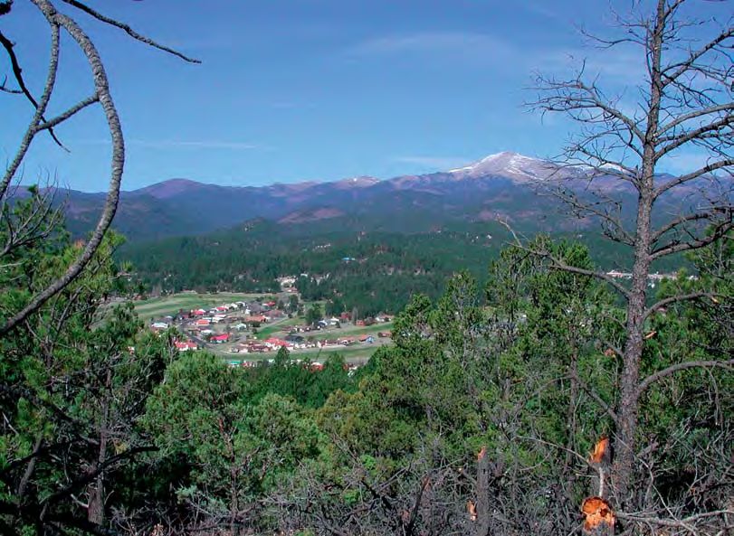
2
ENVIRONMENT Tortugas soils are loamy, carbonaceous, and mesic.
They are very shallow to shallow and are well-drained.
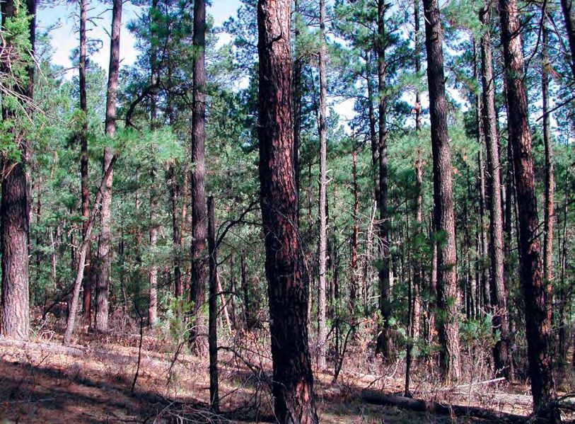
Within the 267.5 acres of surveyed land on Moon The soils are formed from limestone and are found on
Mountain, the character of the topography varied most- mountain sides, hills, and other uplands at slopes of 0-
ly by degree of steepness on the different slopes of the 75 percent. Elevation ranges from 5,000 to 7,500 ft.
project area. Moderate slopes are found along with Limestone outcrops in these soils at a depth of 6-20
many very steep inclines. All lands are heavily forested inches.
(Fig. 2), some with more duff, and others with more
scrub oak. Several dry arroyos found along the southern VEGETATION AND WILDLIFE
edges drain the area in times of heavy precipitation. The
Rio Ruidoso is the closest perennial stream, flowing The Ruidoso area has a great variety of potential
approximately 1/4 mi south of the base of Moon economic resources that cross between the Rocky
Mountain. Mountain conifer forest and Great Basin conifer wood-
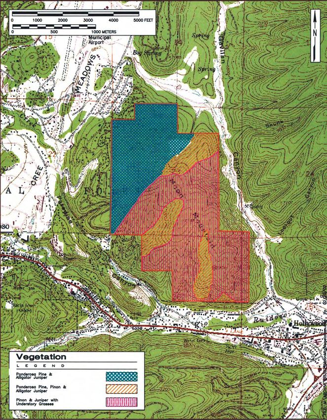
The project area lies just east of Sierra Blanca Peak land biotic communities (Brown 1994:52-57; Case
in the Sierra Blanca mountain range within the 1994:49-51), varying in appearance with elevation and
the steepness of the slope (Fig. 6). In the area, stands of
Sacramento section of the Basin and Range physio-
piñon and juniper quickly grade into Ponderosa pine as
graphic province (Fenneman 1931:394). The elevation
one moves upslope. The mountain soils support mostly
of the surveyed area ranges from 6,640 ft (2,023.8 m) to
Ponderosa pine, fir, aspen, spruce, mountain mahogany,
7,300 ft (2,225.0 m). Sierra Blanca Peak dominates the
oak brush, piñon, and juniper (Akins 1997:4). Gambel's
surrounding landscape (Fig. 3) at 12,003 ft (3,660 m).
oak is common. Ground cover consists mostly of grama
grasses, brome, and bluegrass, as well as wildflowers,
GEOLOGY AND SOILS
including sunflower, thistle, and Indian paintbrush.
Alligator juniper, small ferns, rabbitbrush, mullein, and
The project area lies within the northern
wild rose are observed on this project were also.
Sacramento Mountains, one of the largest mountain
The habitat in the project area is excellent for
ranges in southern New Mexico. The northern part of wildlife, including elk, bear, and turkey. Deer, prong-
these mountains, the Sierra Blancas, is composed most- horn, and rabbit are supposedly less common (Nehrer
ly of igneous rocks. Within the survey area are Permian 1976:46). However, numerous deer and rabbits were
age limestones of the Yeso formation, San Andres lime- observed on survey as well as wild turkey. Mountain
stone, and Dakota sandstone of Cretaceous age (Walt lions, foxes, porcupines, bobcats, and coyotes may also
1980:8,11; Fig. 4). be expected to be present (Human Systems Research
Soils on Moon Mountain are varied and complex 1973).
(Fig. 5). Five soil types are present (Sprankle 1983).
Monjeau soils are fine and mesic. They are well-drained CLIMATE
and derived mainly from sandstone, siltstone, andesite,
or shale. This type is found on ridge tops and mountain (adapted from Alldritt 2000)
sides with slopes of 8-75 percent. Elevation usually
ranges from 7,000 to 7,500 ft. The variability of the Ruidoso topography indicates
Docdee soils are mesic and very shallow to shallow. that elevation is the key determinant of precipitation and
They are well-drained and derived mainly from sand- temperature (Prince 1980:18). Sites in lower, more level
stone and andesite. This type occurs on ridge tops and terrain are subject to less severe weather than sites in the
mountain sides with slopes of 8-75 percent. The eleva- mountains and narrow valleys surrounding Ruidoso
tion ranges from 7,000 to 7,500 ft. (Table 1). These mountain and canyon areas experience
Paco soils are also fine and mesic. They are deep extremes in temperatures and, by channeling air move-
and well-drained, formed in residuum and local alluvi- ment, create their own rapidly changing temperature
um. The soils are found in upland valleys and on toe fluctuations. For example, in only two hours the tem-
slopes of 3-30 percent. Elevation ranges from 6,200 to perature can drop from 68 degrees F to freezing (Tuan
7,500 ft. et al. 1973:69-79).
Penapon soils are loamy and mesic. They are very Most precipitation generally occurs in the form of
deep and well-drained, formed in alluvium and colluvi- summer thundershowers. The frost-free season is short
um derived mainly from sandstone. The soils are found at Ruidoso, with a recorded average of 102 days and a
on mountain sides and on alluvial fans with 8-75 percent standard deviation of 18 days. Rainfall in this area is
slopes and at 6,600-7,500 ft elevations. among the highest in the state, with exposed slopes
3Figure 2. Forested lands of survey area.
Figure 3. Sierra Blanca Peak from project area, facing west.
4Figure 4. Geologic divisions of Moon Mountain.
5Figure 5. Soils of Moon Mountain.
6Figure 6. Vegetation associations of Moon Mountain.
7probably receiving somewhat more than the valleys resulted in the forest communities shifting to higher ele-
(Tuan et al. 1973:19). The greatest amounts of precipi- vations, but with little overall change in the composition
tation occur in July and August, and the least occurs in of the plant communities. During the early Holocene,
April, May, and November (Mueller 1991:2). This pro- the climate was much cooler than today, and a larger
duces a high, cool, and moist zone within a generally area was covered by vegetative associations unproduc-
dry region (Prince 1980:18). tive for early prehistoric hunters and gatherers. The mid-
Akins (1997:4) notes that over the past 8,000 years, dle and late Holocene (8000 B.P. to present) was char-
this portion of the state has undergone drying, with acterized by warmer temperatures and summer mon-
cycles of wetter and drier periods and a change from soons, producing more favorable conditions for early
winter- to summer-dominant precipitation. This has Indian populations (Keesling 1980:44).
Table 1. Weather statistics from nearby stations
Station Elevation Number Mean Annual Mean Annual Mean January Mean July
(ft/m) Years Precipitation Temperature Temperature Temperature
Recorded (inches/mm) (F/C) (F/C) (F/C)
Bonito Dam 7,500 8-11 20.94 - - -
2,286 532.00
Capitan 6,350 53-55 16.11 49.2 30.3 67.7
1,935 409.00 9.6 -0.9 19.8
Ft Stanton 6,220 94-97 15.11 51.9 35.0 69.6
1,896 384.00 11.6 1.7 20.9
Nogal Lake 7,180 8-11 14.30 - - -
2,189 363.00
Ruidoso 6,838 32-34 21.25 48.3 33.0 64.8
2,084 540.00 9.1 0.6 18.2
8CULTURAL OVERVIEW by Paleoindian peoples, probably for hunting wild
game.
(adapted from Oakes 2000)
ARCHAIC PERIOD
Confusing cultural designations and ceramic asso-
ciations are probably an accurate description of the The Archaic occupation of the Sierra Blanca region
Sierra Blanca region. Documentation of the cultural his- is identified by smaller diagnostic projectile points, lack
tory of the area began with Lehmer's (1948) concept of of ceramics, and the occasional use of maize for subsis-
a Jornada branch of the Mogollon culture for south-cen- tence. No structures have been recorded for this period,
tral and southeastern New Mexico. He divides the area and no sites have been dated by absolute means to this
into southern and northern regions of the Jornada time, which lasts from approximately 5000 B.C. to A.D.
branch, "distinct, but closely similar" (Lehmer 300 or later. The lack of absolute dating for sites of all
1948:84). Distinctions between the two were based periods in the region is regrettable and, in particular,
mostly on the differences in brown ware ceramics, hinders an accurate assessment of Archaic settlement
which included El Paso Brown in the south and Jornada systems.
Origins of the Archaic peoples in the region were
Brown in the north.
thought to lie in the Cochise tradition of southern New
The mountainous northern region, which includes
Mexico and Arizona (Lehmer 1948). Others suggest that
the project area, was basically not further examined
ancestral sites lie to the east (Beckett 1973) or in the
until Kelley's extensive studies (Kelley 1966, 1984).
Oshara tradition to the northwest (Sebastian and
She is credited with mapping out the Sierra Blanca
Larralde 1989:42), and that the Sierra Blanca region is
region culturally. More importantly, Kelley is responsi-
divided by influences from the several outside areas.
ble for developing a three-phase classification system
Because of a consistent lack of comparative dates, this
specifically constructed for the region. It is still used
issue cannot be resolved with such a limited data base.
today as a standard for placing sites within a definable
Manifestations of the Archaic in the region include
cultural scheme. These phases start with the appearance
numerous hearths with a lack of ceramics and diagnos-
of ceramics on earlier sites and end with the abandon- tic lithic artifact scatters. Rockshelters are frequently
ment of the region. They do not cover earlier used. Fresnal Shelter and High Rolls Cave are the two
Paleoindian and Archaic cultural manifestations, best-known sites. From Fresnal Shelter, which exhibits
because sites of these periods were little known and less use from approximately 1600 B.C. to A.D. 1, a variety
understood at the time. This section describes each of cultural materials have been recovered, including
phase or period of the Sierra Blanca region. baskets, matting, sandals, fur, feathers, projectile points,
and ground stone (Sebastian and Larralde 1989:66).
PALEOINDIAN PERIOD Similar items have been found at High Rolls Cave
recently excavated by OAS personnel. OAS has also
Amazingly few Paleoindian sites have been record- just completed the excavation of nearby Mescalero
ed in the Sierra Blanca region. Such sites are generally Shelter, which has a strong Archaic component and may
buried by alluvial soils in this mountainous zone, but the yield good radiocarbon dates for the period. Another
lack of survey and excavation in much of the area is also undated site, Pfingsten 1, along the Rio Ruidoso, had
probably a factor. Paleoindians (known for big-game multiple hearths and probable Archaic dart points
hunting) in the region commonly used caves and rock- (Kelley 1984:295). On the eastern slopes of the
shelters at elevations between 5,000 and 6,000 ft (Spoerl Sacramento Mountains, several lithic scatters, isolated
1983). The few recorded sites consist mostly of lithic hearths, and bedrock mortars have been identified as
artifact scatters with identifiable Paleoindian dart possibly Archaic (Applegarth 1976).
points. One site in the Sacramento Mountains on The only extensively surveyed area in the region is
Mescalero Apache lands contained a Folsom point on Mescalero Apache land (Broster 1980). On this sur-
(Broster 1980:97). Another along the Rio Bonito vey, 18 Archaic sites and projectile points of the Oshara,
drainage had a Meserve point (Sebastian and Larralde Chiricahua, and San Pedro traditions were found, sug-
1989:30). No further details are available for these sites. gesting the region is truly a mix of Archaic derivations.
A survey of over 7,000 acres in the Lincoln National The Lincoln National Forest is also currently recording
Forest produced a number of lithic artifact scatters and more Archaic sites within their domain.
isolated projectile points, but none were assigned to the In a search of the Archaeological Records
Paleoindian period (Spoerl 1985:38). The locations of Management System (ARMS), a check of a 5,861.7
these few sites suggest the use of higher-elevation areas square mile area was conducted, extending from
9Cloudcroft to Corona to Roswell to Carrizozo. A total of Wiseman (1996), she believes that Glencoe phase peo-
92 possible Archaic sites were identified, one site for ple, possessing a ceramic technology, were the original
every 63.7 square miles within the region. However, inhabitants of the mountainous Sierra Blanca region,
large areas of this region remain undersurveyed. Of the perhaps coming out of the Mesilla phase occupation in
sites found, many are along major drainages and in the the Tularosa Basin. Kelley (1984:49) concludes that
high mountain zones, including the Sierra Blanca Peak because the population was isolated, sparse, and dis-
area. From this records search, we conclude that loca- persed into small communities, the Sierra Blanca region
tional and environmental diversity seems to be charac- was culturally out of step. She believes a basic conser-
teristic of the Archaic period in the Sierra Blanca region. vatism was present whereby the area lagged behind oth-
In summary, the wide dispersal of Archaic sites ers to the south and north, and this can be seen in archi-
clearly indicates viable hunter-gatherer populations in tectural styles, pottery, and artifact types.
the region prior to the ceramic period occupations that Kelley describes early and late Glencoe phase adap-
range from high mountain zones to the sand hills on the tations, with the dividing line at about A.D. 1200, but
eastern limits. This may indicate a highly mobile sub- does not define them as separate entities. She notes that
sistence pattern in which peoples shift from resource to the basic house forms and settlement patterns continue
resource as climate, dietary need, or population pressure from one into the other and states that there is no com-
dictate, or it may suggest different groups of people pelling reason to distinguish them (Kelley 1984:147).
selecting different environmental niches for their home The earlier dates for the beginning of the phase pro-
base. Subsistence items found include maize, mescal, posed at ca. A.D.900 by Farwell et al. (1992), Vierra and
piñon nuts, yucca fruit, deer, bison, antelope, and moun- Lancaster (1987), and Sebastian and Larralde (1989)
tain sheep, which indicates that a large variety of eco- seem warranted in the light of recent radiocarbon dates
nomic habitats were exploited. How wide-ranging the (Rocek 1995).
groups were that utilized these resources cannot be Sites are scattered in wooded piñon-juniper habitats
determined without some type of chronometric control along streams, on nearby ridges, or in the valley bot-
and the excavation of more Archaic sites. toms. Early Glencoe phase sites usually consist of small
villages of five to ten pithouses with no definable pat-
CERAMIC PERIOD tern of placement. No above-ground rooms are recorded
for this early period. However, some surface jacal struc-
Not until the 1950s was the ceramic period in the tures are associated with the later part of the phase. The
Sierra Blanca region defined by phases. Prior to this, pithouses range from very shallow to deep. Most are
Lehmer's (1948) division of the region into three some- shallow or of medium depth. Shapes can vary from cir-
what vague sequential phases of Capitan, Three Rivers, cular to subrectangular to almost square, sometimes
and San Andres (beginning at about A.D. 900 and pat- with all three forms on the same site. Kelley (1984:47)
terned after southern New Mexico designations), based sees a slight tendency toward nearly square pit struc-
upon the ceramic frequencies of mostly brown wares, tures with four support posts and a central fire pit that is
stood as the only classificatory scheme used. Kelley's either basin-shaped or cylindrical. Other interior pits are
subsequent study of the Capitan region in the 1950- not regularly present (Kelley 1984:69). No antecham-
1960s led her to develop phase sequences for just the bers, ventilator systems, or mealing bins have been
northern Sierra Blanca area. In her system, broad archi- found for the early part of the Glencoe phase, and later-
tectural and ceramic generalizations characterize each al entries are rare (Farwell et al. 1992). As Vierra and
phase. At the time, she had a limited number of sites Lancaster (1987:14) point out, however, the investment
upon which to base the distinctions and limited geo- in building Glencoe phase pithouses does not necessari-
graphic distributions. Today, many more sites constitute ly validate a year-round occupation for such units. They
the data base, and Kelly's work could benefit from an could be seasonal or geared toward use during special-
updated assessment of the Sierra Blanca classification ized resource acquisitions.
system. Later Glencoe phase site organization does change
somewhat, however. Sites display complex reoccupa-
Glencoe Phase tions with multiple floors and frequently overlapping
structures (Wiseman 1996:213). Some slab lining of
Farwell et al. (1992) and Vierra and Lancaster walls occurs. Kivas are present in the larger communi-
(1987) date the Glencoe phase to A.D. 900 to 1450. ties and may stand alone or be incorporated into the
Kelley (1984) dated the beginning of ceramic use in the room alignments. However, sites do not exhibit the pat-
area to A.D. 1100, later than Farwell and Lehmer's terned organization of the Anasazi area to the northwest;
(1948) A.D. 900. Along with Eidenbach (1983) and rooms are placed on the landscape seemingly without
10orientation. (Kelley 1991:166) and A.D. 1100-1200 (Kelley 1966;
The dominant pottery type associated with the Ravesloot and Spoerl 1984:182; Vierra and Lancaster
Glencoe phase is Jornada Brown; however, Chupadero 1987:12). Based on Kelley's early studies, the phase has
Black-on-white and Three Rivers Red-on-terracotta are been thought to date comtemporaneously with the early
often found on early Glencoe sites along with minor fre- Glencoe phase, at about A.D. 1100-1200. However,
quencies of Mimbres Boldface Black-on-white. Also, Kelley (1991:166) conducted some chronometric stud-
some El Paso Brown wares do begin to show up during ies in the Capitan area and revised the beginning date to
this early part of the phase. Later ceramics include El A.D. 900 as a result of several new radiocarbon dates in
Paso Polychrome, some Lincoln Black-on-red, St. Johns the A.D. 1000s and earlier. This, in effect, may make the
Polychrome, and Rio Grande Glaze I. Ramos Corona phase as early as the Glencoe and dramatically
Polychrome, Heshotauthla Polychrome, and Playas Red changes the assumed migration pattern from southern
Incised may also occur late in the phase. The variety of New Mexico into the Peñasco River Valley and later
ceramics from widely different sources may suggest a into the Capitan and Corona area, as initially proposed
strong trade network by the end of the phase. by Kelley (1984).
Other artifacts associated with the Glencoe phase Currently, Corona phase sites are thought to extend
include open-ended metates changing to closed-end from the slopes of the Capitan Mountains north to
troughs with mano rests by later in the phase (Stuart and Corona (Kelley 1984:50).
Gauthier 1981). Mussel shell is occasionally used for
pendants and ornaments at beginning of the phase and is Lincoln Phase
heavily employed by the end. Other fairly common
items include stone effigies, clay pipes, stone palettes, The Lincoln phase (A.D. 1200-1450) follows the
full-grooved axes, Olivella, Glycymeris, and Strombus Corona phase sequentially according to Kelley's scheme
shell ornaments and beads, bone gaming pieces, and (1984). Its geographic reach includes the Sierra Blanca
turquoise. Kelley (1984:49) states that luxury items region. Sites are in the higher piñon-juniper mountain
were few, particularly during the earlier part of the zones, which Eidenbach (1983) interprets as a result of
phase; however, the accumulation of more data since the Great Drought of A.D. 1250, when populations
then seems to have somewhat nullified that statement. moved into these higher areas, where moisture was suf-
Subsistence items recovered from the few excavat- ficient for agriculture. A few sites sit at transitional zone
ed sites include corn, beans, beeweed, mesquite beans, elevations. Streamside location does not seem to be as
sunflowers, wild grasses, walnuts, cholla buds, bison, critical a variable as in earlier phases.
deer, antelope, rabbit, pocket gopher, turkey, and occa- At this time, populations tend to aggregate into
sional fish. Often, percentages of recovered items are fewer but larger settlements. No studies have been done
not provided in reports, and it is difficult to assess to indicate whether populations were decreasing or
dependency on gathered versus wild game food versus increasing, but Speth and Scott (1985:146) suggest there
cultivated products. Stuart and Gauthier (1981) believe does not seem to be a decline. Aggregation involved a
gathering was predominant early in the Glencoe phase more sedentary adaptation with usually more depend-
but that hunting gradually became the more important ence on agriculture. In the Sierra Blancas, they believe
subsistence adaptation. They also suggest that the use of this aggregation also helped to establish strategies for
maize was marginal in early times but that dependency trading partnerships, particularly in meat procurement
developed by the end of the phase. (Speth and Scott 1985:147).
Kelley (1984) carries the Glencoe phase on up to The Lincoln phase is characterized by large adobe
the time of abandonment of the Sierra Blanca region at or masonry pueblos with multiple rooms. The pueblos
about A.D. 1400-1450, although the Lincoln phase usually took one of two basic forms: a linear roomblock
exists at the same time in the same area. Mera facing east with an associated plaza and probable kiva,
(1940:296) was the first to suggest the Sierra Blanca or a generally enclosed square roomblock built around a
peoples moved to the Gran Quivira area at abandon- small plaza. The linear-roomed pueblos are usually
ment. He believes the large roomblock settlements were much smaller than the enclosed pueblos (Kelley
built by these southern immigrants. Tainter (1985:145) 1984:52-53). Sites may contain from 10 to 200 rooms
cautions that such a migration has not been proven by with adjunct features, including stone alignments for
comparative skeletal analysis. water control or garden plots (Kelley 1991:171), some
upright slabs to outline rooms, occasional pithouses
Corona Phase (Farwell et al. 1992:20), and jacal structures. Kelley
(1984:51, 252) defines the architecture as a hodgepodge
The Corona phase has been dated to A.D. 900-1200 of styles, and remodeling of rooms was common.
11Kivas in the area all seem to postdate A.D. 1200 at A.D. 1342-1366 (Smiley et al. 1953:37), radiocarbon
(Wiseman 1996:206). They are usually square and deep dates of ca. A.D. 1150-1525 from the Robinson site
and contain central fire pits. However, most are desig- (Stewart et al. 1991:179), and A.D. 1311-1430 for the
nated as kivas mainly on the basis of large size Lower Stanton Ruin, along the Rio Bonito (Shelley
(Wiseman 1996). 1991:32).
The pottery of the phase includes all of the late
Glencoe types but also much more corrugated wares ATHABASKAN PERIOD
(Corona Corrugated) and El Paso Polychrome, St. Johns
Polychrome, Gila Polychrome, Heshotauthla Black-on- Athabaskan groups have a long history of occupa-
white, and Rio Grande Glaze A. Jornada Brown wares tion in the Sierra Blanca region (ca. 1400 to present),
lessen in importance, while Chupadero Black-on-white where the Mescalero Apaches continue to reside. While
continues fairly strongly. Lincoln Black-on-red appears early sites are extremely rare, there are several that hint
as a locally made ware (Kelley 1984:53). The lack of of a pre-Hispanic presence. By the time of Spanish
later glaze wares suggests abandonment by A.D. 1400- excursions onto the Southern Plains in 1590, people of
1450 (Farwell et al. 1992:20). A few Glaze II and III Mescalero heritage may have been seen (Opler and
sherds have been observed in the upper Gallo area, how- Opler 1950). Coexistence of Apache and Spanish peo-
ever (Kelley 1984:52). ples was apparently peaceful until the late 1630s. By
Trade goods are at their most abundant during the 1672 the nearby Salinas pueblos were abandoned
Lincoln phase, and the existence of several trade centers because of Apache incursions (Schroeder 1973). By the
has been suggested. The Phillips site near Capitan may 1700s, there were repeated conflicts between the two
have controlled distribution of siliceous black shale and groups in the Sacramento, Guadalupe, and Sierra Blanca
Lincoln Black-on-red pottery. Bloom Mound, adjacent mountains (Thomas 1974). These continued sporadical-
to the eastern Plains, may have been another major trade ly up to at least 1855, when Fort Stanton was established
center. Because the pueblo burned, an unusual array of along the Rio Bonito in the Sierra Blancas. In 1869
goods was recovered, including copper bells, bone gam- Apaches took cattle from the Casey Ranch near Lincoln
ing pieces, bushels of charred corncobs, many projectile and were tracked by soldiers to the Guadalupe
points, ground stone, stone pipes, awls, whistles, over Mountains, where remains of the ensuing skirmish have
1,770 disc beads, mussel shell ornaments, olivella shell been recorded (Adams et al. 2000:1). On May 29, 1873,
tinklers, textiles, mats, coiled baskets, and cordage the Mescalero Reservation was established for the
(Kelley 1984:457-477). Also found were numerous long Apaches in the area. Not until 1922 was the reservation
bones of bison, many more than recovered at any other turned over to the Mescaleros (Adams et al. 2000:1).
Lincoln phase site. Driver (1990:254-257) thinks bison For all the conflicts that occurred between the
meat was being traded to the Sierra Blanca region from 1600s and the late 1800s, there is little archaeological
Bloom Mound in exchange for possibly corn and piñon evidence, and even fewer earlier Apache sites. Some
nuts. researchers have hinted at a possible prehistoric Apache
More subsistence data are available for this time presence on some late Pueblo sites abandoned about
period than for earlier periods. Large game increases at A.D. 1400 or so. A hilltop fort on the Mescalero
Sierra Blanca sites and is dominated by antelope, deer, Reservation is defensively situated and could be
and bison (Kelley 1991:173). This is a shift from the Athabaskan (Kelley 1984:298). Feather Cave, near
small mammals (rabbits) commonly found on earlier Lincoln, contained in situ bows of different sizes, deco-
sites. Concomitant with increasing use of large mam- rative arrows, feathers, prayer sticks, sandals, and a pic-
mals is a growing dependency on agricultural products tograph (Kilby and McNally 1994:31) that may be
(Katzenberg and Kelley 1991:216). Corn usage is evi- Apachean. Similarly well-preserved Athabaskan-like
dent at all major settlements. Other subsistence items artifacts were found in caves in the Gila River drainage
recovered from Lincoln phase sites include thorn apples, of western New Mexico (Cosgrove 1947).
sunflower seeds, cholla buds, walnuts, hackberry seeds, Other sites that might suggest an Athabaskan pres-
and occasional beans (Kelley 1984:54,489). ence include the late Glencoe phase Gore site south of
Dating Lincoln phase sites has been mostly through Nogal, where a likely Ocate Micaceous sherd and a his-
ceramic comparisons of pottery types. The presence of toric Toyah projectile point were found (Farwell et al.
St. Johns Polychrome and Glaze A sherds is recognized 1992:189). Three micaceous sherds classified as
as a definite chronometric marker (Stewart et al. Athabaskan Plain or Plain unpolished were found at the
1991:185). Several other more accurate temporal Angus site along with eight radiocarbon dates ranging in
assignments have been made, however. These include midpoint between A.D. 1400 and 1450, about 100 years
tree-ring dates from Armstrong Ruin in the Gallo Valley after probable abandonment of the site. In the Lincoln
12National Forest, likely Apache finds include stone rings, Mescalero Shelter (Oakes, in prep). Hard and Nickel
worked glass, glass beads, metal tinklers and projectile (1994) conducted test excavations at the Tortolita
points, an Athabaskan jar, breastworks, and rock art Canyon site near Nogal, to the north. Desert West
(Beidl 1990; Adams et al. 2000). Peeled tree bark Archeological Services examined a site in the Village of
(ascribed to Athabaskan groups) has been recorded in Ruidoso at the location of the new federal post office.
the Sacramento Mountains, possibly dating to the late Rocek (1995) studied the Dunlap-Salazar site near
1700s (Williamson 1997). Lincoln. Farwell et al. (1992), Kelley (1984), Noyes
(1988), and Vierra and Lancaster (1987) conducted
HISTORIC OCCUPATION excavations in the area.
The most recent survey near the project area was by
(adapted from Campbell and Greenwald 2001) Oakes (2001), who examined 668.5 acres near
Grindstone and Alto lakes and found a hunting blind and
Anglo and Hispanic settlement of the area occurred remains of a cabin. Campbell and Greenwald (2001)
during the mid-1800s after the establishment of Fort previously surveyed some of the Grindstone area and
Stanton, which included the village of Ruidoso. The documented an unidentifiable lithic scatter. Zamora
town of Lincoln was settled in 1849. Cattle ranching (2001) recorded two mine sites in nearby Bog Canyon.
was prominent in the area, and by the late 1800s, vast Other surveyed areas are north of Alto (Higgins 1984)
herds of cattle ranged over the land. Overgrazing during and Fort Stanton Mesa (Dunham 1980). Survey along
the early 1880s resulted in extensive erosion and the U.S. 70 (Hohmann 1995) recorded seven sites and 17
introduction of invasive species. Partly in response to isolated occurrences. The Lincoln National Forest has
the grazing activities, the Lincoln National Forest was conducted numerous surveys of their lands, which are
established in 1902. Logging became an important eco- close to the Ruidoso area. The sites found range from
nomic activity in the forest after the railroads were Archaic to recent. One of the most extensive surveys
brought to the region. (21,600 acres) was on Mescalero Apache lands (Broster
Mining also played a role in the development of the and Harrill 1983). Many of the sites in the Lincoln
region. Gold mining began in the Nogal District shortly National Forest are unknown lithic artifact scatters that
after the Civil War. However, only small amounts of contain tools and bifaces, but none that are diagnostic.
gold were extracted. In 1879 gold was discovered at A total of 595 square miles around the project area
White Oaks, and a gold rush ensued (Wilson et al. were site researched. Within this area, a total of 362 sites
1989:50) for about 20 years. The end of the mining have been recorded. The largest category of sites is his-
boom came around the turn of century. Today the area is toric (N=113). This includes trash scatters, log cabins,
known as a tourist center with both winter and summer mine shafts, homesteads, railroad beds, and the Bonito
outdoor activities. pipeline. The second largest category consists of sites of
unknown affinity, mostly lithic scatters (N=71). Other
PREVIOUS WORK IN THE AREA categories include sites where no cultural association
was listed, even though in most cases, suggested dates
(adapted from Zamora 2000) were stated.
Although there are a fairly large number of sites
Most of the work conducted within the study area recorded in the project vicinity, it is obvious that a lim-
has consisted of limited survey. Excavations have been ited amount of archaeological excavation has been con-
few. The most recent are those by OAS at the Angus and ducted in this area.
Little Water sites (Zamora and Oakes 2000) and at
13FIELD METHODS eate limits of the survey.
The OAS team walked in 10-15 m survey transects
The current listings of the National Register of depending on ground visibility, using a GPS unit to
Historic Places, the State Register of Cultural monitor direction of travel, until the area was covered.
Properties, and site files of the New Mexico Cultural Survey lines cut across the grain of the steep slopes
Resource Information system were consulted prior to whenever possible, avoiding transects going up and
fieldwork to identify previously recorded cultural down those steep slopes. The crew placed red flagging
resources within the project area or within five miles of tape at the location of each of the 36 GPS coordinates
the area. No sites within the project area are currently for the tree-thinning crews to define project limits. In
listed on any of the registers. several cases at the southern and southeastern edges of
The pedestrian survey of Moon Mountain land was the project area, slopes exceeded 38 percent. These
conducted by a three-person crew between April 8 and steep, rocky slopes were considered too dangerous to
12, 2002. Of the State Land Office property, only 267.5 traverse, and they were examined from the top, bottom,
acres were examined (see Fig. 1) because the determi- and sides of the area. The crew did, however, cross these
nation was made by the State Land Office to survey only slopes at the upper limits to place flagging at each of the
those lands within a 300-yard buffer zone from all GPS locations. TRC implied that it likely would not thin
homes at the base of Moon Mountain. This is the area trees in these areas.
where the tree-thinning will occur. Mr. Martin Martinez One site was recorded on New Mexico Laboratory
of TRC provided OAS with maps and Global of Anthropology forms, mapped, and photographed. The
Positioning System (GPS) coordinates of the area to be two isolated artifacts were analyzed in the field. No arti-
surveyed. Thirty-six GPS points were assigned to delin- facts were collected during the survey.
15SURVEY RESULTS boards, footings, and cable are few artifacts, including
wire nails, a church key opener, two fragments of milk
Within the 267.5 acres of surveyed land on the glass, and several pieces of other broken glass that seem
property of the State Land Office, one archaeological to be mostly bottles. These are brown beer glass, bright
site and one isolated artifact occurrences were found. green soda bottle glass, and clear glass. A projectile
Another isolated artifact was found on nearby private point was found on the site, apparently a curated item.
land. The site, LA 135599, was recorded, mapped, and An old dirt road leads to the site from the north.
photographed. The legal land description and site loca- Local resident Herb Brunnel (personal communica-
tion are given in Appendix 1. tion, April 23, 2002) said that the tramway was a com-
mercial enterprise trans-
porting people up and
down Moon Mountain
for the view overlooking
Ruidoso. It was built in
the early 1950s. He
reports that the tramway
did not stay in business
for long because of an
accident that shut the
operation down. Mr.
Dick Williford, Roswell
State Land Office,
informed us that the
tramway was dismantled
by 1955.
The tramway is an
interesting facet of the
just-beginning tourist
industry in Ruidoso,
Figure 7. The Moon Mountain Skyway. Photo from collection of Herb Brunnell. however short-lived the
enterprise may have
LA 135599 been. The site is not considered eligible to the National
Register of Historic Places or the State Register of
The site consists of the scattered remains of a Cultural Properties because of its recent age and lack of
tramway station at the top of a high mesa at the south remaining integrity.
end of Moon Mountain, overlooking the village of
Ruidoso to the south. It was called the Moon Mountain ISOLATED ARTIFACTS
Skyway (Fig. 7). It is at an elevation of 7,155 ft (2,180.8
m) on cleared and level land. Ponderosa and piñon trees Projectile Point
fill the landscape on the slopes below the mesa. No
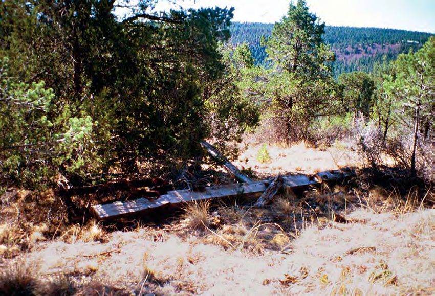
standing features remain (Fig. 8). The site measures 64 A prehistoric black chert point with serrated edges
m north-south by 62 m east-west. Boards and beams of was encountered on a small deer trail on Moon
milled lumber are mostly what remain, in the following Mountain on private land. Its size and shape suggest that
nominal dimensions (inches): 1 by 8, 2 by 6, 2 by 10, 2 it may have been an Archaic projectile point (Fig. 11). It
by 12, 2 by 14, 4 by 6, 4 by 8, 8 by 8, and 10 by 10 (Fig. was not collected.
9). One concentration of boards and heavy cable may
have once housed the machinery for the tram line (Fig. Biface Fragment
10). Three cement footings ranging from 2.5 ft square to
4 by 3 ft and 8-12 inches high are displaced from their The mid-section of a prehistoric white quartzite
original position. A small pit, measuring 23.6 by 29.4 by biface with serrated edges was also recorded on Moon
17 inches deep, may have once held a large wooden post Mountain. Although, its size suggest it may be Archaic,
for the tram. Another square post (12 by 12 inches) may its cultural affiliation is indeterminable. It was not col-
also have been a support post. Scattered among the lected.
17Figure 8. Plan of LA 135599.
SUMMARY hunting activities. Major prehistoric sites are north and
east of the project areas in lower-elevation drainages
In the heavily forested region around and within and waterways such as the Rio Bonito and Rio Hondo.
Ruidoso, sites of any time period are few. Almost all are Use of the dense forest on Moon Mountain for hunting
characterized by small, short-term occupations or uses by these larger population centers would certainly be
of the region. Other than the historic tramway (LA expected. Wild game in the area is plentiful at present,
135599), the isolated lithic projectile point and biface even with the encroachment of modern man, and may
fragment indicate prehistoric utilization of the area for have been even richer in prehistoric times.
18Figure 9. One of the large boards strewn across site. Facing southeast.
Figure 10. Housing for machinery may have stood here. Facing north.
19RECOMMENDATIONS recorded, photographed, and site records forms com-
pleted for the Laboratory of Anthropology. The tramway
has been dismantled and no standing structures or out-
lines of structures remain. The site may be considered to
lack integrity and because it is a surface manifestation,
does not have the potential to yield any further informa-
tion. It is, therefore, considered ineligible for the
National Register of Historic Places. However, LA
135599 may easily be avoided by tree-thinning crews as
it sits in a clearing with few trees. Red flagging tape has
been placed around the perimeter of the site so that it
may be avoided.
Figure 11. Projectile point with serrated edges.
ISOLATED OCCURRENCES
The survey of 267.5 acres of forested land on Moon
Mountain yielded one new site and two isolated occur- The two isolated occurrences of prehistoric lithic
rences of artifacts. The following recommendations artifacts have been documented, analyzed in the field,
refer to eligibility of the findings for the National and photographed. They have no potential for addition-
Register of Historic Places. al information important to the prehistory of the region.
We therefore recommend that no further action be taken
LA 135599 regarding these IOs during the implementation of the
tree-thinning project.
The site contains the remains of a modern tramway
built in the early 1950s on Moon Mountain. It has been
21REFERENCES CITED Altitudes in the Sacramento Mountains of South-
Central New Mexico. In High Altitude
Adams, Christopher D., Diane E. White, and David M. Adaptations in the Southwest, edited by J. C.
Johnson Winter, pp.159-167. Cultural Resources
2000 Last Chance Canyon: 1869 Apache/Cavalry Management Report No. 2. USDA Forest
Battle Site. USDA, Lincoln National Forest, Service, Southwestern Region.
Alamogordo.
Brown, David E.
Akins, Nancy J. 1994 Biotic Communities: Southwestern United States
1997 Archaeological Test Excavations along U.S. 70 and Northwestern Mexico. University of Utah
and a Data Recovery Plan for LA 110339, Press, Salt Lake City.
Mescalero-Apache Tribal Lands, Otero County,
New Mexico. Archaeology Notes 221. Office of Campbell, Kirsten J., and David H. Greenwald
Archaeological Studies, Museum of New 2001 Grindstone Lake Wildland Urban Interface:
Mexico, Santa Fe. Cultural Resource Survey, Smokey Bear Ranger
District, Lincoln National Forest, Lincoln
Alldritt, Phil County, New Mexico. Four Corners Research,
2000 Environment Setting. In The Angus Site: A Late Tularosa.
Prehistoric Settlement along the Rio Bonito,
Lincoln County, New Mexico, edited by D. Case, Charles P.
Zamora and Y. Oakes, pp. 3-6. Archaeology 1994 Rocky Mountain (Petran) and Maderean
Notes 276. Office of Archaeological Studies, Montaine Conifer Forest. In Biotic
Museum of New Mexico, Santa Fe. Communities: Southwestern United States and
Northwestern Mexico, edited by D. E. Brown,
Applegarth, Susan M. pp. 49-51. University of Utah Press, Salt lake
1976 Prehistoric Utilization of the Environment of the City.
Eastern Slopes of the Guadalupe Mountains,
Southeastern New Mexico. Ph.D. dissertation, Cosgrove, C. B.
University of Wisconsin, Madison. 1947 Caves of the Upper Gila and Hueco Areas in
New Mexico and Texas. Papers of the Peabody
Beckett, Patrick H. Museum of American Archaeology and
1973 Cochise Culture Sites in South Central and North Ethnology. Harvard University, Cambridge.
Central New Mexico. Master's thesis,
Department of Anthropology, Eastern New Driver, Jonathan C.
Mexico University, Portales. 1990 Bison Assemblages from the Sierra Blanca
Region, Southeastern New Mexico. Kiva
Beidl, Jacqueline 55(3):245-263.
1990 Analyses of Artifacts from Three Potential
Apache Sites in the Mountains of South Central Dunham, Roxanne K.
New Mexico. Master's thesis, Department of 1980 An Archaeological Reconnaissance of the
Anthropology, New Mexico State University, Proposed Sierra Blanca Airport, Lincoln County,
Las Cruces. New Mexico. Cultural Resources Management
Division Report No. 348. New Mexico State
Broster, John B. University, Las Cruces.
1980 Projectile Point Analysis. In A Cultural Resource
Management Plan for Timber Sale and Forest Eidenbach, Peter L.
Development Areas of the Mescalero Apache 1983 Summary and Conclusion. In The Prehistory of
Indian Reservation, vol. 1, edited by B. Harrill, Rhodes Canyon, New Mexico. Human Systems
pp. 93-103. Bureau of Indian Affairs, Research, Tularosa.
Albuquerque.
Farwell, Robin E., Yvonne R. Oakes, and Regge
Broster, John B., and Bruce G. Harrill Wiseman
1983 Investigations of Prehistoric Remains at High- 1992 Investigations into the Prehistory and History of
the Upper Rio Bonito, Lincoln County,
23Southeastern New Mexico. Laboratory of 1991 An Overview of the Capitan North Project. In
Anthropology Notes 297. Museum of New Mogollon V, edited by P. H. Beckett, pp.166-176.
Mexico, Santa Fe. COAS Publishing and Research, Las Cruces.
Fenneman, Nevin M. Kilby, J. David, and Elizabeth A. McNally
1931 The Physiographic Provinces of the Western 1994 Feather Cave Archaeological Complex: Cultural
United States. McGraw-Hill, New York. Resource Management Plan. Eastern New
Mexico State University, Portales.
Hard, Robert J., and D. Nickels
1994 The 1993 University of Texas at San Antonio Lehmer, Donald J.
Excavations at LA 89652: The Tortolita Canyon 1948 The Jornada Branch of the Mogollon. Social
Site. Center for Archaeological Research, Science Bulletin 17. University of Arizona,
University of Texas, San Antonio. Tucson.
Higgins, Howard C. Mera, H. P.
1984 A Cultural Resource Inventory of Site "B" for the 1940 An Approach to the Identity of the Jumano
Proposed Sierra Blanca Airport, Lincoln County, Pueblos in the Saline-Medano District through
New Mexico. Office of Contract Archeology, Archaeological Evidence. In Some Aspects of the
University of New Mexico, Albuquerque. Jumano Problem, edited by F. V. Scholes and H.
P. Mera, pp. 291-299. Carnegie Institution
Hohmann, John W. Publication 523. Washington, D.C.
1995 A Phase I (Class III) Archaeological Survey of
5.5 Miles along U.S. 70, Lincoln and Otero Mueller, Jerry E.
Counties, New Mexico. Cultural Resource Group 1991 Climate of Cloudcroft-Ruidoso Country. In
Report No. 45. Louis Berger & Associates, Geology of the Sierra Blanca, Sacramento and
Albuquerque. Capitan Ranges, New Mexico, edited by J. M.
Barker, B. S. Kues, G. S. Austin, and S. G. Lucas,
Human Systems Research pp.2-3. New Mexico Geological Society,
1973 Survey of the Tularosa Basin. Tularosa. Socorro.
Katzenberg, M. Anne, and Jane H. Kelley Nehrer, Raymond E.
1991 Stable Isotope Analysis of Prehistoric Bone from 1976 Soil Survey of Mescalero-Apache Area, New
the Sierra Blanca Region of New Mexico. In Mexico, Northeastern Otero County. U.S. Soil
Mogollon V, edited by P. H. Beckett, pp. 207- Conservation Service and Bureau of Indian
219. COAS Publishing and Research, Las Affairs.
Cruces.
Noyes, Peter
Keesling, Henry S. 1988 Historic and Prehistoric Land Use of Fort
1980 Past Climate. In A Cultural Resource Stanton Mesa: The Sierra Blanca Airport
Management Plan for Timber Sale and Forest Archaeological Project (Draft Final). University
Development Areas on the Mescalero Apache of New Mexico, Office of Contract Archeology,
Indian Reservation, edited by B.G. Harrill, pp. Albuquerque.
44-46. Bureau of Indian Affairs, Albuquerque
Area Office, Albuquerque. Oakes, Yvonne R.
2000 Cultural Associations in the Sierra Blanca
Kelley, Jane Holden Region. In The Angus Site: A Late Prehistoric
1966 The Archaeology of the Sierra Blanca Region of Settlement along the Rio Bonito, Lincoln County,
Southeastern New Mexico. Ph.D. dissertation, New Mexico, edited by D. Zamora and Y. Oakes,
Harvard University, Cambridge. pp. 7-30. Archaeology Notes 276. Office of
Archaeological Studies, Museum of New
1984 The Archaeology of the Sierra Blanca Region of Mexico, Santa Fe.
Southeastern New Mexico. Museum of
Anthropology Anthropological Papers 74. 2001 Archaeological Survey for Ruidoso Fuels
University of Michigan, Ann Arbor. Reduction and Utility Line Clearing Projects,
24Lincoln County, New Mexico. Archaeology Bannister
Notes 298. Office of Archaeological Studies, 1953 A Foundation for the Dating of Some Late
Museum of New Mexico, Santa Fe. Archaeological Sites in the Rio Grande Area,
New Mexico, Based on Studies in Tree Ring
in prep. Methods and Pottery Analysis. Laboratory of
Excavations at Mescalero Rockshelter. Office of Tree-Ring Research Bulletin 6. Tucson.
Archaeological Studies, Museum of New
Mexico, Santa Fe. Speth, John D., and Susan L. Scott
1985 Late Prehistoric Subsistence Change in
Opler, Morris E., and C. Opler Southeastern New Mexico: The Faunal Evidence
1950 Mescalero Apache History in the Southwest. from the Sacramentos. In Proceedings of the
New Mexico Historical Review 25(1):1-36. Third Jornada Conference, edited by M. S.
Foster and T. C. O'Laughlin. El Paso
Prince, Patricia A. Archaeological Society 23(1-2):140-148.
1980 Mescalero Apache: An Ethnographic Summary.
In A Cultural Reosurce Management Plan for Spoerl, Patricia M.
Timber Sale and Forest Development Areas on 1983 Thousands of Years of Use: Prehistory and
the Mescalero Apache Indian Reservation, edit- History on the Lincoln National Forest. USDA
ed by B.G. Harrill, pp. 79-83. Bureau of Indian Forest Service, Southwestern Regional Office,
Affairs, Albuquerque Area Office, Albuquerque. Albuquerque.
Ravesloot, John C., and Patricia M. Spoerl 1985 Mogollon Utilization of the Sacramento
1984 The Jicarilla Mountains: Pre-Lincoln Phase Mountains of Southcentral New Mexico. In
Settlement in the Northern Jornada Mogollon Views of the Jornada Mogollon, edited by C. M.
Periphery. In Recent Research in Mogollon Beck, pp. 33-40. Contributions in Anthropology
Archaeology, edited by S. Upham, F. Plog, D. G. 12. Eastern New Mexico University, Portales.
Batcho, and B. F. Kaufman, pp. 179-192.
University Museum, New Mexico State Sprankle, Dale G.
University, Las Cruces. 1983 Soil Survey of Lincoln County Area, New
Mexico. Soil Conservation Service and USDA.
Rocek, Thomas R.
1995 Sedentarization and Agricultural Dependence: Stewart, Joe D., Jonathan C. Driver, and Jane H. Kelley
Perspectives from the Pithouse-to-Pueblo 1991 The Capitan North Project: Chronology. In
Transition in the American Southwest. American Mogollon V, edited by P. H. Beckett, pp. 177-
Antiquity 60(2):218-239. 190. COAS Publishing and Research, Las
Cruces.
Schroeder, Albert H.
1973 The Mescalero Apaches. In Technical Manual: Stuart, David E., and Rory P. Gauthier
1973 Survey of the Tularosa Basin: The Research 1981 Prehistoric New Mexico: Background for
Design, pp. 124-144. Human Systems Research, Survey. Historic Preservation Division, Office of
Albuquerque. Cultural Affairs, State of New Mexico, Santa Fe.
Sebastian, Lynne, and Signa Larralde Tainter, Joseph A.
1989 Living on the Land: 11,000 Years of Human 1985 Perspectives of the Abandonment of the
Adaptation in Southeastern New Mexico. Bureau Northern Tularosa Basin. In Views of the
of Land Management Cultural Resources Series Jornada Mogollon, edited by C. M. Beck, pp.
No. 6. 143-147. Contributions in Anthropology 12.
Eastern New Mexico University, Portales.
Shelley, Phillip H.
1991 Progress Report on Rio Bonito/Fort Stanton Thomas, Alfred Barnaby
Archaeological Research Project, Summer 1988. 1974 The Mescalero Apache, 1653-1874. In Apache
Eastern New Mexico University, Portales. Indians, vol. 11, edited by D. A. Horr. Garland
Publishing, New York.
Smiley, Terah L., Stanley A. Stubbs, and Bryant
25You can also read