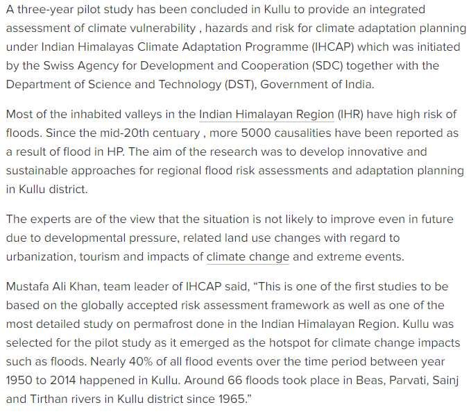
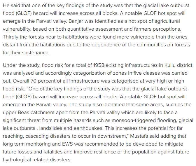
National Media Consultation and Kullu Field Visit in Print - CMSINDIA
←
→
Page content transcription
If your browser does not render page correctly, please read the page content below
National Media Consultation and Kullu Field Visit in Print

                                   IHCAP-CMS
           National Media Consultation on Climate Change Reporting
                            at New Delhi & Kullu
                                     from
                           September 21-24, 2019
          Research House, Saket Community Centre, New Delhi, India- 110017
              Phone: +91-11-2685 1660; 26864020 Fax: +91-11-2696 828
              Email: info@cmsindia.org    Website: www.cmsindia.org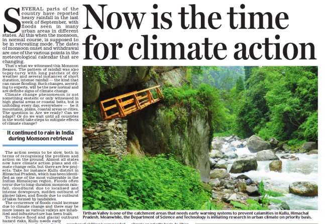

Climate vulnerability map of India coming soon
Authored By : Dinesh C Sharma

India Science Wire Posted By : priyad

Posted Date : Sat, 2019-09-28 16:27

Link: https://www.indiawaterportal.org/articles/climate-vulnerability-map-india-coming-soon

DST and SDC working together to develop pan-India climate vulnerability assessment map, to help
communities and states better prepare for climate change.

                                                                                     Dr. Akhilesh Gu
          pta , head of the climate change programme at DST. Image source: India Science Wire
New Delhi, September 27 (India Science Wire): Rising sea levels, increasing number of extreme
weather events, urban floods, changing temperature and rainfall patterns - such impacts of climate change
are being felt in many parts of India, and not just in the coastal areas or hilly regions.

To prepare communities and people to meet the challenge arising out of such changes, information specific
to a state or even district is needed because such impacts of climate change are not uniform. In order to
meet this need, a pan India climate vulnerability assessment map is being developed.

The map is being developed under a joint project of the Department of Science and Technology and the
Swiss Agency for Development and Cooperation (SDC).

"Such a climate vulnerability atlas has already been developed for 12 states in the Indian Himalayan
Region, using a common framework. Now this methodology will be extended to non-Himalayan states so
that we can have a national level climate vulnerability profile for India. The atlas is expected to be ready
by the middle of 2020," announced Dr. Akhilesh Gupta, head of the climate change programme at DST
while speaking at a national media consultation on climate change in New Delhi.
Dr. Gupta said using a common methodology for assessing vulnerability was critical for comparison and
for planning adaptation strategies. It also helps in identifying what makes a state or district vulnerable to
climate change.

The vulnerability map for hilly states, released in March this year, showed that while all the Himalayan
states are vulnerable, Assam and Mizoram are the most vulnerable among them. The map for the
Himalayan region, developed in consultation with states, has details up to the district level. The national
map will also do the same, as vulnerability within a state may differ from one region or district to another.
A common set of indicators will be used vulnerability profile and ranking of 650 districts all over the
country.

Dr. Gupta said the climate change research programme of DST was being implemented as part of the
National Mission for Sustaining the Himalayan Ecosystem (NMSHE) and National Mission on Strategic
Knowledge for Climate Change (NMSKCC). Among the priority areas identified for research are
glaciology, climate modeling, urban climate, extreme events and Himalayan ecosystem studies. In all,
there are climate change cells in 25 states in the country, with centres of excellence also being established
at the state level for capacity building.

Climate risk is the interplay of hazard, exposure and vulnerability. While the occurrence of natural hazards
such as landslides, droughts and floods is projected to go up, their impact depends on the level of exposure
to people and infrastructure in areas that could be adversely affected, or to places where people's
livelihoods are sensitive to changing climates.

"Vulnerability is the propensity to be adversely affected and can be measured in terms of both biophysical
as well as socioeconomic factors. Addressing vulnerability can help reduce risk to climate change,"
explained Dr. Anamika Barua of IIT Guwahati, who led the vulnerability assessment project for the
Himalayan region.

Among the socio-economic and demographic factors that determine vulnerability are population density;
percentage marginal farmers; livestock to human ratio; per capita income; number of primary healthcare
centres; and percentage of women in the overall workforce. Similarly, sensitivity of agricultural production
is captured by indicators like percentage area under irrigation; yield variability; and percentage area under
horticulture crops.

Dr. Mustafa Ali Khan (Indian Himalayas Climate Adaptation Programme) said some states had already
started using the vulnerability assessment report, particularly while revising state climate action plans and
developing adaptation projects. Mizoram has launched a state wide public awareness campaign on the
basis of the assessment, while West Bengal has developed a decision support system for prioritizing
springshed management project sites using the climate vulnerability map as an input.

The consultation was organised by DST, IHCAP and Centre for Media Studies (CMS).

(India Science Wire)
Govt to launch climate vulnerability map of
India soon
A common set of indicators will be used for vulnerability-profiling and ranking of
650 districts all over the country

Link: https://www.downtoearth.org.in/news/climate-change/govt-to-launch-climate-
vulnerability-map-of-india-soon-66985

By Dinesh C Sharma
Last Updated: Saturday 28 September 2019

   Photo: Rejimon Kuttappan

Rising sea levels, increasing number of extreme weather events, urban floods,
changing temperature and rainfall patterns are the impacts of climate change being
felt in many parts of the country and not just coastal areas or hilly regions. For
preparing communities and people to meet the challenge arising out of such
changes, information specific to a state or even district is needed because such
impacts of climate change are not uniform. In order to meet this need, a pan India
climate vulnerability assessment map is being developed.

The map is being developed under a joint project of the Department of Science and
Technology (DST) under the Union Ministry of Science and Technology and
Swiss Agency for Development and Cooperation (SDC).
“Such climate vulnerability atlas has already been developed for 12 states in the
Indian Himalayan Region, using a common framework,” said Akhilesh Gupta,
head of the climate change programme at DST, while speaking at a national media
consultation on climate change in New Delhi on September 27, 2019.

“Now this methodology will be extended to non-Himalayan states so that we can
have a national level climate vulnerability profile for India. The atlas is expected to
be ready by the middle of 2020,” Gupta announced. Gupta said using a common
methodology for assessing vulnerability was critical for comparison and for
planning adaptation strategies. It also helps in identifying what makes a state or
district vulnerable to climate change.

The vulnerability map for hilly states, released in March this year, showed that
while all the Himalayan states are vulnerable, Assam and Mizoram are the most
vulnerable among them.

The map for the Himalayan region, developed in consultation with states, has
details up to the district level. The national map will also do the same, as
vulnerability within a state may differ from one region or district to another.

A common set of indicators will be used vulnerability profile and ranking of 650
districts all over the country.

Gupta noted the climate change research programme of DST was being
implemented as part of the National Mission for Sustaining the Himalayan
Ecosystem (NMSHE) and National Mission on Strategic Knowledge for Climate
Change (NMSKCC).

Among the priority areas identified for research are glaciology, climate modeling,
urban climate, extreme events and Himalayan ecosystem studies. In all, climate
change cells have been in 25 states in the country and centres of excellence are also
being established in states for capacity building.

Climate risk is interplay of hazard, exposure and vulnerability. While the
occurrence of natural hazards such as landslides, droughts and floods is projected
to go up, their impact depends on the level of exposure such as presence of people
and infrastructure in areas that could be adversely affected or climate-sensitive
livelihood of people.

“Vulnerability is the propensity to be adversely affected and can be measured in
terms of both biophysical as well as socio-economic factors. Addressing
vulnerability can help reduce risk to climate change,” explained Anamika Barua of
Indian Institutes of Technology Guwahati, who led the vulnerability assessment
project for the Himalayan region.

Among the socio-economic and demographic factors that determine vulnerability
are population density; percentage marginal farmers; livestock to human ratio; per
capita income; number of primary healthcare centres; and percentage of women in
the overall workforce. Similarly, sensitivity of agricultural production is captured
by indicators like percentage area under irrigation; yield variability; and percentage
area under horticulture crops.

According to Mustafa Ali Khan from Indian Himalayas Climate Adaptation
Programme, some states had already started using the vulnerability assessment
report, particularly while revising state climate action plans and developing
adaptation projects. Mizoram has launched a state wide public awareness campaign
on the basis of the assessment, while West Bengal has developed a decision
support system for prioritizing springshed management project sites using the
climate vulnerability map as an input. (India Science Wire)
Poly-houses help India’s farmers survive erratic weather
Link: https://www.thethirdpole.net/en/2014/10/07/poly-houses-help-indias-farmers-survive-erratic-
weather/

Small and marginal farmers in India’s Himachal Pradesh state are supplementing their income from
vegetable production thanks to poly-houses that regulate temperature and other climatic conditions

(Photo by Greenpeace)

Nivedita Khandekar, October 7, 2014

Hilly terrain and increasingly uncertain climatic conditions have restricted agricultural development
in India’s hill state of Himachal Pradesh. But increased demand for vegetables due to rapid
urbanisation and growing tourism have come as boon for the state, which is now pushing poly-
houses (also known as polytunnels) to help farmers, particularly small and marginal ones, tide over
climate changes with an assured vegetable crop, even off-season.

A poly-house works on the concept of a greenhouse that lets in light and traps heat inside. But
instead of glass, it is made from polythene sheets or flexible plastic sheets.

Marginal and small farmers are the group most affected by the vagaries of nature. But the use of
poly-houses for growing vegetables – promoted by the state government by offering subsidies – has
increased their yield in a given cycle and also helped them harvest vegetables in three cycles each
year. These small land holdings are mostly located on hill slopes near where the farmers live.
According to state government records, small and marginal farmers (with up to two hectares of land)
comprise 87% of total land holdings. Medium farmers (with 2-10 hectares of land) form about 13%
and large land holding farmers are only about 0.4%.

A poly-house – built as part of the state government’s ‘precision farming practices’ project – helps
the farmers protect crops or vegetables from sudden hailstorms or excessive rains and erratic
temperature changes. Even in harsh winters, poly-houses help farmers earn from off-season
cultivation. The state has received assistance from National Bank of Agriculture and Rural
Development (NABARD) for this scheme.

Jagdish Chandra, a farmer from Kandbari village near the town of Palampur, is one of those who has
benefited from poly-houses. Chandra, who owns about four hectares of land, installed two poly-
houses (one 105 square metres and another 250 square metres) in 2009 when the subsidy was
offered for the first time. Five years later, he is happy to have shifted to the modern technique which
has increased his yield by more than 70%.

“Depending on natural rain, I used to get two crops but the second was not always assured. Now I
get three crop cycles in a year,” Chandra said, showing the vegetables inside his poly-house right
next to his home.

He grows capsicum, tomato, bitter gourd, radish, beans and coriander using drip irrigation. The
process is completely organic. “We need to keep check on the temperature inside the poly-house. If
it is too warm inside, then we have the sprinkler to cool down the temperature. At other times,
when it is cooler outside and warmer inside, all we do is simply open the door,” he added.

His small village has four more farmers using poly-houses to grow vegetables.

The state-government run Precision Farming Development Centre (PFDC) at Solan helps by designing
poly-houses and offering training to farmers. It also provides farmers with technical assistance
during the actual crop cycle. When the government offered subsidies for poly-houses for the first
time in 2009, the centre trained only about eight-10 farmers per year. In 2013, this number
increased to more than 50 farmers per year.

Saving water

“Poly-houses help reduce evaporation. Farmers can thus use sprinkler and/or drip irrigation and save
water,” said R.S. Spehia, assistant professor at PFDC.

Scientist H.R. Sharma has dispelled fears poly-houses use excessive water – as has been the case
with rose cultivation using poly-houses especially in plains.
“We are talking about poly-houses in the hills. Here temperatures are lower (compared to plains)
and hence evaporation is less. Moreover, we promote poly-houses with drip irrigation, which further
lessens the water use,” Sharma, who is principal scientist at the Regional Horticulture Research and
Training Station at Mashobra in Shimla, said.

The state government provides as much as 80% of the costs while the farmer needs to pitch in the
remaining 20%. The subsidy includes a water harvesting system with the poly-house, explained a
government official.

“Productivity…especially for ‘poly-house suitable crops’ such as capsicum, tomato, peas, beans,
cucurbits etc. have shown significant increase,” Spehia said.

For example, production of tomatoes increased by 15% comparing 2007-09 and 2010-12. The
production of beans and cucurbits increased by 13% during the same period.

By December 2013, 13,500 poly-houses had been constructed. An area of 147 hectares had been
covered under protective cultivation. This far exceeds state government targets. In February 2013,
chief minister Virbhadra Singh had said during his budget speech: “I propose Rs 100 crore (about
US$16 million) to popularise farming inside poly-houses to augment farmers’ incomes. The target is
set for constructing 4,700 poly-houses.”

“We have been recommending naturally ventilated poly-houses of bamboo, locally available, which
can be used with certain modifications to cut the initial investment,” Spehia said.
Link: https://www.dailypioneer.com/2019/pioneer-exclusive/digital-bid-to-save-3m-himalayan-
springs.html
पार्वती र्ैली और बंजार में जलर्ायु पररर्तवन पर दो ददर्सीय कायवशाला
Shimla News - जलर्ायु पररर्तवन को लेकर कुल्लू घाटी में दो ददर्सीय कायवशाला का आयोजन दकया गया।
जजसमें दे श भर के वर्भभन्न राज्यों...
Bhaskar News NetworkSep 26, 2019, 07:20 AM IST
Aani News - two day workshop on climate change in parvati valley and banjar
जलर्ायु पररर्तवन को लेकर कुल्लू घाटी में दो ददर्सीय कायवशाला का आयोजन दकया गया। जजसमें दे श भर के
वर्भभन्न राज्यों से आए करीब 45 पत्रकारों ने भाग भलया।
इस कायवशाला में फील्ड वर्जजट के दौरान पार्वती र्ैली के शाट, धाभमवक र् पयवटक नगरी मजिकिव के अलार्ा
बंजार का फील्ड वर्जजट दकया गया। कायवशाला का उद्दे श्य जलर्ायु पररर्तवन अनुकूल पर पत्रकारों को वर्शेषज्ञों
और क्षेत्र की यात्रा द्वारा इं टरे जटटर् प्रस्तुभतयों के साथ उन्मुख करना था।
आयोजन में दे शभर के वर्भभन्न राज्य से आए हुए पत्रकार, पयावर्रि वर्भाग के वर्शेषज्ञ र् सेंटर फॉर मीदडया
स्टडी की टीम सदहत आपदा सेेे प्रभावर्त लोगों के साथ दकसान-बागर्ान भी उपजस्थत रहे । कायवशाला का मुख्य
उद्दे श्य पयावर्रि पररर्तवन से हो रही आपदाओं के बचार् र् कृ वष में आए भारी बदलार् के बारे में जनता को
जागरूक करना है ।
वर्शेषज्ञों द्वारा बताई गई पयावर्रि पररर्तवन पर महत्र्पूिव जानकारी को मीदडया के माध्यम से जनता तक
पहुंचाने र् उन्हें जागरूक करने केेेेे
े े भलए वर्ज्ञान र् प्रौद्योभगकी मंत्रालय भारत सरकार द्वारा इस तरह के
कायवक्रम दकए जाते हैं । कुल्लू घाटी में भी इसके भलए फील्ड वर्जजट दकया गया। जजसमें सीएमएस की भनदे शक
अनु आनंद, पयावर्रि वर्भाग के दन
ू ी चंद ठाकुर दडप्टी कोऑदडव नेटर टलाइमेट सैल दहमाचल प्रदे श र् दे शभर से
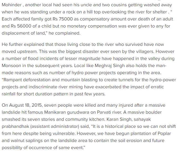
आए हुए पत्रकारों के साथ जजला कुल्लू के पत्रकारों ने भी भाग भलयाFlash-flood prone Kullu's Parvati valley in Himachal Pradesh awaits alert warning system Kullu's Parvati Valley identified as risk hot spot Monday, 30 September 2019 | Archana Jyoti | Kullu Link: https://www.dailypioneer.com/2019/india/flash-flood-prone-kullu-s-parvati-valley-in- himachal-pradesh-awaits-alert-warning-system.html The writing is on the wall: Kullu's Parvati Valley, a tourist destination in Himchal Pradesh, has been identified as a major risk hotspot for monsoon flood, landslides, cloudburst mishaps and potential glacial lake outburst floods (GLOFs) in the Indian Himalayan Region (IHR). But the Centre continues to look the other way as a Rs 20 crore proposal for early warning system with last mile connectivity to community is gathering dust with Union Environment Ministry since 2015. The installation of the EWS as a preparedness measure is one of the main recommendations of the IHCAP (Indian Himalayas Climate Adoptation Programme) of the Swiss Development Agency for Development and Cooperation. The EWS has to implemented in cooperation with the Central Government's Department of Science and Technology (DST) while the Union Environment Ministry has to fund the project. The recommendation followed a study conducted in the wake of the big cloud burst tragedy that struck in 1994 in the region where Parvati river, a tributary of Beas river flows. Atleast 27 died while several were left injured. The EWS aims at warning the population in in Parvati Valley and adjoining areas inhabited by around 1,600 villagers and frequented by tourists regularly. DC Thakur, a senior official from Department of Environment and Science & Technology, HP said: "The proposal is pending with the Union Environment Ministry since2015." He asserted that Parvati Valley in the IHR is at high risk of floods due to developmental pressures, changes in land holding pattern in terms of urbanisation and tourism besides impacts of climate change and extreme events. Considering the geographical position of the locality we cannot avoid disasters but intervention measures need to be taken to ensure minimum loss to life and property, he said. The locals too voiced their concern demanding timely intervention measures. "Even though cloud bursts with such severity have not occured in the last 25 years, there is no guarantee that it would not happen in the future," apprehended inhabitants of Shaat and Ladari villages of the Valley. In fact, they said matter-of-factly that the 1994 cloudbursts provided a demonstration of what could be expected in the future and the need for preparedness to deal with such a situation.
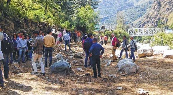
The memory of the devastation refuses to go away. Kamal Chand, ex-sarpanch of Ladari village
recalled, "It was all over in a few minutes. The water level in the river rose 40 to 50 feet high on that
fateful day."

Many lives would have been saved had the people been alerted about the disaster that day, he told
a group of journalists during a field visit to the valley as part of a media workshop organised by the
Centre for Media Studies (CMS), an advocacy group under the IHCAP recently.

Shaat village resident, Mohinder Singh and Hemraj, both survivors, minced no words as they said
that the Government had not done much to improve resilience of the locals against future
hydrological-disasters, if any.

According to the IHCAP assessment, the GLOF will increase across all blocks of Kullu, with Parvati
Valley emerging as the most vulnerable one. According to it, atleast 66 floods have taken place since
1965.The flood assessment for Kullu district indicates variation in hazard levels for different
catchment areas.

"The occurance of floods is not expected to decrease and its consequences could become even
worse in view of the ongoing climate changes and increasing demographic pressure," as per the
study.

It has stressed on capacity building and specialised training of communities on appropriate response
mechanism, including identification of shelters and evacuation path.

Annu Anand, Director (Advocacy) from the CMS pointed out that it was important that issues of
climate change whose impacts are being felt across the Indian Himalayas affecting the livelihood,
water availability and biodiversity in the region, needs to be highlighted. "Hence, sensitization and
training to media is necessary to take the right messages about climate change to people as well as
policy makers and motivate them to take action at all the requisite levels," she added
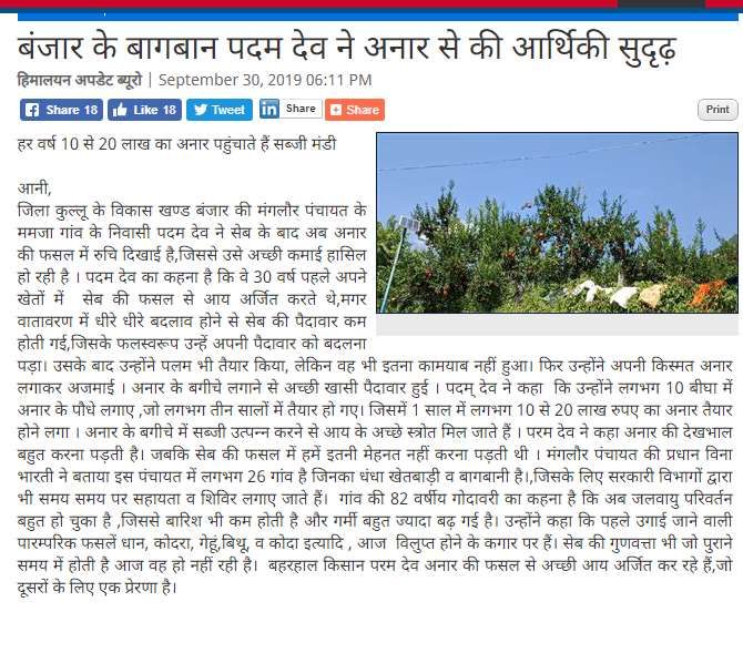
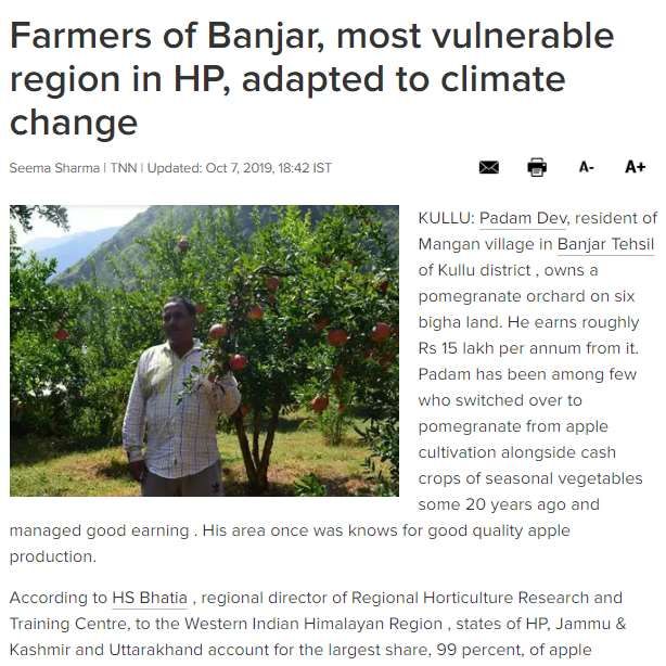
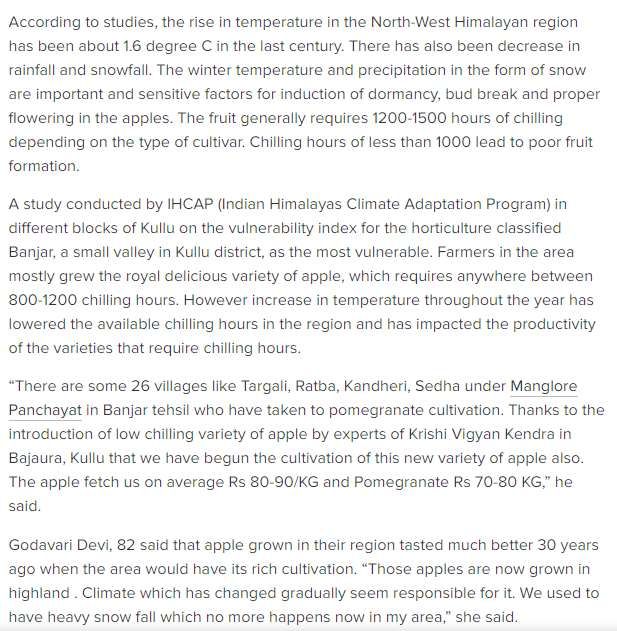
Climate change compels Himachal farmers to forsake apple farming

Padam farmer of Banjar with pomegranate

Link: http://www.ifp.co.in/page/items/61707/climate-change-compels-himachal-farmers-to-
forsake-apple-farming

By Babie Shirin

IMPHAL | Sep 26

Due to climate change, farmers of Banjar town in Kullu district of Himachal Pradesh
have shifted their traditional cultivation of apple to pomegranates. The town has been
identified as an agricultural vulnerability hot spot, based on quantitative assessment and
farmers’ perception as per the Indian Himalayas Climate Adaptation Programme
(IHCAP).

Three years ago, when production of apples decreased, farmers of Banjar shifted to
other fruits like plums etc, but due to rising temperatures they further shifted to
pomegranate cultivation, said farmer, Padam while interacting with this IFP reporter
during a field visit to the valley as a part of media workshop organised by Centre for
Media Studies under the IHCAP.
The farmers further expressed that overall apple production in the Himalayan region
decreased between the year1982 and 2005. This is due to increase in temperature
which has further caused a reduction of total chilling hours in the region, they said.

It is said that a decline of more than 9.1 units per year has occurred in the last 23 years.
With increasing temperature, the area for production may have to be shifted to higher
altitudes. Earlier, apple could be grown at 3500 feet, now it has gone up to 5000 feet, as
per sources.
Climate cell officer, Thakur expressed that research is going on to identify the variety of
fruits or apples that could be produced at lower altitudes. A study was conducted by
IHCAP in different blocks of Kullu district, and Banjar town was identified as the most
vulnerable valley. It highlighted the need for having a holistic approach in understanding
climate risks and vulnerabilities for adaptation of planning and implementation.

Farmers of Banjar expressed that increase in temperature and decrease in winter rainfall
and snowfall has reduced the number of chilling hours, leading to a decline in apple
production in the region.
No early warning system yet for Kullu’s Parvati valley even 25 yrs
after big cloud burst tragedy
Link: https://www.indianewsstream.com/no-early-warning-system-yet-for-kullus-parvati-
valley-even-25-yrs-after-big-cloud-burst-tragedy/

The place in Shaat village of Parvati valley where water rose to 30 to 40 feet during the
August 11, 1994 cloud burst .

By Naz Asghar

Sep 25, 2019

Kullu (Himachal Pradesh): Even Twenty five years after the cloud burst disaster that
struck Parvati valley in this district of Himachal Pradesh, the people of the area are yet to
get an early warning system(EWS).

The devastation caused by August 11, 1994 flash floods is still fresh in the minds of the
survivors of the tragedy in Shaat and Ladari villages of the valley.

”It was all over in five minutes. Rather it is just matter of a minute in such events.The
water level in the river rose to 40 to 50 feet high that fateful day, ” says former sarpanch
of ladari village Kamal Chand while recalling the terrifying flash flood resulting from a
cloudburst high up in the mountains that reduced the whole villages to rubble, claiming
27 lives.

Many lives would have been saved if the people would have been alerted about the
coming disaster that day.

Establishment of an EWS with last mile linkage to community is one of the main
recommendation of the IHCAP(Indian Himalyas Climate Adoptation Programme) of the
Swiss Development Agency for Development and Cooperation being implemented in
cooperation with the Department of Sceince and Technology of the Indian Government.
”The proposal for Rs 20 crore project to set up the system has been sent to the Ministry
of Environment, Forest and Climate Change way back in 2015, but it is yet to get its
approval,” Himachal Pradesh Government’s climate cell officer DS Thakur told a group
of journalists during a field visit to the valley as part of a media workshop organised by
the Centre for Media Studies under the IHCAP this week.

Mohinder Singh of Shaat village, who was 16 years old in 1994 when the flashfloods hit
his village, had a feeling that not much was done by the government after the tragedy
that could match the enormity of the risk people of the area were exposed to.” That day,
the stormy gales of winds with high whistle-like sound that preceded the flashfloods were
so powerful that trees and houses were blown away even before water could pound
them. Words fail me to describe the horror,” he says recalling the nature’s fury which
claimed the life of his two uncles and one sister.

”Though the compensation was given for the dead but no compensation was given for
our land that degraded due to the flash floods,” he said. Another survivor of the disaster
Hemraj was also on the spot, but he was nine months old then. His parents perished in
the falshfloods and he was brought up by his grandfather.

Three of the survivors of 1994 cloud burst in Parvati valley: (From left) Mohinder Singh,
Hemraj and Kamal Chand.

As per IHCAP recommendation, the most urgent adaptation action that needs to be
taken is to prepare the government agencies to alert and rescue people. This
programme, in the context of Kullu, could be linked to Himachal Pradesh Disaster
Management Authority. It also lays stress on capacity buliding and specialised training of
communities on appropriate response mechanism, including the identification of shelters
and evacuation path. Kullu being a hot spot for climate chang impacts such as flood, a
flood risk assessment of Parvati valley has been done in collaboration with IHCAP and
proposals submitted to the Ministry of Environment and Forests.

The Adaptation proposals also relate to climate-resilient agri-horticulture and eco-based
adoptation(Great Himalyan National Park).According to IHCAP assessment, the glacial
lake outburst floods(GLOF) will increase across all blocks of Kullu, with Parvati valley
emerging as the hot spot. Banjar was identified as a hot spot of agricultural vulnerability,
based on both quantitative assessment and farmers’ perceptions.

The journalists were also taken to Banjar valley, where farmers after facing damage of
their apple crop for several successive years due to rising temperatures because of
climate change, had to switch to cultivation of other fruits. Farmer Padam Singh said he
had to shift cultivation of pomegranates in place of apples due to the changes in the
climate .’

‘Thirty years ago when the apple crop did not yield good results, we shifted to plum, but
as temperature rose further, we have now taken to pomegranate cultivation. For apple,
you have to to a height of 5000 feet, while earlier apple could be grown at 3500 feet.” he
said.

Climate cell officer Thakur said research was now directed towards developing such
varieties that did not require that much height, and aim was to develop such varities as
reqired less space but yield more produce.

Also efficient use of water in irrigation was a big priority owning to depletion of water
resources as a result of climate change.

Eighty year old woman resident of the village Godavri told journalists that rain and snow
had both decreased in the valley during her life time. Supporting her observation, village
sarpanch Naina Devi said the impact on the flow of river was quite visible.” Nadian to
sookh hi gai hain( Rivers have almost dired up), she said.

Farmers in Banjar tehsil and other parts of Himachal Pradesh have also taken to
vegetable production in poly houses as climatic uncertainties threaten their livelihood. By
regulating temperature and other climatic conditions, polyhouses give them assured
crops and in three cycles in a year. The Himachal Pradesh Government is promoting
these poly houes which like a greenhouse, lets the light in but trap heat.Motilal Negi told
the visiting journalists that besides simulating appropriate climatic conditions, the
polyhouese were also saving their crop from pests.

Motilal Negi said that besides simulating appropriate climatic conditions, the polyhouese
were also saving their crop from pests.

India News Stream

Link: https://www.gaonconnection.com/read/assam-most-vulnerable-to-climate-change-in-
the-indian-himalayan-region-46381

Assam most vulnerable to climate change in the Indian
Himalayan Region
A recent scientific assessment of climate vulnerability in the Indian Himalayan
Region has ranked Assam as the most vulnerable state and Sikkim as least
vulnerable to climate change. Overall, the entire region is under severe threat due to
the changing climate

Nidhi Jamwal 3 Oct 2019

1,300 metres above mean sea level. Kullu, Himachal Pradesh. Padam Dev, a pomegranate
farmer in Mamjiya village of Kullu district in Himachal Pradesh, has grown up hearing
stories of his father and grandfather's apple orchards. He hasn't been able to grow even a
single apple fruit in his orchard in Banjar block, about 170 kilometres (km) from the state
capital Shimla. "Now there isn't enough winter chill and cold months to grow apple in my
village," he told Gaon Connection. Over 2,000 km away, at an elevation of 2,500 metres
above mean sea level, 92-year-old Til Bahadur Chhetri of Hee Patal village in West Sikkim is
worried about the declining yield of his black cardamom (Amomum subulatum) crop.

 "The rains have become erratic and temperatures are rising bringing in new pests," lamented
Chhetri. Another 600-km away, 54 per cent surveyed springs in Meghalaya have reported
reduced water discharge of up to 50 per cent, threatening the water security of the north-
eastern state. Both villagers and water sector experts blame it on the changing rainfall pattern
(coupled with some other factors). 92-year-old Til Bahadur Chhetri in West Sikkim is
worried about the declining yield of black cardamom.

The Indian Himalayan Region, covering over 16 per cent of the India's geographical area and
home to over 50 million people, is highly vulnerable to climate change impacts. To
understand the extent of vulnerability, for the first time a scientific assessment of climate
vulnerability of states in this region has been carried out using a common framework of
indicators. Titled 'Climate Vulnerability Assessment for the Indian Himalayan Region Using
a Common Framework', the assessment report maps and ranks all the 12 states in the region
(only the hill districts of Assam and West Bengal) based on how vulnerable they are to
climate change (see map: Vulnerability index and ranking of states in the Indian Himalayan
Region). Map: Vulnerability index and ranking of states in the Indian Himalayan Region
Source: Climate Vulnerability Assessment for the Indian Himalayan Region Using a
Common Framework 2018-19. Assam is ranked number one on the climate vulnerability
index followed by Mizoram and Jammu & Kashmir. Sikkim, as per the report, is least
vulnerable to climate change in the Indian Himalayan Region. The vulnerability index values
for all the 12 states have been arrived at using four broad, common indicators. These include
socio-economic, demographic status and health; sensitivity to agricultural production; forest
dependent livelihoods; and access to information services and infrastructure. Other sub-
indicators include per capita income, percentage area irrigated, area under forests per 1,000
households and percentage area under open forests.

This scientific assessment has been carried out by the Indian Institute of Technology (IIT)
Guwahati and IIT Mandi, in collaboration with the Indian Institute of Science, Bengaluru. It
has received support of the Department of Science and Technology and the Swiss
Development Corporation, which is implementing the Indian Himalayas Climate Adaptation
Program (IHCAP).

 "Till now the states carried out their own vulnerability studies using a varied set of
indicators, which were not comparable. For the first time, we have used broad but common
indicators for mapping and ranking all the states in the Indian Himalayan Region," said
Anamika Barua, associate professor, department of humanities and social science, IIT
Guwahati. She is the principal investigator of the assessment report. "Whereas all the states in
the region used the same set of indicators, they were free to give different weightage to the
chosen indicators keeping in mind the ground situation in their respective states," she
explained.

The states have further prepared their own district level vulnerability profile using common
indicators with different weights, she added. Climate vulnerability assessment of all 12 states
in the Indian Himalayan Region has been carried out. Pic: Nidhi Jamwal Explaining the
rankings, Mustafa Ali Khan, team leader with IHCAP said: "All the states in the Indian
Himalayan Region are vulnerable to climate risks.

The vulnerability is a relative measure meaning states like Sikkim or Uttarakhand have low
vulnerability when compared with Assam or Mizoram." Commenting on the assessment
report, Akhilesh Gupta, adviser and head of climate change programme, Department of
Science and Technology, Government of India said: "The recent report on climate
vulnerability assessment is an important scientific document that assesses and maps
vulnerability in all the states of the Indian Himalayan Region. We plan to extend this exercise
of climate vulnerability assessment across the entire country.

“According to Khan, to understand vulnerability, it is important to understand hazard and
exposure.”Hazard includes events such as landslide or drought, etc. Exposure shows the
number of people exposed to a particular hazard. Not all people exposed to a hazard are
equally vulnerable." For instance, in case of a natural disaster, children or young women or
poorest of the poor may be more vulnerable. Vulnerability assessment helps build suitable
programmes, policies and adaptation measures. Vulnerability assessment helps build suitable
programmes, policies and adaptation measures. Pic: Nidhi Jamwal Assam most vulnerable to
climate change According to the climate vulnerability assessment report, there are various
reasons (indicators) that make Assam highest vulnerable to climate change in the Indian
Himalayan Region.

These include least area under irrigation, least forest area available per 1,000 rural
households, second lowest per capita income; low percentage area covered under crop
insurance and low MGNREGA [Mahatma Gandhi National Rural Employment Guarantee
Act] participation. The report goes on to note that "lack of access to information and
infrastructure puts this state into a situation where it would be extremely difficult to cope
with any climate extremes".

 In case of Mizoram, which is ranked number two on the climate vulnerability index, the
assessment report identifies various drivers of vulnerability -– highest yield variability; no
area under crop insurance; largest area under open forests; and largest area under slope >30%
as compared to other states. Mizoram also has the second lowest percentage area under
irrigation and the third lowest road density among the 12 states included in the assessment
study. Assam is ranked most vulnerable to climate change whereas Sikkim is least
vulnerable.
Somewhat similar drivers of vulnerability are identified for Jammu & Kashmir — least road
density; no area under crop insurance; low area under forests per 1,000 rural households; high
percentage of marginal farmers; low percentage area under horticulture crops; low livestock
to human ratio; and low percentage of women in the overall workforce. "Impacts of climate
change are already being felt in the state. Both our annual mean maximum and annual mean
minimum temperature is on a rise, but precipitation is on a decline," said Majid Farooq,
scientist and state coordinator, state climate change centre, Government of J&K. This is not
all. "The annual stream flows in our three main rivers — Indus, Chenab and Jhelum — is on
a decline.

The area of Kolhoi glacier, which is a major source of fresh water supply to the Kashmir
valley, has reduced from 112.33 square kilometre in 1911 to 94.44 square kilometre in 2014,"
he added. Nagaland, which is ranked seventh in the climate vulnerability index, also has no
coverage under crop insurance, low percentage of farmers taking loans and low area under
forests per 1,000 rural households. But, the state "has high per capita income, low population
density, lowest prevalence of marginal farmers and highest women participation in the labour
force that make the state relatively resilient", notes the assessment report. Tripura, ranked
ninth, has the highest road density, lowest area under slope >30%, highest MGNREGA
participation and lowest yield variability when compared to other states in the region.
Similarly, Arunachal Pradesh, ranked tenth, has the least population density and the most
densely available healthcare facility among all the 12 states.

It also has a relatively low percentage of marginal farmers and high women participation in
labour force that reduces the overall vulnerability of the state. Sikkim, which is considered
least vulnerable to climate change in the Indian Himalayan Region, "has the highest per
capita income and the lowest area under open forests". The assessment report notes that "the
drivers of vulnerability of different states in the IHR [Indian Himalayan Region] are diverse
in nature.

Hence while formulating adaptation measures, there is no one panacea that can be applied to
all the states." High women participation in labour force reduces the overall vulnerability of
the state. District-level vulnerability assessment the scientific assessment of climate
vulnerability has not remained at the states' level. All the 12 states in the Indian Himalayan
Region have also prepared their own district-level vulnerability maps and ranked various
districts on the basis of chosen indicators. These district-level maps are part of the 'Climate
Vulnerability Assessment for the Indian Himalayan Region Using a Common Framework'
report.

"Vulnerability assessment carried out at block or district level can depict the profile of
vulnerability at the state level showing blocks and districts under different vulnerability
categories such as low, medium and high vulnerability. Such information helps in the
identification of priority blocks/districts for resource allocation, prioritising the allocation of
adaptation funds and adaptation interventions," reads the report. In case of Assam, which is
ranked number one on climate vulnerability index, Dhubri district is most vulnerable to
climate change and Sivsagar least.

In case of Mizoram, Siaha district is most vulnerable because it has "third largest steep slope
coverage among all districts, is fourth in lack of forest cover and third in lack of person days
generated under MGNREGA." Similarly, district-level assessment carried out in Jammu &
Kashmir found Kargil district to be most vulnerable and Kathua to be least vulnerable to
climate change (see map: District level vulnerability assessment in Jammu & Kashmir).
"Kargil has three major drivers of vulnerability —- lowest per capita income, largest area
under slope >30% than other districts and high infant mortality rate," informed Farooq. "We
have also prepared social vulnerability index map and economic vulnerability index map of
all the districts in the state," he added.

Now that all the states in the Indian Himalayan Region have prepared their climate
vulnerability maps, they need to prepare a good adaptation framework incorporating the
findings of vulnerability assessment. This is crucial because the Himalayan region is at a
great risk of climate change. A 2010 study on the Himalayan region, commissioned by the
Union ministry of environment, forest and climate change, has reported that minimum
temperatures in the region are projected to rise by 1 degree C to 4.5 degree C, and the
maximum temperatures may rise by 0.5 degree C to 2.5 degree C. Flash floods due to glacial
lake outburst floods may lead to large-scale landslides.

The increase in temperatures may lead to increasing morbidity due to heat stress. Flash floods
due to glacial lake outburst floods may lead to large-scale landslides and affect food security.
The same study of the environment ministry supports Padam Dev, a pomegranate farmer in
Mamjiya village of Kullu, comment on disappearing apple orchards.

It notes that between 1982 and 2005, apple production in the Himachal region has decreased
due to an increase in maximum temperature which has lead to a reduction in total chilling
hours in the region — a decline of more than 9.1 units per year in the last 23 years.

It is clear that changes in temperature and precipitation will have serious and far-reaching
consequences on climate-dependent sectors, such as agriculture, water resources and health in
the Indian Himalayan Region. The science is clear. The vulnerability maps are ready. Will
the policy-makers and bureaucrats act now?

पार्वती र्ैली र् बंजार घाटी में जलर्ायु पररर्तवन, र्ातार्रण जानने उमडे दे श भर के
पत्रकार
SEPTEMBER 24, 2019 BY मेघ भसंह कश्यप

Link: https://mbmnewsnetwork.com/kullu/219798/parvati-banjar-valley-of-kullu/

भुंतर: वर्ज्ञान र् प्रौद्योभगकी वर्भाग भारत सरकार के तत्र्ाधान र् सेंटर फॉर मीदडया स्टडी द्वारा
जलर्ायु पररर्तवन को लेकर कुल्लू घाटी में दो ददर्सीय कायवशाला का आयोजन दकया गया।
जजसमें पार्वती र्ैली के शाट, धाभमवक र् पयवटक नगरी मजिकिव के अलार्ा बंजार का फील्ड वर्जजट
दकया गया। कायवशाला का उद्दे श्य जलर्ायु पररर्तवन अनुकूल पर पत्रकारों, वर्शेषज्ञों और क्षेत्र की
यात्रा द्वारा इं टरै जटटर् प्रस्तुभतयों के साथ उन्मुख करना था। इस आयोजन में दे श भर के वर्भभन्न
राज्य से आए हुए पत्रकार, पयावर्रि वर्भाग के वर्शेषज्ञ र् सेंटर फॉर मीदडया स्टडी की टीम सदहत
आपदा सेेे प्रभावर्त लोगों के साथ दकसान-बागर्ान भी उपजस्थत रहे ।

कायवशाला का मुख्य उद्दे श्य पयावर्रि पररर्तवन से हो रही आपदाओं के बचार् र् कृ वष में आए भारी
बदलार् के बारे में जनता को जागरूक करना है । वर्शेषज्ञों द्वारा बताई गई पयावर्रि पररर्तवन पर
महत्र्पूिव जानकारी को मीदडया के माध्यम से जनता तक पहुंचाने र् उन्हें जागरूक करने केेेेेेे
भलए वर्ज्ञान र् प्रौद्योभगकी मंत्रालय भारत सरकार द्वारा इस तरह के कायवक्रम दकए जाते हैं ।

कुल्लू घाटी में भी इसके भलए फील्ड वर्जजट दकया गया। जजसमें सीएमएस की भनदे शक अनु आनंद,
पयावर्रि वर्भाग के दन
                    ू ी चंद ठाकुर दडप्टी कोऑदडव नेटर टलाइमेट सैल दहमाचल प्रदे श र् दे श भर से
आए हुए पत्रकारों के साथ कुल्लू के पत्रकारों ने भी भाग भलया
India will soon have its climate vulnerable spots pinned down Link: https://www.indianewsstream.com/india-will-soon-have-its-climate-vulnerable-spots- pinned-down/ By Naz Asghar Oct 3, 2019 New Delhi: With rising global temperature throwing up ever new challenges for populations across the world, the Government is soon going to develop a map that would have information specific to a state or district vulnerable to various kinds of risk owning to climate change. Such climate vulnerability atlas has already been prepared for 12 states in the Indian Himalayan Region, using a common framework. ”But now we are going to have by 2020, a national level climate vulnerability profile for India,” Dr Akhilesh Gupta, head of the climate change programme at DST announced at a national media consultation on climate change here. He said this kind of information specific to a certain region, state or district was needed to prepare communities and people to meet the challenge arising out of climate change which is has already happened, as the science tells us, and was going to happen at faster rate if the present rate of emission of green house gases continued. The impact of climate change was not uniform for all communities and regions, he underlined. The atlas is being developed under a joint project of the Department of Science and Technology and Swiss Agency for Development and Cooperation (SDC). This will be done
using a common methodology which was critical for assessing vulnerability for comparison
and for planning adaptation strategies.
According to the vulnerability map for Himalayan states, released in March this year, Assam
and Mizoram were the most vulnerable among the hill states, though all the 12 states faced
different kind and level of risk.These two states are followed by Jammu and Kashmir,
Manipur, Meghalaya, West Bengal, Nagaland, Himachal Pradesh and Tripura, Arunachal
Pradesh and Uttarakhand, with Sikkim being the least vulnerable.
The assessment was carried out by DST under the National Mission for Sustaining the
Himalayan Ecosystem (NMSHE) which is one of the eight missions under the National
Action Plan for Climate Change. The DST is coordinating the implementation of the NMSHE
with support from the Swiss Development Agency under the Indian Himalayas Climate
Adaptataion initiative.

From right to left: Chairman, CMS N Bhaskara Rao, Dr Akhilesh Gupta of DST, Marie-
Laure Crettaz of the Swiss Development Agency and CMS director Annu Anand at a
national media consultation on climate change in New Delhi.

Since vulnerability within a state may differ from one region or district to another, the
national profile will have area specific information like the one for the 12 Himalayan states.
A common set of indicators will be used for vulnerability profile and ranking of 650 districts
all over the country.
Vulnerability may arise in any system, and could be of any type bio-physical or socio-
economic (including institutional). Bio-physical vulnerability considers the extent to which a
natural system is susceptible to damage from climate change. The socio-economic dimension
indicates a region’s capacity to recover from extreme events and adpat to change over the
longer term.
As many as 25 states have set up climate change cells and centres of excellence are also
being established in states for capacity building.
Some states had already started using the vulnerability assessment report, particularly while
revising state climate action plans and developing adaptation projects, Dr Mustafa Ali Khan
(Indian Himalayas Climate Adaptation Programme) said while moderating a session in the
seminar.
The consultation was organised by DST, IHCAP and Centre for Media Studies (CMS). This
was followed by field visits to vulnerable areas in Kullu district of Himachal Pradesh.
India News Stream
Climate change, cloudburst haunt Kullu folks no end
Link: https://www.thesangaiexpress.com/Encyc/2019/9/27/Mungchan-ZimikKullu-Sep-26-People-
of-Kullu-district-living-in-Parvati-valley-region-still-have-grim-memories-of-climate-cruelty-of-
cloudbursts-that-claimed-the-lives-of-many-and-the-floods-that.html

Mungchan Zimik
Kullu, Sep 26 : People of Kullu district, living in Parvati valley region, still have grim
memories of climate cruelty of cloudbursts that claimed the lives of many and the
floods that devastated Parvati valley. The villagers have drawn the attention of the
Government to instal an advanced warning system in vulnerable areas ahead of
natural/ man-made disasters and not to face the earlier fate.

A team of 40 members including journalists, experts, CMS staff visited Parvati valley
under Kullu district of Himachal Pradesh to conduct a survey and to find out the risks
and vulnerability of the local community.
It can be mentioned that Parvati valley has been identified as a major risk spot for
monsoon floods, cloudbursts, landslides and potential Glacial Lake Outburst Flood
(GLOFs). The team held a brief interaction programme with the residents, former
village Sarpanch, victims and officers of Climate Change Cell, Himachal Pradesh.

They all narrated the first cloudburst incident of Shat village in 1994 to the visiting
team. During the cloudburst, 27 persons lost their lives and resulted in heavy flood in
the Parvati river. In 2015 a landslide hit Manikaran Sahib Gurudwara, over the north
bank of the Parvati river leaving 10 people dead and many injured.
The mountainous regions had been severely affected due to climatic events while the
economically weaker section of the population are unaware of the severity of the
region.

Instead of snowfall in high mountain, the locals have encountered yearly disasters
including flash floods, rapid rise in temperature, windstorm, endemic diseases, heat
waves particularly intermittent rainfall in the region. Among several Indo Himalaya
Region (IHR), Manipur is also equally facing the same climatic impact with scanty
rainfall and shifting of rainfall pattern that has clearly indicated severity and
vulnerability of climate change.

As compared to other North East States, Manipur and Himachal Pradesh (which
comes under IHR) are witnessing changes in rainfall patterns. There has been gradual
shift of agricultural practices, loss of indigenous plantation thereby causing economic
losses in both regions. According to a report, the rise in mercury level in Parvati
valley has forced apple plantation to be shifted to regions with higher altitudes. The
local farmers also said that apple cultivation is no longer sustainable in the region and
as a result they have diversified to other cash crops such as Capsicum, Pomegranate
and Mushroom for their livelihood.

This correspondent also witnessed the effect of climate change in Kullu district while
interacting with the residents of Parvati valley. The residents said that each year,
extreme floods occur in mountain catchment causing economic losses as well as
fatalities in the inhabited valleys downstream. The causes of the flood include long
duration of monsoon rainfall, local cloudbursts, intense downpours, glacier lake
outburst floods, landslides etc.

According to them, at least 66 floods have taken place since 1965.The flood
assessment for Kullu district indicates variation in hazard levels for different
catchment areas.Data of the flood season normally lasts from June to September, with
peaks in flood activity in July and August. On the other hand, a four-day ‘National
Media Consultation on Climate Change reporting in the Himalayas’ was organised by
Centre for Media Studies while a trip to Himachal Pradesh was also organised to take
stock of the ground situation. Experts and intellectuals spoke on climate change on
contemporary phenomenal climatic events in the Himalayan region at length.

                                    Manipur News

Climate change, cloudburst haunt
Kullu folks no end
Link: http://www.manipur.org/news/2019/09/26/climate-change-cloudburst-haunt-kullu-folks-no-
end/
People of Kullu district, living in Parvati valley region, still have grim memories of
climate cruelty of cloudbursts that claimed the lives of many and the floods that
devastated Parvati valley Source The Sangai Express Mungchan Zimik
The villagers have drawn the attention of the Government to instal an advanced warning system in
vulnerable areas ahead of natural/ man-made disasters and not to face the earlier fate.
A team of 40 members including journalists, experts, CMS staff visited Parvati valley under Kullu
district of Himachal Pradesh to conduct a survey and to find out the risks and vulnerability of the
local community.
Climate change, cloudburst haunt Kullu folks no end
It can be mentioned that Parvati valley has been identified as a major risk spot for monsoon floods,
cloudbursts, landslides and potential Glacial Lake Outburst Flood (GLOFs).
The team held a brief interaction programme with the residents, former village Sarpanch, victims
and officers of Climate Change Cell, Himachal Pradesh.
They all narrated the first cloudburst incident of Shat village in 1994 to the visiting team.
During the cloudburst, 27 persons lost their lives and resulted in heavy flood in the Parvati river.
In 2015 a landslide hit Manikaran Sahib Gurudwara, over the north bank of the Parvati river leaving
10 people dead and many injured.
The mountainous regions had been severely affected due to climatic events while the
economically weaker section of the population are unaware of the severity of the region.
Instead of snowfall in high mountain, the locals have encountered yearly disasters including flash
floods, rapid rise in temperature, windstorm, endemic diseases, heat waves particularly
intermittent rainfall in the region.Among several Indo Himalaya Region (IHR), Manipur is also equally facing the same climatic impact with scanty rainfall and shifting of rainfall pattern that has clearly indicated severity and vulnerability of climate change. As compared to other North East States, Manipur and Himachal Pradesh (which comes under IHR) are witnessing changes in rainfall patterns. There has been gradual shift of agricultural practices, loss of indigenous plantation thereby causing economic losses in both regions. According to a report, the rise in mercury level in Parvati valley has forced apple plantation to be shifted to regions with higher altitudes. The local farmers also said that apple cultivation is no longer sustainable in the region and as a result they have diversified to other cash crops such as Capsicum, Pomegranate and Mushroom for their livelihood. This correspondent also witnessed the effect of climate change in Kullu district while interacting with the residents of Parvati valley. The residents said that each year, extreme floods occur in mountain catchment causing economic losses as well as fatalities in the inhabited valleys downstream. The causes of the flood include long duration of monsoon rainfall, local cloudbursts, intense downpours, glacier lake outburst floods, landslides etc. According to them, at least 66 floods have taken place since 1965.The flood assessment for Kullu district indicates variation in hazard levels for different catchment areas. Data of the flood season normally lasts from June to September, with peaks in flood activity in July and August. On the other hand, a four-day 'National Media Consultation on Climate Change reporting in the Himalayas' was organised by Centre for Media Studies while a trip to Himachal Pradesh was also organised to take stock of the ground situation. Experts and intellectuals spoke on climate change on contemporary phenomenal climatic events in the Himalayan region at length.
Link:
http://timesofindia.indiatimes.com/articleshow/71453303.cms?utm_source=contentofinterest&utm_mediu
m=text&utm_campaign=cppst
Link: https://timesofindia.indiatimes.com/city/shimla/farmers-of-banjar-most-vulnerable-region-in-
hp-adapted-to-climate-change/articleshow/71480655.cms
Link: http://epaper.mailtoday.in/2362937/Mail-Today/Mail-Today-issue-October-8-2019#page/13/1
Link: https://www.deccanherald.com/national/himachal-moef-sits-on-proposal-to-install-flood-alert-
765097.html
You can also read