National Park Service Geologic Type Section Inventory - Southwest Alaska Inventory & Monitoring Network
←
→
Page content transcription
If your browser does not render page correctly, please read the page content below
National Park Service
U.S. Department of the Interior

Natural Resource Stewardship and Science

National Park Service Geologic Type Section
Inventory
Southwest Alaska Inventory & Monitoring Network
Natural Resource Report NPS/SWAN/NRR—2021/2296
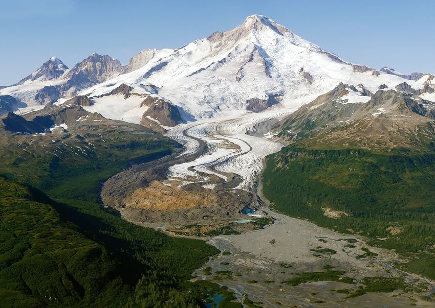
ON THE COVER
View looking west toward Iliamna Volcano and Red Glacier, LACL. The composite type section of the Jurassic Red Glacier
Formation of the Tuxedni Group is located on both sides of Red Glacier. NPS photo by Buck Mangipane.
National Park Service Geologic Type Section
Inventory
Southwest Alaska Inventory & Monitoring Network
Natural Resource Report NPS/SWAN/NRR—2021/2296

Tim Henderson,1 Vincent L. Santucci,1 Tim Connors,2 and Justin S. Tweet3
1
 National Park Service
Geologic Resources Division
1849 “C” Street, NW
Washington, D.C. 20240
2
 National Park Service
Geologic Resources Division
Post Office Box 25287
Denver, Colorado 80225
3
 National Park Service
9149 79th Street S.
Cottage Grove, Minnesota 55016

August 2021

U.S. Department of the Interior
National Park Service
Natural Resource Stewardship and Science
Fort Collins, Colorado
The National Park Service, Natural Resource Stewardship and Science office in Fort Collins,
Colorado, publishes a range of reports that address natural resource topics. These reports are of
interest and applicability to a broad audience in the National Park Service and others in natural
resource management, including scientists, conservation and environmental constituencies, and the
public.

The Natural Resource Report Series is used to disseminate comprehensive information and analysis
about natural resources and related topics concerning lands managed by the National Park Service.
The series supports the advancement of science, informed decision-making, and the achievement of
the National Park Service mission. The series also provides a forum for presenting more lengthy
results that may not be accepted by publications with page limitations.

All manuscripts in the series receive the appropriate level of peer review to ensure that the
information is scientifically credible and technically accurate.

Views, statements, findings, conclusions, recommendations, and data in this report do not necessarily
reflect views and policies of the National Park Service, U.S. Department of the Interior. Mention of
trade names or commercial products does not constitute endorsement or recommendation for use by
the U.S. Government.

This report is available in digital format from the Southwest Alaska Inventory and Monitoring
Network and Natural Resource Publications Management websites. If you have difficulty accessing
information in this publication, particularly if using assistive technology, please email
irma@nps.gov.

Please cite this publication as:

Henderson, T., V. L. Santucci, T. Connors, and J. S. Tweet. 2021. National Park Service geologic
type section inventory: Southwest Alaska Inventory & Monitoring Network. Natural Resource
Report NPS/SWAN/NRR—2021/2296. National Park Service, Fort Collins, Colorado.
https://doi.org/10.36967/nrr-2287220.

NPS 953/177180, August 2021

                                                   ii
Contents
                                                                                                                                                      Page

Figures.................................................................................................................................................... v

Tables ................................................................................................................................................... vii

Photographs.......................................................................................................................................... vii

Executive Summary .............................................................................................................................. ix

Acknowledgments...............................................................................................................................xiii

Dedication ............................................................................................................................................ xv

Introduction ............................................................................................................................................ 1

Geology and Stratigraphy of the SWAN I&M Network Parks ............................................................. 3

       Precambrian .................................................................................................................................... 4

       Paleozoic ........................................................................................................................................ 4

       Mesozoic ........................................................................................................................................ 4

       Cenozoic ......................................................................................................................................... 6

National Park Service Geologic Resource Inventory ............................................................................ 7

       GRI Products .................................................................................................................................. 7

            Geologic Map Data.................................................................................................................... 7

            Geologic Maps........................................................................................................................... 8

            Source Maps .............................................................................................................................. 8

       GRI GIS Data ................................................................................................................................. 8

       GRI Map Posters ............................................................................................................................ 9

       Use Constraints............................................................................................................................... 9

Methods................................................................................................................................................ 11

       Methodology................................................................................................................................. 11

       Definitions .................................................................................................................................... 16

Alagnak Wild River (ALAG) .............................................................................................................. 17

Aniakchak National Monument and Preserve (ANIA) ........................................................................ 21

Katmai National Park and Preserve (KATM) ...................................................................................... 27

                                                                             iii
Contents (continued)
                                                                                                                                                Page

Kenai Fjords National Park (KEFJ) ..................................................................................................... 35

Lake Clark National Park and Preserve (LACL) ................................................................................. 39

Recommendations ................................................................................................................................ 49

Literature Cited .................................................................................................................................... 51

Appendix A: Source Information for GRI Maps of SWAN Parks ...................................................... 55

Appendix B: Geologic Time Scale ...................................................................................................... 59

                                                                          iv
Figures
                                                                                                                                                Page

Figure 1. Map of Southwest Alaska I&M Network parks including: Alagnak Wild River
(ALAG), Aniakchak National Monument and Preserve (ANIA), Katmai National Park
and Preserve (KATM), Kenai Fjords National Park (KEFJ), and Lake Clark National
Park and Preserve (LACL)..................................................................................................................... 3

Figure 2. Correlation chart of Mesozoic stratigraphic units, Alaska Peninsula. ................................... 5

Figure 3. Correlation chart of Tertiary stratigraphic units, Alaska Peninsula....................................... 6

Figure 4. Screenshot of digital geologic map of Kenai Fjords National Park listing
mapped units. ....................................................................................................................................... 12

Figure 5. GEOLEX search result for the Kaguyak Formation............................................................ 13

Figure 6. Stratotype inventory spreadsheet of the SWAN displaying attributes
appropriate for geolocation assessment. .............................................................................................. 15

Figure 7. Park map of ALAG, Alaska................................................................................................. 18

Figure 8. Geologic map of ALAG, Alaska. ........................................................................................ 19

Figure 9. Park map of ANIA, Alaska.................................................................................................. 22

Figure 10. Geologic map of ANIA, Alaska. ....................................................................................... 23

Figure 11. Modified geologic map of ANIA showing stratotype locations. ....................................... 25

Figure 12. Park map of KATM, Alaska. ............................................................................................. 28

Figure 13. Geologic map of KATM and ALAG, Alaska. ................................................................... 29

Figure 14. Geologic map legend of KATM and ALAG, Alaska. ....................................................... 30

Figure 15. Modified geologic map of KATM showing stratotype locations. ..................................... 32

Figure 16. Type section cliff exposure of the Kaguyak Formation (Kk) between Big
River and Swikshak River along Swikshak Bay, KATM. ................................................................... 34

Figure 17. Park map of KEFJ, Alaska................................................................................................. 36

Figure 18. Geologic map of KEFJ, Alaska. ........................................................................................ 37

Figure 19. Park map of LACL, Alaska. .............................................................................................. 40

Figure 20. Geologic map of LACL, Alaska. ....................................................................................... 41

Figure 21. Geologic map legend of LACL, Alaska. ........................................................................... 42

Figure 22. Modified geologic map of LACL showing stratotype locations. ...................................... 44

                                                                           v
Figures (continued)
                                                                                                                                              Page

Figure 23. Aerial view looking east across tidal flats in Tuxedni Bay, LACL. .................................. 45

Figure 24. View looking north across Chinitna Bay at the mouth of Middle Glacier
Creek, LACL........................................................................................................................................ 46

Figure 25. Fossil Point, prominent northeast promontory along the south shore of
Tuxedni Bay, LACL. ........................................................................................................................... 47

Figure 26. Westward view of Iliamna Volcano and Red Glacier, LACL. .......................................... 48

                                                                         vi
Tables
                                                                                                                                                 Page

Table 1. List of SWAN stratotype units sorted by age with associated reference
publications and locations. ..................................................................................................................... x

Table 2. List of ANIA stratotype units sorted by age with associated reference
publications and locations. ................................................................................................................... 24

Table 3. List of KATM stratotype units sorted by age with associated reference
publications and locations. ................................................................................................................... 31

Table 4. List of LACL stratotype units sorted by age with associated reference
publications and locations. ................................................................................................................... 43

Photographs
                                                                                                                                                 Page

Ric Wilson .......................................................................................................................................... xvi

                                                                          vii
Executive Summary
A fundamental responsibility of the National Park Service (NPS) is to ensure that park resources are
preserved, protected, and managed in consideration of the resources themselves and for the benefit
and enjoyment by the public. Through the inventory, monitoring, and study of park resources, we
gain a greater understanding of the scope, significance, distribution, and management issues
associated with these resources and their use. This baseline of natural resource information is
available to inform park managers, scientists, stakeholders, and the public about the conditions of
these resources and the factors or activities that may threaten or influence their stability and
preservation.

There are several different categories of geologic or stratigraphic units (supergroup, group,
formation, member, bed) that form a hierarchical system of classification. The mapping of
stratigraphic units involves the evaluation of lithologies, bedding properties, thickness, geographic
distribution, and other factors. Mappable geologic units may be described and named through a
rigorously defined process that is standardized and codified by the professional geologic community
(North American Commission on Stratigraphic Nomenclature 2005). In most instances when a new
geologic unit such as a formation is described and named in the scientific literature, a specific and
well-exposed section or exposure area of the unit is designated as the stratotype (see “Definitions”
below). The type section is an important reference exposure for a named geologic unit which
presents a relatively complete and representative example for this unit. Geologic stratotypes are
important both historically and scientifically, and should be available for other researchers to
evaluate in the future.

The inventory of all geologic stratotypes throughout the 423 units of the NPS is an important effort in
documenting these locations in order that NPS staff recognize and protect these areas for future
studies. The focus adopted for completing the baseline inventories throughout the NPS was centered
on the 32 inventory and monitoring networks (I&M) established during the late 1990s. The I&M
networks are clusters of parks within a defined geographic area based on the ecoregions of North
America (Fenneman 1946; Bailey 1976; Omernik 1987). These networks share similar physical
resources (e.g., geology, hydrology, climate), biological resources (e.g., flora, fauna), and ecological
characteristics. Specialists familiar with the resources and ecological parameters of the network, and
associated parks, work with park staff to support network level activities such as inventory,
monitoring, research, and data management.

Adopting a network-based approach to inventories worked well when the NPS undertook
paleontological resource inventories for the 32 I&M networks. The planning team from the NPS
Geologic Resources Division who proposed and designed this inventory selected the Greater
Yellowstone Inventory and Monitoring Network (GRYN) as the pilot network for initiating this
project. Through the research undertaken to identify the geologic stratotypes within the parks of the
GRYN methodologies for data mining and reporting on these resources were established.
Methodologies and reporting adopted for the GRYN have been used in the development of this report
for the Southwest Alaska Inventory & Monitoring Network (SWAN).

                                                  ix
The goal of this project is to consolidate information pertaining to geologic stratotypes which occur
within NPS-administered areas, in order that this information is available throughout the NPS to
inform park managers and promote the preservation and protection of these important geologic
references and geologic heritage resources. The review of stratotype occurrences for the SWAN
shows there are currently no designated stratotypes for ALAG and KEFJ; ANIA has one type section
and one reference section; KATM has four type sections, one type locality, and one reference
section; and LACL has seven type sections (Table 1).
This report includes recommendations that address outstanding issues and future steps regarding park
unit stratotypes. These recommendations will hopefully guide decision-making and help ensure that
these geoheritage resources are properly protected and that proposed park activities or development
will not adversely impact the stability and condition of these geologic exposures.
Table 1. List of SWAN stratotype units sorted by age with associated reference publications and
locations.
Unit Name (map symbol) Reference Stratotype Location Age
Type section: on the southern shore of Naknek
Lake, where exposures extend from
approximately 0.7 km (0.4 mi) north to 5.2 km
(3.2 mi) northwest of Brooks Camp; type
section on east side of fault.
Parrish et al. Paleocene–
Ketavik Formation Reference section: on the southern shore of
2010 Eocene
Naknek Lake, where exposures extend from
approximately 0.7 km (0.4 mi) north to 5.2 km
(3.2 mi) northwest of Brooks Camp; reference
section on west side of fault.
Type locality: nears Brooks Camps, KATM.
Type section: Swikshak Bay along sea cliffs
Late
from Big River to Swikshak River [secs. 19 and
Keller and Cretaceous,
Kaguyak Formation (Kks) 20, T. 18 S., R. 27 W., and secs. 13 and 14, T.
Reiser 1959 early
18 S., R. 28 W., Afognak C-6 Quadrangle
Maastrichtian
(scale 1:63,360)], AK. Within KATM.
Type section: in sea cliff, Katmai Bay, along
north edge of section 26, Township 25 South, Early
Detterman et al.
Pedmar Formation (Kp) Range 34 West, Mount Katmai A-3 Quadrangle Cretaceous,
1996
(scale 1:63,360), Alaska Peninsula, AK. Within Albian
KATM.
xTable 1 (continued). List of SWAN stratotype units sorted by age with associated reference publications
and locations.
Unit Name (map symbol) Reference Stratotype Location Age
Type section: exposures on unnamed mountain
Katolinat Conglomerate on northeast shore of Grosvenor Lake, in secs.
Detterman et al. Late Jurassic,
Member, Naknek 33 and 34, T. 17 S., R. 35 W., Mount Katmai C-
1996 late(?) Tithonian
Formation (Jnk) 4 Quadrangle (scale 1:63,360), Alaska
Peninsula, AK. Within KATM.
Type section (composite): north and south
Late Jurassic,
Pomeroy Arkose Member, Detterman and sides of Chinitna Bay, Seldovia D-8
early
Naknek Formation (Jnp) Hartsock 1966 Quadrangle, Iniskin Peninsula, AK. Within
Kimmeridgian
LACL.
Reference section: along Northeast Creek (~1
km [0.6 mi] north of Northeast Creek Sandstone
Snug Harbor Siltstone Member type section), on top of and extending Late Jurassic,
Detterman et al.
Member, Naknek down the southeast face of flat-topped ridge, in Kimmeridgian–
1996
Formation (Jns) sec. 27, T. 37 S., R. 51 W., Sutwik Island D-5 late Oxfordian
Quadrangle (scale 1:63,360), Alaska Peninsula,
AK. Within ANIA.
Type section: on east-facing ridge and
Northeast Creek extending down to tributary of Northeast Creek,
Detterman et al. Late Jurassic,
Sandstone Member, in sec. 34, T. 37 S., R. 51 W., Sutwik Island D-5
1996 Oxfordian
Naknek Formation (Jnn) Quadrangle (scale 1:63,360), Alaska Peninsula,
AK. Within ANIA.
Martin and Katz
Type section: exposures in the bluffs along the Middle Jurassic,
Chinitna Formation (Jct) 1912; Detterman
north shore of Chinitna Bay, AK. Within LACL. Callovian
and Reed 1980
Type section: bluffs along the south shore of Middle Jurassic,
Martin and Katz
Tuxedni Sandstone the western arm of Tuxedni Bay, Iliamna Bajocian–
1912
region, AK. Within LACL. Bathonian
Type section (composite): along both sides of
Red Glacier, AK. Within LACL.
1. Upper 1,009 m (3,310 ft) exposed along
Detterman 1963;
Red Glacier Formation south side of Red Glacier, 7.2 km (4.5 mi) S.
Detterman and Middle Jurassic
(Jtrg) 62° E. of lliamna Volcano;
Hartsock 1966
2. Lower 375 m (1,230 ft) on north side of Red
Glacier, 10.5 km (6.5 mi) N. 86° E. of Iliamna
Volcano.
Type section: Horn Mountain, from the shore of
Horn Mountain Tuff Chinitna Bay to the peak of Horn Mountain and
Detterman and
Member, Talkeetna north along the ridge to the contact with Early Jurassic
Hartsock 1966
Formation (Jtkh) Portage Creek Agglomerate Member, Iniskin–
Tuxedni region, AK. Within LACL.
Type section: on south shore of Tuxedni Bay.
Portage Creek
Section starts about 3.9 km (2.4 mi) northwest
Agglomerate Member, Detterman and
of Fossil Point and continues along shoreline to Early Jurassic
Talkeetna Formation Hartsock 1966
contact with underlying Marsh Creek Member,
(Jtkp)
Iniskin Peninsula, AK. Within LACL.
xiTable 1 (continued). List of SWAN stratotype units sorted by age with associated reference publications
and locations.
Unit Name (map symbol) Reference Stratotype Location Age
Type section: along south shore of Tuxedni
Marsh Creek Breccia Bay, starting 9.6 km (6 mi) northwest of Fossil
Detterman and
Member, Talkeetna Point and continuing 3.6 km (2.25 mi) to contact Early Jurassic
Hartsock 1966
Formation (Jtkm) with quartz diorite pluton, Cook Inlet region, AK.
Within LACL.
xiiAcknowledgments
Many individuals were consulted in the preparation of this report on the geologic stratotypes for the
national parks of the Southwest Alaska Inventory and Monitoring Network. We first want to extend
our sincere appreciation to Randy Orndorff, David Soller, and Nancy Stamm (U.S. Geological
Survey) for their assistance with this geologic stratotype inventory and other NPS projects. Randy,
Nancy and David manage the National Geologic Map Database for the United States (NGMDB,
https://ngmdb.usgs.gov/ngm-bin/ngm_compsearch.pl?glx=1) and the U.S. Geologic Names Lexicon
(“GEOLEX”, https://ngmdb.usgs.gov/Geolex/search), the national compilation of names and
descriptions of geologic units for the United States, two critical sources of geologic information for
science, industry, and the American public. We also extend our appreciation to Travis Hudson
(USGS retired) and Frederic (Ric) Wilson (USGS) for their professional expertise and input in
reviewing this report.
We thank our colleagues and partners in the Geological Society of America (GSA) and Stewards
Individual Placement Program for their continued support to the NPS with the placement of geologic
interns and other ventures. Additionally, we are grateful to Rory O’Connor-Walston and Alvin
Sellmer from the NPS Technical Information Center in Denver for their assistance with locating
hard-to-find publications.
Thanks to our NPS colleagues in the Southwest Alaska Inventory and Monitoring Network and
various network parks, including Amy Miller (SWAN Coordinator). Additional thanks to Robert
Blodgett for his continued support for this and other important geology projects of the NPS.
This project is possible through the support from research associates and staff in the National Park
Service Geologic Resources Division and we extend our thanks to Hal Pranger, Julia Brunner, Jason
Kenworthy, and Jim Wood.
xiiiDedication
This Southwest Alaska Inventory and Monitoring Network Geologic Type Section Inventory is
dedicated to USGS geologist Frederic (Ric) Wilson.
Ric joined the Alaska Branch of the USGS in 1975 while a graduate student at the University of
Alaska and moved to Menlo Park, California to become a potassium–argon geochronologist. After
completing his Ph.D., Ric returned to Alaska in 1980 to build an argon extraction lab in Anchorage.
Ric followed his dream to develop into a generalist; running projects in resource assessment,
providing geochron support, and his favorite (geologic mapping and compilation). Back in the day,
unable to use a Leroy lettering device for his first geologic map (they are extremely right-handed and
Ric is left-handed), he worked to develop digital methods to overcome those challenges. Those tools
ultimately led to the design of the database underlying the Alaska geologic maps that Ric has
produced.
The thing Ric loves most about Alaskan geology is the variety, the history, and the complexity. He
especially likes to try to envision what Alaska looked like at various times throughout geologic time.
The geology of southwest Alaska, especially the Alaska Peninsula and Aleutian Islands, draws him
in. Recently, Ric has been involved in an effort similar to the Alaska map in the Caribbean, but it is a
poor trade to exchange glacial deposits for saprolite!
Ric’s proudest accomplishment was the publication of the Geologic Map of Alaska (USGS SIM-
3340) and its underlying digital database; the outcome of a long effort supported by numerous active
and especially Emeritus USGS scientists. Ric is proud to have stood on the shoulders of giants,
especially Robert Detterman and Florence Weber.
xvRic Wilson
xviIntroduction
The NPS Geologic Type Section Inventory Project (“Stratotype Inventory Project”) is a continuation
of and complements other work performed by the Geologic Resources Inventory (GRI). The GRI is
funded by the NPS Inventory & Monitoring Program and administered by the Geologic Resources
Division (GRD). The GRI is designed to compile baseline geologic resource information and make it
available to park managers, and advance science-informed management of natural resources in the
national parks. The goals of the GRI team are to increase understanding and appreciation of the
geologic features and processes in parks and to provide robust geologic information for use in park
planning, decision making, public education, and resource stewardship.
Documentation of stratotypes (i.e., type sections/type localities/type areas) that occur within national
park boundaries represents a significant component of a geologic resource inventory, as these
designations serve as the standard for defining and recognizing geologic units (North American
Commission on Stratigraphic Nomenclature 2005). The importance of stratotypes lies in the fact that
they represent important comparative sites where past investigations can be built upon or re-
examined, and can serve as teaching sites for the next generation of students (Brocx et al. 2019). The
geoheritage significance of stratotypes is analogous to libraries and museums in that they are natural
repositories of Earth history and record the physical and biologic evolution of our planet.
The goals of this project are to (1) systematically report the assigned stratotypes that occur within
national park boundaries, (2) provide detailed descriptions of the stratotype exposures and their
locations, and (3) reference the stratotype assignments from published literature. It is important to
note that this project cannot verify a stratotype for a geologic unit if one has not been formally
assigned and/or published. Additionally, numerous stratotypes are located geographically outside of
national park boundaries, but only those within 48 km (30 mi) of park boundaries are presented in
this report.
This geologic type section inventory for the parks of the Southwest Alaska Inventory & Monitoring
Network (SWAN) follows standard practices, methodologies, and organization of information
introduced in the Greater Yellowstone I&M Network type section inventory (Henderson et al. 2020).
All network-specific reports are prepared, peer-reviewed, and submitted to the Natural Resources
Stewardship and Science Publications Office for finalization. A small team of geologists and
paleontologists from the NPS Geologic Resources Division and the NPS Paleontology Program have
stepped up to undertake this important inventory for the NPS.
This inventory fills a void in basic geologic information compiled by the NPS at most parks.
Instances where geologic stratotypes occurred within NPS areas were determined through research of
published geologic literature and maps. Sometimes the lack of specific locality or other data limited
determination of whether a particular stratotype was located within NPS administered boundaries.
Below are the primary justifications that warrant this inventory of NPS geologic stratotypes.
1● Geologic stratotypes are a part of our national geologic heritage and are a cornerstone of the
scientific value used to define the societal significance of geoheritage sites
(https://www.nps.gov/articles/scientific-value.htm);
● Geologic stratotypes are important geologic landmarks and reference locations that define
important scientific information associated with geologic strata. Geologic formations are
commonly named after topographic or geologic features and landmarks that are recognizable
to park staff;
● Geologic stratotypes are both historically and scientifically important components of earth
science investigations and mapping. Geologic stratotypes are similar in nature to type
specimens in biology and paleontology, serving as the primary reference for defining
distinctive characteristics and establishing accurate comparisons;
● Understanding and interpretation of the geologic record depends upon the stratigraphic
occurrences of mappable lithologic units (formations, members). These geologic units are the
foundational attributes of geologic maps;
● Geologic maps are important tools for science, resource management, land use planning, and
other areas and disciplines;
● Geologic stratotypes within NPS areas have not been previously inventoried and there is a
general absence of baseline information for this geologic resource category;
● NPS staff may not be aware of the concept of geologic stratotypes and therefore would not
understand the significance or occurrence of these natural references in the parks;
● Given the importance of geologic stratotypes as geologic references and geologic heritage
resources, these locations should be afforded some level of preservation or protection when
they occur within NPS areas;
● If NPS staff are unaware of geologic stratotypes within parks, the NPS cannot proactively
monitor the stability, condition, or potential impacts to these locations during normal park
operations or planning. This also prevents the protection of these localities from activities
which may involve ground disturbance or construction.
● This inventory can inform important conversations on whether geologic stratotypes rise to the
level of national register documentation. The NPS should consider if any other legal authorities
(e.g., National Historic Preservation Act), policy, or other safeguards currently in place can
help protect geologic stratotypes that are established on NPS administered lands. Through this
inventory, the associated report, and close communication with park and I&M Network staff,
the hope is there will be an increased awareness about these important geologic landmarks in
parks. In turn, the awareness of these resources and their significance may be recognized in
park planning and operations, to ensure that geologic stratotypes are preserved and available
for future study.
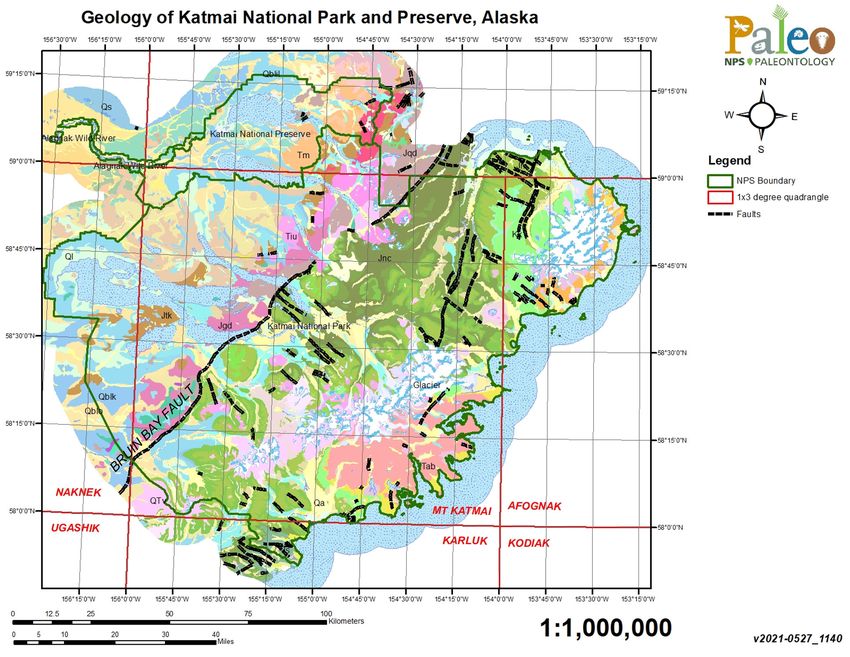
2Geology and Stratigraphy of the SWAN I&M Network Parks
The Southwest Alaska Inventory and Monitoring Network (SWAN) includes five national park units
located on the Alaska and Kenai peninsulas of southwestern Alaska. The five NPS units are Alagnak
Wild River (ALAG), Aniakchak National Monument and Preserve (ANIA), Katmai National Park
and Preserve (KATM), Kenai Fjords National Park (KEFJ), and Lake Clark National Park and
Preserve (LACL) (Figure 1). Collectively, the SWAN park units encompass approximately 3.8
million hectares (9.4 million acres) and preserve exceptional geologic features, landforms, marine
coastlines, aquatic systems, wilderness, flora, and fauna.
Figure 1. Map of Southwest Alaska I&M Network parks including: Alagnak Wild River (ALAG), Aniakchak
National Monument and Preserve (ANIA), Katmai National Park and Preserve (KATM), Kenai Fjords
National Park (KEFJ), and Lake Clark National Park and Preserve (LACL) (NPS).
The SWAN park units preserve a wide variety of geologic features and landscapes including
mountains, volcanoes, and glaciers. ANIA preserves a large 3,600-year-old volcanic caldera along
the volcanic arc of the Alaska Peninsula and Aleutian Islands. KATM preserves the Valley of Ten
Thousand Smokes, Katmai caldera, and Novarupta which formed during the largest volcanic eruption
3of the 20th century. KEFJ preserves the extensive Harding Ice Field. Geologic Resource Inventory
reports for ALAG and KATM (Hults and Fierstein 2016), ANIA (Hults and Neal 2015), KEFJ
(Lanik et al. 2018), and LACL (Lanik et al. in press) present detailed information on the geologic
resources of these SWAN park units.
Precambrian
Precambrian rocks are not exposed in any of the parks in SWAN (see Appendix B for a geologic
time scale).
Paleozoic
The only Paleozoic rocks documented in SWAN include low-grade metamorphic rocks of Paleozoic
through Jurassic age that occur at ALAG and KATM.
Mesozoic
The Late Triassic-age Kamishak Formation and Cottonwood Bay Greenstone are exposed at or near
KATM and LACL (Figure 2). Additionally, the Late Triassic Chilikadrotna Greenstone and the
Tlikakila complex and other unnamed metamorphic rocks are present at LACL (Wilson et al. 2015).
Jurassic rocks are documented at ANIA, KATM, and LACL. The Early Jurassic Talkeetna Formation
occurs at both KATM and LACL (Figure 2). The Middle Jurassic is represented at KATM by the
Shelikof Formation, and a half-dozen Middle Jurassic formations within the Tuxedni Group are
mapped at LACL (Wilson et al. 2015). The Late Jurassic Naknek Formation is mapped at ANIA,
KATM, and LACL (Figure 2). Extensive Jurassic and Cretaceous plutonic rocks are mapped in
LACL and KATM (Wilson et al. 2015).
Rocks of Early Cretaceous age are represented by the Staniukovich, Herendeen and Pedmar
Formations at KATM, and igneous dikes at KEFJ span from the Early Cretaceous into the Cenozoic
(Figure 2). Late Cretaceous units include the Hoodoo and Chignik Formations at ANIA, the Valdez
Group at KEFJ, the Kuskokwim Group at LACL, and the Kaguyak Formation at KATM and LACL
(Figure 2; Wilson et al. 2015).
4Figure 2. Correlation chart of Mesozoic stratigraphic units, Alaska Peninsula. Figure modified from
Detterman et al. (1996: Figure 4).
5Cenozoic
Igneous rocks are documented during the Cenozoic for all the SWAN parks. Paleocene and Eocene
units include the Tolstoi Formation (ANIA), Copper Lake Formation (KATM), and West Foreland
Formation (LACL) (Figure 3). Granitic rocks of the Harding Icefield region date to the Paleocene
and Eocene. The Meshik Volcanics, which range in age from Middle Eocene to Early Oligocene, are
documented in ANIA, KATM and LACL (Figure 3). The Hemlock Conglomerate is a Late
Oligocene unit at KATM. The Tyonek Formation is a Late Oligocene–Middle Miocene unit mapped
at LACL. The Gibraltar Lake Tuff at KATM is between Oligocene and Pliocene in age, though likely
Pliocene. Quaternary surficial units occur in all of the SWAN park units (Wilson et al. 2015).
Figure 3. Correlation chart of Tertiary stratigraphic units, Alaska Peninsula. Figure modified from
Detterman et al. (1996: Figure 12).
6National Park Service Geologic Resource Inventory
The Geologic Resources Inventory (GRI) provides digital geologic map data and pertinent geologic
information on park-specific features, issues, and processes to support resource management and
science-informed decision-making in more than 270 natural resource parks throughout the National
Park System. The GRI is one of 12 inventories funded by the National Park Service (NPS) Inventory
and Monitoring Program. The Geologic Resources Division (GRD) of the NPS Natural Resource
Stewardship and Science Directorate administers the GRI. The GRI team consists of a partnership
between the GRD and the Colorado State University Department of Geosciences to produce GRI
products.
GRI Products
The GRI team undertakes three tasks for each park in the Inventory and Monitoring program: (1)
conduct a scoping meeting and provide a summary document, (2) provide digital geologic map data
in a geographic information system (GIS) format, and (3) provide a GRI report. These products are
designed and written for non-geoscientists.
Scoping meetings bring together park staff and geologic experts to review and assess available
geologic maps, develop a geologic mapping plan, and discuss geologic features, processes, and
resource management issues that should be addressed in the GRI report. Scoping sessions were held
for all of the SWAN park units between February 14–18, 2005.
Following the scoping meeting, the GRI map team converts the geologic maps identified in the
mapping plan to GIS data in accordance with the GRI data model. After the map is completed, the
GRI report team uses these data, as well as the scoping summary and additional research, to prepare
the GRI report. As of 2020, GRI reports have been completed for ANIA, ALAG, KATM, and KEFJ;
LACL is scheduled for publication in FY 2021. The GRI team conducts no new field work in
association with their products.
The compilation and use of natural resource information by park managers is called for in the 1998
National Parks Omnibus Management Act (§ 204), 2006 National Park Service Management
Policies, and the Natural Resources Inventory and Monitoring Guideline (NPS-75). Additional
information regarding the GRI, including contact information, is available at
https://www.nps.gov/subjects/geology/gri.htm.
Geologic Map Data
A geologic map in GIS format is the principal deliverable of the GRI program. GRI GIS data
produced for the SWAN parks follows the selected source maps and includes components such as:
faults, mine area features, mine point features, geologic units (bedrock, surficial, glacial), geologic
contacts, geologic line features, structure contours, and so forth. These are commonly acceptable
geologic features to include in a geologic map.
7Posters display the data over imagery of the park and surrounding area. Complete GIS data are
available at the GRI publications website: https://www.nps.gov/subjects/geology/geologic-resources-
inventory-products.htm.
Geologic Maps
A geologic map is the fundamental tool for depicting the geology of an area. Geologic maps are two-
dimensional representations of the three-dimensional geometry of rock and sediment at, or beneath
the land surface (Evans 2016). Color and sometimes symbols on geologic maps are used to
distinguish geologic map units. The unit labels consist of an uppercase letter (or symbol for some
ages) indicating the geologic age and lowercase letters indicating the formation’s name. Other
symbols depict structures such as faults or folds, locations of past geologic hazards that may be
susceptible to future activity, and other geologic features. Anthropogenic features such as mines or
quarries, as well as observation or collection locations, may be indicated on geologic maps. The
American Geosciences Institute website
(https://www.americangeosciences.org/environment/publications/mapping) and work by Bernknopf
et al. (1993) provide more information about the usage and societal value of geologic maps.
Geologic maps are typically one of three types: surficial, bedrock, or a combination of both. Surficial
geologic maps typically encompass deposits that are unconsolidated and which formed during the
past 2.6 million years (the Quaternary Period). Surficial map units are differentiated by geologic
process or depositional environment. Bedrock geologic maps encompass older, typically more
consolidated sedimentary, metamorphic, and/or igneous rocks. Bedrock map units are differentiated
based on age and/or rock type, geologic processes, and/or depositional environment. GRI has
produced various maps for the SWAN parks.
Source Maps
The GRI team does not conduct original geologic mapping. The team digitizes paper maps and
compiles and converts digital data to conform to the GRI GIS data model. The GRI GIS dataset
includes essential elements of the source maps such as map unit descriptions, a correlation chart of
units, a map legend, map notes, cross sections, figures, and references. These items are typically
included in a master geology document (PDF) for a specific park. The GRI team uses a unique
“GMAP ID” value for each geologic source map, and all sources used to produce the GRI GIS
datasets for the SWAN parks can be found in Appendix A.
GRI GIS Data
The GRI team standardizes map deliverables by using a data model. The most recent GRI GIS data
for ALAG, KATM, and LACL was compiled using data model version 2.3, which is available at
https://www.nps.gov/articles/gri-geodatabase-model.htm; the ANIA and KEFJ data are based on
older data models and need to be upgraded to the most recent version. The data model dictates the
GIS data structure, including layer architecture, feature attribution, and relationships within ESRI
ArcGIS software. The GRI website (https://www.nps.gov/subjects/geology/gri.htm) provides more
information about the program’s products.
8GRI GIS data are available on the GRI publications website
(https://www.nps.gov/subjects/geology/geologic-resources-inventory-products.htm) and through the
NPS Integrated Resource Management Applications (IRMA) Data Store portal
(https://irma.nps.gov/DataStore/Search/Quick). Enter “GRI” as the search text and select ALAG,
ANIA, KATM, KEFJ, or LACL from the unit list.
The following components are part of the data set:
● A GIS readme file that describes the GRI data formats, naming conventions, extraction
instructions, use constraints, and contact information;
● Data in ESRI geodatabase GIS format;
● Layer files with feature symbology;
● Federal Geographic Data Committee (FGDC)-compliant metadata;
● An ancillary map information document that contains information captured from source maps
such as map unit descriptions, geologic unit correlation tables, legends, cross-sections, and
figures;
● ESRI map documents that display the GRI GIS data; and
● A version of the data viewable in Google Earth (.kml / .kmz file)
GRI Map Posters
Selected geologic data is draped over shaded relief images of the park and surrounding area to create
a poster included in GRI reports. Geographic information and selected park features have been added
to the posters. Digital elevation data and added geographic information are not included in the GRI
GIS data, but are available online from a variety of sources. Contact GRI for assistance locating these
data.
Use Constraints
Graphic and written information provided in this report is not a substitute for site-specific
investigations. Ground-disturbing activities should neither be permitted nor denied based upon the
information provided in the GRI posters. Please contact GRI with any questions.
Minor inaccuracies may exist regarding the locations of geologic features relative to other geologic
or geographic features on the posters. Based on the source map scales (1:250,000, 1:100,000,
1:63,360, and 1:24,000) and U.S. National Map Accuracy Standards
(https://pubs.usgs.gov/fs/1999/0171/report.pdf), geologic features represented in the geologic map
data are expected to be horizontally within 51 m (167 ft), 32 m (104 ft), and 12 m (40 ft),
respectively, of their true locations.
9Methods
We describe here the methods employed and definitions adopted during this inventory of geologic
stratotypes located within the SWAN parks. This report is part of an inventory of geologic
stratotypes throughout the parks of the National Park System. Therefore, the methods, definitions,
and challenges identified here pertain not only to the park units of SWAN, but are for broader
application throughout the park units of the National Park System.
There are several considerations for this inventory. The most up-to-date information available is
necessary, either found online or in published articles and maps. For some park units specific
information is not available which limits the final report. No fieldwork was done as part of this
inventory, which is therefore dependent on existing information for individual park geology and
stratigraphy. Additionally, this inventory does not attempt to resolve any unresolved or controversial
stratigraphic interpretations, which is beyond the scope of the project.
Stratigraphic nomenclature may change over time with refined stratigraphic field assessments and
discovery of information through the expansion of stratigraphic mapping and measured sections. One
important observation regarding stratigraphic nomenclature relates to differences in use of geologic
names for units which transcend state boundaries. Geologic formations and other units which cross
state boundaries may be referenced with different names in each of the states the units are mapped.
An example would be the Triassic Chugwater Formation in Wyoming, which is equivalent to the
Spearfish Formation in the Black Hills of South Dakota and Wyoming.
The lack of a designated and formal stratotype, or inadequate and vague geospatial information
associated with a stratotype, limits the ability to capture precise information for this inventory. The
available information related to the geologic stratotypes of SWAN is included in this report.
This inventory report is intended for a wide audience, including NPS staff who might not have a
background in geology. Therefore, this document is developed as a reference document that supports
science, resource management, and a historic framework for geologic information associated with
NPS areas.
Methodology
The process of determining whether a specific stratotype occurs in an NPS area involves multiple
steps. The process begins with an evaluation of the existing park-specific GRI map to prepare a full
list of recognized map units (Figure 4).
11Figure 4. Screenshot of digital geologic map of Kenai Fjords National Park listing mapped units.
12Each map unit name is then queried in the U.S. Geologic Names Lexicon online database
(“GEOLEX”, a national compilation of names and descriptions of geologic units) at
https://ngmdb.usgs.gov/Geolex/search. Information provided by GEOLEX includes unit name,
stratigraphic nomenclature usage, geologic age, and published stratotype location descriptions, and
the database provides a link to significant publications as well as the USGS Geologic Names
Committee Archives (Wilmarth 1938; Keroher et al. 1966). Figure 5 below is taken from a search on
the Kaguyak Formation.
Figure 5. GEOLEX search result for the Kaguyak Formation.
Published GEOLEX stratotype spatial information is provided in three formats: (1) descriptive, using
distance from nearby points of interest; (2) latitude and longitude coordinates; or (3)
Township/Range/Section (TRS) coordinates. TRS coordinates are based upon subdivisions of a
13single 93.2 km2 (36 mi2) township into 36 individual 2.59 km2 (1 mi2) sections, and were converted
into Google Earth (.kmz file) locations using Earth Point
(https://www.earthpoint.us/TownshipsSearchByDescription.aspx). They are typically presented in an
abbreviated format such as “sec. [#], T. [#] [N. or S.], R. [#] [E. or W.].” The most accurate
GEOLEX descriptions using TRS coordinates can help locate features within 0.1618 km2 (0.0625
mi2). Once stratotype locality information provided for a given unit is geolocated using Google
Earth, a GRI digital geologic map of the park is draped over it. This step serves two functions: to
improve accuracy in locating the stratotype, and validating the geologic polygon for agreement with
GEOLEX nomenclature. Geolocations in Google Earth are then converted into an ArcGIS format
using a “KML to Layer” conversion tool in ArcMap.
Upon accurately identifying the stratotypes, a Microsoft Excel spreadsheet is populated with
information pertinent to the geologic unit and its stratotype attributes. Attribute data recorded in this
way include: (1) is a stratotype officially designated; (2) is the stratotype on NPS land; (3) has it
undergone a quality control check in Google Earth using a GRI digital geologic map overlay; (4)
reference of the publication citing the stratotype; (5) description of geospatial information; (6)
coordinates of geospatial information; (7) geologic age (era, period, epoch, etc.); (8) hierarchy of
nomenclature (supergroup, group, formation, member, bed, etc.); (9) was the geologic unit found in
GEOLEX; and (10) a generic notes field (Figure 6).
14Figure 6. Stratotype inventory spreadsheet of the SWAN displaying attributes appropriate for geolocation assessment.
15Definitions
In order to clarify, standardize, and consistently reference stratigraphic concepts, principles, and
definitions, the North American Stratigraphic Code is adopted for this inventory. This code describes
explicit practices for classifying and naming all formally defined geologic units. An important
designation for a geologic unit is known as a stratotype–the standard (original or subsequently
designated) basis for definition or recognition of a geologic unit or boundary (North American
Commission on Stratigraphic Nomenclature 2005). There are several variations of stratotypes in the
literature and this report, and they are defined as following:
(1) Unit stratotype: the type section for a stratified deposit or the type area for a non-stratified
body that serves as the standard for recognition and definition of a geologic unit (North American
Commission on Stratigraphic Nomenclature 2005). Once a unit stratotype is assigned, it is never
changed (unless the unit is abandoned). The term “unit stratotype” is commonly referred to as “type
section” and “type area” in this report.
(2) Type locality: the specific geographic locality encompassing the unit stratotype of a formally
recognized and defined unit. On a broader scale, a type area is the geographic territory encompassing
the type locality. Before development of the stratotype concept, only type localities and type areas
were designated for many geologic units that are now long- and well-established (North American
Commission on Stratigraphic Nomenclature 2005).
(3) Reference sections: for well-established geologic units for which a type section was never
assigned, a reference section may serve as an invaluable standard in definitions or revisions. A
principal reference section may also be designated for units whose stratotypes have been destroyed,
covered, or are otherwise inaccessible (North American Commission on Stratigraphic Nomenclature
2005). Multiple reference sections can be designated for a single unit to help illustrate heterogeneity
or some critical feature not found in the stratotype. Reference sections can help supplement unit
stratotypes in the case where the stratotype proves inadequate (North American Commission on
Stratigraphic Nomenclature 2005).
(4) Lithodeme: the term “lithodeme” is defined as a mappable unit of plutonic (igneous rock that
solidified at great depth), highly metamorphosed, or pervasively deformed rock and is a term
equivalent in rank to “formation” among stratified rocks (North American Commission on
Stratigraphic Nomenclature 2005). The formal name of a lithodeme consists of a geographic name
followed by a descriptive term that denotes the average modal composition or lithology of the rock
(example: Cathedral Peak Granodiorite). Lithodemes are commonly assigned type localities, type
areas, and reference localities.
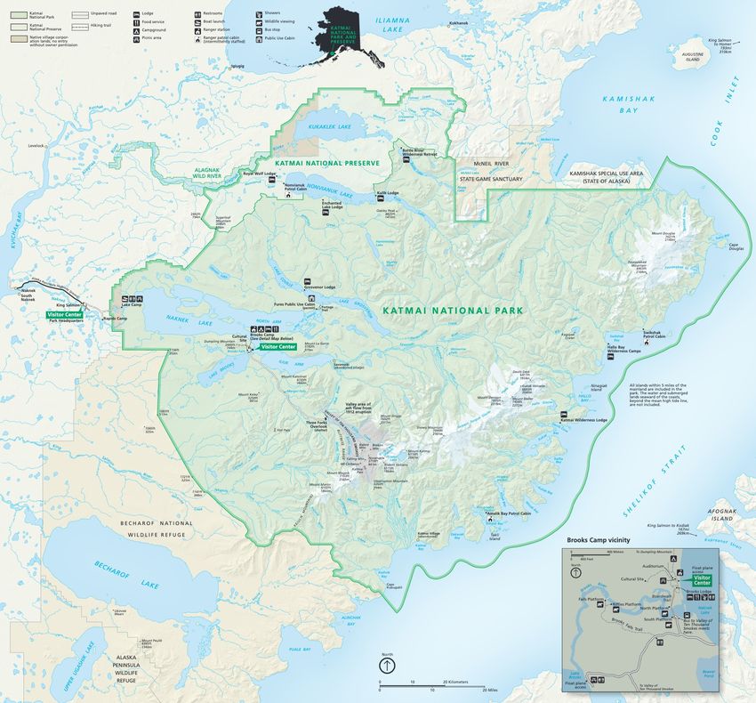
16Alagnak Wild River (ALAG)
Alagnak Wild River (ALAG) is west of the Aleutian Range in the Bristol Bay and Lake and
Peninsula Boroughs, Alaska (Figure 7). Established on December 2, 1980, ALAG encompasses
~12,409 hectares (30,741 acres) and protects 110 km (67 mi) of the Alagnak River, its scenic
landscape, natural features, cultural heritage, and recreational activities (Anderson 2017). The
headwaters of the Alagnak River are in neighboring Katmai National Park and Preserve, where the
river flows northwest from Kukaklek Lake to its confluence with the Kvichak River. The river
system is home to a diverse array of wildlife, including an important sockeye (red) salmon fishery,
and is a critical natural resource for southwest Alaska (Hults and Fierstein 2016).
The geology along the Alagnak River reflects an active landscape shaped by the dynamic forces of
volcanism, glaciation, wind and river erosion, and active tectonics. Geologic units along the Alagnak
River Valley predominantly consist of Pleistocene glacial drift and outwash deposits of the Mak Hill
Glaciation and Brooks Lake Glaciation (Figure 8). The oldest units within the park unit are found
along the northeastern boundary and are the metamorphic rocks of the Late Jurassic and older
Kakhonak Complex. As the Alagnak River flows northwest, exposed units along the river include the
Eocene–Oligocene Meshik Volcanics, Pleistocene glacial deposits, and Quaternary alluvium
(unconsolidated clay, silt, sand, and gravel), alluvial terrace deposits, solifluction deposits (“soil
flow”), abandoned channel deposits, and eolian deposits.
There are no designated stratotypes identified within the boundaries of ALAG. There is one
identified stratotype located within 48 km (30 mi) of ALAG boundaries, for the Jurassic Naknek
Formation (type section).
17Figure 7. Park map of ALAG, Alaska (NPS).
18Figure 8. Geologic map of ALAG, Alaska.
19Aniakchak National Monument and Preserve (ANIA)
Aniakchak National Monument and Preserve (ANIA) is located on the Alaska Peninsula in the Lake
and Peninsula Borough, Alaska (Figure 9). Originally proclaimed as Aniakchak National Monument
on December 1, 1978, the monument was expanded to include the national preserve on December 2,
1980. ANIA includes approximately 244,226 hectares (603,497 acres) of volcanic landscapes,
glaciated mountains, and coastal landforms associated with the Aleutian Range (Anderson 2017).
The park unit namesake, Aniakchak Caldera, is a product of a historically active volcano and
represents one of the best exposed calderas on earth (Hults and Neal 2015). Aniakchak Volcano last
erupted in 1931 through Vent Mountain; the caldera contains lava flows, cinder cones, explosion pits,
and Surprise Lake, the source of the Aniakchak River, whose headwaters cascade through The Gates,
a 457 m (1,500 ft) high breach in the crater wall.
The geology of ANIA consists of sedimentary and igneous rocks that range in age from Late Jurassic
to recent volcanic deposits associated with Aniakchak Caldera (Figure 10). Quaternary volcanic
deposits associated with Aniakchak Volcano blanket a large portion of northwestern ANIA and
predominantly consist of pyroclastic deposits (rocks composed of fragments produced and ejected by
explosive volcanic eruptions) and debris flows. These volcanic deposits have been sculpted by
glaciers and erosion to form amazing landforms (Hults and Neal 2015). The oldest geologic units
exposed in ANIA are primarily located in the northeastern area of the monument just north of Amber
Bay and are of the Late Jurassic Naknek Formation. The Naknek Formation and younger
sedimentary bedrock units of ANIA include marine and non-marine sedimentary rocks that contain
abundant invertebrate fossils, plant fossils, and locally, dinosaur tracks (Hults and Neal 2015).
ANIA contains two identified stratotypes that define the Jurassic Snug Harbor Siltstone and
Northeast Creek Sandstone Members of the Naknek Formation (Table 2; Figure 11). In addition to
the designated stratotypes located within ANIA, stratotypes located within 48 km (30 mi) of park
boundaries include the Jurassic Indecision Creek Sandstone Member of the Naknek Formation (type
section) and Cretaceous Chignik Formation (type area and reference section).
21You can also read