New Metro North Green Line Metro Upgrade - Line B - NMN-GTW-0003_01 - Transport ...
←
→
Page content transcription
If your browser does not render page correctly, please read the page content below
New Metro North

Green Line Metro Upgrade – Line B

NMN-GTW-0003_01
Document Control Information

  Document Title        New Metro North         Green Line Metro Upgrade – Line B
  Filename

  Date             Description   Doc. No.        Rev.       Prepared     Checked    Approved
  27/06/2017       DRAFT         NMN-GTW-0003    01         PB           AF
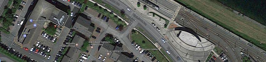
Table of Contents

EXECUTIVE SUMMARY .......................................................................................................... 7
INTRODUCTION ..................................................................................................................... 8
2.1      Study Scope and Objective ........................................................................................... 9
2.2      Luas Green Line Tie-in Study......................................................................................... 9
EXISTING INFRASTRUCTURE ................................................................................................ 11
3.1      Line B (Ranelagh to Sandyford) ................................................................................... 11
3.2      Line B1 (Sandyford to Bride’s Glen) ............................................................................ 11
METRO OPERATING SCENARIOS .......................................................................................... 12
4.1      Scenario 1: 60m LFV – Driver Controlled..................................................................... 12
4.2      Scenario 2: 60m HFV – Fully Automatic ...................................................................... 12
4.3      Scenario 3: 90m LFV – Driver Controlled..................................................................... 13
INFRASTRUCTURE ASSESSMENT .......................................................................................... 13
5.1      Line B (Ranelagh to Sandyford)/Segregation............................................................... 13
5.2      Luas Stop/Platform Modifications .............................................................................. 17
5.3      Sandyford Depot Implications .................................................................................... 26
COST IMPACT ESTIMATE LINE B (RANELAGH TO SANDYFORD)............................................ 29
6.1      Scenario 1: 60m LFV – Driver Controlled..................................................................... 29
6.2      Scenario 2: 60m HFV – Fully Automatic ...................................................................... 31
6.3      Scenario 3: 90m LFV – Driver Controlled..................................................................... 33
6.4      Costs Summary for All Scenarios ................................................................................ 35
CONCLUSION ....................................................................................................................... 36
APPENDICES ........................................................................................................................ 37
8.1      APPENDIX 1: LINE B STUDY AREA SCENARIO 3 STOP ANALYSIS ................................... 37
8.2      APPENDIX 2: LINE B STUDY AREA SCENARIO 3 PLATFORM DRAWINGS ....................... 71
8.3      APPENDIX 3: LINE B STUDY AREA SCENARIO 2 PLATFORM DRAWINGS ....................... 72

                                                                                                                        Page 3 of 72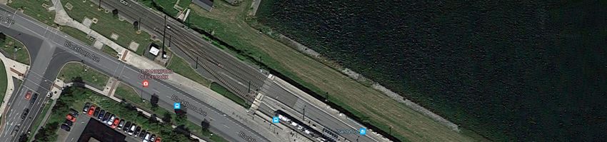
List of Figures

Figure 1: Overall cost estimates for Line B for all scenarios ................................................................ 7
Figure 2: NMN tie-in point at Ranelagh ............................................................................................ 10
Figure 3: NMN tie-in in context with Luas Green Line ...................................................................... 11
Figure 4: Dunville Avenue ................................................................................................................ 14
Figure 5: Access to Alexandra College .............................................................................................. 15
Figure 6: St Raphaela’s Road junction with Luas at Stillorgan ........................................................... 15
Figure 7: Proposed overpass and elevated stop at Stillorgan............................................................ 16
Figure 8: Proposed temporary track for maintaining Luas operations during bridge construction .... 16
Figure 9: Approx. platform edge area to be removed and photo of platform edge ........................... 18
Figure 10: Cross-section through typical upgraded stop (Scenario 2) ............................................... 19
Figure 11: High-floor Copenhagen metro - before and after installation of PSGs .............................. 20
Figure 12: Typical arrangement at upgraded stop (Scenario 2) ......................................................... 20
Figure 13: Ranelagh Stop following upgrade (Scenario 2) ................................................................. 21
Figure 14: Dundrum Stop following upgrade (Scenario 2) ................................................................ 21
Figure 15: Sandyford Stop following upgrade (Scenario 2) ............................................................... 22
Figure 16: Ranelagh passenger access.............................................................................................. 23
Figure 17: Cowper pedestrian passage/crossing .............................................................................. 24
Figure 18: Sandyford Stop extension................................................................................................ 25
Figure 19: Sandyford Depot capacity and modifications for 60m metro vehicles............................... 27
Figure 20: Sandyford Depot capacity and modifications for 90m metro vehicles .............................. 28
Figure 21: Overall cost estimates for Line B for all scenarios ............................................................ 35

                                                         List of Tables

Table 1: Line B Study Area - Scenario 1 Summary ............................................................................. 19
Table 2: Line B Study Area - Scenario 2 Summary ............................................................................. 23
Table 3: Line B Study Area - Scenario 3 Summary ............................................................................. 26

                                                                                                                           Page 4 of 72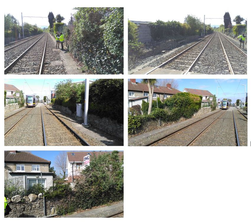
Table 4: Assumptions and Exclusions for Costing Scenario 1 ............................................................ 29
Table 5: Cost Estimate Breakdown – Scenario 1 ............................................................................... 30
Table 6: Assumptions and Exclusions for Costing Scenario 2 ............................................................ 31
Table 7: Cost Estimate Breakdown – Scenario 2 ............................................................................... 32
Table 8: Assumptions and Exclusions for Costing Scenario 2 ............................................................ 33
Table 9: Cost Estimate Breakdown – Scenario 3 ............................................................................... 34

                                                                                                                Page 5 of 72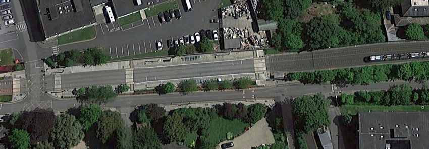
Glossary of Terms/Acronyms

Term            Definition
Bored tunnel    Underground tunnel, excavated by a Tunnel Boring Machine.
Cut and cover   A tunnel or box structure where a trench is excavated to the required dimensions
tunnel/box      and is roofed over with an overhead support system, strong enough to carry the
                load of what is to be built above.
Engineering     A non-service track connection between two rail systems to allow movement of
link            vehicles between them for maintenance or for stabling in a depot.
Track inter-    Where tracks are side-by-side, the track inter-axis is the distance between the
axis            centre points of each track. The wider the distance, the more space there is
                between passing vehicles.
Tunnel portal   The entrance or exit to a tunnel. The interface point between the underground
                tunnel and the ground level.
Segregation     Metro tracks are fully separated from other traffic and from pedestrians. It is an
                essential requirement for the running of high frequency metro vehicles.
Acronym         Definition
AVLS            Automatic Vehicle Location System
DCC             Dublin City Council
DKE             Dynamic Kinetic Envelope
GLCE            (Luas) Green Line Capacity Enhancement
GLIU            (Luas) Green Line Infrastructure Upgrade
HFV             High Floor Vehicle
LFV             Low Floor Vehicle
MS              Metro South
NMN             New Metro North
NTA             National Transport Authority
PPHPD           Passengers per hour, per direction
PSGs            Platform Safety Gates
TBM             Tunnel Boring Machine
TPH             Trains per hour
TII             Transport Infrastructure Ireland

                                                                                      Page 6 of 72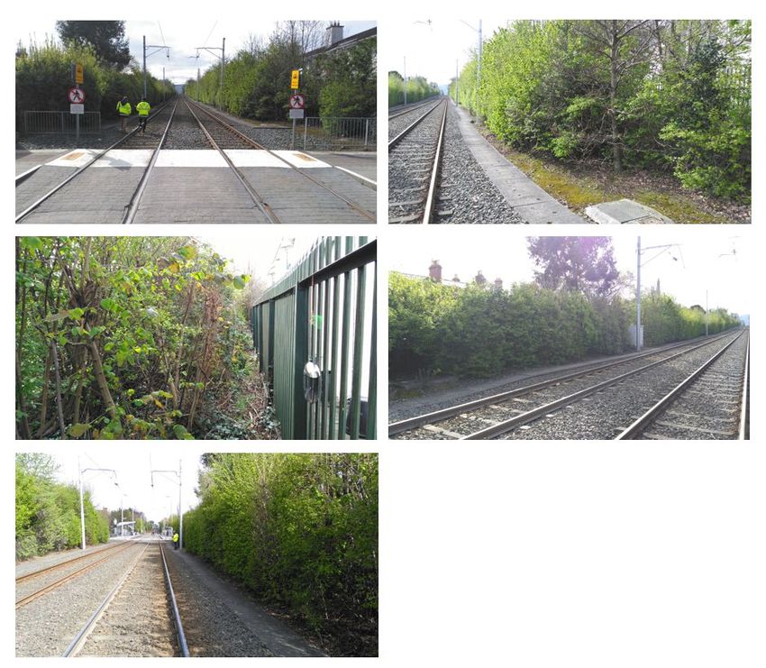
EXECUTIVE SUMMARY
The extent of upgrades required on the Luas Green Line is wholly dependent on the type of system
proposed for New Metro North (NMN); however, at the time of this study, no decision on the type of
vehicle or the mode of operation has been made. Therefore, the objective of this Green Line Metro
Upgrade study is to estimate the costs and identify the extent of work required to upgrade Line B from
Ranelagh to Sandyford for three potential metro operating scenarios, namely:

    1. Scenario 1: 60m long low-floor vehicles, operating similar to the current Luas system with
       minimal additional segregation with the exception of road junctions.
    2. Scenario 2: 60m long high-floor vehicles, operating fully automatic and requiring significant
       infrastructure segregation from road junctions, other vehicles, passengers and pedestrians.
    3. Scenario 3: 90m long low-floor vehicles, operating similar to the current Luas system with
       minimal additional segregation with the exception of road junctions.

Figure 1 provides the estimated costs for converting the line section from Ranelagh and Sandyford to
a metro standard to the extent required by each of the scenarios. In the event that it is deemed that
road segregation is not a requirement for Scenario 1 or 3, estimated costs for each scenario reduce by
€20 million. As Scenario 2 involves a fully automated rail system, full segregation from roads and other
points of interface with pedestrians and vehicles is an absolute requirement.

                      Figure 1: Overall cost estimates for Line B for all scenarios

A large proportion of the additional costs for Scenario 2 arise from the work to extend the platform to
60m, raise the platform heights, install safety gates at platforms and modify access routes to each
platform, including foot bridges and additional lifts (as the track cannot be crossed).

                                                                                           Page 7 of 72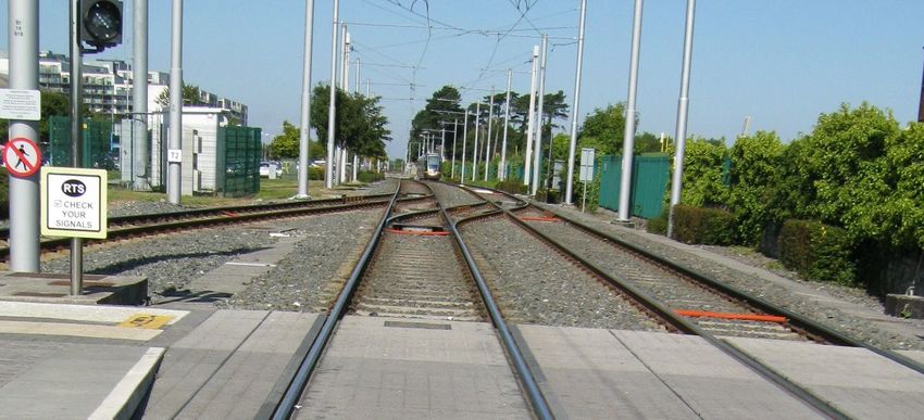
INTRODUCTION
The National Transport Authority’s (NTA) Fingal/North Dublin Study (June 2015), recommended an
optimised Metro North scheme as the preferred public transport solution to service the passenger
demand along the corridor between Dublin City Centre, Dublin Airport and Swords.
The Government’s seven year investment plan titled “Building on Recovery: Infrastructure and Capital
Investment 2016–2021” (October 2015) endorsed this recommendation and included for a new metro
project for Dublin, referred to as “New Metro North” (NMN).
The NTA’s Transport Strategy for the Greater Dublin Area, 2016–2035 (The Strategy) provides a
framework for the planning and delivery of transport infrastructure and services in the Greater Dublin
Area (GDA) over the next two decades. It has built on the work undertaken in the Fingal/North Dublin
Study and undertaken similar studies for all other corridors. In this regard, it provides the context for
the integrated transport network within which NMN will operate.
The Strategy defines NMN as a high speed, high capacity, high frequency public transport link from
the city centre to Dublin Airport and Swords. The city centre section will be underground. As described
in the Strategy, it is anticipated that NMN will ultimately tie into Dublin’s existing Luas Green Line light
rail system, enabling through running of metro trams from Swords to Bride’s Glen.
The Project Objective for NMN as agreed with the NTA is as follows:
“To provide a safe, high frequency, high capacity, fast, efficient, fully segregated and sustainable public
transport light rail service from the city centre to Dublin Airport and Swords.”
In delivering this objective, NMN will:
Cater for existing and future public transport travel demand along this corridor;
Be modern, attractive and accessible to all users;
Be designed to integrate appropriately into the existing public realm;
Be segregated from other transport modes between Dublin Airport and the City Centre;
Contribute to a reduction in urban congestion and the enhancement of the environmental
sustainability of the region;
Support the continued economic development of the Dublin area and the wider State.
Deliver a high quality service with journey-time reliability along the corridor;
Be planned, constructed and operated in an environmentally sustainable manner;
Support public transport network integration by providing high quality passenger interchange
points, which facilitate convenient transfer between public transport services at key locations;
Facilitate connection to key trip attractors; and
Support the strategy for a strategic Park & Ride
Page 8 of 72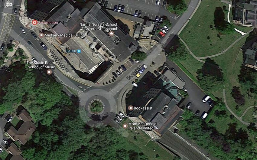
2.1        Study Scope and Objective
The objective of the Luas Green Line Metro Upgrade study is to carry out an engineering feasibility
and costing assessment on upgrading the existing Luas Green Line to a metro standard to facilitate the
through running of metro services from Swords to Bride’s Glen as envisioned in the Strategy.

Within the Strategy (Section 5.5.3), Metro South (MS) is described as an upgrading of the existing Luas
Green Line to metro standard through the extension of NMN southwards, via a tunnel, to join the Luas
Green Line in the Ranelagh area, enabling through running of metro trams from Swords to Bride’s
Glen. The upgrading of the Luas Green Line to metro standard will ensure that growth along this
corridor can be accommodated and, in combination with NMN to Swords, will provide Dublin with a
high capacity, high frequency cross-city rail corridor, serving critical destinations at Dublin Airport,
Dublin City University, Dublin City Centre and Sandyford directly.

The extent of the infrastructure works required to upgrade the current Luas Green Line to a metro
standard, wholly depends on the type of metro system proposed to operate on NMN. At the time of
this study, no decision on the operating characteristics of NMN has been made; therefore, three likely
operating scenarios have been considered for analysis in this study and these are described in detail
in Section 3.2. The existing Luas Green Line can be divided into two sections: Line B which runs from
Ranelagh to Sandyford and Line B1 which runs from Sandyford to Bride’s Glen. The sections differ
considerably in terms of their operating environment. Line B runs within the old railway cutting and is
largely segregated from its surrounds, other than at three locations (Dunville Avenue / Beechwood
Road at Beechwood Stop, access to Alexandra College from Richmond Avenue South at Milltown Stop
and St. Raphaela’s Road at Stillorgan Stop) where there are at-grade crossings. Line B1 has a far higher
level of at-grade running at locations such as Blackthorn Avenue, Ballyogan Road and between
Carrickmines and Cherrywood stations; this section of the Luas Green Line will be analysed for impacts
in the next revision of this document.

The scope of this study includes infrastructure and cost estimates for Line B, but does not cover
potential environmental impacts, effects on Luas Green Line services during construction, transport
modelling of any scenario, or architectural considerations of proposed solutions.

2.2      Luas Green Line Tie-in Study
In January 2016, Transport Infrastructure Ireland (TII) commenced work on the “Luas Green Line Tie-
in Study”. The objective of the study was to identify the preferred location and configuration for a tie-
in between NMN and the existing Luas Green Line, which would ultimately enable through running of
metro vehicles from Swords to Bride’s Glen. The study was completed in January 2017 and concluded
that “Option 4(B) - Ranelagh In-line” is the preferred tie-in option for NMN.
Option 4(B) - Ranelagh In-line is illustrated in Figure 2. The site is located to the rear of No. 2 Grand
Parade, Dublin 6. From the north, NMN tunnels will be bored under No. 2 Grand Parade which is a
Protected Structure to the vacant lot to the rear of the building where a new metro stop will be
located. The tracks will then rise in a cut and cover section, passing under Dartmouth Road and
Northbrook Road. Immediately south of Northbrook Road, the track will continue to rise in a retained

                                                                                            Page 9 of 72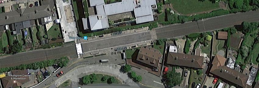
cut along the line of the existing Luas Green Line embankment and then onto a ramp structure to its
eventual tie-in point, north of Ranelagh Stop. The final operating configuration will result in the
severance of the existing Luas Green Line at Charlemont with future metro vehicles operating
exclusively south of the tie-in point in order to enable through metro services from Swords to Bride’s
Glen. Luas Green Line services will operate between Charlemont Stop and Broombridge Stop.

                               Figure 2: NMN tie-in point at Ranelagh

                                                                                        Page 10 of 72
EXISTING INFRASTRUCTURE
The types of metro operations under consideration for NMN will have a varying degree of impact on
the infrastructural changes required to upgrade the Luas Green Line to a metro standard. In addition,
the differing characteristics of Line B and Line B1 introduce both opportunities and challenges,
depending on the type of operations applied. Consequently, Line B and Line B1 are assessed
separately. The illustration in Figure 3 provides a context for the location of the tie-in point on the
Luas Green Line, and the two line sections that are the subject of this study. An overview of the
characteristics of each line section is provided in Sections 3.1 and 3.2.
Figure 3: NMN tie-in in context with Luas Green Line
3.1 Line B (Ranelagh to Sandyford)
Significant sections of Line B were constructed within the route of the old Harcourt railway line and as
a result, large sections are contained within the original railway cuttings. The infrastructure itself was
designed and constructed for possible later conversion to metro rail operations from Ranelagh to
Sandyford, including an increased track interaxis, increased separation distances from trackside
structures (to accommodate wider bodied trainsets), and additional space capacity within the
substations to allow for future power upgrades. The line runs within the old railway cutting and is
largely segregated from its surrounds, other than at three locations (Dunville Avenue / Beechwood
Road at Beechwood Stop, access to Alexandra College from Richmond Avenue South at Milltown Stop
and St. Raphaela’s Road at Stillorgan Stop) where there are at-grade crossings.
3.2 Line B1 (Sandyford to Bride’s Glen)
Line B1 from Sandyford to Bride’s Glen runs through a mixture of environments, from business parks
to housing estates to rural South Dublin. Passenger demand on this line section will increase in the
future due to the development of Cherrywood town centre, located adjacent to the current line
terminus at Bride’s Glen.
Unlike a majority of the Line B alignment, there are a number of sharp bends on the alignment, along
with significant interfaces with roads, residential areas, and a future town centre as previously stated.
Line B1 has a far higher level of at-grade running at locations such as Blackthorn Avenue, Ballyogan
Road and between Carrickmines and Cherrywood stations.
Page 11 of 72METRO OPERATING SCENARIOS
With the connection of NMN to the Luas Green Line at Ranelagh, interoperability between the two
systems is a necessity. Evaluating the engineering and cost impacts of upgrading the Luas Green Line
to achieve a seamless metro operation from Swords to Bride’s Glen requires details on the type of
metro operations proposed on NMN.
At the time of compiling this report, an Alignment Options Study to deliver an emerging preferred
route and a concept design of the same is underway. As the preferred route for NMN has not yet been
established, the level of segregation for the new line cannot be defined and as such, a decision on the
type of metro operations or vehicle type cannot yet be made. Therefore, both low floor vehicles (LFVs)
similar to the current Luas fleet and high floor vehicles (HFVs) similar to those found on international
metros (e.g. Copenhagen) require consideration in this study. In addition, without a decision on the
type of vehicle to operate on NMN, the operational characteristics (driver-controlled vs fully
automatic) are similarly undefined.
The length of the vehicles that will operate on NMN and MS is at present unknown and will be decided
upon once the required demand and capacity analysis has been completed. For the purpose of this
study, it is assumed that vehicles will be initially 60m long and that the line may eventually require
90m long vehicles to allow for future capacity increases.
In order to assess the infrastructure and cost impacts on the Luas Green Line of upgrading to a metro
standard, where that standard has not yet been defined, three separate operating scenarios will be
used to cover the potential options open for NMN.
4.1 Scenario 1: 60m LFV – Driver Controlled
Scenario 1 envisages NMN will operate similar to the current Luas system with driver-controlled LFVs.
Vehicles sets are 2.65m wide,1 low floor and 60m long, operating at a peak of 30 trains per hour (TPH).
For this level of service, segregation of all road junctions along the route is required and is considered
as part of this scenario.
Using passenger capacity figures received from vehicle manufacturers as part of the TII NMN Vehicle
Configuration study, a sample 2.65m wide, 64m long low-floor vehicle has a capacity of approx. 440
passengers (at 4 passengers per m2). Adjusted for 60m, this figure reduces to 413 and at 30 TPH, this
provides an estimated system capacity of 12,390 passengers per direction per hour (PPDPH).
4.2 Scenario 2: 60m HFV – Fully Automatic
Scenario 2 envisages NMN operating as a fully automatic metro system, similar to the Copenhagen,
Barcelona or Brescia metro systems. Vehicles are 2.65m wide, high floor and 60m long and the system
can operate at a peak of 40 TPH. For this level of service, segregation of all road junctions along the
route is required and is considered as part of this scenario.
1
Existing Luas fleet is 2.4m wide
Page 12 of 72Using the Copenhagen trainsets as an example, a 60m cabinless vehicle has a capacity of approx. 450
passengers (at 4 passengers per m2). At 40 TPH, this provides an estimated system capacity of 18,000
PPDPH.
4.3 Scenario 3: 90m LFV – Driver Controlled
Scenario 3 envisages that NMN will operate similar to the current Luas system with driver-controlled
vehicles. Train sets are 2.65m wide, low floor and 90m long (which would represent the maximum
extension length), operating at a peak of 30 TPH. For this level of service, segregation of all road
junctions along the route is required and is considered as part of this scenario.
Using passenger capacity figures as derived for the original Metro North project by Jacobs, a 2.4m
wide, 90m long low-floor vehicle has a capacity of approx. 674 passengers (at 4 passengers per m2). A
change in vehicle width to 2.65m was estimated to provide an increase in capacity of approx. 10.4%,
resulting in a figure of 744 passengers. At 30 TPH, this provides an estimated system capacity of 22,320
PPDPH.
INFRASTRUCTURE ASSESSMENT
The infrastructure impact assessment has been carried out in two stages. Stage 1 considers an upgrade
to metro services for Line B (Ranelagh to Sandyford), whilst stage 2 builds on this work and provides
an assessment of Line B1 (Sandyford to Bride’s Glen). In carrying out the assessments, the following
high-level assumptions have been made:
Metro services operate exclusively from Swords to Sandyford and Bride’s Glen;
New stop furniture assumed for all metro scenarios;
No safety or evacuation issues associated with reduced platform widths arising from the
installation of platform screen doors and platform end gates;
Green Line Capacity Enhancement (GLCE) works are complete and all existing platforms have
been lengthened to 53m;
Priority given to minimise the amount of works, limiting extensions over horizontal or vertical
track curvature, limiting impact on existing features (e.g. manholes or ducts, roads, walls,
retaining structures in general); and
Sandyford Depot to be upgraded to suit (where required).
5.1 Line B (Ranelagh to Sandyford)/Segregation
The existing Luas Green Line is limited to running a maximum of 24 TPH. This limitation is driven by
the non-segregated nature of the line and in particular the need for vehicles to stop at at-grade
crossings at Dunville Avenue and St Raphaela’s Road.
Page 13 of 72In order to achieve the increased frequency of services to 30/40 TPH required for Scenarios 1, 2 and
3, it will be necessary to completely segregate the line from any interface with road and pedestrian
traffic. This will involve taking steps to remove the at-grade crossings and, in addition, closing an
existing signalised junction at the access to Alexandra College.
Figure 4 shows a street view of Dunville Avenue, which is located just north of Beechwood Luas Stop.
To achieve segregation, it will necessary to permanently close this junction to all traffic.
Figure 4: Dunville Avenue
Figure 5 shows the signalised junction at the access to Alexandra College. This junction provides
pedestrian and vehicular access to the college. Luas currently has priority at this junction; however, in
order to achieve full segregated running, it will be necessary to close this junction and provide an
alternative access from Milltown Road to the college.
Page 14 of 72Figure 5: Access to Alexandra College
Figure 6 shows the existing signalised junction at St Raphael’s road, which is located just north of
Stillorgan Luas Stop. This is a much larger junction and an important connection between Sandyford
Industrial Park and Stillorgan Village.
Figure 6: St Raphaela’s Road junction with Luas at Stillorgan
As this road cannot be permanently closed, grade separation would be required to achieve
segregation for the upgraded metro line. There is insufficient distance between the track and
Blackthorn Avenue (which runs in parallel) to create an underpass beneath the rail or alternatively
elevate the road above. As a result, a bridge structure is proposed to raise the track above the road at
this location and therefore, Stillorgan Luas Stop would be positioned on the elevated structure
(approx. 4.8m above the current level of the platform). Figure 7 illustrates the proposed structure in
section and the extent of the structure compared to the current alignment in plan.
Page 15 of 72Figure 7: Proposed overpass and elevated stop at Stillorgan
To ensure service continuity for Luas Green Line services while the elevated structure is being
constructed, it is proposed that a temporary track is installed through the current Park & Ride,
bypassing the Stillorgan Luas Stop. This arrangement is illustrated in Figure 8. It would also be possible
to construct a temporary stop in this location if deemed necessary.
Figure 8: Proposed temporary track for maintaining Luas operations during bridge construction
5.1.1 Green Line Power & Systems (P&S) Upgrade
With the completion of the Luas Green Line Infrastructure Upgrade (GLIU), the existing traction power
system is being upgraded to accommodate the additional weight of the longer (54.7m) vehicles and
to provide sufficient capacity for an expected maximum frequency of 24 TPH.
The Luas Green Line substation structures were designed to be “metro upgradable”, with the space
capacity to accommodate either additional or physically larger traction power equipment. As such, no
structural modifications of the existing substation buildings would be required for the proposed
upgrade to metro services as described in Scenarios 1, 2 and 3. Additional equipment requirements at
Page 16 of 72Milltown, Dundrum, Balally and Sandyford substations (traction transformers and switch gear) to
deliver the extra power required for metro operations make up the majority of the P&S costs.
For the purposes of this report, it is assumed that each scenario will require an upgrade of the power
system, with Scenarios 2 and 3 demanding a more significant traction power upgrade than Scenario
1.
5.1.2 Signalling Upgrade
The current Luas system on the Green Line operates using “line of sight”, where the driver is
responsible for ensuring a safe distance from the vehicle in front is maintained. For the purpose of this
study, each metro scenario assumes a full signalling system is installed to provide for increased safety
with high service frequencies between stops. This would involve additional signalling equipment both
within the track area and within the technical rooms along the line.
5.1.3 Line Segregation Works
In addition to signalling, the line must be secured against trespass and passengers and other members
of the public prevented or actively discouraged from encroaching on the tracks. This would require
additional fencing to be installed along the alignment where such fencing is not yet in place or the
replacement of existing fencing with a more secure design. For Scenarios 1 and 3, additional fencing
is provided for within the cost of upgrading the stops. For Scenario 2, as it would be a fully automatic
line, additional costs for barriers to ensure the line is fully segregated are included in Section 5.
5.2 Luas Stop/Platform Modifications
The implementation of all three proposed metro operating scenarios will require significant upgrades
and modifications to all of the existing Luas platforms. The following sections detail the type and
nature of the modifications that will be required.
5.2.1 Scenario 1: 60m LFV – Driver Controlled
The physical characteristics of the low floor metro vehicles operating in this scenario are 60m in length
and 2.65m in width. As such, while platform heights would not require modification, an extension of
7m and trimming back of the edges would be required for each platform. For the majority of stops
within the study area, a high-level analysis did not reveal any major impacts for extending the
platforms to 60m length, with the level of work required comparable to the current GLIU project.
To allow the operation of larger vehicles (2.65m) through the existing stops, all existing platforms will
have to be trimmed (including the ramps on the non-extended side), thereby setting the coping edge
back by approx. 150mm as illustrated in Figure 9. This dimension would depend on type of rolling stock
and dynamic kinetic envelope (DKE), along with the body shape at the door thresholds.
To facilitate the platform trimming works, each stop undergoing upgrading works would require
closure for service but could reopen to standard Luas operations with the adoption of a platform-to-
tram platform filler (subject to further investigation). This filler would be in use for the time between
platform works and full NMN tie-in works. The fillers would be removed once the wider metro vehicles
are put in service. The scenario is more complicated where a chamber is located within the zone of
Page 17 of 72the tactile paving or where the platform structure is combined with a bridge deck structure (such as
Ranelagh). In the latter situation, additional time would be required to re-instate reinforcement
between the bridge deck and the remaining part of the platform slab. Table 1 provides a high-level
summary.
Figure 9: Approx. platform edge area to be removed and photo of platform edge
Land
Stop Name Construction Main Impacts
Take
RANELAGH EASY NO Equivalent to GLIU works scope
BEECHWOOD EASY NO Equivalent to GLIU works scope
COWPER EASY NO Equivalent to GLIU works scope
MILLTOWN EASY NO Equivalent to GLIU works scope
WINDY ARBOUR EASY NO Equivalent to GLIU works scope
DUNDRUM EASY NO Equivalent to GLIU works scope
BALALLY EASY NO Equivalent to GLIU works scope
KILMACUD EASY NO Equivalent to GLIU works scope
STILLORGAN EASY NO Non-segregated- Equivalent to GLIU works scope
SANDYFORD EASY NO Equivalent to GLIU works scope
Page 18 of 72Table 1: Line B Study Area - Scenario 1 Summary
5.2.2 Scenario 2: 60m HFV – Fully Automatic
The physical characteristics of the high floor metro vehicles operating in this scenario are 60m in
length, 2.65m in width and with an internal floor height of approx. 915mm from the top of rail (TOR).
As a result, the height of the platforms would increase by approx. 630mm over the existing platform
levels and the length of the platforms would extend by an additional 7m. As the platform end ramps
would no longer be required, these would form part of the extension (while those not included within
the new platform area would be demolished).
In addition, the vehicles operating in this scenario are fully automated with no driver supervision and
as such, maintaining safety at the platforms is paramount. To ensure passengers do not enter the track
area (either accidently through falls or trips or deliberately through trespassing), Platform Safety Gates
(PSGs) with an approx. height of 1,500mm would be required at each platform edge, with the vehicle
doors fully aligned with the gates when stopped at the platforms and both sets of doors opening and
closing in sync. A cross-section through a typical platform is illustrated in Figure 10. Figure 11 shows
an over-ground platform on Copenhagen’s metro system before and after the installation of PSGs. Full
enclosure of the platform boundary would be achieved via barriers installed at the platform ends in
addition to removal of the ramps and the existing pedestrian crossings between each side.
Figure 10: Cross-section through typical upgraded stop (Scenario 2)
Page 19 of 72Figure 11: High-floor Copenhagen metro - before and after installation of PSGs
As passengers could no longer cross over to the opposite platform at track level, access arrangements
to either platform would require significant reconfiguration, including the addition of footbridges and
lifts (or modification of the same where already existing) at each stop. Figure 12 illustrates a standard
platform detail with a footbridge and lift access, and fully enclosed platform edges with access gates.
Figure 12: Typical arrangement at upgraded stop (Scenario 2)
This standard arrangement of footbridge and lifts was applied to each stop separately and modified
to suit the local conditions. It was concluded that while raising the platform level by over 600mm and
providing access to each platform without passengers crossing the track area is technically feasible
(while requiring significant works) for all stops within the Line B study area, the works at Ranelagh,
Dundrum, Stillorgan and Sandyford would prove challenging for differing reasons outlined in the
following paragraphs.
At Ranelagh, as the stop is located on a bridge structure, the increase in height of the platform,
surrounding balustrade and the lift structure would potentially result in a negative visual impact and
additional strengthening of the bridge structure would be required. Landtake of approx. 125m 2 would
be necessary to provide space for a new lift and stairs on the south-west of the bridge to access the
inbound platform along with adjustments to the stair and lift heights on the outbound side (see Figure
13)
Page 20 of 72Figure 13: Ranelagh Stop following upgrade (Scenario 2)
At Dundrum Luas Stop, the existing staircase access from the Main Street side would require
significant alterations to reach the raised platform height, in addition to a new lift (refer to Figure 14).
On the Taney Drive side, additional steps would be required to access the raised platform, while a new
lift would be required, serving the platform, the Taney Drive footpath and the underpass with a new
beneath-ground landing required. Additional impacts of these works include the existing lift and the
access bridge on the north side of the platform becoming redundant and a negative visual impact on
the Dundrum Station House protected structure because of raising the platform height in front.
Figure 14: Dundrum Stop following upgrade (Scenario 2)
The Stillorgan Luas Stop would be relocated to the bridge structure crossing over the Kilmacud Upper
Extension Road (refer to Section 4.2.1 for more detail). At Sandyford, maintaining access to the lateral
and island platforms would require two significant footbridge structure and three lifts (as illustrated
Page 21 of 72in Figure 15). Additional fencing would be required along the inbound track to prevent access to the
track area and this would continue either side of the track area along Blackthorn Avenue.
Figure 15: Sandyford Stop following upgrade (Scenario 2)
A full set of drawings showing the extent of work proposed at each stop under this scenario is included
in Appendix 3. Table 2 provides a high-level summary.
Land
Stop Name Construction Main Impacts
Take
Visual impact on bridge with rise in platform height, bridge
RANELAGH DIFFICULT YES strengthening required. Additional access on inbound side
requiring landtake.
Closure of Dunville Avenue, north of stop – pedestrians to
BEECHWOOD MEDIUM NO
use stop stair/lift and footbridge for access.
Crossing south of stop closed – pedestrians to use stairs/lift
COWPER MEDIUM NO
and footbridge for access.
Both vehicular and pedestrian access to Alexandra College
MILLTOWN MEDIUM YES from Richmond Avenue South is closed – pedestrians to use
stop stair/lift and footbridge for access.
Crossing on north of stop closed for through foot traffic –
WINDY ARBOUR MEDIUM NO
pedestrians to use stop stair/lift and footbridge for access.
Strengthening of existing stone retaining wall on inbound
side required. Below ground works required for lift access
DUNDRUM DIFFICULT NO
from underpass to street and platform level. Visual impact
on Dundrum Station House.
Requires opening in bridge parapet for new lift access on
BALALLY EASY NO
outbound side. Existing access from retail unit maintained.
Page 22 of 72Land
Stop Name Construction Main Impacts
Take
Existing access arrangements maintained with additional
KILMACUD MEDIUM NO
stair and lift access created on inbound side.
Stop located on new overpass for grade separation of track
STILLORGAN DIFFICULT NO with Upper Kilmacud Road Extension. Temporary track
installation through existing Park & Ride.
Outbound side stone wall requires strengthening. One set
SANDYFORD DIFFICULT NO of additional stairs and lift required for access to island
platform.
Table 2: Line B Study Area - Scenario 2 Summary
5.2.3 Scenario 3: 90m LFV – Driver Controlled
The platform lengths on the Luas Green Line, following the GLIU works, will be 53m, requiring an
additional 37m to accommodate a 90m light rail vehicle as used within this scenario. Following an
internal TII engineering assessment, it was concluded that while platform extensions to 90m are
technically feasible for all stops within the Line B study area, the extension of Ranelagh, Cowper,
Windy Arbour and Sandyford would prove challenging for differing reasons outlined in the following
paragraphs.
To ensure sufficient space is provided to facilitate the nearby NMN tie-in, the Ranelagh platform would
require extension towards the Sandyford direction. Consequently, there would be a significant impact
on the existing passenger access buildings (refer to Figure 16) located at the southern end of the
platforms. The existing stairwell and platform level structure on the outbound side would be
demolished while the lift shaft would be retained within a new building. The existing pedestrian
underpass would also be retained and extended to provide passenger access to a new staircase and
lift to the platform level. The current stairwell structure on the inbound side would be demolished and
a new structure provided, set back from the structure, to provide space for the platform. This would
require landtake within the green area below the stop.
Figure 16: Ranelagh passenger access
Page 23 of 72At Cowper Luas Stop, the preferred extension side would be northwards, requiring the taking of
approx. 2.5m of nine back gardens on the inbound side. However, the gardens in question are already
limited in space and removal of a 2.5m strip would remove a significant proportion of the land
available to the occupants. For the purpose of this report, the platform is extended south instead, with
the key drawback that the pedestrian passage across the tracks would no longer be combined with
the stop pedestrian crossing. This could increase the risk of uncontrolled pedestrian crossing in the
middle of the platforms and introducing approx. 80m walking detour through the platforms for prams
and wheelchair users. This could also potentially add unnecessary congestion to the platforms (refer
to Figure 17).
Figure 17: Cowper pedestrian passage/crossing
For Windy Arbour Luas Stop, the opposite approach to Cowper is proposed, in that 1.8m of seven
relatively large back gardens would be taken to extend the platform southwards in order to maintain
the pedestrian route across the northern end of the current stop. Extending northwards would
introduce a convoluted pedestrian detour of approx. 80m, and would unnecessarily overload the
platforms with pedestrian traffic and increase risk due to pedestrians directly crossing via the two
platforms.
Sandyford Luas Stop could only be extended northwards due to complex trackworks and geometries
on the south side to allow for the links to Line B1 and the entrance to the depot. The stop is currently
designed to cater for a mixed service of passing trams (Bride’s Glen to St. Stephen’s Green) and
turning-back trams (St. Stephen’s Green to Sandyford), plus the necessary connections in and out of
the depot. For this reason, the stop has three tracks with three platform sides (one lateral and one
island) and a series of crossovers plus a simple junction. One consequence of extending the platforms
north would be the requirement to relocate one crossover and one turnout further north (refer to
Figure 18).
Page 24 of 72Figure 18: Sandyford Stop extension
Further technical information on each stop is contained within Appendix 1 and Table 3 provides a high-
level summary. In addition to the platform extension works and the associated measures required,
the track facing edge of each platform would require trimming, as described in Section 4.2.2.1.
An upgrade to Line B (Ranelagh to Sandyford) in isolation of an upgrade to Line B1 (Sandyford to
Bride’s Glen) would result in the termination of metro service at Sandyford (thereby retaining a Luas
service from Sandyford to Bride’s Glen). In this scenario, a number of factors would require
consideration as described in the following section.
Land
Stop Name Construction Main Impacts
Take
Stairwell buildings on inbound and outbound side to be
demolished, outbound lift retained with new stairs, with
RANELAGH DIFFICULT YES
new lift and stairs on inbound side requiring landtake and
new access way from Ranelagh Road.
BEECHWOOD EASY NO Equivalent to GLIU works scope
Crossing centre of stop closed - pedestrians to use crossing
COWPER MEDIUM NO
at platform for access.
MILLTOWN EASY NO Equivalent to GLIU works scope
Page 25 of 72Land
Stop Name Construction Main Impacts
Take
Landtake of 7 No. properties back gardens on the inbound
WINDY ARBOUR MEDIUM YES southern side of the platform.
DUNDRUM MEDIUM NO No major impacts
BALALLY MEDIUM NO No major impacts
KILMACUD MEDIUM NO No major impacts
Stop extension at ground level without overpass of road is
STILLORGAN EASY NO
straightforward. Refer to Scenario 2 for overpass.
Track work required to achieve northwards extension of
SANDYFORD MEDIUM NO
platforms.
Table 3: Line B Study Area - Scenario 3 Summary
5.3 Sandyford Depot Implications
This study provides a high-level cost assessment for the infrastructure modifications that would be
required to the Sandyford Depot if it were required to accommodate the stabling of metro trams and
be the termination point for metro services. In the event of a decision to terminate the metro service
at Sandyford (thereby retaining a Luas service from Sandyford to Bride’s Glen), a number of factors
would require further consideration as follows:
Interchange arrangements at Sandyford Stop: As Sandyford Stop would become a
service interchange between the metro and Luas, turn-back arrangements for both
metro and Luas would require further study to ensure headways can be maintained. In
addition, passenger access arrangements between the two services would also need
further study, especially in the event of an automated metro service due to the level of
segregation involved.
The operational status of Sandyford Depot: In such a scenario, the depot would either
be used solely for metro stabling and maintenance (a new depot would be required to
support Line B1 operations) or be retained for Luas vehicles only, requiring other
arrangements for stabling of metro vehicles for start of service in the mornings and
significant track work to create a new entry. Mixed occupation of the depot by both
metro and Luas vehicles would result in significant technical and contractual risk and
Page 26 of 72consequently is unlikely to be considered further. Expansion of the depot is not possible
as the site occupies the maximum possible footprint.
Line B1 isolation from Luas Cross City (LCC)/Line C: With a metro system operating to
Sandyford, Line B1 (and a future Line B2 to Bray) would become isolated from the
remainder of the Luas system. In order to facilitate the transfer of trams between
LCC/Line C and Line B1, either an engineering link would be provided between the
Charlemont terminus and the upgraded metro line, or all vehicle transfers would be
carried out using the road network. In the engineering link scenario, this would also
require a significant level of interoperability between the metro system running on the
former Line B and the Luas vehicles.
The costs estimates provided as part of this report for the Sandyford Depot modifications do not
currently account for these factors.
5.3.1 Sandyford Depot Modifications - Scenario 1: 60m LFV – Driver Controlled
Following completion of the GLCE works, Sandyford depot will have an ultimate capacity of 30 no.
54.7m long vehicles. Following initial analysis, it has been determined that approx. 26 trams of 60m
length can be stabled within the depot using this new configuration (as illustrated in Figure 19).
Space proofing the 60m vehicles within the maintenance shed would require a more detailed analysis
to check against the position of objects such as the pits, gantries, doors, etc. but vehicles of this length
would appear to fit within the extended depot building without additional major works required.
Figure 19: Sandyford Depot capacity and modifications for 60m metro vehicles
Page 27 of 725.3.2 Sandyford Depot Modifications - Scenario 2: 60m HFV – Fully Automatic
As discussed in Section 5.3.1, initial analysis concludes that up to 26 60m long vehicles could be stabled
within the depot (following the current capacity enhancement works) with minimal works required.
Further detailed analysis would be required to establish the impact of automated HFVs operating
within the depot environment.
5.3.3 Sandyford Depot Modifications - Scenario 3: 90m LFV – Driver Controlled
Figure 20 illustrates the Sandyford Depot following the GLCE works completion with 90m long vehicles
superimposed in the stabling area and in the maintenance shed (outlined in blue). Following the GLCE
works, the maximum stabling capacity for 53m long Luas vehicles will be 26; with a 90m metro vehicle,
this figure would drop to 16. Maintenance capacity would be similarly affected; each maintenance
track within the shed (as illustrated in Figure 20) could accommodate one vehicle at a time, rather
than two.
The sanding plant (top left in the maintenance shed) would require extending as shown hatched in
Figure 20, while there would be no impact on the washing plant (top right in the shed) as this is a pass-
through system. In addition, a new track extension would be required outside the lower left corner of
the maintenance shed (opening a door through the building) to allow wheel-turning activities in the
middle of the shed.
The two stabling tracks in the loop and the single dead-end track in the delivery lane (top right in the
sketch), both built as part of the GLCE project, would become redundant, as would the use of the two
north apron tracks (on the left of the maintenance shed). Some of them could be re-used for
maintenance vehicle parking, while the two large areas on either end of the maintenance shed built
as extensions for GLCE project in 2017 would become redundant.
The most critical aspect is operational; a vehicle coming off the line and waiting to be sanded would
foul the rest of the entrance fan to the depot, blocking most of the other movements in and out.
Figure 20: Sandyford Depot capacity and modifications for 90m metro vehicles
Page 28 of 72COST IMPACT ESTIMATE LINE B (RANELAGH TO SANDYFORD)
This section includes the cost estimates produced for each operating scenario for upgrading Ranelagh
to Sandyford to metro standard, following the engineering analysis. The costings described in this
section are indicative, and additional design development and analysis would be required to provide
upgrade costs with a greater level of confidence, once the final operating scenario has been chosen
for NMN.
6.1 Scenario 1: 60m LFV – Driver Controlled
Table 4: Assumptions and Exclusions for Costing Scenario 1
Scenario 1 - Assumptions and Exclusions
1 All Stops
Rates for platform extension works, track infill panel works, stop furniture and removal and
1.1 reinstatement of existing platform surfaces have been obtained from GLIU - Platform
Extensions Pricing Document.
1.2 A nominal amount of 30% has been allowed for Preliminaries.
It has been assumed that 1 No. Automatic Vehicle Location System (AVLS) loop will be
1.3 required at the end of the new extension.
It has been assumed that 2 No. Validators will be required at each new platform extension (4
1.4 No. per stop).
1.5 The rate for trimming of the platform edge has been generated from current market rates.
1.6 Only new balustrading required for the platform extension has been included.
2 Ranelagh
Nominal amounts have been allowed for Demolition and Alterations, Property Acquisition
2.1 based on previous contracts.
2.2 The rate for the lift works has been obtained from building costs undertaken by Linesight.
4 Sandyford
The island platform rates have been generated from GLIU Contract - Harcourt platform
4.2 extension.
5 Depot
The estimated costs for upgrading the depot to suit each scenario will be included within the
Line B1 study area costings.
Page 29 of 72Table 5: Cost Estimate Breakdown – Scenario 1
Scenario 1 Scenario 1
60m Low Floor 60m Low Floor
Item Description
Unsegregated Junction Segregated Junction
1 Ranelagh Stop € 899,291.63 € 899,291.63
2 Beechwood Stop € 723,600.63 € 743,100.63
3 Cowper Stop € 531,909.92 € 531,909.92
4 Milltown Stop € 697,815.97 € 697,815.97
5 Windy Arbour Stop € 820,965.21 € 820,965.21
6 Dundrum Stop € 748,614.42 € 748,614.42
7 Balally Stop € 767,014.45 € 767,014.45
8 Kilmacud Stop € 733,523.89 € 733,523.89
9 Stillorgan Stop € 679,558.33 € 11,365,775.00
10 Sandyford Stop € 860,708.39 € 860,708.39
11 Power & Systems € 8,000,000.00 € 8,000,000.00
Total € 15,463,002.85 € 26,168,719.52
12 Design - 7.5% € 1,159,725.21 € 1,962,653.96
13 Project Management - 14.5% € 2,242,135.41 € 3,794,464.33
14 TII Insurance and Overheads - 3% € 463,890.09 € 785,061.59
15 Transdev Interface Costs @ 6% € 927,780.17 € 1,570,123.17
Construction Risk and Order of
16 Magnitude € 5,064,133.43 € 8,570,255.64
17 Inflation to 2022 @ 2.5% € 3,300,000.00 € 5,500,000.00
Total € 28,620,667.17 € 48,351,278.21
Difference € 19,730,611.05
Page 30 of 726.2 Scenario 2: 60m HFV – Fully Automatic
Table 6: Assumptions and Exclusions for Costing Scenario 2
Scenario 2 - Assumptions and Exclusions
1 All Stops
1.1 The rates for Power & Systems works have been obtained from BXD_450 LCC Variation.
1.2 A nominal amount of 30% has been allowed for Preliminaries.
1.3 It has been assumed that no AVLS loops will be required.
1.4 The replacement of the stop furniture has been excluded as it is assumed that the stop
furniture will be replaced to match the NMN stop furniture/branding theme.
1.5 An assumption of €600,000 has been allowed for the platform screen gates - waiting on a
rate from a supplier.
1.6 Rates for platform extension works, platform-raising works, stop furniture and removal,
and reinstatement of existing platform surfaces have been obtained from GLIU - Platform
Extensions Pricing Document.
1.7 It has been assumed that €850,000 will be sufficient per stop for footbridges and lifts.
1.8 Platform raising works has a separate BOQ to provide clarity to the reader.
1.9 The demolition of the existing ramp at each stop - this rate was generated from GLIU
Platforms Contract.
1.10 It has been assumed that all material used in the reinstatement of existing platform
surfaces is new material and not being re-used.
1.11 It has been assumed that track-infill panels will not be required as the platform is now
screened.
2 Beechwood
It has been assumed that the café at Beechwood Stop is property of TII and no monetary
2.1 value has been included for Property Acquisition.
It has been assumed that the closure of Dunville Avenue will cause issues so a monetary
2.2 value has been added to the budget for this stop.
3 Milltown
Based on rates from GLIU platform extension, a rate of €600 has been applied for the
3.1 construction of approx. 19m long stone boundary wall and bulk earth removal.
It has been assumed that €25,000 will suffice for the Property Acquisition form Alexandra
3.2 College (area 1.3m x 1.8m).
4 Windy Arbour
A rate of €250 has been applied for re-grading the existing footpath - based on GLIU
4.1 rates. In addition, the area has been scaled off the drawings provided by TII.
7 Stillorgan
7.1 The overpass estimate was generated from Carrickmines Bridge, inflated to current prices.
Page 31 of 72Scenario 2 - Assumptions and Exclusions
8 Sandyford
8.1 The island platform rate has been generated from GLIU Platform extensions – Harcourt.
9 Depot
The estimated costs for upgrading the depot to suit each scenario will be included within
the Line B1 study area costings.
Table 7: Cost Estimate Breakdown – Scenario 2
Scenario 2
60m High Floor
Item Description
Segregated Junction
1 Ranelagh Stop € 3,982,549.83
2 Beechwood Stop € 3,262,531.69
3 Cowper Stop € 2,967,574.10
4 Milltown Stop € 3,339,085.15
5 Windy Arbour Stop € 3,270,102.51
6 Dundrum Stop € 2,364,373.94
7 Balally Stop € 2,280,318.31
8 Kilmacud Stop € 3,085,960.56
9 Stillorgan Stop € 12,145,775.00
10 Sandyford Stop € 4,588,785.44
11 Power & Systems € 31,291,250.00
Total € 72,578,306.53
12 Design - 7.5% € 5,443,372.99
13 Project Management - 14.5% € 10,523,854.45
14 TII Insurance and Overheads - 3% € 2,177,349.20
15 Transdev Interface Costs @ 6% € 4,354,698.39
Construction Risk and Order of
16 Magnitude € 23,769,395.39
17 Inflation to 2022 @ 2.5% € 15,200,000.00
Total € 134,046,976.94
Page 32 of 726.3 Scenario 3: 90m LFV – Driver Controlled
Table 8: Assumptions and Exclusions for Costing Scenario 2
Scenario 3 - Assumptions and Exclusions
1 All Stops
Rates for platform extension works, track infill panel works, stop furniture and removal, and
1.1 reinstatement of existing platform surfaces have been obtained from GLIU - Platform
Extensions Pricing Document.
1.2 A nominal amount of 30% has been allowed for Preliminaries.
1.3 It has been assumed that 1 No. AVLS loop will be required at the end of the new extension.
It has been assumed that 2 No. Validators will be required at each new platform extension (4
1.4 No. per stop).
1.5 The rate for trimming of the platform edge has been generated from current market rates.
1.6 Only new balustrading required for the platform extension has been included.
2 Ranelagh
Nominal amounts have been allowed for Demolition and Alterations, Property Acquisition
2.1 based on previous contracts.
2.2 The rate for the lift works has been obtained from building costs undertaken by Linesight.
3 Windy Arbour
Property Acquisition - it has been assumed that €30,000 per property will meet the
3.1 requirements from residents (7 No. properties).
4 Sandyford
It has been assumed that no Track Infill panels are required at Sandyford as the track will be
4.1 replaced due to the relocation of the specialist track equipment - crossover and turnout.
The island platform rates have been generated from GLIU Contract - Harcourt platform
4.2 extension.
5 Depot
The estimated costs for upgrading the depot to suit each scenario will be included within the
Line B1 study area costings.
Page 33 of 72You can also read