Newgatestreet Road Development Brief Draft for public consultation September 2020 - Borough ...
←
→
Page content transcription
If your browser does not render page correctly, please read the page content below
Newgatestreet Road
    Development Brief
Draft for public consultation

      September 2020

              1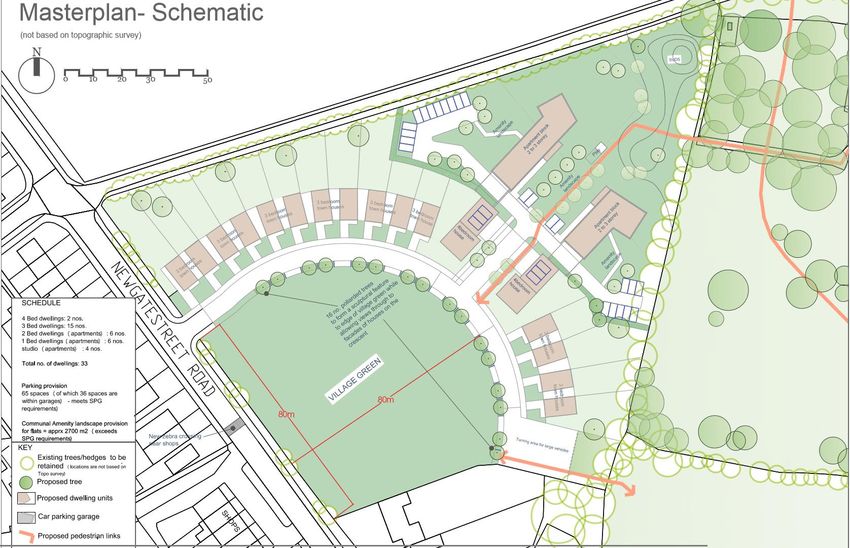
Newgatestreet Road Development Brief – draft for public consultation (September 2020)

Contents

Introduction ......................................................................................................................................... 3
Site Description .................................................................................................................................. 3
Broxbourne Local Plan ..................................................................................................................... 5
The Design Concept: Evolution and Continuity ........................................................................ 7
National Design Guide ...................................................................................................................... 8
Vision and Objectives ....................................................................................................................... 9
   Objective 1: Create a new communal green as a focal point for the village to achieve
   social interaction and enhanced character and identity for Goffs Oak......................... 10
   Objective 2: provide attractive, convenient, and safe access for all users .................. 11
   Objective 3: Enhance the natural environment and rural character .............................. 13
   Objective 4: high quality residential development to enhance the setting of the
   communal green........................................................................................................................... 15
Appendix A: Illustration of potential acceptable design solutions .................................... 18

                                                                           2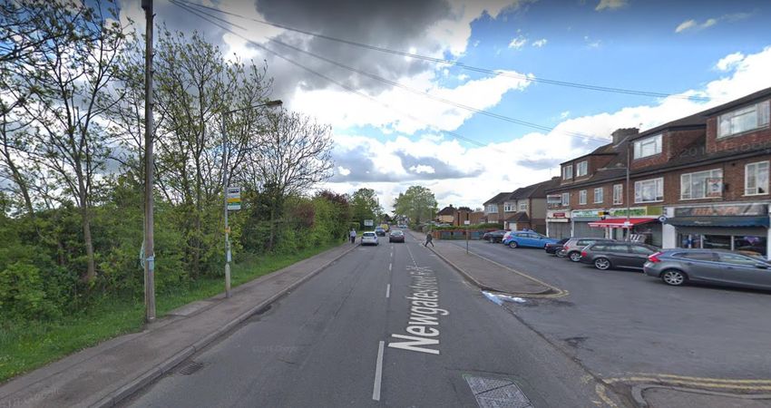
Newgatestreet Road Development Brief – draft for public consultation (September 2020)

Introduction
The site at Newgatestreet Road has been released from the Green Belt through the
new Broxbourne Local Plan in order to provide an enhanced identity for the village of
Goffs Oak through provision of a communal green in a prominent location near the
centre of the village. This design brief serves an important purpose in adding detail
to the Local Plan policy framework in terms of the design of development. In order
for planning applications to be approved, the Council expects the final design to have
appropriate regard to the vision and objectives set out in this document. An
illustrative design solution to achieve the vision and objectives is set out in Appendix
A.

Site Description
The site allocation comprises an open field of 2.28 hectares (5.07 acres) immediately
to the south west of Goffs Oak Village Centre. Its boundaries are defined by
Newgatestreet Road to the west and St James Road to the north west. Two
detached dwellings and Goff’s Oak public house on Wesley Court form the southern
boundary. The eastern boundary comprises open fields, a commercial yard and
sports fields. Directly opposite the site on the west side of Newgatestreet Road is
Mason’s Parade and
Goff’s Oak Methodist
Church.

The site boundaries are
well defined by existing
trees, hedgerow and
vegetation; the boundary
with Newgatestreet Road
has a good level of self-
seeded trees and a
hedgerow      along   its
length. The site is also
screened from St James
Road to the north by a          Figure 1: aerial photo showing Green Belt boundary
mature hedgerow.

The site slopes from the south west on Newgatestreet Road to the north east on St.
James Road. It has been in use for arable farming land until recently.

In terms of public transport services to the site, the 242 bus route travels along Goffs
Lane from Welwyn Garden City through to Waltham Cross via Goffs Oak. The
nearest rail station is Cuffley Station which is approximately 1.4km from Goffs Oak.

                                              3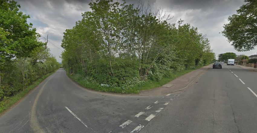
Newgatestreet Road Development Brief – draft for public consultation (September 2020)

Figure 2: Site Plan

                                              4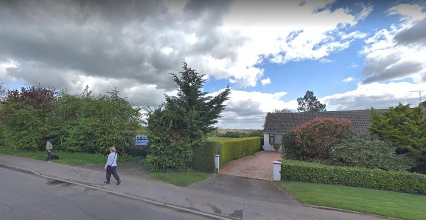
Newgatestreet Road Development Brief – draft for public consultation (September 2020)

Broxbourne Local Plan
The Broxbourne Local Plan 2018-2033 (adopted June 2020) allocates four greenfield
extensions to the village of Goffs Oak, as shown within the indicative Concept Plan
below. As shown above, the site was released from the Green Belt. The ‘exceptional
circumstances’ for release of the site from the Green Belt related to the provision of
the new open space indicated for play on the indicative Concept Plan below1.
Figure 3: Indicative Concept Plan for Goffs Oak (source: Broxbourne Local Plan)

The accompanying policy GO4: Newgatestreet Road was examined by the Local
Plan inspector, whose final report2 states at paragraph 180 that “Policy GO4
proposes 25 homes and a new area of public open space on land at Newgatestreet
Road, along with improved pedestrian links. Whilst the new homes would encroach
into the countryside, they would be close to the village centre and the proposal would
present the opportunity to create a village green in an appropriate location.”

1
    Green Belt Topic Paper, 2017
2
    Broxbourne Local Plan 2018-2033, Inspector’s Final Report (14 April 2020) www.broxbourne.gov.uk/localplan

                                                       5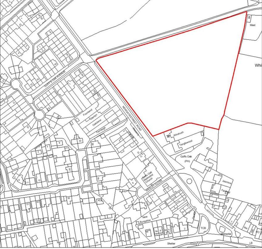
Newgatestreet Road Development Brief – draft for public consultation (September 2020)

Policy wording
Relevant extracts from the Local Plan Policy GO4 and supporting text are provided
in italics below.
Newgatestreet Road
8.6 The field at the junction of Newgatestreet Road and St James Road has been
promoted for housing development. A limited amount of housing is considered
appropriate in order to open up the field for community uses, linked to the existing
playing pitches behind the village centre. Land to the east of the identified area will
be retained as Green Belt in order to protect the important gap between Goffs Oak
village and St James'.

Policy GO4: Newgatestreet Road
The site identified on the Policies map is allocated for development as follows:
1. Approximately 25 homes;
2. 40% affordable housing
3. New public open space – minimum 0.8 hectares;
4. Pedestrian crossing on Newgatestreet Road;
5. Pedestrian links to the existing playing pitches.
A development brief will be prepared for this site.

Additionally, policy PM1 is considered of relevance to the design and layout of the
site, taking account of the available opportunities.
Sustainable Place-Making
4.3 This Local Plan proposes a number of new places. They will be connected to
existing towns and villages and need to respect those relationships. However, they
will also be places in their own right. This Plan establishes the framework where new
development can achieve sustainable new places but also puts in place policies that
seek to improve existing towns, villages and the countryside areas around them.

Policy PM1: Sustainable Place Making
New developments proposed within the Borough are required to complement
existing town and villages and the countryside around them. Major developments
must also establish their own identities through the implementation of sustainable
place making principles.

Finally, Policy DSC1: Design and Sustainable Construction states that ‘where-ever
possible, development proposals must…enhance local character and
distinctiveness...’

                                              6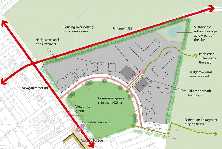
Newgatestreet Road Development Brief – draft for public consultation (September 2020)
The Design Concept: Evolution and Continuity
Goffs Oak contains an official registered ‘village green’ at Jones Road (see Concept
Plan above), but this is located around 600m from the village centre, and over 1km
from the northern areas of the village. The existing playing fields are located more
centrally but are concealed from Newgatestreet Road and Cuffley Hill/Goffs Lane.
The main objective of the site allocation is to create a new green that is both
centrally located and highly visible as a focal point, contributing to a strengthening of
the ‘village’ identity.
The indicative Concept Plan in the adopted Local Plan (Figure 3 above) indicates
vehicular access from both Newgatestreet Road and St James’ Road, with the open
space located to the north of this. However, in response to a recent planning
application, Hertfordshire County Council advised that a) vehicular access to St
James’ Road is not necessary for this scale of development and b) access from
Newgatestreet Road should be moved further north to avoid safety issues with
Mason’s Parade.
The Council has therefore proposed an alternative site layout as set out in Appendix
A: Illustration of a potential acceptable design solution. This proposal has a
number of advantages:
Strengthening visual connections and the pedestrian desire line between
Mason’s Parade and the communal green whilst avoiding safety conflicts;
Reducing the distance between the communal green and the village centre;
Maintaining the rural character of St James’ Road;
Providing better connections between the communal green and the existing
playing fields;
Retaining the openness of the environs of the existing dwelling known as
‘Windrush’.
7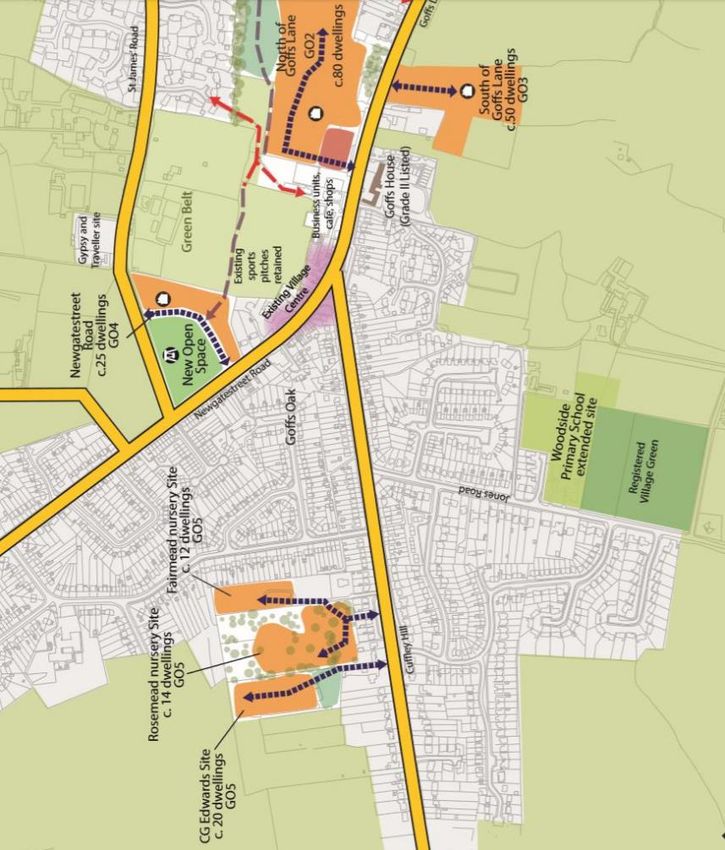
Newgatestreet Road Development Brief – draft for public consultation (September 2020)

National Design Guide
The National Design Guide3 sets out the 10 characteristics of well-designed places,
which are referenced within this development brief and which will be used to assess
proposals for the Newgatestreet Road site allocation, together with the Local Plan.

Context – enhances the surroundings
C1. Understand and relate well to the site, its local and wider context
C2. Value heritage, local history and culture
Identity – attractive and diistinctive
I1: Respond to existing local character and identity
I2. Well designed, high quality and distinctive
I3. Create character and identity
Built Form – a coherent pattern of development
B1. Compact form of development
B2. Appropriate building types and forms
B3. Destinations
Movement – accessible and easy to move around
M1. An integrated network of routes for all modes of transport
M2. A clear structure and hierarchy of connected streets
M3. Well considered parking, servicing and utilities infrastructure for all users
Nature – enhanced and optimised
N1. Provide high quality, green open spaces with a variety of landscapes and
activities, including play
N2. Improve and enhance water management
N3. Support rich and varied biodiversity
Public spaces – safe, social and inclusive
P1. Create well-located, high quality and attractive public spaces
P2. Provide well-designed spaces that are safe
P3. Make sure public spaces support social interaction
Uses – mixed and integrated
U1. A mix of uses
U2. A mix of home tenures, types and sizes
U3. Socially inclusive
Homes & Buildings – functional, healthy and sustainable
H1. Healthy, comfortable and safe internal and external environment
H2. Well-related to external amenity and public spaces
H3. Attention to detail: storage, waste, services and utilities
Resources – efficient and resilient
R1. Follow the energy hierarchy
R2. Selection of materials and construction techniques
R3. Maximise resilience
Lifespan – made to last
L1. Well-managed and maintained
L2. Adaptable to changing needs and evolving technologies
L3. A sense of ownership

3
    MHCLG, October 2019: https://www.gov.uk/government/publications/national-design-guide

                                                    8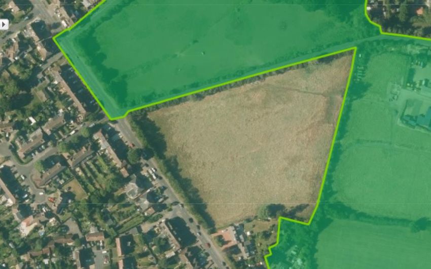
Newgatestreet Road Development Brief – draft for public consultation (September 2020)

Vision and Objectives
Four design objectives have been developed for the Newgatestreet Road site. These
are informed by an overarching vision for the site to which the eventual design will be
expected to aspire:

Development of the Newgatestreet Road site allocation will create a new communal
green, providing a community function as a meeting point near the centre of the
village, and including space for community events as well as play and recreation.
The green will have a prominent role in the life of the village, will be highly visible
from Newgatestreet Road, and will be overlooked by attractive residential properties
of exemplary design quality. This will be a place to strengthen the identity of the
village, enhancing its rural character, and of which both new and existing residents
can be proud.

Figure 4 below shows how the key requirements of this Brief may be illustrated
spatially. Development areas are shown in grey. Individual buildings are represented
by dotted grey lines for illustrative purposes only.
Figure 4: Diagram illustrating the vision and objectives set out in this Brief.

Explanation of the four objectives for the site is provided below.

                                              9
Newgatestreet Road Development Brief – draft for public consultation (September 2020)
Objective 1: Create a new communal green as a focal point for the village to
achieve social interaction and enhanced character and identity for Goffs Oak.
This objective reflects the following National Design Guide characteristics of well-
designed spaces:
P1. Create well-located, high quality and attractive public spaces
P2. Create well-designed spaces that are safe
P3. Make sure public spaces support social interaction
N1. Provide high quality, green open spaces with a variety of landscapes and
activities, including play
I1. Respond to existing local character and identity
I2. Well-designed, high quality and distinctive
I3. Create character and identity
L1: Well managed and maintained
L3. A sense of ownership
As set out on page 7 above, the original design concept set out in the Local Plan has
evolved in response to Hertfordshire County Council’s comments regarding vehicular
access to the site, but the core vision remains that set out in the Local Plan of “a
limited amount of housing…in order to open up the field for community uses”.
How much open space?
The Local Plan indicates the need for a minimum of 0.8 hectares open space for
such purposes. This size of open space is considered the minimum necessary to
enable the creation of a communal green for the local community to come together,
for example hosting community events and activities in a prominent location well
related to the village centre (N1). Any land required for the provision of other open
space, for example sustainable drainage features, would require additional land and
should not be deducted from the total needed to create a communal green.
Form and layout of the communal green
In order to maximise its contribution to creating local character and identify (I3) as
well as ensuring that it supports social interaction (P3), the communal green should
maximise frontage to and visibility from Newgatestreet Road and Mason’s Parade.
The Council will not adopt open space within the development and therefore
proposals for development within site GO4 should include provision for appropriate
management arrangements in perpetuity (L1).
Reflecting its importance to the local community, the form and layout of the
communal green should be planned in consultation with local residents (L3). Subject
to the outcomes of public engagement, it is anticipated that the communal green will
at minimum include facilities for informal play (such as informal cricket and football)
in a safe location visible from Newgatestreet Road and overlooked by residential
development. A limited amount of on-street parking should be provided for users of
the green.
10Newgatestreet Road Development Brief – draft for public consultation (September 2020)
Objective 2: provide attractive, convenient, and safe access for all users
This objective reflects the following National Design Guide characteristics of well-
designed spaces:
M1. An integrated network of routes for all modes of transport
M2. A clear structure and hierarchy of connected streets
B3. Destinations
Vehicular access
The choice of access location should reflect the requirement to provide a communal
green consistent with the Local Plan and vision and objectives within this Brief. As
explained on page 7 above in relation to the evolution and continuity of the design
concept, for safety reasons vehicular access should also avoid Mason’s Parade.
As set out in this Brief, residential development will play an important role in
overlooking the communal green. This presents an opportunity for the access road to
the properties to provide definition and attractive street scene (M2). The opportunity
existing for a secondary internal street leading off this main street to provide
additional housing to the rear.
Proposals should also include an appropriate turning head for refuse collection
trucks or other large vehicles as necessary (H3). The Council’s Waste
Supplementary Planning Guidance and Roads in Hertfordshire should be consulted
for further information and requirements. As shown in the illustrative design solution
at Appendix A, this proposal could also provide a visual connection through to the
existing playing fields.
Access for pedestrians and cyclists
The communal green will be a destination for community events. It is therefore
essential that access to the green should be suitable for all age ranges.
The Local Plan requires provision of a pedestrian crossing on Newgatestreet Road.
The purpose of this is to enable residents of the new development to access
Mason’s Parade, the bus stop and the existing settlement beyond, and also to
enable residents of the existing residential areas to access the communal green. The
preferred alignment of such a crossing is indicated in Figure 3 above and on the
illustrative design solution in Appendix A. View 1 below shows the desire line across
the road from Mason’s Parade (right) to the site of the new green (left, behind the
hedgerow).
11Newgatestreet Road Development Brief – draft for public consultation (September 2020)
View 1: South-east along Newgatestreet Road with the Site on the left and Mason’s
Parade on the right (source: Google streetview).
The Local Plan states at paragraph 8.6 that “a limited amount of housing is
considered appropriate in order to open up the field for community uses, linked to the
existing playing pitches behind the village centre.” Visual as well as physical
linkages between the existing pitches and the new communal green should be
provided. The illustrative design solution at Appendix A demonstrates how the
proximity and inter-visibility between the two spaces could be maximised through
effective layout of residential dwellings and open space.
12Newgatestreet Road Development Brief – draft for public consultation (September 2020)
Objective 3: Enhance the natural environment and rural character
This objective reflects the following National Design Guide characteristics of well-
designed spaces:
C1. understand and relate well to the site, its local and wider context
I1. respond to existing local character and identity
I2. well-designed, high quality and attractive
N1. provide high quality, green open spaces with a variety of landscapes and
activities, including play
N2. Improve and enhance water management
N3. Support rich and varied biodiversity
The village of Goffs Oak is characterised by a setting within the rolling hills and fields
of the Hertfordshire countryside. The immediate environs of the site include the rural
lane of St James’ Road, flanked on both sides by trees and hedgerows.
Development proposals should retain the trees and hedgerows along St James’
Road in order to retain the character of the lane and the rural character of this
gateway to Goffs Oak, and which may also serve to screen the backs of housing
development.
View 2: east along St James Road and south-east along Newgatestreet Road
(source: Google streetview).
Along Newgatestreet Road, some thinning of the hedgerow will be necessary in
order to achieve vehicular access as well as secure the visibility of the communal
green referred to under objective 1. However, proposals should retain as much of
this greenery as possible, consistent with the objectives in this Brief.
The site itself is characterised by a large field sloping gently down from west to east
away from the village. This provides glimpsed long views from Newgatestreet Road,
as for example shown in View 3 below. The layout of development and open space
13Newgatestreet Road Development Brief – draft for public consultation (September 2020)
should explore the potential for a new street beyond the communal green to
preserve long views as much as possible consistent with policy GO4 and the
practicalities of delivering the site.
Trees should form an important part of the character of the development. Wherever
possible, existing trees should be used to frame views into and out of the site. This
might include views of trees through to the existing open space. Generous planting
of new trees along the new street fronting the communal green will provide shade
and enhance the natural feel of the site.
Sustainable urban drainage (SuDs) provision4 should take advantage of the sloping
nature of the site. It is likely that a pond and/or a natural soakaway (swale) will be
located at the lowest point of the site. The landscaping and planting of this area will
be a major contributor to achieving net ecological gain for the site as a whole through
appropriate management (N2, Local Plan policy NEB1). Depending on the results of
community engagement, it may also be appropriate for an area of the communal
green to be given over to enhanced habitat provision.
View 3: looking north from Newgatestreet Road across Windrush to the Site and the
landscape beyond (source: Google streetview).
4
Local Plan policy W4
14Newgatestreet Road Development Brief – draft for public consultation (September 2020)
Objective 4: high quality residential development to enhance the setting of the
communal green
This objective reflects the following National Design Guide characteristics of well-
designed spaces:
H1. Healthy, comfortable and safe internal and external environment
H2. Well-related to external amenity and public spaces
H3. Attention to detail: storage, waste, services and utilities
R2. Selection of materials and construction techniques
B1. Compact form of development
I2. well-designed, high quality and attractive
I3. create character and identity
B2. Appropriate building types and forms
B3. Destinations
U2. A mix of home tenures, types and sizes
U3. Socially inclusive
What form of housing?
Residential development should complement and enhance the qualities of the
communal green in a number of ways. Firstly, these dwellings will play an important
role in terms of overlooking the green and contributing to a safe environment (H2,
P2). Secondly, new dwellings should be visually attractive and distinctive, using
appropriate building types and forms (B2), creating a coherent form of development
that users of the communal green and Newgatestreet Road, as well as residents of
the new development, can enjoy.
The Council believes that the shape and
configuration of the site lends itself to
the creation of a crescent of houses
overlooking the communal green. The
National Design Guide provides a
relevant example of some design cues
for dwellings in this location (see right),
although the Council envisages
sufficient tree planting around the edge
of the green to provide a shady and
comfortable environment.
Pairing of houses is shown in the
illustrative design solution in Appendix
A, which shows larger dwellings in
slightly bigger plots at the entrance to
the street. A similar effect could also be achieved through a variation in materials
between the paired houses at the street entrance and the other houses fronting the
green (see the diagram in Figure 3 above).
15Newgatestreet Road Development Brief – draft for public consultation (September 2020)
It is expected that distinctiveness will be achieved in part through the use of high
quality materials, and that new dwellings will contain sufficient detailing and
articulation to create distinctiveness (I2, I3), adding to the interest of the streetscene
in the vicinity of the communal green.
Affordable housing requirements should be met on-site and therefore the
development should be socially inclusive in nature (U3), including provision of an
appropriate mix of housing as set out in Local Plan Policy H4: Housing Mix, including
provision for accessible and adaptable dwellings.
Housing fronting the communal green is likely to comprise detached or semi
detached market housing in order to achieve the necessary high standard of design
required in this highly visible location at the focal point of the village. It would
therefore be acceptable for affordable housing to be located behind this in a flatted
or terraced form. Appendix A illustrates how this could be achieved whilst
maintaining a high standard of amenity for all residents regardless of tenure.
How much housing?
As set out in the Local Plan, the primary objective of releasing this site from the
Green Belt is to achieve the realisation of a communal green. However the Local
Plan recognises that “a limited amount of housing is considered necessary in order
to open up the field for community uses.” (underlining added). From this it is clear
that the primary purpose of the Local Plan allocation is to achieve wider community
benefits in terms of the open space, rather than the provision of housing.
Policy GO4 states that the site should provide approximately 25 homes. Paragraph
3.19 of the Local Plan states the following: “The indicative dwelling figures are
neither a minimum nor maximum, but rather an estimate of capacity to inform the
plan making process and to provide a starting point for consideration of site-specific
issues through the planning application process. In considering the merits of
planning applications at the Local Plan sites, the Council will apply the dwelling
numbers in the context of sustainable place-making, to achieve efficient use of land
through a design-led approach. Proposals at Local Plan sites which differ from the
indicative dwelling numbers provided within this Plan should be fully justified with
regard to site-specific factors.”
The illustrative design solution at Appendix A indicates the potential to achieve 33
dwellings, i.e. 8 more than set out within policy GO4, and how this is consistent with
the Local Plan requirements for this site, including the provision of high-quality
communal green. Any alternative proposals will need to set out how the aims set out
in the Local Plan and this Brief can be achieved.
Residential car parking
In accordance with Local Plan Policy TM5: Parking Guidelines, it is expected that
given the location of this site the car and cycle parking guidelines set out in Appendix
B of the Local Plan are likely to be realistic. This indicates 2 car parking spaces for 2-
bed dwellings, 2.5 spaces for 3-bed dwellings, and 3 spaces for 4+ bed dwellings.
16Newgatestreet Road Development Brief – draft for public consultation (September 2020)
17Newgatestreet Road Development Brief – draft for public consultation (September 2020)
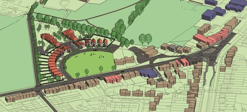
Appendix A: Illustration of potential
acceptable design solutions
18Newgatestreet Road Development Brief – draft for public consultation (September 2020)
Plan showing illustrative design solution to achieve the objectives set out in this Brief
19Newgatestreet Road Development Brief – draft for public consultation (September 2020)
Three dimensional modelling of the above illustrative scheme
20Newgatestreet Road Development Brief – draft for public consultation (September 2020)
21You can also read