NORTH DEVON UNESCO BIOSPHERE RESERVE NATURE RECOVERY PLAN, 2021-25
←
→
Page content transcription
If your browser does not render page correctly, please read the page content below

NORTH DEVON UNESCO BIOSPHERE
RESERVE
NATURE RECOVERY PLAN, 2021-25
OUR CONTRIBUTION TO TACKLING THE GLOBAL ECOLOGICAL EMERGENCY

ACTION PLAN FOR WETLANDS AND WATERBODIES

________________________________________________________
               VISION FOR NATURE IN WETLANDS AND WATERBODIES BY 2030

   By 2030, nature in our wetlands and waterbodies is recovering. Re-naturalised floodplain
 and other riparian land provides a mosaic of habitats for wildlife and creates opportunities
 for dynamic rivers and streams. Wide corridors of scrub, floodplain meadow and woodland
       alongside watercourses act as buffer strips from pollution and connect previously
fragmented habitats. Habitat restoration (including on the degraded blanket bogs of Exmoor
 and Dartmoor) and creation have increased landscape connectivity and natural river flows.
Water quality has improved with fewer sources of diffuse and point pollution. Barriers to fish
    movement and migration have been removed, large woody debris and clean spawning
    gravels are widespread: salmon are recovering. Beavers have colonised all catchments,
  creating nature-rich and climate resilient habitats. Expanding networks of Culm grassland
  support thriving (meta)populations of marsh fritillary butterflies and narrow-bordered bee
   hawk-moths. The drumming of snipe and cries of breeding lapwing and curlew are heard
   once more, and willow tits sing in wet woodlands. Non-native invasive species now have
  minimal impact. Altogether, catchments support abundant and increasing wildlife ranging
          from aquatic plants and invertebrates to eels and freshwater pearl mussels.
________________________________________________________
         Please read this plan in conjunction with the Introduction / Overview chapter

CONTENTS

Action Plan for Wetlands and Waterbodies                                                                      1
PART I: SCOPE AND MAP OF THE HABITATS COVERED BY THIS ACTION PLAN                                             2
  Map of the Habitats covered by this Action Plan                                                             3
PART II: PRIORITY ACTIONS FOR NATURE’S RECOVERY IN WETLANDS AND WATERBODIES                                   4
  Indicators                                                                                                  8
PART III: SUPPORTING INFORMATION                                                                              8
  Importance for nature                                                                                       8
     River, streams and floodplains                                                                           8
     Reservoirs and Ponds                                                                                     9
     Wet woodlands                                                                                            9
     Purple moor grass and rush pastures                                                                      9
     Blanket bogs, upland mires and flushes and upland heathland                                             10
  Baseline and condition / trends (particularly since 2010)                                                  10
  Root causes to be addressed                                                                                12
  Benefits / Ecosystem services                                                                              14
  Main Achievements 2010-2020                                                                                14
  Cross-cutting issues with other action plans                                                               15
  Drafting group for this Action Plan                                                                        15
Annex 1 River Water Framework Directive (WFD) data                                                           17
Annex 2. Culm grassland data                                                                                 17

PART I: SCOPE AND MAP OF THE HABITATS COVERED BY THIS ACTION PLAN

This plan covers:

Rivers and streams: These include the entire river systems of both the Taw (from its headwaters on Dartmoor
and SW Exmoor) and the Torridge (from its headwaters between Hartland and Woolsery and on Dartmoor),
including all the tributaries and the streams that flow into them throughout their catchments. It also includes
the streams and rivers running directly to the sea from Hartland to Lynmouth (Welcombe stream, Hartland
stream, Abbey River, Bideford Yeo, Barnstaple Yeo, Bradiford water, Caen, Umber, Heddon, West Lyn and East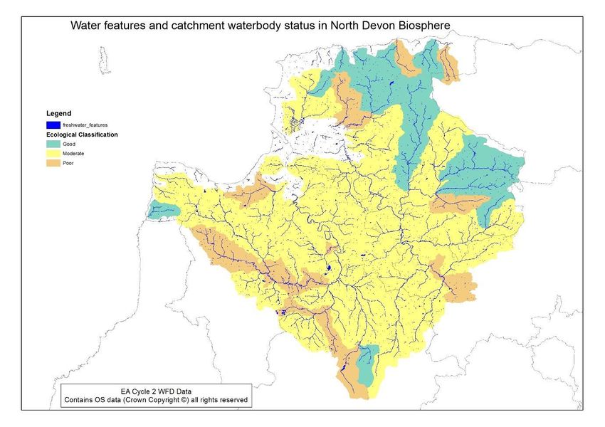
Lyn). It addresses nature in the river/stream channel, the banks and the riparian zone. The plan considers
these rivers and streams (and their floodplains) down to the zone of tidal influence.

Riverine floodplains: These are small and narrow in the upper/steeper sections of the rivers (and throughout
the coastal streams) but become larger and much wider in the middle and lower reaches of the main rivers.
The larger floodplains are often farmed to within a few metres of the bank.

Reservoirs and farm ponds: There are several small reservoirs and artificial lakes scattered throughout the
Biosphere area, the main ones being Wistlandpound, Meldon Reservoir and Meeth Quarry. Many farms and
landholdings already have ponds with a minimum estimate of at least 1,000 in the Biosphere. These are often
neglected or not designed for optimum wildlife value.

Wet woodland: Wet woodland is frequent throughout the Biosphere reserve in places with impeded drainage
and in valley bottoms. Such woodlands are often associated with Culm grasslands and occasionally with
riverine floodplains.

Purple moor grass and rush pastures (Culm grasslands): These are widespread on heavy clay soils throughout
the Biosphere, the reserve holding a significant proportion of the national resource of this habitat type. Sites
are fragmented and often neglected or under inappropriate management. A few of these areas are protected
as SSSIs or SACs, but most are unprotected.

Upland blanket bogs, mires and wet heaths of Dartmoor: These lie in the highest parts of the catchments
within the Biosphere boundary and the Dartmoor National Park. These habitats are of high nature
conservation value and support downstream ecosystems in the Biosphere through their water regulation
functions. (NB. The dry heaths of Exmoor are covered in the Coast action plan).

MAP OF THE HABITATS COVERED BY THIS ACTION PLAN
Figure 1: Map of details rivers network in Biosphere
Figure 2: Water features and catchment waterbody ecological status in the North Devon Biosphere

For specific targeting opportunities, please also refer to the Nature Recovery Network maps for Devon,
expected to be published by the Devon Local Nature Partnership during 2021.

PART II: PRIORITY ACTIONS FOR NATURE’S RECOVERY IN WETLANDS AND
WATERBODIES

The following actions have been identified as priorities for the period 2021-25 to progress towards the 2030
Vision and overall Goals of the Biosphere Nature Recovery Plan. The lead partner for each action (shown in
bold) will actively engage with the other partners to drive implementation and report on progress. In general,
resources for the actions are not yet secured and the partners will examine ways to integrate the action into
their own programmes, as well as seeking new resources (and partners) where necessary. Therefore, being
listed as a lead or partner organisation does not imply a commitment of new resources but does confirm
support for collaborating to deliver the ambition and principles of the actions. Partners will work with and
support farmers and landowners to deliver this action plan, using the incentives of the existing Countryside
Stewardship scheme, the new Environmental Land Management scheme, green finance and other projects.

These actions have been developed following a careful, fresh examination of the state of nature in the
Biosphere and of the underlying reasons for decline and loss, focussing on the current, on-going, factors which
are driving nature’s decline. See Part III below for details.

Much good work has been done over the last decade and this is also outlined in Part III, along with issues that
are shared between this and the other four plans.
Habitat-related actions                                                 Lead / Partners   Budget         By
                                                                                          source         when
A1. Further improve 100 km of prioritised river spawning habitat to     WRT, DWT, EA,     EA             2025
increase fish recruitment by removing or making passable at least 5     Fishing Assoc.,
prioritised barriers to migration.                                      NT, Landowners
A2. Further improve 100 km of prioritised river spawning habitat to     WRT, DWT, EA,     EA             2025
increase fish recruitment by ensuring adequate habitat type,            Fishing Assoc.,
through woody debris introduction and gravel augmentation /             NT landowners
cleaning.
A3. Restore and re-naturalise 200 ha of riverine floodplain to create   WRT, DWT, EA,     EA, CSS /      2025
wildlife-rich mosaics of wetlands, scrub and wet woodlands by re-       Fishing Assoc.,   ELMs, green
establishing hydrological connections, creating scrapes and pools,      NT, FC,           finance,
and allowing natural processes to re-establish.                         Landowners        private
                                                                                          investment
A4. Establish buffer strips of at least 4m width along 50km of          WRT, DWT, EA,     EA, CSS /      2025
prioritised river and stream wildlife corridors (= 20 ha) including     NE (CSF),         ELMs, green
both passive and active management enabling natural regeneration,       Fishing Assoc.,   finance,
tree planting and management and bank protection, recognising           NT, FC,           private
that unshaded and unstable riverbanks can also be very important        Landowners        investment
habitats for invertebrates as well as breeding sand martins.
A5. Create 15 ha of wet woodland and associated wetland habitat         WRT, DWT, EA,     EA, CSS /      2025
(excluding species-rich wet grassland), ensuring that existing wet      Fishing Assoc.,   ELMs, green
woodlands are managed appropriately and in favourable or                NT, FC,           finance,
improving condition.                                                    Landowners        private
                                                                                          investment
A6. Create 200 ha of new species-rich wet grassland as well as          DWT, NT,          EA, green      2025
protect and restore existing areas.                                     Landowners        Finance,
                                                                                          DCC (Flood
                                                                                          risk), CSS /
                                                                                          ELMs,
                                                                                          private
                                                                                          investment
A7. Create or restore 100 ponds, scrapes, reed/sedge beds to create     DWT, WRT NT,      CSS / ELMS,    2025
wildlife habitat as well as manage run-off.                             EA, NE,           Green
                                                                        Landowners        Finance,
                                                                                          EA & DCC,
                                                                                          private
                                                                                          investment
A8. Buffer the rivers from road and urban run-off and ensure clean      DCC, SWW          DCC and        2025
water is separated from combined sewerage systems including                               District
septic tanks and rural sewage systems leading to a 50% reduction in                       Councils
the number of Combined Sewer Overflow spills.
A9. Engage landowners in re-naturalising/wilding 100 ha of species      DWT, EA, NT       CSS / ELMs,    2025
poor habitat on the Taw and Torridge headwaters, to restore a
                                                                        Landowners        green
mosaic of culm grassland, wet woodland and other wetland habitats
                                                                                          Finance,
through natural processes.                                                                private
                                                                                          investment
A10. Restore 226 ha of Dartmoor’s blanket bog: 176 ha on the upper Dartmoor CSS / ELMs 2030
catchment of the Okement (including the Cranmere Pool area), plus National Park
54 ha on the upper catchment of the Taw (including part of the Authority, SW
Hangingstone project area). Peatland
Partnership,
Landowners
A11. Continue restoration of 280 ha of Exmoor’s degraded blanket Exmoor CSS / ELMs 2030
bog to enhance the resilience of Exmoor moorland for ecological National Park
and ecosystem service gains. Authority and
partners,
Landowners
A12. Reduce the occurrence of point source and diffuse pollution. EA, NE (CSF), EA 2030
Category 1 pollution incidents reduced by 50% from 9 (2010-19) to 4 Landowners &
or less (2020-29). Category 2 and 3 pollution incidents reduced by Businesses
50%. Increased proactive targeted Silage, Slurry and Agricultural Fuel
Oil (SSAFO) and Farming Rules for Water compliance checks
completed.
A13. Designate 50 new Wetland habitat County Wildlife Sites, DBRC DCC/DWT & 2030
increasing awareness and protection of these invaluable resources external
funding
sources
Species-related actions Lead / Partners Budget By
source when
B1. Complete feasibility study by 2023 and start implementation of DWT, EA EA, Private 2025
freshwater pearl mussel reintroduction programme with suitable funding,
headwater habitat created on the Torridge; establish a captive Research
breeding hatchery and ark population; achieve two rounds of FPM
funding
captive breeding.
B2. Work with affected stakeholders via the catchment partnership DWT, Beaver Grants, 2025
in north Devon to understand, prepare for and mitigate any Trust, NT,
green
potential problems arising from beaver and vole reintroduction and Landowners finance,
set up a management programme between beneficiaries and those
impacted to allow reintroduction of beavers and water vole in the private
Biosphere river systems, making use of opportunity areas where investment
there is landowner support.
B3. Control and if possible eradicate, non-native invasive plants DWT, WRT, NT, Volunteers, 2025
including Himalayan balsam over 50km of river in the Taw and Fishing Assns., private
Torridge headwaters according to a clearly prioritised strategy (see Landowners, investment,
enabling actions). ENNIS EA
B4. Engage with user groups to raise awareness and promote EA, WRT, EA 2025
biosecurity and control measures to prevent further spread of Fishing Assns.
current population of signal crayfish in the Torridge. Landowners
B5. Promote voluntary 100% catch and release fishing on rivers with EA, WRT, N/A 2025
fishing clubs and associations through voluntary sign up Fishing Assns.
B6. Improve habitat connectivity and reintroductions to allow meta- Butterfly Grants, CSS / 2025
populations of marsh fritillary and narrow bordered bee-hawkmoth Conservation, ELMS,
to extend in distribution with populations stable and increasing. DWT private
investmentB7. Provide 200 nest boxes for willow tits in 20 wet woodland sites Devon Birds, CSS /ELMS 2025
lacking suitable natural nesting sites and monitor success and Biosphere team private
predation. This could include creating standing deadwood as DWT, NT, investment
alternative nesting sites. Landowners
Enabling actions Lead / Partners Budget By
source when
C1. Secure new funding sources for the restoration of river and Biosphere EA, Green 2025
stream corridors where nature conservation is given priority through team, WRT, NT Finance,
top-up / challenge funds to ELMS. Water
companies,
C2. Increase advisory capacity by five posts to allow farmers to take DWT, WRT, Statutory 2025
re-naturalised/rewilding options including information on managing Biosphere agencies
appropriate grazing and water levels, invasive species etc. Including
training existing Countryside Stewardship advisers/land agents.
C3. Prepare a prioritised framework for addressing threats from NIWG, DISI, £2000 2022
non-native invasive species and adopt best practices for their ENNIS Student
management in close collaboration with DISI and the ENNIS project.
project
C4. Double public participation, education and awareness through Biosphere EA 2025
the facilitation of citizen science monitoring of the rivers (e.g. river team, WRT
fly, citizen science, eyes on the river) and coordination (e.g.
catchment hub). Contribute to advocacy for better standards for
bathing water quality standards.
C5. Increase awareness of pollution and Farming Rules for Water Biosphere EA 2025
and guidance on when Incident Hotline should be used so that all team, WRT,
farmers are aware. Education campaign with farmers and the DWT, EA
general public regarding the Farming Rules for Water and Storing
silage, slurry and agricultural fuel oil (SSAFO) regulations.
C6. Encourage all fishing clubs and riparian owners to have a nature Biosphere EA 2025
recovery plan for their section of river, including habitat restoration, team, Fishing
juvenile fish recruitment and wider nature values. Assns., Beat
Owners
C7. Promote the Obstacle app and increased reporting of any WRT N/A 2025
barriers to species migration.
C8. Raise awareness of the importance of wet woodlands and Culm Biosphere FC 2025
grassland for nature and provide guidance on appropriate team, DWT
management.
Monitoring Priorities Lead / Partners Budget Freque
source ncy
M1. Third party active nutrient monitoring in river upstream and WRT ? Contin
downstream of all sewage treatment works pre-empting future uous
freshwater bathing waters designations (linked to water company
discharge assessments).
M2. Salmon Fry Index Surveys in all catchments for complete WRT Partnership Annual
overview linked to indicator assessment. projects
M3. Evaluate water quality of Taw/Torridge and north Devon WRT, EA, ?, volunteers Multipl
streams through citizen science water quality assessments Biosphere team, e
AONB,
CoastwiseM4. Citizen science programmes for monitoring the indicator species Biosphere Volunteers Depen
mentioned above team, expert dent on
groups species
M5. Monitor the condition of Wetland County Wildlife Sites DBRC DCC/DWT & Annual
LPAs
Research Priorities Lead / Partners Budget Freque
source ncy
R1. Sustain and increase the survey effort for marsh fritillary and DWT/BCT ? ?
narrow-bordered bee hawk-moth on Culm Grassland
INDICATORS
These three outcome indicators will be monitored to track the overall impact of plan implementation.
Means of Responsible
Indicator Baseline 2020 Target 2030 verification for
monitoring
Salmon populations WRT Salmon Increasing numbers WRT & EA WRT & EA
fry data electrofishing
Declining
numbers
Number of water bodies 15 30 EA WFD EA
at good ecological status monitoring
where
available
and/or WRT
Citizen
Science work
Area of new wetland 0 ha - Wet woodland creation: 5 ha Project DWT &
habitats created and - Wet woodland enhancement: reports, GIS DBRC
restored (river corridor, 15 ha layers, Agri-
floodplains, wet scheme
woodland and culm - Restored floodplain: 200 ha maps
grassland) - Purple moor grass & rush
pasture enhancement: 200 ha
- Restored blanket bog: 506ha
- Watercourse enhancement
(leaky dams, stage 0, etc): 13.5
km
- New ponds / seasonally wet
scrapes: 150
- Additional 100ha of developing
wetland habitat from current
pasture land (mix of developing
rush pasture, wet woodland)PART III: SUPPORTING INFORMATION IMPORTANCE FOR NATURE RIVER, STREAMS AND FLOODPLAINS Mammal species present include otter (occurs throughout the river systems of the Biosphere), bats (particularly Daubenton’s) and water shrew; historically beavers were present and reintroduction programmes have started elsewhere in Devon. Additionally, these habitats are important for the re-colonisation of recently lost species such as water vole, facilitated by the management of mink populations. Birds include goosander, grey heron, dipper, grey wagtail, kingfisher, common sandpiper and sand martin. Fishes include Atlantic salmon, sea/brown trout, lamprey, bullhead and eel. Historically sturgeon and shad were present. A huge diversity of insects is associated with riverine habitats including white-legged dragonfly, beautiful demoiselle and numerous beetles and flies. The Taw and Torridge hold small (and non-breeding) populations of the freshwater pearl mussel, being the only remaining rivers in southern England to support this IUCN Red Listed “Critically Endangered” species (also a Devon Special Species). The Torridge holds an estimated population of fewer than 1,000, and the river Mole (Taw tributary) fewer than 100 mussels, with occasional individuals found elsewhere. No mussels in north Devon are thought to be younger than about 60 years old, and there is no known recruitment, although two rounds of captive breeding were completed in 2017/18. Amphibians and reptiles include common frog, toad and great crested newt. Mosses and liverworts including the UK BAP and Devon Special Species multi-fruited river moss. RESERVOIRS AND PONDS Reservoirs are highly modified due to abstraction of water (causing fluctuating water levels), impoundment of once-flowing rivers, interruption of natural conveyance, and the introduction of fish, but can support important waterbird populations such as ducks, great-crested grebe and visiting ospreys, with valuable bankside vegetation for a diversity of wildlife. Ponds can be rich in wildlife including otters, grey heron, kingfisher, moorhen, common frog and toad, dragonflies and damselflies, water beetles and a diversity of aquatic plants. These still water bodies provide important habitat diversity and can act as attenuation or filtration to improve surface water quality. WET WOODLANDS Characterised by alder and grey willow, sometimes together with downy birch. Ground flora includes various sedges, marsh marigold and occasional patches of bog mosses. The habitat supports huge numbers of insects such as craneflies and fungus gnats along with many nationally scarce or threatened invertebrates such as the fly Coenosia pudorosa, a Devon Special Species, and the beetle Epuraea distincta. Among the birds, the willow tit, nationally a rapidly declining and much threatened bird and a Devon Special Species, is a speciality. Rich and diverse moss and liverwort floras are frequent, together with lichen communities characterised by Lobaria and Sticta species. Hazel gloves fungus, another Devon Special Species, frequents damp woodland, especially alongside watercourses. Wet woodland is included within Section 41 list of Habitats of Principal Importance of the NERC Act (2006) and as such is recognised as a priority habitat for conservation effort. PURPLE MOOR GRASS AND RUSH PASTURES
Culm grassland is a type of species-rich marshy grassland found across the Culm Measures of northwest Devon
and northeast Cornwall. It occurs on poorly-drained acidic soils on the lowlands and upland fringe and is also
known as rhôs pasture. Culm grassland is a variable habitat, including the priority (Section 41) habitat purple
moor grass and rush pasture. Devon contains 80% of this habitat in England, and 8% of that in the whole of the
UK. It supports some of Devon’s most threatened species such as the marsh fritillary (not present on
Dartmoor), small pearl-bordered fritillary, narrow-bordered bee hawk-moth, curlew, snipe and barn owl. The
very rare and highly threatened dingy mocha moth is associated with scattered scrub on one, maybe more,
Culm grassland sites. Likewise, the Vulnerable (to UK extinction) hoverfly Sphaerophoria potentillae has two
out of three known UK sites on Culm Grasslands in the Biosphere. This is a Devon Special Species, as are the
marsh fritillary and narrow-bordered bee hawk-moth.

BLANKET BOGS, UPLAND MIRES AND FLUSHES AND UPLAND HEATHLAND
The River Taw and two of the Torridge’s major tributaries, the East Okement and the West Okement, arise on
the blanket bog of Dartmoor, a mantle of thick peat. This is the most southerly blanket bog in Europe. It forms
part of the Dartmoor Special Area of Conservation, and as such is recognised as being of international
importance. The valleys running down from the blanket bog contain extensive mires and flushes that are
unparalleled in upland Britain, supporting plant communities rarely found elsewhere and of exceptionally fine
structure and species composition. The blanket bog, mires and flushes found within that part of Dartmoor
which lies within the Biosphere Reserve are no exception to this – all are of high quality. They support a small
but apparently stable population of breeding dunlin - the most southerly in the world, while the golden plover
which used to breed here have been lost in recent years. A few valley mires in the Biosphere have populations
of bog orchid, a species that is threatened throughout Europe. These mires also support rich plant
communities with species like sundews and pale butterwort, dragonflies like the keeled skimmer, and healthy
numbers of breeding snipe. The rivers themselves are acidic and fast-flowing, often characterised by moss-
covered boulders. Here dipper and grey wagtail are frequent, fern communities are luxuriant, including royal
fern, and brown trout often common. The bogs, mires and flushes of Dartmoor are typically found in an
intricate mosaic with upland wet heathland and acidic grassland that also support the declining ring ouzel
(likely to become extinct as a breeding bird of Dartmoor). That part of Exmoor which falls within the Biosphere
also has blanket bog and mires, although in smaller amounts and of lower quality. These feed two major
tributaries of the Taw, the Rivers Bray and Mole, and the West Lyn and East Lyn. Snipe, grey wagtail and
dipper are frequent here too. Cornish moneywort is a plant of particular note associated with the valley mires.

BASELINE AND CONDITION / TRENDS (PARTICULARLY SINCE 2010)

Habitat      Baseline     Trend**        Trend** QUALT                 Comments (e.g. main reasons and sources
             Area         QUANT                                        of information)
             (ha)*
Rivers and   67 ha        Stable         Decline                       Ecological status classified under WFD has
streams      (est. as                                                  declined from 18 water bodies with good
             length x                                                  ecological status in 2016 to 15 in 2019.
             3.5m                                                      Area of river is not typically used but rather
             average
                                                                       length – Taw: 74km & Torridge 93km.
             width)
Floodplain 6,452 ha Stable Poor Decline Estimate in NE Analysis (coastal and
grazing (see condition riverine).
marsh Annex 3 Wider floodplains are mainly under
of Intro.)
intensive agriculture.
Lakes, 943 ha Not known Not known Surface water status under WFD reflected in
reservoirs (see figures above.
and ponds Meeth Quarry nature reserve.
Annex 3
of Intro.) Biosphere data.
Magic.
Wet 2,447 ha Not known Probably declining While on the one hand this habitat is in
woodland (see places expanding as willow colonises fields
that have come out of production, in others
Annex 3
long-established sites are being degraded
of Intro.)
by drainage, mismanagement or even
clearance. It suffers through lack of
recognition and awareness of its value for
nature within forestry, nature conservation
and farming sectors.
Purple 16,222ha Declining Probably declining Baseline estimate is probably too high.
moor grass (see (see Annex Vulnerable to damage or destruction
and rush 2) through neglect (lack of grazing,
Annex 3
pastures overgrazing, scrubbing up, poorly sited tree
of Intro.)
planting & over management) – see below.
Blanket 4,094 ha Improving Exmoor moorland mosaic: See National Park management plans.
bog & (see (where 2,300ha in unfavourable 90% of this areas is notified as SSSI or CWS
Peatlands under recovering condition and
Annex 3 ENPA and DNPA and partners are seeking to
restoration); 300ha in unfavourable no
of Intro. enhance the resilience of moorland with
otherwise change. Peatlands: 700ha
and info. stable or of which 280ha is under particular focus on restoring degraded
provided declining restoration. blanket bog for ecological and ecosystem
by the service gains.
Dartmoor: 1,155 ha of
NPAs to
blanket bog of which 24
the right)
ha is being restored.
Lowland 4,234 ha ? ? Includes Reedbeds.
fens (see
Highly improbable there is so much lowland
Annex 3
fen in the Biosphere.
of Intro.)
Upland 162 ha ?n ? See National Park management plans
flushes,
(see
fens and
Annex 3
swamps
of Intro.)
Upland 1,044 ha ? ? 93% of this areas is notified as SSSI or CWS
wet
heathland
(Dartmoor)(see
Annex 3
of Intro.)
*For baseline areas refer to Annex 3 in the Introduction regarding confidence assessments
** Trend estimates from expert opinion unless otherwise evidenced
Indicator Species Trend Comments (e.g. main reasons and sources of information)
QUANT
Mammals
Otter Increasing Reflects legal protection and cessation of persecution.
Birds
Willow tit (for wet woodland) Rapidly Devon Bird Atlas
declining
Declining
Dipper (for rivers & streams Devon Bird Atlas
Declining
Kingfisher (for rivers streams Devon Bird Atlas
and ponds)
Dunlin (Breeding, Dartmoor Stable
Dartmoor Delivery Plan for Dunlin
blanket bogs)
Reptiles
Grass snake ?
Amphibians
Toad ?
Great crested newt ?
Fish
Atlantic salmon Declining Categorised by EA as ‘At Risk’ on the Torridge and ‘Probably at
from low Risk’ on the Taw and Lyn (2019). Fry Index Surveys exist for the
baseline Taw and Torridge in some years and can be used as a baseline
for the young-of-the-year salmon and trout. Evidence of
recruitment is an excellent indicator of river health and should
be performed annually.
Invertebrates
Freshwater pearl mussel Declining Critically endangered, not breeding
Devon carpet moth Stable
Narrow-bordered bee hawk- Declining
moth
Marsh fritillary ?
Wood white
?
Higher Plants
Wavy St John’s-wort StableMay be increasing, reflecting re-introduction of cattle to many
Lesser Butterfly orchid Declining Culm grassland sites.
Ragged robin Has apparently been lost recently from many Culm grasslands.
Stable
Could be useful for citizen science.
Lower Plants
Multi-fruited Cryphaea moss Stable Occurs on the Torridge (near Beaford Bridge) and Taw (near
Umberleigh); and has recently (2019) been found beside the
River Mole (near Arshaton Wood).
Fungi and lichens
Hazel gloves fungus Increasing Increase in records may just reflect increased recording effort.
Lungwort lichens Declining Sensitive to air pollution.
ROOT CAUSES TO BE ADDRESSED
Root Causes Solutions
Loss of natural riparian habitats and lack of ● Encourage/incentivise landowners to provide wide
dynamism: corridors/buffers for rivers and streams.
Rivers are of poor quality and are disconnected ● Encourage/incentivise landowners to restore
from their floodplains, and there is a paucity of floodplains.
riverine wetlands and early successional habitats. ● Conserve, create and restore species-rich habitats
Floodplains are intensively farmed, and riparian in these areas.
corridors are often very narrow strips of simple
● Identify floodplain sites where natural processes
vegetation unable to provide suitable wildlife
habitat, act as a buffer from pollution, or slow can rewild the area.
the flow of water during floods. Loss of
floodplain connectivity has increased stream
power, depth and incision, changing the
geomorphology of the river.
Loss of in-river habitat: Historic activities which ● River restoration work to restore in-river habitat
included removing woody debris, dredging and (e.g. removal of hard engineering that impedes
straightening watercourses, and excavating river natural processes, ceasing practices such as
gravels has left rivers depleted of habitat for
dredging, stone removal and tidying of
nature.
watercourses that are detrimental to maintaining a
healthy river habitat)
Increased fine sediment ingress from bank ● Communication about the importance of these
erosion and run-off restricts the supply of features for rivers/streams.
oxygen. ● Enforcement and tougher penalties for carrying out
non-permitted work to watercourses.
● Reduction of sediment pathways through
attenuation and filtration.
Land use and drainage in the catchments: ● Implement natural flood management projects to
Conversion/drainage of natural wetland habitats hold more water in the upper sub-catchments.
(blanket bogs, mires, wet pastures) as well as
woodlands and hedges in the catchments mainly
for agriculture, has resulted in changes to thespeed at which water moves through river ● Allow ecologically depleted land to re-wet and
catchments affecting riverine wildlife and develop into scrub and woodland or be planted
resilience to flooding and droughts. with trees.
● Restore hedges in strategic locations to reduce run-
Culm grassland is vulnerable to damage or off.
destruction through neglect and unfavourable ● Improve soil management and biodiversity for
grazing practices, scrub invasion, inappropriate healthier soils and increased infiltration.
management (drainage, improvement, ● Raise awareness of the importance of Culm
eutrophication, tree planting and pond creation). grassland and appropriate management.
Climate change: More frequent and severe ● Reduce emissions of GHGs and sequester carbon in
droughts and floods, and increased summer blanket bogs and woods.
water temperatures can all negatively affect ● Restore the functioning of river and wetland
aquatic wildlife.
systems to mitigate the impacts of climate change
(e.g. reverse drainage works, restore floodplain
connectivity).
● Restore riparian corridors of native broadleaved
trees to provide shade and keep rivers cool.
Barriers in rivers: weirs and other water ● Map the spawning habitat and prioritise increased
management structures inhibit the migrations of connectivity.
fish and interrupt natural conveyance. Both ● Locate and assess passability of barriers and
upstream and downstream migration are
remove or provide suitable fish passes or
essential to healthy rivers/natural processes.
easements where removal is not feasible according
to the EA’s 5-Point-Approach to salmon recovery.
● Mitigate or reinstate conveyance to improve
natural habitat.
Non-native Invasive Species: Main species of ● Map distributions and assess baseline.
current concern are Himalayan balsam, ● Prioritise and implement management and control
Montbretia, Japanese/Himalayan knotweed, with support of landowners and volunteers.
Giant hogweed, North American signal crayfish,
● Improve biosecurity practices and awareness.
American skunk cabbage and American mink.
Loss of keystone species: Loss of ecosystem ● Reintroduce beavers and water voles.
engineers, most notably beavers, has inhibited ● Conserve existing freshwater pearl mussel
natural river corridor dynamics and led to the populations.
decline of wetlands and associated flora and
● Establish native freshwater pearl mussel hatchery
fauna. Freshwater pearl mussel populations are
endangered and not able to breed. In the past and reintroduction programme to suitable
they would have played an important role in locations.
water purification.
Diffuse pollution: primarily from organic and ● Apply fertilisers, manures and pesticides according
inorganic fertilisers as well as the input of to laws and best practice guidance.
sediments arising from run-off from poorly ● Reduce nutrient and sediment delivery to water
managed farmland, but also from accelerated
courses by creating riparian buffer strips, creating
riverbank and bed erosion.
new hedges along contours, and constructing
wetlands to intercept pollutants.Increasingly powerful pesticides are used in ● Ensure farms have the necessary infrastructure and
agriculture and runoff or drift delivers them to access to loans/grants to improve yards and slurry
watercourses. storage.
● Raise awareness of Farming Rules for Water and
other legislation.
● CSF to provide advice and access to grant funding.
● EA to carry out spot-checks and enforce legislation.
Point source pollutants: Industry examples from ● Monitor for and publicise pollution incidents,
ball clay quarries, anaerobic digestion plants, enforce laws and prosecute.
dairy industry, road runoff. Overflows from septic ● Separate clean and dirty water to reduce burden
tanks and inadequate sewage systems can result
on treatment.
in severe pollution; endocrine disrupting
chemicals from sewage treatment are known to ● More SUDS schemes to reduce the burden of
affect fish reproduction. heavy rainfall on waste-water treatment plants
(WWTPs).
● Increased use of constructed wetlands and
bioremediation.
● Greater investment in WWTPs and combined
sewer overflows.
● Water companies regulated more closely, without
the reliance on self-reporting.
BENEFITS / ECOSYSTEM SERVICES
Provisioning services include rivers, streams, reservoirs and ponds as sources of water for domestic,
agricultural and industrial use; fish and some edible plants for consumption; timber from bankside trees; and
floodplains and Culm grasslands provide grazing for livestock and soils for crops.
Regulating services include (reservoirs and ponds, wet woodlands and Culm grasslands) holding back water in
the catchment, buffering high and low water flows in rivers which is important for riverine wildlife and for
reducing flood risk for local communities (a particularly important role of floodplains). These wetlands and the
rivers themselves also capture sediments and nutrients from poor land management through natural filtration
and therefore improve water quality. Riparian habitats play a key role in stabilisation of soil/sediment. Historic
importance of freshwater pearl mussel for filtering water.
Facilitating services include primary production, carbon sequestration, nutrient cycling and soil formation.
Cultural services include recreation (angling, hiking, kayaking, birdwatching) and tourism; intellectual and
aesthetic appreciation (study, citizen science, research); spiritual and symbolic appreciation (sense of place,
the arts and folklore); health and wellbeing. Rivers and wetlands contribute key features to landscape quality
and character.
MAIN ACHIEVEMENTS 2010 -2020
Since 2012 the Northern Devon Nature Improvement Area (NIA), led by Devon Wildlife Trust with a number of
Biosphere partners, has delivered a series of projects working with landowners and communities to improve
the water environment. These have included:● NIA phase 1 April 2012- March 2015 – 1,500ha habitat restored and 80 ha new habitat created; numerous
other farming advisory and community outputs, many of which were related to wetland habitats.
● NIA phase 2 April 2015 – March 2021 Restoring Freshwater Mussel Rivers in England (2015–18) and
follow up work; Torridge Headwaters Facilitation Project (2015-20); Culm Grassland Natural Flood
Management Project (2016–21); Torridge River Restoration Project (2019–21). The projects from 2015-20
have together achieved the following: 457 ha Culm grassland restored; 99 ha new species rich wet
grassland created and monitored; 73 km of river improved for wildlife and water quality; 1,188 one-to-one
advisory visits made to farms by DWT staff; 157 farms made significant practical improvements for
wildlife; 118 workshops organised for farmers and landowners; over £1.45M invested in north Devon’s
natural environment; 43 volunteer work parties; 4 endangered freshwater pearl mussel populations
protected; 2 successful rounds of captive breeding of freshwater pearl mussel; 304 schoolchildren
engaged with the natural environment.
Over the past 10 years Westcountry Rivers Trust has worked with the Rivers Taw Fisheries Association and the
Environment Agency in a strategic effort to improve fish migration up the main River Taw catchment to
Dartmoor and the main sub-catchment, the River Mole, to Exmoor. This has involved barrier removal, nature-
like passes, technical fish passes and easements addressing 12 structures. Alongside this in-river work the Trust
has also worked with land managers to manage water pollution into the Taw and improve woodland
management on farm. Working alongside the above WRT has continued to monitor the catchment and direct
restoration and conservation efforts towards areas in response to monitoring: a dynamic and adaptive
management process. Funding for the above through WRT over the last 10 years totalled £3.25m. WRT is
active across other areas of north Devon, including the River Caen, Knowle Water, Bradiford Water and River
Yeo (Barnstaple) that discharge directly to the estuary.
Fishing clubs/associations are increasingly contributing to conservation work through catch and release, and
active habitat management (e.g. managing riparian vegetation, controlling Himalayan balsam, improving
spawning habitats and monitoring).
Within the Biosphere boundary, Dartmoor National Park has begun restoration of 24ha of blanket bog as part
of the Hangingstone project area, and Exmoor National Park has begun restoration over 280 ha of peatlands.
CROSS-CUTTING ISSUES WITH OTHER ACTION PLANS
Pasture and arable: Diffuse agricultural pollution and run-off/sedimentation; maize and soil management as
well as enforcement of regulations. Rehabilitation of floodplains and restoration / creation of wetlands, culm
grasslands etc.
Towns and villages: Point source pollution from sewage treatment works, industry and domestic septic tanks.
Run-off from roads.
Trees, woods and hedges: strategic habitat creation to improve the water environment.
Coast: downstream impacts of water quality and quantity on estuarine wetland habitats including associated
flood plains, grazing marshes, fens and saltmarshes.DRAFTING GROUP FOR THIS ACTION PLAN Laurence Couldrick and Adrian Dowding (WRT), Ben Eardley (NT), Steve Edmonds (RSPB), Daniel Griffiths (EA), Mike Moser (NIWG), Lisa Schneidau (DWT), Matt Turley (DWT), Jack Ward (National Trust)
ANNEX 1 RIVER WATER FRAMEWORK DIRECTIVE (WFD) DATA

The 2019 WFD data collected by the Environment Agency shows that none of the 100 water bodies within the
North Devon area meet good or high overall status with 82 classified as moderate and 18 as poor. This is a
worsening in both ecological status (18 were in good ecological status in 2016 compared to 15 in 2019), and
chemical status (all bar one water body passed in 2016 to none passed in 2019). This is due to the inclusion of
PBDs (fire retardants) and mercury assessed in fish (new assessment technique). Ecological failures are
predominantly on the lowland areas with the good ecological status water bodies mostly confined to the
moorland and north coast streams (14 on Exmoor and 1 on Dartmoor). The data suggest that the majority of
ecological failures are due to diffuse and point source pollution coming from sewage discharges, poor nutrient
management on farmland, poor livestock management and poor soil management. Some waterbodies have
barriers to migration causing failing ecological status for fish.

Table 1 Significant Water Management Issues impacting on ecological status

ANNEX 2. CULM GRASSLAND DATA

An update of the Culm Grassland Inventory for north Devon in 2016 (DBRC) indicated an increase in Culm
grassland from 533 sites to 643 sites but this is complicated as new sites have been identified but sites have
also been lost (see Table 2 and 3).

Table 2 Comparison with the previous Culm Grassland Inventory

 Culm Inventory                        Culm Inventory 2008                   Culm Inventory 2016
 Number of sites                       533                                   643
 Area (ha)                             3,863 (includes non-Culm habitat      4,950 (total area)*
                                       e.g. scrub)
                                                                             2,945 (area of Culm)**
* Total area of the site, including any mosaic habitats. **Area of Culm Grassland only

Table 3 Changes to the Culm Grassland Inventory

 Culm Inventory                        Number                                Area (ha)
New sites identified from survey 208 944 (total area) data 522 (area of Culm) New areas of Culm identified 193 794 (total area) from survey data 409 (area of Culm) Sites completely lost 62 190 (total area) Sites partially lost 147 361 (total area)
You can also read