North Hinksey Parish Neighbourhood Plan 2031 Appendices Referendum version March 2021 - Vale of White Horse ...
←
→
Page content transcription
If your browser does not render page correctly, please read the page content below
North Hinksey Parish
     Neighbourhood Plan 2031
           Appendices

          Referendum version
              March 2021

❖ Achieving controlled, sustainable and appropriate
  development.

❖ Protecting elements that are key to the efficient
  functioning and well-being of the local community.

❖ Making North Hinksey Parish an even better place to
  live and work in, now and for future generations.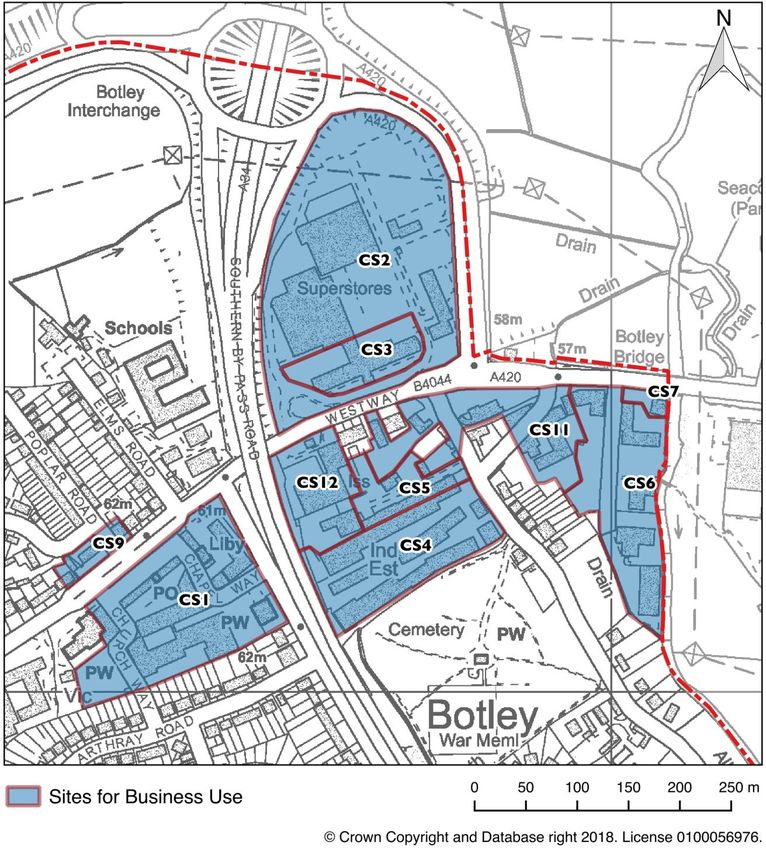
Contents
Appendix A: Additional Parish Maps
• Map A.1 - Character Areas p1
• Map A.2 – Contours p2
• Map A.3 – Satellite Image p3
Appendix B: Housing
• Table B.1 - Sites investigated for potential housing development suitability p4
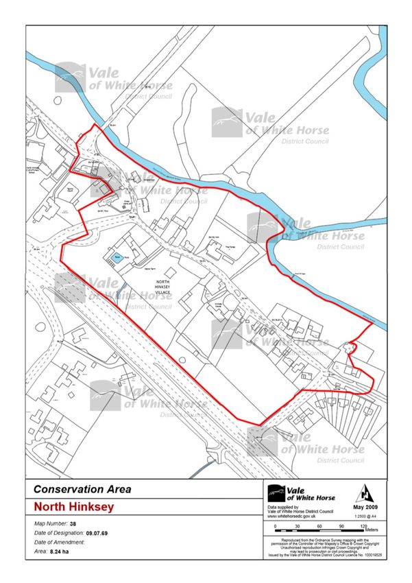
• Map B.1 – North Hinksey Conservation Area p6
Appendix C: Economy & Employment
• Maps C.1(a) and C.1(b) – Designated Business Sites in North Hinksey Parish p7
• Table C.1 - Diversity of businesses in the Strategic Business Areas designated in the
Vale’s Local Plan 2031 Part 1 p9
Appendix D: Transport
• Map D.1 - Bus routes through North Hinksey Parish and Central Oxford p11
• Map D.2 - Cycle routes from North Hinksey Parish to Oxford City Centre p12
Appendix E : Social Infrastructure
• Map E.1 - leisure facilities and venues in North Hinksey Parish p13
• Map E.2 - Social facilities (health facilities, educational facilities, libraries &
cemeteries): p14
• Map E.3 - Historic sites, churches etc. In North Hinksey Parish p15
Appendix F: Utilities
• Map F.1 – Geological Map of North Hinksey Parish (taken from the GWP Consultants
Groundwater Assessment of North Hinksey Parish (July 2017) - Drawing 4) p16
• Map F.2 - Zone of Potential Groundwater Flooding (taken from the GWP
Consultants Groundwater Assessment of North Hinksey Parish (July 2017) -
Drawing 6) p17
Appendix G: Green Spaces
• Map G.1 – designated local green spaces within the Parish p18
• Table G.1 - The National Planning Policy Framework Green Spaces criteria applied to
the green spaces of North Hinksey Parish p24
• Map G.2 - Parish locations rich in wildlife p28
• Map G.3 - known wildlife corridors p29
• Map G.4 - North Hinksey’s valued views (as collected at public consultation
events) p31
• Table G.2 – North Hinksey Views Assessment Grid p38
Appendix H: Oxford Brookes University, Harcourt Hill Campus
• Map H.1 – Harcourt Hill Campus major development site boundary p43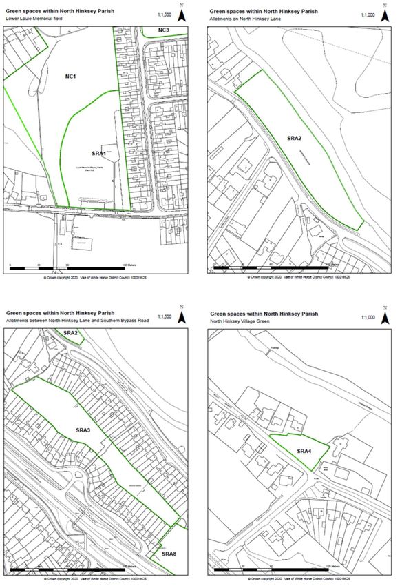
Appendix A: Additional Parish Maps
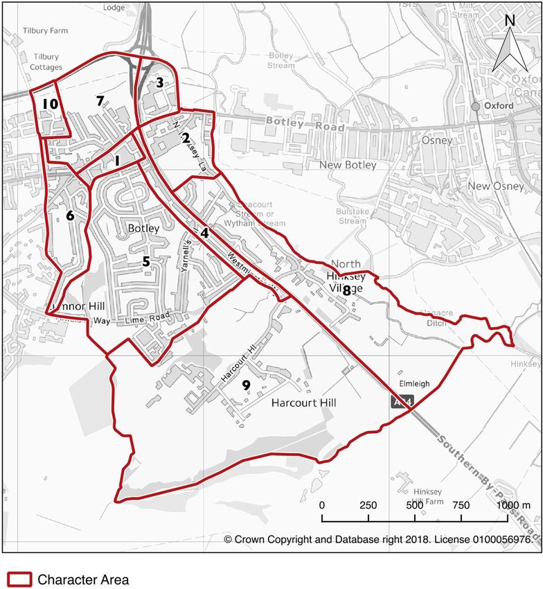
Map A.1 below indicates the locations of the ten Character Areas identified in the North Hinksey
Parish Character Assessment (January 2018). Of these, areas 1 and 3 are commercial / retail, area
2 is a mixture of a historic village and industrial estates, and areas 4 to 10 are predominantly
residential, although Brookes University Harcourt Hill Campus is also a significant presence within
area 9.
Map A.1 – Character Areas:
1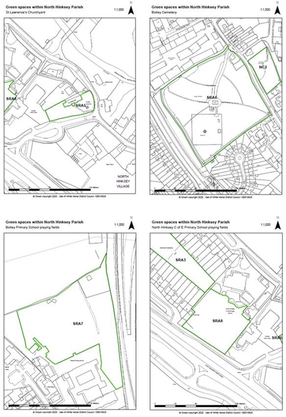
Map A.2 - contours:

2
Map A.3 – satellite image:

3
Appendix B - Housing:
Table B.1: Sites investigated for potential housing development suitability

    Site Location            Description and comment

    1.   North Hinksey       Within the Green Belt on land owned by the rugby club, although
         Village, at far     the identified area of land is on the north-western edge of the
         south-eastern       overall club site, and is only used as an overflow car park, not for
         end.                leisure activities. To the rear of existing housing. Close to the A34.

    2.   North Hinksey       Within the Green Belt to the north west of the rugby club. Located
         Village, adjacent   to the rear of properties on North Hinksey Lane, close to the A34.
         to the A34          Private ownership.

    3    North Hinksey       Land owned by NHPC and identified as an important local green
         Lane, to the        space used as a Community Orchard.
         south-east of
         Botley WI Hall

    4    Land between        Constrained site partly within the Green Belt. Site restricted by
         A420 and Hazel /    required pylon buffer zone. Vehicular access currently not possible
         Poplar / Elms       through recently built Tilbury Fields housing estate to the west, with
         Roads.              other serious access restrictions through the three roads to the
                             south of the site (all narrow roads, pedestrian / cycle access to
                             Tilbury Fields is via Hazel Road, Poplar Road is a Private Road, Elms
                             Road contains a school and doctors’ surgery which is aiming to
                             expand).

    5    Copse on Cedar      Difficult site. Left over space that has degenerated through lack of
         Road                management. Difference in levels. Would require careful eco-
                             development. Identified as an important local green space. Also
                             developers would need to take note of Policy UT1 regarding
                             groundwater issues as it lies within the identified risk zone – see
                             Utilities Appendix A.

    6    Harcourt Hill,      Within the Green Belt. Access issues, with potential increase in
         field opposite      students and academics travelling to Brookes Campus as part of that
         Brookes campus.     redevelopment adding to pressure on the narrow Harcourt Hill Road
                             and Westminster Way even before potentially adding any further
                             housing nearby. See Policies TR1 and TR2 and other comments
                             about transport issues shown under site 7 below. Also utilities
                             issues.

    7    Oxford Brookes     Within Green Belt (see Core Policy 13) and providing important
         University playing leisure facilities for parishioners as well as students. Can be accessed
         fields             from existing routes, however there are transport issues in the
                            vicinity and it would require access from the north to benefit public
                            transport provision. To comply with policies in this Plan the playing

4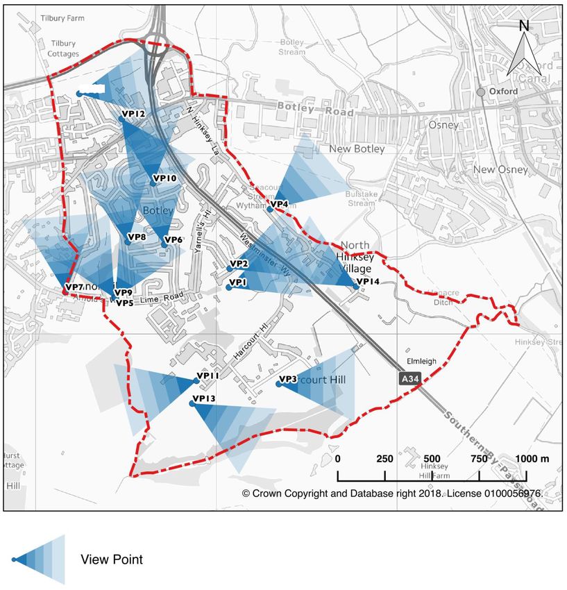
fields would need to be relocated elsewhere on the campus site
                           (impractical), but choice of any housing/accommodation location
                           would also be dependent on an emerging OBU masterplan for a
                           major redevelopment which would require built structures to be
                           located within the same development boundaries as currently (Local
                           Plan Inspector) making this area of the Campus unviable for any
                           housing/accommodation. See Policies SI1, GS1, TR1 and TR2, and
                           section 4.7 of this Plan including Policy BU1.

    8   Oxford Brookes     Depends on emerging Brookes masterplan and would involve
        University Car     relocation of car parking to elsewhere on the overall campus site
        Park               (impractical). See additional comments for site 7 above which also
                           apply here.

    9   Field House site   Currently housing for elderly / sheltered housing. Redevelopment
                           could provide a higher number of housing units of higher quality
                           than at present, but would need to be in accordance with the Botley
                           Centre SPD, and should continue to provide elderly/sheltered
                           housing.

5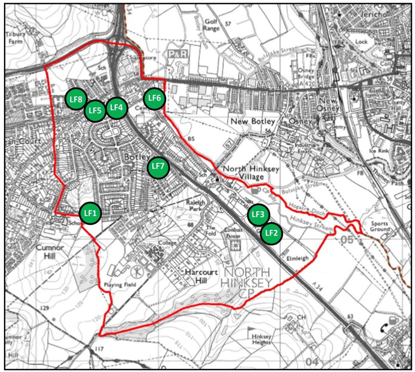
Map B.1: North Hinksey Conservation Area

6
Appendix C - Economy & Employment:
Sites for business use on maps C.1 (a) and C.1 (b):
CS1 - Botley Centre
CS2 - Seacourt Tower Retail Park
CS3 – Seacourt Tower
CS4 - Curtis Industrial Estate
CS5 - Hinksey Business Park
CS6 - Minns Business Park
CS7 – Richer Sounds (site of George PH)
CS8 - Raleigh Park Clinic site, 45 Raleigh Park Road
CS9 - Seacourt Bridge and surrounding business premises on north side of West Way
CS10 - Laburnum Road Convenience Store currently Lucky House, 49 Crabtree Rd
CS11 - McDonalds site and surroundings
CS12 - Travis Perkins / Enterprise site

Map C.1 (a) Sites for business use in North Hinksey Parish - overview

7
Map C.1 (b) Sites for business use in North Hinksey Parish – detail of main commercial area

8
Table C.1: Diversity of businesses in the Strategic Business Areas designated in the VOWHDC
Local Plan 2031 Part 1

 Curtis Industrial Estate
 Unit       Business                          Activity
          6 Always Easy Recycling Ltd         Scrap yard
        15 Api Computer Support Systems       PC Manufacturers
        14 Brookos Tyre & Exhaust Centre      Tyre fitting, wheel and exhaust repairs
        20 C R Marks Oxford Ltd               Motor Factors
        28 Catwalk Wholesale Ltd              Clothes & Fabric Wholesaler
        13 Chris Andrews Publications Ltd     Book Publishing
        36 Cooz's Records Ltd                 Recording Studio
        25 Edmundson Electrical Ltd           Electrical Wholesalers
        25 Electric Center                    Electrical equipment
          6 Eyejusters Ltd                    Adjustable close focus spectacles
                                              Suppliers to Refrigeration and Air Conditioning
       14 Fridge Spares Wholesale Ltd         trades
          M & J Auto Repair (North
          Hinksey Garage)                      Motor services
        2 Minty (Oxford) Ltd                  Beds, mattresses and storage
          Newey & Eyre                        Electrical Distributors
       17 North Hinksey MOT Centre            Vehicle Repair Shop
       12 Oxford Food Bank                    Foodbank
          Oxford Glass & Glazing Systems
          Ltd                                 Glass repairs & bespoke glass
    14-15 Oxford Picture Library              Film & Photographic Libraries
        5 S I Pumps Ltd                       Pump Sales & Servicing
          Southern Energy Products            Boiler / heating installation & repair
       15 Tyre Services Great Britain Ltd
                                              Plumbers: see also Plumb Center, Pipe Center
       35 Wolseley UK Ltd                     and Drain Center

 Hinksey Business Centre
           3TH Ltd                            Training
            Botley Road Motors                Motor services
            Bruce Butcher Electrical Ltd      Electrical services
            DCS Couriers                      Courier
            Elliot Brown Agency               Commercial Model Agency
            Key Agent                         Property management
            Natural Bread Company             Bakers & bread making courses
            Northgate Vehicle Hire            Van Hire

 Minns Business Park
            Dehns                             Patent Attorneys
9
Ogilvy 4D Ltd Medical industry consultants
Savills Real Estate Services
tci renewables Renewable Energy Consultants
Vicon Motion Systems Motion Capture Systems
Seacourt Retail Park
AKS Ward Construction Consultancy
Bidwells Ltd Property & Land Consultants
Blake Morgan Solicitors
Caudex Medical Pharmaceutical consultants
Cluttons Styles & Whitlock Chartered surveyors & property consultants
Focus Financial advisors & insurance consultants
Handelsbanken Bespoke banking services
Hartwell Ford BP Petrol Station Petrol Station
HM Courts & Tribunals Service Ministry of Justice agency
Homebase DIY supplies
Lambert Smith Hampton Commercial property consultants
McBains Cooper Property consultants
Oxford Outcomes Pharmaceutical consultants
10Appendix D - Transport:
Map D.1 – Bus routes through North Hinksey Parish and Central Oxford
11Map D.2 – cycle routes from North Hinksey Parish to Oxford City Centre 12
Appendix E - Social Infrastructure:

Maps of social infrastructure facilities and other locations of significant importance to the
community

Map E.1 leisure facilities and venues in North Hinksey Parish

Leisure

LF1 – Louie Memorial Playing Fields
(including Pavilion and Scout Hut)
LF2 – Oxford Rugby Football Club
LF3 – Oxford Sports Lawn Tennis Club
LF4 – Seacourt Hall
LF5 – SS Peter & Paul Church Hall
LF6 – The WI Hall
LF7 – The Rosary Room
LF8 – Hall in Seacourt Road

13
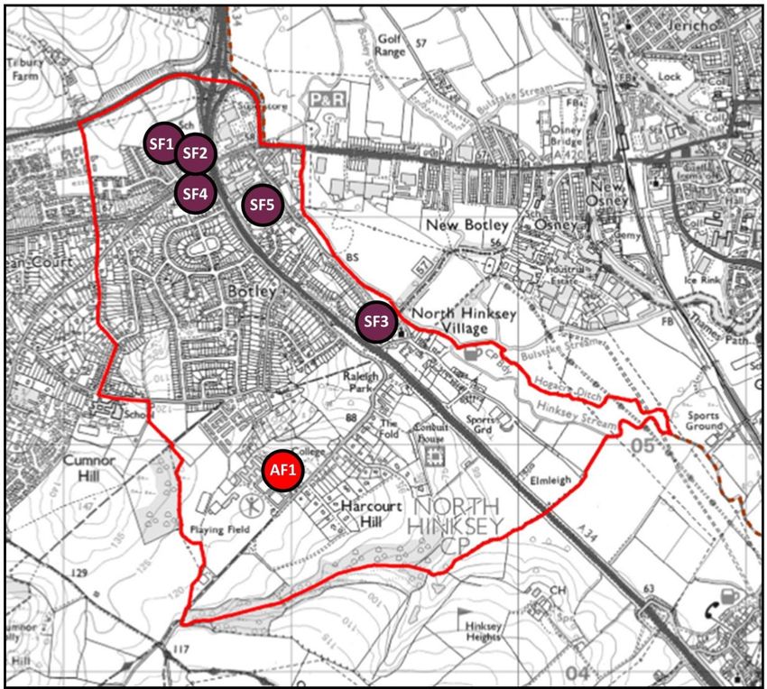
Map E.2: Social facilities (health facilities, educational facilities, libraries & cemeteries):

Social

SF1 – Elms Road Medical Centre
SF2 – Botley School
SF3 – North Hinksey School
SF4 – Botley Library
SF5 – Botley Cemetery

Academic with ancillary leisure

AF1 - Brookes University Harcourt Hill

14
Map E.3: Historic Buildings and Monuments, Churches, and other Miscellaneous Sites:
HM1 – St Lawrence’s Church (C of E)
HM2 – SS Peter & Paul Church (C of E)
HM3 – Botley Baptist Church
HM4 – Our Lady of the Rosary Church (R.C.)
HM5 – Elms Parade
HM6 – Commonwealth War Graves in Botley Cemetery

        Map E.3: historic sites and churches HM1 to HM6 In North Hinksey Parish

15
Appendix F - Utilities: Map F.1 showing a geological map of North Hinksey Parish (taken from the GWP Consultants Groundwater Assessment of North Hinksey Parish (July 2017) - Drawing 4) 16
Map F.2 showing the Zone of Potential Groundwater Flooding (taken from the GWP Consultants
Groundwater Assessment of North Hinksey Parish (July 2017) - Drawing 6)

17
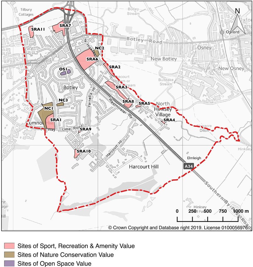
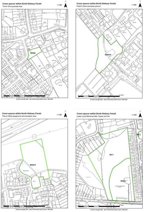
Appendix G – Green Spaces

Map G.1 Local Green Spaces within North Hinksey Parish:

      Sites of sport, recreation & amenity value (SRA)
      SRA1 – Lower Louie Memorial field
      SRA2 – Allotments on North Hinksey Lane
      SRA3 - Allotments between North Hinksey Lane and Southern Bypass Road
      SRA4 – North Hinksey Village Green
      SRA5 – St Lawrence’s Churchyard
      SRA6 - Botley Cemetery
      SRA7 – Botley Primary School playing fields

18
SRA8 – North Hinksey C of E Primary School playing fields
SRA9 – Turner Drive grassed area
SRA10 – Ruskin Close recreation ground
SRA11 – Tilbury Fields playground and recreation area
Sites of Nature conservation value: (NC)
NC1 - Lower Louie Memorial field copse and fen
NC2 - Nature Reserve & Community Orchard
NC3 - Chestnut Road copse
Sites of open space value
The grassed areas and verges designed into the Elms Rise estate and surrounding roads are
an important feature and contribute to its character. They add to the distinctive open feel,
enhance views over the surrounding countryside and reinforce the sense that you are in a
semi-rural area.
OS 1 - St Paul’s Crescent lawns
Please note: other areas were considered for inclusion as Local Green Spaces but not subsequently
adopted. These include areas within the Oxford Green Belt (e.g. the Upper Louie Memorial Playing
Field, Raleigh Park, and Hinksey Heights Nature Reserve), which already have the protection of
that designation.
The following pages show individual detailed maps of each of the 15 Local Green Spaces listed
above.
1920
21
22
23
Table G.1 The National Planning Policy Framework Green Spaces criteria applied to the green
spaces of North Hinksey Parish

 Location
                 NPPF Criteria 1:    NPPF Criteria 2: The designation should          NPPF Criteria 3: The
                 The designation     only be used where the green area is             designation should only
                 should only be      demonstrably special to a local community        be used where the
                 used where the      and holds a particular local significance, for   green area concerned is
                 green space is      example because of its beauty, historic          local in character and is
                 in reasonably       significance, recreational value (including      not an extensive tract of
                 close proximity     as a playing field), tranquillity or richness    land.
                 to the              of its wildlife.
                 community it
                 serves.

 Louie           The site is         The Fields have local historic significance:     The lower Louie
 Memorial        located within      the land was given by the Kingerlee family       Memorial Fields are
 Fields, Copse   the built up        to the Parish 1939 and is owned / managed        surrounded by built
 and Fen,        area of Botley /    by North Hinksey Parish Council for the          development on three
 Arnold’s Way    North Hinksey.      recreational use of Parishioners. And to this    sides and bounded by a
                 The Parish          day are used predominantly by                    road that bisects the
                 boundary            Parishioners, along with those who attend        original land into two
                 between North       the neighbouring school and live in the          sites. This is the largest
                 Hinksey and         neighbouring Parish of Cumnor.                   open space within the
                 Cumnor runs         The upper field is well-used for recreational    Parish and contributes
                 along the upper     facilities and community events. Its function    the only public site large
                 field’s SSW edge    as a recreational playing field was              enough to hold a full-size
                 adjacent to         augmented in 2010 by the addition of an          football pitch –an
                 Matthew Arnold      outdoor gym trail and an all-weather Multi-      amenity which is
                 School. The         Use Games Area (MUGA). Part of the field is      frequently in use both
                 Fields sit at the   a designated football pitch, which is used by    formally and informally.
                 top of Elms Rise    local teams and currently hired out in term-     The community uses and
                 estate.             time to the Secondary school in the              values the structured
                                     adjoining Parish. The Fields are a favourite     and unstructured
                                     site for community gatherings such as fetes.     recreation facilities that
                                     The sports pavilion is also used for regular     the fields, copse and fen
                                     meetings of local groups including the Youth     provide. The elevated
                                     Club and pop-up café events.                     site affords valued,
                                     The sloping Lower Field is busy all year         serene, long distance
                                     round: it has a well-used, secure designated     views across the north of
                                     play area for children up to the age of 10.,     Oxford and to Wytham
                                     the open field is much-used by those             Woods.
                                     exercising dogs or energetic children and
                                     hosts organised activities such as outdoor
                                     yoga and training.
                                     The copse and fen is a designated wildlife
                                     site crossed by well-used footpaths that
                                     allow access to this rare wild space to all
                                     from kids building dens to naturalists. The
                                     rare alkaline fen habitat is rich with a
                                     diverse range of wetland species, including
24
Flag Iris and Mares Tail. The area is also an
important wildlife corridor and many birds
nest here.
Nature The site is The Parish’s dedicated nature reserve was This site is surrounded
Reserve and located within created in 2003 – 2004 with the by buildings on three
Memorial the built up involvement of the local community who sides, including the
Garden & area of Botley / continue to tend it. The reserve includes a Minns industrial estate
Community North Hinksey wildflower meadow, two ponds and a more which gave the land
Orchard, in the northeast formal memorial garden that provides originally as allotments
North Hinksey of the Parish. space for quiet contemplation and (to which it could be
Lane reflection in a peaceful environment. Part of reverted if required).
the reserve has been planted with fruit The local community &
trees as a community orchard, open to the Parish Council created
public to enjoy the blossom and fruits. This and continue to care for
is a very inclusive, community-lead space the site. Many people
with benches and trees dedicated to local who live or work in the
people and organisations. The entire small vicinity enjoy the peace,
site benefits the community as green space and wildlife in the
infrastructure and the maintenance of the reserve. The orchard
pond and streams assist in alleviating fruit trees are the source
flooding in the wider locality. of the annual Botley
Apple Day celebrations
in October.
Allotments, The site is The allotments are managed by the NHPC These allotments (plots
North Hinksey located within Allotment committee. Tenancy is open to all 20-42) are sited on a
Lane the built up and many allotment tenants live within the narrow strip of land
area of Botley / Parish. This is one of only two allotment between the western
North Hinksey sites within the Parish and is popular and bank of Seacourt Stream
in the north- much valued. The maintenance of the site & and the northern end
eastern edge of individual plots contributes to flood North Hinksey Lane.
the Parish. alleviation in the wider locality.
Allotments The site is The allotments are managed by the NHPC These allotments (plots
between located within Allotment committee. Tenancy is open to all 43-119) are sited on a
North Hinksey the built up and many allotment tenants live within the narrow strip of land
Lane and area of Botley / Parish. This is one of only two allotment between the southern
Southern By- North Hinksey sites within the Parish and is popular and end of North Hinksey
pass Road in the northeast much valued. Lane and the Southern
of the Parish. Bypass Road. The site is
surrounded on four sides
by buildings and
provides a ‘green lung’
close to the busy A34.
St Paul’s The site is This is an open area that provides flexible The lawns were an
Crescent located within space for recreation and valuable green integral part of the
lawns the built up space for residents. There are several original 1930’s design of
area of Botley / venerable mature native trees in the lawns the Elms Rise estate.
North Hinksey which provide users with shade, the They are surrounded on
in the south of opportunity to climb trees and devise all sides by housing and
the Parish. outdoor games around them. The lawns are bisected by Finmore
of considerable local value: Crescent Road. The lawns provide
householders regard them as an essential both a safe open space
local amenity space and have fought off for recreation, and
applications to build on them over the past privacy as houses around
80 years. the Crescent are not
closely overlooked.
Chestnut The site is This small patch of land lies in the Elms Rise This site is of local value:
Road copse located within estate. It is rich in a diversity of wildlife: the site has remained
25the built up native trees and plants, birds, butterflies protected from
area of Botley / and mammals. There are legally protected development historically
North Hinksey species resident on this site, and it’s a whilst the Elms Rise
in the central significant and important link in the wildlife estate was designed
southwest of corridor between the Louie Memorial lower around it and now
the Parish. The field copse and Raleigh Park. Residents of surrounds it with
site lies on the the surrounding roads recognise and buildings and roads on
northern corner cherish the wildlife that find sanctuary here four sides. The estate
of Chestnut and and value the sylvan view that this benefits from this patch
Cedar Roads. miniature woodland provides. of historic wood / scrub
which speaks to the time
when the whole hillside
was farmland and
copses.
Botley The site is The site has civic significance: It is owned The cemetery covers
Cemetery, located within and operated by Oxford City Council and approximately 8 acres
North Hinksey the built up was dedicated under the Interments Act in between Old Botley and
Lane area of Botley / 1894. Since then has served both the local the A34. Mature trees
North Hinksey and wider communities. The cemetery has line paths to the chapel
in the north- historic significance: burials include 739 and around the site
eastern area of Commonwealth war graves and almost 70 boundaries, protecting
the Parish. war graves of other nationalities, who were the peaceful, reflective
casualties of the First and Second World space from the
Wars. It is the only purpose-built constantly busy and
Commonwealth War Graves Commission noisy A34 and linking the
cemetery in Oxfordshire and has green, leafy space to the
architectural features designed by Sir mature gardens along
Edward Maufe The cemetery is valued as a North Hinksey Lane and
place of quiet contemplation and the community orchard
remembrance. It is also a habitat for wildlife and nature reserve
including amphibians, birds and protected opposite it.
species of mammals.
North Hinksey The site is This land is of historic significance as the The diminutive village
Village Green located within traditional green around which the village green sits at the centre
the built up has grown. Its history is documented in of the North Hinksey
area of Botley / photographs taken by the renowned Oxford Village Conservation
North Hinksey photographer Henry Taunt in the early Area, in the centre of the
in the east of 1900s. Today it provides more than a link to village, and is the
the Parish, at the past, it’s a local recreation space used archetypal rural foil to
the centre of by the community for leisure, with a swing the surrounding 17th and
North Hinksey attached to one mature tree and a bench 18th Century thatched
village. from which views over the Seacourt Stream stone cottages.
and meadows are enjoyed. The village
green is registered as common land and
maintained by North Hinksey Parish Council.
Botley The site is This land has recreational value to the The whole school site
Primary located within community as a school playing field and site comprises approximately
School Playing the built up for outdoor activities that both the School 3 acres and its playing
Fields, Elms area of Botley / and wider society can benefit from. Botley fields run alongside the
Road North Hinksey. School playing fields lie in an area rich in A34 slip road and are
The school lies wildlife, the fields provide additional bounded by an arable
in the northern habitats and the school augments its field then the A420 to
area of the teaching with a Forest School area within its the north. The trees and
Parish. grounds. plants of the playing
fields mitigate some of
the air pollution from
the adjacent Botley
interchange.
26North Hinksey The site is This land has recreational value to the The school site
C of E Primary located within community as a school playing field and site comprises approximately
School playing the built up for outdoor activities that both the School 1.5 acres and its playing
fields, North area of Botley / and wider society can benefit from. The fields lie between North
Hinksey Lane North Hinksey playing fields provide part of a green Hinksey Lane and the
in the eastern corridor for flying species between the A34. The trees and
area of the floodplain meadows and Raleigh Park. plants of the playing
Parish. fields mitigate some of
the air pollution from
the adjacent A34.
Churchyard of The site is The churchyard wraps around the grade 2 The one acre site is
St Lawrence, located within listed 11th century church of St Lawrence, surrounded by roads and
North Hinksey the built up the Church of England Mother Church of the houses on three sides. It
Lane area of Botley / Parish. The site is of considerable local value sits proud of the
North Hinksey being the burial ground for generations of surrounding road height
in the east of local people including notable poets and by a metre, indicative of
the Parish in dignitaries after whom roads and parks in its long history as a
North Hinksey the Parish have been named. Burials include tended local burial
village.. one Commonwealth war grave, a casualty ground. The two large
of the first World War. The churchyard is yew trees by the
managed to encourage wildlife and is part Norman entrance to the
of a green corridor for flying species church also indicate the
between the floodplain meadows and great age of this site and
Raleigh Park. A public footpath winds the unbroken
through the high ground of neighbouring continuous use by the
gardens to reach the churchyard avoiding community.
floods, still used today and linking the past
village life to the present.
Turner Drive The site is This compact green space has been It is a small tract of land
recreation located within designed into the new housing estate to providing rare outside
area the built up provide a close accessible safe outside place space surrounded by
area of Botley / for recreation and peace. It was originally buildings and roads on
North Hinksey part of the garden of the neighbouring plot four sides, in a densely
in the south of and retains some of the original mature built new housing
the Parish. trees as well as a compact, open lawn area. development,
Ruskin Close The site is This land has recreational value to the This recreation ground
recreation located within community as a playground and a grassed provides open space in a
area next to the built up open space for outdoor activities. It densely built new
Brookes area of Botley / comprises a patch of grassland bisected by a housing development on
North Hinksey path and a small playground with rustic play what was largely open
in the south of equipment. This site lies adjacent to scrubland. The site is on
the Parish. Brookes University Harcourt Hill campus the edge of the Green
and encourages permeability of access from Belt and lies between
one development to the other, whilst Brookes University’s
delineating the end of the housing residential buildings and
development. housing .
Tilbury Fields Located at the This land has been allocated in plans for the The playground and
playground edge of the built new 140+ homes Tilbury Fields estate to limited recreation area
and up area of have recreational value to the community are sited at the edge of
recreation Botley / North as a playground and a grassed open space new housing estate,
area Hinksey in the for outdoor activities. At the time of writing, providing rare open
north of the it is yet to be constructed / landscaped. space at the edge of
Parish. dense housing.
27Map G.2 - locations rich in wildlife W1 - Hutchcombe Copse, fen and upper & lower Louie Memorial Fields W2 - Poplar, Hazel and Seacourt Roads and surrounding fields W3 - Chestnut Road copse, W4 - Raleigh Park W5 - North Hinksey Nature Reserve, W6 - Hurst Rise Road, W7 - The Garth W8 - Maple Close, W9 - St Paul’s Crescent The above ‘locations rich in wildlife’ were identified by parishioners during the consultation process and the list is not exhaustive. It should also be noted, for example, that within North Hinksey Parish there are three designated TVERC Local Wildlife Sites (40X01 Harcourt Hill Scrub LWS, 40X03 Raleigh Park LWS, and 40X05 Louie Memorial Fields LWS – see http://www.tverc.org for details), and in addition a small segment of the Oxford Heights West Conservation Target Area covers part of the southern fringe of the Parish (see https://www.wildoxfordshire.org.uk/wp- content/uploads/2014/12/Oxford-Heights-West-CTA.pdf for details). 28
Map G.3 - Known wildlife corridors in North Hinksey Parish

          WC2

                                   WC4

                         WC3

        WC1                              WC5

                   WC7

                                                  WC6

WC1 – Between gardens and roads into Hurst Rise Road and the lower Louie Memorial Field,
copse and fen
WC2 – Between the fields adjacent to the A420 and Hazel, Poplar and Elms Roads
WC3 – Between the lower Louie Memorial Field, copse and fen, linking to the copse at the west
end of Chestnut Road, and east through gardens and passageways to Raleigh Park
WC4 – Between Botley Cemetery and the North Hinksey Nature Reserve and Community Orchard
and along Seacourt Stream to the water meadows
WC5 – Numerous routes into and out of Raleigh Park from all directions
WC6 – Routes leading into and out of Hinksey Heights nature reserve
WC7 – Routes leading across Brookes’ playing fields and into farmland and copses
The above ‘wildlife corridors’ were identified by parishioners during the consultation process and
the list is not exhaustive. It should also be noted, for example, that within North Hinksey Parish
there are three designated TVERC Local Wildlife Sites (40X01 Harcourt Hill Scrub LWS, 40X03
Raleigh Park LWS, and 40X05 Louie Memorial Fields LWS – see http://www.tverc.org for details),
and in addition a small segment of the Oxford Heights West Conservation Target Area covers part
of the southern fringe of the Parish (see https://www.wildoxfordshire.org.uk/wp-
content/uploads/2014/12/Oxford-Heights-West-CTA.pdf for details).

29
North Hinksey’s valued views (as collected at the public consultation events)
North Hinksey Parish residents value the views within, from and to the Parish which benefits from
being surrounded on three sides by countryside and on the fourth by the historic city of Oxford. The
appeal, worth and importance of the Parish’s setting and views has been documented in the Botley
Character Statement (January 2018). Following the responses received from the Neighbourhood
Plan public consultations about the specific views that Parishioners value, the Green Spaces and
Natural Environment Working Group have undertaken an assessment of those views, to evaluate
their importance for protection under the Neighbourhood Plan.
This assessment follows the methodology devised by Bredon Parish Council and Neighbourhood
Plan Group, (described in full at
https://www.wychavon.gov.uk/documents/10586/0/Assessment+of+Key+Views+in+Bredon+Parish
+%28February+2017%29.pdf/e86151b5-aba8-d85b-859a-dc66843ed343_/)
The North Hinksey Green Spaces and Natural Environment Working Group have gratefully used this
methodology with the intention to apply a generic, standardised approach that minimises
subjectivity.
Table G2: North Hinksey Views Assessment Grid should be read with the following notes (further
detail is given in the Assessment of Key Views in Bredon Parish document):
• Viewpoints are listed by reference number which is used consistently on the accompanying
Map G4 and photographs. The viewpoints are all on public land or private land which is
publicly accessible.
• Natural England have published a country-wide landscape character assessment that divides
England into 159 National Character Areas:
http://publications.naturalengland.org.uk/publication/5431100?category=587130. North
Hinksey Parish lies wholly within NCA 109: the Midvale Ridge “a band of low-lying limestone
hills stretching east–west from the Vale of Aylesbury in Buckinghamshire to Swindon. It is
surrounded by the flat lands of the Oxfordshire clay vales, giving extensive views across the
surrounding countryside.”
Grading the importance of views:
• Views have been graded as either ‘exceptional’, ‘special’ or ‘representative.’
• Exceptional views might include highly valued, panoramic views or long distance views
across intact countryside; they might capture the quintessential character of an area; they
might contribute to the enjoyment of important heritage or cultural locations; or they might
be unique in their own way.
• Special views might include panoramic or long distance views, dramatic scenery and skyline
features; they might help to reveal landscape character types; or they might be comparable
to other special views.
• Representative views might include narrow or glimpsed views; they might be marred by the
presence of negative features which detract from the quality of the experience; or they
might be typical views which are replicated elsewhere.
30Map G.4 North Hinksey’s valued views (as collected at the public consultation events)
VP15
31Viewpoint 1: From Raleigh Park down to North Hinksey village & on towards Oxford Viewpoint 2: From the corner of Sweetmans Road & Raleigh Park Road towards Oxford Viewpoint 3: From Harcourt Hill Fields towards Oxford and south Oxfordshire 32
Viewpoint 4: From North Hinksey Lane towards the lines of trees along Seacourt Stream

Viewpoint 5: From Louie Memorial Fields over Port Meadow towards north Oxford and beyond

Viewpoint 6: From the top of Crabtree Road north to Wytham Woods, Port Meadow and North Oxford

33
Viewpoint 7: From Hurst Rise Road towards Wytham Woods and the fields below

Viewpoint 8: From the north and west side of the hill towards Tilbury Farm and fields above it

Viewpoint 9: From Louie Memorial Fields west to Wytham Woods

34
Viewpoint 9: From Louie Memorial Fields north to Seacourt Tower and Port Meadow

Viewpoint 10: From St Paul’s Crescent north towards Wytham Woods

Viewpoint 11: From the top road into Brookes’ campus towards Cumnor Hurst and Boars Hill

35
Viewpoint 12: From Poplar Road looking over Elms Parade and up Elms Rise estate hillside and a view from
Hazel Road looking towards a wider aspect of Elms Rise and the hillside

36
Viewpoint 13: From the bridleway towards Hinksey Heights, Boars Hill and south of Oxford

Viewpoint 14: From North Hinksey Village Green north through the village

Viewpoint 15: From the footpath between Wytham View and Hazel Road eastnortheast

37
Table G2: North Hinksey views assessment grid
 Map ref   Location of view       Landscape   Altitude   Type of view        Number & type of         Direc-
 of view   point                  character   of view    point               view point users         tion of
 point                            of view     point                                                   view
                                  point
 VP1       Raleigh Park           NCA 109:    99m        Historic/           Few; walkers /           E
                                  Midvale                Established         runners, dog
                                  Ridge                  viewpoint /         walkers, other
                                                         recreational        pedestrians
 VP2       Corner of              NCA 109:    94m        Movement            Few; vehicles,           ESE
           Sweetmans &            Midvale                corridor (road)     pedestrians, cyclists
           Raleigh Park Roads     Ridge
 VP3       Harcourt Hill Field,   NCA 109:    108m       Historic /          Few; dog walkers,        E to S
           south side of          Midvale                recreational        other pedestrians,
           Grosvenor Road         Ridge                                      residents
 VP4       North Hinksey Lane     NCA 109:    58m        Movement            Moderate; vehicles,      E
                                  Midvale                corridor (road &    pedestrians, cyclists
                                  Ridge                  cycle path)
 VP5       Louie Memorial         NCA 109:    118m       Recreational /      Moderate; vehicles,      NNE
           Fields looking north   Midvale                movement            pedestrians, cyclists,
                                  Ridge                  corridor (road)     bus passengers,
 VP6       Junction of Chestnut   NCA 109:    100m       Movement            Moderate; vehicles,      N, NW,
           & Crabtree Roads       Midvale                corridor (road /    pedestrians, cyclists,   NE
                                  Ridge                  bus route)          bus passengers,
 VP7       Hurst Rise Road        NCA 109:    121m       Movement            Moderate; vehicles,      N
           junction with          Midvale                corridor (road)     pedestrians&
           Arnold’s Way           Ridge                                      cyclists, bus
                                                                             passengers,
 VP8       Junction of Toynbee    NCA 109:    97m        Movement            Few; vehicles,           N
           Close and              Midvale                corridor (road)     pedestrians, cyclists
           Hutchcomb Road         Ridge
 VP9       Louie Memorial         NCA 109:    118m       Recreational /      Moderate; vehicles,      N, NW,
           Fields looking north   Midvale                movement            pedestrians&             NE
           and west               Ridge                  corridor (road)     cyclists, bus
                                                                             passengers,
 VP10      St Paul’s Crescent     NCA 109:    69m        Movement            Moderate; vehicles,      N
           (East side, junction   Midvale                corridor (road /    pedestrians& cyclists
           with Finmore Road)     Ridge                  bus route)
 VP11      Road into Brookes’     NCA 109:    119m       Movement            Moderate; vehicles,      W
           Sport (Privately       Midvale                corridor (road on   pedestrians,
           owned, publicly        Ridge                  University          students, gym &
           accessible road)                              grounds)            sports facility users
 VP12      Poplar Road            NCA 109:    62m        Movement            Few; vehicles,           S
                                  Midvale                corridor (road)     pedestrians& cyclists
                                  Ridge
 VP13      Bridleway west from    NCA 109:    119m       Movement            Few; vehicles,           S / SW
           top of Harcourt Hill   Midvale                corridor (public    pedestrians              / SE
                                  Ridge                  bridleway)          equestrians
 VP14      North Hinksey          NCA 109:    62m        Historic heritage   Moderate; vehicles,      N
           village green          Midvale                / movement          pedestrians& cyclists
                                  Ridge                  corridor (road)
 VP15      Footpath between       NCA 109:    76m        Movement            Few; pedestrians,        N / NE
           Wytham View and        Midvale                corridor            cyclists
           Hazel Road             Ridge                  (footpath)

38
Map ref Location of Description of view Key components of Psychological Importance of
of view view point view experience of view view
point
VP1 Raleigh Park Elevated; framed by Green hillside park in Sense of awe at Exceptional. It
vegetation in foreground drops the beauty of the is one of the
foreground, opening away to the iconic ‘dreaming spires’ viewcones
to dominant view of ‘dreaming spires’ surrounded by the defined by
historic cityscape in views of Oxford, calming, spacious Oxford City
middle ground, nestled under green green setting. Council /
framed in distance hills that mirror the Oxford
by vegetation on park. Preservation
hills of skyline. Trust/ Natural
England.
VP2 Corner of Elevated, open, wide The iconic ‘dreaming The suburban Special.
Sweetmans skies. Historic spires’ views of Oxford setting makes the
& Raleigh cityscape in middle are detracted by sudden views over
Park Roads distance framed by lampposts and Oxford city an
built development in warehouse buildings unexpected,
foreground. most obvious in breath-taking
winter. surprise.
VP3 Harcourt Elevated view over Views of historic A historic view, Exceptional
Hill Field, historic city across cityscape to the captured from
south side treetops and spires north-east partially nearby by JMW
of to the wooded hills hidden by mature Turner in 1835-40
Grosvenor in the east and over trees. The views to in ‘Oxford, from
Road fields & the the south are of open North Hinksey’.
southern edge of countryside It’s an impressive
Oxford and beyond punctuated by pylons & interesting view
to the Chilterns to & the A34 & some today, providing
the south. larger buildings in the new perspective
distance. on the city.
VP4 North Open, dominant Mature willow trees In full leaf, this Representative
Hinksey vegetation in the line the banks of the view is calming, – as the view
Lane foreground of view Seacourt Stream peaceful and changes with
(trees) which shields making an attractive tranquil. The view the seasons it
the industrial view between Spring of warehouses moves from
warehouses in the & autumn. When the does not inspire being special
middle distance. leaves fall, the view the same (leaf cover) to
over fields opens up beneficial less attractive
to warehouses filling reactions in the in winter.
the skyline behind. residents.
VP5 Louie Panoramic, elevated Recreational fields in Users report that Special.
Memorial views of open skies the foreground, built the view gives
Fields and rural land structures including them a feeling of
looking stretching to a far the A34 / A420 relaxation, peace,
north horizon. Framed by junction in middle of space and calm
vegetation with little ground. The far being surrounded
built development distance includes the by the countryside.
visible. Little green swathe of Port
seasonal change. Meadow & landscape
to the horizon.
39Map ref Location of Description of view Key components of Psychological Importance of
of view view point view experience of view view
point
VP6 Junction of Elevated, spacious In the foreground, the Significant for the Representative
Chestnut & views over Elms Rise housing estate drops openness of the / special in
Crabtree estate with Wytham away down the skies above the terms of
Roads woods on the hillside with local regular, encapsulating
western skyline and landmark Seacourt descending the distinctive
rural land to the Tower to the east. In housing. The characteristics
north. Vast open the middle ground, elevation & of the estate.
skies. Little seasonal Wytham woods rise in exposure adds to
change. front of north Oxford. the spaciousness
Pylons & wires are designed into the
mild detractors. estate’s layout.
VP7 Hurst Rise Contained views Residential housing Sense of a quiet, Representative
Road down the developed and gardens, Wytham calm, residential
junction residential road, woods, sky. Parked space opening to a
with leading to a distant cars, telegraph poles vista of impressive
Arnold’s view of Wytham and wires are mild wide skies.
Way Woods and up to detractors.
wide, open skies.
VP8 Junction of Broad views down Near residential The large front Special
Toynbee the developed housing is set well gardens &
Close and residential road, back in gardens. impressive vista of
Hutchcomb with a densely-built Wytham woods, & the wide skies above
Road new estate in the sky dominate the wooded hillside
middle ground and view. A detraction is give a sense of
fields leading up to the crowded chaotic space & distance.
Wytham Woods on look of the new The large skies &
skyline. Tilbury Fields estate. elevation create a
seaside aspect.
VP9 Louie As VP5: panoramic, Recreational fields & As with VP5, users Special
Memorial elevated views of copse in the report that the
Fields open skies , framed foreground with view gives them a
looking by vegetation. Some arable fields climbing feeling of
north and built development up to Wytham Woods relaxation, peace,
west visible, characteristic forming skyline to the of space and calm
of the Parish. Little west. In the northern being surrounded
seasonal change. middle ground sits the by the countryside.
locally iconic Seacourt
Tower.
VP10 St Paul’s Local view across Spacious green lawns Exemplary scene Representative
Crescent the lawns of St with mature trees encapsulating / special in
(East side, Paul’s Crescent, over edged with the ideals of the terms of
junction the residential hipped-roof houses original 1930’s encapsulating
with rooftops and 1960’s typical of the Elms estate: generous the distinctive
Finmore Westway Tower to Rise estate. Low-rise lawns create sense characteristics
Road) Wytham Woods on buildings allow the of openness and of the estate.
the skyline. hillside beyond and safety whilst the
wide skies to be seen wooded hillside to
throughout the year, the north alludes
though partially to the closeness of
hidden by leaves in rurality amidst
summer. suburbia.
40Map ref Location of Description of view Key components of Psychological Importance of
of view view point view experience of view view
point
VP11 Road into Long view across Green, open Glorious nature Special
Brookes’ Brookes’ University countryside and vast tamed and wild.
Sport Harcourt Hill skies. The tended The unbroken
(Privately campus playing sports pitches in the green covering
owned, fields, bounded by foreground reaches up to a
publicly trees to the wooded complement the low horizon. The
accessible Boars Hill to the densely wooded hills eye is drawn along
road) southwest, the that rise behind them. and up to huge
wooded Cumnor western skies that
Hurst to the display stunning
northwest. sunsets.
VP12 Poplar Road Local view down this Edwardian housing in A view that defines Representative
(alternative private road, to the the foreground. The this part of the / special in
views in the 1930’s Elms Parade 1930’s shopping Parish: suburban terms of
same of shops, then up parade and housing with many encapsulating
direction the hillside across estate dominate the elements of the distinctive
can be seen the rooves of the middle-ground & original 1930’s characteristics
from Hazel Elms Rise estate background. The busy built environment of the estate.
Road and dotted with mature West Way road and design, enhanced
Murdoch trees and planting. some of the late 20th by greenery and
Place) century buildings are colour from the
dectractors. gardens rising up
the hillside.
VP13 Bridleway Long sweeping The whole of this An archetypal view Special
west from views over horse- section of the of Oxfordshire
top of grazing fields, a golf bridleway offers wide mixed-use
Harcourt course and the ridge or glimpsed views countryside. The
Hill of Boars Hill and across grazing pasture pastures and
beyond to southern in the foreground; gentle rolling hills
Oxford, with the Hinksey Heights give a feeling of
Ridgeway path nature reserve and calmness and
visible on the south- golf course with mixed spaciousness
eastern horizon. planting and enhanced by the
occasional houses on wide skies and
Boars Hill in the song of skylarks
middle-ground and and cuckoos in
the sweeping vista Spring and
that opens across the summer.
Thames valley to the
Chiltern Hills.
VP14 North Short view north In the foreground are Very attractive Exceptional
Hinksey from the village some of the 17th & view within this
village green along North 18th century stone unique, historic,
green Hinksey village cottages that lie serene part of the
towards the public within the North Parish. The
House (The Fishes). Hinksey village thatched dwellings
Conservation area. surrounded by
The history, ambience green verges and
& distinctiveness of cottage gardens
the village are create a timeless,
encapsulated. tranquil feel.
41Map ref Location of Description of view Key components of Psychological Importance of
of view view point view experience of view view
point
VP15 Footpath Short view north Pylons & the A34 in A strong sense of Representative
between across arable field to the foreground being on the edge
Wytham tree-line, Long view detract from the long of the city, and
View and east across rooves & view of parts of the close to the
Hazel Road the city is historic cityscape and surrounding
punctuated by surrounding wooded countryside – a
pylons & the hills. view from a liminal
Seacourt Tower. place .
42Appendix H: Oxford Brookes University, Harcourt Hill Campus
Map H.1 – Harcourt Hill Campus major development site boundary
(map produced by Oxfordshire County Council)
43You can also read