NORTH ISLAND MANAGEMENT PLAN SUMMARY 2020/2021 - Ernslaw ...
←
→
Page content transcription
If your browser does not render page correctly, please read the page content below
NORTH ISLAND
MANAGEMENT PLAN
    SUMMARY

     2020/2021

                  Page | 1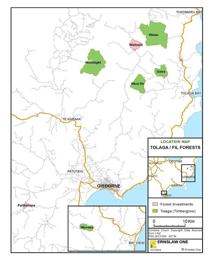
CONTENTS
1 INTRODUCTION ........................................................................................................... 4
2 COMPANY PROFILE .................................................................................................... 4
3 MANAGEMENT OBJECTIVES ..................................................................................... 5
4 FOREST RESOURCE ..................................................................................................... 5
5 SPECIES AND SILVICULTURE ..................................................................................... 8
6 HARVESTING ............................................................................................................... 8
7 WOODFLOW ................................................................................................................ 9
8 MAINTENANCE AND PROTECTION ........................................................................... 9
9 FOREST GROWTH AND DYNAMICS ........................................................................ 10
10 ENVIRONMENTAL PERFORMANCE ......................................................................... 11
11 CARBON FORESTRY .................................................................................................. 13
12 INDIGENOUS FLORA AND FAUNA ........................................................................... 13
13 EMPLOYMENT SUMMARY ........................................................................................ 14
14 OTHER FOREST USES ............................................................................................... 15
15 COMMUNITY INVOLVEMENT .................................................................................. 15
16 GISBORNE FORESTS .................................................................................................. 17
17 TOKOMARU AND MATA FORESTS .......................................................................... 18
18 MANGATU AND WAIPAOA FORESTS ...................................................................... 19
20 TIMBERGROW NORTH ISLAND FORESTS (TOLAGA FORESTS) ........................... 22
22 RANGITIKEI SANDS FORESTS.................................................................................. 25
23 RANGITIKEI HILLS FORESTS ................................................................................... 27
24 TE NAMU FOREST .................................................................................................... 28
25 TITOKI FOREST......................................................................................................... 29
26 KUMEROA FOREST.................................................................................................... 30
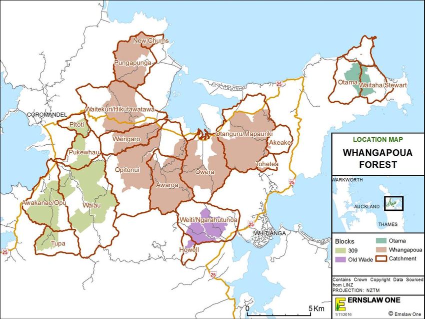
27 WHANGAPOUA FOREST ........................................................................................... 32
28 CONTACT DETAILS................................................................................................... 34
29 KARIOI FOREST ......................................................................................................... 35
30 WAIMARINO FOREST ............................................................................................... 37
31 CONTACT DETAILS................................................................................................... 38
FIGURES
FIGURE 1: ERNSLAW ONE LTD. NORTH ISLAND FOREST LOCATION MAP ..................................................................................... 16
FIGURE 2: ERNSLAW ONE LTD. GISBORNE FOREST LOCATION MAP ............................................................................................. 21
FIGURE 3: TGL TOLAGA FORESTS LOCATION MAP ..................................................................................................................... 24
FIGURE 4: ERNSLAW ONE LTD. SOUTHERN NORTH ISLAND FOREST LOCATION MAP ................................................................... 31
FIGURE 5: ERNSLAW ONE LTD WHANGAPOUA FOREST LOCATION MAP ...................................................................................... 34
FIGURE 6: ERNSLAW ONE LIMITED SOUTHERN NORTH ISLAND FORESTS, RUAPEHU FORESTS ..................................................... 39
TABLES
TABLE 1: NORTH ISLAND ESTATE AREA SUMMARY AS AT 30TH JUNE 2020 .................................................................................... 7
TABLE 2: STAFF AND CONTRACT CREWS EMPLOYED BY ERNSLAW AND TGL .............................................................................. 14
TABLE 3: GISBORNE FORESTS AREA SUMMARY AS AT 31ST DECEMBER 2019............................................................................... 17
TABLE 4: GISBORNE FORESTS SUMMARY OF OPERATIONS 2019/20 ............................................................................................. 21
TABLE 5: TGL NORTH ISLAND FORESTS AREA SUMMARY AS AT 31ST DECEMBER 2019 ............................................................... 22
TABLE 6: TGL FORESTS SUMMARY OF OPERATIONS 2019/20 ..................................................................................................... 23
TABLE 7: RANGITIKEI SANDS FORESTS AREA SUMMARY AS AT 31ST DECEMBER 2019 ................................................................. 25
TABLE 8: RANGITIKEI SANDS FORESTS SUMMARY OF OPERATIONS 2019/20 ............................................................................... 26
Page | 2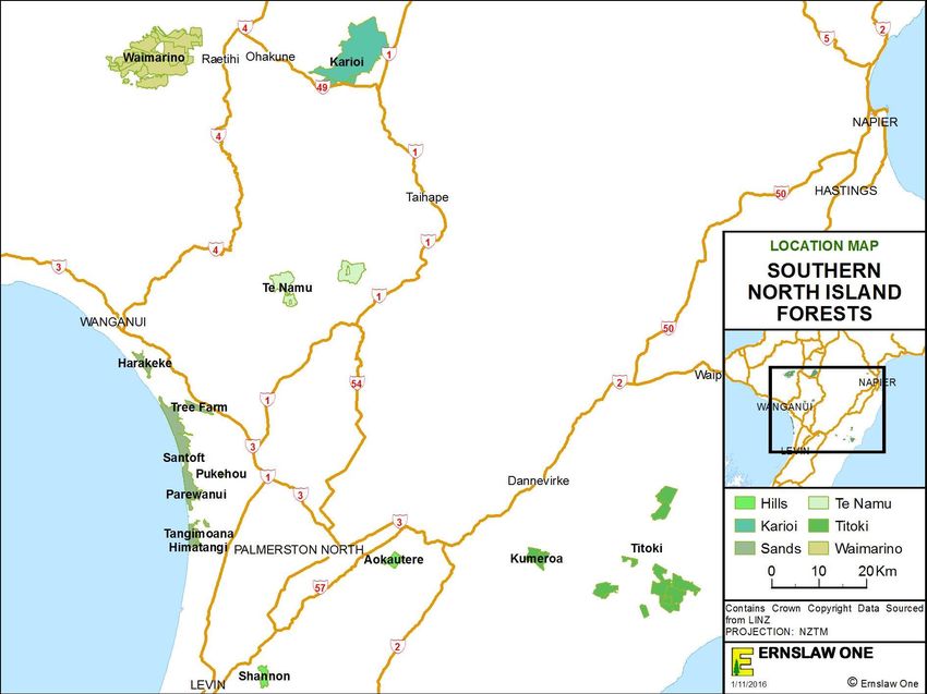
TABLE 9: TITOKI FORESTS SUMMARY OF OPERATIONS 2019/20 .................................................................................................. 30
TABLE 10: WHANGAPOUA FOREST SUMMARY OF OPERATIONS 2019/20 ...................................................................................... 33
TABLE 11: KARIOI FOREST SUMMARY OF OPERATIONS 2019/20 ................................................................................................. 36
TABLE 12: WAIMARINO FOREST AREA BY LAND TENURE AS AT 31ST DECEMBER 2019 ................................................................ 37
TABLE 13: WAIMARINO FOREST SUMMARY OF OPERATIONS 2019/20 ......................................................................................... 38

                                                                                                                                                Page | 3
1   INTRODUCTION
This document is a summary of the Ernslaw One Limited (Ernslaw) Management Plan for the
North Island estate which is certified by the Forest Stewardship Council® (FSC®)
(FSC®C010424). FSC® certification is an internationally recognised standard that
demonstrates how a company’s forests are managed in an environmentally sound, socially
beneficial, and economically viable manner. Ernslaw certification was granted through
measurement of its operations and practices against the principles and criteria developed by
FSC® which define well managed forests.

Principle 7 requires Ernslaw to develop a management plan.

Principle 10 requires Ernslaw to explicitly state in the management plan the management
objectives of the plantation, including natural forest conservation and restoration objectives,
which are clearly demonstrated in the implementation of the plan.

The Principles state:

Principle 7: Management Plan - A management plan, appropriate to the scale and intensity of
operations-shall be written, implemented, and kept up to date. The long-term objectives of the
management, and the means of achieving them, shall be clearly stated”

Principle 10.1.1: Objectives of tree planting shall be explicit in the management plan, with
clear statements regarding the relationship between tree planting and the silviculture,
socioeconomic and environmental (i.e. forest conservation and restoration) realities in the
region.

Principle 10.1.2: Management objectives for conservation of natural forest and restoration shall
be described in the management plan.

Principle 10.1.5: Plantation management objectives, including explicit measures under Criteria
6.2, 6.3, 6.4, 6.9, 6.10, 10.2 and 10.5 intended to maintain and retain indigenous biodiversity,
are identified in the management plan and implemented in a timely manner.

Principle 10.1.6: The management plan shall identify the boundaries of the area encompassed
by the certificate, which includes the plantation forest plus any designated reserve areas.

This document is in fulfilment of Principle 7 and the relevant criteria of Principle 10. The first
part of this document describes the higher-level policies for the North Island estate. The second
part details the management plan of each forest under the Ernslaw Certificate SGS-FM/COC-
000905.

2   COMPANY PROFILE
Ernslaw is a private company, registered in New Zealand, with its owners based in Malaysia.
The company was established in 1990 when it purchased several Crown Forestry Licences
(CFL) of state forests from the government, as well as a sawmill. The company has since
bought more forests and more land which has been converted to forestry. In 2011 a private
company Timbergow Ltd (TGL) acquired forest estate in the North Island. Ernslaw entered
into an agreement to manage this estate for TGL. These forests are referred to as the Tolaga

                                                                                           Page | 4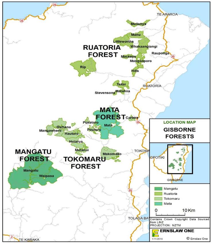
Forests. In 2017 a private company, Forestland Investments Ltd (FIL) acquired forest land in
the Gisborne district - this is managed by Ernslaw on behalf of the owners.
Contacts for key offices are below:

 Head Office                                    North Island and Gisborne Regional Office
 Private Bag 92826                              PO Box 2042
 Penrose                                        Gisborne
 Auckland                                       Ph:(06) 867 9179
 Ph:(09) 622 2080                               Fax:(06) 863 1011
 Fax:(09) 622 2191

3   MANAGEMENT OBJECTIVES
Ernslaw is committed to creating sustainable softwood forests and delivering premium
quality appearance grade wood and panel board products for export and domestic customers.

Ernslaw has demonstrated its commitment to forestry in New Zealand by reinvesting
company earnings back into the New Zealand operation, as well as investing further capital.
This commitment has seen the New Zealand forest area to increase from the 23,987 hectares
purchased in 1990 to an area of 110,118 stocked hectares as at 30 June 2020 (including both
North Island and South Island). In addition to this is the 14,570 hectare forest estate managed
on behalf of TGL, and the land holding of FIL.

4   FOREST RESOURCE
The North Island forest estate under certificate SGS-FM/COC-000905 is spread throughout the
North Island. The North Island is split into two regions of management; Gisborne (based out
of the North Island regional office in Gisborne, Regional Manager Bill Wheeler), and Southern
North Island (based out of Bulls, Regional Manager Steve Couper). The two regions report to
the Chief Executive Officer, Paul Nicholls based in Auckland.

Forest blocks more distant from the regional offices have an office from which forestry and
harvesting operations are managed; this includes the Karioi office and Whangapoua office. The
North Island estate comprises the three following forest regions:

        Coromandel                        Gisborne                Southern North Island
    •   Whangapoua forest           •   Ruatoria forest            • Karioi forest
                                    •   Tokomaru forest            • Waimarino forest
                                    •   Mata forest                • Te Namu forest
                                    •   Mangatu forest             • Titoki forest
                                    •   Timbergrow forests         • Kumeroa forest
                                    •   Forestland forests         • Rangitikei Sands
                                                                   • Rangitikei Hills

Ernslaw has entered into management agreements with two forest companies, namely
Timbergrow Ltd and Forestland Investments Ltd. The resource of both these companies form
part of the forest management unit making up the certification area for Ernslaw. The tree crop
currently on the land owned by Forestland Investments Ltd is currently being harvested through
PF Olsen Ltd and managed under a forestry right. Once harvested, direct management of the
land is taken over by Ernslaw.

                                                                                        Page | 5
The table over page gives a summary of the areas managed by Ernslaw and the tenure status of
each forest (North Island estate). (Note; the total productive area detailed in this document
includes the current stocked area, plus areas awaiting restocking.)
Page | 6Table 1: North Island estate area summary as at 30th June 20
Forest Region Forest Tenure Total Area Total
(ha) Productive
Area (ha)
Coromandel Whangapoua CFL 10,581 7,901
Gisborne Ruatoria CFL 11,547 8,665
Tokomaru CFL 7,323 6,241
Mata Freehold 7,973 5,900
Mangatu CFL 12,630 9,287
Leasehold 3,527 2,161
Southern North Karioi CFL 11,068 9,213
Island Waimarino Freehold 3,918 2,652
Leasehold 10,203 5,063
Te Namu Freehold 3,772 2,830
Titoki Freehold 8,397 7,281
Kumeroa Freehold 1,079 944
Rangitikei Sands CFL 1,752 1,434
Leasehold 3,556 2,896
Freehold 370 338
Tree Farm Freehold 461 418
Rangitikei Hills Freehold 1,693 1,097
Total Ernslaw North Island 99,452 74,024
Total Ernslaw South Island 30,928 25,664
Total Ernslaw New Zealand 130,380 95,352
TGL North Island 13,119 9,467
TGL South Island 6,164 4,791
Total TGL New Zealand 19,285 14,280
Forestland Investment 1,135 917*
*area replanted and currently under Ernslaw One Ltd management
Crown Forestry Licences (CFL’s) are agreements in which the Crown and forest companies
enter into purchase of cutting rights for a defined area. The company has the right to harvest
the trees at maturity and then replant the land subject to the conditions within the licence
agreement and Regional Council resource consents. The Crown continues to own the land and
is paid an annual rental.
Much of the CFL land under Ernslaw management is subject to Treaty of Waitangi claim and
may be returned to Maori land owners as part of any settlement agreement. The Ruatoria and
Tokomaru forest land has been returned to Maori ownership under the Ngati Porou Claims
Settlement Act 2012. Ngati Porou intend to increase their interest in forestry, and as such will
Page | 7obtain cleared land as Ernslaw concludes harvest operations and re-establish the land
themselves. This means the Ruatoria and Tokomaru forest areas under Ernslaw management
are diminishing each year as a result of this process.
Parts of Santoft and Lismore Sands (Harakeke Forest) have been returned to Ngati Apa with
the signing of the Ngati Apa Claims Settlement Act 2010. While a couple of areas are
earmarked for conversion to pastoral land uses Ngati Apa are yet to fully determine what
involvement, if any, they are likely to have in forestry.
With the passing of the Ngati Tuwharetoa Settlement Act 2018, an area of 952 hectares
within Karioi Forest was transferred from the Crown to Ngati Tuwharetoa. It wasn’t until
nearly a year later with the passing of the Ngati Rangi Claims Settlement Act in August of
2019, that the remaining land area of Karioi Forest was transferred from the Crown to Ngati
Rangi ownership.
5 SPECIES AND SILVICULTURE
5.1 POLICY
The North Island estate focuses on growing radiata pine.
5.2 METHODS OF IMPLEMENTATION
Approximately 90% of the certified productive area is stocked with radiata pine. This species
has been proven to grow successfully in New Zealand and performs extremely well compared
to other species. It can be grown on a wide range of sites, has minimal associated pests and
diseases, and when purchasing land, the company has selected areas that are suitable for radiata
pine.
Ernslaw mostly establishes improved controlled pollinated (CP) radiata pine tree stock and
occasionally will establish small areas using lower quality open pollinated tree stock. CP stock
results in faster growth, increased volume and enhanced wood properties at harvest time. The
target stocking for planting is 1000 stems/hectare across all sites. The processes, regimes and
other operational guidelines are detailed in the Ernslaw Establishment and Silviculture Manual.
The manual has been reviewed and an updated version made available in February 2018. This
manual is a ‘dynamic’ document, which is subject to periodic updates as required. The most
recent was including guidance on the topic of the National Environmental Standard for
Plantation Forestry (NES-PF)
6 HARVESTING
6.1 POLICY
Production forest harvesting is undertaken in an economically, environmentally and socially
sustainable basis with safety as a primary focus.
6.2 METHOD OF IMPLEMENTATION
Harvesting includes both production thinning (carried out in the Rangitikei Sands forests and
Karioi forest) and clearfell harvest of mature stands. Harvesting is carried out by contractors
using a mixture of ground based and hauler techniques, depending on the terrain.
Page | 8The detailed process of harvest planning is described in the Ernslaw Harvesting Manual. A
harvest plan is written which describes the method by which timber will be safely harvested
and transported from a forest area with minimal environmental impact. Topography, landing
requirements, design, location, and spacing of roads and landings, environmental constraints,
statutory and voluntary compliance requirements must be analysed, balanced and considered
in order for harvesting operations to occur with maximum efficiency and minimal disturbance.
Forest management software tools are used to analyse various scenarios in order to select the
optimal harvesting layout for any given cut plan area.
7 WOODFLOW
7.1 POLICY
The company has two general regimes for growing radiata pine; clearwood and panel-board.
In addition to this is a small amount of pulp taken from production thinning’s and clearfell.
1. The clearwood regime focuses on producing pruned clearwood for appearance end
uses. Pruning is done in 2-3 lifts and aims to produce a pruned butt log of at least 5.2
m with sawlogs above that.
2. The panel board regime aims to produce a structural grade log with small branching
that could be used in the production of plywood and other panel board products.
These regimes vary slightly between forests, as they have been customised for the local site
conditions.
7.2 METHODS OF IMPLEMENTATION
Ernslaw’s current sustainable harvest levels will vary among forests over time due to differing
age classes. The annually produced Estate Plan will define these levels. The Estate Plan and
harvest volume is determined using Remsoft Spatial Planning System (Woodstock), a spatial
linear programming tool.
Harvest volumes will increase around the year 2025 when new forests established in the
Southern North Island and Gisborne reach maturity and harvesting commences.
Currently around 30% of the Ernslaw North Island volume is sold domestically, with Ernslaw
supplying logs to up to ten domestic sawmills and three pulp and paper mills in the North
Island. The remaining 70% is exported in log form. The primary export destination is China.
100% of the TGL harvested volume is exported.
8 MAINTENANCE AND PROTECTION
8.1 POLICY
1. To actively participate in rural fire committees.
2. To control pest animals and pest plants in accordance with the Integrated Pest
Management Strategy, District Council Regional Pest Management Strategy and
Animal Health Board requirements.
Page | 98.2 METHODS OF IMPLEMENTATION
Ernslaw maintains its own fire-fighting equipment (including fire engines) and has its own
fire stores. Ernslaw staff are trained in a variety of fire related roles including operations,
planning and logistics to combat forest fires.
Up to the 30th June 2017 Ernslaw had been aligned with Rural Fire Authorities of which (by
district) were coordinated by the National Rural Fire Authority. Following a 2012 and 2015
review of fire services in New Zealand the Fire and Emergency New Zealand Act 2017 was
instated and Fire and Emergency New Zealand (FENZ) was established in July 2017. All
North Island forests now come under the FENZ Authority with reported forest fires being
directed through the National 111 emergency system of which is then coordinated by the
appropriate District Principle Rural Fire Officer (DPRFO).
During 2018 the Forest Health Surveillance (FHS) system was replaced by the Forest
Biosecurity System (FBS). This system takes the focus of assessment to those areas
identified as high risk, i.e airports, shipping ports, industrial facilities etc. It is in the environs
surrounding these locations that plantation species are assessed for pest and disease. A
component of the budget for this system is available for non-model allocation sites, and as
such some forests may be subject to a field visit.
Foliage samples are taken from a section of stands on an annual basis to determine nutrient
status, as per foliar sampling policies by region. Stands found to be deficient will then be
fertilised if deemed necessary. Common nutrient deficiencies include phosphorous (P) and
nitrogen (N) at Whangapoua, nitrogen and boron (B) at Rangitikei forests and Titoki forest.
9 FOREST GROWTH AND DYNAMICS
9.1 POLICY
1. To adopt a variety of techniques to monitor forest growth and dynamics.
2. All stands and forest operations are recorded on a computerised stand record system.
9.2 METHODS OF IMPLEMENTATION
Ernslaw uses a number of software tools to manage the tree crop and assist with growth and
volume predictions. These include YTGen (yield table generator) and Atlas Forecaster.
These tools are used to model development of a forest and to assist with timing of pruning
and thinning operations, compare and develop regimes, and predict log grade and harvest
yield at harvest time.
Quality control is carried out after each tending operation. This provides information on the
number of trees per hectare, their size, and how well the tending was carried out. Permanent
sample plots (PSP’s) are installed in a selection of forests and stands throughout the North
Island estate following tending and obtain regular measurement for the life of each stand.
Atlas GeoMaster is a stand record repository system. GeoMaster has an interface that allows
information to be linked to the mapping software (Arc GIS) enabling forest, compartment and
stand areas to be spatially displayed. This capability assists forest managers with planning
and managing the forest estate.
Page | 10Forest inventory data is collected at age 23 years using the PLOTSAFE field data collection
software. Inventory information is processed using YTGen to predict log grade yields at harvest
age.
10 ENVIRONMENTAL PERFORMANCE
10.1 POLICY
• To set high standards for all operations, especially harvesting, to minimise the effect
on the environment.
• To monitor streams to confirm that forestry and harvesting operations have not
impacted upon riparian function.
• To confirm that Ernslaw and its contractors meet the legal requirements and standards
outlined in the Environmental Management System (EMS) through audits and
identifying means for continuous improvement.
10.2 MANAGEMENT OBJECTIVES
The management objectives under our EMS are:
• To meet both voluntary and statutory requirements
• To improve our environmental performance
• Benefit from a strong environmental reputation
10.3 METHODS OF IMPLEMENTATION
Ernslaw has had an EMS in place since 1998. The EMS identifies our processes and
procedures, who is responsible for these and our Best Management Practices. It incorporates
an Environmental Incident Procedure, Heritage Site Management, and a Riparian
Management and Monitoring Strategy. The EMS covers Consents and Permits, both internal
and external communication and incorporates an audit and review process. The audit process
measures how Ernslaw operations meet the voluntary and statutory environmental
requirements and identifies opportunities for further improvement. The EMS is a
comprehensive document that allows us to meet a high standard of environmental
performance.
In May 2018 the National Environmental Standard for Plantation Forestry (NES-PF) came
into force. These regulations are made under the Resource Management Act 1991 (RMA)
and significantly changed how plantation forestry is regulated within New Zealand. The
regulations set out technical standards, methods or requirements relating to matters under the
RMA and provide consistent rules across the country. The NES-PF prevails over district or
regional rules except where the NES-PF allows more stringent plan rules. The EMS is
currently in the process of being updated to reflect the NES-PF.
Ernslaw has, along with most New Zealand Forest Owners, ratified the New Zealand Forest
Owners Association Environmental Code of Practice and uses this document alongside the
EMS. In 2018, the Forest Practice Guides were released by NZFOA and are accepted
industry guides for a range of forestry activities. EOL has adopted these guides for relevant
the forestry activities.
Page | 11Ernslaw has over 400 archaeological sites within its estate, primarily Maori sites such as
midden, kumara pits, or terraces. The majority of these are at Whangapoua forest. These are
marked on maps where locations are known, and staff and contractors are trained to identify
them if they find new sites.
Known sites are not planted, and if trees are to be harvested from a site, this is done in
consultation with Tangata Whenua, archaeologists and Heritage New Zealand to minimise
disturbance.
The EMS contains a section entitled “Vista Management for Outstanding Landscapes” to
summarise the known outstanding landscapes, how we can influence them and how we
should manage activities around them. We have reviewed the Integrated Pest Management
Strategy to convert two regional strategies into a national strategy for the company. This
process has included a review of chemical use procedures and development of a national
chemical use policy. This is now contained in the Establishment and Silviculture Manual so
staff can access the information they require when planning weed or pest control operations.
In November 2007 the Forest Owners Association released the New Zealand Environmental
Code of Practice for Plantation Forestry. These best practice guidelines have been adopted
by Ernslaw. In 2018 the Forest Practice Guides were released by NZFOA and are accepted
industry guides for a range of forestry activities. In 2020 the guides were updated. EOL has
adopted these guides for relevant the forestry activities.
As part of a continual process to reduce the use of agrichemicals Ernslaw has introduced a
weed assessment protocol to be employed post-harvest and in the two years following re-
planting. The intention is that only stands requiring treatment will have residual herbicide
applied. Others will receive an alternative treatment if required. In its first year of application
this policy has resulted in a 22% reduction in the use of tree release herbicide. Chemical use
is reported annually as part of the FSC audit process.
EOL undertakes a biannual water monitoring programme using the Stream Health
Monitoring Assessment Kit (SHMAK) to assess water quality trends over time and measure
the effects of our activities on freshwater values.
Ongoing evaluations of indigenous vegetation within the estate are undertaken to identify and
assess ecosystem values. Management priorities are then planned according to the
associated value. Assessments are progressed both at a course and fine level in order to
identify vegetation types, distribution of rare, threatened and endangered species, threats to
the ecosystem and to develop management requirements.
Additionally, the estate has been assessed for areas that are of High Conservation Value
(HCV). Ernslaw has undertaken an extensive analysis and consultation process to identify
and assess potential HCV areas. Currently 1099 hectares have been classified as having
HCV and a management plan has been developed for each area which includes an annual
monitoring programme. Ernslaw will continue to re-assess and consult with local experts on
areas that have potential HCV and make management plan amendments where necessary. An
additional HCV area was included in 2019 (Waingaro wetland) in Whangapoua forest.
Page | 1211 CARBON FORESTRY
With the passing of the Climate Change Response Act 2002, the scene was set for
development of initiatives to assist with addressing climate change. The creation of the
Emissions Trading Scheme (ETS) has provided Ernslaw with an opportunity to derive
additional value from the forest resource, through the sale of carbon credits.
Throughout the 1990’s Ernslaw developed new radiata pine forests on company owned
freehold land which had not previously been under forest cover. As these are forests
established after 1990 i.e. Post-1989 forests, they are eligible for entry into the ETS. Since 1st
September 2011 forest companies were able to install sample plots in their own post-1989
forest land. With information collected from these plots, Te Uru Rākau (formerly MPI)
provided a specific carbon lookup table to be used for calculating carbon stocks instead of
using regional lookup tables.
The North Island has three forest groups entered into the ETS:
• Mata Forest (Gisborne)
• Titoki and Kumeroa Forests (SNI)
• Te Namu Forest (SNI)
The South Island also has forest areas registered in the ETS, being Waihopai Downs, Wether
Hill and Sweetstream Forests.
Since TGL has acquired forest estate in New Zealand, they have entered all their eligible
North and South Island estate into the ETS.
These forest groups are are:
• Tolaga Forests (Waiau, Moonlight, Uawa and West Ho)
• Merriwa Forest (Hawkes Bay)
• Marlborough Forest (Renwick, Tordarroch and Netherwood)
12 INDIGENOUS FLORA AND FAUNA
12.1 POLICY
1. Forest operations are carried out so that threatened species and their habitats are not
disturbed.
2. Effects of forestry operations on indigenous vegetation distributed throughout
Ernslaw’s estate, designated as Significant Natural Areas (SNA’s) are avoided,
remedied or mitigated.
12.2 METHODS OF IMPLEMENTATION
Ernslaw is a member of the New Zealand Forest Owners Association and is a signatory to the
Forest Accord. The Accord does not allow conversion of areas of tall indigenous vegetation
greater than five hectares to plantation forestry. It has always been the policy of the company
to adhere to the Forest Accord and to protect areas of indigenous vegetation.
Page | 13Ernslaw captures data in the ArcGIS to show areas of indigenous flora and fauna. An array of
management options exists to mitigate adverse effects on indigenous species within the North
Island estate. Management strategies have been established for brown mudfish (Neochanna
apoda), falcon (Falco novaeseelandiae), powelliphanta snails (Powelliphanta traversi
tararuaensis) at Santoft and Shannon Forests.
An agreement between Ernslaw and the Department of Conservation (DOC) ensures the
protection of Archey’s (Leiopelma archeyi) and Hochstetter frogs (Leiopelma hochstetteri),
long-tailed bats (Chalinolobus tuberculatus) North Island brown kiwi (Apteryx australis),
threatened lizards and their habitats from forestry and harvesting operations at Whangapoua
forest. Ernslaw are actively involved in kiwi habitat protection in Waimarino forest with local
Iwi and other parties.
Any indigenous species found within the estate have been recorded in Inaturalist NZ and
RTE species are recorded in the Ernslaw ArcGIS. This work is an important part of the
identification and protection of rare, threatened and endangered species and their habitats.
The Rare and Threatened Species Plans Identification and Management Summary are an
additional tool for contractors and staff.
In situations where forest operations could potentially have an adverse effect on SNA’s,
and/or the habitats of threatened indigenous species, relevant NES-PF standards and Regional
Plan rules are consulted prior to works commencing.
Additionally, Ernslaw uses the i-Naturalist platform to record sightings of native species
within the forest estate.
13 EMPLOYMENT SUMMARY
Ernslaw employs 40 salaried staff in the North Island. All other work is carried out by a contract
work force comprising harvesting, harvest roading and forest silviculture, logging transport is
also contracted, this means there can be between 150 and 300 people working within Ernslaw
forests at any time. Most of these people live locally to the forests. The number of staff and
crews is summarised in the following table.
Table 2: Staff and contract crews employed by Ernslaw and TGL
Office Staff Harvesting Roading Silviculture
Whangapoua 2 1 1 1
Rangitikei 2
6 1 2
Bulls
Ruapehu 3 5 1 2
Titoki 2 4 2 1
Gisborne 27 10 4 2
Page | 1414 OTHER FOREST USES
The forests also provide a number of other uses. These comprise commercial uses such as
grazing, sites for beehives, Horopito leaf gathering, possum trapping for fur, and recreational
uses such as hunting of pigs and deer, mountain biking, adventure races, orienteering and
others.
15 COMMUNITY INVOLVEMENT
Ernslaw has a close involvement with the local communities around its forests. As mentioned,
much of the labour force comes from those communities. Ernslaw supports some of these
communities by way of scholarships and sponsorships. School groups will also visit forests for
an educational experience. Forests are used by local hunters, and also a number of sporting
organisations, e.g. mountain bike clubs, rally’s, orienteering and others.
Page | 15Figure 1: Location map of the Ernslaw North Island managed estate.
Page | 1616 GISBORNE FORESTS
The Gisborne forests are divided into three groups Mangatu/Waipaoa, Tokomaru/Mata and
Ruatoria. All forests (with the exception of Waipaoa and Mata) are under CFL’s, much of the
CFL land under Ernslaw management is under Treaty of Waitangi claim and may be returned
to Maori land owners as part of any settlement agreement. Waipaoa is leasehold and Mata
forest is freehold.
Table 3: Gisborne forests area summary as at 30th June 2020
Forest group Total area (ha) Productive area (ha)
Mangatu/Waipaoa 16,157 11,448
Tokomaru/Mata 15,296 12,141
Ruatoria 11,547 8,665
Total Area 43,000 32,254
16.1 BACKGROUND
The Ruatoria forests are located in the Gisborne region, approximately between 85 and 110 km
north-northeast of Gisborne and between 10 and 40 km inland from the coast (in straight-line
distances). The forests have a total area of 11,867 hectares, of which 8,136 hectares is stocked.
There are twelve forest blocks, comprising Mullanys, Manu, Littleworths, Whakaangiangi,
Mackeys, Mangaoporo, Rauponga, Hills, Rip, Stevensons, Matahiia and Taitai. The majority
of the land was first planted in the 1970s and 1980s by the New Zealand Forest Service.
Previous tenure was under CFL with the lands now going back to Ngati Porou Iwi through the
Treaty of Waitangi settlement Ngati Porou are now the land owner.
16.2 HARVESTING
Harvesting has started in Taitai forest (1st rotation) at the end of 2017 and has also
recommenced in the Rip forest (1st rotation), two ground-based crews are being used.
16.3 SILVICULTURE
These forests are mostly radiata pine. A variety of silvicultural approaches in the past has given
a wide range of treatments and stockings. Prior to post-Treaty return of land to Ngati Porou,
stands planted by Ernslaw have been stocked with radiata pine applying either a clearwood
regime or (the now favoured) panelboard (or structural regime), depending on site productivity,
access, and land stability. The company contracts three full time silviculture crews who work
throughout the Gisborne forest estate.
Page | 1716.4 ENVIRONMENTAL
Ecological surveys have revealed the presence of Hochstetter’s frogs at Littleworths Forest,
falcon at Mullanys, Rip and Mackeys, Blue duck in the Rip and North Island brown kiwi at
Whakaangiangi.
Forestry operations likely to impact on these species and their habitats are planned and
managed under the species management plan and where required in consultation with the DOC
and other stakeholders.
There are several known archaeological sites in the Ruatoria Forests. These were recorded up
to thirty years ago and some have been relocated. New sites are found as planning progresses
through areas.
16.5 OTHER
Much of the Ruatoria forests consist of steep, unstable terrain and are prone to occasional high-
intensity storm events which can cause severe damage. Harvesting and earthworks are carried
out with a great deal of care to avoid any detrimental effects. The majority of these forests were
established to protect the environment from the effects of land clearance.
17 TOKOMARU AND MATA FORESTS
17.1 BACKGROUND
Tokomaru and Mata forests are located in the Gisborne region, approximately between 60 and
75 km north of Gisborne and between 10 and 40 km inland from the coast (in straight-line
distances). The forests have a total area of 15,617 hectares, of which 10,959 hectares is stocked.
There are thirteen forest blocks, comprising Carters, Ihungia, Te Pora, Ruangarehu, Puketoro,
Pouturu, Owhena, Mangawhero, Hauturu, Huiarua, Matanui and Makomako. Ihungia, Te Pora
and Ruangarehu blocks (which make up Mata Forest) were former sheep and cattle stations
that were purchased by Ernslaw in the mid 1990’s. There were some existing woodlots but the
majority of land was planted in radiata pine from 1997-2000. The remaining blocks were CFL
forests, planted in the late 1970s, 1980s, and early 1990s by the New Zealand Forest Service.
Like the Ruatoria forests, these blocks have now been returned to Ngati Porou Iwi under the
Treaty of Waitangi settlement. A high percentage of the land is unstable and was eroding
rapidly as farmland.
17.2 HARVESTING
Harvesting is carried out by four full time hauler crews and one full-time ground based
roadlining crew. Mata roadlining will commence in 2023.
17.3 SILVICULTURE
This forest is largely radiata pine. Trees were planted at stockings ranging from 850-1500
stems/hectare, with the higher stockings generally on the less stable sites. Of the mid 1990s
plantings, better sites were pruned to a minimum height of 5.5 m, and then thinned to a final
stocking of 333 stems/hectare. The remainder of this area was thinned to a final crop stocking
of 500 stems/hectare. Of the older blocks, a variety of silvicultural approaches in the past has
given a wide range of treatments and stockings. Current intentions for the Mata forests are to
Page | 18replant into either a clearwood or panelboard radiata pine regime, depending on site
productivity. Area within the Tokomaru forests which had been harvested prior to the Ngati
Porou Treaty of Waitangi settlement have been re-established with radiata pine for panelboard
(or structural) regime. Subsequent harvested area is handed back to Ngati Porou for re-
establishment. The company contracts one full time silviculture crew between the Tokomaru
and Ruatoria forests, balancing the workforce across the other Gisborne forests. Thinning has
now commenced in the 2nd rotation tree crop.
17.4 ENVIRONMENTAL
These forests are on steep terrain and unstable land so slips and slumps are common.
Earthworks are carried out with a great deal of care to avoid any detrimental effects.
Ecological surveys have revealed the presence of North Island brown kiwi in Te Pora, long-
tailed bats at Ihungia, and Puketoro, and blue duck (whio) at Owhena and Mangawhero. Falcon
has also been identified in Owhena. Forestry operations likely to impact on these species and
their habitats are planned and managed under the species management plan and where required
in consultation with the DOC and other stakeholders.
Within Mata forest, 252 hectares have been classified as HCV-3 in order to maintain high value
primary podocarp forest along the Mata River. This area is some of the most significant
surviving lowland forest remnants in the entire Ecological District. Additionally, biennial
stream monitoring has been undertaken within Mata forest since 2016 to build an understanding
of stream health prior to harvest activity begin. Steam monitoring will continue during
harvesting and beyond to measure stream recovery.
There are a several Maori archaeological sites such as pits and terraces within the Tokomaru
and Mata forests. These have not been planted and will be preserved as they are.
17.5 OTHER
Approximately half of the area was planted under the East Coast Forest Project, in which the
Government through the MAF (now Te Uru Rakau) subsidised planting on the poorer, less
stable sites which were unattractive for forestry, and unsuitable for any other land use.
Protective covenants are tied to the land for areas and prescribe management requirements.
18 MANGATU AND WAIPAOA FORESTS
18.1 BACKGROUND
Mangatu forest is located in the Gisborne region, approximately between 40 and 55 km north-
northwest of Gisborne and approximately between 30 and 45 km inland from the coast (in
straight-line distances). The forest has a total area of 16,054 hectares, of which 11,003 hectares
is stocked.
There are two forest blocks, Mangatu and Waipaoa. The Mangatu block was planted in the
1960s, the Waipaoa block in the 1980s and 1990s. The Mangatu block is a CFL, and the
Waipaoa block is private leasehold. A high percentage of the land is unstable and was eroding
rapidly as farmland.
Page | 19The majority of the first rotation stands in the Mangatu block have been clearfelled and
replanted.
18.2 HARVESTING
Harvesting is carried out by two hauler crews in both 1st and 2nd rotation blocks.
18.3 SILVICULTURE
These forests are mostly radiata pine, although there are large areas of minor species, such as
Douglas-fir and Corsican pine. A variety of silvicultural approaches in the past has given a
wide range of treatments and stockings. Currently the forest are being re-established with
radiata pine for panelboard regimes. Thinning in the 2nd rotation tree crop is well underway.
The company contracts one full time silviculture crew in Mangatu Forest. In 2018, a small
pruning regime programme began within Waipaoa forest.
18.4 ENVIRONMENTAL
This forest is on moderate steep terrain and unstable land so slips and slumps are common.
Earthworks are carried out with a great deal of care to avoid any detrimental effects.
Historically, this forest was established to protect the environment from the effects of land
clearance for farming on unsuitable land.
Ecological surveys have revealed the presence of long-tailed bats, and falcon. Forestry
operations likely to impact on these species and their habitats are planned and managed under
the species management plan and where required in consultation with other stakeholders. In
2018 a bat survey was undertaken within Mangatu forest. Automatic bat monitors were
deployed throughout the forest assist with quantifying the make-up of any bat population within
the forest area. The outcome of the survey suggests Mangatu forest has a good population of
Long-tailed bats. No Short-tailed bats were detected. In 2019, a freshwater survey was
undertaken to determine what freshwater fish species were present in the Waipaoa river to
support resource consent applications for river crossings. The survey found both long-fin eel
and torrent fish present.
Within Waipaoa forest, 770 hectares have been classified as HCV-3 in order to maintain a large
area of significant secondary vegetation which is classed as usual in the context of the
Ecological District. Contained within the Areoma reserve is the Otuhawaiki pa site which has
been classified as HCV-6.
18.5 OTHER
The Mangatu block was planted in the 1960s to provide erosion control in the headwaters of
the Waipaoa River, which flows through the Poverty Bay flats of which are crucial to the
Gisborne economy. Ernslaw recognises the need to maintain this catchment control function.
Page | 20Figure 2: Ernslaw One Ltd. Gisborne forest location map
19 OPERATIONS (GISBORNE)
Table 4: Gisborne forests summary of operations as at 30th June 2020
Operation Quantity
Harvesting (m3) 332,000
Pre-plant Aerial Spraying (ha) 312
Restocking/planting (ha) 557
Thinning (ha) 696
Page | 2120 TGL NORTH ISLAND FORESTS (TOLAGA FORESTS)
20.1 BACKGROUND
This forest estate was purchased in 2011 by TGL Ltd. The majority of the North Island forest
estate is located on the East Coast (8,340 total area hectares in the Tolaga/Tokomaru Bay area
and 4,055 total area hectares adjacent to Mangatu), with one forest inland from Napier (724
total area hectares) making a total of 13,119 total area hectares in the North Island. The TGL
New Zealand estate comprises 19,281 total area hectares. Ernslaw has been contracted to
manage these forests on behalf of the forest owner.
In late 2017 Forestland Investment Ltd (FIL) purchased 1,100 hectares of forested land in the
Gisborne region. The owners of the existing tree-crop have entered a forestry right with FIL.
As land is harvested FIL will restock the cutover the following winter. This process will be
managed by Ernslaw. The location of the FIL estate is shown in Figure 1.
Table 5: Forest area summary of TGL and FIL as at 30th June 2020
Forest block Region Total area (ha) Productive area (ha)
Timbergrow
Waiau Gisborne 5,326 2,853
Uawa Gisborne 1,176 869
West Ho Gisborne 1,838 1,707
Moonlight Gisborne 4,055 3,504
Merriwa Hawkes Bay 724 517
Total Area 13,119 9,467
Forestland
Investments
Waiteata Gisborne
893 719 (415*)
Parikanapa Gisborne
242 198
1,135 1,530
*area replanted and currently under Ernslaw One Ltd management
20.2 HARVESTING
Harvesting is currently underway in Waiau and Moonlight forests. The harvesting in West Ho
forest is finished based on harvesting constraints.
20.3 SILVICULTURE
These forests are predominantly planted in radiata pine, with less than 1% planted in alternative
species. A variety of silvicultural regimes, including pruned and unpruned regimes, have been
Page | 22used in the past. As a result of the age class distribution, there is little silviculture happening in
these forests at present however some thinning has begun in the 2nd rotation in West Ho. With
harvesting well underway re-establishment is started in Waiau, West Ho, Uawa and Moonlight.
Current intentions are to replant harvested areas with radiata pine applying either a clearwood
or panelboard regime, depending on site productivity, access, and stability. Labour is generally
sourced from the silviculture crews working in the Mangatu, Tokomaru and Ruatoria Forests.
20.4 ENVIRONMENTAL
There are several known archaeological sites in Uawa and Waiau Forests, with more sites often
found during operational processes. These sites have been mapped and assessed and are taken
into consideration during planning for subsequent forest operations.
NZ falcon are identified as present in all Tolaga forests and are managed under species
management plans.
Within Waiau forest, 34 hectares have been classified as HCV-3 in order to protect and
maintain the most valuable primary remnants on the gentle plateau country known as Jacob’s
Bush.
Several freshwater fish surveys were conducted within West Ho forest as part of Council
consenting processes. The outcome of these identified the presence of Long-finned eels. No
other fish species were identified.
Waiteata forest contains an area of significant indigenous vegetation. This 13-hectare area of
indigenous vegetation is now under Ernslaw One Ltd management and therefore has been
assessed and confirmed as a protected reserve. Predominate species include tawa, pukatea,
rimu and rewarewa.
20.5 OTHER
Much of the TGL forests consist of steep, unstable terrain and are prone to occasional high-
intensity storm events which can cause severe damage. Harvesting and earthworks are carried
out with a great deal of care to avoid any detrimental effects. Historically, many of these forests
were established to protect the environment from the effects of land clearance for farming on
unsuitable land.
20.6 OPERATIONS (TGL)
Table 6: TGL forests summary of operations as at 30th June 2020
Operation Quantity
Harvesting (m3) 154,225
Pre-plant Aerial Spraying (ha) 370
Restocking/planting (ha) 450
Thinning (ha) 226
Page | 2321 CONTACT DETAILS (GISBORNE AND TGL FORESTS)
Gisborne Regional Office:
PO Box 2042
Gisborne
Ph: (06) 867 9179
Fax: (06) 863 1011
Figure 3: TGL Tolaga forests location map
Page | 2422 RANGITIKEI SANDS FORESTS
22.1 BACKGROUND
The Rangitikei Sands forests lie within 10 kilometres of the Rangitikei coastline, and are
situated between Wanganui and Himatangi. The forests have a total area of 6,612 hectares, of
which 5,176 hectares are productive. They comprise several blocks, as listed below. Some
blocks are CFL or leasehold, while the remainder are freehold (Ernslaw owned).
22.2 AREA SUMMARY
Table 7: Rangitikei Sands forests area summary as at 30th June 2020
Tenure Forest block Total area Net stocked area
(ha) (ha)
CFL or Harakeke 495 464
other lease
Santoft 3,950 3,260
Tangimoana 836 605
Freehold Himatangi 105 94
Parewanui 194 178
Pukehou 70 67
Tree Farm 461 418
Total 6,111 5,086
The forests are planted on converted sand dunes or developed sand country. The terrain is flat
to rolling.
The CFL forests run along the coast and were established by the New Zealand Forest Service,
with the first plantings beginning in the late 1950’s, following a sand stabilisation project. The
project involved dune shaping, followed by marram planting and lupin over sowing to increase
nitrogen levels. The company maintains a coastal protection strip of some 500 hectares that
acts as a buffer between the commercial forest and the dunes.
The Tree Farm block was purchased by Ernslaw in 1994. This forest is currently in its third
rotation.
Himatangi, Parewanui and Pukehou are part of the Manuka Holdings block, and are further
inland. These forests lie on more developed/fertile sand country and are relatively more
productive.
22.3 HARVESTING
Harvest operations are currently underway in Harakeke, Parewanui, Santoft and Tree Farm
forest consisting of both clearfell and production thinning.
Page | 2522.4 ESTABLISHMENT / SILVICULTURE
All harvested areas are replanted in the winter following harvest with radiata pine. Trees are
planted at 1000 stems/hectare. Better sites are pruned to a minimum height of 5.5 m, and then
thinned (waste or production) to a final stocking of 267 stems/hectare. The remainder of the
forest will be thinned to a final crop stocking of 333 stems/hectare under a structural regime.
The company contracts one fulltime silviculture crew. Some areas are fertilised with Ulexite
to lift boron levels which can be low on sand soils. Both pruning (limited) and thinning
programmes have commenced in the 2nd rotation.
22.5 ENVIRONMENTAL
This forest is situated on flat sandy terrain. The main threat is from the westerly wind. The
company maintains the fore dune, with a programme of re-shaping dune blow-outs and
replanting in Marram grass when required. It is also experimenting with Spinifex inter-
plantings.
Ecological surveys have revealed the presence of brown mudfish at Santoft. Forestry operations
likely to impact on this species and its habitats are planned in consultation with DOC and other
stakeholders. Tangimoana has recently been identified as habitat for falcon and is therefore
managed under the species management plan.
There are several midden sites within the forests. Some of these are found in the coastal
protection zone and will remain undisturbed. Trees planted over old sites will be logged in a
sensitive manner and the site assessed for preservation in consultation with the appropriate iwi
and Heritage New Zealand.
22.6 OTHER
These forests are quite close to urban centres, i.e. Wanganui and Palmerston North, which
means that the forests have high recreational use. These include hunters, motor sports, game
bird shooters, firewood collectors, trampers, whitebaiters, dog-sledders, researchers, and
orienteers. Some areas are grazed, and the NZ Army frequently carry out field exercises in the
forest.
These forests are often subjected to hot dry summers and when these occur the fire risk becomes
extreme. In this situation, access may be restricted to the public, and even forest operations
may be curtailed.
22.7 OPERATIONS
Table 8: Rangitikei Sands forests summary of operations as at 30th June 2020
Operation Quantity
Harvesting (m3) 83,400
Production thin (m3) 21,900
Pre-plant Aerial Spraying (ha) 225
Restocking /planting (ha) 285
Spot releasing (ha) 245
Thinning (ha) 242
Page | 2623 RANGITIKEI HILLS FORESTS
23.1 BACKGROUND
The Rangitikei Hills forests consist of Shannon forest which lies 5 km south-east of Shannon,
and Aokautere forest, which is 15 km east of Palmerston North.
These forests have a total area of 1,328 hectares of which 763 hectares are stocked. Some areas
had a forestry right which is now finished. Ernslaw have replanted all harvested areas in radiata
pine.
The forests are planted on moderate to steep ex-pasture or reverting farmland. The majority of
the forests were established by Carter Holt Harvey, between 1974 and 1981.
Road-lining operations commenced in Shannon forest in the summer of 2003/2004, and
harvesting began in 2004 and finished in 2007. Harvesting in Aokautere forest began in 2007
and finished in 2012.
23.2 ENVIRONMENTAL
This forest is on moderate to steep terrain. The land is generally stable. Operations will be
carried out with a great deal of care to avoid any detrimental effects. This will be monitored by
the Regional Council.
23.3 HARVESTING
Harvesting in these areas is completed until the new crop matures.
23.4 ESTABLISHMENT / SILVICULTURE
All harvested were replanted in the winter following harvest with radiata pine. Trees are
planted at 1000 stems/hectare. The forests will be thinned to a final crop stocking of 500
stems/hectare under a structural regime. Thinning of the 2nd rotation is complete in Shannon
and near completion in Aokautere.
23.5 ENVIRONMENTAL
Ecological surveys have revealed the presence of powelliphanta snail and falcon at Shannon.
Forestry operations likely to impact on these species and their habitats are planned in
consultation with DOC and other stakeholders.
23.6 OTHER
The forests are used by interest groups such as hunters (including possum trappers), mountain
bikers, trampers, orienteer’s and horse riders. A Memorandum of Agreement is in place with
local iwi.
Page | 2724 TE NAMU FOREST
24.1 BACKGROUND
Te Namu forest is located in the Rangitikei District. It lies 15 km west of Hunterville, and 60
km north of the Southern North Island regional office located in Bulls. Te Namu has a total
area of 3,772 hectares, of which 2,904 hectares is stocked. The forest is planted on moderate
to steep ex-pasture or reverting farmland. Altitude ranges from 200-650 m above sea level. The
forest comprises three blocks - Te Namu, Whareroa and Ngaruru - which were sheep and cattle
stations prior to purchase by Ernslaw.
The forest was established by Ernslaw between 1996 and 1999. Due to the young age of the
trees, there will not be any harvesting until after 2020. Pruning and thinning operations have
all been completed.
24.2 ESTABLISHMENT/SILVICULTURE
The only species planted is radiata pine. Trees were planted at 850-1133 stems/hectare. Better
sites are pruned to a minimum height of 5.5 m, and then thinned to a final stocking of 300
stems/hectare. The remainder of the forest was thinned to a final crop stocking of 450
stems/hectare under a structural regime. Some areas were fertilised with Ulexite to lift boron
levels.
24.3 HARVESTING
Harvest road lining to commence in 2021.
24.4 ENVIRONMENTAL
Ecological surveys have revealed the presence long-tailed bats at Te Namu, Whareroa and
Ngaruru. Forestry operations likely to impact on this species and its habitats are planned in
consultation with DOC and other stakeholders. This forest is on moderate to steep terrain.
The land is generally stable, so slips and slumps have been confined to some of the steeper
papa gully systems. Earthworks are carried out with a great deal of care to avoid any
detrimental effects.
In 2019, a biennial SHMAK water monitoring programme was initiated to measure stream
health and determine trends over time prior to the harvesting activity which is forecast to
begin in coming years.
New eDNA technology through Wilderlab NZ has been employed in Te Namu in 2020 to
assist in determining the freshwater values present prior to forestry activities starting. This
sampling has confirmed that eel and common bully are present.
24.5 OTHER
There are four historic Maori sites on Ngaruru and Whareroa. An archaeological survey
revealed that two of the sites are covered in native bush. The remaining two sites have been
planted in radiata pine and will be harvested in a sensitive manner. Contractors are versed in
Page | 28heritage site procedure, should they find a possible site. A Memorandum of Agreement is in
place with local iwi.
25 TITOKI FOREST
25.1 BACKGROUND
Titoki forest is in the Tararua and Central Hawkes Bay Districts. The forest has a total area of
8,394 hectares, of which approximately 6,921 hectares is currently stocked. The forest was
established on moderate to steep pasture country and farmland reverting to scrub. It consists of
two main blocks east of Dannevirke. The first is the Te Uri block which is inland from the
coastal settlement of Porangahau. The remainder of the forest (the Titoki block) consists of a
number of properties between Weber and Wimbledon.
The majority of the forest was established by Ernslaw between 1995 and 2000. Pruning and
clearwood thinning operations commenced in 2002 and were completed in 2007. Structural
thinning programmes began in 2001. Silviculture has been completed for this rotation.
In 2014/2015 a neighbouring property was purchased by Ernslaw comprising a total area of
315 hectares of which 282 was planted in 2015.
25.2 HARVESTING
Most of the forest is now in its early 20’s, however roadline and groundbase harvesting has
commenced in some of the highly productive areas. Three harvesting crews alternate between
hauler and ground based operations.
25.3 ESTABLISHMENT/SILVICULTURE
The only commercial species planted is radiata pine. Trees were planted at target stocking rates
of between 850-1200 stems/hectare. Some sites are pruned to a minimum height of 5.5 m in
two or more lifts and are two hit thinned to a final target stocking of 317 stems/hectare.
Unpruned stands were thinned to final crop target stockings of 550 stems/hectare under a
structural regime. New and re-establishment species will be radiata pine and will follow the
same silviculture regime strategy.
25.4 ENVIRONMENTAL
Earthworks are carried out with care to avoid detrimental environmental effects. Adjacent to
the Hales block is an ecologically sensitive area of native forest. Ongoing pest control within
the plantation forest assists to protect this indigenous forest. Harvest operations will be
managed carefully to ensure any potential edge damage is minimised.
Falcon have been observed in the forest and therefore contractors are now required to adhere
to the falcon management plan.
In 2019, a biennial SHMAK water monitoring programme was initiated to measure stream
health and determine trends over time as the harvesting activity progresses over coming
years.
Page | 29You can also read