Northern Ireland Coastal Data: Current Status and Future Options - February 2018 Professor Andrew Cooper & Professor Derek Jackson - National Trust
←
→
Page content transcription
If your browser does not render page correctly, please read the page content below
Northern Ireland Coastal Data:
Current Status and Future Options

       Professor Andrew Cooper & Professor Derek Jackson

                    Centre for Coastal & Marine Research

                                      February 2018
CONTENTS                                page

Summary of key findings                                                         1

   1. Introduction                                                              2
      1.1    The Northern Ireland coast                                         2
      1.2    Climate change and the Northern Ireland coast                      3
      1.3    Shoreline management planning and coastal observations             5

   2. Existing data                                                             9
      2.1     Airborne LiDAR                                                    9
      2.2     Air photos                                                        9
      2.3     Hydrodynamics                                                     10
      2.4     Meteorological data                                               10
      2.5     Beach profiles                                                    10
      2.6     Bathymetry                                                        11
      2.7     Ecological monitoring                                             11

   3. Summary: Data and data gaps                                               17

   4. A coastal observatory for Northern Ireland                                18

      4.1     Architecture                                                       18
      4.2     Initial set-up                                                     19
      4.3     Costings                                                           19

   5. Utility of coastal observatory in current/future regulatory framework     20
      5.1      Coastal geomorphology and temporal change                        20
      5.2      Hydrodynamic data                                                21
      5.3      Future utility                                                   21

   6. Recommendations (including funding)                                       21

   7. References                                                                22

Appendix                                                                        24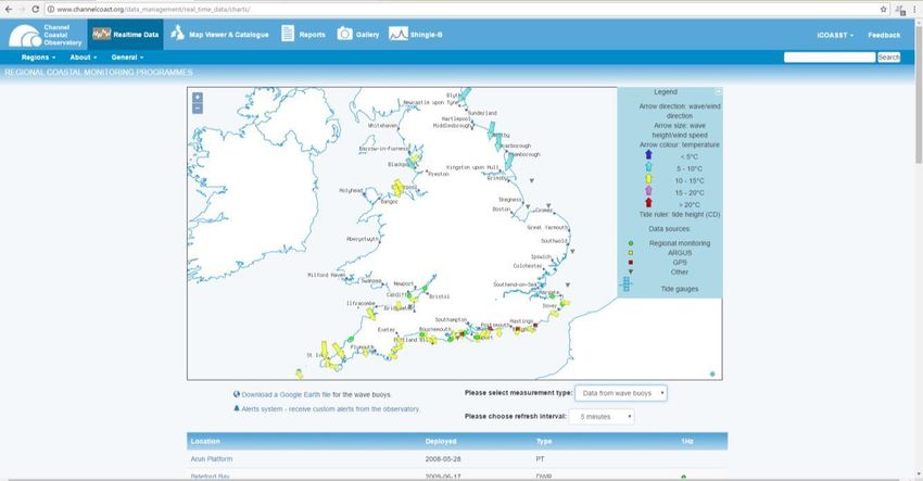
Summary of Key Findings:
Northern Ireland faces major and increasing risks from coastal erosion and marine
flooding
We lack the basic information needed to make sound decisions around these risks
Northern Ireland’s Coast is one of its most important assets, contributing to the
economy and quality of life of all its residents
The incidences of flooding and coastal erosion are increasing as a result of climate and
sea-level change
About 32% of the Northern Ireland ocean and sea-lough coast is currently armoured.
Armouring protects property but is environmentally damaging.
A strategic approach to shoreline management is urgently needed to address the
challenges of marine flooding and erosion: current shoreline management is reactive
and poorly structured and continuation of current practice will lead to coastal
degradation and loss of amenity value
There is an absence of adequate information on which to base coastal decision-making.
Northern Ireland has a lack of information on how its coast works (e.g. rates of change,
sources of coastal material, patterns of sand movement, impact of storms, post-storm
recovery) along most of the coastline.
Establishing a coastal observatory in Northern Ireland is essential to provide the
necessary support for decision-making in the current framework and in any future
strategic approach.
1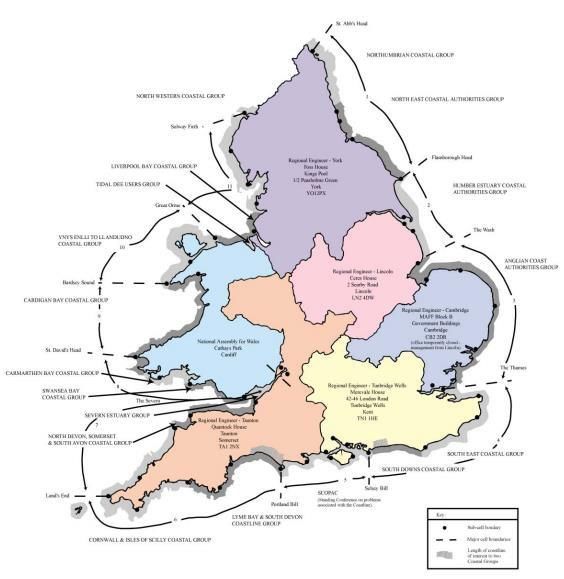
1. Introduction

1.1      The Northern Ireland coast

The Coast of Northern Ireland is one of its most valuable natural assets. It is among the most
variable coastlines in the world, with more geological diversity than any coast of equivalent length.
This creates a range of scenic landforms and natural environments. From the North Atlantic to the
Irish Sea there is an array of picturesque coastal features (dramatic cliffs, sandy beaches, sand
dunes) that create an internationally renowned scenic landscape that underpins the tourism
industry and provides recreational and leisure opportunities for residents. The coastal landscape
also provides diverse coastal habitats, and these sustain important commercial and recreational
activities. The Peace Process has seen large increases in visitors to Northern Ireland, many of them
attracted by its coastal landscape.

The Northern Ireland coast is also the locus of much industrial and commercial activity and
habitation. Ports and harbours of various sizes, roads and railway lines and housing are among the
infrastructure of its coastline. The accumulated record of human activities along the coast (the
archaeological record) is itself an asset that brings economic benefits and, like the natural coastal
attributes, contributes to the population’s wellbeing.

Infrastructure and human activities co-exist with the natural coast in Northern Ireland and each
impacts the other in various ways. All activities and habitats, however, rely on the physical nature of
the coast and are affected by any changes in coastal configuration. The most common illustration is
that erosion may undermine and threaten infrastructure. Conversely, human activities impact the
environment, for example, building seawalls to protect infrastructure may cause beaches to be lost.

Understanding how and why the coast changes is vital to establishing a sustainable relationship
between human activities and natural coastal processes. Ideally, for example, activities and
infrastructure would be placed so as to be least affected by, and exert the least effect on, natural
coastal processes. When this is not the case, conflicts arise.

An understanding of how the coast works, (e.g. how it responds to storms, how it changes over
decades, where its sediments come from and go to) is vital for effective shoreline management.
Knowing and understanding these linkages enables better design of infrastructure and better
planning for the benefit of all. Without it, decision-making is severely impaired and ultimately the
natural coastal assets that attract significant numbers to Northern Ireland will undergo increased
pressure and through ill-informed management, will be adversely impacted.

When storms cause coastal retreat in Northern Ireland, or when permission is sought to undertake
works in the coastal zone, there is currently little information on which to base decisions. For
example, rates of coastal change, effects of storms and the longevity of their impacts, the seasonal

                                                                                                        2
behaviour of the coast, interactions between beaches and dunes, the likely impact of coastal
structures etc., are not known. Without this information, shoreline management is operating in a
vacuum. In certain cases, existing and future infrastructure placed at the coast in Northern Ireland
may be endangered under the current scenario of poor scientific understanding from lack of regular
monitoring data being undertaken.
Cooper et al. (2016) estimated that 32% of the Northern Ireland coast (including its sea loughs) is
armoured while CCIP (2009) estimated 19.7% (excluding sea loughs). These figures compare to 44%
in England and Wales and 6% in Scotland (Cooper et al., 2016). McKibben (2016) estimates that
19.5% of the Northern Ireland coastline is suffering from erosion, compared to 29.8% in England. He
also noted that 46,000 properties are at risk from fluvial or marine flooding and that coastal flooding
may have a greater impact on public safety, economic activity and the environment. No comparable
figures are available for coastal erosion, but recent stormy winters have precipitated major impacts
on coastal residents and those using the coastal road and rail infrastructure.
The amount of armouring varies around the coast and also according to coastal type. Large areas of
slowly eroding hard rock cliffs lack armour while over 25% of sandy beaches are backed by sea
defences. Coastal defences in turn can have impacts on the environment (beach narrowing,
scouring creation of knock-on effects down-drift, loss of amenity). The natural buffering effect of
coastal systems is lost and the artificial sea defences incur costs of installation and ongoing
maintenance. In some cases, sea defences are essential to protect vital infrastructure, but in many
cases they are not and other options exist.
In this report, we describe the monitoring and baseline information needed for effective shoreline
management and assess the current availability of such information for Northern Ireland. We
conclude with recommendations on how to best fill the information gaps and monitor ongoing
coastal changes.
1.2 Climate Change and the Northern Ireland Coast
Climate change in Northern Ireland is leading to warmer temperatures and a higher sea level (UK
CCRA 2017 Risk Report). The net effect is an increase in the frequency of coastal flooding and rates
and extent of coastal erosion.
The UK Climate Change Risk Assessment (CCRA) 2017 identifies “flooding and coastal change risks to
communities, businesses and infrastructure” among its top 6 areas of climate change risks and
designates it as the highest risk magnitude both now and into the future . It identifies the following
as areas where more action is needed (i.e. “New, stronger or different government policies or
implementation activities– over and above those already planned – are needed to reduce long-term
vulnerability to climate change”):
Ne12: Risks to habitats & heritage in the coastal zone from sea level rise; loss of natural flood
protection
3In Northern Ireland, the CCRA Evidence Report notes, “More action needed to deliver managed
realignment of coastlines and create compensatory habitat. No system is in place in NI to decide
which areas must be protected and where realignment or retreat is more appropriate”
In3: Risks to infrastructure from coastal flooding & erosion
The CCRA 2017 identifies the following research priorities (i.e. “Research is needed to fill significant
evidence gaps or reduce the uncertainty in the current level of understanding in order to assess the
need for additional action”):
In12: Risks to onshore infrastructure from storms and high waves
PB6: Risks to viability of coastal communities from sea level rise
PB8: Risks to culturally valued structures and historic environment
Bu2: Risks to business from loss of coastal locations & infrastructure
At a time of rising sea level, it is inevitable that coasts will change. Northern Ireland is now entering
a phase of rising sea levels that will cause a re-shaping of the coastline as it adjusts to these changing
conditions. These changes will affect existing and new infrastructure and will result in more
frequent flooding and a general tendency for shorelines to move landwards that will be experienced
as erosion. CCRA 2017 identifies this as a research priority for Northern Ireland.
In N.I. there is no system in place to decide which areas must be protected and
where realignment or retreat is more appropriate. More research is needed to
understand whether current coastal policies are realistic in context of climate
change.
UK Climate Change Risk Assessment 2017: Evidence Report, Northern Ireland
The amount of infrastructure at risk from sea-level rise in Northern Ireland is predicted to increase
(CCRA 2017). The length of strategic road network and railway network at risk will increase by 28%
and 13%, respectively.
To live in this changing environment, it is imperative that we develop an understanding of how the
coast works and how it is likely to change into the future. Appropriate shoreline management
strategies will have to be developed and those can only be built on proper data and understanding
of the physical behaviour of the coast. At present, our understanding of the Northern Ireland coast
is limited to a few sites that are known in some detail from academic studies. Elsewhere, we have to
rely on expert judgement and inferences based on studies elsewhere. This very much impedes
effective decision-making at the coastline.
41.3 Shoreline Management Planning and Coastal Observatories
Shoreline Management Planning (SMPv2) in Great Britain is a formal strategic process of decision-
making regarding coastal change. It provides scenarios of coastal change that help local/regional
councils in conjunction with the Environment Agency and other coastal stakeholders in decision-
making. It provides a framework for coastal management, and in particular, decisions regarding
coastal defences or other approaches to shoreline change. Region-wide coastal monitoring is vital if
coastal management decisions are to be made based upon accurate and up-to-date information on
coastal change.
There is no specific legislation to manage coastal erosion risk in Northern Ireland,
such as the Coast Protection Act 1949. As consequence, no government department
has systems in place to manage the risk from coastal erosion. Recent winter storms
(2013-14) have resulted in requests for new sea defence structures around the coast.
There is no system in place to decide which areas must be protected and where
realignment is more appropriate. However, the Strategic Planning Policy Statement,
2015, states that no development should take place in areas known to be at risk
from coastal erosion
UK Climate Change Risk Assessment 2017: Evidence Report, Northern Ireland
SMP in England and Wales is underpinned by data on shoreline status, hydrodynamic forcing and
coastal change that is gathered and/or collated by a series of ‘Coastal Observatories’, each of which
is responsible for a stretch of coast of broadly equivalent dimensions to those of Northern Ireland.
While Northern Ireland does not have such a strategic approach to shoreline management, the types
of data collected by coastal observatories could greatly help in informing decision-making in the
existing policy and regulatory framework, and would be essential if a strategic approach were to be
adopted in the future.
The coastline of England and Wales is divided into 11 “coastal cells” or stretches within which coastal
processes, sediment transport and landforms can be considered collectively (Fig.1). Each cell is
associated with a ``regional coastal group`` that comprises the relevant local authorities, Natural
England, the National Trust and the Environment Agency. A Regional Coastal Monitoring
Programme is established for each area in consultation with stakeholders (each programme is
tailored to the specific needs of that area) and is administered by a coastal observatory.
5Figure 1. Coastal cells and coastal management groupings, England and Wales
“… regional coastal monitoring programmes routinely and systematically
provide essential data that enables the various maritime Local Authorities
and the Environment Agency to appraise, identify and deliver cost-effective,
technically feasible, and environmentally acceptable and relevant solutions
to a wide range of coastal erosion and sea flooding risk management
problems”.
http://www.northeastcoastalobservatory.org.uk/images/FCRM%20Conference%202009%20paper.PDF
Coastal observatories have been established for the coastline of England and parts of Wales. The
earliest was established in 2002 and the most recent in 2008. They are 100% grant aided by Defra
and each is managed by a local authority on behalf of the relevant Coastal Group.
`` The National Network of Regional Coastal Monitoring
Programmes consists of six Regional Monitoring Programmes. For
each programme a Lead Local Authority takes responsibility for
funding applications, budget control, data collection, quality control,
implementation of the programme and makes sure the programme
gets delivered to its partners in the Regional Programme and the
6Coastal Group. The Lead Authorities for the Regional Programmes
are:
Northeast - Scarborough Borough Council
East Riding - East Riding of Yorkshire Council
Anglian - Environment Agency
Southeast - New Forest District Council
Southwest - Teignbridge District Council
Northwest - Sefton Metropolitan Borough Council
The Programmes collect and distribute the necessary data to
underpin evidence-based decisions regarding strategic and local
level Flood and Coastal Erosion Risk Management (FCERM).
Funding for the Programmes is secured in five-year cycles from
DEFRA and administrated through the Environment Agency.``
http://www.channelcoast.org/introduction/
Observatory staff are local authority employees and are usually located in university premises to
facilitate strong links with research communities and provide opportunities for value-added research
programmes. A variety of modes of data collection are employed. In some cases surveys are
undertaken by observatory staff, while in others they are subcontracted.
The following data collected by Coastal Observatories in England and Wales serves as a yardstick
against which current data gathering in Northern Ireland is assessed in this report:
Beach profile measurements (Baseline and regular updating)
Lidar surveys (Baseline and change)
Aerial Photography
Historical mapping and updates
Bathymetric surveys (baseline and updates)
Hydrodynamic data (tide gauges, current meters, wave buoys
Ecological Monitoring using integrated habitat classification system from aerial photography
While all the observatories adhere to a similar format, the specific details of data collection are
customised to each region´s needs. For example, in the Northeast, where soft cliffs are common, a
number of cliff line monitoring stations have been established. In areas, where sea defences are
abundant, the survey programme includes visual appraisal of sea defence status by walk-over
surveys.
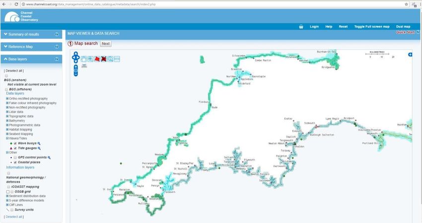
The information gathered by observatories is freely available online in a number of formats. Raw
data, annual summaries and interpretative reports can all be downloaded to aid decision-making.
7Figure 2. Screenshot showing data availability from SW Coastal Observatory region. Data can be
downloaded directly and real-time data are available from wave recorders and tide gauges (Fig. 3).
Figure 3. Screenshot showing real time wave data from Coastal Observatory wave buoys.
At the Shifting Shores+10 Seminar (Belfast, January 2016), the work of English Coastal Observatories
was described and the lack of an equivalent coherent programme of coastal data collection
(topographic and hydrodynamic) in Northern Ireland was highlighted. It was apparent that several
8organisations (e.g., government departments and agencies, local authorities, universities,
commercial enterprises) collected coastal data of various types in Northern Ireland but these were
of varying spatial extent, resolution and timing. Although these data are being collected for
particular needs, they may have more widespread utility in coastal management. It also appeared
that several types of data (particularly beach profiles and wave data) were not being collected. A
key issue for evolving shoreline management in Northern Ireland was knowing what data are
collected, format basis, and being able to access them for decision-making.
The aim of this report, commissioned by the National Trust (NI), is to assess the current state of
coastal data collection in Northern Ireland, both for the purposes of establishing a baseline and for
monitoring of change. The full brief is contained in Appendix 1.
2. Existing data
This review set out to assess the degree to which baseline data and data on temporal change
(monitoring) exists or is being routinely collected in Northern Ireland. It is not an exhaustive study of
every individual survey (of which there are many, for example, in student projects, consultancy
reports, university research reports, and investigations by government agencies). Rather it focuses
on major datasets of baseline importance, key long-term datasets, and ongoing monitoring
activities. Each is described below, is tabulated in Table 1 and the spatial extent of some datasets is
shown in Figure 4.
2.1 Airborne Lidar
Airborne lidar surveys collect detailed, high-resolution, 3-dimensional topographic data at cm-scale
resolution. Several particular systems exist, but they are broadly divided into those that operate
only on dry land, and those capable of surveying land and shallow marine areas. A collation of data
gathered to date on the Northern Ireland coast, shows that several areas have been collected for
particular purposes by various agencies, in particular DfI Rivers under their remit for flood risk
management of both fluvial and coastal flooding. Collectively, the records available do not
constitute a monitoring baseline, but they could contribute to the future development of a baseline.
2.2 Air Photos
Air photos are excellent sources of information on past coastal conditions, and are a routine means
for monitoring change of various features that act as proxies for the shoreline (HWM, dune
vegetation edge, cliff base/top, etc). All of Northern Ireland has been photographed at various
intervals since 1974 and routine updates are now collected every 3 years. Older photography by
various agencies does exist but is not fully catalogued. There are potential sources within the
universities of selected themes.
92.3 Hydrodynamics
Water level records provide information on trends in sea level, plus the frequency and magnitude of
surges (i.e. water level above or below tidal expectation). Water level records are maintained at
several stations by DfI Rivers (http://www.ntslf.org/data/uk-network-real-time), BODC and Belfast
Harbour for varying lengths of time. Northern Ireland is at present, quite well covered with water
level monitoring, but the long-term data sets from which trends can be derived, are limited to Belfast
(which has significant gaps) and adjacent gauges in the Irish Republic (Malin Head). There are also
formatting difficulties for comparison of these data sets. The 2 ‘Class A’ tide gauges in NI are at
Portrush & Bangor but their records commenced in 1993/5.
Wave and tidal current records are useful for design of structures, understanding coastal response
to storms and identifying sediment transport pathways. Records have been collected off Lough
Foyle by the Commissioners of Irish Lights for two years. To our knowledge this is the only
systematic collection of wave data in Northern Ireland. No systematic collection of tidal current
data is undertaken, but tidal current models exist for Lough Foyle, Carlingford and Strangford , and a
coarse grid model (mean horizontal resolution = 1.9 km) of tidal currents around Ireland is
maintained by the Irish Marine Institute (http://www.marine.ie/Home/site-area/data-
services/marine-forecasts/ocean-forecasts). Modelled surface currents are provided at hourly
intervals.
2.4 Meteorological Data
Meteorological data is useful for characterising coastal conditions, monitoring trends and
quantifying storm magnitude and occurrence. A network of met office stations include coastal
locations around Northern Ireland. These provide good baseline information and ongoing
monitoring of wind speed and direction in particular.
There are a number of UK and international initiatives at global and regional level to use historical
atmospheric data to hindcast former wind and wave conditions. These ´reanalysis‘ projects provide
a useful historical database of coastal wave climates and extreme events. Similarly climate
modelling now enables incorporates forecasts of wave and current conditions to be made, similar to
routine weather forecasting Information from these initiatives could be used to develop Northern
Ireland-specific information.
2.5 Beach profiles
Beach profiles provide information on beach behaviour at seasonal and long-term intervals, as well
as the response to storms and subsequent recovery. They involve topographical measurement of the
beach surface perpendicular to the coast and usually extend from the backing dune/cliff to the low
water mark. The beach does, however extend below low water and sand is exchanged between the
beach and nearshore bars. Consequently, it is usual to measure topographic change below low
water. Because of the extra expense, this is usually done less frequently.
10Intertidal beach profiles have been measured monthly on 6 beaches by Causeway Coast & Glens
Council for 4 years (and for 10 years before that by Ulster University). Elsewhere, a few beach
profiles have been measured on an ad hoc basis in the course of academic and professional
investigations. These are not catalogued and are of varying quality and reliability. Most of Northern
Ireland´s beaches have no such data.
A related measurement, that of cliff line recession rates is also useful on soft cliff coasts where
ongoing erosion occurs (In Northern Ireland, this would apply to Drumlin coasts of Strangford Lough
and the south Down coast. Although some such monitoring work has been done in the past, none is
currently ongoing to our knowledge.
2.6 Bathymetry
Bathymetric data are essential for establishing a baseline and monitoring of change in the coastal
and nearshore zone. They also provide information essential to understanding wave transformation
at the coast, with implications for longshore drift, storm impact etc. Standard navigational charts
provide coarse-level and usually dated information on seabed bathymetry. Modern approaches
using multibeam bathymetry provide a much more detailed view of the seabed, enabling bedforms
(e.g. sandwaves, dunes), and rock outcrops, for example to be identified. Two large-scale multibeam
bathymetric investigations (JIBS and INIS hydro) provide such baseline data from the N and SE
regions, respectively. Between these areas, scattered areas have been surveyed by various agencies.
There is no programme of systematic monitoring of bathymetric change.
2.7 Ecological Monitoring
To our knowledge, the extent of coastal habitats is not routinely monitored using vertical aerial
photography. Coastal habitats within Areas of Special Scientific Interest are, however, subject to
routine site integrity monitoring using helicopter surveys
11Table 1. Main data types available at the Northern Irish coast and their details
TYPE of DATA HOLDER AMOUNT, LOCATION, DATES SUB-TYPE ACCESSABILITY
NI Rivers Agency
LIDAR (airborne) catalogued online but site specific (see GIS map) Terrestrial OPEN ACCESS
(LPS housed?)
Terrestrial & Marine
(Red Bay 3m
Redbay and Strangford Lough (small section NW) (see
AFBI resolution; small areas OPEN ACCESS
map)
of NW Strangford
coast 2m
Magilligan and most of Foyle
INFOMAR/OSI Terrestrial & Marine OPEN ACCESS
(see map)
" " " Benone to Rathlin (see map) Terrestrial/Marine OPEN ACCESS
NIEA (HED) some coastal sites using airborne lidar, patchy (see map) Terrestrial SUBJECT TO RESTRICTION
FUGRO-BKS patchy coverage of coast and various years (see map) Terrestrial PURCHASE ONLY
new initiative being proposed for all NI to be surveyed by
DAERA Terrestrial PENDING
lidar
6 beach locations along north coast (Downhill,
Castlerock, Portrush West, Portrush East, Whiterocks,
Beach Profiles Ulster University Terrestrial SUBJECT TO RESTRICTION
Portballintrae), multiple repeat DGPS profiles at each
site. since 2003, last 6 years on a monthly basis
Sporadic locations using GPS or levelling instruments and
located at sites such as Magilligan, Portstewart, Giants
Various Terrestrial UPON REQUEST
Causeway, Murlough (Co. Down), Cloughy beach. All
either irregular or one-off surveys
all of NI, multiple years from 1974 to present. Complete
various scales, vertical
AIR PHOTOS OSNI coverage of coastline every 3 years since 2003. Sporadic SUBJECT TO RESTRICTION
images
coverage pre-2003
various scales, vertical
BKS/Fugro sporadic coverage (see map) PURCHASE ONLY
images
12various scales, vertical
Historical (regular) photos of Ballykinler, Magilligan,
MoD images. Images not UPON REQUEST
Redbay and possibly
georeferenced usually
Georeferenced,
NIEA Snapmap (2006) or Visivi now, entire NI Coastline UPON REQUEST
oblique images
Local councils Some from Ards Borough Council. Sporadic vertical UNKNOWN
operate 11 offshore sampling points but only water
quality info collected. Located at North coast, L.Foyle salinity, temperature,
HYDRODYNAMICS AFBI UPON REQUEST
N&S, Belfast L., Lagan Impoundment, Strangford L. fluorescence, turbidity
North, Strangford Narrows, Quoile, Carlingford N & S.
British
Oceanographic Bangor - 1994 to present tidal heights PURCHASE ONLY
Data Centre
" "
Portrush - 1995 to present tidal heights PURCHASE ONLY
"
Belfast Harbour
five different tide-gauge positions/machine types
(Harbour tidal heights PURCHASE ONLY
within Belfast Harbour over the period 1901–to date
Commissioners)
January 2007 - Present (DfI Rivers Gauge – Lisahally)
1996 - Present (Harbour Commissioners Gauge –
Londonderry Port Lisahally). Note that some long gaps in these data. Rivers
and Harbour Agency data
tidal heights PURCHASE ONLY
Commissioners/ were recorded at 15 minute time intervals, whereas the
Rivers Agency time interval for the Port Authority varies across the
records (5 minutes for the 1996-2000 period and 50
seconds since 2000).
Marine Institute Malin Head - 1958 to 2002 (at 55.366667, -7.3333??? lat
tidal heights UPON REQUEST
(Galway) long?) then from 12 June 2008 at 55.37168, -7.33432
Dundalk - 2008 Apr to 2013 Jan tidal heights UPON REQUEST
- 8 gauge locations around NI various years:
• 201601 Lough Foyle @ Lisahally
DfI Rivers tidal heights UPON REQUEST
(16 years)
• 205601 Lagan @ Belfast Lough
13(12 years)
• 205119 Connswater @ Connswater Alert (adjacent to
Bombardier)
(5 years)
• 205037 Newtownards Canal @ Portaferry Rd Alert
(Strangford Lough): (2 years)
• 206008 Newcastle Harbour
(4 years)
• 206601 Warrenpoint Harbour
(12 years)
• 206301 Newry River @ Victoria Lock: (19 years)
Commissioners of wave height, wave
Off mouth of Foyle, since 2015 UPON REQUEST
Irish Lights period
wave height, wave
UK Met Office Hindcast modelling of wave parameters on coarse model PURCHASE ONLY
period
The numerical wave model SWAN simulates surface
gravity waves. Uses NCEP GFS for wind forcing and
FNMOC Wave Watch 3 data for the wave boundaries. A wave modelling
Marine Institute,
daily 6 day forecast is generated for parameters such as forecasts UPON REQUEST
Galway
significant wave height, mean wave period and mean
wave direction. All Irish waters (Incl. NI) at a resolution of
0.025 degrees (approximately 1.5km)
wave modelling
QUB/Met Hourly wave height and period for past and future
forecasts PENDING/ACCESS UNKNOWN
Eireann/DHI predictions using ERA-Interim Reanalysis data
NONE RECORDED but tidal stream (model) atlas by
Proudman and also by Marine Institute - Surface currents nearshore currents UPON REQUEST
provided in 1-hourly frequency
Strangford Sea Lough modelling (Delft3D‐FLOW
morphodynamics
AFBI and QUB Hydrodynamic) conducted Feb 2014, one-off RESTRICTED/ON REQUEST
modelling
Mike 21
Larne Lough hydrodynamic modelling Modelling
morphodynamics
AFBI (Delft3D‐FLOW Hydrodynamic) conducted by AFBI, one- RESTRICTED/ON REQUEST
modelling
off
Carlingford Lough, Modelling (Delft3D‐FLOW morphodynamics
AFBI RESTRICTED/ON REQUEST
Hydrodynamic) conducted by AFBI, one-off modelling
146 UK Met office stations operate around NI coast
UK Met Office; (Magilligan, Giants Causeway, Helens Bay, Orlock Head, PURCHASE ONLY
MET DATA Wind
Ulster University Murlough, Killowen), 3 Ulster University met stations
(Magilligan Point, Portrush and Strangford Lough west)
BATHYMETRY INISH HYDRO Dundrum bay, Carlingford? Multibeam UNKNOWN
Harbour
Foyle, Larne, Belfast Multibeam ON REQUEST
Authorities
Joint Irish Bathymetric Survey (JIBS).
IHO order 1 standard bathymetry for the nearshore and
MCA and others beyond extending from Fair Head, around Rathlin Island Multibeam OPEN ACCESS
and extending to Inishtrahull Island off Donegal (See
Fig.1)
NIEA (now DAERA) Dredge spoil site monitoring Multibeam ON REQUEST
Hydrographic Admiralty Charts,
All of NI waters, various ages PURCHASE ONLY
Office various scales,
from the mouth of Belfast Lough to Glenarm Point, north
Royal Navy/UKHO Multibeam ON REQUEST
of the Maidens (2009)
at three locations during separate cruises covering North
Klondyke (repeating the area covered by the Marine
Multibeam
Institute in the MESH project), the area surrounding
(Red Bay 3m
Outer Klondyke (2009) and the East and West Maidens
AFBI resolution; small areas ON REQUEST
(2009).
of NW Strangford
Redbay and Strangford Lough (small section NW) (see
coast, 2m resolution
map)
Marine Institute
North Klondyke – MESH survey, 2003 Multibeam OPEN ACCESS
Galway
ECOLOGICAL Ecological monitoring is not currently conducted
NIEA Aerial photography N/A
MONITORING regularly through vertical aerial photography, but
routine site integrity of Coastal habitats within
ASSIs are monitored using helicopter surveys.
Vertical Aerial
NIEA CORINE land classification UNKNOWN
photography/mapping
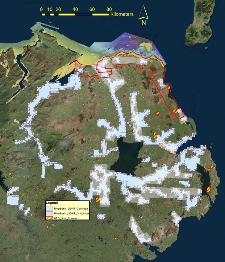
15Fig. 1 Coverage location map of the various sources of lidar and aerial surveys in Northern Ireland.
The offshore/nearshore multi-beam is also shown (not in key) for the north coast. Area inside red
line is Fugro BKS aerial survey in 2010.
163. Summary: Data and data gaps
In Northern Ireland, despite several independent data-gathering initiatives for various purposes, the
information necessary to inform good decision-making at the coast is currently lacking and/or is not
readily accessible. Equally importantly, the data that do exist have not been fully utilised to gain an
understanding of how the coast works (rates and patterns of change, causes of change, impacts of
particular events (storms, surges)). As the events of the past few winters (2013/14 and 2014/15)
have shown, this information is needed to underpin decision-making. Erosion caused by winter
storms is sometimes part of a cyclic process in which lost sediment is returned to the beach. In
other cases, it is part of a progressive process of shoreline retreat where sediment is lost from the
system. Knowing the pattern of sediment exchange, the likely impact of storms of given magnitude,
and the recurrence intervals for such events, are all necessary for science-led shoreline
management.
The key findings are that:
Regular beach profile data are almost uniformly lacking. The only exception is a 4-year
monthly record on 6 North Coast beaches. Most beaches elsewhere in NI lack baseline and
regular monitoring data.
Lidar surveys exist only for small sections of the Northern Ireland coast.
Aerial Photographic coverage exists from 1970s. Regular surveys are flown by LPS at 3 year
intervals. These are subject to crown copyright and are not freely accessible (In contrast
Defra who have made its lidar data publically available since 2015). No systematic
comparison of shoreline change is undertaken as part of these surveys.
Large scale (6 inch & 1:10,000) historic maps exist for Northern Ireland coast from the mid-
1830s. LPS update maps on a planned ongoing basis. These are Crown copyright with
attendant restrictions on use and reproduction. No systematic assessment of coastal change
is undertaken.
Northern Ireland has a good bathymetric baseline on the North Coast and Dundrum Bay-
Carlingford Lough, with smaller patches of multibeam bathymetric data between these
zones. A few zones have been surveyed more than once, but there is no programme of
monitoring change.
The long-running tide gauge at Belfast has data gaps. Several organisations (DfI Rivers,
Harbour Commissioners, PSMSL) maintain shorter-duration tide gauges and water-level
records in tidal waters. Their deployment ranges from 2 to 19 years. They have the
potential for detection of long-term change and surge records.
Wave measurements and tidal current measurements are currently lacking on the Northern
Ireland coast with the exception of a single buoy located off the mouth of Foyle estuary
(since 2015).
Ecological monitoring does not utilise air photography to quantify regular changes in habitat
extent.
Lack of proper coastal and marine data is likely endangering present and future
infrastructure placed at the Northern Ireland coast through poor understanding of coastal
behaviour and processes because of data paucity and irregular monitoring taking place.
17 Developments permitted at the coast where the dynamics of coastal processes are poorly
understood will lead to direct environmental impacts and likely loss of natural amenities
such as sandy beaches and dunes, thereby affecting future tourist potential.
It is clear that the information considered essential for shoreline management and that is currently
provided by coastal observatories in Great Britain is lacking in Northern Ireland. In particular, the
following are needed to inform shoreline management:
Identification of beach/cliff line monitoring stations around the coast and at least seasonal
topographic monitoring
Complete lidar coverage of the coast and a programme of repeat surveys at 5 year intervals
Deployment of wave buoys on the North and East Coasts
Deployment of tidal current recorders on North and East Coasts
Maintenance and collation of records from existing tidal and water level recorders
A programme of aerial photography of the coast with repeat surveys at 5 year intervals
Collation and analysis of existing and new data
Interpretation of how the coast works in an accessible format
Web-based delivery of coastal data and reports to decision-makers
4. A coastal Monitoring Observatory for Northern Ireland
A coastal observatory, similar to those in GB, but tailored to Northern Ireland´s specific needs, is
considered essential to facilitate effective shoreline management The role of such an observatory
would be to collate and make accessible existing data, co-ordinate data gathering to ensure
maximum effectiveness and utilisation, fill data gaps, provide interpretation of data for use in
decision-making. Here we consider options for establishment of such a facility.
4.1. ‘Architecture’
The role of a coastal observatory with respect to the data outlined above is threefold:
To collect available coastal data (and to initiate through partnership, new data
collections.
To collate, seek common collection formats and make accessible, coastal data from
observatory and other sources
To provide reports on coastal data to government departments, agencies and local
authorities
To deliver these functions, and following the experience of similar institutes in England, it is
envisaged that a coastal observatory for Northern Ireland would require a technical staff of five.
One manager (and data analyst) and four surveyor/data analysts. These staff would:
collect beach profile, wave, and tidal current data;
collate bathymetric, aerial photography and historic map data;
integrate these data into an online database;
18 commission additional data gathering (Lidar, Bathymetric surveys) to complete baseline and
monitor at 5 year intervals
Maintain and update the database with new monitoring data
Serve as a data repository for scattered/ad hoc historical data as it becomes available
Write annual reports on coastal data gathering and coastal change
4.2. Initial Set-up
The initial phase of the observatory’s existence would see several preparatory steps to underpin the
future work of the observatory. These include:
Formalised lines of responsibility and accountability within NI government, local authorities and
external agencies.
Establishment of beach profile base stations. Approximately 200 beach profiles would be
established around the Northern Ireland coast extending to just at or around low tide levels.
Following experience from English coastal Observatories, these will be located to be both
‘representative’ of the given beach and accessible to surveyors. Spacing would vary from site to site
and would vary from 10 to 300 m spacing. In the initial phase, fixed markers would be
located/installed and levelled on each profile. Routine surveying of these profiles would cover the
intertidal and supratidal zone, with less frequent offshore extensions to water depths of -20 m (limit
of appreciable change).
Wave and tidal current recorders. Installation of wave/current recorders would be an early
requirement of the observatory’s work. At a minimum these would include recorders on the north
Coast, NE coast and SE Coast. These could potentially use existing moorings.
Database design. A suitable database in which to store, manage and distribute coastal data would
be established. It is envisaged that this could utilise an existing framework as used in English
Observatories.
The costs associated with this phase include initial hardware and software, wave recorder purchase
and deployment, acquisition of GPS and terrestrial survey equipment.
4.3 Costings*
Initial set-up Capital Items:
2xTerrestrial Lidar £100,000
2x DGPS with 2 receivers £100,000
Computing hardware and software £ 30,000
3x Wave/current meter (ADCP) £180,000
19Deployment wave/current meters £ 40,000
Miscellaneous £ 30,000
Total: £480,000 + VAT
Annual Costings*:
1. Staff (salary and costs of 1 manager and four technicians) £250,000
2. Running costs (indicative)
2.1. Travel and subsistence (200 profiles surveyed 2x per year) £100,000
2.2. Equipment maintenance contracts £ 50,000
2.3. Software licences £ 30,000
2.4. External contracts (Airborne Lidar/multi-beam bathymetry) £200,000
2.5. Stationery office supplies £ 5,000
2.6. Equipment depreciation (5 years) £100,000
Total £735,000 + VAT
*note that additional costs may added depending on the final hosting structure of the
observatory
5. Utility of coastal data in current/future regulatory framework
Making informed decisions about the coast requires an understanding of how the coast
works. This in turn needs to be based on sound observations such as those outlined above.
This information is fundamental to understanding how the coast works and how it is likely to
change in the future. It enables risks to be assessed and for proper consideration of options
when considering all development in the coastal zone. With unprecedented pressure on the
coast for development of various types, at a time of sea level rise, this kind of information is
absolutely essential. Without it, planning and decision-making is based on guesswork
and/or uninformed judgement and has a high degree of uncertainty. Without informed
management, the values associated with the Northern Ireland coast could be lost through ill-
conceived developments and interventions.
5.1 Coastal Geomorphology and Temporal Change
Beach profile data, lidar data, bathymetric data and aerial photographic surveys provide
information on the seasonal and long-term behaviour of the coast including its response to
storms. They provide information on how beaches work (how sand moves, where it comes
from and goes to, and at what timescales) and the likely impact of various developments
(e.g sea defences, groynes, and jetties). This information is invaluable in design of
structures, assessment of risk, response to storm events, planning decisions and
environmental impact assessment. In the current policy and regulatory framework they
have implications for planning decisions, planning policy, environmental monitoring of
20designated sites, marine licensing, and operational issues relating to access and safety, for
example. At the moment, the key players are the super council planning groups and DAERA
Marine Division who between them exercise licensing/ planning permission.
The Regional Planning Policy for the coast recognises the particular attributes of the natural
and developed coast. It states for example, that development will not normally be
permitted in areas known to be at serious risk of flooding or coastal erosion and expresses
the aim to protect existing wildlife habitat and seek opportunities for new habitat creation.
The information needed to make these categorizations is, however, rarely available because
of the lack of data.
5.2 Hydrodynamic data
Wave and current data are useful to understand the physical changes described above.
They provide information on average and extreme conditions and their relationship to
coastal morphology. In addition, these data are useful in search and rescue operations,
design of offshore installations (e.g. marine renewable energy devices, pipelines, and
cables), conservation management, pollution monitoring, waste disposal, extraction, and
navigation.
Water level data provides a temporal record of variation that enables identification of long-
term trends (sea-level change), and the nature and frequency of extreme events (surges).
Both provide an underpinning for flood risk assessment, and climate change adaptation
5.3 Future Utility
Over the past two years there has been discussion of the coastal erosion issue in the
Northern Ireland Assembly. Various ministers of several departments have made positive
statements regarding the need for a strategic approach to coastal erosion risk. Nonetheless,
it does not appear explicitly in the current draft programme for government. However, the
aspiration to live and work sustainably, protecting the environment would be well served by
adoption of a strategic approach to shoreline management.
In the event of future legislation to enable a strategic approach to shoreline management in
Northern Ireland, such information would from a vital input to decision-making regarding
coastal defence designation and subsequent shoreline management. This is currently the
case in England and Wales. The data would inform climate change adaptation plans.
6 Recommendations (including funding)
It is recommended that a coastal observatory be established in Northern Ireland for the purposes
outlined above. Several potential options exist for the hosting of the observatory. These are briefly
outlined below:
Option 1. Establishment within a relevant agency or department.
21The unit could be established within an existing agency (for example, AFBI, Land and Property
Services or DfI Rivers) or department (DAERA (Marine & Fisheries Division) & Dept. of Infrastructure
(DOI)) that has related expertise and a remit related to coastal management. These bodies currently
have technical expertise that is complementary to the work proposed for the observatory. In the
event of strategic shoreline management planning being implemented, the choice of agency might
be steered by the lead agency for SMP.
The advantages of establishment within government include an enhanced ability to communicate
between departments and to draw on existing expertise and information, using inter-departmental
agreements. It would also facilitate the exchange of information between the observatory and end-
users in government. The resources of government in data gathering, data management and
distribution could be utilised and the embedding within government structures may provide for
longer-term stability. The potential downsides include the fact that the observatory would
necessarily be operating with a remit that goes beyond a single department, and this can be
problematic.
Option 2. Establishment within an external organisation.
The unit could be located within an organisation such as a University that has established coastal
research capacity and interests. This is the common model in England and Wales and provides for
synergy between coastal researchers in the academic world and those in the observatory collecting
the coastal data. Currently, coastal observatories in GB are 100% grant-aided by Defra and a 5-year
programme has been agreed. The advantages of independence for an observatory include the
ability to work across departmental boundaries, greater flexibility and synergy with the research
community. Disadvantages relate to the continuity of funding and the uncertainties that arise at the
end of each funding cycle.
Funding
The benefits that would accrue from a Northern Ireland Coastal Observatory are important to all of
its population and are the joint responsibility of government. The amount of money required for its
operation is relatively small and such an important body of work should be fully funded by
government, whether through a single department or a multi-department funding model.
The data collation, transfer and collection is of inter-departmental utility, and draws up on various
inputs. In the event of a lead department for any future strategic approach to shoreline
management in Northern Ireland, that department would be the ideal host and funder of a coastal
observatory. If an observatory were to be established outside government, it might more readily be
co-funded by more than one department. The work of the observatory, being relevant to several
government departments and to several local authorities with a coastline, is of high importance to
all of Northern Ireland and if shared between departments.
As in the case of JIBS and INIS hydro, external funding could potentially be sought for one-off large
scale baseline studies. Both those initiatives, however, were Interreg-funded and the situation
regarding access to such funding or alternative sources post-Brexit is still not clear. Monitoring
activities that are not currently undertaken would be the responsibility of the observatory. It is
possible that the data gathered would form the basis of academic studies by universities and this
22might generate applications for research funding to support these interpretations. Plymouth
University, for example was successful in generating UK Research council funding to exploit
observatory data on coastal response to storms. In Great Britain, repeat lidar surveys are
undertaken and funded by the environment agency. In Northern Ireland, the coastal observatory
could facilitate cost-savings by co-ordinating and rationalising coastal topographic survey work being
undertaken by various agencies.
7 References
Committee on Climate Change, 2017a. UK Climate Change Risk Assessment 2017. Synthesis report:
priorities for the next five years.
Committee on Climate Change, 2017b. UK Climate Change Risk Assessment 2017. Evidence Report.
Summary for Northern Ireland.
Cooper, J.A.G., O’Connor, M.C. and McIvor, S. 2016. Coastal defences versus coastal ecosystems: a
regional appraisal. Marine Policy. doi:10.1016/j.marpol.2016.02.021
McKibbin Des, 2016. Legislative and policy response to the risk of coastal erosion and flooding in the
UK and Ireland. Northern Ireland Assembly, Research and Information Service, Research Paper NIAR
274-16.
23Appendix: Brief
Northern Ireland Coastal Data Research Project
Project Title – An audit of the existing coastal data in Northern Ireland, its accessibility, quality and
deficiencies
Project Background
At the Shifting Shores + 10 Seminar held in January 2016 the lack of coastal data in NI was
highlighted. It was acknowledged that there were some existing data but in a fragmentary form, not
always accessible or quality assured to an agreed standard. The aim, off the back of this data audit
project, would be to pave the way for coastal monitoring in NI along similar principles and standards
to those undertaken at coastal observatories in England, Wales and Scotland. This in turn would
provide an evidence base from which to undertake a National Coastal Change Assessment for
Norther Ireland, itself a precursor to establishing a system of Shoreline Planning in the public
domain.
Project Aims – To establish what coastal data exists, where it is held, the quality standard and
accessibility of existing data. From this audit to then identify the knowledge gaps and make
recommendation as to how to address them.
Research required
1. In order to assess the standardisation of the existing coastal data - gathering and monitoring
efforts, it should be assessed against the broad areas of data capture monitoring employed by
coastal monitoring observatories in England and Wales as follows:
Topographic surveys (monthly beach profiles at ca. 200 locations in an area equivalent to NI)
Lidar Surveys (annual to establish baseline and monitor change)
Aerial photography – including assembling an archive of historic aerial photographic data,
and going forward commissioning annual vertical surveys to be used in, shoreline position
assessment, infrastructure and development management and habitat monitoring e
24 Historic map data – assemble an archive of historic map data to establish past change ,
giving the ability to extrapolate to future coastal change
Bathymetric surveys (entire coast initially to establish baseline + annual surveys of key
locations)
Hydrodynamic data (directional wave buoys, tide gauges)
Ecological monitoring (based on aerial photography using integrated habitat classification
system)
2. According to the above headings, collate and catalogue what existing data is available including
relevant data from RoI (Louth and Donegal in particular) and data held at a broader geographic scale
through for example the Eurosion project.
3. Identify the key knowledge gaps for erosion data with reference to Point 1 above.
4. Demonstrate the relationship between existing flood data and prospective erosion data and show
how these data, in combination, might yield added value, where for example erosion risk might
exacerbate coastal flood risk
5. Make recommendations as to how to best to fill the information gaps, and propose indicative
costings
6. Outline what the ‘architecture’ of a coastal monitoring observatory for Northern Ireland might
look like and provide indicative costings (capital and operating) to establish an observatory
7. Make recommendations as to what effect better data and monitoring would have in the current
policy framework and limited regulatory framework, with particular reference to inform statutory
advice across government and its agencies and within local government
8. Identify what opportunities exist to source funding (including academic sources) to support the
development of a coastal observatory and any barriers that might need to be overcome.
25You can also read