Northumberland Line Public consultation booklet - Autumn 2020 - Northumberland County Council
←
→
Page content transcription
If your browser does not render page correctly, please read the page content below
Northumberland Line
  Public consultation booklet

IMAGES TO BE ADDED

                     Autumn 2020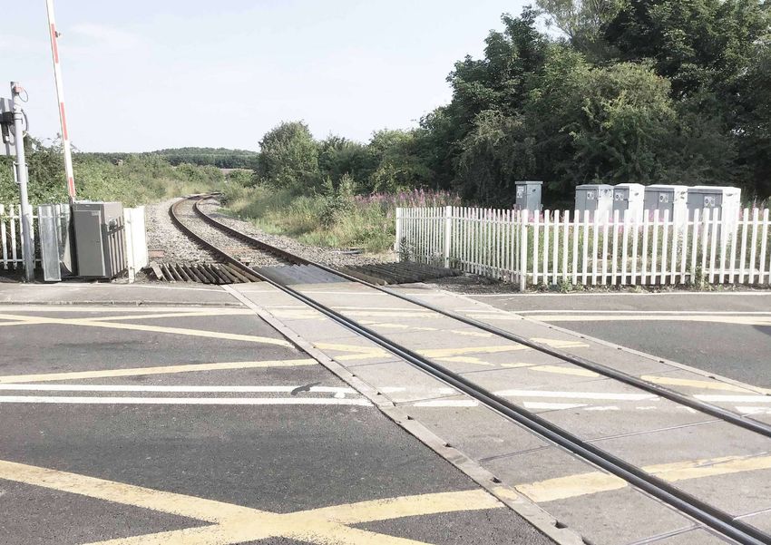
Foreword                                                                                      Contents
                                                                                              Introduction 							05
                                                                                                    What is the Northumberland line?			                     06
                                                                                                    The story so far 						07
                                                                                                    What are we consulting on and why?			                   08
                                                                                                    How do I find out what is happening in my area?         08
                                                                                                    What permissions and authorisations do we need?         09
                                                                                              Scheme overview 						10
                                                                                                    The route         						                                12
                                                                                                    The stations       						                               13
I’m delighted that the re-introduction of direct passenger trains between south-east
                                                                                                    Ashington to North Seaton Viaduct			                    14
Northumberland and the centre of Newcastle in the next three years is nearer than
ever. It’s been a long-held ambition of this council to get trains running again on the             North Seaton Viaduct to Bedlington Viaduct              26
Northumberland Line and over recent years we’ve made a great deal of progress. There’s              Bedlington Viaduct to Blyth Bebside       		36
ever more confidence our long-term aspirations are going to become reality – bringing               Chase Meadows, Newsham and New Hartley Curve 46
social and economic benefits to residents, commuters, visitors and businesses both in
                                                                                                    New Hartley Curve to Holywell		           		60
Northumberland and the wider region.
                                                                                                    Holywell to Benton North Junction			                    70
With a proposed opening date for passenger services in winter 2023, thousands of
                                                                                              More information about our proposals            		80
residents a day could be transported between Ashington and Newcastle in just over half
an hour, while the scheme could boost the local economy by up to £470m. Key to this                 Travel to and from the stations 				                    82
ambitious scheme is involvement from stakeholders, including residents and businesses,              Engineering works 						83
both along the route of the line and further afield.                                                Environmental management 				83
This booklet shows how our proposals have developed since they were last shared with                Landscape                                               84
the public in late 2019. We really want you to be part of this journey and would appreciate         Managing construction 					84
your feedback - either on specific elements or the scheme as a whole. I hope you can spare
                                                                                              How to have your say and next steps			                        86
a little time to read about the plans and give us your feedback on this major project.
                                                                                                    How to have your say 					                              88
                                                                                                    What happens next 					89

Glen Sanderson                                                                                  If you need this information in large print, braille, audio or in another format or
                                                                                                language please contact us:

                                                                                                Email:       rail@northumberland.gov.uk
                                                                                                Telephone: 0345 600 6400
                                                                                                Typetalk:    018001 0345 600 6400
Leader of Northumberland County Council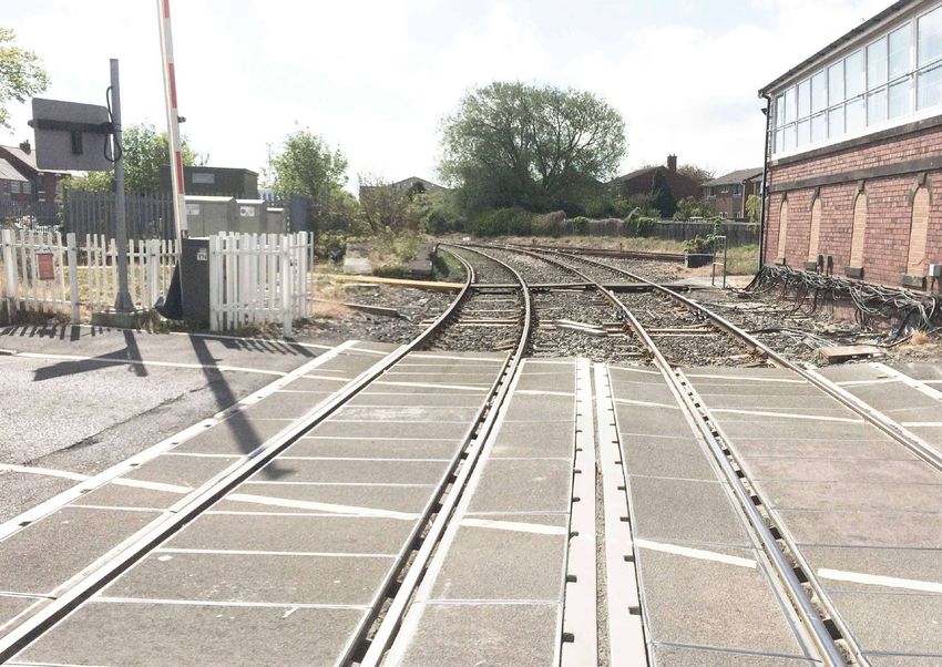
Introduction
What is the Northumberland                                                                    The story so far
Line?
The Northumberland Line will bring             The project will provide six new               The railway between Ashington and
passenger trains back into service             stations at Ashington, Blyth Bebside,          Newcastle used to run both passenger
between Ashington and Newcastle. It is a       Bedlington, Newsham, Seaton Delaval            and freight services until the Beeching
priority of both Northumberland County         and Northumberland Park, with journeys         cuts in the 1960s. Since then, freight trains
Council and North Tyneside Council and         between Newcastle and Ashington taking         have continued to use the line, primarily
is supported by a number of key project        about 35 minutes with no need to change        serving Lynemouth Power Station. The lack
partners, including the Department for         trains. The station at Northumberland          of passenger railway services in the area
Transport (DfT), Network Rail, Transport       Park will be adjacent to the existing Tyne     has contributed to local congestion due
for the North (TfN), Nexus and Northern        and Wear Metro station, bringing further       to car and bus travel being the only viable
Rail.                                          opportunities for interchange and travel       forms of transport for many. Congestion
                                               to other destinations. We are exploring        and long journey times have contributed
The Northumberland Line aims to                options for integrated ticketing between       to the economic decline of the area, with
stimulate and support economic growth,         the two services.                              people moving to live and work in other
regeneration and community development                                                        regions.
in Northumberland and the surrounding          At Newcastle station, it is anticipated that
regions by providing new and improved          Northumberland Line trains will run into       The reintroduction of passenger services
transport links for local people and           platform one, with easy access to the city     on the line has been an aspiration of
businesses. By doing so, the scheme will:      centre, Tyne and Wear Metro and national       Northumberland County Council for many
                                               rail connections.                              years and the current political, social,
• improve access from towns such as                                                           economic and rail industry context means
  Ashington and Blyth to employment            The freight trains that currently use the      that it can now be successfully delivered.
  hubs like Newcastle, as well as opening      railway will still be able to do so, helping   As a result of being awarded development
  up new opportunities for education and       support the economic aspirations of both       funding from the DfT, the council has been
  travel;                                      Lynemouth Power Station and the Port of        working alongside partners since 2018 to
                                               Blyth.                                         develop the scheme.
• provide a real incentive for potential
  employers to relocate to and invest in       A decision on who will run the trains on       Northumberland County Council
  the area;                                    the Northumberland Line is expected by         last consulted on proposals for the
                                               the end of 2020. The train service is likely   Northumberland Line in September and
• provide vital infrastructure to help         to be operated by trains made up of two,       October 2019. That consultation focused
  deliver the region’s aspirations for         three or four coaches.                         on raising awareness of the scheme and
  population and economic growth;                                                             finding out more about what local people
                                               The line is currently anticipated to open to   wanted from the service. Back then, we
• help to attract visitors and improve local   passengers in winter 2023.                     were also proposing delivering the project
  tourism;
                                                                                              in two phases, with some stations opening
• enhance public transport connectivity                                                       before others. We are now proposing a
  within and beyond the region;                                                               single-phase delivery, which will see all
                                                                                              stations on the route open at the same
• help to reduce congestion and improve                                                       time.
  air quality on key corridors by moving
  people away from car travel and onto           Anticipated service on the Northumberland      Headline results from the 2019 consultation
  public transport; and                                              Line

• support the delivery of significant                                                          Over 900           96 %             89%
  growth in sectors such as renewable
  energy, offshore oil and gas and                                                             respondents      supported      would use
  engineering.                                                                                                 the scheme      the service

                                                                                                       1/3                     &
                                                                                                  would use the        Appealing for
                                                                                                service more than      both leisure &
                                                                                                  3 times/week         employment

6                                                                                                                                             7
What are we consulting on How do I find out what is What permissions and
and why? happening in my area? authorisations do we need?
This booklet explains the various elements This booklet provides details of our The table below sets out the permissions The scheme also includes some works
of the Northumberland Line scheme, proposals to enable you to provide and authorisations that are needed to that, because of their nature and
including the six new stations, new feedback and comments. construct and operate different parts of location, do not require any permissions
footbridges and a potential underpass, the scheme. It also includes information or authorisations. This includes changes
changes to level crossings and the land For the purposes of this consultation, the about how the comments received to the existing track, laying of new
required to build it. It shows how our line has been divided into six geographical through this consultation will inform its track, upgrading signals and replacing
proposals have developed since they were sections, moving north to south. Page future development. equipment within the railway corridor.
last shared in late 2019. references for proposals in each section
are given below and on the map overleaf.
We are asking for your feedback on a
number of key scheme elements, which Ashington to North Seaton Viaduct,
will be signposted throughout this including Ashington station: Permission/ Needed for How your feedback will
booklet. Ways to respond are explained pages 14-25. authorisation needed inform this?
on page 88 of this booklet. You can Planning permissions Applications for planning permissions Your feedback on these
comment on those elements most relevant North Seaton Viaduct to Bedlington
Viaduct, including Bedlington station: will be made to Northumberland proposals will shape the
to you, or on the scheme as a whole. County Council and North Tyneside design and be summarised
We will use your feedback to inform the pages 26-35.
Council for some of the construction in a Statement of
further development of the scheme. and engineering works, including the Community Engagement,
Bedlington Viaduct to Blyth Bebside,
including Bebside station: new stations. which will form part of the
pages 36-45. As the scheme develops, further planning applications.
permissions (e.g. for construction
Chase Meadows, Newsham and New access roads) may need further
Hartley Curve, including Newsham planning permissions.
How to have your say
station: pages 46-59.
Transport and Works An application will be made to the Where private land
New Hartley Curve to Holywell, Act Order Secretary of State for an order under or rights are needed
You can respond to this
including Seaton Delaval station: the Transport and Works Act 1992. for the scheme,
consultation using our response
pages 60-69. The order (if made) would authorise: either permanently or
form, which is available online at
temporarily, negotiations
www.nland.uk/line, with hard
Holywell to Benton North Junction, • compulsory acquisition of land and and consultation will
copies available on request. rights (should it not be possible for
including Northumberland Park station: take place with those
these to be acquired voluntarily);
Full details of how to provide pages 70-79. directly affected by those
comments are given on page 88 • temporary use of land for requirements. Where
construction works; these proposals have a
of this booklet. The consultation will close on 14
• closure of level and other crossings wider impact (e.g. closure
December 2020 at 11.59pm. over the railway line; and of level crossings), they are
included in this booklet
• diversion and closure of public rights
so everyone has an
of way.
opportunity to comment.
Level crossing orders Applications for orders made under Many of the proposed
the Level Crossings Act 1983 will changes to level crossings
be made to the Office of Road and are required to ensure
Rail. The orders will specify the new they can be used safely,
operating arrangements at level but any feedback given
crossings. on level crossings will be
considered as part of the
design process.
Figure 1: Permissions and authorisations needed to build the scheme
8 9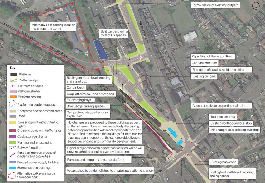
Scheme overview
The route The stations
Key
The route of the Northumberland Line is A-roads One of the project’s priorities is to They will also be fully accessible to people
shown below, along with page references enable people to travel quickly between with reduced mobility and other access
to where you can find more information Local authority boundary Ashington and Newcastle, helping requirements.
about our proposals in this booklet. The Tyne & Wear Metro encourage them to switch from car to rail.
following page outlines what you can With this in mind, the number of stations The stops will have ticket machines, but
expect from each of the stations, with Tyne Valley Line and their locations have been chosen to will be unstaffed and will not have ticket
further information about the specific carefully balance passenger demand and offices. Shelters will be provided on each
East Cost Main Line platform, providing waiting passengers
facilities and connections at each station journey times. However, the project does
site. Northumberland Line route not prevent the future development of with protection from the weather. These
and stations additional stations at other locations and shelters will have 8 to 16 seats, with extra
extensions to the line. standing space and access via each end.
Interchange with Tyne & Wear
Metro
All the stops on the Northumberland Line Toilets will not be provided at stations, but
will have facilities to help ensure safe and an accessible toilet will be available on all
easy journeys. trains serving the new line, which will run
roughly every half hour.
Ashington to North Seaton
Facilities at all stations The stations will not have dedicated space
for cafés or other retail facilities, but their
p. 14-25
Viaduct
designs allow for the possibility of pop-
up businesses, such as coffee carts, in the
North Seaton Viaduct to future. We are keen to find opportunities
p. 26-35
Bedlington Viaduct to support local businesses and involve
local people in the development and care
Bedlington Viaduct to of the stations to help ensure that they
p. 36-45
Blyth Bebside Ticket machines Seating and shelters reflect the needs of the community.
Chase Meadows, Newsham Noise levels from the stations, including
p. 46-59
and New Hartley Curve service and safety announcements,
will be controlled to minimise potential
disturbance to nearby residents and
New Hartley Curve businesses.
p. 60-69
to Holywell
Audio frequency Car parking
induction loops
Holywell to Benton
North Junction
p. 70-79
CCTV cameras Bike parking
0 1 3 5km Real time information Lighting
boards
Figure 2: Overview map Figure 3: An example of what real time information boards
could look like
12 13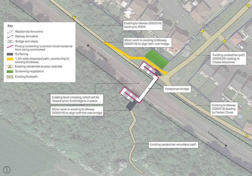
Ashington to North
    Seaton Viaduct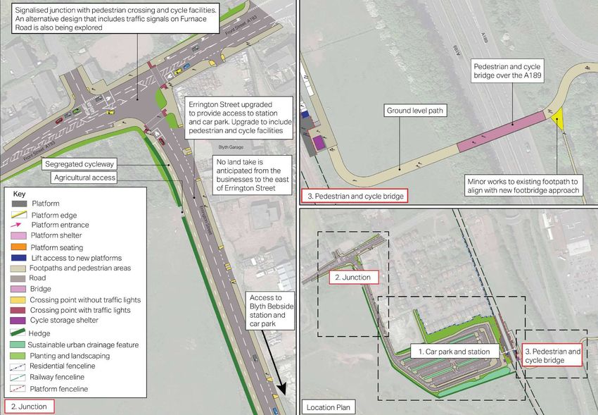
Ashington to North Seaton Ashington station
Viaduct
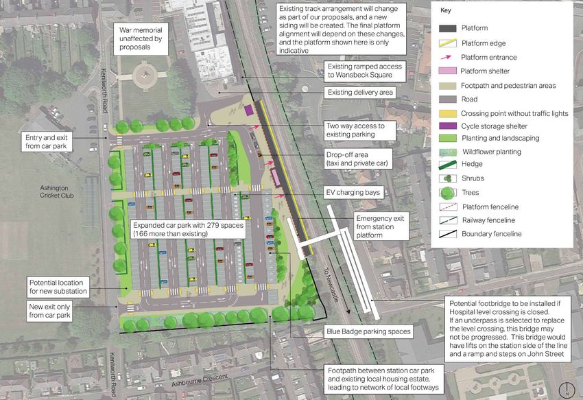
Ashington station will be the northern Effects of the proposals
end of the Northumberland Line. The
Between Ashington and North Seaton The key changes and some local track layout at the station has been The new station at Ashington will be well
Viaduct, there will be: landmarks are shown in the map below carefully designed so that the route can connected to Ashington centre and will
and are explained in more detail over be extended further north in the future, allow people living in Ashington to easily
• a new train station at Ashington; the following pages. In addition to these to locations such as Newbiggin and travel into neighbouring towns, Newcastle
• changes at three level crossings; and changes, engineering works will take place Woodhorn, though any such extension and further afield using public transport.
along the railway. would be part of a separate scheme. The journey time from Ashington to central
• sites that may need to be temporarily Newcastle will be around 35 minutes,
used for construction of the station The station will have a single platform on which will be significantly faster than the
and other engineering works. the west side of the line, located on part peak hour journey time by car and bus.
of the existing car park, as well as all the
facilities described on page 13 of this Our proposals also complement wider
booklet. regeneration plans for Ashington town
centre, which include a multi-screen
The existing car park will be extended, and cinema and restaurant complex at Portland
will include Blue Badge spaces and Electric Park and new homes. Northumberland
Vehicle (EV) charging bays. The number County Council is separately exploring
01
of car parking spaces available when the proposals for improvements to Wansbeck
station is complete will be more than those Square, adjacent to the new station. This
Key available in the current Kenilworth Road has potential implications for the design of
car park. Pedestrian and vehicle access the station and, as a result, the proposals
02 Key features into the car park will be from Kenilworth set out here might change to maximise any
Road and will be designed to maintain opportunities presented by that scheme.
Northumberland Line route
delivery access to Wansbeck Square
shopping centre and access to the rear of Some existing trees and green space
Green space will have to be removed to construct
Station Road properties.
the station and car park. This will be
Roads
The station and car park will include tree compensated for by new planting provided
03 New single platform station and car
planting and wildlife friendly landscaping, in alternative locations.
focused on the areas around the extended
parking. Potential for a new footbridge over As land in private ownership will be
01 car park.
the railway line. For more information, see needed to build the station car park,
page 22 It is likely that Hospital level crossing negotiations with landowners are ongoing
Potential closure of Hospital level crossing. will need to be replaced as part of the and may inform further development of
If closed, the crossing will either be Northumberland Line scheme. This is the design. We will seek to reduce the
02 replaced with an underpass here or a because of the increased number of trains extent of additional land required as far as
footbridge at the new Ashington station. using the line and the fact that the current possible.
For more information, see page 22 crossing is heavily used by schoolchildren.
We are currently considering options for An indicative plan showing our
Green Lane level crossing upgraded to a its replacement, including a footbridge proposals for Ashington station and car
03 full barrier crossing. For more information at the station and an underpass close to park is shown on the following page.
see page 23 the site of the existing crossing, which are
described in more detail on the following
Equipment and boundary fencing at pages.
North Seaton level crossing replaced and
upgraded. This work may involve some
04 04 weekend closures of the level crossing
and the road while the new equipment is
commissioned
North Seaton Railway Viaduct (no works
0 50 150 300m
05
05 proposed)
Figure 4: Works proposed between Ashington and North
Seaton Viaduct
16 17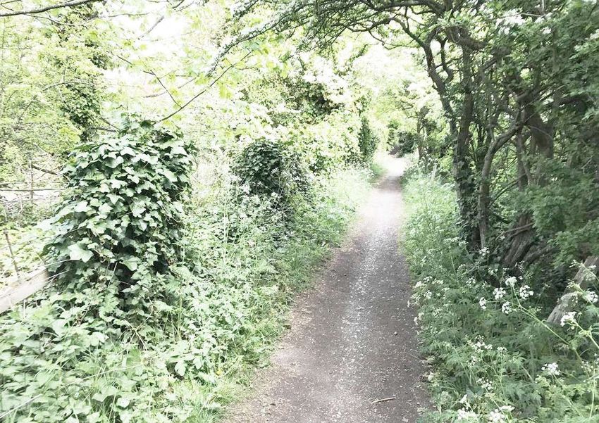
Figure 5: Proposed layout for Ashington station

18                                                19
Figure 6: Freight train going through Ashington

Construction

Our construction strategy is still being
formulated, and dates and durations for
the construction of Ashington station are
still to be confirmed. Information about
how construction will be managed to
minimise disturbance to local residents           We want to hear your views
and businesses is included on page 83 of
this booklet.                                     We are seeking your views on our
Our current plans include construction            proposals for Ashington station,
traffic accessing the station site from the       including any ways in which you feel
north using Station Road and Kenilworth           they could be improved. You can
Road, which will require some temporary           share your comments by answering
changes to the one-way system,                    the dedicated question on our
temporary diversions and other changes to         response form.
the local highways and footways. There will       Your feedback will be used to
be significant disruption to the availability     review the current proposals and
of parking spaces during construction             inform the detailed designs. You
of the station, with current users of the         will have a further opportunity
car park required to use alternative car          to comment on the planning
parking, which is available in Ashington          application for Ashington station
town centre. More information about               when it is submitted to the Local
alternative parking will be shared prior to       Planning Authority.
construction beginning.

20                                                                                       21
Hospital level crossing                                                                      Green Lane level crossing
Hospital level crossing provides access        Underpass                                     Green Lane level crossing enables
for pedestrians over the line between                                                        pedestrians and vehicles to cross the                                     We want to hear your views
Chillingham Crescent and Roseneath             A new underpass would be located close        railway line. The crossing will be upgraded
Court. Currently users ‘look out’ for an       to the site of the existing level crossing.   as part of the Northumberland Line                                        If you have any comments about the
approaching train and judge whether is it      Surveys and assessments are being             project, with changes to the barriers,                                    changes proposed at Green Lane
safe to cross, and the crossing is well used   undertaken to inform the detailed design      equipment and fencing.                                                    level crossing, please respond to the
by school children. As the Northumberland      of this potential underpass. Another key                                                                                relevant question on our response
Line project will mean more trains and         consideration for the detailed design will    In particular, the crossing will be upgraded                              form and reference ‘Green Lane
faster speeds, the crossing will need to       be how to help ensure it is a safe and        to have full barriers across the road                                     level crossing’ in your answer.
be upgraded or closed as a result of the       pleasant route for all users.                 and paths. These barriers will work
                                                                                             automatically and will be able to detect                                  We will use your feedback will be
scheme.
                                               The land needed to construct the              anyone trespassing into the crossing area                                 used to review the current proposals
Surveys and assessments are ongoing to         underpass includes the existing public        when the barriers are down. The barriers                                  for the crossing.
determine the most appropriate solution        path between Chillingham Crescent and         will also be down for slightly longer than
for Hospital level crossing. If the crossing   Darnley Road, which would be replaced by      they are currently, to enable trains to
cannot be operated safely, then two            the underpass.                                stop at Ashington station. Each time the
options are currently being considered:                                                      barriers come down, they will remain down
an underpass provided near to the site of                                                    for 2 to 3 minutes. New road markings and
the current crossing, or a footbridge at the                                                 signs will be put in place.
new Ashington station.                           We want to hear your views

Land in private ownership will be                We are seeking your views on our
needed for both options, and therefore           options for Hospital level crossing.
negotiations with landowners may inform          You can share your comments by
further development of the designs. We           answering the dedicated question on
will seek to reduce the extent of additional     our response form.
land required as far as possible.
                                                 Your feedback will be used to select
If required, either option will be subject       an option and inform detailed
to a separate planning application, which        designs.
would be submitted to the Local Planning
Authority in spring 2021.

Station footbridge

A new footbridge at Ashington station
would provide a route between the
station car park and John Street, crossing
over the railway line. This bridge would
have lifts on the station side of the line
and ramps and steps on John Street.
An indicative location is given for the
footbridge on page 18. If found to be
necessary, screening panels would be
installed on the bridge structure to avoid
residential properties on John Street being
overlooked by users of the bridge.

                                                                                             Figure 7: Example of the type of level crossing proposed for Green Lane

22                                                                                                                                                                                                             23
How we will deliver
02
This section of the line contains seven 01
potential sites which may be temporarily
required for construction and engineering
works. These sites and the ways they may
be used are described on the following
03
map. Sites with the same name followed Key
by a letter represent alternative options,
with only one of those sites being required Northumberland Line route
for the construction purpose in question.
Potential temporary work sites
Feedback from this consultation will help
determine which sites will be used. These Green space
sites may be used to store materials,
machinery and equipment, and to provide Roads
welfare (e.g. toilets, kitchen) and parking
for contractors. Ashington station option A
Current use: open storage site used by
It may be necessary to temporarily close local business
some paths and bridleways to allow Potential use: construction site for 01
the sites to be used by our contractors. engineering operations to the line and
Where a public right of way or publicly construction of Ashington station
used path will be temporarily impacted
during the construction of the scheme, Ashington station option B
Current use: agricultural field
efforts will be made to provide temporary Potential use: construction site for
diversions. Where this is not possible or 02
engineering operations to the line and
not considered necessary, the duration of construction of Ashington station
any closures will be kept to a minimum.
Ashington station option C
Current use: established woodland
Potential use: construction site for 03 04
engineering operations to the line and
construction of Ashington station
Green Lane level crossing
Current use: part existing railway land
and part road verge/grassed area 04 06
Potential use: construction site for
works to Green Lane Level Crossing
We want to hear your views
Ashington engineering option A
If you have any comments about the Current use: car park within Jubilee
proposed temporary use of these Industrial Estate 05
sites, please respond to the relevant Potential use: construction site for
question on our response form and engineering operations to the line
state the name of the site/s as given
in this booklet. Ashington engineering option B
Current use: incidental open space
06
Your feedback will be used to review Potential use: construction site for
the current proposals and inform engineering operations to the line
our construction strategy. Once the
05
proposals are more certain, further North Seaton level crossing
opportunity to provide comments Current use: existing Network Rail
will be given to those who may be compound
Potential use: temporary construction 07 0 50 150 300m 07
affected by the use of the sites. site for engineering operations to the
line and minor works to North Seaton
Figure 8: Map showing potential temporary work sites
Level Crossing
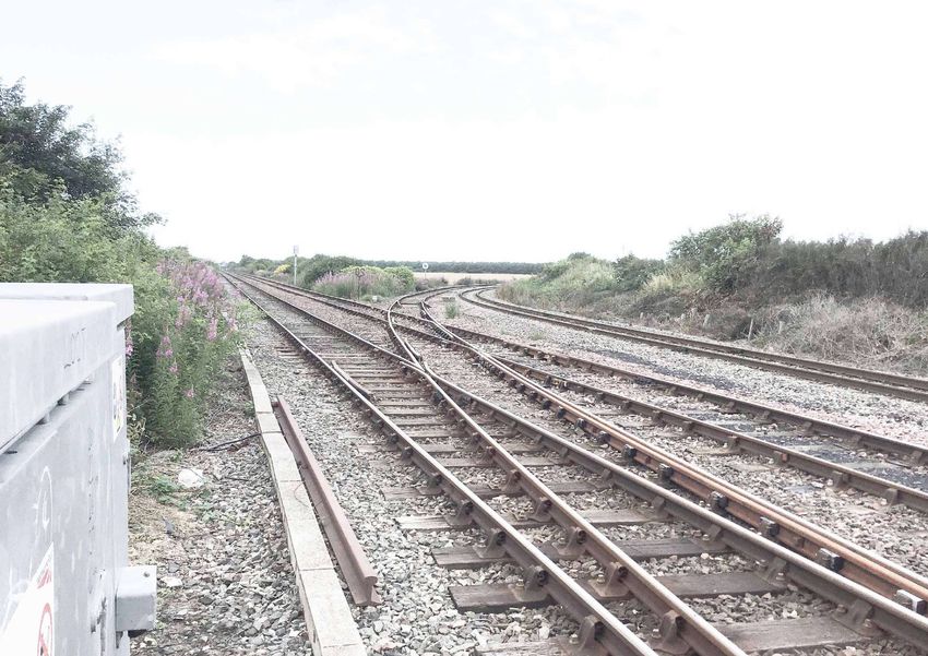
24 25North Seaton Viaduct to
Bedlington ViaductNorth Seaton Viaduct to Bedlington station
Bedlington Viaduct
Bedlington station will be the first stop for Effects of the proposals
trains leaving Ashington and will have two
Between North Seaton Viaduct and The key changes and some local platforms, one for services to Ashington The new station will allow people
Bedlington Viaduct, there will be: landmarks are shown in the map below and one for services to Newcastle. It will living in Bedlington to easily travel into
and are explained in more detail over have all the facilities described on page 13 neighbouring towns, Newcastle and
• a new train station at Bedlington; the following pages. In addition to these of this booklet. further afield using public transport.
changes, engineering works will take place Relative to existing public transport
• changes at various level crossings; and along the railway. In order to meet the predicted demand options, it will be quicker and easier
for passenger services some additional to travel from Bedlington to these
• sites that may need to be temporarily parking will be needed at the station, destinations using the Northumberland
used for construction of the station including Blue Badge spaces and Electric Line, as well as providing an appealing
and other engineering works. Vehicle (EV) charging bays. We are alternative to private car use.
currently considering different options to
Key
meet this demand, which are illustrated on As land in private ownership will be
the plans on the following pages. needed to build the station, negotiations
01 Key features
West with landowners are ongoing and may
These options include: inform further development of the design.
Sleekburn Northumberland Line route
We will seek to reduce the extent of
Green space • a new car park at the junction of additional land required as far as possible.
Barrington Road and Park Terrace;
Roads Some existing trees and green space
Equipment and boundary fencing at
• a new car park on the public open space may have to be removed to construct the
Marcheys House level crossing replaced at the junction of Barrington Road and station and car park. As noted on page 83,
01 and upgraded. This work may involve some Ravensworth Street; and new planting in alternative locations will
03 weekend closures whilst the new equipment compensate for this.
is commissioned
• a new car park on the site of the
existing container storage business off Indicative plans showing our proposals
Bomarsund footpath level crossing to remain Barrington Road. for Bedlington station and car park are
02 02 unchanged, but separate private vehicle
level crossing to be closed Further studies into the suitability of these shown on the following two pages.
options are ongoing. The station and car
03 Closure of Bomarsund private level crossing park will include tree planting and wildlife
friendly landscaping. Some minor works
Closure of Red Row Bridge private footpath
04 04 level crossing
are required to both the level crossings
close to the station. In particular, the road
Minor works to realign the highway will be re-prioritised at Bedlington South
05 and resurface Bedlington North level level crossing, creating a through route
crossing, with a new power supply building from Station Road to Palace Road/Street
constructed adjacent to the crossing into St Johns Road. People will use this
Bedlington North Wicket Gate crossing (no
level crossing to interchange between the
06 06 two station platforms.
changes proposed)
07 New boundary fencing will be installed to
07 New twin platform station at Bedlington
05 keep the station secure, and to provide
08 screening for residential properties and
08 Highways remodelling at Bedlington South businesses where necessary. No works are
crossing, as part of station works
proposed to the signal box at the station,
Furnace Way sidings reinstated to allow and no changes are currently proposed to
09 freight trains to run around and continue the former station buildings on the site.
towards Morpeth and beyond. This currently
happens at Newsham but will no longer To build and safely operate the station,
09 be viable once a more frequent passenger some land in private ownership is required.
0 50 250 500m service is introduced. Works here will include This includes a vacant shop opposite the
creation of two new tracks adjacent to the signal box on Station Road, which will be
main line demolished to provide a new safe and
Figure 10: Bedlington Viaduct
Figure 9: Works proposed between North Seaton Viaduct attractive pedestrian entrance to the
and Bedlington Viaduct station.
28 29Figure 11: Proposed layout for Bedlington station 30 31
Figure 12: Alternative to Ravensworth Road car park

                                                                                             This page has been intentionally left blank

Construction

Our construction strategy is still being
formulated, and dates and durations for               We want to hear your views
the construction of Bedlington station are
still to be confirmed. Information about              We are seeking your views on our
how construction will be managed to                   proposals for Bedlington station,
minimise disturbance to local residents               including any ways in which you feel
and businesses is included on page 83 of              they could be improved. You can
this booklet.                                         share your comments by answering
                                                      the dedicated question on our
Our current plans include construction                response form.
traffic accessing the station site from
Barrington Road and Park Terrace.                     Your feedback will be used to review
Engineering works will take place at both             the current proposals and inform
level crossings, and at these times the               the detailed designs. You will have
crossings and roads may be closed to                  a further opportunity to comment
pedestrians and vehicles.                             on the planning application for
                                                      Bedlington station when it is
Some temporary diversions and changes                 submitted to the Local Planning
to the local highways and footpaths may               Authority.
also be needed.

32                                                                                                                                         33
How we will deliver West
Sleekburn
This section of the line contains six
potential sites which may be temporarily Key
required for construction and engineering 01
works. These sites and the ways they may Northumberland Line route
be used are described on the following
map. The proposed site for Bedlington Potential temporary work sites
station will be used as a construction site
for the station itself. Green space
Feedback from this consultation will help Roads
determine which sites will be used. These
sites may be used to store materials, Marcheys House level crossing 02
machinery and equipment, and to provide Current use: agricultural field
Potential use: construction site for
welfare (e.g. toilets, kitchen) and parking 01
engineering operations to the line and
for contractors. minor works to the Marcheys House level
crossing
It may be necessary to temporarily close
some paths and bridleways to allow
Bomarsund
the sites to be used by our contractors. Current use: agricultural field
Where a public right of way or publicly Potential use: site for engineering 02 03
used path will be temporarily impacted operations to the line
during the construction of the scheme,
efforts will be made to provide temporary Bomarsund level crossings
diversions. Where this is not possible or Current use: scrub woodland
not considered necessary, the duration of Potential use: construction site for changes to
Bomarsund crossings 03
any closures will be kept to a minimum.
Additional information: the level crossing may
need to be closed whilst works take place
Site off A1147
We want to hear your views Current use: cleared land adjacent to an 04
existing business, within an established
If you have any comments about the industrial estate (T T Electronics Welwyn 04
Components Ltd)
proposed temporary use of these Potential use: construction site for
sites, please respond to the relevant engineering works to the line
question on our response form and 05
state the name of the site/s as given Bedlington station
in this booklet. Current use: storage and other
businesses operate from the site, which
Your feedback will be used to review is within the boundary of the planning
the current proposals and inform application for Bedlington station 05
our construction strategy. Once the Potential use: construction site for
Bedlington station and track renewals.
proposals are more certain, further The site could then become part of the car
opportunity to provide comments park for the station
06
will be given to those who may be
affected by the use of the sites. Furnace Way Sidings
Current use: disused railway sidings
Potential use: this site will be upgraded and
become operational rail sidings as part of the
Northumberland Line. The sidings may be used
for overnight parking of trains and driver welfare 06
and other facilities. The sidings are likely to 0 50 250 500m
be used as a construction site for engineering
works to the line. Once operational, there will
be an increase in activity, including noise from
the sidings and in the vehicular traffic using the Figure 13: Map showing potential temporary work sites
Network Rail access from Melrose Court.
34 35Bedlington Viaduct to Blyth
BebsideBedlington Viaduct to Blyth Blyth Bebside station and
Bebside proposed new pedestrian and
cycle bridge
Between Bedlington Viaduct and Blyth The key changes and some local
Bebside, there will be: landmarks are shown in the map below Blyth Bebside station will be the second Effects of the proposals
and are explained in more detail over stop for trains leaving Ashington and
• a new train station at Blyth Bebside; the following pages. In addition to these will have two platforms, one for services The new station will allow people living
changes, engineering works will take to Ashington and one for services to in Blyth to easily use public transport to
• changes to one level crossing; and place along the railway. Newcastle. It will have all the facilities travel to neighbouring towns, Newcastle
described on page 13 of this booklet. and further afield, as well allowing people
• one site that may need to be
temporarily used for construction. The proposed station site is south of living towards Newcastle or Ashington to
residential properties on Heather Lea, and travel to work in Blyth.
is a former colliery tip that has already It will also allow for improved public
been partially reclaimed. The station transport, cycle and pedestrian access
location has moved further south since our to the station location and surrounding
01 River Blyth previous consultation to lessen impacts on areas. Journey times on the new line
the highway network, namely the existing between Blyth and these destinations will
grade separated junction between the be quicker than existing public transport
A189 and the A193. The current proposed options, and will provide an appealing
location has better access from the main alternative to private car use.
road and is further away from the high
voltage overhead power lines. In addition, Blyth is part of an investment
zone focused on offshore energy and
Pedestrian and vehicle access to the marine engineering and is home to the
station will be along a widened and Port of Blyth. The Northumberland Line
upgraded Errington Street from Front will help support the delivery of significant
Street, where a new widened junction will growth in these sectors, as well as the
be constructed. A station footbridge will regeneration of Blyth town centre.
provide access between the platforms. It
will have stairs and lifts on both sides. A As land in private ownership will be
new pedestrian and cycle bridge over the needed to build the station, negotiations
Key A189 will also be provided. with landowners are ongoing and may
02 inform further development of the design.
Key features There will also be a new path linking
We will seek to reduce the extent of
the station to Heather Lea, providing an
Northumberland Line route additional land required as far as possible.
additional pedestrian access to the station.
Green space Indicative plans showing our proposals
The car park will have both Blue Badge
for Blyth Bebside station and car park
Roads spaces and Electric Vehicle (EV) charging
are shown on the following two pages.
04 bays.
01 Bedlington Viaduct (no works proposed) The station, car park and access road will
03 include tree planting and wildlife friendly
Upgrade to Blyth Bebside level crossing. landscaping.
02
For more information, see page 45 New boundary fencing will be installed
to keep the station secure and to provide
New twin platform station at Blyth screening for residential properties and
03 Bebside businesses where necessary.
04 New A189 pedestrian and cycle bridge
0 50 150 300m
Potential temporary work site
Figure 14: Works proposed between Bedlington Viaduct and Blyth
Bebside
38 39Operational access to railway
Key
Platform Emergency exit from
station platform
Platform edge Embankment to platform
at lower level
Platform entrance
Platform shelter New bus stop Drop off (taxi & public) Ramped access from
Platform seating the east of the platform
Planted slope to provide
Lift access to new platforms Lea
t her screening for properties Bridge between
To A
Hea
Footpaths and pedestrian areas on Heather Lea station platforms,
s
hing
Road with lift and stair
Crossing point without traffic lights access on both
ton
Pedestrian access
Cycle storage shelter from Heather Lea sides
Hedge
Sustainable urban drainage feature
Planting and landscaping
Residential fenceline
Railway fenceline
Platform fenceline
tors
h Mo
Blyt
Erri
ngt
on
Stre
To N
et
ewc
Car park with 282 spaces
astl
e
Start of bus and
taxi loop, with access
for bus stops and Ramp and stair access
drop-off to platforms via station
footbridge
Segregated cycleway Potential location Operational access to railway
for new substation
Stairs for pedestrian access from the
Blue Badge parking spaces east of the platform
N EV charging bays
Figure 15: Proposed layout for Blyth Bebside station
40 41Figure 16: Blyth Bebside station access and new foot and cycle bridge 42 43
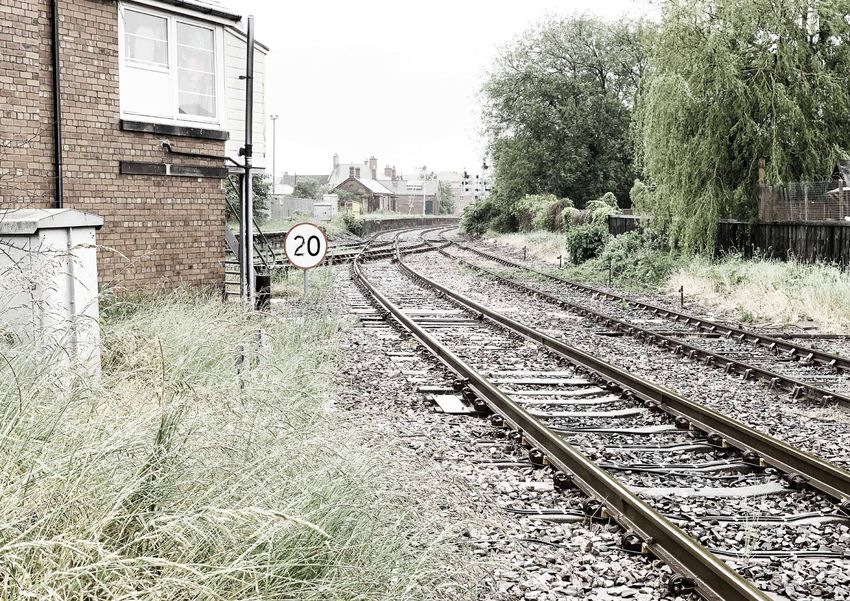
Bebside level crossing How we will deliver
Bebside level crossing is on Front Street, There is one potential temporary work
close to the junction between the A193 site within this section of the scheme,
and the A189. It enables pedestrians and shown on the map on page 38. This site
vehicles to cross the railway line. is currently a grassed area used as an
overflow car park. Access to the site will
As part of the Northumberland Line be via the existing access to the car park
project, the crossing will be upgraded behind the Bebside Inn. The proposed site
to have full barriers across the road for Blyth Bebside station will be used as a
and paths. These barriers will work construction site for the station itself.
automatically and will be able to detect
anyone trespassing into the crossing area Feedback from this consultation will help
when the barriers are down. The barriers determine whether this site will be used.
will also be down for slightly longer than This site may be used to store materials,
they are currently to enable trains to stop machinery and equipment, and to provide
at Blyth Bebside station. Each time the welfare (e.g. toilets, kitchen) and parking
barriers come down, they will remain down for contractors.
for 2 to 3 minutes. New road markings and
signs will be put in place.
We want to hear your views
Figure 17: Example of what the footbridge at Blyth Bebside station could look like. The precise design of the bridge, including what If you have any comments about
shelter will be provided, is still being formulated. Image courtesy of Network Rail the changes proposed at Bebside
level crossing, please respond to the
relevant question on our response
form and reference ‘Bebside level
crossing’ in your answer.
Construction We will use your feedback will be
used to review the current proposals
Our construction strategy is still being for the crossing.
formulated, and dates and durations for We want to hear your views
the construction of Blyth Bebside station
are still to be confirmed. Information We are seeking your views on our
about how construction will be managed proposals for Blyth Bebside station,
to minimise disturbance to local residents including any ways in which you feel
and businesses is included on page 83 of they could be improved. You can
this booklet. share your comments by answering
the dedicated question on our
Our current plans include construction response form.
traffic accessing the station site from Figure 18: Bebside level crossing as it is today
Errington Street. Every effort will be made Your feedback will be used to review
to try and ensure that businesses using the current proposals and inform
Errington Street to access their properties the detailed designs. You will have
are not adversely affected by construction a further opportunity to comment
works. on the planning application for Blyth
Bebside station when it is submitted
Some temporary diversions and changes to the Local Planning Authority.
to the local highways and footpaths may
also be needed.
44 45Chase Meadows, Newsham and New Hartley Curve
Chase Meadows, Newsham Newsham station
and New Hartley Curve
Newsham station will be the third stop for The sections of the existing A1061 which
trains leaving Ashington and will have two are to be closed will be re-used for station
Between Chase Meadows, Newsham Key changes and landmarks are shown in platforms, one for services to Ashington car parks on both the east and west sides
and New Hartley Curve, there will be: the map below and are explained in more and one for services to Newcastle. There of the line, which will include both Blue
detail over the following pages. In addition will be a footbridge with lifts to allow Badge spaces and Electric Vehicle (EV)
• a new train station at Newsham; to these changes, engineering works will passengers to transfer between platforms charging bays.
take place along the railway. and all the facilities described on page
• a new footbridge at Chase Meadows;
13 of this booklet will be provided. The
and
footbridge at this station will be similar
to the one provided at Blyth Bebside, an Effects of the proposals
• sites that may need to be temporarily
used for construction of the station example of which is shown on page 44 of
this booklet. The new station will allow people
and other engineering works. living in Newsham and south Blyth to
Previous designs for this station included easily travel into neighbouring towns,
the retention of the Newsham level Newcastle and further afield using public
01 crossing on the existing alignment of transport. Journey times on the new line
the A1061 (South Newsham Road) with between Newsham, south Blyth and these
the station located to the south of the destinations will be quicker than existing
crossing. public transport options, and will provide
an appealing alternative to private car use.
However, following further technical
assessments and a review of the usage In addition, Blyth is part of an investment
Key of the level crossing, a new design has zone focused on offshore energy and
02
Newsham been developed incorporating a new marine engineering and is home to the
Key features road bridge over the railway and closure Port of Blyth. The Northumberland Line
Northumberland Line route of the Newsham level crossing. This has will help support the delivery of significant
New
Delaval
the benefit of improvements to public growth in these sectors.
Green space safety, better traffic flows along the A1061
and a better and more robust signalling Some woodland, hedgerows, trees
Roads
solution. Future pedestrian and cycle and grassland will need to be removed
to build the station and car park, and
04 Closure of Chase Meadows level
connections into the centre of Blyth could
be investigated as a result of this change allow a diversion of the A1061, but new
03 01 crossing, with public footpath
in design proposal, although they are not landscaping, tree planting and wildlife
diverted over a new footbridge. creation schemes at the station site
05 For more information, see page 53 part of the Northumberland Line scheme.
will compensate for these losses. More
South
Minor upgrades to Plessey Road The new bridge will be single carriageway information about our approach to
Newsham 02 landscaping and environment can be
level crossing and will allow for the diversion of the
A1061 from just west of the junction with found on page 83 of this booklet.
03 Closure of Newsham signal box the B1523 to just east of Blagdon Drive.
This new section of the A1061 will include Land in private ownership will be needed
07 Closure of Newsham level two new roundabouts at the west and to build the station and the new bridge.
04 crossing, with A1061 diverted over
east ends of the new road, which will Negotiations with landowners are ongoing
the line on a new bridge
provide access into the east and west and may inform further development of
New twin platform station at station car parks and drop-off zones. The the design. We will seek to reduce the
05 Newsham roundabout with the B1523 will include extent of additional land required as far as
a junction for a new access road serving possible.
Closure of Lysdon Farm level
the east side of Railway Cottages, and a
crossing, and proposed An indicative plan showing our
06 junction maintaining access to Blagdon
06 diversion of public footpath via proposals for Newsham station and car
Drive. The new section of the A1061 will
nearby underbridge. For more park is shown on the following page.
information, see page 56 be approximately 500m long and will be
New
Hartley
a direct replacement of the existing road.
0 100 300 600m
07 Hartley to Newsham track dualling Provision will be made for a cycleway as
part of the diversion of the A1061.
Figure 19: Works proposed between Chase Meadows, Newsham and New
Hartley Curve
48 49Due to significant local constraints requiring further consideration,
we are still in the process of developing the detailed designs for Roundabout providing
the two car parks at Newsham station. Both car parks will have access to local roads and
Blue Badge parking spaces and EV charging bays, as well as taxi and station car park
public drop-off areas and bus connections. Existing bus stops will
be kept or relocated as part of our plans.
New access to local housing
Bla
We are aware of the importance of the existing cycle and walking
gd
on
routes along the existing road network and across Newsham level
DR
crossing, and will provide replacements for these in our detailed
ive
design.
If you have any comments on our indicative proposals or if there
To A
is anything else you would like to see included in the detailed design,
please indicate this in your response to the questions in section
shin
4 of our response form.
gto
n
Station footbridge, with lifts and stairs
on both sides providing access
between platforms / car parks
Car park for services
Newsham level crossing, towards Newcastle
Access to properties will be maintained. which will be closed
Discussions are ongoing with local New access to
residents about the design for this local property
Roundabout providing
access to local roads and
station car park
Car park for services
towards Ashington
Platform for services towards Key
Ashington, with ramp and
stair access Planting and landscaping
Compensatory planting
Platform for services towards for biodiversity net gain
Newcastle, with ramp and Road
stair access
Footpaths and
A1601 pedestrian areas
Platform
To N
ewc
Replacement overbridge and road Platform edge
astl Bridge
New track to be laid to enable two e
Lift access to new
sets of tracks to run through station
platforms
Figure 20: Proposed layout for Newsham station Fence
50 51Construction Chase Meadows footbridge
Our construction strategy is still being
formulated, and dates and durations for The existing Chase Meadows level Construction
the construction of Newsham station are crossing provides pedestrian only access
still to be confirmed. Information about for footpath 300/178 across the railway Our construction strategy is still being
how construction will be managed to line to the west of Chase Meadows in formulated, and dates and durations
minimise disturbance to local residents Blyth. The introduction of faster and more for the construction of Chase Meadows
and businesses is included on page 83 of frequent trains on the line means that the footbridge are still to be confirmed.
this booklet. existing crossing will need to be closed Information about how construction will be
for safety reasons. It will be replaced with managed to minimise disturbance to local
Our current plans include construction a stepped footbridge, providing a safer residents and businesses is included on
traffic accessing the station site at two crossing for pedestrians. The bridge has page 83 of this booklet.
locations off the existing A1061, both on been designed to minimise any effects
the east and west of the line. on nearby residential properties and their Our current plans include construction
gardens. This includes screening panels traffic accessing the site along the
Once the bridge (see following pages), in the bridge and tree planting to avoid bridleway (no. 300/013) from the
the diverted A1061 and new junctions are properties being overlooked by people roundabout at Chase Farm Drive /
completed then Newsham level crossing using the bridge. Haggerston Road.
will be closed. However, engineering
works will take place at the level crossing We will try and ensure that residents and
during the construction period and so it users of the bridleway are not adversely
may be occasionally closed to vehicular Effects of the proposals affected by construction works. Should
and pedestrian traffic, meaning there this not be possible, the duration of any
may be some temporary diversions and A small area of trees will need to be closures will be kept as short as possible.
other changes to the local highways and removed on both the east and west
side of the line to allow the bridge to be An indicative plan showing our
footpaths during construction. The site will
constructed. These trees will be replaced proposals for Chase Meadows
be fenced, and kept safe and secure at all
as part of the landscaping for the new footbridge is shown on the following
times.
bridge, and this will include the restoration page.
of all paths and bridleways which may be
affected by the construction and access of
vehicles. We want to hear your views
We want to hear your views
As land in private ownership will be
We are seeking your views on our needed to build the bridge, including We are seeking your views on our
proposals for Newsham station open space to its east, negotiations with proposals for Chase Meadows
and the proposed road bridge, landowners are ongoing and may inform footbridge, including any ways
including any ways in which you feel further development of the design. We in which you feel they could be
they could be improved. You can will seek to reduce the extent of additional improved. You can share your
share your comments by answering land required as far as possible. comments by answering the
the dedicated questions on our dedicated question on our response
response form. form.
Your feedback will be used to review Your feedback will be used to review
the current proposals and inform the current proposals and inform
the detailed designs. You will have the detailed designs. You will have
a further opportunity to comment a further opportunity to comment
on the planning application on the planning application for
for Newsham station when it is Chase Meadows footbridge when it
submitted to the Local Planning is submitted to the Local Planning
Authority. Authority.
52 53Figure 21: Proposed footbridge at Chase Meadows 54 55
Lysdon Farm level crossing
The existing footpath (300/049), which
crosses the line at Lysdon Farm, needs to
be closed and diverted for safety reasons.
There is an existing footpath 100 metres
north of the existing crossing. We are
proposing to divert the footpath along
the west side of the line for approximately
100 metres and then connecting with
the existing footpath, which crosses the
railway through the existing underbridge.

Effects of the proposals

The diversion of the footpath will make
the route slightly longer but safer. It will
also mean that users will not need to walk
through the farmyard. Some existing trees
and scrub will need to be removed to
construct the new footpath, but careful
consideration will be given to landscaping
to make sure the path is pleasant to use.
Northumberland County Council are
in negotiations to acquire the rights
necessary for the diversion and the
crossing will remain open until the
diversion is completed.

     We want to hear your views
     If you have any comments about the
     changes proposed at Lysdon Farm
     level crossing, please respond to the
     relevant question on our response
     form and reference ‘Lysdon Farm
     level crossing’ in your answer.
     Your feedback will be used to
     review the current proposals for the
     crossing.

56                                             57
How we will deliver
This section of the line contains three
potential sites which may be temporarily
required for construction and engineering
works. These sites and the ways they may
be used are described on the following
map.
Feedback from this consultation will help
determine which sites will be used. These
sites may be used to store materials,
machinery and equipment, and to provide
welfare (e.g. toilets, kitchen) and parking
Newsham
01
for contractors.
It may be necessary to temporarily close
some paths and bridleways to allow
the sites to be used by our contractors. New Delaval 02
Where a public right of way or publicly
used path will be temporarily impacted
during the construction of the scheme,
efforts will be made to provide temporary
diversions. Where this is not possible or
not considered necessary, the duration of
any closures will be kept to a minimum.
Key
Northumberland Line route
We want to hear your views
Green space
If you have any comments about the
Roads South
proposed temporary use of these Newsham
sites or diversions of public rights of Potential temporary work sites
way, please respond to the relevant
question on our response form and Plessey Road level crossing
state the name of the site/s as given Current use: grassed area between
in this booklet. housing and Plessey Road
01
Potential use: construction site for minor
Your feedback will be used to review works to Plessey Road level crossing
the current proposals and inform
our construction strategy. Once the Plessey Road
Current use: former sidings and former
proposals are more certain, further Blyth railway line, as well as grassed area
opportunity to provide comments adjacent to Plessy Road 02 03
will be given to those who may be Potential use: construction site for
affected by the use of the sites. engineering works to be carried out on
the line
Lysdon Burn
Current use: agricultural field and parking
Potential use: construction site for works
associated with the closure of Lysdon Farm
03
level crossing and the permanent diversion
of the public right of way 300/049. For
more information, see page 56. 0 100 300 600m
Figure 22: Map showing potential temporary work sites
58 59New Hartley Curve to
HolywellNew Hartley Curve to Seaton Delaval station
Holywell
Seaton Delaval station will be the fourth Effects of the proposals
stop for trains leaving Ashington. It will
Between New Hartley Curve and The key changes are shown in the map have a single platform located to the The new station will allow people living
Holywell, there will be: below and are explained in more detail south east of the existing railway line in Seaton Delaval to easily travel into
over the following pages. In addition to and the A192 bridge, and all the facilities neighbouring towns, Newcastle and
• a new train station at Seaton Delaval; these changes, engineering works will take described on page 13 of this booklet will further afield using public transport.
place along the railway. be provided. Journey times on the new line between
• changes at three level crossings; and
Seaton Delaval and these destinations will
Pedestrian access to the station will be be quicker than existing public transport
• sites that may need to be temporarily
along the line of the existing footpath, options, and will provide an appealing
used for construction of the station
which leads from the bridge to Seghill. alternative to private car use.
and other engineering works.
A new road will be constructed from the
A192 adjacent to the existing car park The Northumberland Line proposals
entrance of The Hastings Arms to provide also complement wider development in
access into the station. This road will be a Seaton Delaval, including a major new
New primary pedestrian and cycle access route employment site being taken forward
Hartley to the station, with new lighting installed by Vbites, which may provide new
to improve safety. The station will be employment opportunities for local
connected with the existing public open people.
01 space and footpath network in Whytrigg
Close and Wheatridge. The land needed for the station and
car park includes part of a small area of
In order to meet the predicted demand for woodland, a grazing field and hedgerows.
passenger services, safe and convenient To compensate for the loss of these
parking will be needed. The station features, as well as to provide an attractive
parking will be located on the south east environment, the station and car park will
side of the existing railway line and will include tree planting and wildlife friendly
include a car park with Blue Badge spaces landscaping. A small wetland area will
and Electric Vehicle (EV) charging bays. be provided on land to the south of the
Key proposed car park designed to control the
02
New boundary fencing will be installed risk of flooding and provide a breeding
Key features to keep the station secure and to provide and foraging habitat for wildlife such as
screening for residential properties where amphibians, birds and bats.
Northumberland Line route
necessary.
Green space As land in private ownership will be
03 needed to build the station and access
Roads road, negotiations with landowners
are ongoing and may inform further
Upgrade to Hartley development of the design. We will seek
01 level crossing. For more to reduce the extent of additional land
information, see page 67 required as far as possible.
04
An indicative plan showing our
New single platform station
02 at Seaton Delaval
proposals for Seaton Delaval station
and car park is shown on the following
page.
Mares Close level crossing.
03 For more information, see
page 67
0 100 300 600m
Upgrade to Seghill
04 level crossing. For more
information, see page 67
Figure 23: Works proposed between New Hartley Curve and Holywell
62 63You can also read