OFFSHORE OIL & GAS LICENSING 31ST SEAWARD ROUND - Habitats Regulations Assessment Appropriate Assessment: Irish Sea
←
→
Page content transcription
If your browser does not render page correctly, please read the page content below
OFFSHORE OIL & GAS
LICENSING
  ST
31 SEAWARD
ROUND
Habitats Regulations Assessment
Appropriate Assessment: Irish Sea

April 2019
© Crown copyright 2019

This publication is licensed under the terms of the Open Government Licence v3.0
except where otherwise stated.

To view this licence, visit nationalarchives.gov.uk/doc/open-government-
licence/version/3 or write to the Information Policy Team, The National Archives, Kew,
London TW9 4DU, or email: psi@nationalarchives.gsi.gov.uk.

Any enquiries regarding this publication should be sent to us at oep@beis.gov.uk.
Potential Award of Blocks in the 31st Seaward Licensing Round: Appropriate Assessment

Contents

1    Introduction _______________________________________________________ 1
    1.1   Background and purpose _________________________________________ 1
    1.2   Relevant Blocks ________________________________________________ 2
    1.3   Relevant Natura 2000 sites ________________________________________ 3
    1.4   Assessment overview ____________________________________________ 5
2    Licensing and potential activities _______________________________________ 7
    2.1   Licensing ______________________________________________________ 7
    2.2   Activities that could follow licensing _________________________________ 8
    2.3   Existing regulatory requirements and controls _________________________ 20
3    Appropriate assessment process ______________________________________ 22
    3.1   Process _______________________________________________________ 22
    3.2   Site integrity ___________________________________________________ 22
    3.3   Assessment of effects on site integrity _______________________________ 23
4    Evidence base for assessment ________________________________________ 24
    4.1   Introduction ____________________________________________________ 24
    4.2   Physical disturbance and drilling effects ______________________________ 25
    4.3   Underwater noise effects _________________________________________ 31
5    Assessment ______________________________________________________ 40
    5.1   Relevant sites __________________________________________________ 40
    5.2   Assessment of physical disturbance and drilling effects __________________ 47
    5.3   Assessment of underwater noise effects______________________________ 62
    5.4   In-combination effects ____________________________________________ 73
6    Overall conclusion __________________________________________________ 86
7    References _______________________________________________________ 86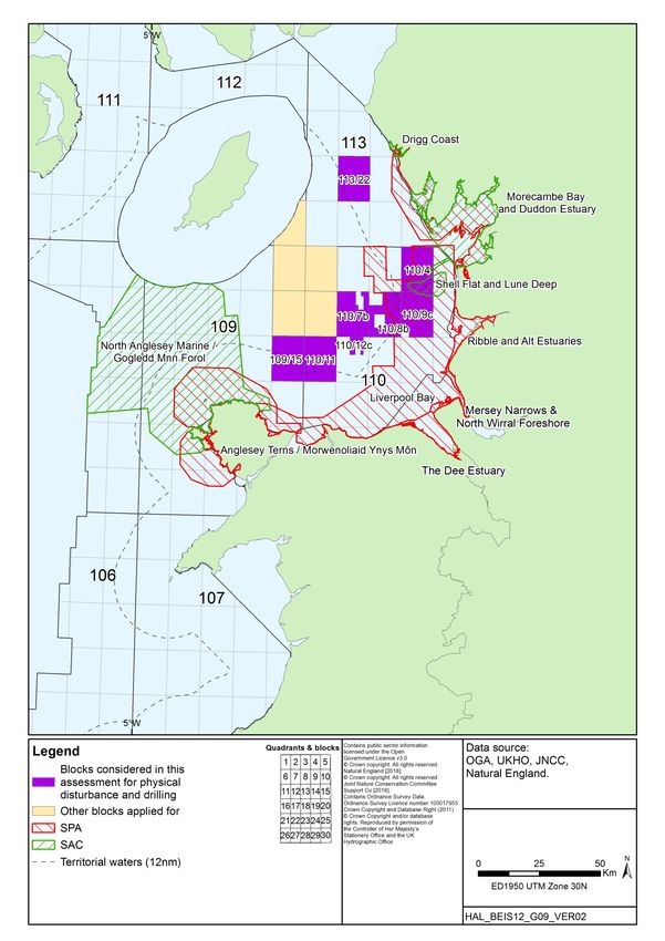
Potential Award of Blocks in the 31st Seaward Licensing Round: Appropriate Assessment

1                       Introduction

1.1                     Background and purpose
The plan/programme covering this and potential future seaward licensing rounds has been
subject to a Strategic Environmental Assessment (OESEA3), completed in July 2016. The
SEA Environmental Report includes detailed consideration of the status of the natural
environment and potential effects of the range of activities which could follow licensing,
including potential effects on conservation sites. The SEA Environmental Report was subject
to an 8-week public consultation period, and a post-consultation report summarising comments
and factual responses was produced as an input to the decision to adopt the plan/programme.
This decision has allowed the Oil & Gas Authority (OGA) to progress with further seaward oil
and gas licensing rounds. As a result, on 10th July 2018, the OGA invited applications for
licences relating to 1,779 Blocks in a 31st Seaward Licensing Round covering mature and
frontier areas of the UK Continental Shelf (UKCS). Applications were received for licences
covering 164 Blocks/part Blocks.

The Offshore Petroleum Activities (Conservation of Habitats) Regulations 2001 (as amended)
implement the requirements of Articles 6(3) and 6(4) of the Habitats Directive with respect to oil
and gas activities in UK territorial waters and on the UK Continental Shelf. The Conservation
of Offshore Marine Habitats and Species Regulations 2017 cover other relevant activities in
offshore waters (i.e. excluding territorial waters). Within territorial waters, the Habitats
Directive is transposed into UK law via the Conservation of Habitats and Species Regulations
2017 in England and Wales, the Conservation (Natural Habitats, &c.) Regulations 1994 in
Scotland (for non-reserved matters), and the Conservation (Natural Habitats, &c) Regulations
(Northern Ireland) 1995 (as amended) in Northern Ireland.

As the petroleum licensing aspects of the plan/programme are not directly connected with or
necessary for nature conservation management of European (Natura 20001) sites, to comply
with its obligations under the relevant regulations, the Department for Business, Energy and
Industrial Strategy2 (BEIS) is undertaking a Habitats Regulations Assessment (HRA). To
comply with obligations under the Offshore Petroleum Activities (Conservation of Habitats)
Regulations 2001 (as amended), in winter 2018, the Secretary of State undertook a screening
assessment to determine whether the award of any of the Blocks offered would be likely to

1
  This includes Special Areas of Conservation (SAC) and Special Protection Areas (SPA), and potential sites for
which there is adequate information on which to base an assessment.
2
  Note that while certain licensing and regulatory functions were passed to the OGA (a government company
wholly owned by the Secretary of State for BEIS) on 1 October 2016, environmental regulatory functions are
retained by BEIS, and are administered by the Offshore Petroleum Regulator for Environment and
Decommissioning (OPRED).

                                                                                                                  1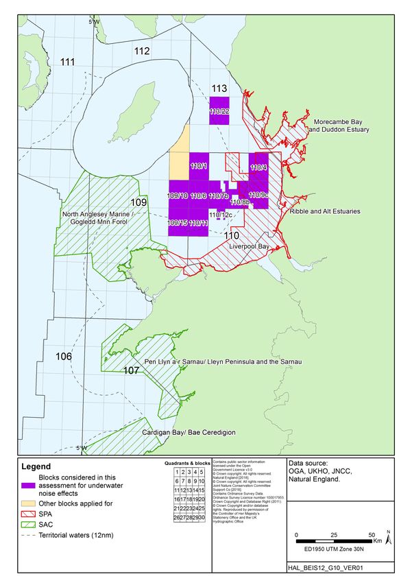
Potential Award of Blocks in the 31st Seaward Licensing Round: Appropriate Assessment
have a significant effect on a relevant site, either individually or in combination3 with other
plans or projects (BEIS 2018a). In doing so, BEIS has applied the Habitats Directive test4
(elucidated by the European Court of Justice in the case of Waddenzee (Case C-127/02)5)
which is:
…any plan or project not directly connected with or necessary to the management of the
site is to be subject to an appropriate assessment of its implications for the site in view
of the site's conservation objectives if it cannot be excluded, on the basis of objective
information, that it will have a significant effect on that site, either individually or in
combination with other plans or projects.
…where a plan or project not directly connected with or necessary to the management
of a site is likely to undermine the site’s conservation objectives, it must be considered
likely to have a significant effect on that site. The assessment of that risk must be made
in the light inter alia of the characteristics and specific environmental conditions of the
site concerned by such a plan or project.
1.2 Relevant Blocks
The screening assessment (including consultation with the statutory conservation
agencies/bodies) formed the first stage of the HRA process. The assessment was undertaken
in the period within which applications for Blocks were being accepted, and therefore
considered all 1,779 Blocks offered. The screening identified 525 whole or part Blocks as
requiring further assessment prior to decisions on whether to grant licences (BEIS 2018a).
Following the closing date for 31st Seaward Round applications, and the publication of the
screening document, those Blocks identified as requiring further assessment were
reconsidered against the list of actual applications. It was concluded that further assessment
(Appropriate Assessment, AA) was required for 41 of the Blocks applied for. Because of the
wide distribution of these Blocks around the UKCS, the AAs are documented in four regional
reports as follows:
Mid North Sea High
Moray Firth
Irish Sea
3
Note that “in-combination” and “cumulative” effects have similar meanings, but for the purposes of HRA, and in
keeping with the wording of Article 6(3) of the Habitats Directive, “in-combination” is used to describe the potential
for such effects throughout. More information on the definitions of “cumulative” and “in-combination” effects are
available in MMO (2014) and Judd et al. (2015).
4
See Article 6(3) of the Habitats Directive.
5
Also see the Advocate General’s Opinion in the recent ‘Sweetman’ case (Case C-258/11), which confirms those
principles set out in the Waddenzee judgement.
2Potential Award of Blocks in the 31st Seaward Licensing Round: Appropriate Assessment
English Channel
1.2.1 Irish Sea Blocks
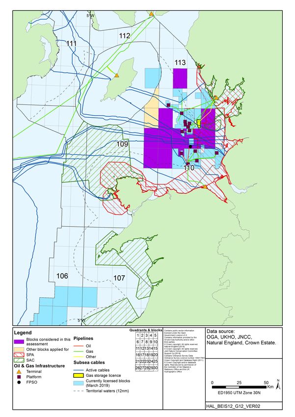
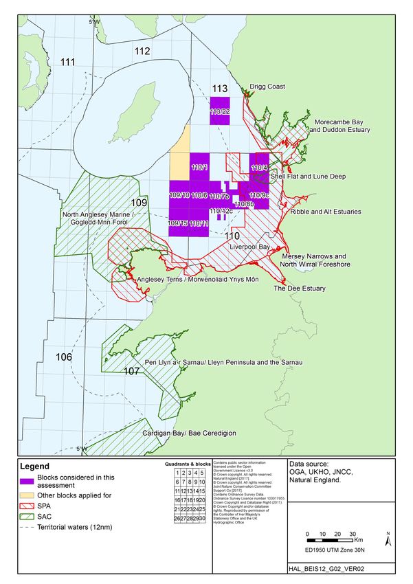
The Irish Sea Blocks applied for in the 31st Round and considered in this assessment are listed
below in Table 1.1, and are shown in Figure 1.1.
Table 1.1: Blocks requiring further assessment
109/10 109/15 110/1 110/4 110/6
110/7b 110/8b 110/9c 110/11 110/12c
113/22
1.3 Relevant Natura 2000 sites
The screening identified the relevant Natura 2000 sites and related Blocks requiring further
assessment in the Irish Sea (refer to Appendix B of BEIS 2018a). Following a reconsideration
of those Blocks and sites screened in against those Blocks applied for, 12 Natura 2000 sites
were identified as requiring further assessment in relation to 11 Blocks (Table 1.2 and Figure
1.1). Abbreviations and species common names follow those in Appendix A of BEIS (2018a).
Table 1.2: Relevant sites requiring further assessment
Relevant site Relevant Blocks Potential effects
Features applied for
Special Protection Areas (SPAs)
Morecambe Bay and Duddon Estuary SPA 110/4, 110/9c, 113/22 Underwater noise
Breeding: common tern, sandwich tern, little 110/4, 113/22 Physical disturbance and drilling
tern
Over winter: whooper swan, little egret, golden
plover, ruff, bar-tailed godwit, Mediterranean
gull, lesser black-backed gull, herring gull;
On passage: pink-footed goose, shelduck,
oystercatcher, ringed plover, grey plover, knot,
sanderling, dunlin, black-tailed godwit, curlew,
pintail, turnstone, redshank, lesser black-backed
gull.
Seabird and waterbird assemblage all year
round
Ribble and Alt Estuaries SPA 110/4, 110/9c Underwater noise
Breeding: common tern, ruff
On passage: ringed plover, sanderling,
redshank, whimbrel; 110/9c Physical disturbance and drilling
Over winter: bar-tailed godwit, Bewick's swan,
golden plover, whooper swan, lesser black-
backed gull, black-headed gull pintail, teal,
wigeon, pink-footed goose, scaup, sanderling,
dunlin, knot, oystercatcher, black-tailed godwit,
common scoter, curlew, cormorant, grey plover,
shelduck, redshank, lapwing.
Breeding seabird and overwintering waterbird
assemblages
Liverpool Bay SPA 109/15, 110/1, 110/4, Underwater noise
Breeding: little tern, common tern 110/6, 110/7b, 110/8b,
Over winter: red-throated diver, little gull, 110/9c, 110/11, 110/12c
3Potential Award of Blocks in the 31st Seaward Licensing Round: Appropriate Assessment
Relevant site Relevant Blocks Potential effects
Features applied for
common scoter 109/15, 110/4, 110/7b, Physical disturbance and drilling
Wintering waterbird assemblage 110/8b, 110/9c, 110/11,
110/12c
Mersey Narrows and North Wirral Foreshore 109/15, 110/4, 110/7b, Physical disturbance and drilling
SPA 110/8b, 110/9c, 110/11,
Breeding: common tern 110/12c
On passage: little gull, common tern
Over winter: bar-tailed godwit, knot
Wintering waterbird assemblage
The Dee Estuary SPA 109/15, 110/4, 110/7b, Physical disturbance and drilling
Breeding: common tern, little tern 110/8b, 110/9c, 110/11,
On passage: Sandwich tern, redshank 110/12c
Over winter: bar-tailed godwit, pintail, teal,
dunlin, knot, oystercatcher, black-tailed godwit,
curlew, grey plover, shelduck, redshank
Wintering waterbird assemblage
Anglesey Terns / Morwenoliaid Ynys Môn 109/15 Physical disturbance and drilling
SPA
Breeding: roseate tern, common tern, Arctic
tern, Sandwich tern
Special Areas of Conservation (SACs)
Drigg Coast SAC 113/22 Physical disturbance and drilling
Annex I habitat: estuaries, coastal dunes,
mudflats and sandflats, saltmarsh and salt
meadows, coastal dunes
Morecambe Bay SAC 110/4 Physical disturbance and drilling
Annex I habitat: estuaries, mudflats and
sandflats, inlets and bays, vegetation of stony
banks, saltmarsh and salt meadows, coastal
dunes, sandbanks, coastal lagoons, reefs,
coastal dunes
Shell Flat and Lune Deep SAC 110/4, 110/8b, 110/9c Physical disturbance and drilling
Annex I habitat: reefs
North Anglesey Marine / Gogledd Môn Forol 109/10, 109/15 Underwater noise
SAC
Annex II species: harbour porpoise
109/15 Physical disturbance and drilling
Pen Llyn a`r Sarnau/ Lleyn Peninsula and the 109/15 Underwater noise
Sarnau SAC
Annex I habitats: sandbanks, estuaries, coastal
lagoons, inlets and bays, reefs, mudflats and
sandflats, saltmarsh and salt meadows, sea
caves
Annex II species: bottlenose dolphin, otter, grey
seal
Cardigan Bay/ Bae Ceredigion SAC 109/15 Underwater noise
Annex I habitats: sandbanks, reefs, sea caves
Annex II species: sea lamprey, river lamprey,
grey seal, bottlenose dolphin
4Potential Award of Blocks in the 31st Seaward Licensing Round: Appropriate Assessment
1.4 Assessment overview
This document sets out the key assumptions and approach to the AA, the evidence base
underpinning the assessment and the assessment of relevant Blocks and sites. The document
is organised as follows:
Overview of the licensing process and nature of the activities that could follow including
assumptions used to underpin the AA process (Section 2)
Description of the approach to ascertaining the absence or otherwise of adverse effects
on the integrity of relevant European sites (Section 3)
Evidence base on the environmental effects of offshore oil and gas activities to inform the
assessment (Section 4)
The assessment of effects on the integrity of relevant sites, including in-combination with
other plans or projects (Sections 5-8)
Overall conclusion (Section 9)
As part of this HRA process, the AA document is being subject to consultation with appropriate
nature conservation bodies and the public and will be amended as appropriate in light of
comments received. The final AA document will be available via the 31st Round Appropriate
Assessment webpage of the gov.uk website.
5Potential Award of Blocks in the 31st Seaward Licensing Round: Appropriate Assessment
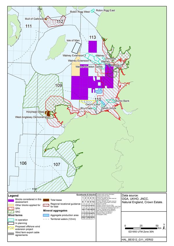
Figure 1.1: Blocks and sites relevant to this Appropriate Assessment
6Potential Award of Blocks in the 31st Seaward Licensing Round: Appropriate Assessment
2 Licensing and potential activities
2.1 Licensing
The exclusive rights to search and bore for petroleum in Great Britain, the territorial sea
adjacent to the United Kingdom and on the UKCS are vested in the Crown and the Petroleum
Act 1998 (as amended) gives the OGA the power to award Seaward Production Licences
which grant exclusive rights to the holders “to search and bore for, and get, petroleum” in the
area covered by the Licence. A Seaward Production Licence does not constitute any form of
approval for activities to take place in the licensed Blocks, nor does it confer any exemption
from other legal or regulatory requirements. Offshore activities that may follow licensing are
subject to a range of statutory permitting and consenting requirements, including, where
relevant, activity specific AA as required under Article 6(3) of the Habitats Directive (Directive
92/43/EC).
Several sub-types of Seaward Production Licence were available in previous rounds
(Traditional, Frontier and Promote) which have been replaced by the single “Innovate” licence 6.
As per previous licensing structures, the Innovate licence is made up of three terms covering
exploration (Initial Term), appraisal and field development planning (Second Term), and
development and production (Third Term). The lengths of the first two terms are flexible but
have a maximum duration of 9 and 6 years respectively. The Third Term is granted for 18
years but may be extended if production continues beyond this period. The Innovate licence
introduces three Phases to the Initial Term, covering:
Phase A: geotechnical studies and geophysical data reprocessing (note that the
acquisition of new seismic could take place in this phase for the purpose of defining a 3D
survey as part of Phase B, but normally this phase will not involve activities in the field)
Phase B: shooting of new seismic and other geophysical data
Phase C: exploration and appraisal drilling
Applicants may propose the Phase combination in their submission to the OGA. Phase A and
Phase B are optional and may not be appropriate in certain circumstances, but every
application must propose a Phase C, except where the applicant does not think any
exploration is needed (e.g. in the development of an existing discovery or field re-development)
and proposes to go straight to development (i.e. ‘straight to Second Term’). The duration of
the Initial Term and the Phases within it are agreed between the OGA and the applicant.
Applicants may choose to spend up to 4 years on a single Phase in the Initial Term but cannot
6
The Petroleum and Offshore Gas Storage and Unloading Licensing (Amendment) Regulations 2017 amend the
Model Clauses to be incorporated in Seaward Production Licences so as to implement the Innovate licences to be
st
issued in the 31 Round.
7Potential Award of Blocks in the 31st Seaward Licensing Round: Appropriate Assessment
take more than 9 years to progress to the Second Term. Failure to complete the work agreed
in a Phase, or to commit to the next Phase means the licence ceases, unless the term has
been extended by the OGA.
Financial viability is considered prior to licence award for applicants proposing to start at Phase
A or B, but further technical and financial capacity for Phase C activities would need to be
demonstrated before the licence could enter Phase C and drilling could commence. If the
applicant proposes to start the licence at Phase C or go straight to the Second Term, the
applicant must demonstrate that it has the technical competence to carry out the activities that
would be permitted under the licence during that term, and the financial capacity to complete
the work programme, before the licence is granted. It is noted that the safety and
environmental capability and track record of all applicants are considered by the OGA (in
consultation with the Offshore Safety Directive Regulator)7 through written submissions before
licences are awarded8.
As part of these written submissions operators must demonstrate that they have the relevant
safety and environmental capabilities to undertake the proposed work programme (e.g.
company environmental policies, awareness of statutory safety and environment provisions,
and has environmental management systems). Where full details cannot be provided in the
written submissions at the application stage, licensees must provide supplementary
submissions that address any outstanding environmental and safety requirements before
approvals for specific offshore activities such as drilling can be issued. In all instances
applicants must submit an environmental sensitivities assessment, demonstrating at the
licence application stage that they are aware of environmental sensitivities relevant to the
Blocks being applied for and the adjacent areas, and understand the potential impacts of the
proposed work programme.
2.2 Activities that could follow licensing
As part of the licence application process, applicants provide the OGA with details of work
programmes they propose in the Initial Term. These work programmes are considered along
with a range of other factors by the OGA before arriving at a decision on whether to license the
Blocks and to whom. Activities detailed in work programmes may include the purchase,
reprocessing or shooting of 2D or 3D seismic data (Phases A and B) and the drilling of wells
(Phase C). There are three levels of drilling commitment:
A Firm Drilling Commitment is a commitment to the OGA to drill a well. Firm drilling
commitments are preferred on the basis that, if there were no such commitment, the OGA
7
The Offshore Safety Directive Regulator is the Competent Authority for the purposes of the Offshore Safety
Directive comprising of the Department for Business, Energy and Industrial Strategy (BEIS) Offshore Petroleum
Regulator for Gas Environment and Decommissioning (OPRED) and the Health and Safety Executive (HSE)
working in partnership.
8
Refer to OGA technical guidance and safety and environmental guidance (Appendix C) on applications for the
st
31 Round at: https://www.ogauthority.co.uk/licensing-consents/licensing-rounds/
8Potential Award of Blocks in the 31st Seaward Licensing Round: Appropriate Assessment
could not be certain that potential licensees would make full use of their licences.
However, the fact that a licensee has been awarded a licence on the basis of a “firm
commitment” to undertake a specific activity should not be taken as meaning that the
licensee will actually be able to carry out that activity. This will depend upon the outcome
of relevant activity specific environmental assessments.
A Contingent Drilling Commitment is also a commitment to the OGA to drill a well, but it
includes specific provision for the OGA to waive the commitment in light of further
technical information.
A Drill or Drop (D/D) Drilling Commitment is a conditional commitment with the proviso
that the licence is relinquished if a well is not drilled.
Note that Drill or Drop and Contingent work programmes (subject to further studies by the
licensees) will probably result in a well being drilled in less than 50% of the cases.
The OGA general guidance9 makes it clear that an award of a Production Licence does not
automatically allow a licensee to carry out any offshore petroleum-related activities from then
on (this includes those activities outlined in initial work programmes, particularly Phases B and
C). Figure 2.1 provides an overview of the plan process associated with the 31st Seaward
Licensing Round and the various environmental assessments including HRA. Offshore
activities such as drilling and seismic survey are subject to relevant activity specific
environmental assessments by BEIS (see Figures 2.2 and 2.3), and there are other regulatory
provisions exercised by the Offshore Safety Directive Regulator and bodies such as the Health
and Safety Executive. It is the licensee’s responsibility to be aware of, and comply with, all
regulatory controls and legal requirements, and work offshore cannot proceed until the relevant
consents/approvals are in place.
The proposed work programmes for the Initial Term are detailed in the licence applications.
For some activities, such as seismic survey, the potential impacts associated with noise could
occur some distance from the licensed Blocks and the degree of activity is not necessarily
proportional to the size or number of Blocks in an area. In the case of direct physical
disturbance, the Blocks being applied for are relevant.
9
https://www.ogauthority.co.uk/media/4950/general-guidance-31st-seaward-licensing-round-july-2018.docx
9Potential Award of Blocks in the 31st Seaward Licensing Round: Appropriate Assessment
Figure 2.1: Stages of plan level environmental assessment
Announcement of a
Key plan/programme to enable
future licensing for oil & gas
Stages of plan/programme for blocks on the UKCS
level assessment (note 1)
Environmental
submissions/consultations/ Early SNCB & stakeholder input (informal & formal scoping,
other relevant inputs Plan/programme subject to expert & stakeholder workshops, Steering Group).
Strategic Environmental SEA subject to formal public consultation.
Assessment (note 2) Research/studies to address data gaps and SEA
Habitats Regulations recommendations
Assessment (HRA) stages
Publication of post consultation
report
Licensing decisions
Adoption of plan/programme &
post adoption statement
Current stage of the HRA process
Licence applicants must provide
Note 1: A summary of Regulatory Announcement of seaward OGA release licensing Round information pack including
a safety and environmental
controls are provided in Appendix 3 of licensing Round. Operators application guidance and list of "other regulatory issues" to
capability submission and a high
DECC (2016), OESEA3 invited to bid for blocks support licence applicant's submission. Spatial information
level environmental sensitivities
released across the UKCS representing existing offshore activities also released.
assessment for Blocks applied for
Note 2: More than 1 licensing round may
be covered by a single SEA if the
geographical or technical scope of the HRA screening undertaken
plan/programme is unchanged, and the for all blocks offered and Consultation with SNCBs on scope and content of
environmental information and context on screening report published screening document
which the SEA is based has not
appreciably changed. BEIS undertook a
review of OESEA3 in 2018 and Likely Significant Effects
Blocks released for identified for relevant sites in
concluded that new information and licensing if applied No
updates published since OESEA3 have relation to certain Blocks
for offered
not significantly changed the policy and
technology context of the plan, or the
environmental baseline and
understanding of effects underpinning its Yes
assessment.
Relevant Blocks applied for
subject to Appropriate Consultation with SNCBs, the public and other member
Assessment and draft report states where relevant
published
Appropriate Assessments
amended based on
consultation feedback and final
reports published
Blocks licensed where no
adverse effect on site integrity
predicted (subject to other
conditions and obligations –
see project level requirements)
Activities in all Blocks subject to project specific controls
(see Figures 2.3 and 2.4)
10Potential Award of Blocks in the 31st Seaward Licensing Round: Appropriate Assessment
Figure 2.2: High level overview of exploration drilling environmental requirements
Drilling of a well is proposed
within a licensed Block
The nature or location of A Direction is sought that an
drilling related activities leads ES is not required through a
to the mandatory submission of Drilling Operations Application.
No
a full Environmental Statement SoS decision on whether an
(ES) (note 1) ES is required (note 2)
Yes Yes No
Options BEIS strongly recommend operators early consultation
Full ES undertaken for
appraisal/selection with SNCBs on proposed activities (e.g. scoping).
must consider activities associated with 28 day public consultation period.
drilling. All activities subject
environmental Statutory consultees include SNCBs and other
to further permitting.
implications stakeholders (e.g. MCA)
It is considered by BEIS that
the activities are likely to have BEIS undertake Appropriate Consultation with
a significant effect on a Yes Assessment before a decision SNCBs and the
European site can be taken public.
No
Conclusion of no adverse
Yes effect on site integrity?
No
Well consent cannot be
granted*
Well consent can be granted subject to all regulatory and other requirements having been met as part of a Drilling Operations Application (e.g. requirement to
have in place an approved Oil Pollution Emergency Plan, permit for chemical use and discharge, consent to locate within the UKCS). These
permits/consents/approvals are subject to other regulatory controls and are reviewed by the regulator and its advisors prior to any consent being granted.
Also see note 3
Key
Note 1: See BEIS (2018). The Offshore Petroleum Production and Pipelines (Assessment of Environmental
Stages of project permitting Effects) Regulations 1999 (as amended) – A Guide. The Offshore Petroleum Regulator for Environment and
Decommissioning, 80pp.
Environmental Note 2: Early consultation between BEIS and licensed operators is typical to mitigate against Environmental
submissions/consultations/ Statement (ES) requirements being identified following the request for a direction
other relevant inputs
Note 3: In cases where an ES was initially identified as not required, or where an ES has been approved, the
requirement to undertake AA may still apply (e.g. due to changes in the nature of the project or the designation of
Habitats Regulations additional European sites)
Assessment (HRA) stages
* Article 6(4) of the Habitats Directive provides a derogation which would allow a plan or project to be approved in
limited circumstances even though it would or may have an adverse effect on the integrity of a European site (see:
Permitting/Consenting Defra 2012).
decisions
11Potential Award of Blocks in the 31st Seaward Licensing Round: Appropriate Assessment
Figure 2.3: High level overview of seismic survey environmental requirements
Key
Geological survey (e.g. 2D, 3D
seismic, VSP) is proposed within a Stages of project permitting
licensed Block
Environmental
submissions/consultations/
Survey planning other relevant inputs
(e.g. cetacean sensitivity of the Early consultation with SNCBs
proposed area, periods of concern for and BEIS
seismic) Habitats Regulations
Assessment (HRA) stages
Apply for Marine Survey Consent
Permitting/Consenting
decisions
Location and sound source size such
that an Environmental Impact
Assessment and noise assessment Consultation with SNCBs
are required in support of a Marine
Survey application
It is considered that the activities are BEIS undertake Appropriate
likely to have a significant effect on a Yes Assessment before a decision Consultation with SNCBs
European site can be taken
No
Consent to undertake a marine survey Conclusion of no adverse effect
Yes
granted subject to conditions (note 1) on site integrity?
Note 1: As part of consent condition, operators would be No
required to follow the JNCC guidelines for minimising the
risk of injury to marine mammals from geophysical
surveys (JNCC 2017).
Condition of consent that Seismic Survey Closeout Consent cannot be granted*
Report completed (may include submission of Marine
Mammal Observer and Passive Acoustic Monitoring
reports)
* Article 6(4) of the Habitats Directive provides a
derogation which would allow a plan or project to be
approved in limited circumstances even though it would
or may have an adverse effect on the integrity of a
European site (see: Defra 2012).
12Potential Award of Blocks in the 31st Seaward Licensing Round: Appropriate Assessment
2.2.1 Likely scale of activity
On past experience the activity that actually takes place is less than what is included in the
work programmes at the licence application stage. A proportion of Blocks awarded may be
relinquished without any offshore activities occurring. Activity after the Initial Term is much
harder to predict, as this depends on the results of the initial phase, which is, by definition,
exploratory. Typically, less than half the wells drilled reveal hydrocarbons, and of that, less
than half will have a potential to progress to development. For example, the OGA analysis of
exploration well outcomes from the Moray Firth & Central North Sea between 2003 and 2013
indicated an overall technical success rate of 40% with respect to 150 exploration wells and
side-tracks (Mathieu 2015). Depending on the expected size of finds, there may be further
drilling to appraise the hydrocarbons (appraisal wells). For context, Figure 2.4 highlights the
total number of exploration and appraisal wells started on the UKCS each year since 2000 as
well as the number of significant discoveries made (associated with exploration activities).
Discoveries that progress to development may require further drilling, installation of
infrastructure such as wellheads, pipelines and possibly fixed platform production facilities,
although recent developments are mostly tiebacks to existing production facilities rather than
stand-alone developments. For example, of the 33 relevant projects identified by the OGA’s
Project Pathfinder (as of 5th April 2019)10, 18 are planned as subsea tie-backs to existing
infrastructure, 6 involve new stand-alone production platforms and 5 are likely to be developed
via Floating Production, Storage and Offloading facilities (FPSO). The final form of
development for many of the remaining projects is not decided, with some undergoing re-
evaluation of development options but some are likely to be subsea tie-backs. Figure 2.4
indicates that the number of development wells has declined over time and this pattern is likely
to continue. The nature and scale of potential environmental impacts from the drilling of
development wells are similar to those of exploration and appraisal wells and thus the
screening criteria described in Section 4 are applicable to the potential effects of development
well drilling within any of the 31st Round Blocks.
10
https://itportal.ogauthority.co.uk/eng/fox/path/PATH_REPORTS/pdf
13Potential Award of Blocks in the 31st Seaward Licensing Round: Appropriate Assessment
Figure 2.4: UKCS Exploration, appraisal & development wells, and significant
discoveries since 2000
350
Discoveries
Exploration wells
300
Number of wells started and significant discoveries
Appraisal wells
Development wells
250
200
150
100
50
0
Note: "significant" generally refers to the flow rates that were achieved (or would have been reached)
in well tests (15 mmcfgd or 1000 BOPD) and does not indicate commercial potential of the discovery.
Source: OGA Drilling Activity (February 2019), Significant Offshore Discoveries (October 2018)
2.2.2 31st Round activities considered by the HRA
The nature, extent and timescale of development, if any, which may ultimately result from the
licensing of 31st Round Blocks is uncertain, and therefore it is regarded that at this stage a
meaningful assessment of development level activity (e.g. pipelay, placement of jackets,
subsea templates or floating installations) cannot be made. Once project plans are in place,
subsequent permitting processes relating to exploration, development and decommissioning,
would require assessment including an HRA where appropriate, allowing the opportunity for
further mitigation measures to be identified as necessary, and for permits to be refused if
necessary. In this way the opinion of the Advocate General in ECJ (European Court of
Justice) case C-6/04, on the effects on Natura sites, "must be assessed at every relevant stage
of the procedure to the extent possible on the basis of the precision of the plan. This
assessment is to be updated with increasing specificity in subsequent stages of the procedure"
is addressed. Therefore, only activities as part of the work programmes associated with the
Initial Term and its associated Phases A-C will be considered in this AA (see Table 2.2).
Potential accidental events, including spills, are not considered in the AA as they are not part
of the work plan. Measures to prevent accidental events, response plans and potential
impacts in the receiving environment would be considered as part of the environmental impact
14Potential Award of Blocks in the 31st Seaward Licensing Round: Appropriate Assessment
assessment (EIA) process for specific projects that could follow licensing when the location,
nature and timing of the proposed activities are available to inform a meaningful assessment of
such risks. The EIA would be informed the modelling undertaken for the Oil Pollution
Emergency Plan (OPEP). The OPEP is assessed by BEIS, and a range of organisations, and
other Government departments are consulted by BEIS during the OPEP determination
process. The OPEP includes an assessment of spill risk, response arrangements, and details
of actions, interfaces, training and exercises specific to an installation or operation11. A
comprehensive overview of spill risk on the UKCS from offshore oil & gas activity and related
potential environmental effects is provided in OESEA3 (DECC 2016). It should be noted that
prospectivity in the Irish Sea is primarily for gas, though some oil is produced to the south of
the basin (e.g. as associated with the Lennox, Conwy and Douglas fields).
The approach used in this assessment has been to take the proposed activity for the Block as
being the maximum of any application for that Block, and to assume that all activity takes
place. The estimates of work commitments for the relevant Blocks from the applications
received by the OGA are shown in Table 2.1. It is noted that none of the indicative work
programmes for the Irish Sea region include the option to conduct 3D seismic survey and,
therefore, potential underwater noise effects are restricted to those associated with drilling and
well evaluation (e.g. site survey, vertical seismic profiling, rig and vessel movement, possible
conductor piling). Additionally, the number of wells presented represents a worst-case
scenario since several Blocks may be included in one licence and the drill or drop
well/contingent well applies to the licence, i.e. it is likely that fewer wells will be drilled than
indicated in Table 2.1.
Table 2.1: Indicative work programmes relevant to Blocks considered in this
assessment
12
Obtain and/or reprocess Drill or drop
Relevant Blocks Shoot 3D seismic
2D or 3D seismic data well/contingent well
109/10 - -
109/15 - -
110/1 - -
110/4 - -
110/6 - -
110/11 - -
110/12c - -
110/7b - -
110/8b - -
110/9c - -
113/22 - -
11
http://www.hse.gov.uk/osdr/assets/docs/opep-guidance-rev4-oct-2017.pdf, also see
http://www.hse.gov.uk/osdr/index.htm
12
To obtain seismic data means purchasing or otherwise getting the use of existing data and does not involve
shooting new seismic.
15Potential Award of Blocks in the 31st Seaward Licensing Round: Appropriate Assessment
Completion of the work programmes is likely to involve one or more of the activities
summarised in Table 2.2. A series of assumptions has been developed on the nature and
scale of activities to be assessed based on the evidence base for potential effects presented in
Section 4 as well as reviews of exemplar Environmental Statements of relevant activities.
Subsequent development activity is contingent on successful exploration and appraisal and
may or may not result in the eventual installation of infrastructure. Where relevant, such future
activities will themselves be subject to activity specific screening procedures and tests under
the Habitats Directive.
16Potential Award of Blocks in the 31st Seaward Licensing Round: Appropriate Assessment
Table 2.2: Potential activities and assessment assumptions
Potential activity Description Assumptions used for assessment
Initial Term Phase C: Drilling and well evaluation
Rig tow out & de- Mobile rigs are towed to and from the well site typically by 2-3 anchor handling The physical presence of a rig and related tugs during tow
mobilisation vessels. in/out is both short (a number of days depending on initial
location of rig) and transient.
Rig placement/ Jack-up rigs are used in shallower waters (normallyPotential Award of Blocks in the 31st Seaward Licensing Round: Appropriate Assessment
Potential activity Description Assumptions used for assessment
Conductor piling Well surface holes are usually drilled “open-hole” with the conductor The need to pile conductors is well-specific and is not
subsequently inserted and cemented in place to provide a stable hole through routine. It is anticipated that a conductor piling event
which the lower well sections are drilled. Where the nature of the seabed would last between 4-6 hours during which time impulses
sediment and shallow geological formations are such that they would not sound would be generated primarily in the range of 100-
support a stable open-hole (i.e. risking collapse), the conductor may be driven 1,000Hz, with each impulse of a sound pressure level of
into the sediments. In North Sea exploration wells, the diameter of the approximately 150dB re 1μPa at 500m from the source.
conductor pipe is usually 26” or 30” (3.5m diameter), and
therefore require less hammer energy and generate noise of a considerably
lower amplitude. For example, hammer energies to set conductor pipes are in
the order of 90-270kJ (see: Matthews 2014, Intermoor website), compared to
energies of up to 3,000kJ in the installation of piles at some southern North
Sea offshore wind farm sites.
Direct measurements of underwater sound generated during conductor piling
are limited. Jiang et al. (2015) monitored conductor piling operations at a jack-
up rig in the central North Sea in 48m water depth and found peak sound
pressure levels (Lpk) not to exceed 156dB re 1 μPa at 750m (the closest
measurement to source) and declining with distance. Peak frequency was
around 200Hz, dropping off rapidly above 1kHz; hammering was undertaken at
a stable power level of 85 ±5 kJ but the pile diameter was not specified (Jiang
et al. 2015). MacGillivray (2018) reported underwater noise measurements
during the piling of six 26” conductors at a platform, six miles offshore of
southern California in 365m water depth. After initially penetrating the seabed
under its own weight, each conductor was driven approximately 40m further
into the seabed (silty-clay and clayey-silt) with hammer energies that increased
from 31 ±7 kJ per strike at the start of driving to 59 ±7 kJ per strike. Between
2.5-3 hours of active piling was required per conductor. Sound levels were
recorded by fixed hydrophones positioned at distances of 10-1,475m from the
source and in water depths of 20-370m, and by a vessel-towed hydrophone.
The majority of sound energy was between 100-1,000Hz, with peak sound
levels around 400Hz. Broadband sound pressure levels recorded at 10m from
source and 25m water depth were between 180-190dB re 1μPa (SEL = 173-
176dB re 1μPa·s), reducing to 149-155dB re 1μPa at 400m from source and
20m water depth (SEL = 143-147dB re 1μPa·s).
18Potential Award of Blocks in the 31st Seaward Licensing Round: Appropriate Assessment
Potential activity Description Assumptions used for assessment
Rig/vessel presence On site, the rig is supported by supply and standby vessels, and helicopters Supply vessels typically make 2-3 supply trips per week
and movement are used for personnel transfer. between rig and shore. Helicopter trips to transfer
personnel to and from the rig are typically made several
times a week. A review of Environmental Statements for
exploratory drilling suggests that the rig could be on
location for up to 10 weeks. Support and supply vessels
(50-100m in length) are expected to have broadband
source levels in the range 165-180dB re 1µPa@1m, with
the majority of energy below 1kHz (OSPAR 2009).
Additionally, the use of thrusters for dynamic positioning
has been reported to result in increased sound generation
(>10dB) when compared to the same vessel in transit
(Rutenko & Ushchipovskii 2015).
2
Rig site survey Rig site surveys are undertaken to identify seabed and subsurface hazards to A rig site survey typically covers 2-3km . The rig site
drilling, such as wrecks and the presence of shallow gas. The surveys use a survey vessel may also be used to characterise seabed
range of techniques, including multibeam and side scan sonar, sub-bottom habitats, biota and background contamination. Survey
profiler, magnetometer and high-resolution seismic involving a much smaller durations are usually of the order of four or five days.
3
source (mini-gun or four airgun cluster of 160 in ) and a much shorter
hydrophone streamer. Arrays used on site surveys and some Vertical Seismic
Profiling (VSP) operations (see below) typically produce frequencies
predominantly up to around 250Hz, with a peak source level of around 235dB
re 1μPa @ 1m (Stone 2015).
Well evaluation (e.g. Sometimes conducted to assist with well evaluation by linking rock strata VSP surveys are of short duration (one or two days at
Vertical Seismic encountered in drilling to seismic survey data. A seismic source (airgun array, most).
3 3
Profiling) typically with a source size around 500 in and with a maximum of 1,200 in ,
Stone 2015) is deployed from the rig, and measurements are made using a
series of geophones deployed inside the wellbore.
19Potential Award of Blocks in the 31st Seaward Licensing Round: Appropriate Assessment
2.3 Existing regulatory requirements and controls
The AA assumes that the high-level controls described below are applied as standard to
activities since they are legislative requirements. These are distinct from further control
measures which may be identified and employed to avoid likely significant effects on relevant
sites. These further control measures are identified in Sections 5.2.3 and 5.3.3 with reference
to the two main sources of effect identified.
2.3.1 Physical disturbance and drilling
The routine sources of potential physical disturbance and drilling effects associated with
exploration are assessed and controlled through a range of regulatory processes, such as
Environmental Impact Assessment (EIA) under the Offshore Petroleum Production and Pipe-
lines (Assessment of Environmental Effects) Regulations 1999 (as amended) as part of the
Drilling Operations Application through the Portal Environmental Tracking System and, where
relevant, HRA to inform decisions on those applications13.
There is a mandatory requirement to have sufficient recent and relevant data to characterise
the seabed in areas where activities are due to take place (e.g. rig placement)14. If required,
survey reports must be made available to the relevant statutory bodies on submission of a
relevant permit application or Environmental Statement for the proposed activity, and the
identification of any potential sensitive habitats by such survey (including those under Annex I
of the Habitats Directive) may influence BEIS’s decision on a project-level consent.
Discharges from offshore oil and gas facilities have been subject to increasingly stringent
regulatory controls over recent decades (see review in DECC 2016, and related Appendices 2
and 3). As a result, oil and other contaminant concentrations in the major streams (drilling
wastes and produced water) have been substantially reduced or eliminated (e.g. the discharge
of oil based muds and contaminated cuttings is effectively banned), with discharges of
chemicals and oil exceeding permit conditions or any unplanned release, potentially
constituting a breach of the permit conditions and an offence. Drilling chemical use and
discharge is subject to strict regulatory control through permitting, monitoring and reporting
(e.g. the mandatory Environmental and Emissions Monitoring System (EEMS) and annual
environmental performance reports). The use and discharge of chemicals must be risk
assessed as part of the permitting process (e.g. Drilling Operations Application) under the
Offshore Chemicals Regulations 2002 (as amended), and the discharge of chemicals which
would be expected to have a significant negative impact would not be permitted.
At the project level, discharges would be considered in detail in project-specific EIAs, (and
where necessary through HRAs) and chemical risk assessments under existing permitting
procedures.
13
https://www.gov.uk/guidance/oil-and-gas-offshore-environmental-legislation
14
See BEIS (2018). The Offshore Petroleum Production and Pipelines (Assessment of Environmental Effects)
Regulations 1999 (as amended) – A Guide.
20Potential Award of Blocks in the 31st Seaward Licensing Round: Appropriate Assessment
2.3.2 Underwater noise effects
Controls are in place to cover all significant noise generating activities on the UKCS, including
geophysical surveying. Seismic surveys (including VSP and high-resolution site surveys), sub-
bottom profile surveys and shallow drilling activities require an application for consent under
the Offshore Petroleum Activities (Conservation of Habitats) Regulations 2001 (as amended)
and cannot proceed without consent. These applications are supported by an EIA, which
includes a noise assessment. Applications are made through BEIS’s Portal Environmental
Tracking System using a standalone Master Application Template (MAT) and Geological
Survey Subsidiary Application Template (SAT). Regarding noise thresholds to be used as part
of any assessment, applicants are encouraged to seek the advice of relevant SNCB(s) (JNCC
2017) in addition to referring to European Protected Species (EPS) guidance (JNCC 2010).
Applicants are expected to be aware of recent research development in the field of marine
mammal acoustics and the publication in the US of a new set of criteria for injury (NMFS 2016,
referred to as NOAA thresholds).
BEIS consults the relevant statutory consultees on the application for advice and a decision on
whether to grant consent is only made after careful consideration of their comments. Statutory
consultees may request additional information or risk assessment, specific additional
conditions to be attached to consent (such as specify timing or other specific mitigation
measures) or advise against consent.
It is a condition of consents issued under Regulation 4 of the Offshore Petroleum Activities
(Conservation of Habitats) Regulations 2001 (as amended) for oil and gas related seismic and
sub-bottom profile surveys that the JNCC Seismic Guidelines are followed. Where
appropriate, EPS disturbance licences may also be required under the Conservation of
Offshore Marine Habitats and Species Regulations 201715. JNCC have recently updated their
guidelines (2017) and reaffirm that adherence to these guidelines constitutes best practice and
will, in most cases, reduce the risk of deliberate injury to marine mammals to negligible levels.
Applicants are expected to make every effort to design a survey that minimises sound
generated and consequent likely impacts, and to implement best practice measures described
in the guidelines.
In addition, potential disturbance of certain qualifying species (or their prey) may be avoided by
the seasonal timing of offshore activities. For example, periods of seasonal concern for
individual Blocks on offer have been highlighted with respect to seismic survey and fish
spawning (see Section 2 of OGA’s Other Regulatory Issues16 which accompanied the 31st
Round offer) which licensees should take account of. Licensees should also be aware that it
may influence BEIS’s decision whether or not to approve particular activities.
15
Disturbance of European Protected Species (EPS) (i.e. those listed in Annex IV) is a separate consideration
under Article 12 of the Habitats Directive, and is not considered in this assessment.
16
https://www.ogauthority.co.uk/media/4942/other-regulatory-issues_june-2018.docx
21Potential Award of Blocks in the 31st Seaward Licensing Round: Appropriate Assessment
3 Appropriate assessment process
3.1 Process
In carrying out this AA so as to determine whether it is possible to agree to the grant of
licences in accordance with Regulation 5(1) of the Offshore Petroleum Activities (Conservation
of Habitats) Regulations 2001 (as amended), BEIS has:
Considered, on the basis of the precautionary principle, whether it could be concluded
that the integrity of relevant European Sites would not be affected. This impact prediction
involved a consideration of the in-combination effects.
Examined, in relation to elements of the plan where it was not possible to conclude that
the integrity of relevant sites would not be affected, whether appropriate mitigation
measures could be designed which negated or minimised any potential adverse effects
identified.
Subject to consultation on this document, drawn conclusions on whether or not it can
agree to the grant of relevant licences.
In considering the above, BEIS used the clarification of the tests set out in the Habitats
Directive in line with the ruling of the ECJ in the Waddenzee case (Case C-127/02), so that:
Prior to the grant of any licence all activities which may be carried out following the grant
of such a licence, and which by themselves or in combination with other activities can
affect the site’s conservation objectives, are identified in the light of the best scientific
knowledge in the field.
A licence can only be granted if BEIS has made certain that the activities to be carried out
under such a licence will not adversely affect the integrity of that site (i.e. cause
deterioration to a qualifying habitat or habitat of qualifying species, and/or undermine the
conservation objectives of any given site). That is the case where no reasonable
scientific doubt remains as to the absence of such effects.
3.2 Site integrity
The integrity of a site is defined by government policy, in the Commission’s guidance and
clarified by the courts (Cairngorms judicial review case17) as being: ‘…the coherence of its
ecological structure and function, across its whole area, that enables it to sustain the habitat,
17
World Wild Life Fund & Others, Re application for judicial review of decisions relating to the protection of
European Sites at Cairngorm Mountain, by Aviemore and proposals for construction of a funicular railway thereon.
22Potential Award of Blocks in the 31st Seaward Licensing Round: Appropriate Assessment
complex of habitats and/or the levels of populations of the species for which it was
classified[/designated].’ This is consistent with the definitions of favourable conservation status
in Article 1 of the Directive (JNCC 2002). As clarified by the European Commission (2000), the
integrity of a site relates to the site’s conservation objectives. These objectives are assigned at
the time of designation to ensure that the site continues, in the long-term, to make an
appropriate contribution to achieving favourable conservation status for the qualifying interest
features. An adverse effect would be something that impacts the site features, either directly
or indirectly, and result in altering the ecological structure and functioning of the site which
affects the ability of the site to meet its conservation objectives. For example, it is possible that
a plan or project will adversely affect the integrity of a site only in a visual sense or only with
respect to habitat types or species other than those listed in Annex I or Annex II18. In such
cases, the effects do not amount to an adverse effect for purposes of Article 6(3) of the
Habitats Directive, provided that the coherence of the network is not affected. The AA must
therefore conclude whether the proposed activity adversely affects the integrity of the site, in
the light of its conservation objectives.
3.3 Assessment of effects on site integrity
The assessment has been undertaken in accordance with the European Commission
Guidance (EC 2000) and with reference to other guidance, reports and policy, including the
Habitats Regulations Guidance Notes (English Nature 1997, Defra 2012, SEERAD 2000), SNH
(2015), the National Planning Policy Framework (MHCLG 2018), the Marine Policy Statement
(HM Government 2011), English Nature report No. 704 (Hoskin & Tyldesley 2006) and Natural
England report NECR205 (Chapman & Tyldesley 2016).
The assessment of effects on site integrity is documented in Sections 5-8. It has been
informed by an evidence base on the environmental effects of oil and gas activities on the
UKCS and elsewhere (Section 4) and has utilised a number of assumptions on the nature and
scale of potential activities that could follow licensing (Table 2.2), along with the characteristics
and specific environmental conditions of the relevant sites. Activities which may be carried out
following the grant of a licence, and which by themselves or in combination with other activities
can affect the conservation objectives of relevant sites are discussed under the following broad
headings:
Physical disturbance and drilling effects
Underwater noise effects
In-combination effects
18
Noting that those typical species of the protected Annex I habitat types (as defined in Article 1), and other
species and habitats types to the extent that they are necessary for the conservation of Annex I habitats or Annex
II species must also be considered in appropriate assessment (as clarified in ECJ Judgement on Case C-461/17
of Holohan and others v An Bord Pleanála).
23Potential Award of Blocks in the 31st Seaward Licensing Round: Appropriate Assessment
4 Evidence base for assessment
4.1 Introduction
The AAs are informed by an evidence base on the environmental effects of oil and gas
activities derived from the scientific literature, relevant Strategic Environmental Assessments
(e.g. DECC 2009, 2011 and 2016) and other literature. Recent operator Environmental
Statements for offshore exploration and appraisal activities on the UKCS have also been
reviewed, providing for example a more specific indication of the range of spatial footprints
associated with relevant drilling activities to inform the further consideration of those sites
where physical disturbance and drilling effects may be considered likely.
In recent years, much work has been undertaken in the area of sensitivity assessments and
activity/pressure (i.e. mechanisms of effect) matrices (e.g. Tillin et al. 2010, JNCC 2013, Tillin
& Tyler-Walters 2014, Defra 2015, Robson et al. 2018, the Scottish Government Feature
Activity Sensitivity Tool, FeAST, the MarESA tool, Tyler-Walters et al. 2018). These matrices
are intended to describe the types of pressures that act on marine species and habitats from a
defined set of activities and are related to benchmarks where the magnitude, extent or duration
is qualified or quantified in some way and against which sensitivity may be measured – note
that benchmarks have not been set for all pressures. The sensitivity of features to any
pressure is based on tolerance and resilience and can be challenging to determine (e.g. see
Tillin & Tyler-Walters 2014, Pérez-Domínguez et al. 2016, Maher et al. 2016), for example due
to data limitations for effect responses of species making up functional groups and/or lack of
consensus on expert judgements. Outputs from such sensitivity exercises can therefore be
taken as indicative.
This activity/pressure approach now underpins advice on operations (e.g. as required under
Regulation 37(3) of the Conservation of Habitats and Species Regulations 201719, Regulation
21 of the Conservation of Offshore Marine Habitats and Species Regulations 2017 and those
relevant to Regulations of the devolved administrations) for many of the sites included in this
assessment. Where available, the advice on operations identifies a range of pressures for site
features in relation to oil and gas exploration activity20, along with a standard description of the
19
Under this Regulation, advice must be provided by the appropriate nature conservation body to other relevant
authorities as to: a European site’s conservation objectives and any operations which may cause deterioration of
natural habitats or the habitats of species, or disturbance of species, for which the site has been designated.
20
Under the activity category, “oil and gas exploration and installation”, pressures include: above water noise,
abrasion/disturbance of the substrate on the surface of the seabed, penetration and/or disturbance of the
substrate below the surface of the seabed, including abrasion, habitat structure changes - removal of substratum
(extraction), siltation rate changes, including smothering (depth of vertical sediment overburden), hydrocarbon &
PAH contamination, introduction of other substances (solid, liquid or gas), synthetic compound contamination,
transition elements & organo-metal (e.g. TBT) contamination, introduction or spread of non-indigenous species,
litter, barrier to species movement, collision above/below water with static or moving objects not naturally found in
24You can also read