Omaha-Council Bluffs Metropolitan Area Planning Agency FY 2020 Unified Planning Work Program - Final May 2019
←
→
Page content transcription
If your browser does not render page correctly, please read the page content below
Omaha-Council Bluffs
  Metropolitan Area Planning Agency

FY 2020 Unified Planning Work Program

             Final May 2019
This page is intentionally left blank.
MAPA FY 2020 Unified Planning Work Program

                                                               Table of Contents

                                                                                                                       Page

      Introduction & Agency Overview
      …………………………………………………………………………                          i
      Current Transportation Planning Overview …………………………..……….…                                                        ii
      Work Program Framework …………………….………………….…………….                                                                   iv
      Changes to the Approved Work Program ………..……………………………..                                                          vi
      Revisions and Approvals Procedures ……………………….……………….….                                                           vii

      FY 2020 Work Program Activities

      200 – Work Program and Federal Assurances………………………….…..…… 1
      210 – Board and Committee Support…………………………………….……… 3
      220 – Regional Transportation Planning…………..…………..……………...… 4
      230 – TIP and Local Projects……………………………………………………… 6
      240 – Communication and Public Involvement…………………..………….…. 8
      250 – Regional Data, Mapping and Forecasting………………………...…….... 10
      260 – Environment and Energy…………………………………………...………. 12
      270 – Heartland 2050 ……………………………………………………………... 14
      280 – Training and Education ………………..……………………….………….. 16
      290 – Management ………………………………………………….…………….. 17
      300 – Membership Services ……………………………………….…………….. 18
      310 – Local and Partner Planning Support …………………………….……….. 19

      Appendix I - MAPA FY 2020 UPWP Budget Table

      Appendix II – MAPA Council of Officials, Board of Directors, and Transportation Technical Advisory
      Committee Membership

The preparation of this report was financed in part with funding from United States Department of Transportation (USDOT), administered by the Nebraska
Department of Transportation (NDOT) and Iowa Department of Transportation (Iowa DOT). The opinions, findings and conclusions expressed in this publication are
those of the authors and do not necessarily represent USDOT, NDOT, and Iowa DOT.
MAPA is an EOE/DBE employer.
The Unified Planning Work Program (UPWP) documents the Metropolitan Area Planning Agency’s (MAPA’s)
transportation related activities and projects for fiscal year (FY) 2020 which encompasses July 1, 2019 through
June 30, 2020. MAPA serves as a voluntary association of local governments in the greater Omaha region
chartered in 1967. MAPA performs planning and development work, especially to address problems that are
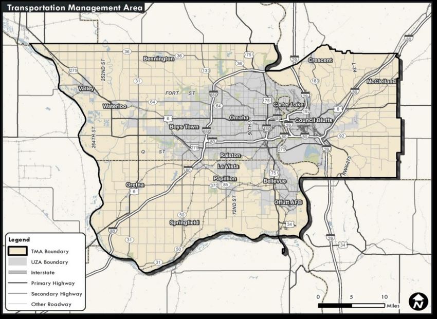
regional in scope and cross jurisdictional boundaries. Figure 1 (next page) illustrates the MAPA TMA.
The governing body for MAPA is a 64-member Council of Officials representing cities, counties, school districts,
resource agencies, and numerous other governmental bodies within the region. The MAPA Board of Directors is a
nine-member Board serving as the Council of Officials’ executive committee and is comprised of elected officials
representing cities and counties from the larger five-county MAPA region. The Transportation Technical Advisory
Committee (TTAC) reviews and makes recommendations related to transportation to the MAPA Board. The
relationship, responsibility, and composition of the Board of Directors, Council of Officials, and TTAC are also
described in the MAPA Interlocal Agreement and Committee Bylaws. Membership of key MAPA Committees
Appendix II
COUNCIL OF GOVERNMENTS
MAPA is governed by a 63-member Council of Officials, representing each
of the 63 governmental units which comprise MAPA within the five counties
it serves. They include: Douglas, Sarpy, and Washington Counties in
Nebraska; Pottawattamie and Mills Counties in Iowa. The Council’s roles
include approving the agency’s long range plan and setting overall policy.
TRANSPORTATION PLANNING AFFILIATIONS
In its role as a Metropolitan Planning Organization, MAPA is the pass-
through agency for millions of dollars in federal transportation funding for
the Transportation Management Area (TMA) it serves which consists of
Douglas and Sarpy Counties in Nebraska and western Pottawattamie
County in Iowa (mainly the boundaries of the City of Council Bluffs). In
addition, MAPA also serves as the administrator for Iowa Regional
Planning Affiliation 18, which includes the counties of Harrison, Mills and
Shelby, and the non-urbanized portion of Pottawattamie County.
MPO = BLUE
RPA-18 = YELLOW
METROPOLITAN STATISTICAL AREA
At the time of its inception in 2011, the work of the Heartland 2050
Regional Visioning project included the eight counties in the Omaha
Metropolitan Statistical Area (MSA). The MSA counties include all five
counties in the MAPA region plus Saunders and Cass Counties in
Nebraska and Harrison County in Iowa. Heartland 2050 has evolved into
the Heartland 2050 Regional Planning Committee and it will focus its core
work on the five counties in the MAPA region.
iFigure 1 – MAPA Transportation Management Area
Several large planning initiatives have been recently completed or are underway in the MAPA region. Heartland
2050 was adopted by the MAPA Council of Officials as the long-term vision for the greater Omaha-Council Bluffs
metropolitan area in January 2015. The Regional Vision was developed over 2013 and 2014 and entered
implementation phase in 2015. The project produced a Vision Scenario for future growth and development that is
now being utilized for MAPA’s transportation planning process.
During FY-2019 MAPA continued work on its next Long Range Transportation Plan update, LRTP 2050. The
LRTP is being closely coordinated with the Metro Area Travel Improvement Study (MTIS), a joint Nebraska
Department of Transportation (NDOT) / MAPA multi-year regional study of highway needs that will result in a list
of prioritized projects for state investment and guide future regional transportation investments. MAPA is working
closely with the Greater Omaha Chamber of Commerce in the development of this new long range vision for
transportation, with a particular emphasis on enhancing the accessibility of jobs and education through our
transportation system. This comprehensive study has developed a strong set of data for MTIS and other planning
projects, and MAPA’s travel demand model has been updated significantly as part of ongoing collaboration with
US-DOT. MTIS will also serve to develop long-range performance targets that will be support the requirements of
MAP-21 and the FAST-ACT, the current transportation authorization bill. Throughout FY2019 MAPA closely
iicoordinated with State DOTs and FHWA on implementing federal performance management guidelines for PM1,
PM2 and PM3. The performance-based approach is a new component of the federal transportation planning
process and is another federal PEA that will be very important during FY2020.
The LRTP 2050 will also incorporate other recent plans that were conducted in the metro are. These include the
Heartland Connections Regional Transit Vision (RTV) and Regional Bicycle-Pedestrian Plan. The RTV
proposed a staged approach to improve transit service in the region. These concepts were applied as part of the
Sarpy County Transit study in FY2018 in addition to Metro Transit’s Transit Development Plan– a key initiative in
both FY2018 and FY2019. These scenarios are being utilized for further analysis in the MTIS study. In FY2020,
MAPA will be revisiting the short, medium, and long-range projects in its Regional Bike-Ped Plan to enhance the
regional network of trails, bicycle boulevards, and other bicycle / pedestrian facilities with a particular emphasis on
the safety of vulnerable users.
Metro Transit is continuing work on the Bus Raid Transit (BRT) line that was awarded a US-DOT discretionary
TIGER grant that will run along the Dodge Street corridor from downtown Omaha to Westroads Mall at
approximately 102nd Street. This premium transit service would serve as the spine of the transit network in the
region. The project will help some of the densest concentrations of employment and housing in Omaha and
exemplify the Ladders of Opportunity PEA. Final Design was completed in FY2019 and will be construction will
commence in 2020.
In FY2020 MAPA will continue to emphasize freight planning as part of the Regional Transportation Planning
Process. The Nebraska Department of Transportation completed its State Freight Plan in 2017 and MAPA will
continue partner with NDOT on the plan’s implementation and continued outreach. In 2018 MAPA identified a
specific need for additional truck count data and is coordinating with NDOT to increase the frequency with which
truck counts are conducted and also target them in areas where gaps current exists in MAPA’s data. MAPA’s
ongoing improvements to the travel demand model will allow additional technical analysis of freight transportation
in the metro area. MAPA’ coordination with the Greater Omaha Chamber of Commerce on its LRTP presents an
unprecedented opportunity to stand up a freight advisory committee to better understand freight bottlenecks in the
region and prioritize goods movement in the planning process.
Some of the City of Omaha major transportation projects include bridge needs, a massive signal infrastructure
upgrade, and several capacity improvements in the western part of Omaha, including multiple projects near West
Dodge Road (US-6) along 168th Street, 180th Street, 192nd Street. Douglas County is preparing to let a large
project on 180th Street between West Dodge Road and West Maple Road in FY2019– culminating years of
coordination and planning between federal state, and local partners.
During FY-2018, communities in Sarpy County created a new intergovernmental authority to manage the growth
of the sanitary sewer system in the county and to rehabilitate sewers in existing communities as well. This
infrastructure will be crucial in guiding future development in Sarpy County and will be a critical factor in future
transportation decisions. MAPA awarded a H2050 mini-grant to Sarpy County to explore the future needs on the
arterial and collector road system based on these proposed growth trends. The Highway 75 project will be under
construction that will connect Bellevue and Plattsmouth with a grade-separated freeway. MAPA successfully
coordinated resources between the Nebraska Department of Transportation, Sarpy County, Cass County,
Bellevue, Plattsmouth, and the Papio-Missouri River NRD (PMRNRD) to ensure that this new corridor did not
preclude bicycle and pedestrian access. Girders for the trail connection on this segment were installed during
FY2018 and MAPA continued to coordinate with make progress towards the construction of the connecting trail.
The Council Bluffs Interstate (CBIS) Project, a complete reconstruction of the interstate and railroad
realignment, is scheduled to continue for at least the next eight years. Council Bluffs continues implementing its
plan for West Broadway corridor that includes the reconstruction of West Broadway and creation of a
multimodal transit corridor along 1st Avenue. A significant mixed-use project is currently under construction at
Playland Park on the east end of the Bob Kerrey Pedestrian Bridge. Transportation in this area continues to be a
key focus as community leaders and the philanthropic community are reimagining the riverfront and seeking to
balance its redevelopment potential and access to open space. Additional progress has been made on the East
Beltway project in Council Bluffs, with the second phase of project let in FY2019.
iiiWork has continued on the development of a Coordinated Call Center and information sharing for the region.
Metro Transit, the Veterans Administration (VA), and MAPA are working together to coordinate the development
and implementation of the Coordinated Call Center including the purchase of hardware, software, and system
engineering. Presently, Metro Transit’s MOBY Paratransit service is coordinated along with the State of
Nebraska’s Medicare & Medicaid Transportation services. MAPA continues to work with other local and non-profit
partners to build on this existing coordination between partners.
MAPA helped implement two Congestion Mitigation Air Quality (CMAQ) projects including the installation of35
new bike share stations in the City of Omaha in FY2019. Progress continues to be made on the installation of up
to 20 electric vehicle charging stations by the City of Omaha.
MAPA will administer and update the region’s FY 2019-2024 Transportation Improvement Program (TIP). The
TIP includes state and local federal-aid projects and regionally significant projects programmed in the region for
the next six years. In addition to roadway projects, the TIP covers anticipated expenditures for some alternative
transportation projects such as the Transportation Alternatives Program (TAP), transit, and aviation. MAPA has
continued to develop online TIP database and mapping platform that provides up-to-date programming
information to project partners and helps track the status of projects in both Iowa and Nebraska.
MAPA’s Coordinated Transit Committee (CTC) works on issues related to public transit, paratransit, and human
services transportation. A FTA Veterans Transportation and Community Living Initiative (VTCLI) grant to
develop a Coordinated Call Center for human services made progress through the first two summits during FY
2015. These resources helped create a core network of Automatic Vehicle Location (AVL) technology to provide
real-time data toe other agencies and serve as the foundation of coordinated services between human service
organizations and transit agencies in the region– including through a new mobile app set to launch in late
FY2019. This effort, in addition to the transit activities listed previously, addresses the Ladders of Opportunity
PEA by improving gaps in the transportation system and mobility for residents. MAPA’s robust public participation
processes are other examples of steps toward the Ladders of Opportunity PEA.
ivMAPA’s Unified Planning Work Program (UPWP) is developed in accordance with the metropolitan planning
provisions described in the 23 CFR - Part 450 and 49 CFR - Part 613. The UPWP is created in cooperation with
state and federal agencies who are financial sponsors, and it is intended as a management tool for participating
agencies.
MAPA has continued to update and maintain its Strategic Plan first developed with the MAPA Board in 2016.
During the development of the UPWP, a priority setting process was used to evaluate existing programs and
projects against these goals. Additional outreach was conducted to the Council of Officials, Board of Directors,
and TTAC to understand our members’ needs for the upcoming year. Results of the priority setting process are
reflected by the projects and associated funding levels shown in the UPWP.
In accord with the spirit of federal transportation legislation, MAPA conducts a continuing, coordinated, and
comprehensive planning process for the region. This process is intended to meet the transportation needs of the
region’s residents to the extent possible with available resources.
The transportation planning process for the region takes into account all modes of transportation: roadway,
highway, transit, air, rail, and water, as well as active modes of transportation such as walking and bicycling. The
provision of transportation services must also be consistent and compatible with the overall goals and
development of the region. Major considerations include the environment, energy conservation, growth patterns,
land use, tourism, and recreation, as well as a wise and efficient use of economic resources.
MAPA’s responsibilities include the LRTP, TIP, and UPWP. As a TMA with a population greater than 200,000,
MAPA is charged with conducting a Congestion Management Process (CMP). Other planning products include
the Coordinated Public Transit and Human Services Plan and Public Participation Plan (PPP). MAPA is compliant
with civil rights legislation and maintains a Title VI Plan and Disadvantaged Business Enterprise (DBE) Program.
The UPWP will also contain activities to assist in implementing provisions contained in surface transportation
legislation. The following planning factors identified in the current federal legislation, Fixing America’s Surface
Transportation (FAST) Act, will, at a minimum, be considered in the transportation planning process for the
region:
1. Support the economic vitality of the metropolitan area, especially by enabling global competitiveness,
productivity, and efficiency.
2. Increase the safety of the transportation system for motorized and nonmotorized users.
3. Increase the security of transportation for motorized and nonmotorized users.
4. Increase the accessibility and mobility options available to people and for freight.
5. Protect and enhance the environment, promote energy conservation, and improve quality of life.
6. Enhance the integration and connectivity of the transportation system across and between modes for
people and freight.
7. Promote efficient system management and operation.
8. Emphasize the preservation of the existing transportation system.
9. Improve resiliency & reliability of the transportation system and reduce or mitigate storm water
impacts.
10. Enhance travel and tourism
vIn addition, the transportation planning program is formulated to support the goals and objectives specific to the
region as identified in the 2040 LRTP, namely:
1. Maximize access and mobility.
2. Increase safety and security.
3. Consider the environment and urban form.
4. Keep costs reasonable and sustainable.
The UPWP budget includes additional matching funds beyond the 20% requirement from sub-recipients used to
match FHWA PL funds for MAPA activities. These locally-funded planning activities contribute to the regional
transportation planning process and are eligible to count toward the required local match for PL funding. In order
to provide this match, sub-recipients of PL funds contribute a 30% match. The 10% of additional match beyond
the 20% requirement provides match toward PL funds for MAPA activities. Sub-recipients for the FY2020 Work
Program are summarized in the table below.
Awardee Federal Source Federal Share Total Project Cost
Douglas County GIS PL-Nebraska $55,000 $78,571
Sarpy County GIS & Planning PL-Nebraska $57,000 $81,429
City of Omaha Planning PL-Nebraska $30,000 $42,857
City of Omaha Public Works PL-Nebraska $60,000 $85,714
Pottawattamie County -GIS PL-Iowa $30,000 $42,857
Metro Transit FTA-5305d $60,000 $85,714
viAll changes to work programs require prior written federal approval, unless waived by the awarding agency. The
following table denotes the approving agency for various changes to work programs.
NOTE: The below table will be updated when final guidance is provided by NDOT and Iowa DOT.
Revision Type Approving Agency
Request for additional federal funding 2 CFR FHWA / FTA
200.308(b)and FTA Circular 5010.0C,I.6.e(1)]
Transfer of funds between categories, projects, functions, or FHWA / FTA
activities which exceed 10 percent of total work program
budget $150,000 2 CFR 200.308(e)
Revision of scope or objectives of activities (i.e. adding or FHWA / FTA
deleting activities or major change in scope of activity) 2 CFR
200.308 (c) (1)
Transferring substantive programmatic work to third party FHWA / FTA
(i.e. consultant) 2 CFR 200.308 (c) (6)
Capital expenditures including equipment purchasing in FHWA / FTA
excess of $5,000 2CFR 200.439(a) (2) [OMB Circular A-87)]
Transfer of funds allotted for training allowances 2 CFR FHWA / FTA
200.308 (c) (5)
Transfer of funds between categories, projects, functions, or State
activities which do not exceed 10 percent of total work
program budget or when federal award share of total work
program budget exceeds $150,000 2 CFR 200.308 (e)
Revisions related to work that does not involve federal MAPA
funding
viiRevisions where FHWA / FTA is the designated approving agency shall require written approval by FHWA / FTA
prior to commencement of activity, purchasing of equipment, or request for reimbursement. Requests from MAPA
will be submitted in writing to the appropriate state personnel and then forwarded to FHWA / FTA for approval.
Notification by the approving agency will be in writing in reverse order.
Revisions where the State (NDOT or Iowa DOT Office of Systems Planning) is the designated approving
agency shall require written approval by the State prior to commencement of activity, purchasing of equipment, or
request for reimbursement. Requests from MAPA will be submitted in writing to the appropriate State personnel
and then forwarded to FHWA / FTA for approval. Notification by the approving agency will be in writing in reverse
order.
Revisions where MAPA is the approving agency shall be approved by the Board of Directors. Updates to the work
program shall be provided to the appropriate state and federal representatives via electronic or, upon request,
hard copy.
Performance management agreement between MAPA and State DOTs
On May 27, 2016, the final rule for statewide and metropolitan transportation planning was published, based on
2012’s Moving Ahead for Progress in the 21st Century (MAP-21) Act and 2015’s Fixing America’s Transportation
System (FAST) Act. As part of this final rule, 23 CFR 450.314 (h) was amended to state:
(h)(1) The MPO(s), State(s), and the providers of public transportation shall jointly agree upon and develop
specific written provisions for cooperatively developing and sharing information related to transportation
performance data, the selection of performance targets, the reporting of performance targets, the reporting of
performance to be used in tracking progress toward attainment of critical outcomes for the region of the MPO (see
§450.306(d)), and the collection of data for the State asset management plan for the NHS for each of the
following circumstances:
(i) When one MPO serves an urbanized area;
(ii) When more than one MPO serves an urbanized area; and
(iii) When an urbanized area that has been designated as a TMA overlaps into an adjacent MPA serving
an urbanized area that is not a TMA.
(2) These provisions shall be documented either:
(i) As part of the metropolitan planning agreements required under paragraphs (a), (e), and (g) of this
section; or
(ii) Documented in some other means outside of the metropolitan planning agreements as determined
cooperatively by the MPO(s), State(s), and providers of public transportation.
In 2017, the following three-pronged approach was cooperatively developed to address 23 CFR 450.314 (h) for
MPOs in Iowa. This approach provides a regular opportunity to review and update coordination methods as
performance management activities occur, which offers an adaptable framework as performance-based planning
and programming evolves.
Agreement between the Iowa DOT and MPOs on applicable provisions through documentation included
in each MPO’s TPWP.
Agreement between the Iowa DOT and relevant public transit agencies on applicable provisions through
documentation included in each public transit agency’s consolidated funding application.
Agreement between each MPO and relevant public transit agencies on applicable provisions through
documentation included in the appropriate cooperative agreement(s) between the MPO and relevant
public transit agencies.
Performance measures require coordination with the MPOs to set performance targets, collect performance
measure data and report performance measure data to FHWA and/or FTA. These requirements are included in
this MPO manual as detailed in this section and identify the responsibilities for carrying out performance-based
planning and programming in the metropolitan planning area (23 CFR 450.314(h)). National goals and
performance management measures are identified in 23 U.S.C §150 and Federal Transit performance measures
for capital assets are identified in 49 CFR §625.43 and safety in 49 CFR Part 673.
viiiThis following section includes the provisions for cooperatively developing and sharing information related to
transportation performance data, selecting performance targets, reporting performance targets, performance used
in tracking progress toward attainment of critical outcomes for the region of the MPO, and collecting data for the
State Transportation Asset Management Plan (TAMP) for the NHS. Inclusion of the following language in an
MPO’s TPWP, and that TPWP’s subsequent approval by Iowa DOT, constitutes agreement on these items. The
Iowa DOT and MAPA agree to the following provisions. The communication outlined in these provisions between
the MPO and Iowa DOT will generally be through the statewide planning coordinator in the Office of Systems
Planning.
1) Transportation performance data
a. The NDOT and Iowa DOT will provide MPOs with the statewide performance data used in
developing statewide targets, and, when applicable, will also provide MPOs with subsets of the
statewide data, based on their planning area boundaries.
b. If MPOs choose to develop their own target for any measure, they will provide the NDOT and
Iowa DOT with any supplemental data they utilize in the target-setting process.
2) Selection of performance targets
a. The NDOT and Iowa DOT will develop draft statewide performance targets for FHWA measures
in coordination with MPOs. Coordination may include in-person meetings, web meetings,
conference calls, and/or email communication. MPOs shall be given an opportunity to provide
comments on statewide targets and methodology before final statewide targets are adopted.
b. If an MPO chooses to adopt their own target for any measure, they will develop draft MPO
performance targets in coordination with the NDOT and Iowa DOT. Coordination methods will be
at the discretion of the MPO, but the NDOT and Iowa DOT shall be provided an opportunity to
provide comments on draft MPO performance targets and methodology prior to final approval.
3) Reporting of performance targets
a. NDOT and Iowa DOT performance targets will be reported to FHWA and FTA, as applicable.
MPOs will be notified when NDOT and Iowa DOT has reported final statewide targets.
b. MPO performance targets will be reported to the NDOT and Iowa DOT.
i. For each target, the MPO will provide the following information no later than 180 days
after the date the NDOT and Iowa DOT or relevant provider of public transportation
establishes performance targets, or the date specified by federal code.
1. A determination of whether the MPO is 1) agreeing to plan and program projects
so that they contribute toward the accomplishment of the NDOT and Iowa DOT
or relevant provider of public transportation performance target, or 2) setting a
quantifiable target for that performance measure for the MPO’s planning area.
2. If a quantifiable target is set for the MPO planning area, the MPO will provide any
supplemental data used in determining any such target.
3. Documentation of the MPO’s target or support of the statewide or relevant public
transportation provider target will be provided in the form of a resolution or
meeting minutes.
c. The NDOT and Iowa DOT will include information outlined in 23 CFR 450.216 (f) in any statewide
transportation plan amended or adopted after May 27, 2018, and information outlined in 23 CFR
450.218 (q) in any statewide transportation improvement program amended or adopted after May
27, 2018.
d. MPOs will include information outlined in 23 CFR 450.324 (g) (3-4) in any metropolitan
transportation plan amended or adopted after May 27, 2018, and information outlined in 23 CFR
450.326 (d) in any transportation improvement program amended or adopted after May 27, 2018.
e. Reporting of targets and performance by the NDOT and Iowa DOT and MPOs shall conform to 23
CFR 490, 49 CFR 625, and 49 CFR 673.
ix4) Reporting of performance to be used in tracking progress toward attainment of critical outcomes
for the region of the MPO
a. The NDOT and Iowa DOT will provide MPOs with the statewide performance data used in
developing statewide targets, and, when applicable, will also provide MPOs with subsets of the
statewide data, based on their planning area boundaries. Updates of this data will include prior
performance data.
5) The collection of data for the State asset management plans for the NHS
a. The NDOT and Iowa DOT will be responsible for collecting bridge and pavement condition data
for the State asset management plan for the NHS.
xFY-2020 WORK PROGRAM ACTIVITIES
The following pages detail the work activities that MAPA and contract sub-recipients will undertake in FY 2019.
Work Program & Federal Assurances (200)
Objective
To efficiently develop and implement MAPA’s Unified Planning Work Program (UPWP) in accordance with MPO
responsibilities and federal requirements
Previous Work
● Maintained and updated UPWP
● Developed & Executed PL Agreements with NDOT
● Certification Review in July of 2018 and implementation of Action plan
● Executed and administered contracts with sub-recipients
● Quarterly reporting & Invoicing to NDOT & IDOT
● Update to Title VI, Limited English Proficiency and ADA policies
● Developed Annual DBE Goal
Work Activities
1. Planning Agreements
Maintain and review the Memorandum of Agreement (MOA) outlining state, MPO, and transit responsibilities.
Develop and execute the annual PL Agreements with Nebraska and Iowa.
2. Unified Planning Work Program (UPWP)
Develop FY2021 UPWP and maintain the FY2020 UPWP. A draft UPWP is approved in March by the
Council of Officials, Board of Directors, and TTAC, with submittal in April for state and federal review. Final
approval by MAPA occurs in May, with submittal in June to state and federal agencies.
3. Certification Review Action Plan
Implement the federal Certification Review Action Plan for MAPA’s programs. Review progress and revise
activities on an ongoing basis.
4. Civil Rights & Disadvantaged Business Enterprise (DBE)
The approved Title VI Plan will be modified and updated as needed. Communicate civil rights activities to
FHWA/FTA. Review DBE Program and develop annual goals. Participate in regional equity forums to ensure
transportation is incorporated into broader planning and equity initiatives.
200 End Products Schedule
1. Planning Agreements Ongoing
2. Unified Planning Work Program (UPWP) Ongoing
3. Certification Review Action Plan Ongoing
4. Civil Rights & Disadvantaged Business Enterprise (DBE) Quarterly
200 Budget Federal Cost Total Cost Hours
MAPA Activities $22,459 $24,643 380
1Board & Committee Support (210)
Objective
To support ongoing activities of MAPA’s Council of Officials, Board of Directors, Finance Committee,
Transportation Technical Advisory Committee (TTAC) and Regional Planning Advisory Committee (RPAC)
Previous work
● Organized monthly Board of Directors meetings
● Participated in monthly Finance Committee meetings
● Conducted four Council of Officials meetings, including annual meeting / dinner
● Prepared and conducted monthly TTAC meetings
Work Activities
1. Council of Officials
The Council of Officials meets quarterly and serves as MAPA’s overall policy body. The Council is charged
with adopting major plans, recommending MAPA’s annual budget and work programs to the Board of
Directors, and providing oversight for MAPA’s activities. MAPA staff members support the Council’s activities
through clerical and technical preparation, meeting costs, and conducting meetings.
2. Board of Directors
The Board of Directors meets monthly and serves as MAPA’s governing body. The Board approves the TIP
amendments, LRTP, annual budget, and work programs. The Board is comprised of elected officials who
appoint and oversee the TTAC and other MAPA committees. MAPA staff members support the Board
through clerical and technical preparation, conducting meetings, and informing members about MAPA
activities.
3. Finance Committee
The Finance Committee meets each month during the week prior to the Board of Directors’ meeting. The
Finance Committee reviews MAPA’s financial statements, approves payments, and reviews / recommends
contracts, large payments and other items for the Board’s consideration. MAPA staff members support the
Finance Committee through preparation of financial documents, invoices, contracts, and other such items.
4. Transportation Technical Advisory Committee (TTAC)
Provide for a continuing, comprehensive, and coordinated transportation planning program through the
TTAC. Maintain correspondence and coordination with participating agencies. Provide other technical
support necessary to the transportation planning program. The TTAC meets on a monthly basis to approve
action items and discuss issues within the region to forward recommendations to the Board of Directors.
5. Regional Planning Advisory Committee (RPAC)
Provide a forum to coordinate future planning and growth in the Greater Omaha-Council Bluffs region. The
Committee will provide direction for the regional vision (Heartland 2050) through oversight of the
Implementation Committees work and strategic decision-making. The RPAC meets on a bi-monthly basis to
approve action items and discuss issues within the region to forward recommendations to the Board of
Directors.
2210 End Products Schedule
1. Council of Officials Quarterly
2. Board of Directors Monthly
3. Finance Committee Monthly
4. Transportation Technical Advisory Committee (TTAC) Monthly
5. Regional Planning Advisory Committee (RPAC) Bi-Monthly
210 Budget Federal Cost Total Cost Hours
MAPA Activities $145,206 $159,530 2,454
Regional Transportation Planning (220)
Objective
To conduct the transportation planning activities related to the development and implementation of the Long
Range Transportation Plan
Previous Work
● Continued development of 2050 LRTP materials for the unified transportation plan
● Developed revised regional narrative for LRTP and CEDS documents
● Completed Phase 3 of the Metro Travel Improvement Study for the region
● Served on action team for City of Omaha Transit Oriented Development (TOD) policy
● Participated in development of Complete Streets Design Manual for City of Omaha
● Participated in stakeholder committees for Omaha Rapid Bus Transit (ORBT) project
● Conducted outreach to freight and private sector representatives
● Assisted with local planning studies, including providing forecasts and data
MAPA Work Activities
1. LRTP Development and Administration
Develop 2050 LRTP to be adopted by October 2020. Implement, review, and amend the LRTP as
necessary. Support regional goals in accordance with the federal transportation planning provisions. As a
key element of the LRTP development efforts performance measures will be developed and assessed as
part of the scenario planning for the 2050 LRTP. Coordination with Greater Omaha Chamber of Commerce
(GOCC) Prosper 2.0 and Comprehensive Economic Development Strategy (CEDS) update. Utilize
consultants for various portions of the LRTP including marketing and public involvement activities such as
the development of brochures, websites, info-graphics, surveys, and citizen engagement events. Purchase
interactive tools for engaging the public.
2. Transit Planning Activities
Provide data, technical analysis, and coordination in support of short-range and long-range mass transit
planning. This will include collaboration with Metro Transit, MAPA committees, local governments, nonprofit
agencies, and other stakeholders in the transit planning process. Continue the implementation of the
Regional Transit Vision through the Transit Development Plan and Close the Gap strategy proposed in
Heartland 2050. Included in this is continued planning support for the Omaha Bus Rapid Transit (ORBT)
corridor, potential future BRT extensions, core system improvements, suburban and express route
enhancements. Study continues on a proposed modern streetcar concept in downtown and midtown Omaha.
Ongoing support of transit planning in Council Bluffs and coordination between SWITA and Metro Transit.
3MAPA will also continue to work with transportation service providers, human service agencies, and
stakeholders to encourage, coordinate, and implement plans, actions, and programs to enhance the
transportation opportunities of the elderly, disabled, and economically disadvantaged. The Coordinated
Transit Plan, adopted in FY2018, will continue to be implemented through the Coordinated Transit
Committee and its work groups.
3. Bicycle & Pedestrian Planning Activities
Participate in bicycle / pedestrian planning activities for the region, including the implementation of the
Omaha Complete Streets policy and development of the Complete Streets Design Guide. Support
implementation of the Complete Streets policy included in the LRTP. Assist with implementation and updates
to the Heartland Connections Regional Bicycle / Pedestrian Plan with local project partners. Support the
Mayor of Omaha’s Active Living Advisory Committee, including as a representative on the Vision Zero Task
Force. Support local advocacy for bicycle and pedestrian investment.
4. Freight Planning & Coordination
Convene representatives from freight and goods movement industries as well as local, state and federal
officials to ensure that freight is included in the regional planning process. Much of this work will be
conducted as part of the Unified Regional Transportation Plan being coordinated by the Greater Omaha
Chamber. Analyze potential solutions to issues developed through the stakeholder outreach. Support
private sector participation in the transportation planning process by working with local Chambers of
Commerce, Economic Development Corporations, freight representatives, and private transportation
industries to review transportation plans / programs. Utilize the Freight Analysis Framework (FAF) and other
publicly available data. Purchase data to conduct planning studies, analyses, and modeling of freight and
goods movement in the region.
5. Congestion Management Process (CMP)
Implement recommendations to enhance the CMP contained in the Certification Review report. Monitor
causes of recurring / nonrecurring congestion and identify congestion relief opportunities. Utilize data
collected from MTIS, NDOT, Iowa DOT, and other sources to assess existing congestion conditions in the
region. Update CMP and approve as a stand-alone document in coordination with 2018 Traffic Reports.
Prepare and conduct sessions on congestion for the Transportation Summit, and potentially hold additional
working group sessions.
6. Other Long-Range Studies
Provide technical assistance and related transportation system travel, financial, and socioeconomic data to
the states and local jurisdictions as requested to assist in conducting long-range corridor, location, subarea,
feasibility, and other project level studies. This element includes working on PEL and IJR activities for a new
I-80 Interchange in the 180th-192nd Street area of Sarpy County, as well as other projects requiring
coordination with cities, counties, states, utilities, and other stakeholders.
MAPA and NDOT will continue work on MTIS, a comprehensive study of the National Highway System and
other modes of transportation in the region. Phase 3 reports will be incorporated into the LRTP 2050 with
construction phasing being coordinated between state and local projects.
220 End Products for MAPA Work Activities Schedule
1. LRTP Development and Administration (2050 LRTP) Ongoing
2. Transit Planning Activities Ongoing
3. Bicycle & Pedestrian Planning Activities Ongoing
4. Freight Planning & Coordination Ongoing
5. Congestion Management Process (CMP) Ongoing
6. Other Long-Range Studies Ongoing (MTIS (Q1)
4220 Budget Federal Cost Total Cost Hours
MAPA Activities $187,482 $205,987 3,169
Contracts and Sub-recipients Federal Share (Total Cost)
Transportation Support & Communications (22001) $60,000 ($75,000 total)
MAPA will utilize our on-call communications firm to provide support for regional visioning and transportation
planning efforts, including coordination with the Unified Transportation Plan, Smart Cities and Heartland 2050.
These deliverables may include items such as brochures, website content, videos, local transportation needs and
funding analysis, and strategic communications activities.
Regional Bicycle-Pedestrian Plan Update (22002) $60,000 ($75,000 total)
MAPA will procure a consultant to assist with updates to the 2015 Heartland Connections Regional Bicycle-
Pedestrian Plan. Updates will include review of implemented projects, updates to corridors, and identification of
denser bicycle networks in regionally significant nodes throughout the region.
Transportation Improvement Program (TIP) & Local Projects (230)
Objectives
To monitor and maintain a fiscally constrained Transportation Improvement Program for regionally significant
transportation projects.
To implement performance-based planning requirements of the FAST Act.
To ensure MAPA staff representation and coordination with local partner projects.
To ensure the successful administration of the Metro Area Motorist Assist (MAMA) Program
Previous Work
● Processed TIP Amendments and Administrative Modifications
● Continued development of online TIP database and project management platform
● Completed development of FY2020 TIP
● Assisted with the implementation of the CMAQ-funded bike share expansion project
● Administered Project Selection Subcommittee (ProSe-Com) for Surface Transportation Program (STBG)
● Administered the Transportation Alternatives Program Committee (TAP-C) for Transportation Alternatives
Program (TAP) projects
● Administered the Coordinated Transit Committee for transit projects related to Section 5310 and JARC
funding
● Provided transportation technical assistance to member cities and counties
MAPA Work Activities
1. Maintenance of FY2018 and FY2019 Transportation Improvement Programs (TIPs)
Administer the FY2019TIP (through September 30th, 2019) and FY2020 TIP (beginning October 1st, 2019).
Process Amendments and Administrative Modifications of the trip as necessary. Monitor and maintain fiscal
constraint of the TIP and ensure consistency of the TIP with the LRTP.
2. Project Selection Activities (STBG, TAP, & 5310)
The Project Selection Committee (ProSeCom) will be convened to review and recommend federal-aid
projects eligible for STBG funds based on project selection criteria linking the TIP to the LRTP’s goals. The
Transportation Alternatives Program Committee (TAP-C) will be convened to review and recommend
federal-aid projects eligible for TAP funds based on project selection criteria linking the TIP to regional
bicycle / pedestrian goals. The Coordinated Transit Committee (CTC) will be convened to review and
recommend funding for Section 5310 based on project selection criteria linking the TIP, Coordinated Transit
Plan and the Long Range Transportation Plan.
53. Transportation Funding Analysis
Identify funds available to the region from federal and state transportation legislation. Identify and assess
innovative financing techniques to fund projects and programs. Provide data and information to officials on
the status of transportation funding in the MPO. Analyze the costs / benefits of short-range and long-range
needs in conjunction with local / state partners in collaboration with the LRTP. Coordination with State and
Federal officials on transportation funding issues. Analyze and implement TIP Administrative Fee for federal-
aid projects.
4. Development of FY2021 Transportation Improvement Program
Develop the TIP to provide a program of federal-aid transportation projects. The TIP includes at least four
fiscally-constrained years of programming and a prioritized project list with a financial plan for project
implementation. A progress report on the implementation of projects programmed for the most recent fiscal
year will be also be included. The updated TIP is approved each year in June and is ready for
implementation when the new federal fiscal year begins on October 1st. In addition, as performance
measure final rulings per FAST Act are issued these will be included based on state and federal guidance.
5. Performance Measurement & Reporting
MAPA will coordinate with state and federal agencies to develop a set of performance measurements for the
LRTP and TIP. Conduct studies and analyses of transportation data to develop and assess performance
measures. Performance measures will be developed as part of the MTIS and LRTP plans. Data will be
purchased (as necessary) to support the performance measurement analyses and implementation. New
annual targets for Safety performance measures will be adopted before February 27, 2020.
6. Local Project Support & Coordination
MAPA staff members provide technical assistance for MAPA, local and state transportation projects as
needed. In particular, MAPA’s local project liaison will work to coordinate project delivery with MAPA
planning and administration, and assist with project communication and streamlining. MAPA may serve as
the Responsible Charge (RC) for Nebraska projects using federal funds. Attend Nebraska Environmental
Assessment (EA) meetings to track the progress of local projects through the NEPA process. Assist
jurisdictions with grant writing and administration for transportation activities on projects including the
USDOT, Iowa DOT, and other grant opportunities. Continue participation in regional Transportation Systems
Management (TSM) and Transportation Incident Management (TIM) meetings. Attend planning-related
meetings and activities supporting the regional transportation planning process.
230 End Products for MAPA Work Activities Schedule
1. Maintenance of FY2019 & FY2020 TIPs Ongoing
2. Project Selection Activities Winter 2019
3. Transportation Funding Analysis Ongoing
4. Development of FY2021 TIP Spring 2020
5. Performance Measurement & Reporting Ongoing
6. Local Project Support & Coordination Ongoing
230 Budget Federal Cost Total Cost Hours
MAPA Activities $125,923 $138,340 2128
230 Contracts & Subrecipient Work Activities Federal Share (Total Cost)
Sarpy Interchange PEL Study $100,000 federal ($125,000 total)
Planning and Environmental Linkages (PEL) study to determine the location of a new 1-80 interchange in Sarpy
County. Study builds off analysis that was conducted as part of the Metro Travel Improvement Study (MTIS) and
will support an anticipated Interchange Justification Report (IJR). Funding represents regional support of project.
6Eppley Connector Study (23000) $100,000 ($125,000 total)
This planning study will evaluate alternatives for the future connection of a new Missouri River bridge connection
between I-680 and the Storz expressway and associated economic development activities.
Communication & Public Involvement (240)
Objectives
To provide ongoing opportunities for stakeholders & the public to participate in the transportation planning
process
To communicate important information and key decisions about the transportation planning process to the public
To conduct and support events, seminars and other activities that support the transportation planning process
Previous Work
● Drafted and completed update to the Public Participation Plan
● Prepared 2017 annual PPP report
● Performed ADA assessments of venues for public involvement
● Conducted outreach and engagement activities with underrepresented population
● Presented to and facilitated discussion at Citizen’s Academy
● Published newsletters, annual reports, and regional directory
MAPA Work Activities
1. Public Participation Plan (PPP) & Public Engagement Activities
Implement the policies identified in the Public Participation Plan. This plan includes a proactive outreach
program that provides complete information, timely public notice, full public access to key decisions,
opportunities for visioning on the transportation system and land use patterns, and supports an early and
continuing involvement of the public in developing the LRTP and TIP. An annual report documenting public
participation activities conducted during the past year will be created. Conduct public involvement and
engagement efforts related to the transportation planning process. Host public forums and panel discussions
on topics related to and impacted by transportation planning. Conduct presentations and meetings with
service clubs, neighborhoods, community leaders, elected officials, and others to foster strong relationships
and engage the public in the planning process. Efforts will include outreach and engagement activities with
low-income, minority, and other underrepresented segments of the population.
2. Equity & Engagement Committee
Administer and facilitate activities of the Equity and Engagement Committee. Provide input into and
leadership of MAPA’s public participation process. Develop regional tool-kits and scorecards to ensure
representative participation in the planning process. Participate in IAP2 workshops hosted by regional
partners.
3. Publications & Newsletters
Develop, produce, and disseminate the MAPA Annual Report. Prepare and disseminate the Community
Assistance Report. Develop, produce, and disseminate at least six issues of the "What’s Happening for
Community Leaders" newsletter. Develop and maintain a website with a map-based listing of the elected and
appointed public officials for the region Develop and distribute information from local / regional data and
research. The information will include MAPA reports and summaries related to demographics, employment,
land use, housing, traffic, transit, and other programs.
4. Online Activities (Websites & Social Media)
Maintain the MAPA websites including MAPA, Heartland 2050, Little Steps - Big Impact, and Metro
Rideshare. Update the MAPA website with projects, regional data, maps, and committee information. Update
MAPA’s social media to communicate pertinent information to the public. Integrate the MAPA public outreach
efforts with various social media outlets.
75. Participation in Partner Forums
Participation in Federal, State and Local forums to support the transportation planning process. Examples
include public events or hearings related to transportation projects, state commission meetings, and ongoing
coordination meetings between state partners (NDOT and IDOT) and MPOs. Coordination with other local,
transportation-related activities.
240 End Products Schedule
1. PPP & Public Engagement Activities Ongoing
2. Equity & Engagement Committee Quarterly
3. Publications & Newsletters Ongoing
4. Online Activities (Websites & Social Media) Ongoing
5. Participation in Partner Forums Ongoing
240 Budget Federal Cost Total Cost Hours
MAPA Activities $173,034 $190,110 2,925
Regional Data, Mapping, & Modeling (250)
Objectives
To conduct socioeconomic and demographic forecasts in support of the transportation planning process
To develop and maintain regional Geographic Information Systems (GIS)
To develop and maintain modeling tools to support decision-making at the state, regional, and local level
Previous Work
● Developed GIS data in coordination with regional partners
● Coordinated with vendor for 2017 NIROC project
● Completed 2016 traffic & safety reports
● Refined socioeconomic data and scenarios for travel demand model
● Assisted with corrections to annual Census population estimates
● Developed regional permit database
MAPA Work Activities
1. GIS & Regional Transportation Data
Maintain and update an integrated geographic data base system and develop other computerized tools to
assist in the analysis and manipulation of data. Create maps, graphs, and analyses as requested for
jurisdictions and the general public. Coordinate GIS activities in the region to support the planning process.
Work on a portal for traffic count data. Purchase new hardware and accompanying software to support GIS
activities as needed. Collect, purchase, and monitor local travel data including detailed data regarding traffic
counts (such as time of day, occupancy, and vehicle classification), speed, and delay as available from local
jurisdictions and other secondary sources. Develop data for Traffic Growth Reports and continue
development of online resources including the Traffic Data Portal. Review pavement, traffic counts, and other
roadway characteristics for NDOT Highway Performance Monitoring System (HPMS) report.
82. Technical Reports & Forecasts
Utilize the US Census data and other data to provide assistance to jurisdictions, businesses, individuals, and
organizations with projects involving Census data. Purchase necessary data and conduct regional or local
studies for growth monitoring and analysis. Collaborate with data partners toward the development of a
regional data hub. Maintain a land use file based on the monitoring of land use changes through secondary
sources. Keep an employment file detailing employers in the region, number of employees, industrial
classifications, and locations. Maintain files on construction permits, apartment complexes,
subdivisions/SIDs, and housing sales to further define housing locations and characteristics. Support
development of 2018Traffic Growth, Interchange, and Intersection Reports. Monitor other local population
characteristics such as auto ownership, vital statistics, and school enrollment.
3. Regional Growth Monitoring
Tracking of progress towards Heartland 2050 land use vision. Continued development of regional permit
dataset to track ongoing development activities and monitor growth. Development of annual growth report
documenting regional development patterns, land consumption, and permit activity. Develop reports and
visualization tools to illustrate the impact of development patterns on infrastructure costs.
4. Travel Demand Modeling Activities
Maintain and refine the regional travel demand model to provide forecasts for studies and planning activities.
Update the model based on TMIP model peer review and subsequent guidance. Implement ISMS framework
in coordination with Iowa DOT> Conduct regional / subregional travel demand model runs. Analyze output to
provide data for local / state planning. Special modeling activities may be conducted for key corridors such
as Highway 370 and 144th Street. Participate in training activities for travel demand modeling. Purchase
data, software, and licenses for travel demand modeling. Utilize the External Travel Survey data regarding
external traffic patterns and characteristics, as well as the 2009 National Household Travel Survey (NHTS)
data for the region.:
5. Land Use Activity Allocation Model (LUAAM)
Revise forecasts for basic trip generating variables (such as population, households, income, automobile
ownership, and employment) to be utilized in the Land Use Activity Allocation Model (LUAAM) and travel
demand modeling activities. Forecasts are coordinated with local / state partners including the state data
centers. Purchase socioeconomic data for forecasting and modeling activities. Refine the LUAAM to provide
population and employment forecasts for the region. The Envision Tomorrow model from Heartland 2050
may be utilized to conduct subregional workshops and plans. Provide training for stakeholders on the use of
Envision Tomorrow.
250 End Products for MAPA Work Activities Schedule
1. Regional Data & GIS Ongoing
2. Technical Reports & Forecasts As Needed
3. Regional Growth Monitoring Ongoing
4. Travel Demand Modeling Activities Ongoing
5. Land Use Activity Allocation Model (LUAAM) Ongoing
250 Budget Federal Cost Total Cost Hours
MAPA Activities $219,431 $241,093 3,709
250 Contracts & Subrecipient Work Activities Federal Share (Total Cost)
On-Call Modeling Assistance (25003) $35,000 ($35,000 total)
Consultants will provide travel demand model forecasts as requested by MAPA. The model will be updated and
refined following recommendations from the FHWA Resource Center and TMAC input. Validate and provide
9You can also read