Opportunities and Constraints Assessment: Torquay North East Future Residential Investigation Area
←
→
Page content transcription
If your browser does not render page correctly, please read the page content below
Final Report

Opportunities and Constraints Assessment: Torquay
North East Future Residential Investigation Area

Prepared for

DELWP
September 2020

Ecology and Heritage Partners Pty Ltd

   MELBOURNE: 292 Mt Alexander Road, Ascot Vale VIC 3032 GEELONG: 230 Latrobe Terrace, Geelong West VIC 3218
       BRISBANE: Level 22, 127 Creek Street, Brisbane QLD 4000 ADELAIDE: 78 Edmund Avenue, Unley SA 5061
       CANBERRA: 19-23 Moore Street, Turner ACT 2612 SYDNEY: Level 5, 616 Harris Street, Ultimo NSW 2007
                                     www.ehpartners.com.au | 1300 839 325
Contents

1     INTRODUCTION ................................ ................................ ............................ 4
2     METHODS ................................ ................................ ................................ .... 8
3     RESULTS ................................ ................................ ................................ .... 12
4     KNOWN AND LIKELY I MPACTS ................................ ................................ ....... 21
5     STORMWATER MANAGEMENT TECHNIQUES ................................ ..................... 23
6     ENHANCING BIODIVERSITY ................................ ................................ ........... 24
7     LEGISLATIVE AND POLICY IMPLICATIONS ................................ ........................ 26
8     SUITABILITY OF LAND FOR DEVELOPMENT ................................ ...................... 30
9     CONCLUSIONS AND FURTHER REQUIREMENTS ................................ ................. 31
REFERENCES ................................ ................................ ................................ .... 34
FIGURES ................................ ................................ ................................ .......... 37
APPENDICES ................................ ................................ ................................ .... 45

Document Control

         Assessment    Opportunities and Constraints Assessment
            Address    Torquay North East Future Residential Investigation Area
     Project number    14007
    Project manager    Elyse Harrison (Botanist)
                       Andrew Hill (Director / Principal Ecologist), Shannon LeBel (Senior Ecologist / Geelong Resource
     Report reviewer
                       Manager)
           Mapping     Monique Elsley (GIS Coordinator)
           File name   14007_EHP_EA_TorquayNEInvestigationArea_Finalv2_10092020
              Client   DELWP
           Bioregion   Otway Plain
               CMA     Corangamite
             Council   Surf Coast Shire

    Report versions                         Comments                              Comments made by:        Date submitted

 Draft                 Report sent to client for review.                                 EH                  24/07/2020
 Preliminary Final     Report updated based on comments from DELWP.                      EH                  11/08/2020
                       Report updated based on comments from DELWP,                                          28/08/2020
 Final                 Parks Victoria, Corangamite CMA and Surf Coast                    EH
                       Shire Council.
                       Report updated based on additional comments                                           10/09/2020
 Finalv2                                                                                 EH
                       provided by DELWP.

                       Opportunities and Constraints Assessment: Torquay North East Investigation Area                      2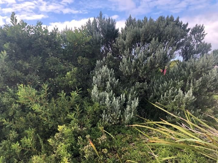
Copyright © Ecology and Heritage Partners Pty Ltd
This document is subject to copyright and may only be used for the purposes for which it was
commissioned. The use or copying of this document in whole or part without the permission of Ecology
and Heritage Partners Pty Ltd is an infringement of copyright.

                                                 Disclaimer
Although Ecology and Heritage Partners Pty Ltd have taken all the necessary steps to ensure that an
accurate document has been prepared, the company accepts no liability for any damages or loss incurred
as a result of reliance placed upon the report and its contents.

              Opportunities and Constraints Assessment: Torquay North East Investigation Area            3
1       INTRODUCTION

Ecology and Heritage Partners Pty Ltd was engaged by the Department of the Environment, Land, Water and
Planning (DELWP) to undertake an opportunities and constraints assessment for the Torquay North East
Future Residential Investigation Area.

1.1     Background
In 2018, the Planning and Environment Act 1987 (the Act) was amended to recognise and safeguard the state’s
Distinctive Areas and Landscapes (DAL) and to achieve better coordinated decision-making by government
agencies, local councils and other key parties. The amendment enables the government to declare an area as
a DAL subject to meeting strict criteria.

The Surf Coast, including land within Surf Coast Shire and City of Greater Geelong, was declared a DAL under
Part 3AAB of the Act on 19 September 2019.

Once declared, a Statement of Planning Policy (SPP) must be prepared for the area in consultation with
responsible public entities, Traditional Owners, the local community, and any other person or entity that may
be affected in preparing an SPP.

An SPP includes a long-term vision of at least 50 years, policy objectives and strategies to achieve the vision,
and a strategic framework plan for guiding the future use and development of land in the declared areas. This
plan may identify long-term settlement boundaries to ensure that development does not inappropriately
encroach into valued natural and rural landscapes.

The current assessment, an ecological opportunities and constraints assessment of the Torquay North East
Future Residential Investigation Area, will help to inform this work.

DELWP is leading the preparation of the draft SPP in collaboration with the Surf Coast Shire Council, the City
of Greater Geelong, the Traditional Owners, the Wadawurrung, and government agencies. The work is
supported by an extensive public engagement program, including gaining inputs by responsible public entities
(RPEs). The Minister for Planning must seek the endorsement of the SPP by RPEs and the Ministers responsible
for those RPEs prior to seeking government approval of it.

1.2     Project Scope and Objectives
It is understood that DELWP requires an ecological assessment of the Torquay North East Future Residential
Investigation Area to be undertaken to determine the possible opportunities and constraints in relation to the
suitability of the land for future development.

As such, the purpose of the ecological assessment was to identify and assess the potential ecological values
and constraints for the Torquay North East Future Residential Investigation Area, including consideration of
the surrounding ecological context. Based on this assessment, recommendations have been provided
regarding the potential suitability of the land for development and any requirements needed to mitigate
impacts on ecological values, including stormwater management.

The ecological assessment will provide DELWP with an understanding of the ecological values present within
the boundaries of the Torquay North East Future Residential Investigation Area, as well as nearby areas of

                     Opportunities and Constraints Assessment: Torquay North East Investigation Area         4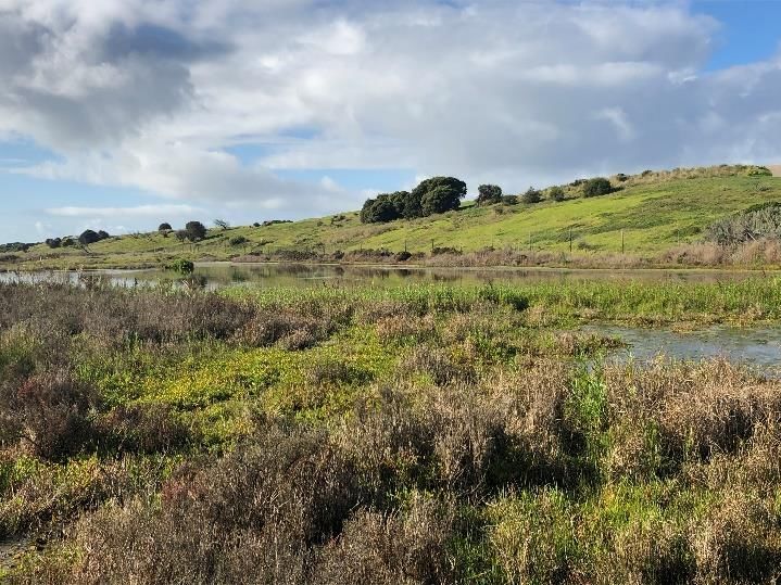
ecological significance, and will inform the preparation of a draft Statement of Planning Policy (SPP) for the
Surf Coast Distinctive Area and Landscape (DAL) project.

Specifically, the objectives of the ecological assessment are as follows:

    •   To identify, assess, and map native flora, fauna, and habitat in the precinct area (including nearby
        wetlands and reserves), including a determination of conservation significance;
    •   To identify ecological opportunities and constraints to inform the preparation of the SPP for the Surf
        Coast DAL project;
    •   To collect and present information about environmental values to allow integration with the planning
        and potential future development of the area (where considered feasible); and,
    •   To provide recommendations and conclusions related to the suitability of the Torquay North East
        Future Residential Investigation Area for development as well as the impacts the potential future
        development will have on nearby reserves.
This report presents the results of the assessment, potential legislative and policy implications, and
summarises future investigations that are likely to be required to inform any future planning approvals
process.

1.3     Study Area

1.3.1 Torquay North East Future Residential Investigation Area
The Torquay North East Future Residential Investigation Area is identified in the Surf Coast Shire’s Sustainable
Futures Plan Torquay – Jan Juc 2040 (June 2014) as an area with a potential future residential capacity of
approximately 760 dwellings.

The Torquay North East Future Residential Investigation Area (herein referred to as the Investigation Area) is
located along Horseshoe Bend Road, approximately 20 kilometres south of the Geelong CBD (Figure 2a). The
site covers approximately 60 hectares and is bound by Horseshoe Bend Road to the west, agricultural/farmland
to the north and east, and residential developments to the south.

The vast majority of the Investigation Area is used for extensive agriculture (crop farming). One main dwelling
presently exists on the site, which is located near the access point along Horseshoe Bend Road. Two man-
made waterbodies (one large and one small) are visible within the investigation area.

The important environmental features of the nearby wetlands (Breamlea Flora and Fauna Reserve and
associated Karaaf Wetlands) need to be recognised in any future development of the area. The Sands,
formerly known as the Golden Beach Resort, is located to the immediate east of Torquay, between Breamlea
and Barwon Heads, and is discussed at 1.3.3, as a nearby site of ecological value.

The Investigation Area is zoned as Farming Zone (FZ). According to the Victorian Department of Environment,
Land, Water and Planning (DELWP2020a) NatureKit Map, the Investigation Area occurs within the Otway Plain
bioregion. It is located within the jurisdiction of the Corangamite Catchment Management Authority, and the
Surf Coast Shire municipality.

1.3.2 Breamlea Flora and Fauna Reserve and Karaaf Wetlands
The Breamlea Flora and Fauna Reserve is a large, open reserve dominated by Coastal Saltmarsh (EVC 9)
(bioregional conservation status of endangered) and includes the adjacent Karaaf Wetlands (Breamlea

                     Opportunities and Constraints Assessment: Torquay North East Investigation Area         5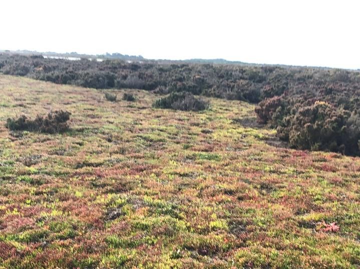
Association 2020). The purpose of the Breamlea Flora and Fauna Reserve is for the preservation of native plant
species. It is approximately 130 hectares in size and is located approximately one (1) kilometre to the east of
the Torquay North East Future Residential Investigation Area (Figure 2; Figure 2b). Thompson Creek also flows
through the saltmarsh in the Breamlea and Karaaf Wetlands to the sea.

The Reserve comprises a large open dune system that is vegetated with coastal grassland and shrubland
vegetation, providing habitat for many bird species, including the threatened Hooded Plover Thinornis
rubricollis. Permanent saline wetlands (the Karaaf Wetlands) are also present within the reserve. Beaded
Glasswort Sarcocornia quinqueflora is one of the major plants in this saltmarsh environment, which plays an
important role as feeding habitat for the nationally significant Orange-bellied Parrot Neophema chrysogaster
(Corangamite CMA 2019).

However, development and land use change continue to either permanently remove this habitat, or render it
unsuitable through off-site impacts such inappropriate hydrological regimes (DELWP 2016). New housing
developments and agricultural intensification are considered the leading current causes of this detrimental
land-use change (DELWP 2016). Changes to the volume and timing of freshwater inflows into saline
environments, through increased stormwater drainage catchments, have the potential to change the floristic
composition of saltmarshes (DELWP 2016), as is presently being experienced within the Breamlea Flora and
Fauna Reserve.

The Breamlea Flora and Fauna Reserve is also an area of cultural heritage sensitivity, and is an area known to
contain, or is likely to contain Aboriginal cultural heritage places and objects. The coastal areas along the
shorelines of the Reserve would have provided important resources for Aboriginal people, including fish and
shellfish, particularly given the shelter offered by the high cliff faces along the coast (DEDJTR, 2019). It is also
understood that the reserve is believed to be where the escaped convict, William Buckley, camped and lived
with the Wathaurang people (Culture Victoria 2020). As such the Breamlea Flora and Fauna Reserve is an area
of both ecological and cultural significance.

1.3.3 The Sands
The Sands, formerly known as the Golden Beach Resort, is located to the immediate east of Torquay, between
Breamlea and Barwon Heads. The site is approximately 124 hectares and consists of a Residential Lakes and
Golf Course Development (Ecology Australia 2001). It is located east of Horseshoe Bend Road and abuts the
southern boundary of the Torquay North East Future Residential Investigation Area (Figure 2; Figure 2c).

Whilst not assessed as part of this current Flora and Fauna Assessment, it is important to understand the past
and present ecological impacts resulting from the Sands development, as the site is immediately adjacent to
the Torquay North East Future Residential Investigation Area.

The key points to note in regard to the Sands development are:

    •   Historical land disturbance and vegetation clearing; and,

    •   The efficiency of the onsite stormwater storage mechanism.

It is understood that, just prior to development, in 1998 several acres of Moonah Woodland and associated
wetlands were removed by excavation work carried out on the proposed resort’s boundary, allegedly without
a planning permit. The type of works was mechanical, whereby most of the vegetation was pushed over at
ground level (Trengrove 1998). The report prepared by Mark Trengrove (1998) which detailed the extent of

                      Opportunities and Constraints Assessment: Torquay North East Investigation Area            6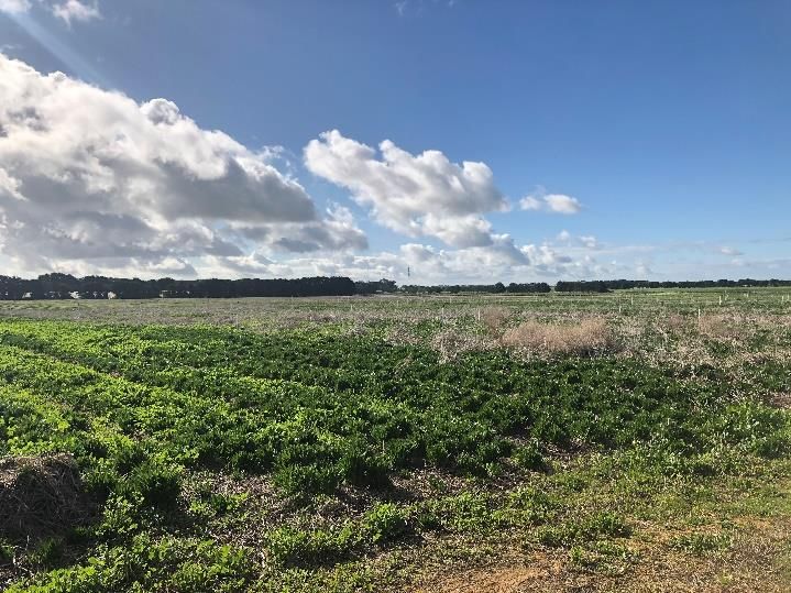
damage caused by the clearing works, stated that approximately 10 hectares of native vegetation was cleared,
the majority of which was Shrubby Glasswort dominated Wet Saltmarsh vegetation.
It was also stated that the impact of clearing had a definite impact upon the conservation values of the site.
They could be described as – physical loss of vascular plants, an unquantified loss of non-vascular plants, loss
of diversity of habitat, fragmentation of habitat, possible impact upon hydrological and ecological processes,
weed invasions and localized erosion (Trengrove 1998).

However, it is understood that the Surf Coast Shire Council requested the requirement for remediation works,
which were subsequently undertaken by the developers.

The Sands development also has a cascade of amenity lakes through the resort, generally aligned east-west
along the drainage line. The purpose of the lakes was to provide a focus for the resort village and residential
areas, as well as playing integral roles in the harnessing of surface water for re-use as golf course irrigation
water (Neil M. Craig Pty Ltd 2001).

The report for the Torquay Sands Development Surface Water Management System (Neil M. Craig Pty Ltd
2001) asserts that ‘the saltmarsh wetlands can be expected to be sensitive to significant hydrologic changes
brought about by increased volume and frequency of runoff events.’ However, such changes are considered
‘an inevitable consequence to increased surface imperviousness and drainage efficiency, but can be effectively
mitigated through strategic design, as is proposed for the resort development.’

Further, whilst the current stormwater management techniques were considered adequate to mitigate
impacts from the Sands, future development upstream will require additional retarding storage to be provided
as the Sands Development has no control over discharges emanating from lands external to its boundaries
(Neil M. Craig Pty Ltd 2001).

The Torquay North Stormwater Masterplan (Flood Flow Updates) (2020) observed that drainage arrangements
resulting from the Torquay North development has led to an increase in the peak flow entering The Sands site.

As such, whilst there were adequate stormwater management techniques to capture and reuse stormwater
generated on-site, these measures were unable to account for the increase in stormwater flowing into The
Sands from surrounding developments. With nowhere else to go, this additional influx of stormwater
ultimately discharges into the adjacent Breamlea Flora and Fauna Reserve.

It is understood that a retarding basin has been established in the south-east corner of the Torquay North East
Future Residential Investigation Area in an attempt to capture the additional overflow from the Sands.
However, an influx of freshwater was still observed to be flowing into the Reserve from the adjacent Sands
development. This increase in run-off flow to the Breamlea Flora and Fauna Reserve has ultimately changed
the ecological character of the area with large expanses of freshwater now covering previously exposed areas
of Beaded Glasswort and the encroachment of freshwater plant species is also apparent.

                     Opportunities and Constraints Assessment: Torquay North East Investigation Area         7
2       METHODS

2.1     Project Inception
An inception meeting was held on 13 July 2020 between Ecology and Heritage Partners Pty Ltd, the DELWP
project team and Parks Victoria to discuss the scope of works and project timeframes.
Key points highlighted during the discussion, include:
    •   The importance of considering offsite ecological impacts from any potential development of the area;

    •   Parks Victoria’s view that there shouldn’t be any further stormwater directed into the Breamlea
        Reserve;

    •   Consideration should also be given to existing issues with stormwater runoff from urban areas, such
        as The Sands and Torquay North; and,

    •   Potential opportunities for stormwater recapture and reuse or engineering solutions.
A second meeting was held on 15 July 2020 with Surf Coast Shire and Corangamite CMA to understand and
further discuss the current planning policy context, any known opportunities and constraints, and the
ecological values relevant for the Torquay North East Future Residential Investigation Area. The key point
raised in this meeting was the need to include a discussion on the current issues being experienced at The
Sands, namely:

    •   Stormwater flooding (both from within The Sands development and overland);

    •   The current use of retarding basins on the Torquay NE area for overflow from The Sands; and,

    •   The impact on the Breamlea Flora and fauna Reserve of freshwater flows from this development.

2.2     Desktop Assessment
Relevant literature, online-resources and databases were reviewed to provide an assessment of flora and
fauna values associated with the Investigation Area. The following information sources were reviewed:

    •   The DELWP NatureKit Map (DELWP 2020a) and Native Vegetation Information Management (NVIM)
        Tool (DELWP 2020b) for:

            o   Modelled data for location risk, remnant vegetation patches, scattered trees and habitat for
                rare or threatened species; and,

            o   The extent of historic and current EVCs.

    •   EVC benchmarks (DELWP 2020c) for descriptions of EVCs within the relevant bioregion;

    •   The Victorian Biodiversity Atlas (VBA) for previously documented flora and fauna records within the
        project locality (DELWP 2018a);

    •   The Illustrated Flora Information System of Victoria (IFLISV) (Gullan 2017) for assistance with the
        distribution and identification of flora species;

                     Opportunities and Constraints Assessment: Torquay North East Investigation Area     8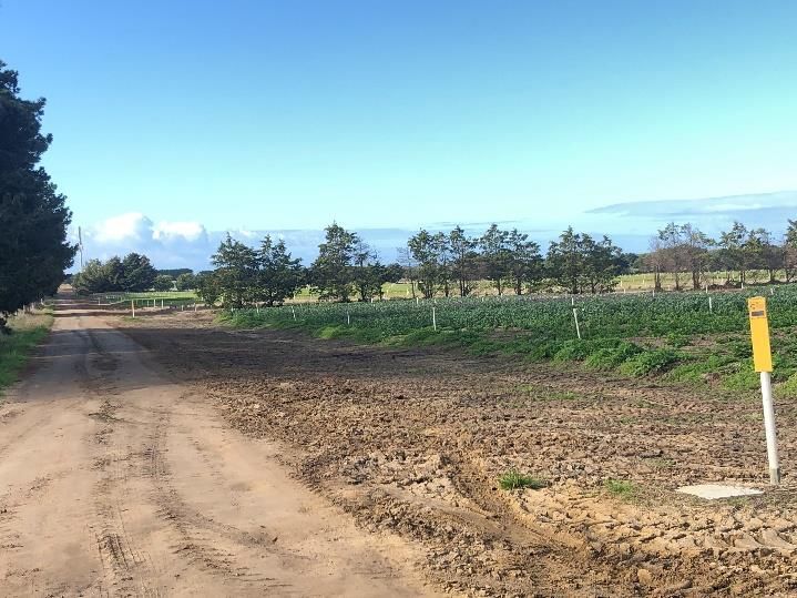
•   The Commonwealth Department of Agriculture, Water and the Environment (DAWE) Protected
        Matters Search Tool (PMST) for matters of National Environmental Significance (NES) protected under
        the Environment Protection and Biodiversity Conservation Act 1999 (EPBC Act) (DAWE 2020);

    •   Relevant listings under the Victorian Flora and Fauna Guarantee Act 1988 (FFG Act), including the
        latest Threatened and Protected Lists (DELWP 2018b; DELWP 2017a);

    •   The online VicPlan Map (DELWP 2020d) to ascertain current zoning and environmental overlays in the
        Investigation Area;

    •   Aerial photography of the Investigation Area;

    •   Any relevant reports, legislation and policy, including:

            o   VPA Reports;

            o   Ramsar Plans;

            o   Published and unpublished reports (i.e. consultant reports);

            o   National species Recovery Plans;

            o   Conservation advice; and,

    •   Previous ecological assessments relevant to the Investigation Area; including;

            o   Report on the vegetation of the Golden Woods Development site near Point Impossible. Mark
                Trengrove 1998.

            o   Torquay Sands Development: Surface Water Management System. Neil M. Craig Pty Ltd 2001.

            o   Flora and Fauna Assessment and Environmental Management Plan for Torquay Sands
                Residential Lakes and Golf Course Development, Torquay. Ecology Australia 2001.

            o   Report for Stormwater Master Plan: Torquay North. Prepared for Surf Coast Shire. GHD 2010.

2.3     Field Assessment
A detailed field assessment was undertaken on 16 July 2020 by a qualified ecologist to determine current
conditions with reference to findings of the desktop review. All fieldwork was completed in accordance with
a project specific Safe Work Method Statement (SWMS) and under relevant scientific licences and animal
ethics clearances.
The field assessment consisted of on-ground visual assessment from roadsides and public land to verify the
accuracy of the desktop assessment and determine the quality of vegetation present within the Investigation
Area. For each parcel in the Investigation Area, the existing and any past land management practices and any
impacts on biodiversity values were recorded, particularly areas which have been cultivated.
Where on-ground access was permitted, the following was undertaken:
    •   Identify and list all flora and fauna observed during the field assessment within the Investigation Area;

    •   Identify and list all native vegetation, including extant Ecological Vegetation Classes (EVCs) and
        scattered remnant trees;

    •   Identify the presence of any Matters of National Environmental Significance (NES);

                     Opportunities and Constraints Assessment: Torquay North East Investigation Area          9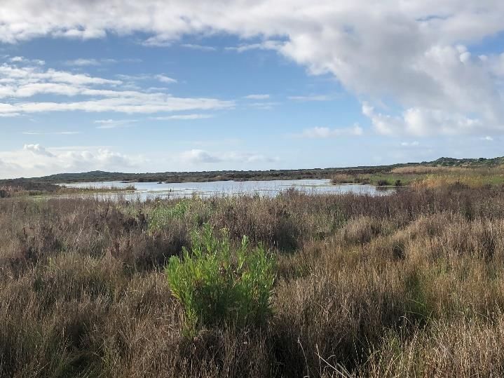
•   Identify and describe habitat for significant flora and fauna;

    •   Undertake a habitat hectares assessment of the native vegetation within the Investigation Area, in
        accordance with the Vegetation Quality Assessment Manual;

    •   Record site and vegetation information including:

            o    the address of the property;

            o    photographs (dated) and description of the native vegetation;

            o    copy of any property vegetation plan that applies to the site and details of any other native
                 vegetation that was permitted to be removed from the property.

Prior to undertaking the field assessment at the Torquay North East Future Residential Investigation Area,
locations of significant flora and fauna previously documented near the Investigation Area were visited as a
reference. The Parks Victoria Ranger Team Leader (Bellarine), Brooke Connor, was engaged to escort the
ecologist through the Breamlea Flora and Fauna Reserve and associated Karaaf Wetlands, with particular time
spent at the areas bordering the Sands development. This field assessment was undertaken to gain a further
understanding of current storm water impacts on this area of conservation significance.

2.4 Removal, Destruction or Lopping of Native Vegetation
Under the Planning and Environment Act 1987, Clause 52.17 of the Surf Coast Shire Planning Scheme requires
a planning permit to remove, destroy or lop native vegetation. The assessment process for the clearing of
vegetation follows the ‘Guidelines for the removal, destruction or lopping of native vegetation’ (the Guidelines)
(DELWP 2017b).

2.5     Assessment Qualifications and Limitations
This report has been written based on the quality and extent of the ecological values and habitat considered
to be present or absent at the time of the desktop and field assessments being undertaken.

The ‘snapshot’ nature of a standard biodiversity assessment meant that migratory, transitory or uncommon
fauna species may have been absent from typically occupied habitats at the time of the field assessment. In
addition, annual or cryptic flora species such as those that persist via underground tubers may also be absent.

To overcome this, the likely presence of threatened species was determined since this is a more conservative
approach and likely to include species that are difficult to detect. This precautionary approach will also account
for any assessment which are completed outside the optimal time for detecting a species, and it would be
assumed the species is present if suitable habitat was observed.
A comprehensive list of all terrestrial flora and fauna present within the Investigation Area was not undertaken
as this was not the objective of the assessment. Rather a list of commonly observed species was recorded to
inform the habitat hectare assessment and assist in determining the broader biodiversity values present within
the Investigation Area.

Most ecological values within the Torquay North East Future Residential Investigation Area were determined
by on-ground visual assessment from roadsides and public land to verify the accuracy of the desktop
assessment and determine the quality of vegetation present within the Investigation Area. The majority of the

                     Opportunities and Constraints Assessment: Torquay North East Investigation Area           10
Investigation Area was inaccessible and/or located on private land at the time of assessment. As such, visual
assessments and photographs were taken from or along the following locations:
• Horsehoe Bend Road;
• Swallowtail Drive; and,
• The driveway into the Investigation Area, located along the northern boundary.
Areas of native vegetation with on-site access were recorded using a hand-held GPS or tablet with an accuracy
of +/-5 metres. These levels of accuracy are considered to provide an accurate assessment of the ecological
values present within the Investigation Area; however, this data should not be used for detailed surveying
purposes.
Targeted flora or fauna surveys were not undertaken, as this was beyond the preliminary scope of the project.
However, prior to undertaking the ground truthing and native vegetation assessments, locations of significant
flora and fauna previously documented in close proximity to the Investigation Area were visited as a reference,
to determine their likelihood of occurring within the Investigation Area.
Nevertheless, the terrestrial flora and fauna data collected during the field assessment and information
obtained from relevant desktop sources is considered to adequately inform an accurate assessment of the
potential ecological values present within the Investigation Area.
The Breamlea Flora and Fauna Reserve
The Breamlea Flora and Fauna Reserve was also visited as part of the assessment regarding potential offsite
impacts on broader ecological values within the area. Whilst a formal habitat hectare assessment was not
undertaken within the reserve as this was beyond the scope of the study, notes on the general extent and
condition of vegetation were recorded, as well as any potential habitat for significant fauna species and any
observed impacts to the reserve, relating to stormwater overflow, from neighbouring developments.
Opportunities and Constraints Assessment: Torquay North East Investigation Area 113 RESULTS
3.1 Desktop Assessment
3.1.1 Native Vegetation
Extant vegetation mapping (2005) using the NatureKit Map (DELWP 2020b) identifies that the Investigation
Area is modelled to support one Ecological Vegetation Class: Grassy Woodland (EVC 175).
Endangered Grassy Woodland is modelled to border the western boundary of the Investigation Area, along
Horseshoe Bend Road where it is adjacent to low density residential housing (Plate 1). Most of the Investigation
Area is modelled to comprise of exotic vegetation present as agricultural pastures and windrows (Plate 2).
Plate 1. Ecological Vegetation Class (Grassy Woodland Plate 2. Extent of native vegetation cover (green) and
EVC 175 brown colour) modelled to occur within the exotic tree cover (pink) modelled to occur within the
Investigation Area (DELWP 2020b, sourced 14/07/2020). Investigation Area (DELWP 2020b, sourced 14/07/2020).
3.2 Field Assessment
An assessment of the Investigation Area, carried out from available observation points, primarily consisting of
roadsides, indicated that the Investigation Area was entirely modified, and that no native vegetation was
present on site.
Introduced and planted vegetation across the Investigation Area, were generally present as:
• Cropping/agriculture: land primarily used for cropping and/or agriculture with no native vegetation
present.
• Non-native Shelterbelt: plantings of non-native species; primarily Cypress Pines as
windbreaks/shelterbelts.
• Mixed species Shelterbelt: plantings of mixed local indigenous and non-indigenous species.
Shelterbelts are planted mostly along property boundaries.
Opportunities and Constraints Assessment: Torquay North East Investigation Area 12• Property gardens: established gardens around buildings and residences, generally consisting of
ornamental plantings.
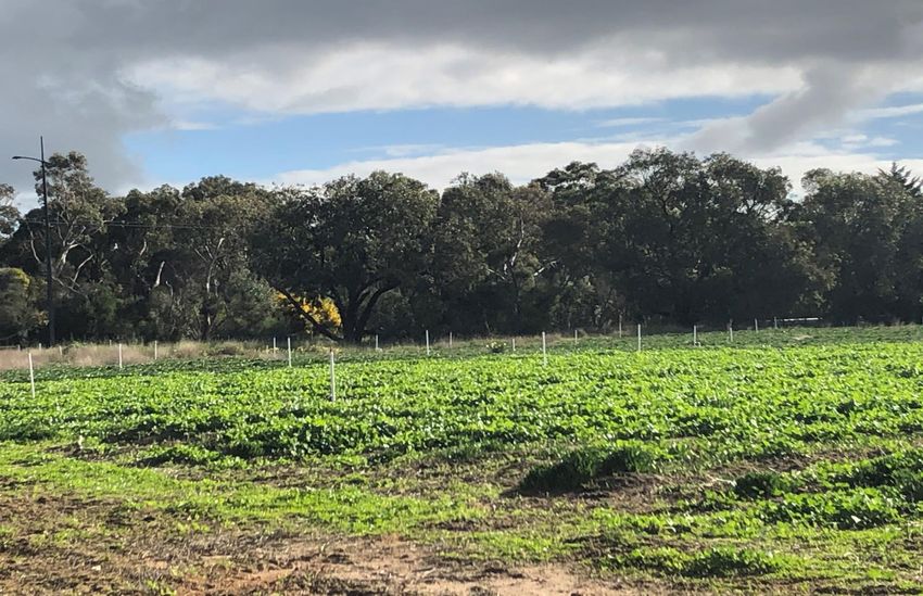
Areas of cropping / agriculture, were present throughout the Investigation Area, and were noticeably ploughed
and had no native vegetation value (Plate 3; Plate 4). The vegetation cultivated within this area appeared to
be uniform with the adjacent Flower Farm.
Substantial shelterbelts or windbreaks of planted non-indigenous and/or mixed native Eucalypts were typically
present between paddocks and along fence lines (Plate 5). The exotic tree species typically seen was Radiata
Pine Pinus radiata.
The road reserves at which the visual assessments were undertaken, namely along Horseshoe Bend Road and
at the end of Swallowtail Drive, were dominated by exotic vegetation, such as Yorkshire Fog Holcus lanatus,
Cocksfoot Dactylis glomerata, Soursob Oxalis pes-caprae and Common Sow-thistle Sonchus oleraceus (Plate
6).
Overall, vegetation within the Torquay North East Future Residential Investigation Area was assessed to be
substantially modified as a result of repeat cultivation and is considered to be of low ecological value.
Plate 3. View of Investigation Area from northern Plate 4. View of Investigation Area from the end of
boundary (Ecology and Heritage Partners Pty Ltd Swallowtail Drive (Ecology and Heritage Partners Pty
16/07/2020). Ltd 16/07/2020).
Opportunities and Constraints Assessment: Torquay North East Investigation Area 13Plate 5. Cypress Pine dominated windbreak along the Plate 6. Exotic groundcover vegetation within the
western boundary of the Investigation Area (Ecology and Investigation Area (Ecology and Heritage Partners Pty
Heritage Partners Pty Ltd 16/07/2020). Ltd 16/07/2020).
3.3 Fauna Habitat
Eucalypt (Eucalyptus spp.) trees planted within mixed shelterbelts will provide foraging habitat for frugivorous
(fruit-eating) bird species. Few eucalypts appeared to be mature, but those that are may provide an array of
small, medium and large hollows, bark fissures and crevices, likely to be used for shelter and nesting by a range
of hollow-dependent fauna, including parrots, microbats, possums, gliders and owls.
The majority of the Investigation Area consists of cultivated areas which contain improved exotic pastures,
likely to be used as a foraging resource by common generalist bird species which are tolerant of modified open
areas.
Furthermore, a large dam to the south-west corner of the Investigation Area is mapped as a Current Wetland.
It is understood that this dam is a retarding basin used to capture stormwater flows emanating from The Sands
development. Although inaccessible at the time of the field assessment, this wetland area has the potential to
provide habitat for a range of animals that rely on regular standing water during part of the year to provide
food and other resources, such as aquatic invertebrates, frogs, reptiles and waterbirds (TSSC 2012).
3.4 Breamlea Flora and Fauna Reserve (and Karaaf Wetlands)
The Breamlea Flora and Fauna Reserve is a large, open reserve dominated by endangered Coastal Saltmarsh
(EVC 9) and includes the adjacent Karaaf Wetlands (Breamlea Association 2020). Thompsons Creek also flows
through the saltmarsh in the Breamlea and Karaaf Wetlands to the sea.
Coastal Saltmarsh typically occurs on and immediately above marine and estuarine tidal flats and contains
distinct floristic communities as bands or zones in the same location, depending on the positioning of the
various floristic communities in relation to the saline environment (DELWP 2020c). Coastal Saltmarshes are
essentially coastal wetlands that are flooded and drained by saltwater brought in by the tides. The soil in these
areas are composed of deep mud and peat (decomposing plant matter).
Coastal Saltmarsh within the Breamlea Flora and Fauna Reserve consisted of a range of life forms including
succulent herbs, low succulent shrubs, rushes and sedges, namely Beaded Glasswort Sarcocornia quinqueflora
Opportunities and Constraints Assessment: Torquay North East Investigation Area 14subsp. quinqueflora, Marsh Saltbush Atriplex paludosa subsp. paludosa, Coast Beard-heath Leucopogon
parviflorus and Seaberry Saltbush Rhagodia candolleana subsp. candolleana (Plate 6).
Saltmarsh environments provide important fauna habitat, in terms of breeding habitat for numerous fish
species such as Black Bream Acanthopagrus butcheri and Gobies Pseudogobius spp., and shallow foraging
areas for migratory bird species such as the White-faced Heron Egretta novaehollandiae, which was observed
during the field assessment.
Eastern Grey Kangaroos Macropus giganteus was observed to be within the reserve as well (Plate 7). However,
it was noted that their primary habitat was in the adjacent farmlands where there was abundant feed.
The field assessment also noted an influx of freshwater into the Karaaf Wetlands, emanating from the adjacent
Sands development (Plate 8). The water was observed to be flowing into the reserve area from two points; a
pipeline and a floodway. Large expanses of freshwater covered previously exposed areas of Beaded Glasswort
and freshwater species (e.g. Senecio spp.) were already established around these areas (Plate 9). In areas
where freshwater had previously retreated, saltmarsh groundcover species were also noted to be experiencing
dieback, with very little regeneration observed (Plate 10). This reduction in the quality and extent of saltmarsh
has severe implications for a number of fauna species which rely on the saltmarsh for foraging and breeding
habitat.
Whilst the permanent saline wetlands and associated saltmarsh environments dominated the Breamlea
Reserve, the Coastal Dune Scrub/Coastal Dune Grassland Mosaic dominated areas closer to the shoreline,
providing habitat for many shore birds, including the threatened Hooded Plover (Plate 11). The flora species
that dominated these areas included Coast Tea-tree Leptospermum laevigatum, Coast Beard-heath
Leucopogon parviflorus, Coast Sword Sedge Lepidosperma gladiatum, Chaffy Saw-sedge Gahnia filum and
Coast Blown-grass Lachnagrostis billardierei s.l.
Plate 6. Coastal Saltmarsh within the Breamlea Flora and Plate 7. Eastern Grey Kangaroo within the Breamlea
Fauna Reserve (Ecology and Heritage Partners Pty Ltd Flora and Fauna Reserve (Ecology and Heritage Partners
16/07/2020). Pty Ltd 16/07/2020).
Opportunities and Constraints Assessment: Torquay North East Investigation Area 15Plate 8. Freshwater inundation into the Breamlea Flora Plate 9. Freshwater flora species emerging within the
and Fauna Reserve (Ecology and Heritage Partners Pty Ltd Coastal Saltmarsh (Ecology and Heritage Partners Pty
16/07/2020). Ltd 16/07/2020).
Plate 10. Evident dieback of Saltmarsh flora species where Plate 11. Coastal Dune Scrub along the shorelines of the
freshwater has retreated (Ecology and Heritage Partners Breamlea Flora and Fauna Reserve (Ecology and
Pty Ltd 16/07/2020). Heritage Partners Pty Ltd 16/07/2020).
3.5 Removal of Native Vegetation (the Guidelines)
Under the Planning and Environment Act 1987, Clause 52.17 of the Planning Schemes requires a planning
permit from the relevant local Council to remove, destroy or lop native vegetation.
3.5.1 Vegetation proposed to be removed
The information pertaining to the quality and extent of any ecological values within the boundaries of the
Torquay North East Future Residential Investigation Area will be used to inform decisions about the future of
the development area and assist the DELWP facilitate the strategic planning process. It is also understood that
this information will assist decisions on the retention, removal and/or offsetting of native vegetation and fauna
habitat.
Opportunities and Constraints Assessment: Torquay North East Investigation Area 16As such, there are no plans presently in place for the development of the Investigation Area. This assessment
revealed that there were no areas of native vegetation within the Investigation Area. However, it is important
to note that there were areas, such as along the eastern boundary, that were unable to be assessed due to
access constraints.
The retarding basin in the south-east corner of the Investigation Area is mapped as a Current Wetland. This
area should be assessed regarding the extent and condition of native vegetation, and the corresponding offset
requirements associated with the removal of native vegetation within the Investigation Area can then be
determined.
3.6 Significance Assessment
3.6.1 Flora
The VBA contains records of four (4) nationally significant and 34 State significant flora species previously
recorded within 10 kilometres of the Investigation Area (DELWP 2018a) (Figure 3). The PMST nominated an
additional 13 nationally significant species which have not been previously recorded but have the potential to
occur in the locality (DAWE 2020).
While there are multiple records of significant flora species within 10 kilometres of the Investigation Area,
there are no recorded occurrences within the Investigation Area itself. Based on the site assessment, modified
nature of the Investigation Area, landscape context and the proximity of previous records, significant flora
species are considered unlikely to occur within the Investigation Area due to the and high levels of disturbance
and absence of suitable habitat.
However, two State-significant flora species are highly likely to occur within the Breamlea Flora and Fauna
Reserve: Coast Wirilda Acacia uncifolia and Creeping Rush Juncus revolutus. Both these species have previously
been confirmed in the area now housing the Sands Development, and given the distribution of records and
habitat encountered during the site visit, it is highly likely that these species are also present throughout the
Breamlea Flora and Fauna Reserve.
It is also likely that other significant flora species occur within the Breamlea Flora and Fauna Reserve, despite
the absence of previous records. However, this may not indicate the absence of the listed species but may
simply reflect the lack of detailed flora survey in the area. Further detailed surveys are required to confirm the
presence of any other national or State significant flora.
3.6.2 Fauna
The VBA contains records of 28 nationally significant and 43 State significant fauna species previously recorded
within 10 kilometres of the Investigation Area (DELWP 2018a) (Figure 4). The PMST nominated an additional
28 nationally significant species which have not been previously recorded but have the potential to occur in
the locality (DAWE 2020).
No records of significant fauna species were identified within the Investigation Area. However, Growling Grass
Frog Litoria raniformis has the potential, albeit low likelihood, to occur within the retarding basin in the south-
east corner of the Investigation Area. In Victoria and the south-east of South Australia, the species is usually
found among vegetation within or at the edges of permanent water such as slow flowing streams, swamps,
lagoons and lakes. Potential habitat for the species is present in the waterbody/dam (mapped as a Current
Opportunities and Constraints Assessment: Torquay North East Investigation Area 17Wetland) in the south-east corner of the Investigation Area. If future development is expected to have impacts
to this waterbody, targeted surveys for this species should be undertaken.
Based on species habitat requirements, previous records, and distribution across the landscape, the following
significant species have medium or higher likelihood of occurring within the Breamlea Flora and Fauna Reserve
and associated Karaaf Wetlands (Table 4):
Table 4. Significant Fauna Species which may occur within the Breamlea Flora and Fauna Reserve
Common
Scientific Name Habitat
Name
National Significance
Orange- Neophema The Orange-bellied Parrot has a restricted distribution: breeding only in south-
bellied chrysogaster western Tasmania in spring and summer, then migrating to coastal Victoria and
Parrot South Australia for the winter. Most of the population winters around the western
shores of Port Phillip Bay and the Bellarine Peninsula in Victoria.
During winter, the Orange-bellied Parrot feeds on the ripe or developing seeds of
several saltmarsh or coastal herbs and shrubs, in particular Beaded Glasswort
Sarcocornia quinqueflora subsp. quinqueflora.
The main factor threatening the Orange-bellied Parrot are habitat loss and
fragmentation resulting from development (particularly feeding grounds), with
the widespread destruction of wintering habitat thought to be a critical factor in
the decline of the species to its current low population levels.
The saltmarsh within the Breamlea Flora and Fauna Reserve is a known Orange-
bellied Parrot site and is considered critical or ‘core habitat’ for the species in the
region.
Hooded Thinornis rubricollis In eastern Australia, the Hooded Plover occurs on ocean beaches and open salt
Plover lakes immediately behind these beaches, and breeds above the high tide mark or
in sheltered, unvegetated dunes behind the beach (Marchant and Higgins 1993).
The Hooded Plover feeds on sandy ocean beaches, particularly among beach-
washed seaweed and on rocky shore platforms where it takes a range of food,
including crustaceans, shellfish and insects (Marchant and Higgins 1993).
Hooded Plover have been previously recorded in the Breamlea Flora and Fauna
Reserve, particularly along Thompsons and adjacent creeks.
Migratory - A number of migratory birds and shorebirds protected under the EPBC Act are
Birds likely to utilise habitat within and near to the Breamlea Flora and wetlands.
Potential habitat for these listed species occurs in the saltmarsh and Thompson
Creek, which flows through the Breamlea Flora and Fauna Reserve.
A number of these species have previously been observed or recorded within the
area.
State Significance *
Pied Phalacrocorax varius In Victoria, the Pied Cormorant occurs on large freshwater and saline wetlands as
Cormorant well as tidal bays along the coast.
Pied Cormorant has been previously recorded further along the coastline
towards Buckley Bay. While there are no known breeding colonies within the
Breamlea Flora and Fauna Reserve, Thompson Creek and the Karaaf Wetlands
provide suitable foraging habitat.
Birds may also utilise and move through this area en route to Lake Connewarre
where other sightings have been recorded.
Opportunities and Constraints Assessment: Torquay North East Investigation Area 18Common
Scientific Name Habitat
Name
Caspian Hydroprogne caspia The Caspian Tern is widespread in all coastal regions of mainland Australia and
Tern Tasmania. Habitat typically includes exposed beaches where it feeds, and more
sheltered estuaries and bays.
Several records exist from the Breamlea area and the larger area (Thompson
Creek and the Beach/Foreshore) provides suitable roosting and foraging habitat.
Eastern Ardea modesta Preferred habitat of the Eastern Grey Egret includes terrestrial wetlands,
Great Egret estuarine and littoral areas as well as tidal reaches of watercourses, saltmarshes
and dry saltpans (Marchant and Higgins 1990).
The Eastern Grey Egret has been observed at the Thompsons Creek Estuary and
areas within the Breamlea Flora and Fauna Reserve, including the saltmarsh,
provide suitable foraging habitat.
Common Tringa nebularia Common Greenshanks are found both on the coast and inland, in estuaries and
Greenshank mudflats, mangrove swamps and lagoons.
The saltmarsh, the edges of Thompson Creek and the beach/foreshore provide
protentional roosting and foraging habitat for this migratory wader, where
previous observations have been recorded.
Note. * Those species with the highest likelihood of occurrence.
3.6.3 Communities
3.6.3.1 Nationally Significant
Seven nationally listed ecological communities have the potential to occur within 10 kilometres of the
Investigation Area (DAWE 2020).
• Assemblages of species associated with open-coast salt-wedge estuaries of western and central
Victoria ecological community.
• Giant Kelp Marine Forests of South East Australia;
• Grassy Eucalypt Woodland of the Victorian Volcanic Plain;
• Natural Damp Grassland of the Victorian Coastal Plain;
• Natural Temperate Grassland of the Victorian Volcanic Plain;
• Seasonal Herbaceous Wetlands (Freshwater) of the Temperate Lowland Plains; and,
• White Box-Yellow Box-Blakely’s Red Gum Grassy Woodland and Derived Native Grassland.
Vegetation within the Torquay North East Future Residential Investigation Area does not meet the condition
thresholds that define any nationally significant communities. Further, given the vegetation type and condition
on site, no FFG Act listed vegetation communities are considered present.
However, the Assemblages of species associated with open-coast salt-wedge estuaries of western and central
Victoria ecological community (referred to hereafter as the Salt-wedge Estuaries ecological community) is
considered to occur within the Breamlea Flora and Fauna Reserve (TSSC 2018).
Furthermore, based on the EVC predicted, and the subsequent field assessment, the Subtropical and
Temperate Coastal Saltmarsh ecological community may also occur within the Breamlea Flora and Fauna
Opportunities and Constraints Assessment: Torquay North East Investigation Area 19Reserve in areas comprising the Coastal Saltmarsh EVC. Further investigation is required to confirm the
potential quality and extent of this community.
Assemblage of species associated with open-coast salt-wedge estuaries of western and central Victoria
ecological community
Due to the dynamic nature of the Salt-wedge Estuaries ecological community and the importance of
longitudinal and lateral connectivity, it has been determined that condition thresholds do not apply (TSSC
2018).
However, the ecological community is typically defined as the assemblage of native plants, animals and micro-
organisms associated with the dynamic salt-wedge estuary systems that occur within the temperate climate,
microtidal regime (< 2 m), high wave energy coastline of western and central Victoria (TSSC 2018).
The ecological community currently encompasses 25 estuaries in the region defined by the border between
South Australia and Victoria and the most southerly point of Wilsons Promontory, one of which is Thompson
Creek, which flows through the Breamlea Flora and Fauna Reserve.
This estuary and their surrounding saltmarsh wetlands are highly productive areas and ecologically important
as they provide habitat and resources for biota, including spawning and nursery areas for fish and invertebrate
species, and breeding and foraging areas for birds.
Subtropical and Temperate Coastal Saltmarsh ecological community
The ecological community consists of organisms including and associated with saltmarsh in coastal regions of
sub-tropical and temperate Australia and typically occurs in coastal areas under regular or intermittent tidal
influence.
The Subtropical and Temperate Coastal Saltmarsh ecological community is likely to occur within the Breamlea
Flora and Fauna Reserve. It is typically characterized by the following characteristics that define this
community:
• Occurs south of 23° 37' S latitude - from the central Mackay coast on the east coast of Australia,
southerly around to Shark Bay on the west coast of Australia (26° latitude), and including the
Tasmanian coast and islands within the above range
• Occurs on the coastal margin, along estuaries and coastal embayments and on low wave energy coasts
• Occurs on places with at least some tidal connection, including rarely-inundated supratidal areas,
intermittently opened or closed lagoons, and groundwater tidal influences, but not areas receiving
only aerosol spray
• Occurs on sandy or muddy substrate and may include coastal clay pans (and the like); and,
• Consists of dense to patchy areas of characteristic coastal saltmarsh plant species (i.e. salt- tolerant
herbs, succulent shrubs or grasses, that may also include bare sediment as part of the mosaic); and,
• Proportional cover by tree canopy such as mangroves, Melaleucas or Casuarinas is not greater than
50%, nor is proportional ground cover by seagrass greater than 50%.
The ecological community is inhabited by a wide range of infaunal and epifaunal invertebrates, and low-tide
and high-tide visitors such as prawns, fish and birds (TSSC 2013). It often constitutes important nursery habitat
for fish and prawn species. Insects (terrestrial and aquatic, including nuisance mosquitoes and midges) are
Opportunities and Constraints Assessment: Torquay North East Investigation Area 20abundant and an important food source for other fauna, with some species being important pollinators (TSSC
2013).
4 KNOWN AND LIKELY IMPACTS
The Torquay North East Future Residential Investigation Area is an already disturbed agricultural area, with
only exotic and planted vegetation recorded within the site. However, any proposed development within the
Investigation Area will still directly impact on indigenous flora and fauna species, and communities recorded
within and adjacent to the Investigation Area.
These impacts may include:
• Loss of habitat and potential mortality for locally common fauna species dependent on wetlands or
inundated areas for foraging, shelter or nesting (e.g. aquatic or wading birds, frogs, microbats);
• Potential for further habitat fragmentation in a fragmented landscape and the associated creation of
barriers to the movement and migration of indigenous fauna;
• Potential for the spread of weeds and soil pathogens due to on-site activities;
• Disturbance to wildlife from increased human activity and noise during operation; and,
• Indirect impacts on adjacent areas if operational activities and drainage are not appropriately
managed
Of particular concern, is the off-site ecological impacts to the Breamlea Flora and Fauna Reserve as a result of
stormwater run-off from any future urban development within the Torquay North East Future Residential
Investigation Area.
The existing urban development has already altered the natural hydrological cycle of the area. As urban
structures such as rooftops, roads, driveways and buildings have been built, the amount of area impervious to
rainfall has increased. This, in turn, increased the peak run-off flow rate during rainfall events and increased
the total run-off volume (Venant Solutions 2015, 2018). As a result, due to the topography of the area, any
stormwater run-off ultimately flows into the Breamlea Flora and Fauna Reserve.
Wetlands only have a limited capacity for handling increased flows or additional pollutant loadings and
excessive stormwater discharge on a continuous basis has the potential to alter wetland hydrology,
topography, and the vegetative community (Venant Solutions 2015,2018; Lloyd et al 2011). Urbanisation will
also increase the type and amount of pollutants in surface runoff loads over predevelopment levels.
The increase in run-off flow to the Breamlea Flora and Fauna Reserve has already changed the ecological
character of the area in terms of an influx of freshwater into the saltwater wetland and the encroachment of
freshwater plant species as a result of the existing developments within the immediate area. A further increase
in stormwater run-off from any future residential development will only serve to exacerbate these negative
impacts, which include but are not limited to the loss of native vegetation and critical habitat for migratory
bird species.
The Torquay North Stormwater Masterplan (Flood Flow Updates) (2020) has previously recommended that
Council consider the potential effect on areas downstream an increase in peak flood flows will have and
Opportunities and Constraints Assessment: Torquay North East Investigation Area 21whether any further investigation is required. In order to prevent the impacts of increases in water volume
on the Breamlea Flora and Fauna Reserve, adequate stormwater management techniques should be
implemented. Further discussion of proposed measures is provided in Section 5.
Opportunities and Constraints Assessment: Torquay North East Investigation Area 225 STORMWATER MANAGEMENT TECHNIQUES
The Breamlea Flora and Fauna Reserve already receives run-off flow from nearby developments, which has
resulted in a change to the ecological character of the wetland. The future development of the Torquay North
East Investigation Area is highly likely to exacerbate these ecological impacts, unless adequate stormwater
prevention measures are implemented.
Possible actions to control and manage stormwater are provided below. The determination, however, of which
action (if any) to be implemented is dependent on the outcomes of a detailed hydrological assessment, which
will confirm if no direct/indirect storm water runoff into the Breamlea Flora and Fauna Reserve can be
achieved. This hydrology assessment is needed before any development can be progressed.
Actions to control and manage stormwater may include, but are not limited to (GHD 2010):
• Concentrating the areas of development to accommodate upland stormwater management, which
can include:
o Retarding basins; and/or,
o Wetland systems.
• Diverting stormwater flows around the wetland through the construction of a stormwater bypass
channel.
The construction of retarding basins and wetland systems would assist to capture water flows from local
stormwater drainage networks and overland flows from roads. Such methods would allow the captured
surface water to be reused or repurposed to irrigate any park lands or recreation reserves within a future
development.
However, as seen with the Sands development, these stormwater management techniques may be considered
adequate to mitigate impacts from the development itself, however, cannot account for discharges emanating
from lands external to its boundaries. As such, as future developments are created, it is likely that any future
stormwater catchments within the Torquay North East Investigation Area will be insufficient to capture all
surrounding runoff and stormwater will still be discharged into the Breamlea Flora and Fauna Reserve.
An alternative solution is the construction of a stormwater bypass channel to connect the proposed future
development to the ocean, in order to allow stormwaters to bypass the Breamlea Flora and Fauna Reserve.
However, the construction of a channel into the ocean may still have the potential for ecological impacts on
the Coastal Dune areas. Where feasible, alternative diversion routes should be considered, such as to the
adjoining Flower Farm or adjacent farmland, where there is potential reuse for the water to increase farm
productivity.
It is recommended that a hydrological assessment of the area and surrounds (particularly the Breamlea Flora
and Fauna Reserve) be undertaken by a qualified engineer. This assessment will assist to inform the
appropriate stormwater management technique to prevent impacts caused by an increase in volume and
intensity of stormwater run-off.
Opportunities and Constraints Assessment: Torquay North East Investigation Area 236 ENHANCING BIODIVERSITY
A summary of practically achievable ecological enhancement opportunities to be considered as part of the
planning process for any future development within the Torquay North East Future Residential Investigation
Area is provided below:
6.1.1 Revegetation/Replanting Works
Through strategic revegetation activities, there is an opportunity to increase the biodiversity within the
Torquay North East Future Residential Investigation Area and re-introduce suitable habitat for avian and
arboreal fauna back into the site.
In order to ensure any revegetation activities most closely represents the indigenous EVC formerly present
within the Investigation Area, it is recommended that plantings are conducted using indigenous species typical
of the Grassy Woodland EVC (EVC 175) and that sourced from a local provenance.
6.1.2 Habitat Creation
Nest Boxes
Many species of wildlife rely on natural tree hollows for nesting, breeding and shelter. Hollows provide a safe
home away from the weather and predators. In eucalypt trees, small hollows may take over 70 years to
develop and large hollows many decades longer.
Nest boxes of varying types and sizes are an important aspect to wildlife conservation in that they provide
additional habitat for hollow-dependant fauna in areas where hollows are in short supply, and in addition,
support the persistence or reintroduction of a species in any areas where natural nesting hollows are not
available.
There is an opportunity to re-introduce fauna into the Investigation Area through the installation and creation
of fauna habitat within potential parkland or reserves as part of a future development of the area.
Logs
Logs provide an excellent habitat and food for many species and are extremely important for the proper
function of a healthy ecosystem. Frogs, reptiles and small mammals use logs with hollows for shelter and a
food resource. It is recommended that any trees that are proposed to be impacted by any future development
within the Investigation Area are repurposed for use as habitat logs within any future parks or reserves created
as part of the development.
6.1.2.1 Weed Control
Weeds are present throughout the Investigation Area and will be required to be controlled as part of the
revegetation and enhancement works.
Within the areas proposed for revegetation, the highest priority for weed control should be WONS and noxious
weeds. Landowners of adjacent areas are responsible for the control of any infestation of noxious weeds to
minimise their spread and impact on ecological values under the Catchment and Land Protection Act 1994
Opportunities and Constraints Assessment: Torquay North East Investigation Area 24You can also read