Overview No.57-February2021 www.cropmonitor.org - GEOGLAM Crop Monitor
←
→
Page content transcription
If your browser does not render page correctly, please read the page content below

No. 57 – February 2021                                 www.cropmonitor.org

                        Overview

Overview:
In East Africa, harvesting of main season cereals finalized under favourable
conditions while second season cereals have been harvested with reduced
outputs in areas impacted by below-average rainfall, desert locusts, flooding,
and ongoing socio-economic challenges. In West Africa, harvesting of main
and second season cereals finalized throughout the subregion under
favourable conditions except in areas impacted by ongoing conflict. In the
Middle East and North Africa, there is concern in parts of North Africa where
dry conditions are impacting winter wheat crop development and in Syria and
Libya where conflict continues to impact agricultural activities. In Southern
Africa, above-average rains have supported crop development across central
and southern areas; however, dry conditions persist in some areas, and
damage resulted from heavy rains and flooding from Tropical Cyclone Eloise.
In Central and South Asia, conditions are favourable for the planting and
development of winter wheat crops except in parts of Afghanistan,
Turkmenistan, and Uzbekistan where below-average precipitation is a
concern. In northern Southeast Asia, harvesting of wet-season rice finalized
in December under generally favourable conditions, and planting of dry-
season rice is underway with concern in some areas due to limited irrigation
water supply and flooding. In Indonesia, harvesting of dry-season rice
finalized with a large increase in harvested area. In Central America and the
Caribbean, harvesting of Postrera/Segunda season maize and bean crops
finalized in December, and crop losses resulted in parts of Nicaragua,
Guatemala, and Honduras due to Hurricanes Eta and Iota in November.
Apante season bean crops are developing under favourable conditions.

                                                                                 Contents:
                                                                                 Conditions at a Glance…………………………………….……………..…......2
                                                                                 Global Climate Outlook; Climate Influences ……………..…….……3
                                                                                 Desert Locust Alert; Seasonal Forecast Alert ……….………………..4
                                                                                 East Africa & Yemen; Regional Climate Outlook………………..…..6
                                                                                 West Africa………………………………………….……….………………..….……9
                                                                                 Middle East & North Africa.……………………..…….……………….……10
                                                                                 Southern Africa; Regional Climate Outlook ………………....……..11
                                                                                 Central & South Asia; Regional Climate Outlook ………….……..14
                                                                                 Southeast Asia; Regional Climate Outlook ………….……..….......…...16
                                                                                 Central America & Caribbean ……………………..…………………….……….19
                                                                                 Appendix – Terminology & Definitions……………….……….….....20

                                       The Crop Monitor is a part of GEOGLAM, a GEO global initiative.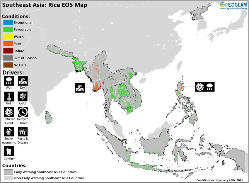
2         No. 57 – February 2021                                                                     Crop Monitor for Early Warning

GEOGLAM Crop Monitor for Early Warning
                                            Crop Conditions at a Glance
                       based on best available information as of January 28th

Crop condition map synthesizing information for all Crop Monitor for Early Warning crops as of January 28th. Crop conditions over the main growing
areas are based on a combination of inputs including remotely sensed data, ground observations, field reports, national, and regional experts. Regions
that are in other than favourable conditions are labeled on the map with a symbol representing the crop(s) affected.

EAST AFRICA: Harvesting of main season cereals finalized under               from Tropical Cyclone Eloise in late January (See Regional
generally favourable conditions while second season maize and                Outlook Pg. 13).
sorghum crops have been harvested with reduced outputs in                    CENTRAL & SOUTH ASIA: Planting and development of winter
countries impacted by below-average rainfall, the desert locust              wheat crops is underway under favourable conditions except in
outbreak, flooding, and socio-economic challenges (See Desert                parts of Turkmenistan, Uzbekistan, and Afghanistan where
Locust Alert Pg. 4 and Regional Outlook Pg. 8). Below-average                below-average rainfall has been received and is forecast to
rainfall is also expected across parts of the region for the                 continue (See Regional Outlook Pg. 15). In Pakistan, harvesting
upcoming 2021 March to May (MAM) season owing to the                         of main season rice crops finalized in December under
presence of La Niña conditions (See Seasonal Forecast Alert Pg.              favourable conditions.
5).                                                                          SOUTHEAST ASIA: In the north, harvesting of wet-season rice
WEST AFRICA: Harvesting of main and second season cereals                    finalized in December under favourable conditions except in
finalized throughout the subregion under favourable conditions               parts of Myanmar and the Philippines due to dry conditions and
except in areas with dry conditions and ongoing conflict.                    crop damage resulting from seasonal monsoons and typhoons.
MIDDLE EAST & NORTH AFRICA: Wheat crops are in vegetative                    Planting of dry-season rice is underway with concern in some
to reproductive stage for harvest from May onwards, and there                areas due to limited irrigation water availability and flooding. In
is concern in parts of North Africa where dry conditions are                 Indonesia, harvesting of dry-season rice finalized under
impacting crop development and throughout Syria and Libya                    favourable conditions, and sowing of wet-season rice is
where conflict and socio-economic concerns continue to impact                underway with a significant increase in sown area.
agricultural activities.                                                     CENTRAL AMERICA & CARIBBEAN: Harvesting of
SOUTHERN AFRICA: Planting and development of main season                     Postrera/Segunda season maize and bean crops finalized in
cereals continued throughout the subregion. While rainfall has               December, and crop losses resulted in parts of Nicaragua,
been above-average across central and southern areas, there is               Guatemala, and Honduras due to Hurricanes Eta and Iota in
concern in several areas due to persistent dry conditions. There             November. Apante season bean crops are developing under
is also concern in central Mozambique due to potential impacts               favourable conditions.

                                              The Crop Monitor for Early Warning is a part of GEOGLAM,
                                                    a GEO global initiative. www.cropmonitor.org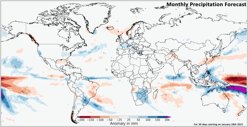
3       No. 57 – February 2020                                                                           Early Warning Crop Monitor

Global Climate Outlook: Global 30 -day Subseasonal Rainfall Forecast Anomaly for February 2021
The 30-day Subseasonal (SubX) forecast indicates a likelihood of above-average rainfall over California and the mid-Atlantic states
US, Suriname, French Guiana, east Paraguay, Southern Brazil, Uruguay, northeastern Argentina, central Chile, France, southern
Germany, Switzerland, Bosnia and Herzegovina, Montenegro, Albania, Botswana, Zambia, Zimbabwe, southern Mozambique,
eSwatini, central and eastern South Africa, Sri Lanka, the Philippines, and Indonesia. There is also a likelihood of below-average
rainfall across northeastern and southeast Brazil, Iceland, eastern Angola, eastern Madagascar, Afghanistan, northern Pakistan,
northwest India, southeast China, southern Japan, Sulawesi Indonesia, and northern Queensland Australia.

Multimodel mean subseasonal forecast of global rainfall anomaly for the 30-days starting from January 28th showing areas of above or below-average
rainfall. The image shows the average of four Subseasonal Experiment (SubX) model forecasts from that day. The anomaly is based on the 1999 to
2016 model average. Skill assessments of SubX can be accessed here.
Source: UCSB Climate Hazards Center

Climate Influences: La Niña is present and expected to continue through Spring 2021
The El Niño-Southern Oscillation (ENSO) is currently in the La Niña phase. This La Niña event is well-developed, with very cool ocean
conditions in the eastern equatorial Pacific. La Niña conditions are expected to continue (95% chance for January to March and 55%
chance for March to May) and then transition to ENSO neutral (55% chance for April to June).
La Niña conditions typically reduce February to March/May rainfall in East Africa, the southern United States, the northern Middle
East, southern Central Asia, Afghanistan, Pakistan, and India. La Niña conditions typically increase February to March/May rainfall in
Southeast Asia, Southern Africa, and in southernmost India and Sri Lanka. Southern Central America and northern South America
typically see increased rainfall into February.
Source: UCSB Climate Hazards Center

                                              The Crop Monitor for Early Warning is a part of GEOGLAM,
                                                  a GEO global initiative. www.cropmonitor.org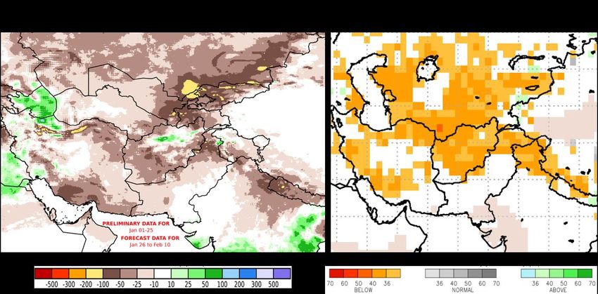
4      No. 57 – February 2021                                                                    Crop Monitor for Early Warning

Desert Locust Alert: Breeding is underway in southern Ethiopia and northern Kenya,
and more swarms are expected.
Heavy rains from Cyclone Gati in November created favourable conditions for new swarms to form in eastern Ethiopia and
central Somalia, and in late December, immature swarms from these areas moved to southern Ethiopia and northern Kenya
where local breeding is underway. In January, more swarms formed in eastern Ethiopia and central Somalia that migrated to
northeast and southern Ethiopia, Eritrea, Djibouti, Kenya, and Tanzania. Swarms are likely to decline in southern Ethiopia and
Kenya while new swarms may form in northern Somalia, and new groups and swarms may form on the Red Sea coast of Saudi
Arabia. A new generation of locusts is expected to emerge in early April, coinciding with seasonal rains and the planting period
in Kenya and southern Ethiopia. Breeding is underway along both sides of the Red Sea coast, and in Sudan and Eritrea, adult
groups and some swarms appeared on the coast and will cause hopper bands to form. In late January, several immature swarms
arrived on the Red Sea coast and in southwest Saudi Arabia.
East Africa Update
In Kenya, immatures swarms from the north arrived in the northeast in late December, and more swarms arrived in the northeast
along the Dawa River on the Ethiopian border and near El Wak and the Somalia border. Immature swarms are now spreading
west throughout north and central areas, and a few are starting to mature. In the southeast, fledging is underway near Taita
Taveta, and late instar hopper bands are present along the coast. Breeding near the Tanzania, Ethiopia, and Somalia borders has
resulted in egg-laying and band formations, and locusts have invaded farms and pastures and are threatening vegetation in
Taita-Taveta, Kilifi, and Tana River counties in the southeast. However, uneven rainfall distribution for the past four months has
resulted in a large moisture deficit over south and eastern areas of Kenya, causing poor vegetation coverage (See Regional
Outlook Pg. 8). More swarms from the north are expected to spread through northern and central areas, and there is a risk that
a few swarms could reach eastern Uganda and southeastern South Sudan. In Ethiopia, immature swarms have spread throughout
the region to the east of the Rift Valley and are moving northwards along the Rift Valley in SNNP region. Additional swarms are
likely to appear in the Rift Valley south of Adama. In the northeast, swarms appeared in Afar Region and eastern Amhara region,
and in the southwest, immature swarms are present in Oromia and SNNP regions where they will mature and begin laying eggs.
In Somalia, recent heavy rains from Tropical Cyclone Gati in November created favourable breeding conditions in the north, and
hopper bands are present on the northwest coast and in the northeast. Some swarms have remained in central areas while
immature swarms in the south will continue to move towards Kenya. In Eritrea, breeding is underway on the north coast. In
Sudan, breeding continues along the Atbara River in the northeast, and swarms are present on the Red Sea's southern coast
near Eritrea.
Arabian Peninsula Update
In Saudi Arabia, swarms appeared on the Red Sea Coast and resulted in widespread breeding and hopper bands. Hopper groups
and bands are present on the central coast and north, and immature adult groups remain in central areas. More hatching and
band formation are expected on the coast. In Yemen, swarms are present in the highlands west of Sana'a, and scattered adults
are present along the Red Sea and Gulf of Aden coasts. Swarms from coastal and highland areas migrated north towards Saudi
Arabia. Small-scale breeding will commence with the onset of spring rains in southeast Iran and southwest Pakistan.

Figure 1. Desert Locust Update January 28- February 4 2021. Source: FAO DLIS

                                             The Crop Monitor for Early Warning is a part of GEOGLAM,
                                                 a GEO global initiative. www.cropmonitor.org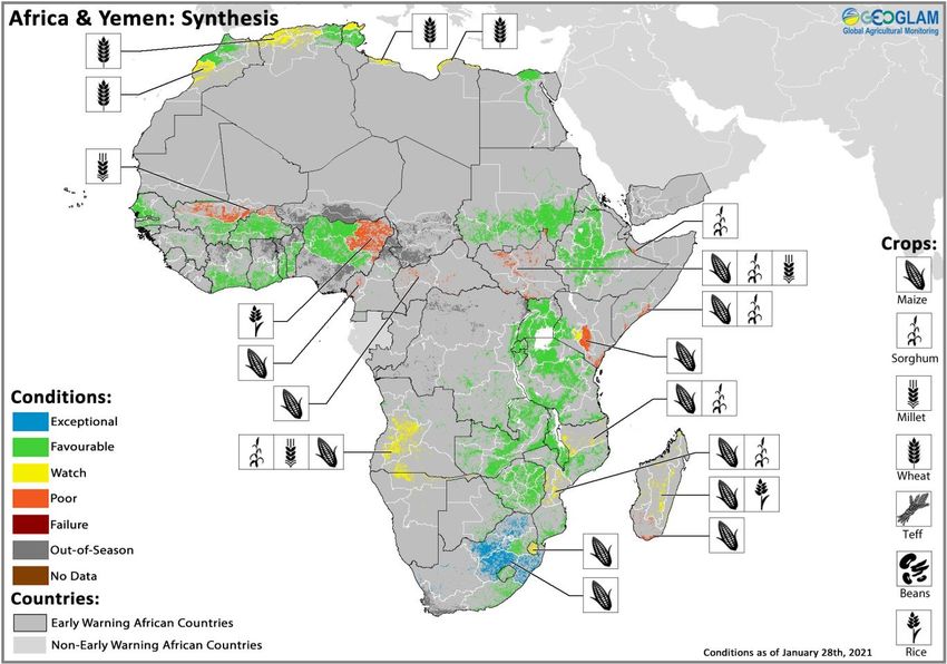
5         No. 57 – February 2021                                                                       Crop Monitor for Early Warning

Seasonal Forecast Alert: Below-average 2021 March-April-May rains are anticipated across parts of
Eastern Africa
Current and forecast ocean and atmosphere conditions continue to raise concern about a below-average 2021 March-April-May
(MAM) “long” rains season. A Pacific temperature configuration conducive to drier outcomes is currently present and is forecast to
remain active for MAM 2021.
In recent years, Pacific Ocean sea surface temperatures have often provided early indications of below-average long rains in eastern
East Africa. A much warmer-than-average western and subtropical Pacific, combined with cooler-than-average central-eastern Pacific
temperatures, tends to produce a teleconnection that disrupts typical moisture patterns, leading to an increased chance of below-
average “long” rains. An analog assessment of MAM seasons in the past 20 years has shown a greater than 50% chance of below-
normal rainfall.
This below-normal outlook for MAM 2021 in the eastern Horn is based on the persistence of cool equatorial central Pacific sea
surface temperatures accompanied by very warm (1 to 2+ standard deviations above-average) western and subtropical northern
Pacific sea surface temperatures (Figure 1- left). At present, a moderate to strong La Niña in the spring of 2021 is likely (55% chance
for MAM 2021). Thus, heightened concern for MAM appears warranted. Dynamic forecast models perform poorly at this lead time
for MAM, while statistical approaches do reasonably well. A statistical forecast based on the observed difference between western
and central-eastern Pacific sea surface temperatures indicates a range of outcomes from very poor to average (Figure 1- right).
Therefore, below-normal rains appear likely, but considerable uncertainty remains.

Figure 1. Global sea surface temperatures and forecast eastern East Africa March-April-May precipitation. Top left: Observed January 17 to January 23,
2021 sea surface temperature (SST) anomalies. Image from NOAA PSL Map Room. Bottom left: North American Multi-Model Ensemble (NMME) forecast
March to May 2021 SST standardized anomalies based on January 2021 initial conditions. Image from the NOAA CPC NMME webpage. Right: Scatter
plot of regression-based forecasts for 1997 to 2021 eastern East Africa March-April-May precipitation. Forecast predictors are observed preceding-year
December SST in the western and subtropical northern Pacific and in the central-eastern equatorial Pacific (Nino4 region). These regions are overlaid on
the top-left SST map. The red circle on the scatter plot shows the statistical model prediction for the MAM 2021 standardized precipitation (SPI) value.
The red line shows the 80% confidence interval. Bold lines demarcate the below-normal rainfall category based on a 1981-2010 baseline (=below -0.5
Z). Other years with much warmer-than-average western and subtropical Pacific SST and cooler-than-average central-eastern Pacific SST are colored
orange. Image from the UCSB CHC Blog.
Source: UCSB Climate Hazards Center

                                                 The Crop Monitor for Early Warning is a part of GEOGLAM,
                                                     a GEO global initiative. www.cropmonitor.org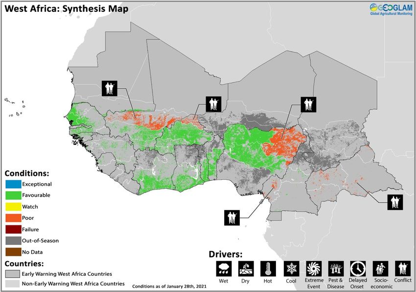
6         No. 57 – February 2021                                                                    Crop Monitor for Early Warning

East Africa & Yemen

Crop condition map synthesizing Maize 1 conditions as of January 28th. Crop conditions over the main growing areas are based on a combination of
inputs including remotely sensed data, ground observations, field reports, national, and regional experts. Conditions that are other than favourable
are labeled on the map with their driver.

Across the north of the region in Eritrea, Ethiopia, South Sudan, and Sudan as well as in western Kenya, harvesting of main season
cereals finalized in January while rice crops are still developing in the United Republic of Tanzania. Favourable crop production
resulted across Sudan and much of Ethiopia despite extreme flooding during the season and localized production shortfalls in South
Somali, Afar, and Tigray regions of Ethiopia due to combined effects of dry conditions, desert locusts, and insecurity. Poor production
resulted in South Sudan due to flooding, ongoing conflict, and socio-economic concerns. Across the south of the region in Burundi,
Rwanda, Uganda, north and eastern United Republic of Tanzania, and Somalia as well as in southern South Sudan, harvesting of
2020 October to December (OND) Short Rains cereal crops finalized in January while crops are still developing in Kenya for harvest
from February. In bimodal areas, the OND 2020 rainfall season, which is critical for crop production in southern and southeastern
Ethiopia, Kenya, and most of Somalia, was mostly below-average. As a result, poor crop production resulted in Kenya, parts of
Somalia, South Sudan, and northern United Republic of Tanzania. The 2021 March to May (MAM) rainfall season is also likely to
result in a second consecutive season of below-average rainfall, owing to the presence of La Niña conditions (See Seasonal Forecast
Alert Pg. 5 and Regional Outlook Pg. 8). Also, the desert locust outbreak continues to threaten crops in southern and southeastern
Ethiopia, northern Kenya, Somalia, and western Yemen (See Desert Locust Alert Pg. 4).

Northern East Africa & Yemen
In Ethiopia, harvesting of Meher season crops finalized in January under mostly favourable conditions with some localized production
shortfalls in South Somali Region where dry conditions impacted crop development, Afar Region where desert locusts resulted in
crop damage, and Tigray Region due to ongoing insecurity. In Tigray Region, conflict that erupted in early November has resulted in
limited access and abandonment of fields as well as displacements within the region, across regional boundaries to Amhara and Afar
Regions, and across national borders to Sudan. As a result, some farmers have missed the harvest season. Planting of Belg season
(short rains) cereal crops will take place from mid-February to be harvested from June. Forecast below-average February to May 2021
rainfall may negatively impact Belg season crops (See Seasonal Forecast Alert Pg. 5 and Regional Outlook Pg. 8). In Eritrea, harvesting
of main season sorghum and winter wheat crops finalized in January under favourable conditions. In Sudan, harvesting of main season
millet and sorghum crops finalized in January, and final yields were favourable. Despite devastating widespread flooding in September
that led to substantial crop losses in combination with COVID-19 related labour shortages, planted area of both millet and sorghum
crops increased due to high market prices that promoted farmers to increase plantings, adequate availability of agricultural inputs
and fuel, and increased availability of agricultural finance. Furthermore, sorghum crops benefitted from the extended rainy season to
October, resulting in production above the five-year average. Also, millet crops in key producing western areas were less affected by

                                                The Crop Monitor for Early Warning is a part of GEOGLAM,
                                                    a GEO global initiative. www.cropmonitor.org
7         No. 57 – February 2021                                                                     Crop Monitor for Early Warning

floods compared to eastern sorghum producing areas and were more
tolerant to waterlogging than other crops, resulting in production above
the five-year average. Winter wheat crops continue to develop in the north
and east for harvest from March, and overall conditions are favourable.
However, socio-economic issues remain a concern across the country as a
rapid increase in inflation rates, protracted economic crisis exacerbated by
COVID-19 related restrictions, and fuel shortages continue to impact
farmers and increase prices of agricultural inputs, further inflating
production and transportation costs. In South Sudan, harvesting of main
season cereals and second season maize and sorghum crops finalized in
January. Despite heavy rains and seasonal flooding since July of last year
as well as pockets of ongoing conflict and socio-economic challenges,
aggregate cereal production increased for a second consecutive year due
to improved security that allowed for an expansion of planted area. While
the 2020 cereal production is above the five-year average, it remains well
below pre-conflict levels of production.

Southern East Africa
In Somalia, harvesting of Deyr season maize and sorghum crops finalized
in January. While overall cereal production was near-average due to good
Deyr 2020 rains in the main producing sorghum regions of Bay and Bakool
as well as the main producing maize region of Lower Shabelle, poor
                                                                                     For detailed description of the pie chart please see description box on Pg. 19.
production resulted in several southeast, central, and northwestern areas
due to erratic rainfall, damage from Tropical Storm Gati, and desert locust
                                                                                               impacts. In October, key producing southern
                                                                                               cropping areas were affected by a late-onset
                                                                                               and poor performance of Deyr rains while
                                                                                               central regions experienced average to
                                                                                               above-average rains. Then from mid-October
                                                                                               to November, intermittent heavy Deyr
                                                                                               seasonal rainfall benefitted crop conditions
                                                                                               but resulted in widespread flooding and crop
                                                                                               losses in south and central regions along the
                                                                                               Juba and Shabelle rivers as well as rainfed
                                                                                               areas of Shabelle. However, cumulative
                                                                                               rainfall in parts of the south remained below-
                                                                                               average. Also, in late November, heavy rains
                                                                                               and strong winds from Tropical Cyclone Gati
                                                                                               affected northern regions, bringing up to
                                                                                               eight inches alone over two days in areas that
                                                                                               typically receive four inches of rain per year.
                                                                                               In addition, desert locust infestations that
                                                                                               were previously confined to north and central
                                                                                               pastoral regions expanded to key cropping
Crop condition map synthesizing Maize 2 conditions as of January 28 . Crop conditions over the
                                                                    th
                                                                                               areas in the south and resulted in damages to
main growing areas are based on a combination of inputs including remotely sensed data, ground
observations, field reports, national, and regional experts. Conditions that are other than
                                                                                               crops in south and central regions of Hiiraan,
favourable are labeled on the map with their driver.                                           Middle Shabelle, Galgaduud, Mudug, Bay,
                                                                                               and Gedo. Land preparation and planting of
Gu season maize and sorghum crops will begin in March. In Uganda, harvesting of second season maize crops finalized in January
under favourable conditions. While rainfall was below-average in north and eastern regions in December 2020, prior October and
November rainfall was sufficient to support crop development. Land preparation and planting of main season crops will begin in
March. Across the main producing west in Kenya, Rift Valley harvesting of Long Rains maize and rice crops finalized in January under
favourable conditions, and farmers are preparing fields for the upcoming season. There is concern for Short Rains maize crops for
harvest from February due to below-average and erratic rains in several areas and desert locust presence (See Desert Locust Alert Pg.
4). The October to December rainfall season has been erratic and below-average, lasting for up to a month and impacting crops
across much of the east, coast, and central areas. This has resulted in planting delays and moisture stress in marginal agricultural areas
and is expected to result in harvests approximately 30 percent below-average. Rainfall in early January could potentially improve soil
moisture and vegetation conditions in some areas (See Regional Outlook Pg. 8). However, for the March-April-May season, there are
concerns for below-average rainfall in eastern Kenya (See Seasonal Forecast Alert Pg. 5). In Burundi, harvesting of Season A maize
crops finalized in January under favourable conditions due to adequate rainfall, and planting of Season B maize will begin in March.
In Rwanda, harvesting of Season A maize crops finalized in January under favourable conditions, and planting of Season B maize
crops will begin in February. In northern bimodal areas of the United Republic of Tanzania, harvesting of Vuli season (short rains)
                                              The Crop Monitor for Early Warning is a part of GEOGLAM,
                                                  a GEO global initiative. www.cropmonitor.org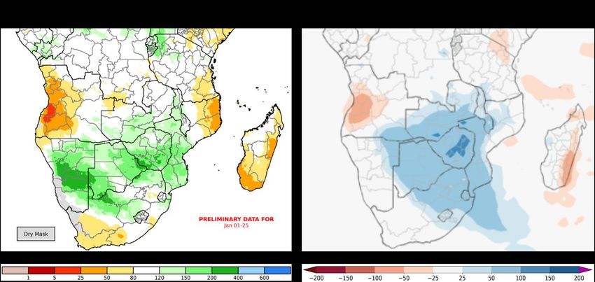
8        No. 57 – February 2021                                                                       Crop Monitor for Early Warning

maize crops finalized in January under generally favourable conditions except in localized parts of the northeastern regions bordering
Kenya where dry conditions impacted final production. Planting and development of Msimu (long rains) cereals continued under
favourable conditions. Short term forecasts indicate a likelihood of increased rainfall for south and central areas while drier-than-
average conditions will continue in the north (See Regional Outlook Pg. 8).

 Regional Outlook: Above-average rainfall expected across parts of Tanzania while
 below-average rains are likely in parts of Kenya and Ethiopia
 The October-to-December rainy season was below-average in large portions of Ethiopia, Somalia, and Kenya, and average to
 above-average in South Sudan, Uganda, northern Tanzania, and along the western border of Kenya. December was mainly drier-
 than-average in much of Kenya, southern Somalia, northern Uganda, and southern Ethiopia. Since late December, rainfall has
 been moderately below-average in southwestern Ethiopia and in parts of western, central, and southern Kenya. There were some
 atypical rain events in parts of eastern Kenya in late December and in parts of southern Kenya in early January. Tanzania and
 southern Uganda received average to above-average rainfall, aside from deficit areas in the south and in parts of Arusha.
 According to the two-week GEFS forecast, rainfall is expected across southern parts of the region, primarily in Tanzania and
 potentially also in western and southern Kenya. Drier-than-average conditions are forecast for Ethiopia. Figure 1 shows an
 extended outlook of the recent rainfall (Left) and the seasonal rainfall (Right), based on a January 26 th forecast. The longer range
 SubX forecast, for late January to late February, indicates overall average rain totals in most of the region and below-average
 amounts near the Kenya-Tanzania border.
 In the eastern and northern Horn hotter-than-average temperatures were observed in November and December, and in January
 in some areas. Models are forecasting average to above-average daytime temperatures during the next 30-days in these areas
 and increased chances for above-normal temperatures during February-to-April. In the worst affected areas, there is increased
 likelihood for rapid deterioration of rangeland conditions (pasture and surface water) in coming months.
 For the 2021 March-to-May rainfall season, there are concerns for below-average rainfall in eastern East Africa, associated with
 ocean-atmosphere conditions that are forecast to persist during the coming months. Many of these areas of concern received
 below-average rainfall during the October-to-December season (See Seasonal Forecast Alert Pg. 5).

 Figure 1. Estimated and forecasted rainfall for December 26th, 2020, to February 10th, 2021, and October 1st, 2020, to February 10th, 2021. Both maps
 are UCSB Climate Hazards Center Early Estimates, which compares 2020/21 rainfall amounts to the 1981-2019 CHIRPS average. The map on the
 left shows the difference from average for December 26th to February 10th if the 15-day unbiased GEFS forecast from January 26th materializes. The
 map on the right shows the percent-of-average rainfall for October 1st, 2020 to February 10th, 2021 if the 15-day unbiased GEFS forecast from January
 26th materializes.
 Source: UCSB Climate Hazards Center.

                                                The Crop Monitor for Early Warning is a part of GEOGLAM,
                                                    a GEO global initiative. www.cropmonitor.org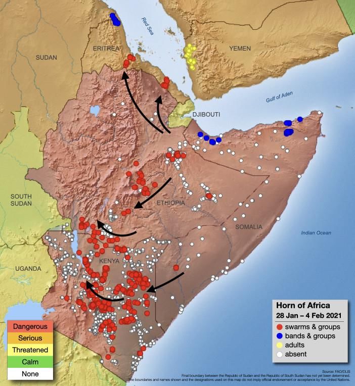
9         No. 57 – February 2021                                                                     Crop Monitor for Early Warning

West Africa

Crop condition map synthesizing information as of January 28th. Crop conditions over the main growing areas are based on a combination of inputs
including remotely sensed data, ground observations, field reports, national, and regional experts. Crops that are in other than favourable conditions
are labeled on the map with their driver.

In West Africa, harvesting of main season cereals finalized in Cape Verde, southern Cameroon, the Central African Republic,
Senegal, southern Mauritania, southern Mali, Burkina Faso, Guinea-Bissau, Guinea, and Sierra Leone. In the southern part of the
subregion, harvesting of second season cereals finalized in southern Cote d'Ivoire, southern Ghana, southern Togo, southern Benin,
and northern Nigeria while in the northern part, second season rice continues to develop in southern Mauritania and southern Mali
to be harvested from mid-February. Overall conditions are favourable except in Cape Verde due to dry conditions and delayed rainfall
onset as well as in southwestern Cameroon, the Central African Republic, northeastern Burkina Faso, northeast Nigeria, and north-
central Mali due to ongoing conflict impacting agricultural practices. In the Central African Republic, increased violence related to
the December 27th, 2020 elections triggered new population displacements, particularly in the northwest and centre. About 58,000
people are estimated to be internally displaced as a result of election-related insecurity. In Nigeria, an upsurge in violence between
armed groups and communal conflicts has driven new displacements in northeast, northwest, and northcentral regions. As a result,
many households have lost their livelihoods and are unable to carry out agricultural activities. In Timbuktu region of Mali, the impacts
of the security and socio-political crisis in combination with impacts from the COVID-19 pandemic have increased production costs
for irrigated crops. Furthermore, the embankment of the Daye plain broke in early December, exacerbating previous river flooding.
The floods inundated the rice-growing plains as well as irrigated village and market gardening perimeters and resulted in crop losses.

                                                The Crop Monitor for Early Warning is a part of GEOGLAM,
                                                    a GEO global initiative. www.cropmonitor.org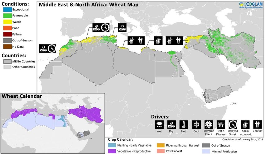
10        No. 57 – February 2021                                                                    Crop Monitor for Early Warning

Middle East & North Africa

Crop condition map synthesizing information as of January 28th. Crop conditions over the main growing areas are based on a combination of inputs
including remotely sensed data, ground observations, field reports, national, and regional experts. Crops that are in other than favourable conditions
are labeled on the map with their driver.
Throughout the Middle East and North Africa, wheat crops are in vegetative to reproductive stage for harvest from May onwards.
There is concern for crop conditions in central Algeria, western Morocco, and northern Tunisia where a delayed seasonal rainfall
onset and dry conditions continue to impact crop development. The two-week forecast from January 26th indicates drier-than-average
conditions in and near some of the recent deficit areas. However, the 30-day SubX forecasts indicate generally average rainfall for the
next 30 days. In Iraq and Iran, abundant rainfall in mid-January decreased moisture deficits, albeit not uniformly across all cropping
areas. As of the second dekad of January, below-average biomass likely as a result of insufficient rainfall prevailed in Golestan District
in northeastern Iran as well as Ninewa Governorate in northern Iraq. In Al Hasakah Governorate of Syria, the primary wheat-
producing region located in the northeast, poor precipitation and dry conditions prevailed until early January, but good rainfall in the
second dekad of January and above-average temperatures are expected to boost winter cereal growth. In addition, ongoing conflict
and socio-economic concerns including currency depreciation and high transportation costs as a result of fuel shortages continue to
impact agricultural activities. In Libya, ongoing conflict continues to limit farmer's ability to purchase agricultural inputs, access fields,
and attend to their fields. In Egypt, harvesting of Nili season (Nile Flood) rice crops finalized in January under favourable conditions.

                                                The Crop Monitor for Early Warning is a part of GEOGLAM,
                                                    a GEO global initiative. www.cropmonitor.org
11 No. 57 – February 2021 Crop Monitor for Early Warning
Southern Africa
Crop condition map synthesizing information as of January 28th. Crop conditions over the main growing areas are based on a combination of inputs
including remotely sensed data, ground observations, field reports, national, and regional experts. Crops that are in other than favourable conditions
are labeled on the map with their driver.
In Southern Africa, main season cereals are in vegetative to reproductive stage throughout the subregion to be harvested from April.
The southern half of the subregion received heavy rainfall in December and early January that benefitted crop development while
also leading to floods and waterlogging in some areas. Conversely, below-average rainfall continued in some west, east, and far
southern parts of the region, causing rainfall deficits in some areas (See Regional Outlook Pg. 13). There is developing concern in west
and southwestern Angola, eSwatini, and northern Namibia and significant concern in southern Madagascar as below-average
rainfall and above-average temperatures are impacting crop development. Also, on January 20th, Tropical Storm Eloise made landfall
in northeastern Madagascar, bringing heavy rains and flooding before crossing the Mozambique Channel where it strengthened to
a tropical cyclone and made landfall in central Mozambique on January 23rd, raising concern in central areas still recovering from
Tropical Cyclone Idai in March 2019. Eloise then weakened into an overland depression on January 24th and moved towards South
Africa, bringing heavy rainfall to northern South Africa, southeastern Zimbabwe, and southern Botswana. The rains in South Africa
also have the potential to increase the water levels of rivers that flow into Mozambique, increasing the risk of further flooding in
cyclone-affected areas of Mozambique. Seasonal cyclone forecasts indicate a higher than normal probability of increased cyclone
activity between February and April 2021 in the southwest Indian Ocean which may further affect parts of the subregion (See Regional
Outlook Pg. 13). African Migratory Locusts (AMLs) as well as brown and red locusts were reported over Angola, Namibia, Zambia,
Botswana, Zimbabwe, and South Africa and are likely to persist as wet conditions continue. Though the locust outbreak is currently
not impacting cropped areas significantly, except in Namibia where 50,000 hectares of cropland were affected, it poses a risk to
2020/2021 summer cropping harvest and winter irrigated crops if not effectively controlled.
In the Democratic Republic of Congo, harvesting of main season maize crops finalized in central areas while planting of second
season maize crops began in central and southeastern areas, and overall conditions are favourable. In the south and western coastal
areas of Angola, abnormal dry conditions and above-average temperatures in January have impacted vegetation conditions.
Conversely, in the minor producing north and eastern areas, crop conditions are favourable despite sporadic rainfall in the north.
Below-average rainfall is forecast to continue in the major producing central-western areas through late February (See Regional
Outlook Pg. 13). In Zambia, overall conditions are favourable for main season maize crops as good rainfall over most areas benefitted
crop development, though heavy rains in early January caused localized flooding and destroyed maize crops in Gwembe District in
The Crop Monitor for Early Warning is a part of GEOGLAM,
a GEO global initiative. www.cropmonitor.org12 No. 57 – February 2021 Crop Monitor for Early Warning
Southern Province. Additionally, the AML outbreak is under
control and has not impacted cropped areas significantly. In
Mozambique, crop conditions are mixed due to localized dry
conditions and conflict in the north as well as impacts from
Tropical Cyclones Chalane and Eloise, which affected the same
areas that were still under recovery from Tropical Cyclone Idai in
2019. On December 30th, 2020, Tropical Storm Chalane made
landfall and affected the central provinces of Sofala and Manica
with strong winds and heavy rains that contributed to rising water
levels of several rivers and basins. However, the storm only
caused minimal damage to the agricultural sector. On January
23rd, Tropical Cyclone Eloise made landfall as a category two
storm again in Sofala Province, and the additional rains are likely
to have overflowed the Limpopo river basin, increasing the risk of
flooding in northern Gaza Province and Limpopo valley. As of
January 29th, 314,000 people have been affected, and in excess of
100,000 hectares of crops have been flooded. In Namibia, there
is concern for main season maize and millet crops due to below-
average precipitation and the presence of AMLs, which have
affected 50,000 hectares of cropland. In Botswana, current
conditions for crop development are favourable. Widespread
rainfall was received following Tropical Cyclone Eloise, which is
expected to benefit crops in most areas but may have caused
localized crop damage in Southern-Central District (See Regional
Outlook Pg. 13). While current conditions are favourable for crop
development in Zimbabwe, several southeast and central areas For detailed description of the pie chart please see description box on Pg. 19.
were affected by heavy rains and flooding in early January,
including Chiredzi, Gokwe, Buhera, and Zaka. In late January, additional heavy rains from Tropical Cyclone Eloise resulted in flooding,
mudslides, and destruction of infrastructure in the east and southeastern provinces of Manicaland, Mashonaland East and Central,
Matabeleland South, and Masvingo. In Madagascar, there is concern for main season rice and maize crops due to below-average
precipitation and above-average temperatures over south and central areas. In the south, crops are unlikely to recover as current
severe drought is compounding the impacts of previous successive droughts in the last few seasons. Abnormal dryness also impacted
eastern coastal areas in mid-January. Below-average rainfall is forecast to continue through late February in south and eastern areas
and may worsen rainfall deficits (See Regional Outlook Pg. 13). Conversely, on January 20th, Tropical Storm Eloise brought heavy rains,
strong winds, and flooding as it passed through northeastern districts of Antalaha, Maroantsetra, Vavatenina, and Toamasina before
crossing over northern areas and re-entering the Mozambique Channel. In eSwatini, late-onset rains and dry conditions resulted in
seasonal planting delays and a need for replanting in some areas due to early crop wilting. Rainfall improved from December, and
heavy rainfall in January from Tropical Cyclone Eloise has affected several areas, and most rivers in the country are flooded. In Lesotho,
weather conditions since the start of the rainy season in October have been beneficial for plantings and crop development with
slightly above-average cumulative rainfall. In South Africa, main season maize crops are in vegetative to reproductive stage under
favourable conditions due to widespread above-normal rainfall over most of the summer grain-producing region. Favourable rainfall
prospects and near-normal temperatures since the start of planting in October and November, in combination with remunerative
crop prices, encouraged farmers to expand the planted area for the 2021 maize crop, up six percent year on year. However, heavy
rainfall from Tropical Cyclone Eloise in late January added to the already saturated grounds and caused flooding in Lowveld areas of
Limpopo and Mpumalanga provinces.
The Crop Monitor for Early Warning is a part of GEOGLAM,
a GEO global initiative. www.cropmonitor.org13 No. 57 – February 2021 Crop Monitor for Early Warning
Regional Outlook: Above-average February rainfall is forecast across the central
and southeastern areas while below -average rainfall is expected over rainfall
deficit areas
Since December 1st, rainfall has been above-average across central parts of Southern Africa, including Zimbabwe, Botswana,
southern Zambia, and from Namibia to central and southern Mozambique, including, central and northeastern South Africa (Figure
1-left). Rainfall was below-average in northeastern Mozambique, southern and eastern Madagascar, western Angola, and marginal
rain areas of southwestern South Africa.
December-to-January rainfall deficits are severe in southern Madagascar, northeastern Mozambique, and western Angola. Some
areas received the lowest amounts of the 40-year CHIRPS record, according to observed and preliminary data for December 1st to
January 25th. Above-average rainfall has been exceptional in some of the south-central region areas, in part due to Tropical Storm
Chalane, which passed over northern Madagascar, south-central Mozambique, and Zimbabwe in late December followed by
Tropical Cyclone Eloise in the third week of January. Rainfall amounts in parts of southern Zimbabwe, western Mozambique,
Botswana, Namibia, and north-central South Africa presently rank among the wettest on record. If the two-week forecast from
January 26th materializes, more central region areas will exhibit near-record level rainfall for December to early February.
Above-average rainfall is forecast in central and southeastern areas for the late-January to late-February period. Below-average
rainfall is forecast in central-western Angola and in southern and eastern Madagascar. Similar forecasts from five SubX models
indicate high confidence in this outlook for the region overall, while outcomes are likely to vary across specific locations. Figure 1-
right shows the SubX 30-day model mean forecast.
Following observed rainfall from December to late January, if the SubX 30-day forecast materializes, December 2020 to February
2021 rainfall will follow a similar regional pattern to that which was forecast by the NMME in September 2020. That forecast was
shown in the Crop Monitor for Early Warning October 2020 Regional Outlook. Based on January 2021 initial conditions, the NMME
forecast for February-to-April rainfall shows low model agreement in central and southeastern areas and increased chances of
above normal rainfall in Namibia, central-western South Africa, and parts of central Mozambique.
Figure 1. Estimated rainfall since December 1st, and a 30-day rainfall forecast anomaly from January 28th. The left panel is a UCSB Climate Hazards
Center Early Estimate, which compares 2020/21 rainfall amounts to the 1981-2019 CHIRPS average for the same period. The right panel is a 30-day
forecast from January 28th. The image shows the average of five Subseasonal Experiment (SubX) model forecasts starting from that day; model initial
conditions were within several days. The anomaly is based on the 1999 to 2016 model average. Skill assessments of SubX can be accessed here.
Source: UCSB Climate Hazards Center.
The Crop Monitor for Early Warning is a part of GEOGLAM,
a GEO global initiative. www.cropmonitor.org14 No. 57 – February 2021 Crop Monitor for Early Warning
Central & South Asia
Crop condition map synthesizing information as of January 28th. Crop conditions over the main growing areas are based on a combination of inputs
including remotely sensed data, ground observations, field reports, national, and regional experts. Crops that are in other than favourable conditions
are labeled on the map with their driver.
In Central and South Asia, winter wheat crops are in dormancy stage across Afghanistan, Kazakhstan, Kyrgyzstan, Pakistan,
Tajikistan, Turkmenistan, and Uzbekistan, and overall conditions are favourable except in Afghanistan and southern areas
of Turkmenistan and Uzbekistan where below-average precipitation has been received and is forecast to continue into February
(See Regional Outlook Pg. 15). In Turkmenistan and Uzbekistan, in addition to the below-average precipitation, colder than average
temperatures until the first dekad of January raised concerns; however, temperatures increased in the second and third dekad of the
month. In Kazakhstan, planting of the minor winter wheat crop, accounting for 3.5 percent of total annual wheat production, finalized
in November 2020 and will be harvested between June and August 2021. In mid-January, the main producing regions in the south
and southeast experienced above-average temperatures, and the southeast experienced above-normal precipitation which benefitted
soil moisture levels. However, the warm temperatures in the Almaty and Zhambyl regions in the southeast has the potential to lead
to overgrowth of winter wheat in uneven snow cover and result in crop damage during strong winds. Also, lack of snow in the fields
of Turkestan region in the south may cause winterkill in the case of severe frosts. Elsewhere in Kazakhstan as well as Tajikistan and
Kyrgyzstan, snow cover is sufficient and has been present since late November 2020. In Afghanistan, below-average precipitation
has prevailed throughout much of the country, and snow water volumes that were above-average in December 2020 are now below-
normal. While winter-planted wheat crops are in dormancy, recent below-average precipitation, which is also forecast to continue in
February (See Regional Outlook Pg. 15), combined with above-average temperatures may result in below-average snowmelt runoff
and moisture stress for winter wheat crops. In addition, this may also limit seasonal water availability for spring wheat to be planted
from February. In Pakistan, harvesting of main season rice crops finalized in December under favourable conditions, and production
is estimated at 12.3 million tonnes, reflecting the high level of plantings in response to good prices and strong demand as well as
good rainfall throughout the season. Favourable weather conditions since October 2020 and sufficient irrigation water supplies
benefitted land preparation and planting activities of Rabi wheat crops, of which 90 percent are irrigated. Planted area is forecast at
an above-average level of 9.2 million tonnes due in part to record domestic prices and Government programmes supporting wheat
production via price support and subsidies for fertilizers and pesticides.
The Crop Monitor for Early Warning is a part of GEOGLAM,
a GEO global initiative. www.cropmonitor.org15 No. 57 – February 2021 Crop Monitor for Early Warning
Regional Outlook: Below-average rainfall expected across parts of the region for
the February to April 2021 period
October to January precipitation was mainly average to below-average across the region, with above-average precipitation in
parts of northern Afghanistan. Average to below-average conditions are expected for late January to early February, based on the
January 26th two-week forecast. Figure 1-left shows the extended outlook for October 1st to February 10th precipitation in terms
of the difference from average for that period. The outlook shows potential for season-to-date deficits of 50 mm or higher, or less
than 80% of average, in northeastern Iran, southern Afghanistan, northern Pakistan, and other areas.
Over the next 30 days, SubX models forecast average to below-average precipitation. The SubX models, overall, forecast below-
average precipitation in central and eastern Afghanistan, northern Pakistan, southern Tajikistan, and northwestern India (See Global
Climate Outlook Pg. 3).
Seasonal forecasts, from the NMME in early January, retain a pessimistic outlook with increased chances of below-normal February-
to-April precipitation (Figure 1-right). The models also predict above-normal temperatures across the region. If these forecasts
materialize, such a combination could have consequences for snowpack and water availability in winter and spring cereals as well
as flooding risks.
Figure 1. Estimated and forecasted rainfall since October 1st, and a 3-month probability forecast. The left panel is a UCSB Climate Hazards Center
Early Estimate, which compares 2020/21 rainfall amounts to the 1981-2019 CHIRPS average. The map shows the difference from average for October
1st to February 10th, if the 15-day unbiased GEFS forecast from January 26th materializes. On the right is the 3-month NMME experimental probabilistic
forecast for February to April 2021, based on January 2021 initial conditions. The forecast probability is calculated as the percentage of all 79 NMME
ensemble members that fall in a given tercile (above/below/near normal). White color indicates there is no dominant category across the model
forecasts. NMME image from https://www.cpc.ncep.noaa.gov/products/international/nmme/nmme_seasonal.shtml
Source: UCSB Climate Hazards Center.
The Crop Monitor for Early Warning is a part of GEOGLAM,
a GEO global initiative. www.cropmonitor.org16 No. 57 – February 2021 Crop Monitor for Early Warning
Southeast Asia
Crop condition map synthesizing rice conditions as of January 28th. Crop conditions over the main growing areas are based on a combination of inputs
including remotely sensed data, ground observations, field reports, national, and regional experts. Crops that are in other than favourable conditions
are labeled on the map with their driver.
In northern Southeast Asia, harvesting of wet-season rice finalized in
December, and overall favourable production resulted due to sufficient
rainfall during the growing season. However, crop damages from
southwest monsoon and typhoon related flooding in the Delta region of
Myanmar, Mekong basin of Cambodia, and Northern Luzon part of
Philippines is expected to decrease production in affected areas. Planting
of dry-season rice commenced in January under favourable conditions,
and planted area is expected to decrease due to limited irrigation water
availability in some countries. In Indonesia, conditions are favourable as
the harvesting of dry-season rice is wrapping up with a large increase in
harvested area of 4.9 million hectares, a 13.1 percent increase compared
to last year. Conditions are also favourable for wet-season rice as sowing
enters the fourth month, and the harvesting of earlier sown crops begins.
Total sown area of wet-season rice significantly increased this year
compared to last year due to heavy rainfall as the peak of La Niña between
December 2020 and January 2021 coincided with the peak of the rainy
season that typically occurs between January and February. Despite
reports of flooding and landslides, there has been no significant damage
to rice crops, and growing conditions are favourable due to sufficient
irrigation water supply, particularly in northern Java Island. In the
Philippines, wet-season rice harvesting is wrapping up under favourable
conditions except for Northern and Southern Luzon, which were impacted
by flooding from three typhoons. Total production reached 7.39 million
metric tonnes with a yield of 4.24 metric tonnes. Dry-season rice is in For detailed description of the pie chart please see description box on Pg. 19.
The Crop Monitor for Early Warning is a part of GEOGLAM,
a GEO global initiative. www.cropmonitor.org17 No. 57 – February 2021 Crop Monitor for Early Warning
tillering to young panicle forming stage under generally favourable conditions with some areas of concern remaining in North Luzon
Agribusiness due to earlier lodging and flooding resulting from Tropical Storm Krovanh in mid-December and a tropical depression
in January (See Regional Outlook Pg. 18). In Thailand, wet-season rice harvest is wrapping up under favourable conditions despite
some damage in the northeast due to persistent rainfall and flooding in October. Dry-season rice is in tillering stage under mixed
conditions as a result of recent prolonged cold weather from December 2020 to January 2021 and a lack of irrigation water. Low
irrigation water availability is also expected to reduce the total sown area and yields this year compared to last year as dry-season
rice crops are mostly irrigated. In Viet Nam, harvest is wrapping up for the autumn-winter (wet-season) crop in the south under
favourable conditions, and yields are estimated at 5.62 tonnes per hectare, a 2.2 percent increase compared to last year due to good
weather conditions during the growing season. Conditions are also favourable for the sowing of the winter-spring (dry-season) crop
in the south, although progress is slower than last year due to the delay in agricultural work and shortage of irrigation water. In Laos,
sowing of dry-season rice is underway under favourable conditions and with sufficient irrigation water supply. Planted area has
reached 47,000 hectares, 52 percent of the national production plan. In Myanmar, harvesting of wet-season rice finalized in January
with 12.3 million tonnes produced and a below-average yield of 3.83 tonnes per hectare. While flood damage during monsoon season
did not significantly affect the paddy crop, the final average yield is low due to poor rainfall during the reproductive stages and limited
irrigation water supply. Planting of dry-season rice has reached 434,000 hectares, 47.4 percent of the national plan. While current
weather conditions are favourable for crop development, planted area is expected to reduce considerably compared to last year due
to limited irrigation water supply in dams and reservoirs that may incentivize farmers to substitute other winter crops. In Cambodia,
planting of dry-season rice has reached 125 percent of the national plan of 571,000 hectares due to government support of supply
water for areas with limited irrigation water availability. Weather conditions are favourable for crop development, and some areas
have started harvesting. In Sri Lanka, Maha season maize and rice crops are in vegetative to reproductive stage under favourable
conditions to be harvested from February. For rice crops, precipitation amounts since October have been near-average over the main
producing areas, benefitting planting and crop germination, particularly in the main producing North Western, North Central, Eastern,
and Uva provinces. Plantings have reached 95 percent of targeted area, as of the end of December, and Government support of free
irrigation water and fertilizer subsidies sustained plantings. For maize, plantings reached 85 percent of targeted area and are forecast
at an above-average level, reflecting the high demand by the local feed industry. In Bangladesh, harvesting of Aman season rice
crops finalized in January. While production levels are expected to decrease slightly from the previous year due to localized crop
damage from heavy rains in July and August that triggered flash floods and river overflows in the north, production will be close to
the five-year average. Planting of Boro season rice crops, accounting for 55 percent of the annual paddy output, continued in January
to be harvested in mid-April. Favourable weather conditions from November 2020 and adequate irrigation water supplies from above-
average June to October monsoon rains benefitted planting activities and crop germination. Planting prospects are favourable,
reflecting strong market prices as well as Government support programmes. In an attempt to increase productivity of paddy, the
Government encouraged hybrid rice cultivation through a series of measures including financial support and provision of hybrid
seeds. In Nepal, harvesting of main season rice crops finalized in January under favourable conditions due to good irrigation supply
from monsoon rains. Production is estimated at a near-record level of 5.6 million tonnes due to the high level of plantings and despite
localized damages to standing crops in western and central areas due to floods from heavy rains in June and September. Planting of
main season maize will begin in February for harvest from August.
The Crop Monitor for Early Warning is a part of GEOGLAM,
a GEO global initiative. www.cropmonitor.orgYou can also read